
Spencer Gulf
Encyclopedia
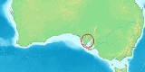
The Spencer Gulf is the westernmost of two large inlets on the southern coast of Australia
, in the state of South Australia
, facing the Great Australian Bight
. The Gulf is 322 km (200 mi) long and 129 km (80 mi) wide at its mouth. The western shore of the Gulf is the Eyre Peninsula
, while the eastern side is the Yorke Peninsula
, which separates it from the smaller Gulf St Vincent. The largest towns on the gulf are Whyalla
, Port Pirie
, and Port Augusta
. Among smaller towns on the gulf are Wallaroo
and Port Broughton.
in 1802, after George John Spencer
, the 2nd Earl Spencer
, an ancestor of Diana, Princess of Wales
. The official name is now Spencer Gulf. The gulf was also named Golfe Bonaparte by Nicholas Baudin at roughly the same time as Flinders, but the name did not catch (others, like the Fleurieu Peninsula
, did).
The area was first explored
on land by Edward John Eyre
in 1839 and 1840-41. Settlement of the shores of the Gulf began in the late 1840s.
. They are a favorite food of local dolphins, who have developed a sophisticated techniques for safely eating those creatures. The upper Spencer Gulf is also known for its snapper
fishing.
The area around the gulf, the Eyre
and Yorke Peninsula
s is the Eyre Yorke Block
bioregion
which was originally wooded shrubland but has now mainly been cleared for agriculture.
lies along the north-eastern coast of the Gulf; it comprises a 460 km2 strip of coastal land consisting mainly of intertidal
mudflat
s, mangrove
s and salt marsh
es. It was identified as an Important Bird Area
(IBA) by BirdLife International
because of its importance for the conservation of wader
s, or shorebirds.
Australia
Australia , officially the Commonwealth of Australia, is a country in the Southern Hemisphere comprising the mainland of the Australian continent, the island of Tasmania, and numerous smaller islands in the Indian and Pacific Oceans. It is the world's sixth-largest country by total area...
, in the state of South Australia
South Australia
South Australia is a state of Australia in the southern central part of the country. It covers some of the most arid parts of the continent; with a total land area of , it is the fourth largest of Australia's six states and two territories.South Australia shares borders with all of the mainland...
, facing the Great Australian Bight
Great Australian Bight
The Great Australian Bight is a large bight, or open bay, off the central and western portions of the southern coastline of mainland Australia.-Extent:...
. The Gulf is 322 km (200 mi) long and 129 km (80 mi) wide at its mouth. The western shore of the Gulf is the Eyre Peninsula
Eyre Peninsula
Eyre Peninsula is a triangular peninsula in South Australia. It is bounded on the east by Spencer Gulf, the west by the Great Australian Bight, and the north by the Gawler Ranges. It is named after explorer Edward John Eyre who explored some of it in 1839-1841. The coastline was first explored by...
, while the eastern side is the Yorke Peninsula
Yorke Peninsula
The Yorke Peninsula is a peninsula located north-west and west of Adelaide in South Australia, Australia, between Spencer Gulf on the west and Gulf St Vincent on the east. It has geographic coordinates of...
, which separates it from the smaller Gulf St Vincent. The largest towns on the gulf are Whyalla
Whyalla, South Australia
-Demographics:According to the 2006 Census the population of the Whyalla census area was 21,122 people, making it the second largest urban area in the state outside of Adelaide...
, Port Pirie
Port Pirie, South Australia
-Transport:Port Pirie is located off National Highway One. It is serviced by an airport five minutes out of the city.- Railways :The first railways in Port Pirie were of the narrow [3' 6"] gauge....
, and Port Augusta
Port Augusta, South Australia
-Electricity generation:Electricity is generated at the Playford B and Northern power stations from brown coal mined at Leigh Creek, 250 km to the north...
. Among smaller towns on the gulf are Wallaroo
Wallaroo, South Australia
Wallaroo is a port town on the western side of Yorke Peninsula in South Australia, 160 kilometres north-northwest of Adelaide. It is one of the three Copper Triangle towns famed for their historic shared copper mining industry, and known together as "Little Cornwall", the other two being Kadina ...
and Port Broughton.
History
The gulf was named Spencer's Gulph by explorer Matthew FlindersMatthew Flinders
Captain Matthew Flinders RN was one of the most successful navigators and cartographers of his age. In a career that spanned just over twenty years, he sailed with Captain William Bligh, circumnavigated Australia and encouraged the use of that name for the continent, which had previously been...
in 1802, after George John Spencer
George Spencer, 2nd Earl Spencer
George John Spencer, 2nd Earl Spencer KG PC FRS FSA , styled Viscount Althorp from 1765 to 1783, was a British Whig politician...
, the 2nd Earl Spencer
Earl Spencer
Earl Spencer is a title in the Peerage of Great Britain that was created on 1 November 1765, along with the title Viscount Althorp, of Althorp in the County of Northamptonshire, for John Spencer, 1st Viscount Spencer, a great-grandson of the 1st Duke of Marlborough...
, an ancestor of Diana, Princess of Wales
Diana, Princess of Wales
Diana, Princess of Wales was the first wife of Charles, Prince of Wales, whom she married on 29 July 1981, and an international charity and fundraising figure, as well as a preeminent celebrity of the late 20th century...
. The official name is now Spencer Gulf. The gulf was also named Golfe Bonaparte by Nicholas Baudin at roughly the same time as Flinders, but the name did not catch (others, like the Fleurieu Peninsula
Fleurieu Peninsula
The Fleurieu Peninsula is a peninsula located south of Adelaide in South Australia, Australia. It was named after the French explorer and hydrographer Charles Pierre Claret de Fleurieu by the French explorer Nicolas Baudin as he mapped the south coast of Australia in 1802.Towns of interest in the...
, did).
The area was first explored
Eyre's 1839 expeditions
Edward John Eyre's two expeditions of 1839 to the interior of South Australia were his first expeditions as an explorer, if one discounts the two earlier trips he made down the Murray River to Adelaide, herding cattle and then sheep.-North:...
on land by Edward John Eyre
Edward John Eyre
Edward John Eyre was an English land explorer of the Australian continent, colonial administrator, and a controversial Governor of Jamaica....
in 1839 and 1840-41. Settlement of the shores of the Gulf began in the late 1840s.
Wildlife
Spencer Gulf, in particular a certain section of it north of Whyalla, is a breeding ground of Australian Giant CuttlefishAustralian Giant Cuttlefish
Sepia apama, also known as the Australian Giant Cuttlefish, is the world's largest cuttlefish species, growing to 50 cm in mantle length and over 10.5 kg in weight. Using cells known as chromatophores, the cuttlefish can put on spectacular displays, changing colour in an instant.S...
. They are a favorite food of local dolphins, who have developed a sophisticated techniques for safely eating those creatures. The upper Spencer Gulf is also known for its snapper
Australasian snapper
The Australasian snapper or Pagrus auratus is a species of porgie found in coastal waters of New Zealand and Australia. Although it is almost universally known in these countries as snapper it does not belong to the Lutjanidae family...
fishing.
The area around the gulf, the Eyre
Eyre Peninsula
Eyre Peninsula is a triangular peninsula in South Australia. It is bounded on the east by Spencer Gulf, the west by the Great Australian Bight, and the north by the Gawler Ranges. It is named after explorer Edward John Eyre who explored some of it in 1839-1841. The coastline was first explored by...
and Yorke Peninsula
Yorke Peninsula
The Yorke Peninsula is a peninsula located north-west and west of Adelaide in South Australia, Australia, between Spencer Gulf on the west and Gulf St Vincent on the east. It has geographic coordinates of...
s is the Eyre Yorke Block
Eyre Yorke Block
The Eyre Yorke Block is an Interim Biogeographic Regionalisation for Australia region and a World Wildlife Fund ecoregion covering the Eyre and Yorke Peninsulas around the Spencer Gulf on the coast of South Australia. -Location and description:...
bioregion
Interim Biogeographic Regionalisation for Australia
The Interim Biogeographic Regionalisation for Australia is a biogeographic regionalisation of Australia developed by the Australian Government's Department of the Environment, Water, Heritage and the Arts...
which was originally wooded shrubland but has now mainly been cleared for agriculture.
Important Bird Area
The Spencer Gulf Important Bird AreaSpencer Gulf Important Bird Area
The Spencer Gulf Important Bird Area comprises a 460 km2 strip of coastal land extending for about 100 km along the north-eastern coast of the Spencer Gulf, on the west side of the Yorke Peninsula of South Australia. It passes close to the towns of Port Germein and Port Broughton, and...
lies along the north-eastern coast of the Gulf; it comprises a 460 km2 strip of coastal land consisting mainly of intertidal
Intertidal zone
The intertidal zone is the area that is above water at low tide and under water at high tide . This area can include many different types of habitats, with many types of animals like starfish, sea urchins, and some species of coral...
mudflat
Mudflat
Mudflats or mud flats, also known as tidal flats, are coastal wetlands that form when mud is deposited by tides or rivers. They are found in sheltered areas such as bays, bayous, lagoons, and estuaries. Mudflats may be viewed geologically as exposed layers of bay mud, resulting from deposition of...
s, mangrove
Mangrove
Mangroves are various kinds of trees up to medium height and shrubs that grow in saline coastal sediment habitats in the tropics and subtropics – mainly between latitudes N and S...
s and salt marsh
Salt marsh
A salt marsh is an environment in the upper coastal intertidal zone between land and salt water or brackish water, it is dominated by dense stands of halophytic plants such as herbs, grasses, or low shrubs. These plants are terrestrial in origin and are essential to the stability of the salt marsh...
es. It was identified as an Important Bird Area
Important Bird Area
An Important Bird Area is an area recognized as being globally important habitat for the conservation of bird populations. Currently there are about 10,000 IBAs worldwide. The program was developed and sites are identified by BirdLife International...
(IBA) by BirdLife International
BirdLife International
BirdLife International is a global Partnership of conservation organisations that strives to conserve birds, their habitats and global biodiversity, working with people towards sustainability in the use of natural resources...
because of its importance for the conservation of wader
Wader
Waders, called shorebirds in North America , are members of the order Charadriiformes, excluding the more marine web-footed seabird groups. The latter are the skuas , gulls , terns , skimmers , and auks...
s, or shorebirds.