
Territorial evolution of the United States
Encyclopedia
This is a list of the evolution of the border
s of the United States
. This lists each change to the internal and external borders of the country, as well as status and name changes. It also shows the surrounding areas that eventually became part of the United States. Each stage has a map, to show what the specific makeup of the country was at any given time.
After achieving independence with the Treaty of Paris
, the United States expanded westward, enlarging its borders seven times, with two major border adjustments, one each with colonies of the United Kingdom
and Spain
, and several small disputes. The original thirteen states grew into fifty states
, most of which began as incorporated territories
. The general pattern seen in this is of territorial expansion, carving of organized territories from the newly acquired land, modification of the borders of these territories, and eventual statehood. Only two states, Nevada
and Missouri
, grew appreciably after statehood, and five, Georgia
, Massachusetts
, North Carolina
, Texas
, and Virginia
, lost land, in each case to form new states.
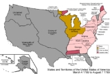
 March 4, 1789
The United States Constitution
came into effect, forming the new nation. Note that the states ratified at different times, but to simplify the map, the final result is shown here.
The United States achieved independence from the Kingdom of Great Britain
with the Treaty of Paris
on September 3, 1783, which established that the thirteen colonies were sovereign and independent states. The borders were established by Article 2 of the treaty, but with a couple of issues. First, it stated that the border would run west from the Lake of the Woods
to the Mississippi River
- at the time, it was not known that the headwaters of the Mississippi lay south of such a line, so the border has since been taken to run south from the lake to the river.
Some peculiarities to point out to those familiar only with the current borders: Many states had sea-to-sea grants from the British crown that they would not give up easily, so prior to this date, they ceded this land
to the federal government in exchange for their Revolutionary War
debts. However, Georgia
did not do so until much later, and Connecticut
ceded most land but kept its Western Reserve. Virginia ceded its claim to the territory north and west of the Ohio River
, and this land became unorganized territory
. North Carolina
also ceded its claim to its western counties, but this was not officially accepted by Congress until 1790. New York
ceded its claim on the Erie Triangle
to the federal government. At this point in history, all of the states except for Georgia and Virginia were at their present-day borders, except for some of the minor issues mentioned above.
West Florida
claimed a border further north than what the United States said it had. Its border had been 31° north when Spain ceded it to the United Kingdom
. The British later moved its border north to 32°38′ latitude, but when Spanish Florida
was ceded back to Spain
in the Treaty of Paris
, the British cited the original border at the 31st parallel north
, but Spain continued to claim the higher border. Also, the borders at the northern area of the Maine District of Massachusetts
and the area northwest of Lake Superior
remained disputed.
The Wedge
, disputed since the 17th century, remained a point of contention between Delaware
and Pennsylvania
.
The Vermont Republic
was a complex matter, with areas being claimed by New York
and New Hampshire
, but it existed as a de facto
unrecognized independent state.
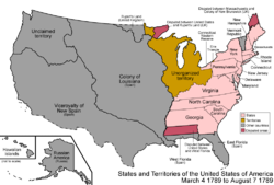
 August 7, 1789
The United States Congress affirmed the organization of the Territory North West of the Ohio River, or Northwest Territory
, under the terms of the Northwest Ordinance
. Northwest Territory consisted of present-day Illinois
, Indiana
, Michigan
, northeastern Minnesota
, most of Ohio
, and Wisconsin
. The Northwest Territory had previously been organized under the Articles of Confederation
on July 13, 1787, and was slightly modified under the new Constitution.
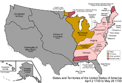 April 2, 1790
Congress accepts North Carolina
's cession of its western counties, which had initially been ceded on December 22, 1789. The land became unorganized territory.
 May 26, 1790
The Southwest Ordinance organized the Territory South of the Ohio River, or Southwest Territory
, which corresponded to present-day Tennessee
.
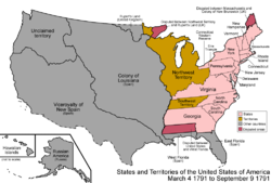 March 4, 1791
The Vermont Republic
, which had portions claimed by New York
and New Hampshire
and, while unrecognized by the United States, was a de facto independent country, was admitted as the 14th state, Vermont
.
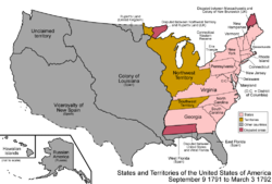 September 9, 1791
The District of Columbia, the nation's federal district
, was formed from land granted by Maryland
and Virginia
; the Virginia portion would be returned
in 1847.
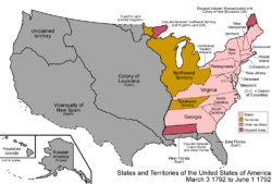 March 3, 1792
The federal government sold the Erie Triangle
to Pennsylvania
.
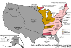 June 1, 1792
The western counties of Virginia
beyond the Appalachian Mountains
were split off and admitted as the 15th state, Kentucky
.
January 11, 1794
In the third Nootka Convention
Spain surrenders its exclusive claim to the entire Pacific Coast and acknowledges the right of Britain or other powers to use unoccupied territory.
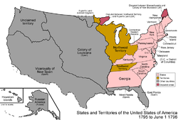 October 27, 1795
Pinckney's Treaty
,
also known as the Treaty of San Lorenzo, signed on October 27, 1795, and proclaimed on August 3, 1796, settles the northern border of West Florida
as the 31st parallel
.
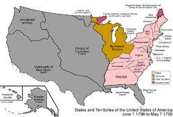 June 1, 1796
The Southwest Territory
was admitted as the 16th state, Tennessee
.
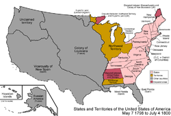 April 7, 1798
Due to the Yazoo Land Fraud, an act was signed by President
John Adams
, authorizing him to appoint commissioners to negotiate with Georgia
about ceding its western land
. The act created Mississippi Territory
in the region ceded by West Florida
, corresponding to roughly the southern third of present-day Mississippi
and Alabama
except their panhandle
s, which were part of West Florida.
 July 4, 1800
Indiana Territory
was formed from the western portion of Northwest Territory
. It corresponded to present-day Illinois
, Indiana
, northeastern Minnesota
, and Wisconsin
, as well as the western half of the Lower Peninsula of Michigan
and all but the eastern tip of the Upper Peninsula. Northwest Territory was left with only most of Ohio
and the rest of Michigan.
 July 10, 1800
Connecticut
ceded its Western Reserve to the federal government, which made it part of Northwest Territory
, and is the northeastern part of present-day Ohio
.
October 1, 1800
The secret Third Treaty of San Ildefonso
transferred the colony of Louisiana
from Spain
to France
. Its boundaries were not specified and control was not actually transferred until the Louisiana Purchase.
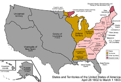 April 26, 1802
Georgia
finally ceded its western claims, the Yazoo Lands
, to the federal government, where it became unorganized land.
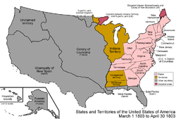 March 1, 1803
The southeastern portion of Northwest Territory
was admitted as the 17th state, Ohio
. The remainder of Northwest Territory was transferred to Indiana Territory
.
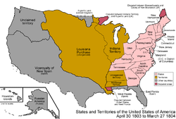 April 30, 1803
The Louisiana Purchase
was made, expanding the United States west of the Mississippi River
. There was a dispute
with West Florida
over how much land east of the Mississippi River
it included. West of the Mississippi, it was defined as the Mississippi Basin, whose extent was not known at the time and extends slightly north of the modern Canada-US border. It consisted of the whole of present-day Arkansas
, Kansas
, Iowa
, Missouri
, Nebraska
, and Oklahoma
, and portions of Colorado
, Louisiana
, Minnesota
, Montana
, New Mexico
, North Dakota
, South Dakota
, Texas
and Wyoming
. It also included the southernmost portions of the present-day Canadian
provinces of Alberta
, Manitoba
, and Saskatchewan
.
 March 27, 1804
The unorganized land ceded by Georgia
was added to Mississippi Territory
, consisting of the whole of present-day Mississippi
and Alabama
, minus their panhandle
s which were still part of West Florida
.
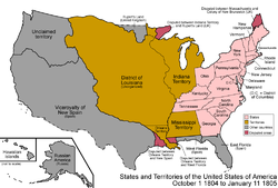 October 1, 1804
The Louisiana Purchase
was split into the District of Louisiana
, which was temporarily under the authority of Indiana Territory
, and the organized Territory of Orleans, which corresponded to part of present-day Louisiana
with a small portion of Texas
. The western border of Orleans Territory caused further conflict with New Spain
, specifically over the region between the Sabine River on the west and the Arroyo Hondo (River)
on the east, which became known as the Sabine Free State
. This land was later confirmed as U.S. territory by the Adams-Onís Treaty
of 1819.
 January 11, 1805
Michigan Territory
was split from Indiana Territory
, including the whole of the lower peninsula of present-day Michigan
but only that eastern tip of the upper peninsula which was held by the Northwest Territory
after Indiana Territory had been split from it.
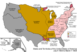 July 4, 1805
The District of Louisiana
was organized as Louisiana Territory
.
 March 1, 1809
Illinois Territory
was split from Indiana Territory
. Illinois Territory included present-day Illinois
, northeastern Minnesota
, and Wisconsin
. Indiana Territory included the present-day borders of Indiana
, with its western and eastern borders continuing northward; thus, it also included the central portion of the upper peninsula of Michigan, as well as Door Peninsula
of present-day Wisconsin
.
 April 1810
The Hawaiian islands are unified as the Kingdom of Hawaii
.
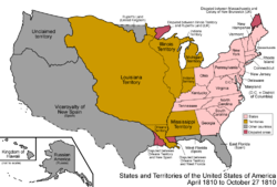
 October 27, 1810
By proclamation by President James Madison
, the United States annexed the Baton Rouge and Mobile District
s of West Florida
, declaring them part of the Louisiana Purchase
. These had, 90 days earlier, declared independence as the Republic of West Florida.
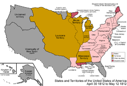 April 30, 1812
Most of the Territory of Orleans was admitted as the 18th state, Louisiana
. The rest of the territory (the northwestern tip) was ceded to Louisiana Territory
.
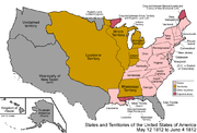 May 12, 1812
The federal government annexed a part of West Florida
, the Mobile District
, to Mississippi Territory
, making the territory correspond to present-day Alabama
and Mississippi
.
 June 4, 1812
Louisiana Territory
, having the same name as a state, was renamed to Missouri Territory
.
April 17, 1813
Republican Army of the North captured San Antonio, Texas
, assassinated the governor Manuel María de Salcedo
, proclaimed Texas an independent nation, and issued Texas's first constitution on this date. Spanish forces recaptured the province later that year and executed any Tejanos accused of having Republican tendencies. By 1820 fewer than 2000 Hispanic citizens remained in Spanish Texas
.
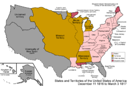 December 11, 1816
The southern portion of Indiana Territory
was admitted as the 19th state, Indiana
. The remainder became unorganized.
 March 3, 1817
Alabama Territory
was split from Mississippi Territory
; both correspond to their present-day counterparts.
 December 10, 1817
Mississippi Territory
was admitted as the 20th state, Mississippi
.
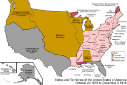 October 20, 1818
The Treaty of 1818
established the 49th parallel north
west of the Lake of the Woods
as the border with British-held lands, and Oregon Country
was established as a shared land between the United States and United Kingdom. Oregon Country consisted of most of present-day Idaho
and Oregon
, all of Washington, and a portion of Montana
, as well as the southern part of the Canadian
province of British Columbia
. The treaty transferred the Red River Basin to the United States, consisting of northwestern Minnesota
, northeastern North Dakota
, and the northeastern tip of South Dakota
.
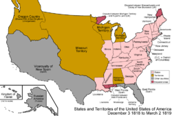 December 3, 1818
The southern portion of Illinois Territory
was admitted as the 21st state, Illinois
. The remainder was reassigned to Michigan Territory
. The unorganized lands which had been a part of Indiana Territory
prior to the admission of Indiana
as a state were also assigned to Michigan Territory.
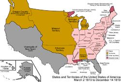 March 2, 1819
The southern part of Missouri Territory
was organized as Arkansaw Territory, consisting of present-day Arkansas
as well as part of Oklahoma
. It was not officially spelled Arkansas until later.
 December 14, 1819
Alabama Territory
was admitted as the 22nd state, Alabama
.
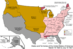 March 16, 1820
The Maine District
of Massachusetts
was split off and admitted as the 23rd state, Maine
, as part of the Missouri Compromise
.
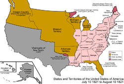 July 10, 1821
The Adams-Onís Treaty
or Transcontinental Treaty came into effect, establishing a defined border between the United States and New Spain
. The treaty ceded Spain's claims to Oregon Country
to the United States and American claims to Texas to Spain; moved portions of present-day Colorado
, Oklahoma
, and Wyoming
, and all of New Mexico
and Texas
, to New Spain; and all of Spanish Florida
to the United States. The new borders intruded on Arkansaw Territory's
Miller County
, created on April 1, 1820, which dipped below the Red River
and into land now ceded to Spain. However, the remoteness of the region caused no serious conflict with Spain.
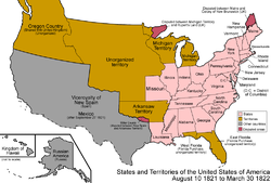 August 10, 1821
The southeastern corner of Missouri Territory
was admitted as the 24th state, Missouri
. The remainder became unorganized. Missouri did not include its northwestern triangle at this point, that being added later in the Platte Purchase
.
September 16, 1821
Ukase of 1821
attempts to forbid non-Russian ships from approaching the Northwest Coast. Only attempt at enforcement is seizure of the U.S. brig Pearl in 1822. U.S. reacts with the Monroe Doctrine
in 1823.
September 27, 1821
The Viceroyalty of New Spain achieved independence as Mexico
. Spanish Texas
became Mexican Texas
.
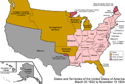 March 30, 1822
East Florida
and the portion of West Florida
not already part of other states were combined and organized as Florida Territory
, which corresponded to present-day Florida
. Around this time, the official spelling of Arkansaw Territory became Arkansas Territory
.
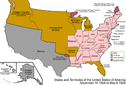 November 15, 1824
Arkansas Territory
was shrunk, the western portion becoming unorganized.
January 12, 1825
Russo-American Treaty of 1824 gave Russia
n claims south of parallel 54°40′ north to the United States. This and the Anglo-Russian Convention of 1825 leave Britain and the U.S. as the only claimants to Oregon Country
. Russia retained Fort Ross, California until 1841.
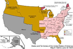 May 6, 1828
Arkansas Territory
was shrunk further, attaining the present-day borders of Arkansas
, with the remainder again becoming unorganized, excepting the land it still claimed as Miller County
.
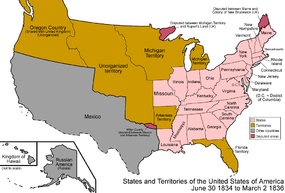 June 30, 1834
A large portion of unorganized land was added to Michigan Territory
, corresponding to present-day Iowa
, western Minnesota
, and eastern North Dakota
and South Dakota
.
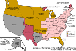 March 2, 1836
The Republic of Texas
achieved independence from Mexico
, though with a large portion of the territory disputed. It had control over the eastern half of present-day Texas
, and disputed the western half, as well as portions of Colorado
, Kansas
, New Mexico
, and Wyoming
. Miller County
in Arkansas Territory
now intruded on the borders of Texas, and the people there began to take a Texian identity, leading to both governments having representatives from the county.
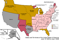 June 15, 1836
Arkansas Territory
was admitted as the 25th state, Arkansas
. It continued to claim Miller County
, with increasing irrelevance.
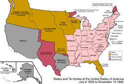
 July 4, 1836
Wisconsin Territory
was split off from Michigan Territory
, consisting of present-day Wisconsin
, Minnesota
, Iowa
, and eastern North
and South Dakota
. As an inducement to give up its claim over the Toledo Strip to Ohio
, the whole of the present-day upper peninsula
was assigned to Michigan Territory, giving it the present-day borders of Michigan
.
 January 26, 1837
Michigan Territory
was admitted as the 26th state, Michigan
.
 March 28, 1837
The Platte Purchase
added a small area of land to Missouri
, giving it its present-day boundaries.
 July 4, 1838
Iowa Territory
was split off from Wisconsin Territory
, consisting of present-day Iowa
, western Minnesota
, and eastern North Dakota
and South Dakota
, leaving Wisconsin Territory with northeastern Minnesota and Wisconsin
.
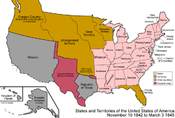 November 10, 1842
The Webster-Ashburton Treaty
settled the border between the United States and lands held by the United Kingdom east of the Rocky Mountains
, ending the disputes over the northern border of the state of Maine
and northeastern border of Wisconsin Territory
, which today resides in present day Minnesota
.
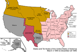 March 3, 1845
Florida Territory
was admitted as the 27th state, Florida
.
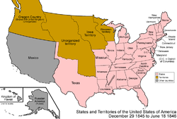 December 29, 1845
The Republic of Texas
was admitted as the 28th state, Texas
. The United States Congress
passed the joint resolution of annexation
on March 1, 1845, but Texas did not agree to join the union for some time after. Although the annexation resolution avoided specifying Texas's boundaries, the U.S. inherited Texas's unenforced claims to South Texas
, West Texas
, over half of New Mexico
, a third of Colorado
, and small parts of Oklahoma
, Kansas
and Wyoming
. With Texas joining the union, Arkansas
finally gave up its claim on Miller County
.
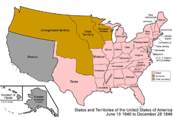 June 18, 1846
The Oregon Treaty
established the 49th parallel
west of the Lake of the Woods as the continental border (so it did not include Vancouver Island
) with the lands held by the United Kingdom. The sharing of Oregon Country
ended, and the American portion becomes unorganized territory.
August 15, 1846
U.S. Army of the West (1846)
under Stephen Kearny captures New Mexico and claims it for the U.S.
He installs a U.S. military government of New Mexico under the Kearny Code
and later a provisional government of New Mexico, subject to the federal government and not to Texas.
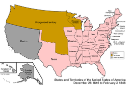 December 28, 1846
The southeast portion of Iowa Territory
was admitted as the 29th state, Iowa
. The remainder became unorganized.
January 13, 1847
Californio
resistance to U.S. forces in California
ended with the Treaty of Cahuenga
.
March 13, 1847
The District of Columbia retroceded
its land south of the Potomac River
back to Virginia
. Congress passed the retrocession act on July 9, 1846, and Virginia took possession of the land on this date.
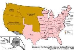
 February 2, 1848
The Treaty of Guadalupe Hidalgo
ended the Mexican-American War. Mexico ceded the Texas-claimed areas as well as a large area of land
consisting of all of present-day California
, Nevada
, and Utah
, most of Arizona
, and portions of Colorado
, New Mexico
, and Wyoming
.
 May 29, 1848
The southeastern portion of Wisconsin Territory
was admitted as the 30th state, Wisconsin
. The remainder became unorganized.
 August 14, 1848
Oregon Territory
was organized, including present-day Idaho
, northwestern Montana
, Oregon
, Washington, and western Wyoming
.
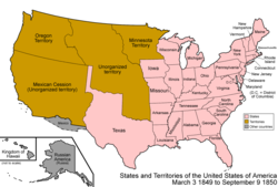 March 3, 1849
Minnesota Territory
was organized, consisting of present-day Minnesota
, and eastern portions of North Dakota
and South Dakota
.
 September 9, 1850
The Compromise of 1850
divided the Mexican Cession
and land claimed by Texas
but ceded to the federal government in exchange for taking on its debts. The western portion was admitted as the 31st state, California
, most of the rest was organized as Utah Territory
and New Mexico Territory
, and a small portion became unorganized land. New Mexico Territory consisted of most of present-day Arizona
and New Mexico
, as well as a southern portion of Colorado
and the southern tip of Nevada
. Utah Territory consisted of present-day Utah
, most of Nevada, and portions of Colorado and Wyoming
. A peculiarity appeared at this time, when a small strip of land north of Texas was not officially assigned by any state or territory; this came to be called the Neutral Strip or "No Man's Land", which corresponds to the present-day panhandle
of Oklahoma
.
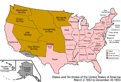 March 2, 1853
Washington Territory
was split from Oregon Territory
, consisting of present-day Washington, northern Idaho
, and the western tip of Montana
, leaving Oregon Territory with all of Oregon
, southern Idaho and a portion of Wyoming
.
 December 30, 1853
The Gadsden Purchase
added some land to New Mexico Territory
, corresponding to the southernmost areas of present-day Arizona
and New Mexico
. The present-day Continental United States borders were defined at this point.
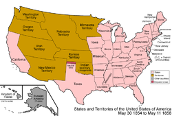 May 30, 1854
Kansas Territory
and Nebraska Territory
were organized; the remaining unorganized land colloquially became known as Indian Territory
. Kansas Territory consisted of present-day Kansas
and eastern Colorado
. Nebraska Territory consisted of present-day Nebraska
, and parts of Colorado
, Montana
, North Dakota
, South Dakota
, and Wyoming
. Indian Territory corresponds to eastern Oklahoma
.
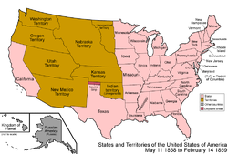 May 11, 1858
The eastern portion of Minnesota Territory
was admitted as the 32nd state, Minnesota
. The remainder became unorganized.
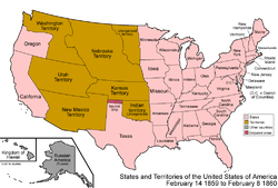 February 14, 1859
The western portion of Oregon Territory
was admitted as the 33rd state, Oregon
. The remainder was assigned to Washington Territory
.
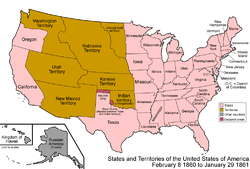 February 8, 1860
Texas began claiming Greer County, Texas
, controlled at that time by the federal government as unorganized territory, and now in present-day Oklahoma
.
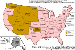 January 29, 1861
The eastern portion of Kansas Territory
was admitted as the 34th state, Kansas
. A peculiarity arose for the western portion. It was added to Colorado Territory
on February 28, 1861; however, for the month between statehood for Kansas and the Colorado Territory being formed, it appears to have had no official status.
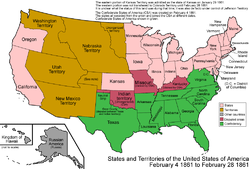 February 4, 1861
The Confederate States of America
(CSA) was formed. The Southern states
seceded
at different dates and joined the CSA at different dates; to simplify the map, only the final form of the CSA is shown here. There were rebel governments
as well as Union
governments in Kentucky
and Missouri
, and the CSA had full control over Indian Territory
. To view a detailed animated map depicting the various state secessions see CSA states evolution.
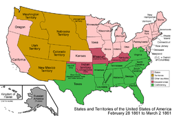 February 28, 1861
Colorado Territory
was organized, with land from Utah
, New Mexico
, and Nebraska
Territories, as well as the land left over from Kansas Territory
; it corresponded already to present-day Colorado
. Also, the eastern tip of Washington Territory
was transferred to Nebraska Territory
.
 March 2, 1861
Dakota Territory
was split from Nebraska Territory
, and included the unorganized land left over from Minnesota Territory
. Dakota Territory consisted of both present-day North
and South Dakota
, as well as most of Montana
and northern Wyoming
. Nebraska Territory consisted of all of Nebraska
and southeastern Wyoming. Nevada Territory
was split from Utah Territory
, corresponding to northwestern present-day Nevada
; the eastern border was the 39th meridian west of Washington, D.C.
 August 1, 1861
The Confederacy
established Arizona Territory (CSA)
in the southern half of the Union's New Mexico Territory
. It would be organized on February 14, 1862. It corresponded to the southern halves of present-day Arizona
and New Mexico
.
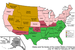 July 14, 1862
Due to its nature as a mining and grazing area, land started to be added to Nevada Territory
to accommodate these activities. Its eastern border was moved eastward from the 39th meridian west from Washington
, to the 38th meridian west from Washington, transferring the land from Utah Territory
.
 February 24, 1863
The Union created its own Arizona Territory
, splitting it off from New Mexico Territory
, making both territories correspond to their present-day states, except for Arizona Territory including the southern tip of present-day Nevada
.
 March 4, 1863
Idaho Territory
was created from portions of Washington
, Dakota
, and Nebraska
Territories, consisting of present-day Idaho
, Montana
, and most of Wyoming
. Nebraska and Washington Territories were left corresponding to their present-day counterparts.
 June 20, 1863
The counties of northwestern Virginia
(whose population had opposed secession from the Union and established a pro-Union state government
) were split off and were admitted as the 35th state, West Virginia
. The new state had been mostly under Union control since late 1861, but is not recognized by the Confederate
and state governments in Richmond.
 May 26, 1864
Montana Territory
was split from Idaho Territory
, which also had some land transferred to Dakota Territory
. Montana Territory corresponded to present-day Montana
, Idaho Territory consisted of Idaho
and western Wyoming
, and Dakota Territory included both North
and South Dakota
, and most of Wyoming.
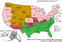 October 31, 1864
Nevada Territory
was admitted as the 36th state, Nevada
; it was a bit smaller than it is today, lacking area in both the east and south.
 April 9, 1865
The main army
of the Confederate States of America
surrendered
, and the Confederacy dissolved soon afterward. Much of the Confederate States' territory had already been retaken by force of arms prior to this point and the process of Reconstruction and readmission to the union would take several years following the Confederacy's collapse; to simplify the map, the former Confederate states are shown as already readmitted. To view a detailed animated map depicting the various state readmission during Reconstruction see CSA states evolution.
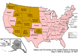 May 5, 1866
Nevada
's eastern border was moved from the 38th meridian west from Washington
, to the 37th meridian west from Washington, transferring land to it from Utah Territory
.
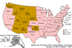 January 18, 1867
The northwestern corner of Arizona Territory
was transferred to the state of Nevada
, giving it its present-day borders.
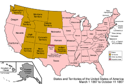 March 1, 1867
Nebraska Territory
was admitted as the 37th state, Nebraska
.
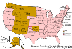 October 11, 1867
The United States purchased Alaska
from Russia
; it was designated the Department of Alaska
, and corresponds, except for a boundary dispute
, to present-day Alaska
.
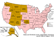 July 25, 1868
Wyoming Territory
was formed from portions of Dakota
, Idaho
, and Utah
Territories, corresponding to the present-day borders of Wyoming
.
 October 21, 1872
San Juan Islands
awarded to the U.S., formally ending the Pig War
with Britain.
August 1, 1876
Colorado Territory
was admitted as the 38th state, Colorado
.
The part of Dakota Territory
south of 43° north and north of the Keya Paha
and Niobrara
Rivers was transferred to Nebraska
.
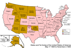 May 17, 1884
The Department of Alaska
, previously under the direct control of the federal government and the military, was redesignated the District of Alaska
, forming a local government.
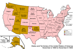 November 2, 1889
Dakota Territory
was split in two, and it was admitted as the 39th state, North Dakota
, and 40th state, South Dakota
.
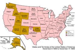 November 8, 1889
Montana Territory
was admitted as the 41st state, Montana
.
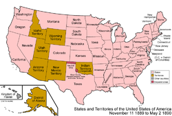 November 11, 1889
Washington Territory
was admitted as the 42nd state, Washington.
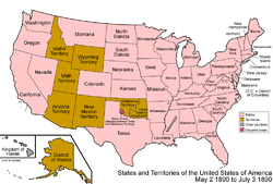 May 2, 1890
Oklahoma Territory
was organized from the western portion of Indian Territory
, and included the Neutral Strip, and corresponded to the western half of present-day Oklahoma
.
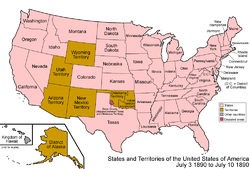 July 3, 1890
Idaho Territory
was admitted as the 43rd state, Idaho
.
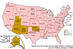 July 10, 1890
Wyoming Territory
was admitted as the 44th state, Wyoming
.
July 4, 1894
The Kingdom of Hawaii
became the Republic of Hawaii
.
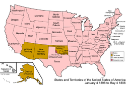 January 4, 1896
Utah Territory
was admitted as the 45th state, Utah
.
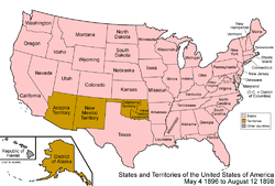 May 4, 1896
A Supreme Court
ruling officially assigns Greer County
to Oklahoma Territory
.
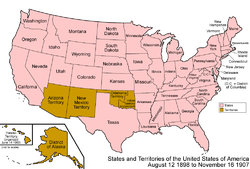 August 12, 1898
The Republic of Hawaii
was annexed by the United States.
The annexed Hawaiian islands were organized as the Territory of Hawaii
, and corresponded, except for including Palmyra Atoll
, to the present-day state of Hawaii
.
October 20, 1903
The Alaska boundary dispute
is resolved by arbitration, generally favoring the American claim.
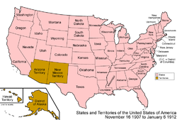 November 16, 1907
Oklahoma Territory
and Indian Territory
were combined and admitted as the 46th state, Oklahoma
.
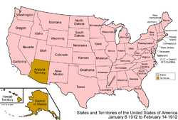 January 6, 1912
New Mexico Territory
was admitted as the 47th state, New Mexico
.
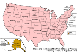 February 14, 1912
Arizona Territory
was admitted as the 48th state, Arizona
.
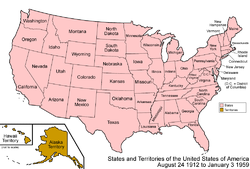 August 24, 1912
The District of Alaska
was organized as Alaska Territory
.
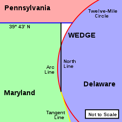 March 28, 1921
The dispute over a square mile between Delaware
and Pennsylvania
, The Wedge
, is finally resolved in favor of Delaware.
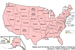 January 3, 1959
Alaska Territory
was admitted as the 49th state, Alaska
.
 August 21, 1959
Hawaii Territory
was admitted as the 50th state, Hawaii
, resulting in the present-day situation of the United States. The statehood act specifically excluded Palmyra Atoll
from the new state; it thus became unorganized land. Since it had been incorporated as part of the Hawaii Territory, Palmyra Atoll became the only incorporated territory left in the United States.
January 14, 1963
The Chamizal Dispute
with Mexico over about 600 acres (2.4 km2) on the U.S.-Mexico border between El Paso, Texas, and Ciudad Juárez, Chihuahua is resolved. It was caused by differences between the bed of the Rio Grande as surveyed in 1852 and the present channel of the river.
1970
The city of Rio Rico, Texas
, was ceded to Mexico
in the Boundary Treaty of 1970
. The handover officially took place in 1977 and the city was added to the Mexican state of Tamaulipas
.
Border
Borders define geographic boundaries of political entities or legal jurisdictions, such as governments, sovereign states, federated states and other subnational entities. Some borders—such as a state's internal administrative borders, or inter-state borders within the Schengen Area—are open and...
s of the United States
United States
The United States of America is a federal constitutional republic comprising fifty states and a federal district...
. This lists each change to the internal and external borders of the country, as well as status and name changes. It also shows the surrounding areas that eventually became part of the United States. Each stage has a map, to show what the specific makeup of the country was at any given time.
After achieving independence with the Treaty of Paris
Treaty of Paris (1783)
The Treaty of Paris, signed on September 3, 1783, ended the American Revolutionary War between Great Britain on the one hand and the United States of America and its allies on the other. The other combatant nations, France, Spain and the Dutch Republic had separate agreements; for details of...
, the United States expanded westward, enlarging its borders seven times, with two major border adjustments, one each with colonies of the United Kingdom
United Kingdom
The United Kingdom of Great Britain and Northern IrelandIn the United Kingdom and Dependencies, other languages have been officially recognised as legitimate autochthonous languages under the European Charter for Regional or Minority Languages...
and Spain
Spain
Spain , officially the Kingdom of Spain languages]] under the European Charter for Regional or Minority Languages. In each of these, Spain's official name is as follows:;;;;;;), is a country and member state of the European Union located in southwestern Europe on the Iberian Peninsula...
, and several small disputes. The original thirteen states grew into fifty states
U.S. state
A U.S. state is any one of the 50 federated states of the United States of America that share sovereignty with the federal government. Because of this shared sovereignty, an American is a citizen both of the federal entity and of his or her state of domicile. Four states use the official title of...
, most of which began as incorporated territories
Incorporated territory
Territories of the United States are one of the four types of political division of the United States, overseen directly by the federal government of the United States and not any part of a U.S. state. These territories were created to govern newly acquired land while the borders of the United...
. The general pattern seen in this is of territorial expansion, carving of organized territories from the newly acquired land, modification of the borders of these territories, and eventual statehood. Only two states, Nevada
Nevada
Nevada is a state in the western, mountain west, and southwestern regions of the United States. With an area of and a population of about 2.7 million, it is the 7th-largest and 35th-most populous state. Over two-thirds of Nevada's people live in the Las Vegas metropolitan area, which contains its...
and Missouri
Missouri
Missouri is a US state located in the Midwestern United States, bordered by Iowa, Illinois, Kentucky, Tennessee, Arkansas, Oklahoma, Kansas and Nebraska. With a 2010 population of 5,988,927, Missouri is the 18th most populous state in the nation and the fifth most populous in the Midwest. It...
, grew appreciably after statehood, and five, Georgia
Georgia (U.S. state)
Georgia is a state located in the southeastern United States. It was established in 1732, the last of the original Thirteen Colonies. The state is named after King George II of Great Britain. Georgia was the fourth state to ratify the United States Constitution, on January 2, 1788...
, Massachusetts
Massachusetts
The Commonwealth of Massachusetts is a state in the New England region of the northeastern United States of America. It is bordered by Rhode Island and Connecticut to the south, New York to the west, and Vermont and New Hampshire to the north; at its east lies the Atlantic Ocean. As of the 2010...
, North Carolina
North Carolina
North Carolina is a state located in the southeastern United States. The state borders South Carolina and Georgia to the south, Tennessee to the west and Virginia to the north. North Carolina contains 100 counties. Its capital is Raleigh, and its largest city is Charlotte...
, Texas
Texas
Texas is the second largest U.S. state by both area and population, and the largest state by area in the contiguous United States.The name, based on the Caddo word "Tejas" meaning "friends" or "allies", was applied by the Spanish to the Caddo themselves and to the region of their settlement in...
, and Virginia
Virginia
The Commonwealth of Virginia , is a U.S. state on the Atlantic Coast of the Southern United States. Virginia is nicknamed the "Old Dominion" and sometimes the "Mother of Presidents" after the eight U.S. presidents born there...
, lost land, in each case to form new states.
18th century
The United States Constitution
United States Constitution
The Constitution of the United States is the supreme law of the United States of America. It is the framework for the organization of the United States government and for the relationship of the federal government with the states, citizens, and all people within the United States.The first three...
came into effect, forming the new nation. Note that the states ratified at different times, but to simplify the map, the final result is shown here.
The United States achieved independence from the Kingdom of Great Britain
Kingdom of Great Britain
The former Kingdom of Great Britain, sometimes described as the 'United Kingdom of Great Britain', That the Two Kingdoms of Scotland and England, shall upon the 1st May next ensuing the date hereof, and forever after, be United into One Kingdom by the Name of GREAT BRITAIN. was a sovereign...
with the Treaty of Paris
Treaty of Paris (1783)
The Treaty of Paris, signed on September 3, 1783, ended the American Revolutionary War between Great Britain on the one hand and the United States of America and its allies on the other. The other combatant nations, France, Spain and the Dutch Republic had separate agreements; for details of...
on September 3, 1783, which established that the thirteen colonies were sovereign and independent states. The borders were established by Article 2 of the treaty, but with a couple of issues. First, it stated that the border would run west from the Lake of the Woods
Lake of the Woods
Lake of the Woods is a lake occupying parts of the Canadian provinces of Ontario and Manitoba and the U.S. state of Minnesota. It separates a small land area of Minnesota from the rest of the United States. The Northwest Angle and the town of Angle Township can only be reached from the rest of...
to the Mississippi River
Mississippi River
The Mississippi River is the largest river system in North America. Flowing entirely in the United States, this river rises in western Minnesota and meanders slowly southwards for to the Mississippi River Delta at the Gulf of Mexico. With its many tributaries, the Mississippi's watershed drains...
- at the time, it was not known that the headwaters of the Mississippi lay south of such a line, so the border has since been taken to run south from the lake to the river.
Some peculiarities to point out to those familiar only with the current borders: Many states had sea-to-sea grants from the British crown that they would not give up easily, so prior to this date, they ceded this land
State cessions
The state cessions are those areas of the United States that the separate states ceded to the federal government in the late 18th and early 19th century...
to the federal government in exchange for their Revolutionary War
American Revolutionary War
The American Revolutionary War , the American War of Independence, or simply the Revolutionary War, began as a war between the Kingdom of Great Britain and thirteen British colonies in North America, and ended in a global war between several European great powers.The war was the result of the...
debts. However, Georgia
Georgia (U.S. state)
Georgia is a state located in the southeastern United States. It was established in 1732, the last of the original Thirteen Colonies. The state is named after King George II of Great Britain. Georgia was the fourth state to ratify the United States Constitution, on January 2, 1788...
did not do so until much later, and Connecticut
Connecticut
Connecticut is a state in the New England region of the northeastern United States. It is bordered by Rhode Island to the east, Massachusetts to the north, and the state of New York to the west and the south .Connecticut is named for the Connecticut River, the major U.S. river that approximately...
ceded most land but kept its Western Reserve. Virginia ceded its claim to the territory north and west of the Ohio River
Ohio River
The Ohio River is the largest tributary, by volume, of the Mississippi River. At the confluence, the Ohio is even bigger than the Mississippi and, thus, is hydrologically the main stream of the whole river system, including the Allegheny River further upstream...
, and this land became unorganized territory
Unorganized territory
An unorganized territory is a region of land without a "normally" constituted system of government. This does not mean that the territory has no government at all or that it is unclaimed territory...
. North Carolina
North Carolina
North Carolina is a state located in the southeastern United States. The state borders South Carolina and Georgia to the south, Tennessee to the west and Virginia to the north. North Carolina contains 100 counties. Its capital is Raleigh, and its largest city is Charlotte...
also ceded its claim to its western counties, but this was not officially accepted by Congress until 1790. New York
New York
New York is a state in the Northeastern region of the United States. It is the nation's third most populous state. New York is bordered by New Jersey and Pennsylvania to the south, and by Connecticut, Massachusetts and Vermont to the east...
ceded its claim on the Erie Triangle
Erie Triangle
The Erie Triangle is a tract of American land that was the subject of several competing colonial-era claims and which was eventually acquired by the U.S. federal government and sold to Pennsylvania so that the state would have access to a freshwater port on Lake Erie...
to the federal government. At this point in history, all of the states except for Georgia and Virginia were at their present-day borders, except for some of the minor issues mentioned above.
West Florida
West Florida
West Florida was a region on the north shore of the Gulf of Mexico, which underwent several boundary and sovereignty changes during its history. West Florida was first established in 1763 by the British government; as its name suggests it largely consisted of the western portion of the region...
claimed a border further north than what the United States said it had. Its border had been 31° north when Spain ceded it to the United Kingdom
United Kingdom
The United Kingdom of Great Britain and Northern IrelandIn the United Kingdom and Dependencies, other languages have been officially recognised as legitimate autochthonous languages under the European Charter for Regional or Minority Languages...
. The British later moved its border north to 32°38′ latitude, but when Spanish Florida
Spanish Florida
Spanish Florida refers to the Spanish territory of Florida, which formed part of the Captaincy General of Cuba, the Viceroyalty of New Spain, and the Spanish Empire. Originally extending over what is now the southeastern United States, but with no defined boundaries, la Florida was a component of...
was ceded back to Spain
Spanish Empire
The Spanish Empire comprised territories and colonies administered directly by Spain in Europe, in America, Africa, Asia and Oceania. It originated during the Age of Exploration and was therefore one of the first global empires. At the time of Habsburgs, Spain reached the peak of its world power....
in the Treaty of Paris
Treaty of Paris (1783)
The Treaty of Paris, signed on September 3, 1783, ended the American Revolutionary War between Great Britain on the one hand and the United States of America and its allies on the other. The other combatant nations, France, Spain and the Dutch Republic had separate agreements; for details of...
, the British cited the original border at the 31st parallel north
31st parallel north
The 31st parallel north is a circle of latitude that is 31 degrees north of the Earth's equatorial plane. It crosses Africa, Asia, the Pacific Ocean, North America and the Atlantic Ocean.Part of the border between Iran and Iraq is defined by the parallel....
, but Spain continued to claim the higher border. Also, the borders at the northern area of the Maine District of Massachusetts
Massachusetts
The Commonwealth of Massachusetts is a state in the New England region of the northeastern United States of America. It is bordered by Rhode Island and Connecticut to the south, New York to the west, and Vermont and New Hampshire to the north; at its east lies the Atlantic Ocean. As of the 2010...
and the area northwest of Lake Superior
Lake Superior
Lake Superior is the largest of the five traditionally-demarcated Great Lakes of North America. It is bounded to the north by the Canadian province of Ontario and the U.S. state of Minnesota, and to the south by the U.S. states of Wisconsin and Michigan. It is the largest freshwater lake in the...
remained disputed.
The Wedge
The Wedge (border)
The Wedge is a small tract of land along the borders of Delaware, Maryland and Pennsylvania. Ownership of the land was disputed until 1921; it is now recognized as part of Delaware. The tract was created primarily due to the shortcomings of contemporary surveying techniques...
, disputed since the 17th century, remained a point of contention between Delaware
Delaware
Delaware is a U.S. state located on the Atlantic Coast in the Mid-Atlantic region of the United States. It is bordered to the south and west by Maryland, and to the north by Pennsylvania...
and Pennsylvania
Pennsylvania
The Commonwealth of Pennsylvania is a U.S. state that is located in the Northeastern and Mid-Atlantic regions of the United States. The state borders Delaware and Maryland to the south, West Virginia to the southwest, Ohio to the west, New York and Ontario, Canada, to the north, and New Jersey to...
.
The Vermont Republic
Vermont Republic
The term Vermont Republic has been used by later historians for the government of what became modern Vermont from 1777 to 1791. In July 1777 delegates from 28 towns met and declared independence from jurisdictions and land claims of British colonies in New Hampshire and New York. They also...
was a complex matter, with areas being claimed by New York
New York
New York is a state in the Northeastern region of the United States. It is the nation's third most populous state. New York is bordered by New Jersey and Pennsylvania to the south, and by Connecticut, Massachusetts and Vermont to the east...
and New Hampshire
New Hampshire
New Hampshire is a state in the New England region of the northeastern United States of America. The state was named after the southern English county of Hampshire. It is bordered by Massachusetts to the south, Vermont to the west, Maine and the Atlantic Ocean to the east, and the Canadian...
, but it existed as a de facto
De facto
De facto is a Latin expression that means "concerning fact." In law, it often means "in practice but not necessarily ordained by law" or "in practice or actuality, but not officially established." It is commonly used in contrast to de jure when referring to matters of law, governance, or...
unrecognized independent state.
The United States Congress affirmed the organization of the Territory North West of the Ohio River, or Northwest Territory
Northwest Territory
The Territory Northwest of the River Ohio, more commonly known as the Northwest Territory, was an organized incorporated territory of the United States that existed from July 13, 1787, until March 1, 1803, when the southeastern portion of the territory was admitted to the Union as the state of Ohio...
, under the terms of the Northwest Ordinance
Northwest Ordinance
The Northwest Ordinance was an act of the Congress of the Confederation of the United States, passed July 13, 1787...
. Northwest Territory consisted of present-day Illinois
Illinois
Illinois is the fifth-most populous state of the United States of America, and is often noted for being a microcosm of the entire country. With Chicago in the northeast, small industrial cities and great agricultural productivity in central and northern Illinois, and natural resources like coal,...
, Indiana
Indiana
Indiana is a US state, admitted to the United States as the 19th on December 11, 1816. It is located in the Midwestern United States and Great Lakes Region. With 6,483,802 residents, the state is ranked 15th in population and 16th in population density. Indiana is ranked 38th in land area and is...
, Michigan
Michigan
Michigan is a U.S. state located in the Great Lakes Region of the United States of America. The name Michigan is the French form of the Ojibwa word mishigamaa, meaning "large water" or "large lake"....
, northeastern Minnesota
Minnesota
Minnesota is a U.S. state located in the Midwestern United States. The twelfth largest state of the U.S., it is the twenty-first most populous, with 5.3 million residents. Minnesota was carved out of the eastern half of the Minnesota Territory and admitted to the Union as the thirty-second state...
, most of Ohio
Ohio
Ohio is a Midwestern state in the United States. The 34th largest state by area in the U.S.,it is the 7th‑most populous with over 11.5 million residents, containing several major American cities and seven metropolitan areas with populations of 500,000 or more.The state's capital is Columbus...
, and Wisconsin
Wisconsin
Wisconsin is a U.S. state located in the north-central United States and is part of the Midwest. It is bordered by Minnesota to the west, Iowa to the southwest, Illinois to the south, Lake Michigan to the east, Michigan to the northeast, and Lake Superior to the north. Wisconsin's capital is...
. The Northwest Territory had previously been organized under the Articles of Confederation
Articles of Confederation
The Articles of Confederation, formally the Articles of Confederation and Perpetual Union, was an agreement among the 13 founding states that legally established the United States of America as a confederation of sovereign states and served as its first constitution...
on July 13, 1787, and was slightly modified under the new Constitution.
Congress accepts North Carolina
North Carolina
North Carolina is a state located in the southeastern United States. The state borders South Carolina and Georgia to the south, Tennessee to the west and Virginia to the north. North Carolina contains 100 counties. Its capital is Raleigh, and its largest city is Charlotte...
's cession of its western counties, which had initially been ceded on December 22, 1789. The land became unorganized territory.
The Southwest Ordinance organized the Territory South of the Ohio River, or Southwest Territory
Southwest Territory
The Territory South of the River Ohio, more commonly known as the Southwest Territory, was an organized incorporated territory of the United States that existed from May 26, 1790, until June 1, 1796, when it was admitted to the United States as the State of Tennessee.The Southwest Territory was...
, which corresponded to present-day Tennessee
Tennessee
Tennessee is a U.S. state located in the Southeastern United States. It has a population of 6,346,105, making it the nation's 17th-largest state by population, and covers , making it the 36th-largest by total land area...
.
The Vermont Republic
Vermont Republic
The term Vermont Republic has been used by later historians for the government of what became modern Vermont from 1777 to 1791. In July 1777 delegates from 28 towns met and declared independence from jurisdictions and land claims of British colonies in New Hampshire and New York. They also...
, which had portions claimed by New York
New York
New York is a state in the Northeastern region of the United States. It is the nation's third most populous state. New York is bordered by New Jersey and Pennsylvania to the south, and by Connecticut, Massachusetts and Vermont to the east...
and New Hampshire
New Hampshire
New Hampshire is a state in the New England region of the northeastern United States of America. The state was named after the southern English county of Hampshire. It is bordered by Massachusetts to the south, Vermont to the west, Maine and the Atlantic Ocean to the east, and the Canadian...
and, while unrecognized by the United States, was a de facto independent country, was admitted as the 14th state, Vermont
Vermont
Vermont is a state in the New England region of the northeastern United States of America. The state ranks 43rd in land area, , and 45th in total area. Its population according to the 2010 census, 630,337, is the second smallest in the country, larger only than Wyoming. It is the only New England...
.
The District of Columbia, the nation's federal district
Federal district
Federal districts are a type of administrative division of a federation, under the direct control of a federal government. They exist in various countries and states all over the world.-United States:...
, was formed from land granted by Maryland
Maryland
Maryland is a U.S. state located in the Mid Atlantic region of the United States, bordering Virginia, West Virginia, and the District of Columbia to its south and west; Pennsylvania to its north; and Delaware to its east...
and Virginia
Virginia
The Commonwealth of Virginia , is a U.S. state on the Atlantic Coast of the Southern United States. Virginia is nicknamed the "Old Dominion" and sometimes the "Mother of Presidents" after the eight U.S. presidents born there...
; the Virginia portion would be returned
Retrocession (District of Columbia)
District of Columbia retrocession is the process of returning the land that was given to the federal government for the original purpose of creating the national capital. The District of Columbia was formed in 1791 from of land ceded by the states of Maryland and Virginia in accordance with the...
in 1847.
The federal government sold the Erie Triangle
Erie Triangle
The Erie Triangle is a tract of American land that was the subject of several competing colonial-era claims and which was eventually acquired by the U.S. federal government and sold to Pennsylvania so that the state would have access to a freshwater port on Lake Erie...
to Pennsylvania
Pennsylvania
The Commonwealth of Pennsylvania is a U.S. state that is located in the Northeastern and Mid-Atlantic regions of the United States. The state borders Delaware and Maryland to the south, West Virginia to the southwest, Ohio to the west, New York and Ontario, Canada, to the north, and New Jersey to...
.
The western counties of Virginia
Virginia
The Commonwealth of Virginia , is a U.S. state on the Atlantic Coast of the Southern United States. Virginia is nicknamed the "Old Dominion" and sometimes the "Mother of Presidents" after the eight U.S. presidents born there...
beyond the Appalachian Mountains
Appalachian Mountains
The Appalachian Mountains #Whether the stressed vowel is or ,#Whether the "ch" is pronounced as a fricative or an affricate , and#Whether the final vowel is the monophthong or the diphthong .), often called the Appalachians, are a system of mountains in eastern North America. The Appalachians...
were split off and admitted as the 15th state, Kentucky
Kentucky
The Commonwealth of Kentucky is a state located in the East Central United States of America. As classified by the United States Census Bureau, Kentucky is a Southern state, more specifically in the East South Central region. Kentucky is one of four U.S. states constituted as a commonwealth...
.
January 11, 1794
In the third Nootka Convention
Nootka Convention
The Nootka Conventions were a series of three agreements between the Kingdom of Spain and the Kingdom of Great Britain, signed in the 1790s which averted a war between the two empires over overlapping claims to portions of the Pacific Northwest coast of North America.The claims of Spain dated back...
Spain surrenders its exclusive claim to the entire Pacific Coast and acknowledges the right of Britain or other powers to use unoccupied territory.
Pinckney's Treaty
Pinckney's Treaty
Pinckney's Treaty, also known as the Treaty of San Lorenzo or the Treaty of Madrid, was signed in San Lorenzo de El Escorial on October 27, 1795 and established intentions of friendship between the United States and Spain. It also defined the boundaries of the United States with the Spanish...
,
also known as the Treaty of San Lorenzo, signed on October 27, 1795, and proclaimed on August 3, 1796, settles the northern border of West Florida
West Florida
West Florida was a region on the north shore of the Gulf of Mexico, which underwent several boundary and sovereignty changes during its history. West Florida was first established in 1763 by the British government; as its name suggests it largely consisted of the western portion of the region...
as the 31st parallel
31st parallel north
The 31st parallel north is a circle of latitude that is 31 degrees north of the Earth's equatorial plane. It crosses Africa, Asia, the Pacific Ocean, North America and the Atlantic Ocean.Part of the border between Iran and Iraq is defined by the parallel....
.
The Southwest Territory
Southwest Territory
The Territory South of the River Ohio, more commonly known as the Southwest Territory, was an organized incorporated territory of the United States that existed from May 26, 1790, until June 1, 1796, when it was admitted to the United States as the State of Tennessee.The Southwest Territory was...
was admitted as the 16th state, Tennessee
Tennessee
Tennessee is a U.S. state located in the Southeastern United States. It has a population of 6,346,105, making it the nation's 17th-largest state by population, and covers , making it the 36th-largest by total land area...
.
Due to the Yazoo Land Fraud, an act was signed by President
President of the United States
The President of the United States of America is the head of state and head of government of the United States. The president leads the executive branch of the federal government and is the commander-in-chief of the United States Armed Forces....
John Adams
John Adams
John Adams was an American lawyer, statesman, diplomat and political theorist. A leading champion of independence in 1776, he was the second President of the United States...
, authorizing him to appoint commissioners to negotiate with Georgia
Georgia (U.S. state)
Georgia is a state located in the southeastern United States. It was established in 1732, the last of the original Thirteen Colonies. The state is named after King George II of Great Britain. Georgia was the fourth state to ratify the United States Constitution, on January 2, 1788...
about ceding its western land
Yazoo lands
The Yazoo lands were the sparsely-populated central and western areas of the U.S. state of Georgia, when its western border stretched back to the Mississippi River. It was named for the Yazoo tribe of Native Americans. Several other places and things were named Yazoo, either for or along with the...
. The act created Mississippi Territory
Mississippi Territory
The Territory of Mississippi was an organized incorporated territory of the United States that existed from April 7, 1798, until December 10, 1817, when the final extent of the territory was admitted to the Union as the state of Mississippi....
in the region ceded by West Florida
West Florida
West Florida was a region on the north shore of the Gulf of Mexico, which underwent several boundary and sovereignty changes during its history. West Florida was first established in 1763 by the British government; as its name suggests it largely consisted of the western portion of the region...
, corresponding to roughly the southern third of present-day Mississippi
Mississippi
Mississippi is a U.S. state located in the Southern United States. Jackson is the state capital and largest city. The name of the state derives from the Mississippi River, which flows along its western boundary, whose name comes from the Ojibwe word misi-ziibi...
and Alabama
Alabama
Alabama is a state located in the southeastern region of the United States. It is bordered by Tennessee to the north, Georgia to the east, Florida and the Gulf of Mexico to the south, and Mississippi to the west. Alabama ranks 30th in total land area and ranks second in the size of its inland...
except their panhandle
Panhandle
A panhandle is an informal geographic term for an elongated arm-like protrusion of a geo-political entity, such as a subnational entity or a sovereign state.-Term:...
s, which were part of West Florida.
1800s
Indiana Territory
Indiana Territory
The Territory of Indiana was an organized incorporated territory of the United States that existed from July 4, 1800, until November 7, 1816, when the southern portion of the territory was admitted to the Union as the state of Indiana....
was formed from the western portion of Northwest Territory
Northwest Territory
The Territory Northwest of the River Ohio, more commonly known as the Northwest Territory, was an organized incorporated territory of the United States that existed from July 13, 1787, until March 1, 1803, when the southeastern portion of the territory was admitted to the Union as the state of Ohio...
. It corresponded to present-day Illinois
Illinois
Illinois is the fifth-most populous state of the United States of America, and is often noted for being a microcosm of the entire country. With Chicago in the northeast, small industrial cities and great agricultural productivity in central and northern Illinois, and natural resources like coal,...
, Indiana
Indiana
Indiana is a US state, admitted to the United States as the 19th on December 11, 1816. It is located in the Midwestern United States and Great Lakes Region. With 6,483,802 residents, the state is ranked 15th in population and 16th in population density. Indiana is ranked 38th in land area and is...
, northeastern Minnesota
Minnesota
Minnesota is a U.S. state located in the Midwestern United States. The twelfth largest state of the U.S., it is the twenty-first most populous, with 5.3 million residents. Minnesota was carved out of the eastern half of the Minnesota Territory and admitted to the Union as the thirty-second state...
, and Wisconsin
Wisconsin
Wisconsin is a U.S. state located in the north-central United States and is part of the Midwest. It is bordered by Minnesota to the west, Iowa to the southwest, Illinois to the south, Lake Michigan to the east, Michigan to the northeast, and Lake Superior to the north. Wisconsin's capital is...
, as well as the western half of the Lower Peninsula of Michigan
Michigan
Michigan is a U.S. state located in the Great Lakes Region of the United States of America. The name Michigan is the French form of the Ojibwa word mishigamaa, meaning "large water" or "large lake"....
and all but the eastern tip of the Upper Peninsula. Northwest Territory was left with only most of Ohio
Ohio
Ohio is a Midwestern state in the United States. The 34th largest state by area in the U.S.,it is the 7th‑most populous with over 11.5 million residents, containing several major American cities and seven metropolitan areas with populations of 500,000 or more.The state's capital is Columbus...
and the rest of Michigan.
Connecticut
Connecticut
Connecticut is a state in the New England region of the northeastern United States. It is bordered by Rhode Island to the east, Massachusetts to the north, and the state of New York to the west and the south .Connecticut is named for the Connecticut River, the major U.S. river that approximately...
ceded its Western Reserve to the federal government, which made it part of Northwest Territory
Northwest Territory
The Territory Northwest of the River Ohio, more commonly known as the Northwest Territory, was an organized incorporated territory of the United States that existed from July 13, 1787, until March 1, 1803, when the southeastern portion of the territory was admitted to the Union as the state of Ohio...
, and is the northeastern part of present-day Ohio
Ohio
Ohio is a Midwestern state in the United States. The 34th largest state by area in the U.S.,it is the 7th‑most populous with over 11.5 million residents, containing several major American cities and seven metropolitan areas with populations of 500,000 or more.The state's capital is Columbus...
.
October 1, 1800
The secret Third Treaty of San Ildefonso
Third Treaty of San Ildefonso
The Third Treaty of San Ildefonso was a secretly negotiated treaty between France and Spain in which Spain returned the colonial territory of...
transferred the colony of Louisiana
Louisiana (New France)
Louisiana or French Louisiana was an administrative district of New France. Under French control from 1682–1763 and 1800–03, the area was named in honor of Louis XIV, by French explorer René-Robert Cavelier, Sieur de la Salle...
from Spain
Spanish Empire
The Spanish Empire comprised territories and colonies administered directly by Spain in Europe, in America, Africa, Asia and Oceania. It originated during the Age of Exploration and was therefore one of the first global empires. At the time of Habsburgs, Spain reached the peak of its world power....
to France
French colonial empires
The French colonial empire was the set of territories outside Europe that were under French rule primarily from the 17th century to the late 1960s. In the 19th and 20th centuries, the colonial empire of France was the second-largest in the world behind the British Empire. The French colonial empire...
. Its boundaries were not specified and control was not actually transferred until the Louisiana Purchase.
Georgia
Georgia (U.S. state)
Georgia is a state located in the southeastern United States. It was established in 1732, the last of the original Thirteen Colonies. The state is named after King George II of Great Britain. Georgia was the fourth state to ratify the United States Constitution, on January 2, 1788...
finally ceded its western claims, the Yazoo Lands
Yazoo lands
The Yazoo lands were the sparsely-populated central and western areas of the U.S. state of Georgia, when its western border stretched back to the Mississippi River. It was named for the Yazoo tribe of Native Americans. Several other places and things were named Yazoo, either for or along with the...
, to the federal government, where it became unorganized land.
The southeastern portion of Northwest Territory
Northwest Territory
The Territory Northwest of the River Ohio, more commonly known as the Northwest Territory, was an organized incorporated territory of the United States that existed from July 13, 1787, until March 1, 1803, when the southeastern portion of the territory was admitted to the Union as the state of Ohio...
was admitted as the 17th state, Ohio
Ohio
Ohio is a Midwestern state in the United States. The 34th largest state by area in the U.S.,it is the 7th‑most populous with over 11.5 million residents, containing several major American cities and seven metropolitan areas with populations of 500,000 or more.The state's capital is Columbus...
. The remainder of Northwest Territory was transferred to Indiana Territory
Indiana Territory
The Territory of Indiana was an organized incorporated territory of the United States that existed from July 4, 1800, until November 7, 1816, when the southern portion of the territory was admitted to the Union as the state of Indiana....
.
The Louisiana Purchase
Louisiana Purchase
The Louisiana Purchase was the acquisition by the United States of America of of France's claim to the territory of Louisiana in 1803. The U.S...
was made, expanding the United States west of the Mississippi River
Mississippi River
The Mississippi River is the largest river system in North America. Flowing entirely in the United States, this river rises in western Minnesota and meanders slowly southwards for to the Mississippi River Delta at the Gulf of Mexico. With its many tributaries, the Mississippi's watershed drains...
. There was a dispute
West Florida Controversy
The West Florida Controversy was a series of border disputes between Spain and the United States over the region known as West Florida. The controversy commenced immediately after Spain received the colonies of West and East Florida from the Kingdom of Great Britain following the American...
with West Florida
West Florida
West Florida was a region on the north shore of the Gulf of Mexico, which underwent several boundary and sovereignty changes during its history. West Florida was first established in 1763 by the British government; as its name suggests it largely consisted of the western portion of the region...
over how much land east of the Mississippi River
Mississippi River
The Mississippi River is the largest river system in North America. Flowing entirely in the United States, this river rises in western Minnesota and meanders slowly southwards for to the Mississippi River Delta at the Gulf of Mexico. With its many tributaries, the Mississippi's watershed drains...
it included. West of the Mississippi, it was defined as the Mississippi Basin, whose extent was not known at the time and extends slightly north of the modern Canada-US border. It consisted of the whole of present-day Arkansas
Arkansas
Arkansas is a state located in the southern region of the United States. Its name is an Algonquian name of the Quapaw Indians. Arkansas shares borders with six states , and its eastern border is largely defined by the Mississippi River...
, Kansas
Kansas
Kansas is a US state located in the Midwestern United States. It is named after the Kansas River which flows through it, which in turn was named after the Kansa Native American tribe, which inhabited the area. The tribe's name is often said to mean "people of the wind" or "people of the south...
, Iowa
Iowa
Iowa is a state located in the Midwestern United States, an area often referred to as the "American Heartland". It derives its name from the Ioway people, one of the many American Indian tribes that occupied the state at the time of European exploration. Iowa was a part of the French colony of New...
, Missouri
Missouri
Missouri is a US state located in the Midwestern United States, bordered by Iowa, Illinois, Kentucky, Tennessee, Arkansas, Oklahoma, Kansas and Nebraska. With a 2010 population of 5,988,927, Missouri is the 18th most populous state in the nation and the fifth most populous in the Midwest. It...
, Nebraska
Nebraska
Nebraska is a state on the Great Plains of the Midwestern United States. The state's capital is Lincoln and its largest city is Omaha, on the Missouri River....
, and Oklahoma
Oklahoma
Oklahoma is a state located in the South Central region of the United States of America. With an estimated 3,751,351 residents as of the 2010 census and a land area of 68,667 square miles , Oklahoma is the 28th most populous and 20th-largest state...
, and portions of Colorado
Colorado
Colorado is a U.S. state that encompasses much of the Rocky Mountains as well as the northeastern portion of the Colorado Plateau and the western edge of the Great Plains...
, Louisiana
Louisiana
Louisiana is a state located in the southern region of the United States of America. Its capital is Baton Rouge and largest city is New Orleans. Louisiana is the only state in the U.S. with political subdivisions termed parishes, which are local governments equivalent to counties...
, Minnesota
Minnesota
Minnesota is a U.S. state located in the Midwestern United States. The twelfth largest state of the U.S., it is the twenty-first most populous, with 5.3 million residents. Minnesota was carved out of the eastern half of the Minnesota Territory and admitted to the Union as the thirty-second state...
, Montana
Montana
Montana is a state in the Western United States. The western third of Montana contains numerous mountain ranges. Smaller, "island ranges" are found in the central third of the state, for a total of 77 named ranges of the Rocky Mountains. This geographical fact is reflected in the state's name,...
, New Mexico
New Mexico
New Mexico is a state located in the southwest and western regions of the United States. New Mexico is also usually considered one of the Mountain States. With a population density of 16 per square mile, New Mexico is the sixth-most sparsely inhabited U.S...
, North Dakota
North Dakota
North Dakota is a state located in the Midwestern region of the United States of America, along the Canadian border. The state is bordered by Canada to the north, Minnesota to the east, South Dakota to the south and Montana to the west. North Dakota is the 19th-largest state by area in the U.S....
, South Dakota
South Dakota
South Dakota is a state located in the Midwestern region of the United States. It is named after the Lakota and Dakota Sioux American Indian tribes. Once a part of Dakota Territory, South Dakota became a state on November 2, 1889. The state has an area of and an estimated population of just over...
, Texas
Texas
Texas is the second largest U.S. state by both area and population, and the largest state by area in the contiguous United States.The name, based on the Caddo word "Tejas" meaning "friends" or "allies", was applied by the Spanish to the Caddo themselves and to the region of their settlement in...
and Wyoming
Wyoming
Wyoming is a state in the mountain region of the Western United States. The western two thirds of the state is covered mostly with the mountain ranges and rangelands in the foothills of the Eastern Rocky Mountains, while the eastern third of the state is high elevation prairie known as the High...
. It also included the southernmost portions of the present-day Canadian
Canada
Canada is a North American country consisting of ten provinces and three territories. Located in the northern part of the continent, it extends from the Atlantic Ocean in the east to the Pacific Ocean in the west, and northward into the Arctic Ocean...
provinces of Alberta
Alberta
Alberta is a province of Canada. It had an estimated population of 3.7 million in 2010 making it the most populous of Canada's three prairie provinces...
, Manitoba
Manitoba
Manitoba is a Canadian prairie province with an area of . The province has over 110,000 lakes and has a largely continental climate because of its flat topography. Agriculture, mostly concentrated in the fertile southern and western parts of the province, is vital to the province's economy; other...
, and Saskatchewan
Saskatchewan
Saskatchewan is a prairie province in Canada, which has an area of . Saskatchewan is bordered on the west by Alberta, on the north by the Northwest Territories, on the east by Manitoba, and on the south by the U.S. states of Montana and North Dakota....
.
The unorganized land ceded by Georgia
Georgia (U.S. state)
Georgia is a state located in the southeastern United States. It was established in 1732, the last of the original Thirteen Colonies. The state is named after King George II of Great Britain. Georgia was the fourth state to ratify the United States Constitution, on January 2, 1788...
was added to Mississippi Territory
Mississippi Territory
The Territory of Mississippi was an organized incorporated territory of the United States that existed from April 7, 1798, until December 10, 1817, when the final extent of the territory was admitted to the Union as the state of Mississippi....
, consisting of the whole of present-day Mississippi
Mississippi
Mississippi is a U.S. state located in the Southern United States. Jackson is the state capital and largest city. The name of the state derives from the Mississippi River, which flows along its western boundary, whose name comes from the Ojibwe word misi-ziibi...
and Alabama
Alabama
Alabama is a state located in the southeastern region of the United States. It is bordered by Tennessee to the north, Georgia to the east, Florida and the Gulf of Mexico to the south, and Mississippi to the west. Alabama ranks 30th in total land area and ranks second in the size of its inland...
, minus their panhandle
Panhandle
A panhandle is an informal geographic term for an elongated arm-like protrusion of a geo-political entity, such as a subnational entity or a sovereign state.-Term:...
s which were still part of West Florida
West Florida
West Florida was a region on the north shore of the Gulf of Mexico, which underwent several boundary and sovereignty changes during its history. West Florida was first established in 1763 by the British government; as its name suggests it largely consisted of the western portion of the region...
.
The Louisiana Purchase
Louisiana Purchase
The Louisiana Purchase was the acquisition by the United States of America of of France's claim to the territory of Louisiana in 1803. The U.S...
was split into the District of Louisiana
District of Louisiana
The District of Louisiana, or Louisiana District, was an official, temporary, United States government designation for the portion of the Louisiana Purchase that had not been organized into the Orleans Territory. It officially existed from March 10, 1804 until July 4, 1805, when it was incorporated...
, which was temporarily under the authority of Indiana Territory
Indiana Territory
The Territory of Indiana was an organized incorporated territory of the United States that existed from July 4, 1800, until November 7, 1816, when the southern portion of the territory was admitted to the Union as the state of Indiana....
, and the organized Territory of Orleans, which corresponded to part of present-day Louisiana
Louisiana
Louisiana is a state located in the southern region of the United States of America. Its capital is Baton Rouge and largest city is New Orleans. Louisiana is the only state in the U.S. with political subdivisions termed parishes, which are local governments equivalent to counties...
with a small portion of Texas
Texas
Texas is the second largest U.S. state by both area and population, and the largest state by area in the contiguous United States.The name, based on the Caddo word "Tejas" meaning "friends" or "allies", was applied by the Spanish to the Caddo themselves and to the region of their settlement in...
. The western border of Orleans Territory caused further conflict with New Spain
New Spain
New Spain, formally called the Viceroyalty of New Spain , was a viceroyalty of the Spanish colonial empire, comprising primarily territories in what was known then as 'América Septentrional' or North America. Its capital was Mexico City, formerly Tenochtitlan, capital of the Aztec Empire...
, specifically over the region between the Sabine River on the west and the Arroyo Hondo (River)
Calcasieu River
The Calcasieu River is a river on the Gulf Coast of southwestern Louisiana, U.S.A.. Approximately long, it drains a largely rural area of forests and bayou country, meandering southward to the Gulf of Mexico. The name "Calcasieu" comes from the Native American Atakapa language katkosh, for...
on the east, which became known as the Sabine Free State
Sabine Free State
The Neutral Ground was a disputed area between Spanish Texas and the United States' newly acquired Louisiana Purchase...
. This land was later confirmed as U.S. territory by the Adams-Onís Treaty
Adams-Onís Treaty
The Adams–Onís Treaty of 1819, also known as the Transcontinental Treaty or the Purchase of Florida, was a treaty between the United States and Spain in 1819 that gave Florida to the U.S. and set out a boundary between the U.S. and New Spain . It settled a standing border dispute between the two...
of 1819.
Michigan Territory
Michigan Territory
The Territory of Michigan was an organized incorporated territory of the United States that existed from June 30, 1805, until January 26, 1837, when the final extent of the territory was admitted to the Union as the State of Michigan...
was split from Indiana Territory
Indiana Territory
The Territory of Indiana was an organized incorporated territory of the United States that existed from July 4, 1800, until November 7, 1816, when the southern portion of the territory was admitted to the Union as the state of Indiana....
, including the whole of the lower peninsula of present-day Michigan
Michigan
Michigan is a U.S. state located in the Great Lakes Region of the United States of America. The name Michigan is the French form of the Ojibwa word mishigamaa, meaning "large water" or "large lake"....
but only that eastern tip of the upper peninsula which was held by the Northwest Territory
Northwest Territory
The Territory Northwest of the River Ohio, more commonly known as the Northwest Territory, was an organized incorporated territory of the United States that existed from July 13, 1787, until March 1, 1803, when the southeastern portion of the territory was admitted to the Union as the state of Ohio...
after Indiana Territory had been split from it.
The District of Louisiana
District of Louisiana
The District of Louisiana, or Louisiana District, was an official, temporary, United States government designation for the portion of the Louisiana Purchase that had not been organized into the Orleans Territory. It officially existed from March 10, 1804 until July 4, 1805, when it was incorporated...
was organized as Louisiana Territory
Louisiana Territory
The Territory of Louisiana or Louisiana Territory was an organized incorporated territory of the United States that existed from July 4, 1805 until June 4, 1812, when it was renamed to Missouri Territory...
.
Illinois Territory
Illinois Territory
The Territory of Illinois was an organized incorporated territory of the United States that existed from March 1, 1809, until December 3, 1818, when the southern portion of the territory was admitted to the Union as the State of Illinois. The area was earlier known as "Illinois Country" while under...
was split from Indiana Territory
Indiana Territory
The Territory of Indiana was an organized incorporated territory of the United States that existed from July 4, 1800, until November 7, 1816, when the southern portion of the territory was admitted to the Union as the state of Indiana....
. Illinois Territory included present-day Illinois
Illinois
Illinois is the fifth-most populous state of the United States of America, and is often noted for being a microcosm of the entire country. With Chicago in the northeast, small industrial cities and great agricultural productivity in central and northern Illinois, and natural resources like coal,...
, northeastern Minnesota
Minnesota
Minnesota is a U.S. state located in the Midwestern United States. The twelfth largest state of the U.S., it is the twenty-first most populous, with 5.3 million residents. Minnesota was carved out of the eastern half of the Minnesota Territory and admitted to the Union as the thirty-second state...
, and Wisconsin
Wisconsin
Wisconsin is a U.S. state located in the north-central United States and is part of the Midwest. It is bordered by Minnesota to the west, Iowa to the southwest, Illinois to the south, Lake Michigan to the east, Michigan to the northeast, and Lake Superior to the north. Wisconsin's capital is...
. Indiana Territory included the present-day borders of Indiana
Indiana
Indiana is a US state, admitted to the United States as the 19th on December 11, 1816. It is located in the Midwestern United States and Great Lakes Region. With 6,483,802 residents, the state is ranked 15th in population and 16th in population density. Indiana is ranked 38th in land area and is...
, with its western and eastern borders continuing northward; thus, it also included the central portion of the upper peninsula of Michigan, as well as Door Peninsula
Door Peninsula
The Door Peninsula is a peninsula in eastern Wisconsin, separating the southern part of the Green Bay from Lake Michigan. The peninsula begins in northern Brown and Kewaunee counties and proceeds northeast to include all of Door County. It is the western portion of the Niagara Escarpment. Well...
of present-day Wisconsin
Wisconsin
Wisconsin is a U.S. state located in the north-central United States and is part of the Midwest. It is bordered by Minnesota to the west, Iowa to the southwest, Illinois to the south, Lake Michigan to the east, Michigan to the northeast, and Lake Superior to the north. Wisconsin's capital is...
.
1810s
The Hawaiian islands are unified as the Kingdom of Hawaii
Kingdom of Hawaii
The Kingdom of Hawaii was established during the years 1795 to 1810 with the subjugation of the smaller independent chiefdoms of Oahu, Maui, Molokai, Lānai, Kauai and Niihau by the chiefdom of Hawaii into one unified government...
.
By proclamation by President James Madison
James Madison
James Madison, Jr. was an American statesman and political theorist. He was the fourth President of the United States and is hailed as the “Father of the Constitution” for being the primary author of the United States Constitution and at first an opponent of, and then a key author of the United...
, the United States annexed the Baton Rouge and Mobile District
Mobile District
The Mobile District was an administrative region of the Spanish territory of West Florida, which became part of the independent Republic of West Florida on September 23, 1810. The region was bounded in the north by the 31st parallel, in the south by the Gulf of Mexico, in the east by the Perdido...
s of West Florida
West Florida
West Florida was a region on the north shore of the Gulf of Mexico, which underwent several boundary and sovereignty changes during its history. West Florida was first established in 1763 by the British government; as its name suggests it largely consisted of the western portion of the region...
, declaring them part of the Louisiana Purchase
Louisiana Purchase
The Louisiana Purchase was the acquisition by the United States of America of of France's claim to the territory of Louisiana in 1803. The U.S...
. These had, 90 days earlier, declared independence as the Republic of West Florida.
Most of the Territory of Orleans was admitted as the 18th state, Louisiana
Louisiana
Louisiana is a state located in the southern region of the United States of America. Its capital is Baton Rouge and largest city is New Orleans. Louisiana is the only state in the U.S. with political subdivisions termed parishes, which are local governments equivalent to counties...
. The rest of the territory (the northwestern tip) was ceded to Louisiana Territory
Louisiana Territory
The Territory of Louisiana or Louisiana Territory was an organized incorporated territory of the United States that existed from July 4, 1805 until June 4, 1812, when it was renamed to Missouri Territory...
.
The federal government annexed a part of West Florida
West Florida
West Florida was a region on the north shore of the Gulf of Mexico, which underwent several boundary and sovereignty changes during its history. West Florida was first established in 1763 by the British government; as its name suggests it largely consisted of the western portion of the region...
, the Mobile District
Mobile District
The Mobile District was an administrative region of the Spanish territory of West Florida, which became part of the independent Republic of West Florida on September 23, 1810. The region was bounded in the north by the 31st parallel, in the south by the Gulf of Mexico, in the east by the Perdido...
, to Mississippi Territory
Mississippi Territory
The Territory of Mississippi was an organized incorporated territory of the United States that existed from April 7, 1798, until December 10, 1817, when the final extent of the territory was admitted to the Union as the state of Mississippi....
, making the territory correspond to present-day Alabama
Alabama
Alabama is a state located in the southeastern region of the United States. It is bordered by Tennessee to the north, Georgia to the east, Florida and the Gulf of Mexico to the south, and Mississippi to the west. Alabama ranks 30th in total land area and ranks second in the size of its inland...
and Mississippi
Mississippi
Mississippi is a U.S. state located in the Southern United States. Jackson is the state capital and largest city. The name of the state derives from the Mississippi River, which flows along its western boundary, whose name comes from the Ojibwe word misi-ziibi...
.
Louisiana Territory
Louisiana Territory
The Territory of Louisiana or Louisiana Territory was an organized incorporated territory of the United States that existed from July 4, 1805 until June 4, 1812, when it was renamed to Missouri Territory...
, having the same name as a state, was renamed to Missouri Territory
Missouri Territory
The Territory of Missouri was an organized incorporated territory of the United States that existed from June 4, 1812 until August 10, 1821, when the southeastern portion of the territory was admitted to the Union as the State of Missouri.-History:...
.
April 17, 1813
Republican Army of the North captured San Antonio, Texas
San Antonio, Texas
San Antonio is the seventh-largest city in the United States of America and the second-largest city within the state of Texas, with a population of 1.33 million. Located in the American Southwest and the south–central part of Texas, the city serves as the seat of Bexar County. In 2011,...
, assassinated the governor Manuel María de Salcedo
Manuel María de Salcedo
Manuel María de Salcedo y Quiroga , Manuel María de Salcedo y Quiroga , Manuel María de Salcedo y Quiroga , (Malaga, Spain, (1776 - executed, 3 April 1813), was a governor of Spanish Texas from 1808 until his execution in 1813. Salcedo gained leadership experience helping his father Juan Manuel de...
, proclaimed Texas an independent nation, and issued Texas's first constitution on this date. Spanish forces recaptured the province later that year and executed any Tejanos accused of having Republican tendencies. By 1820 fewer than 2000 Hispanic citizens remained in Spanish Texas
Spanish Texas
Spanish Texas was one of the interior provinces of New Spain from 1690 until 1821. Although Spain claimed ownership of the territory, which comprised part of modern-day Texas, including the land north of the Medina and Nueces Rivers, the Spanish did not attempt to colonize the area until after...
.
The southern portion of Indiana Territory
Indiana Territory
The Territory of Indiana was an organized incorporated territory of the United States that existed from July 4, 1800, until November 7, 1816, when the southern portion of the territory was admitted to the Union as the state of Indiana....
was admitted as the 19th state, Indiana
Indiana
Indiana is a US state, admitted to the United States as the 19th on December 11, 1816. It is located in the Midwestern United States and Great Lakes Region. With 6,483,802 residents, the state is ranked 15th in population and 16th in population density. Indiana is ranked 38th in land area and is...
. The remainder became unorganized.
Alabama Territory
Alabama Territory
The Territory of Alabama was an organized incorporated territory of the United States that existed from August 15, 1817, until December 14, 1819, when it was admitted to the Union as the State of Alabama.-History:...
was split from Mississippi Territory
Mississippi Territory
The Territory of Mississippi was an organized incorporated territory of the United States that existed from April 7, 1798, until December 10, 1817, when the final extent of the territory was admitted to the Union as the state of Mississippi....
; both correspond to their present-day counterparts.
Mississippi Territory
Mississippi Territory
The Territory of Mississippi was an organized incorporated territory of the United States that existed from April 7, 1798, until December 10, 1817, when the final extent of the territory was admitted to the Union as the state of Mississippi....
was admitted as the 20th state, Mississippi
Mississippi
Mississippi is a U.S. state located in the Southern United States. Jackson is the state capital and largest city. The name of the state derives from the Mississippi River, which flows along its western boundary, whose name comes from the Ojibwe word misi-ziibi...
.
The Treaty of 1818
Treaty of 1818
The Convention respecting fisheries, boundary and the restoration of slaves between the United States of America and the United Kingdom of Great Britain and Ireland, also known as the London Convention, Anglo-American Convention of 1818, Convention of 1818, or simply the Treaty of 1818, was a...
established the 49th parallel north
49th parallel north
The 49th parallel north is a circle of latitude that is 49 degrees north of the Earth's equatorial plane. It crosses Europe, Asia, the Pacific Ocean, North America, and the Atlantic Ocean....
west of the Lake of the Woods
Lake of the Woods
Lake of the Woods is a lake occupying parts of the Canadian provinces of Ontario and Manitoba and the U.S. state of Minnesota. It separates a small land area of Minnesota from the rest of the United States. The Northwest Angle and the town of Angle Township can only be reached from the rest of...
as the border with British-held lands, and Oregon Country
Oregon Country
The Oregon Country was a predominantly American term referring to a disputed ownership region of the Pacific Northwest of North America. The region was occupied by British and French Canadian fur traders from before 1810, and American settlers from the mid-1830s, with its coastal areas north from...
was established as a shared land between the United States and United Kingdom. Oregon Country consisted of most of present-day Idaho
Idaho
Idaho is a state in the Rocky Mountain area of the United States. The state's largest city and capital is Boise. Residents are called "Idahoans". Idaho was admitted to the Union on July 3, 1890, as the 43rd state....
and Oregon
Oregon
Oregon is a state in the Pacific Northwest region of the United States. It is located on the Pacific coast, with Washington to the north, California to the south, Nevada on the southeast and Idaho to the east. The Columbia and Snake rivers delineate much of Oregon's northern and eastern...
, all of Washington, and a portion of Montana
Montana
Montana is a state in the Western United States. The western third of Montana contains numerous mountain ranges. Smaller, "island ranges" are found in the central third of the state, for a total of 77 named ranges of the Rocky Mountains. This geographical fact is reflected in the state's name,...
, as well as the southern part of the Canadian
Canada
Canada is a North American country consisting of ten provinces and three territories. Located in the northern part of the continent, it extends from the Atlantic Ocean in the east to the Pacific Ocean in the west, and northward into the Arctic Ocean...
province of British Columbia
British Columbia
British Columbia is the westernmost of Canada's provinces and is known for its natural beauty, as reflected in its Latin motto, Splendor sine occasu . Its name was chosen by Queen Victoria in 1858...
. The treaty transferred the Red River Basin to the United States, consisting of northwestern Minnesota
Minnesota
Minnesota is a U.S. state located in the Midwestern United States. The twelfth largest state of the U.S., it is the twenty-first most populous, with 5.3 million residents. Minnesota was carved out of the eastern half of the Minnesota Territory and admitted to the Union as the thirty-second state...
, northeastern North Dakota
North Dakota
North Dakota is a state located in the Midwestern region of the United States of America, along the Canadian border. The state is bordered by Canada to the north, Minnesota to the east, South Dakota to the south and Montana to the west. North Dakota is the 19th-largest state by area in the U.S....
, and the northeastern tip of South Dakota
South Dakota
South Dakota is a state located in the Midwestern region of the United States. It is named after the Lakota and Dakota Sioux American Indian tribes. Once a part of Dakota Territory, South Dakota became a state on November 2, 1889. The state has an area of and an estimated population of just over...
.
The southern portion of Illinois Territory
Illinois Territory
The Territory of Illinois was an organized incorporated territory of the United States that existed from March 1, 1809, until December 3, 1818, when the southern portion of the territory was admitted to the Union as the State of Illinois. The area was earlier known as "Illinois Country" while under...
was admitted as the 21st state, Illinois
Illinois
Illinois is the fifth-most populous state of the United States of America, and is often noted for being a microcosm of the entire country. With Chicago in the northeast, small industrial cities and great agricultural productivity in central and northern Illinois, and natural resources like coal,...
. The remainder was reassigned to Michigan Territory
Michigan Territory
The Territory of Michigan was an organized incorporated territory of the United States that existed from June 30, 1805, until January 26, 1837, when the final extent of the territory was admitted to the Union as the State of Michigan...
. The unorganized lands which had been a part of Indiana Territory
Indiana Territory
The Territory of Indiana was an organized incorporated territory of the United States that existed from July 4, 1800, until November 7, 1816, when the southern portion of the territory was admitted to the Union as the state of Indiana....
prior to the admission of Indiana
Indiana
Indiana is a US state, admitted to the United States as the 19th on December 11, 1816. It is located in the Midwestern United States and Great Lakes Region. With 6,483,802 residents, the state is ranked 15th in population and 16th in population density. Indiana is ranked 38th in land area and is...
as a state were also assigned to Michigan Territory.
The southern part of Missouri Territory
Missouri Territory
The Territory of Missouri was an organized incorporated territory of the United States that existed from June 4, 1812 until August 10, 1821, when the southeastern portion of the territory was admitted to the Union as the State of Missouri.-History:...
was organized as Arkansaw Territory, consisting of present-day Arkansas
Arkansas
Arkansas is a state located in the southern region of the United States. Its name is an Algonquian name of the Quapaw Indians. Arkansas shares borders with six states , and its eastern border is largely defined by the Mississippi River...
as well as part of Oklahoma
Oklahoma
Oklahoma is a state located in the South Central region of the United States of America. With an estimated 3,751,351 residents as of the 2010 census and a land area of 68,667 square miles , Oklahoma is the 28th most populous and 20th-largest state...
. It was not officially spelled Arkansas until later.
Alabama Territory
Alabama Territory
The Territory of Alabama was an organized incorporated territory of the United States that existed from August 15, 1817, until December 14, 1819, when it was admitted to the Union as the State of Alabama.-History:...
was admitted as the 22nd state, Alabama
Alabama
Alabama is a state located in the southeastern region of the United States. It is bordered by Tennessee to the north, Georgia to the east, Florida and the Gulf of Mexico to the south, and Mississippi to the west. Alabama ranks 30th in total land area and ranks second in the size of its inland...
.
1820s
The Maine District
District of Maine
The District of Maine was a legal designation for what is now the U.S. state of Maine from American independence until the Missouri Compromise on March 4, 1820, after which it gained its independence from Massachusetts and became the 23rd state in the Union...
of Massachusetts
Massachusetts
The Commonwealth of Massachusetts is a state in the New England region of the northeastern United States of America. It is bordered by Rhode Island and Connecticut to the south, New York to the west, and Vermont and New Hampshire to the north; at its east lies the Atlantic Ocean. As of the 2010...
was split off and admitted as the 23rd state, Maine
Maine
Maine is a state in the New England region of the northeastern United States, bordered by the Atlantic Ocean to the east and south, New Hampshire to the west, and the Canadian provinces of Quebec to the northwest and New Brunswick to the northeast. Maine is both the northernmost and easternmost...
, as part of the Missouri Compromise
Missouri Compromise
The Missouri Compromise was an agreement passed in 1820 between the pro-slavery and anti-slavery factions in the United States Congress, involving primarily the regulation of slavery in the western territories. It prohibited slavery in the former Louisiana Territory north of the parallel 36°30'...
.
The Adams-Onís Treaty
Adams-Onís Treaty
The Adams–Onís Treaty of 1819, also known as the Transcontinental Treaty or the Purchase of Florida, was a treaty between the United States and Spain in 1819 that gave Florida to the U.S. and set out a boundary between the U.S. and New Spain . It settled a standing border dispute between the two...
or Transcontinental Treaty came into effect, establishing a defined border between the United States and New Spain
New Spain
New Spain, formally called the Viceroyalty of New Spain , was a viceroyalty of the Spanish colonial empire, comprising primarily territories in what was known then as 'América Septentrional' or North America. Its capital was Mexico City, formerly Tenochtitlan, capital of the Aztec Empire...
. The treaty ceded Spain's claims to Oregon Country
Oregon Country
The Oregon Country was a predominantly American term referring to a disputed ownership region of the Pacific Northwest of North America. The region was occupied by British and French Canadian fur traders from before 1810, and American settlers from the mid-1830s, with its coastal areas north from...
to the United States and American claims to Texas to Spain; moved portions of present-day Colorado
Colorado
Colorado is a U.S. state that encompasses much of the Rocky Mountains as well as the northeastern portion of the Colorado Plateau and the western edge of the Great Plains...
, Oklahoma
Oklahoma
Oklahoma is a state located in the South Central region of the United States of America. With an estimated 3,751,351 residents as of the 2010 census and a land area of 68,667 square miles , Oklahoma is the 28th most populous and 20th-largest state...
, and Wyoming
Wyoming
Wyoming is a state in the mountain region of the Western United States. The western two thirds of the state is covered mostly with the mountain ranges and rangelands in the foothills of the Eastern Rocky Mountains, while the eastern third of the state is high elevation prairie known as the High...
, and all of New Mexico
New Mexico
New Mexico is a state located in the southwest and western regions of the United States. New Mexico is also usually considered one of the Mountain States. With a population density of 16 per square mile, New Mexico is the sixth-most sparsely inhabited U.S...
and Texas
Texas
Texas is the second largest U.S. state by both area and population, and the largest state by area in the contiguous United States.The name, based on the Caddo word "Tejas" meaning "friends" or "allies", was applied by the Spanish to the Caddo themselves and to the region of their settlement in...
, to New Spain; and all of Spanish Florida
Spanish Florida
Spanish Florida refers to the Spanish territory of Florida, which formed part of the Captaincy General of Cuba, the Viceroyalty of New Spain, and the Spanish Empire. Originally extending over what is now the southeastern United States, but with no defined boundaries, la Florida was a component of...
to the United States. The new borders intruded on Arkansaw Territory's
Arkansas Territory
The Territory of Arkansas, initially organized as the Territory of Arkansaw, was an organized incorporated territory of the United States that existed from July 4, 1819 until June 15, 1836, when the final extent of the territory was admitted to the Union as the State of Arkansas.-History:The...
Miller County
Miller County, Arkansas Territory
Old Miller County was created April 1, 1820 by the Arkansas Territorial Legislature. It included much of what is southeastern Oklahoma and the northeastern counties in Texas .The Act delineated Miller County as follows:The 1820 territorial census listed 999 residents in Miller County, 82 of them...
, created on April 1, 1820, which dipped below the Red River
Red River (Mississippi watershed)
The Red River, or sometimes the Red River of the South, is a major tributary of the Mississippi and Atchafalaya Rivers in the southern United States of America. The river gains its name from the red-bed country of its watershed. It is one of several rivers with that name...
and into land now ceded to Spain. However, the remoteness of the region caused no serious conflict with Spain.
The southeastern corner of Missouri Territory
Missouri Territory
The Territory of Missouri was an organized incorporated territory of the United States that existed from June 4, 1812 until August 10, 1821, when the southeastern portion of the territory was admitted to the Union as the State of Missouri.-History:...
was admitted as the 24th state, Missouri
Missouri
Missouri is a US state located in the Midwestern United States, bordered by Iowa, Illinois, Kentucky, Tennessee, Arkansas, Oklahoma, Kansas and Nebraska. With a 2010 population of 5,988,927, Missouri is the 18th most populous state in the nation and the fifth most populous in the Midwest. It...
. The remainder became unorganized. Missouri did not include its northwestern triangle at this point, that being added later in the Platte Purchase
Platte Purchase
The Platte Purchase was a land acquisition in 1836 by the United States government from Native American tribes all of which was east bank lands along the Missouri River that added to the northwest corner of the state of Missouri. The area acquired is almost as large as the states of Delaware and...
.
September 16, 1821
Ukase of 1821
Ukase of 1821
The Ukase of 1821 was a Russian proclamation of territorial sovereignty over Northwestern America, now present day Alaska. It declared that the Russian Empire prohibited "all foreign vessels not only to land on the coasts and islands belonging to Russia, [...] but also to approach them within less...
attempts to forbid non-Russian ships from approaching the Northwest Coast. Only attempt at enforcement is seizure of the U.S. brig Pearl in 1822. U.S. reacts with the Monroe Doctrine
Monroe Doctrine
The Monroe Doctrine is a policy of the United States introduced on December 2, 1823. It stated that further efforts by European nations to colonize land or interfere with states in North or South America would be viewed as acts of aggression requiring U.S. intervention...
in 1823.
September 27, 1821
The Viceroyalty of New Spain achieved independence as Mexico
Mexico
The United Mexican States , commonly known as Mexico , is a federal constitutional republic in North America. It is bordered on the north by the United States; on the south and west by the Pacific Ocean; on the southeast by Guatemala, Belize, and the Caribbean Sea; and on the east by the Gulf of...
. Spanish Texas
Spanish Texas
Spanish Texas was one of the interior provinces of New Spain from 1690 until 1821. Although Spain claimed ownership of the territory, which comprised part of modern-day Texas, including the land north of the Medina and Nueces Rivers, the Spanish did not attempt to colonize the area until after...
became Mexican Texas
Mexican Texas
Mexican Texas is the name given by Texas history scholars to the period between 1821 and 1836, when Texas was an integral part of Mexico. The period began with Mexico's victory over Spain in its war of independence in 1821. For the first several years of its existence, Mexican Texas operated very...
.
East Florida
East Florida
East Florida was a colony of Great Britain from 1763–1783 and of Spain from 1783–1822. East Florida was established by the British colonial government in 1763; as its name implies it consisted of the eastern part of the region of Florida, with West Florida comprising the western parts. Its capital...
and the portion of West Florida
West Florida
West Florida was a region on the north shore of the Gulf of Mexico, which underwent several boundary and sovereignty changes during its history. West Florida was first established in 1763 by the British government; as its name suggests it largely consisted of the western portion of the region...
not already part of other states were combined and organized as Florida Territory
Florida Territory
The Territory of Florida was an organized incorporated territory of the United States that existed from March 30, 1822, until March 3, 1845, when it was admitted to the Union as the State of Florida...
, which corresponded to present-day Florida
Florida
Florida is a state in the southeastern United States, located on the nation's Atlantic and Gulf coasts. It is bordered to the west by the Gulf of Mexico, to the north by Alabama and Georgia and to the east by the Atlantic Ocean. With a population of 18,801,310 as measured by the 2010 census, it...
. Around this time, the official spelling of Arkansaw Territory became Arkansas Territory
Arkansas Territory
The Territory of Arkansas, initially organized as the Territory of Arkansaw, was an organized incorporated territory of the United States that existed from July 4, 1819 until June 15, 1836, when the final extent of the territory was admitted to the Union as the State of Arkansas.-History:The...
.
Arkansas Territory
Arkansas Territory
The Territory of Arkansas, initially organized as the Territory of Arkansaw, was an organized incorporated territory of the United States that existed from July 4, 1819 until June 15, 1836, when the final extent of the territory was admitted to the Union as the State of Arkansas.-History:The...
was shrunk, the western portion becoming unorganized.
January 12, 1825
Russo-American Treaty of 1824 gave Russia
Russia
Russia or , officially known as both Russia and the Russian Federation , is a country in northern Eurasia. It is a federal semi-presidential republic, comprising 83 federal subjects...
n claims south of parallel 54°40′ north to the United States. This and the Anglo-Russian Convention of 1825 leave Britain and the U.S. as the only claimants to Oregon Country
Oregon Country
The Oregon Country was a predominantly American term referring to a disputed ownership region of the Pacific Northwest of North America. The region was occupied by British and French Canadian fur traders from before 1810, and American settlers from the mid-1830s, with its coastal areas north from...
. Russia retained Fort Ross, California until 1841.
Arkansas Territory
Arkansas Territory
The Territory of Arkansas, initially organized as the Territory of Arkansaw, was an organized incorporated territory of the United States that existed from July 4, 1819 until June 15, 1836, when the final extent of the territory was admitted to the Union as the State of Arkansas.-History:The...
was shrunk further, attaining the present-day borders of Arkansas
Arkansas
Arkansas is a state located in the southern region of the United States. Its name is an Algonquian name of the Quapaw Indians. Arkansas shares borders with six states , and its eastern border is largely defined by the Mississippi River...
, with the remainder again becoming unorganized, excepting the land it still claimed as Miller County
Miller County, Arkansas Territory
Old Miller County was created April 1, 1820 by the Arkansas Territorial Legislature. It included much of what is southeastern Oklahoma and the northeastern counties in Texas .The Act delineated Miller County as follows:The 1820 territorial census listed 999 residents in Miller County, 82 of them...
.
1830s
A large portion of unorganized land was added to Michigan Territory
Michigan Territory
The Territory of Michigan was an organized incorporated territory of the United States that existed from June 30, 1805, until January 26, 1837, when the final extent of the territory was admitted to the Union as the State of Michigan...
, corresponding to present-day Iowa
Iowa
Iowa is a state located in the Midwestern United States, an area often referred to as the "American Heartland". It derives its name from the Ioway people, one of the many American Indian tribes that occupied the state at the time of European exploration. Iowa was a part of the French colony of New...
, western Minnesota
Minnesota
Minnesota is a U.S. state located in the Midwestern United States. The twelfth largest state of the U.S., it is the twenty-first most populous, with 5.3 million residents. Minnesota was carved out of the eastern half of the Minnesota Territory and admitted to the Union as the thirty-second state...
, and eastern North Dakota
North Dakota
North Dakota is a state located in the Midwestern region of the United States of America, along the Canadian border. The state is bordered by Canada to the north, Minnesota to the east, South Dakota to the south and Montana to the west. North Dakota is the 19th-largest state by area in the U.S....
and South Dakota
South Dakota
South Dakota is a state located in the Midwestern region of the United States. It is named after the Lakota and Dakota Sioux American Indian tribes. Once a part of Dakota Territory, South Dakota became a state on November 2, 1889. The state has an area of and an estimated population of just over...
.
The Republic of Texas
Republic of Texas
The Republic of Texas was an independent nation in North America, bordering the United States and Mexico, that existed from 1836 to 1846.Formed as a break-away republic from Mexico by the Texas Revolution, the state claimed borders that encompassed an area that included all of the present U.S...
achieved independence from Mexico
Mexico
The United Mexican States , commonly known as Mexico , is a federal constitutional republic in North America. It is bordered on the north by the United States; on the south and west by the Pacific Ocean; on the southeast by Guatemala, Belize, and the Caribbean Sea; and on the east by the Gulf of...
, though with a large portion of the territory disputed. It had control over the eastern half of present-day Texas
Texas
Texas is the second largest U.S. state by both area and population, and the largest state by area in the contiguous United States.The name, based on the Caddo word "Tejas" meaning "friends" or "allies", was applied by the Spanish to the Caddo themselves and to the region of their settlement in...
, and disputed the western half, as well as portions of Colorado
Colorado
Colorado is a U.S. state that encompasses much of the Rocky Mountains as well as the northeastern portion of the Colorado Plateau and the western edge of the Great Plains...
, Kansas
Kansas
Kansas is a US state located in the Midwestern United States. It is named after the Kansas River which flows through it, which in turn was named after the Kansa Native American tribe, which inhabited the area. The tribe's name is often said to mean "people of the wind" or "people of the south...
, New Mexico
New Mexico
New Mexico is a state located in the southwest and western regions of the United States. New Mexico is also usually considered one of the Mountain States. With a population density of 16 per square mile, New Mexico is the sixth-most sparsely inhabited U.S...
, and Wyoming
Wyoming
Wyoming is a state in the mountain region of the Western United States. The western two thirds of the state is covered mostly with the mountain ranges and rangelands in the foothills of the Eastern Rocky Mountains, while the eastern third of the state is high elevation prairie known as the High...
. Miller County
Miller County, Arkansas Territory
Old Miller County was created April 1, 1820 by the Arkansas Territorial Legislature. It included much of what is southeastern Oklahoma and the northeastern counties in Texas .The Act delineated Miller County as follows:The 1820 territorial census listed 999 residents in Miller County, 82 of them...
in Arkansas Territory
Arkansas Territory
The Territory of Arkansas, initially organized as the Territory of Arkansaw, was an organized incorporated territory of the United States that existed from July 4, 1819 until June 15, 1836, when the final extent of the territory was admitted to the Union as the State of Arkansas.-History:The...
now intruded on the borders of Texas, and the people there began to take a Texian identity, leading to both governments having representatives from the county.
Arkansas Territory
Arkansas Territory
The Territory of Arkansas, initially organized as the Territory of Arkansaw, was an organized incorporated territory of the United States that existed from July 4, 1819 until June 15, 1836, when the final extent of the territory was admitted to the Union as the State of Arkansas.-History:The...
was admitted as the 25th state, Arkansas
Arkansas
Arkansas is a state located in the southern region of the United States. Its name is an Algonquian name of the Quapaw Indians. Arkansas shares borders with six states , and its eastern border is largely defined by the Mississippi River...
. It continued to claim Miller County
Miller County, Arkansas Territory
Old Miller County was created April 1, 1820 by the Arkansas Territorial Legislature. It included much of what is southeastern Oklahoma and the northeastern counties in Texas .The Act delineated Miller County as follows:The 1820 territorial census listed 999 residents in Miller County, 82 of them...
, with increasing irrelevance.
Wisconsin Territory
Wisconsin Territory
The Territory of Wisconsin was an organized incorporated territory of the United States that existed from July 3, 1836, until May 29, 1848, when an eastern portion of the territory was admitted to the Union as the State of Wisconsin...
was split off from Michigan Territory
Michigan Territory
The Territory of Michigan was an organized incorporated territory of the United States that existed from June 30, 1805, until January 26, 1837, when the final extent of the territory was admitted to the Union as the State of Michigan...
, consisting of present-day Wisconsin
Wisconsin
Wisconsin is a U.S. state located in the north-central United States and is part of the Midwest. It is bordered by Minnesota to the west, Iowa to the southwest, Illinois to the south, Lake Michigan to the east, Michigan to the northeast, and Lake Superior to the north. Wisconsin's capital is...
, Minnesota
Minnesota
Minnesota is a U.S. state located in the Midwestern United States. The twelfth largest state of the U.S., it is the twenty-first most populous, with 5.3 million residents. Minnesota was carved out of the eastern half of the Minnesota Territory and admitted to the Union as the thirty-second state...
, Iowa
Iowa
Iowa is a state located in the Midwestern United States, an area often referred to as the "American Heartland". It derives its name from the Ioway people, one of the many American Indian tribes that occupied the state at the time of European exploration. Iowa was a part of the French colony of New...
, and eastern North
North Dakota
North Dakota is a state located in the Midwestern region of the United States of America, along the Canadian border. The state is bordered by Canada to the north, Minnesota to the east, South Dakota to the south and Montana to the west. North Dakota is the 19th-largest state by area in the U.S....
and South Dakota
South Dakota
South Dakota is a state located in the Midwestern region of the United States. It is named after the Lakota and Dakota Sioux American Indian tribes. Once a part of Dakota Territory, South Dakota became a state on November 2, 1889. The state has an area of and an estimated population of just over...
. As an inducement to give up its claim over the Toledo Strip to Ohio
Ohio
Ohio is a Midwestern state in the United States. The 34th largest state by area in the U.S.,it is the 7th‑most populous with over 11.5 million residents, containing several major American cities and seven metropolitan areas with populations of 500,000 or more.The state's capital is Columbus...
, the whole of the present-day upper peninsula
Upper Peninsula of Michigan
The Upper Peninsula of Michigan is the northern of the two major land masses that make up the U.S. state of Michigan. It is commonly referred to as the Upper Peninsula, the U.P., or Upper Michigan. It is also known as the land "above the Bridge" linking the two peninsulas. The peninsula is bounded...
was assigned to Michigan Territory, giving it the present-day borders of Michigan
Michigan
Michigan is a U.S. state located in the Great Lakes Region of the United States of America. The name Michigan is the French form of the Ojibwa word mishigamaa, meaning "large water" or "large lake"....
.
Michigan Territory
Michigan Territory
The Territory of Michigan was an organized incorporated territory of the United States that existed from June 30, 1805, until January 26, 1837, when the final extent of the territory was admitted to the Union as the State of Michigan...
was admitted as the 26th state, Michigan
Michigan
Michigan is a U.S. state located in the Great Lakes Region of the United States of America. The name Michigan is the French form of the Ojibwa word mishigamaa, meaning "large water" or "large lake"....
.
The Platte Purchase
Platte Purchase
The Platte Purchase was a land acquisition in 1836 by the United States government from Native American tribes all of which was east bank lands along the Missouri River that added to the northwest corner of the state of Missouri. The area acquired is almost as large as the states of Delaware and...
added a small area of land to Missouri
Missouri
Missouri is a US state located in the Midwestern United States, bordered by Iowa, Illinois, Kentucky, Tennessee, Arkansas, Oklahoma, Kansas and Nebraska. With a 2010 population of 5,988,927, Missouri is the 18th most populous state in the nation and the fifth most populous in the Midwest. It...
, giving it its present-day boundaries.
Iowa Territory
Iowa Territory
The Territory of Iowa was an organized incorporated territory of the United States that existed from July 4, 1838, until December 28, 1846, when the southeastern portion of the territory was admitted to the Union as the State of Iowa.-History:...
was split off from Wisconsin Territory
Wisconsin Territory
The Territory of Wisconsin was an organized incorporated territory of the United States that existed from July 3, 1836, until May 29, 1848, when an eastern portion of the territory was admitted to the Union as the State of Wisconsin...
, consisting of present-day Iowa
Iowa
Iowa is a state located in the Midwestern United States, an area often referred to as the "American Heartland". It derives its name from the Ioway people, one of the many American Indian tribes that occupied the state at the time of European exploration. Iowa was a part of the French colony of New...
, western Minnesota
Minnesota
Minnesota is a U.S. state located in the Midwestern United States. The twelfth largest state of the U.S., it is the twenty-first most populous, with 5.3 million residents. Minnesota was carved out of the eastern half of the Minnesota Territory and admitted to the Union as the thirty-second state...
, and eastern North Dakota
North Dakota
North Dakota is a state located in the Midwestern region of the United States of America, along the Canadian border. The state is bordered by Canada to the north, Minnesota to the east, South Dakota to the south and Montana to the west. North Dakota is the 19th-largest state by area in the U.S....
and South Dakota
South Dakota
South Dakota is a state located in the Midwestern region of the United States. It is named after the Lakota and Dakota Sioux American Indian tribes. Once a part of Dakota Territory, South Dakota became a state on November 2, 1889. The state has an area of and an estimated population of just over...
, leaving Wisconsin Territory with northeastern Minnesota and Wisconsin
Wisconsin
Wisconsin is a U.S. state located in the north-central United States and is part of the Midwest. It is bordered by Minnesota to the west, Iowa to the southwest, Illinois to the south, Lake Michigan to the east, Michigan to the northeast, and Lake Superior to the north. Wisconsin's capital is...
.
1840s
The Webster-Ashburton Treaty
Webster-Ashburton Treaty
The Webster–Ashburton Treaty, signed August 9, 1842, was a treaty resolving several border issues between the United States and the British North American colonies...
settled the border between the United States and lands held by the United Kingdom east of the Rocky Mountains
Rocky Mountains
The Rocky Mountains are a major mountain range in western North America. The Rocky Mountains stretch more than from the northernmost part of British Columbia, in western Canada, to New Mexico, in the southwestern United States...
, ending the disputes over the northern border of the state of Maine
Maine
Maine is a state in the New England region of the northeastern United States, bordered by the Atlantic Ocean to the east and south, New Hampshire to the west, and the Canadian provinces of Quebec to the northwest and New Brunswick to the northeast. Maine is both the northernmost and easternmost...
and northeastern border of Wisconsin Territory
Wisconsin Territory
The Territory of Wisconsin was an organized incorporated territory of the United States that existed from July 3, 1836, until May 29, 1848, when an eastern portion of the territory was admitted to the Union as the State of Wisconsin...
, which today resides in present day Minnesota
Minnesota
Minnesota is a U.S. state located in the Midwestern United States. The twelfth largest state of the U.S., it is the twenty-first most populous, with 5.3 million residents. Minnesota was carved out of the eastern half of the Minnesota Territory and admitted to the Union as the thirty-second state...
.
Florida Territory
Florida Territory
The Territory of Florida was an organized incorporated territory of the United States that existed from March 30, 1822, until March 3, 1845, when it was admitted to the Union as the State of Florida...
was admitted as the 27th state, Florida
Florida
Florida is a state in the southeastern United States, located on the nation's Atlantic and Gulf coasts. It is bordered to the west by the Gulf of Mexico, to the north by Alabama and Georgia and to the east by the Atlantic Ocean. With a population of 18,801,310 as measured by the 2010 census, it...
.
The Republic of Texas
Republic of Texas
The Republic of Texas was an independent nation in North America, bordering the United States and Mexico, that existed from 1836 to 1846.Formed as a break-away republic from Mexico by the Texas Revolution, the state claimed borders that encompassed an area that included all of the present U.S...
was admitted as the 28th state, Texas
Texas
Texas is the second largest U.S. state by both area and population, and the largest state by area in the contiguous United States.The name, based on the Caddo word "Tejas" meaning "friends" or "allies", was applied by the Spanish to the Caddo themselves and to the region of their settlement in...
. The United States Congress
United States Congress
The United States Congress is the bicameral legislature of the federal government of the United States, consisting of the Senate and the House of Representatives. The Congress meets in the United States Capitol in Washington, D.C....
passed the joint resolution of annexation
Texas Annexation
In 1845, United States of America annexed the Republic of Texas and admitted it to the Union as the 28th state. The U.S. thus inherited Texas's border dispute with Mexico; this quickly led to the Mexican-American War, during which the U.S. captured additional territory , extending the nation's...
on March 1, 1845, but Texas did not agree to join the union for some time after. Although the annexation resolution avoided specifying Texas's boundaries, the U.S. inherited Texas's unenforced claims to South Texas
South Texas
South Texas is a region of the U.S. state of Texas that lies roughly south of and including San Antonio. The southern and western boundary is the Rio Grande River, and to the east it is the Gulf of Mexico. The population of this region is about 3.7 million. The southern portion of this region is...
, West Texas
West Texas
West Texas is a vernacular term applied to a region in the southwestern quadrant of the United States that primarily encompasses the arid and semi-arid lands in the western portion of the state of Texas....
, over half of New Mexico
New Mexico
New Mexico is a state located in the southwest and western regions of the United States. New Mexico is also usually considered one of the Mountain States. With a population density of 16 per square mile, New Mexico is the sixth-most sparsely inhabited U.S...
, a third of Colorado
Colorado
Colorado is a U.S. state that encompasses much of the Rocky Mountains as well as the northeastern portion of the Colorado Plateau and the western edge of the Great Plains...
, and small parts of Oklahoma
Oklahoma
Oklahoma is a state located in the South Central region of the United States of America. With an estimated 3,751,351 residents as of the 2010 census and a land area of 68,667 square miles , Oklahoma is the 28th most populous and 20th-largest state...
, Kansas
Kansas
Kansas is a US state located in the Midwestern United States. It is named after the Kansas River which flows through it, which in turn was named after the Kansa Native American tribe, which inhabited the area. The tribe's name is often said to mean "people of the wind" or "people of the south...
and Wyoming
Wyoming
Wyoming is a state in the mountain region of the Western United States. The western two thirds of the state is covered mostly with the mountain ranges and rangelands in the foothills of the Eastern Rocky Mountains, while the eastern third of the state is high elevation prairie known as the High...
. With Texas joining the union, Arkansas
Arkansas
Arkansas is a state located in the southern region of the United States. Its name is an Algonquian name of the Quapaw Indians. Arkansas shares borders with six states , and its eastern border is largely defined by the Mississippi River...
finally gave up its claim on Miller County
Miller County, Arkansas Territory
Old Miller County was created April 1, 1820 by the Arkansas Territorial Legislature. It included much of what is southeastern Oklahoma and the northeastern counties in Texas .The Act delineated Miller County as follows:The 1820 territorial census listed 999 residents in Miller County, 82 of them...
.
The Oregon Treaty
Oregon Treaty
The Oregon Treaty is a treaty between the United Kingdom and the United States that was signed on June 15, 1846, in Washington, D.C. The treaty brought an end to the Oregon boundary dispute by settling competing American and British claims to the Oregon Country, which had been jointly occupied by...
established the 49th parallel
49th parallel north
The 49th parallel north is a circle of latitude that is 49 degrees north of the Earth's equatorial plane. It crosses Europe, Asia, the Pacific Ocean, North America, and the Atlantic Ocean....
west of the Lake of the Woods as the continental border (so it did not include Vancouver Island
Vancouver Island
Vancouver Island is a large island in British Columbia, Canada. It is one of several North American locations named after George Vancouver, the British Royal Navy officer who explored the Pacific Northwest coast of North America between 1791 and 1794...
) with the lands held by the United Kingdom. The sharing of Oregon Country
Oregon Country
The Oregon Country was a predominantly American term referring to a disputed ownership region of the Pacific Northwest of North America. The region was occupied by British and French Canadian fur traders from before 1810, and American settlers from the mid-1830s, with its coastal areas north from...
ended, and the American portion becomes unorganized territory.
August 15, 1846
U.S. Army of the West (1846)
Army of the West (1846)
The Army of the West was the name of the United States force commanded by Stephen W. Kearny during the Mexican-American War, which played a prominent role in the conquest of New Mexico and California....
under Stephen Kearny captures New Mexico and claims it for the U.S.
He installs a U.S. military government of New Mexico under the Kearny Code
Kearny code
The Kearny Code is a legal code named after General Stephen W. Kearny. The Kearny Code was promulgated in Santa Fe, New Mexico on 22 September 1846 for use in the New Mexico Territory, as occupied by the United States Army during the U.S.-Mexican War. Four days later General Kearny left for Alta...
and later a provisional government of New Mexico, subject to the federal government and not to Texas.
The southeast portion of Iowa Territory
Iowa Territory
The Territory of Iowa was an organized incorporated territory of the United States that existed from July 4, 1838, until December 28, 1846, when the southeastern portion of the territory was admitted to the Union as the State of Iowa.-History:...
was admitted as the 29th state, Iowa
Iowa
Iowa is a state located in the Midwestern United States, an area often referred to as the "American Heartland". It derives its name from the Ioway people, one of the many American Indian tribes that occupied the state at the time of European exploration. Iowa was a part of the French colony of New...
. The remainder became unorganized.
January 13, 1847
Californio
Californio
Californio is a term used to identify a Spanish-speaking Catholic people, regardless of race, born in California before 1848...
resistance to U.S. forces in California
California
California is a state located on the West Coast of the United States. It is by far the most populous U.S. state, and the third-largest by land area...
ended with the Treaty of Cahuenga
Treaty of Cahuenga
The Treaty of Cahuenga, also called the "Capitulation of Cahuenga," ended the fighting of the Mexican-American War in Alta California in 1847. It was not a formal treaty between nations but an informal agreement between rival military forces in which the Californios gave up fighting...
.
March 13, 1847
The District of Columbia retroceded
Retrocession (District of Columbia)
District of Columbia retrocession is the process of returning the land that was given to the federal government for the original purpose of creating the national capital. The District of Columbia was formed in 1791 from of land ceded by the states of Maryland and Virginia in accordance with the...
its land south of the Potomac River
Potomac River
The Potomac River flows into the Chesapeake Bay, located along the mid-Atlantic coast of the United States. The river is approximately long, with a drainage area of about 14,700 square miles...
back to Virginia
Virginia
The Commonwealth of Virginia , is a U.S. state on the Atlantic Coast of the Southern United States. Virginia is nicknamed the "Old Dominion" and sometimes the "Mother of Presidents" after the eight U.S. presidents born there...
. Congress passed the retrocession act on July 9, 1846, and Virginia took possession of the land on this date.
The Treaty of Guadalupe Hidalgo
Treaty of Guadalupe Hidalgo
The Treaty of Guadalupe Hidalgo is the peace treaty, largely dictated by the United States to the interim government of a militarily occupied Mexico City, that ended the Mexican-American War on February 2, 1848...
ended the Mexican-American War. Mexico ceded the Texas-claimed areas as well as a large area of land
Mexican Cession
The Mexican Cession of 1848 is a historical name in the United States for the region of the present day southwestern United States that Mexico ceded to the U.S...
consisting of all of present-day California
California
California is a state located on the West Coast of the United States. It is by far the most populous U.S. state, and the third-largest by land area...
, Nevada
Nevada
Nevada is a state in the western, mountain west, and southwestern regions of the United States. With an area of and a population of about 2.7 million, it is the 7th-largest and 35th-most populous state. Over two-thirds of Nevada's people live in the Las Vegas metropolitan area, which contains its...
, and Utah
Utah
Utah is a state in the Western United States. It was the 45th state to join the Union, on January 4, 1896. Approximately 80% of Utah's 2,763,885 people live along the Wasatch Front, centering on Salt Lake City. This leaves vast expanses of the state nearly uninhabited, making the population the...
, most of Arizona
Arizona
Arizona ; is a state located in the southwestern region of the United States. It is also part of the western United States and the mountain west. The capital and largest city is Phoenix...
, and portions of Colorado
Colorado
Colorado is a U.S. state that encompasses much of the Rocky Mountains as well as the northeastern portion of the Colorado Plateau and the western edge of the Great Plains...
, New Mexico
New Mexico
New Mexico is a state located in the southwest and western regions of the United States. New Mexico is also usually considered one of the Mountain States. With a population density of 16 per square mile, New Mexico is the sixth-most sparsely inhabited U.S...
, and Wyoming
Wyoming
Wyoming is a state in the mountain region of the Western United States. The western two thirds of the state is covered mostly with the mountain ranges and rangelands in the foothills of the Eastern Rocky Mountains, while the eastern third of the state is high elevation prairie known as the High...
.
The southeastern portion of Wisconsin Territory
Wisconsin Territory
The Territory of Wisconsin was an organized incorporated territory of the United States that existed from July 3, 1836, until May 29, 1848, when an eastern portion of the territory was admitted to the Union as the State of Wisconsin...
was admitted as the 30th state, Wisconsin
Wisconsin
Wisconsin is a U.S. state located in the north-central United States and is part of the Midwest. It is bordered by Minnesota to the west, Iowa to the southwest, Illinois to the south, Lake Michigan to the east, Michigan to the northeast, and Lake Superior to the north. Wisconsin's capital is...
. The remainder became unorganized.
Oregon Territory
Oregon Territory
The Territory of Oregon was an organized incorporated territory of the United States that existed from August 14, 1848, until February 14, 1859, when the southwestern portion of the territory was admitted to the Union as the State of Oregon. Originally claimed by several countries , the region was...
was organized, including present-day Idaho
Idaho
Idaho is a state in the Rocky Mountain area of the United States. The state's largest city and capital is Boise. Residents are called "Idahoans". Idaho was admitted to the Union on July 3, 1890, as the 43rd state....
, northwestern Montana
Montana
Montana is a state in the Western United States. The western third of Montana contains numerous mountain ranges. Smaller, "island ranges" are found in the central third of the state, for a total of 77 named ranges of the Rocky Mountains. This geographical fact is reflected in the state's name,...
, Oregon
Oregon
Oregon is a state in the Pacific Northwest region of the United States. It is located on the Pacific coast, with Washington to the north, California to the south, Nevada on the southeast and Idaho to the east. The Columbia and Snake rivers delineate much of Oregon's northern and eastern...
, Washington, and western Wyoming
Wyoming
Wyoming is a state in the mountain region of the Western United States. The western two thirds of the state is covered mostly with the mountain ranges and rangelands in the foothills of the Eastern Rocky Mountains, while the eastern third of the state is high elevation prairie known as the High...
.
Minnesota Territory
Minnesota Territory
The Territory of Minnesota was an organized incorporated territory of the United States that existed from March 3, 1849, until May 11, 1858, when the eastern portion of the territory was admitted to the Union as the State of Minnesota.-History:...
was organized, consisting of present-day Minnesota
Minnesota
Minnesota is a U.S. state located in the Midwestern United States. The twelfth largest state of the U.S., it is the twenty-first most populous, with 5.3 million residents. Minnesota was carved out of the eastern half of the Minnesota Territory and admitted to the Union as the thirty-second state...
, and eastern portions of North Dakota
North Dakota
North Dakota is a state located in the Midwestern region of the United States of America, along the Canadian border. The state is bordered by Canada to the north, Minnesota to the east, South Dakota to the south and Montana to the west. North Dakota is the 19th-largest state by area in the U.S....
and South Dakota
South Dakota
South Dakota is a state located in the Midwestern region of the United States. It is named after the Lakota and Dakota Sioux American Indian tribes. Once a part of Dakota Territory, South Dakota became a state on November 2, 1889. The state has an area of and an estimated population of just over...
.
1850s
The Compromise of 1850
Compromise of 1850
The Compromise of 1850 was a package of five bills, passed in September 1850, which defused a four-year confrontation between the slave states of the South and the free states of the North regarding the status of territories acquired during the Mexican-American War...
divided the Mexican Cession
Mexican Cession
The Mexican Cession of 1848 is a historical name in the United States for the region of the present day southwestern United States that Mexico ceded to the U.S...
and land claimed by Texas
Texas
Texas is the second largest U.S. state by both area and population, and the largest state by area in the contiguous United States.The name, based on the Caddo word "Tejas" meaning "friends" or "allies", was applied by the Spanish to the Caddo themselves and to the region of their settlement in...
but ceded to the federal government in exchange for taking on its debts. The western portion was admitted as the 31st state, California
California
California is a state located on the West Coast of the United States. It is by far the most populous U.S. state, and the third-largest by land area...
, most of the rest was organized as Utah Territory
Utah Territory
The Territory of Utah was an organized incorporated territory of the United States that existed from September 9, 1850, until January 4, 1896, when the final extent of the territory was admitted to the Union as the State of Utah....
and New Mexico Territory
New Mexico Territory
thumb|right|240px|Proposed boundaries for State of New Mexico, 1850The Territory of New Mexico was an organized incorporated territory of the United States that existed from September 9, 1850, until January 6, 1912, when the final extent of the territory was admitted to the Union as the State of...
, and a small portion became unorganized land. New Mexico Territory consisted of most of present-day Arizona
Arizona
Arizona ; is a state located in the southwestern region of the United States. It is also part of the western United States and the mountain west. The capital and largest city is Phoenix...
and New Mexico
New Mexico
New Mexico is a state located in the southwest and western regions of the United States. New Mexico is also usually considered one of the Mountain States. With a population density of 16 per square mile, New Mexico is the sixth-most sparsely inhabited U.S...
, as well as a southern portion of Colorado
Colorado
Colorado is a U.S. state that encompasses much of the Rocky Mountains as well as the northeastern portion of the Colorado Plateau and the western edge of the Great Plains...
and the southern tip of Nevada
Nevada
Nevada is a state in the western, mountain west, and southwestern regions of the United States. With an area of and a population of about 2.7 million, it is the 7th-largest and 35th-most populous state. Over two-thirds of Nevada's people live in the Las Vegas metropolitan area, which contains its...
. Utah Territory consisted of present-day Utah
Utah
Utah is a state in the Western United States. It was the 45th state to join the Union, on January 4, 1896. Approximately 80% of Utah's 2,763,885 people live along the Wasatch Front, centering on Salt Lake City. This leaves vast expanses of the state nearly uninhabited, making the population the...
, most of Nevada, and portions of Colorado and Wyoming
Wyoming
Wyoming is a state in the mountain region of the Western United States. The western two thirds of the state is covered mostly with the mountain ranges and rangelands in the foothills of the Eastern Rocky Mountains, while the eastern third of the state is high elevation prairie known as the High...
. A peculiarity appeared at this time, when a small strip of land north of Texas was not officially assigned by any state or territory; this came to be called the Neutral Strip or "No Man's Land", which corresponds to the present-day panhandle
Panhandle
A panhandle is an informal geographic term for an elongated arm-like protrusion of a geo-political entity, such as a subnational entity or a sovereign state.-Term:...
of Oklahoma
Oklahoma
Oklahoma is a state located in the South Central region of the United States of America. With an estimated 3,751,351 residents as of the 2010 census and a land area of 68,667 square miles , Oklahoma is the 28th most populous and 20th-largest state...
.
Washington Territory
Washington Territory
The Territory of Washington was an organized incorporated territory of the United States that existed from February 8, 1853, until November 11, 1889, when the final extent of the territory was admitted to the Union as the State of Washington....
was split from Oregon Territory
Oregon Territory
The Territory of Oregon was an organized incorporated territory of the United States that existed from August 14, 1848, until February 14, 1859, when the southwestern portion of the territory was admitted to the Union as the State of Oregon. Originally claimed by several countries , the region was...
, consisting of present-day Washington, northern Idaho
Idaho
Idaho is a state in the Rocky Mountain area of the United States. The state's largest city and capital is Boise. Residents are called "Idahoans". Idaho was admitted to the Union on July 3, 1890, as the 43rd state....
, and the western tip of Montana
Montana
Montana is a state in the Western United States. The western third of Montana contains numerous mountain ranges. Smaller, "island ranges" are found in the central third of the state, for a total of 77 named ranges of the Rocky Mountains. This geographical fact is reflected in the state's name,...
, leaving Oregon Territory with all of Oregon
Oregon
Oregon is a state in the Pacific Northwest region of the United States. It is located on the Pacific coast, with Washington to the north, California to the south, Nevada on the southeast and Idaho to the east. The Columbia and Snake rivers delineate much of Oregon's northern and eastern...
, southern Idaho and a portion of Wyoming
Wyoming
Wyoming is a state in the mountain region of the Western United States. The western two thirds of the state is covered mostly with the mountain ranges and rangelands in the foothills of the Eastern Rocky Mountains, while the eastern third of the state is high elevation prairie known as the High...
.
The Gadsden Purchase
Gadsden Purchase
The Gadsden Purchase is a region of present-day southern Arizona and southwestern New Mexico that was purchased by the United States in a treaty signed by James Gadsden, the American ambassador to Mexico at the time, on December 30, 1853. It was then ratified, with changes, by the U.S...
added some land to New Mexico Territory
New Mexico Territory
thumb|right|240px|Proposed boundaries for State of New Mexico, 1850The Territory of New Mexico was an organized incorporated territory of the United States that existed from September 9, 1850, until January 6, 1912, when the final extent of the territory was admitted to the Union as the State of...
, corresponding to the southernmost areas of present-day Arizona
Arizona
Arizona ; is a state located in the southwestern region of the United States. It is also part of the western United States and the mountain west. The capital and largest city is Phoenix...
and New Mexico
New Mexico
New Mexico is a state located in the southwest and western regions of the United States. New Mexico is also usually considered one of the Mountain States. With a population density of 16 per square mile, New Mexico is the sixth-most sparsely inhabited U.S...
. The present-day Continental United States borders were defined at this point.
Kansas Territory
Kansas Territory
The Territory of Kansas was an organized incorporated territory of the United States that existed from May 30, 1854, until January 29, 1861, when the eastern portion of the territory was admitted to the Union as the State of Kansas....
and Nebraska Territory
Nebraska Territory
The Territory of Nebraska was an organized incorporated territory of the United States that existed from May 30, 1854, until March 1, 1867, when the final extent of the territory was admitted to the Union as the State of Nebraska. The Nebraska Territory was created by the Kansas–Nebraska Act of 1854...
were organized; the remaining unorganized land colloquially became known as Indian Territory
Indian Territory
The Indian Territory, also known as the Indian Territories and the Indian Country, was land set aside within the United States for the settlement of American Indians...
. Kansas Territory consisted of present-day Kansas
Kansas
Kansas is a US state located in the Midwestern United States. It is named after the Kansas River which flows through it, which in turn was named after the Kansa Native American tribe, which inhabited the area. The tribe's name is often said to mean "people of the wind" or "people of the south...
and eastern Colorado
Colorado
Colorado is a U.S. state that encompasses much of the Rocky Mountains as well as the northeastern portion of the Colorado Plateau and the western edge of the Great Plains...
. Nebraska Territory consisted of present-day Nebraska
Nebraska
Nebraska is a state on the Great Plains of the Midwestern United States. The state's capital is Lincoln and its largest city is Omaha, on the Missouri River....
, and parts of Colorado
Colorado
Colorado is a U.S. state that encompasses much of the Rocky Mountains as well as the northeastern portion of the Colorado Plateau and the western edge of the Great Plains...
, Montana
Montana
Montana is a state in the Western United States. The western third of Montana contains numerous mountain ranges. Smaller, "island ranges" are found in the central third of the state, for a total of 77 named ranges of the Rocky Mountains. This geographical fact is reflected in the state's name,...
, North Dakota
North Dakota
North Dakota is a state located in the Midwestern region of the United States of America, along the Canadian border. The state is bordered by Canada to the north, Minnesota to the east, South Dakota to the south and Montana to the west. North Dakota is the 19th-largest state by area in the U.S....
, South Dakota
South Dakota
South Dakota is a state located in the Midwestern region of the United States. It is named after the Lakota and Dakota Sioux American Indian tribes. Once a part of Dakota Territory, South Dakota became a state on November 2, 1889. The state has an area of and an estimated population of just over...
, and Wyoming
Wyoming
Wyoming is a state in the mountain region of the Western United States. The western two thirds of the state is covered mostly with the mountain ranges and rangelands in the foothills of the Eastern Rocky Mountains, while the eastern third of the state is high elevation prairie known as the High...
. Indian Territory corresponds to eastern Oklahoma
Oklahoma
Oklahoma is a state located in the South Central region of the United States of America. With an estimated 3,751,351 residents as of the 2010 census and a land area of 68,667 square miles , Oklahoma is the 28th most populous and 20th-largest state...
.
The eastern portion of Minnesota Territory
Minnesota Territory
The Territory of Minnesota was an organized incorporated territory of the United States that existed from March 3, 1849, until May 11, 1858, when the eastern portion of the territory was admitted to the Union as the State of Minnesota.-History:...
was admitted as the 32nd state, Minnesota
Minnesota
Minnesota is a U.S. state located in the Midwestern United States. The twelfth largest state of the U.S., it is the twenty-first most populous, with 5.3 million residents. Minnesota was carved out of the eastern half of the Minnesota Territory and admitted to the Union as the thirty-second state...
. The remainder became unorganized.
The western portion of Oregon Territory
Oregon Territory
The Territory of Oregon was an organized incorporated territory of the United States that existed from August 14, 1848, until February 14, 1859, when the southwestern portion of the territory was admitted to the Union as the State of Oregon. Originally claimed by several countries , the region was...
was admitted as the 33rd state, Oregon
Oregon
Oregon is a state in the Pacific Northwest region of the United States. It is located on the Pacific coast, with Washington to the north, California to the south, Nevada on the southeast and Idaho to the east. The Columbia and Snake rivers delineate much of Oregon's northern and eastern...
. The remainder was assigned to Washington Territory
Washington Territory
The Territory of Washington was an organized incorporated territory of the United States that existed from February 8, 1853, until November 11, 1889, when the final extent of the territory was admitted to the Union as the State of Washington....
.
1860s
Texas began claiming Greer County, Texas
Greer County, Texas
Greer County, was a county created by the Texas legislature on February 8, 1860 , was land claimed by both Texas and the United States.-Origin of the dispute:...
, controlled at that time by the federal government as unorganized territory, and now in present-day Oklahoma
Oklahoma
Oklahoma is a state located in the South Central region of the United States of America. With an estimated 3,751,351 residents as of the 2010 census and a land area of 68,667 square miles , Oklahoma is the 28th most populous and 20th-largest state...
.
The eastern portion of Kansas Territory
Kansas Territory
The Territory of Kansas was an organized incorporated territory of the United States that existed from May 30, 1854, until January 29, 1861, when the eastern portion of the territory was admitted to the Union as the State of Kansas....
was admitted as the 34th state, Kansas
Kansas
Kansas is a US state located in the Midwestern United States. It is named after the Kansas River which flows through it, which in turn was named after the Kansa Native American tribe, which inhabited the area. The tribe's name is often said to mean "people of the wind" or "people of the south...
. A peculiarity arose for the western portion. It was added to Colorado Territory
Colorado Territory
The Territory of Colorado was an organized incorporated territory of the United States that existed from February 28, 1861, until August 1, 1876, when it was admitted to the Union as the State of Colorado....
on February 28, 1861; however, for the month between statehood for Kansas and the Colorado Territory being formed, it appears to have had no official status.
The Confederate States of America
Confederate States of America
The Confederate States of America was a government set up from 1861 to 1865 by 11 Southern slave states of the United States of America that had declared their secession from the U.S...
(CSA) was formed. The Southern states
Southern United States
The Southern United States—commonly referred to as the American South, Dixie, or simply the South—constitutes a large distinctive area in the southeastern and south-central United States...
seceded
Ordinance of Secession
The Ordinance of Secession was the document drafted and ratified in 1860 and 1861 by the states officially seceding from the United States of America...
at different dates and joined the CSA at different dates; to simplify the map, only the final form of the CSA is shown here. There were rebel governments
American Civil War
The American Civil War was a civil war fought in the United States of America. In response to the election of Abraham Lincoln as President of the United States, 11 southern slave states declared their secession from the United States and formed the Confederate States of America ; the other 25...
as well as Union
Union (American Civil War)
During the American Civil War, the Union was a name used to refer to the federal government of the United States, which was supported by the twenty free states and five border slave states. It was opposed by 11 southern slave states that had declared a secession to join together to form the...
governments in Kentucky
Kentucky
The Commonwealth of Kentucky is a state located in the East Central United States of America. As classified by the United States Census Bureau, Kentucky is a Southern state, more specifically in the East South Central region. Kentucky is one of four U.S. states constituted as a commonwealth...
and Missouri
Missouri
Missouri is a US state located in the Midwestern United States, bordered by Iowa, Illinois, Kentucky, Tennessee, Arkansas, Oklahoma, Kansas and Nebraska. With a 2010 population of 5,988,927, Missouri is the 18th most populous state in the nation and the fifth most populous in the Midwest. It...
, and the CSA had full control over Indian Territory
Indian Territory
The Indian Territory, also known as the Indian Territories and the Indian Country, was land set aside within the United States for the settlement of American Indians...
. To view a detailed animated map depicting the various state secessions see CSA states evolution.
Colorado Territory
Colorado Territory
The Territory of Colorado was an organized incorporated territory of the United States that existed from February 28, 1861, until August 1, 1876, when it was admitted to the Union as the State of Colorado....
was organized, with land from Utah
Utah Territory
The Territory of Utah was an organized incorporated territory of the United States that existed from September 9, 1850, until January 4, 1896, when the final extent of the territory was admitted to the Union as the State of Utah....
, New Mexico
New Mexico Territory
thumb|right|240px|Proposed boundaries for State of New Mexico, 1850The Territory of New Mexico was an organized incorporated territory of the United States that existed from September 9, 1850, until January 6, 1912, when the final extent of the territory was admitted to the Union as the State of...
, and Nebraska
Nebraska Territory
The Territory of Nebraska was an organized incorporated territory of the United States that existed from May 30, 1854, until March 1, 1867, when the final extent of the territory was admitted to the Union as the State of Nebraska. The Nebraska Territory was created by the Kansas–Nebraska Act of 1854...
Territories, as well as the land left over from Kansas Territory
Kansas Territory
The Territory of Kansas was an organized incorporated territory of the United States that existed from May 30, 1854, until January 29, 1861, when the eastern portion of the territory was admitted to the Union as the State of Kansas....
; it corresponded already to present-day Colorado
Colorado
Colorado is a U.S. state that encompasses much of the Rocky Mountains as well as the northeastern portion of the Colorado Plateau and the western edge of the Great Plains...
. Also, the eastern tip of Washington Territory
Washington Territory
The Territory of Washington was an organized incorporated territory of the United States that existed from February 8, 1853, until November 11, 1889, when the final extent of the territory was admitted to the Union as the State of Washington....
was transferred to Nebraska Territory
Nebraska Territory
The Territory of Nebraska was an organized incorporated territory of the United States that existed from May 30, 1854, until March 1, 1867, when the final extent of the territory was admitted to the Union as the State of Nebraska. The Nebraska Territory was created by the Kansas–Nebraska Act of 1854...
.
Dakota Territory
Dakota Territory
The Territory of Dakota was an organized incorporated territory of the United States that existed from March 2, 1861, until November 2, 1889, when the final extent of the reduced territory was split and admitted to the Union as the states of North and South Dakota.The Dakota Territory consisted of...
was split from Nebraska Territory
Nebraska Territory
The Territory of Nebraska was an organized incorporated territory of the United States that existed from May 30, 1854, until March 1, 1867, when the final extent of the territory was admitted to the Union as the State of Nebraska. The Nebraska Territory was created by the Kansas–Nebraska Act of 1854...
, and included the unorganized land left over from Minnesota Territory
Minnesota Territory
The Territory of Minnesota was an organized incorporated territory of the United States that existed from March 3, 1849, until May 11, 1858, when the eastern portion of the territory was admitted to the Union as the State of Minnesota.-History:...
. Dakota Territory consisted of both present-day North
North Dakota
North Dakota is a state located in the Midwestern region of the United States of America, along the Canadian border. The state is bordered by Canada to the north, Minnesota to the east, South Dakota to the south and Montana to the west. North Dakota is the 19th-largest state by area in the U.S....
and South Dakota
South Dakota
South Dakota is a state located in the Midwestern region of the United States. It is named after the Lakota and Dakota Sioux American Indian tribes. Once a part of Dakota Territory, South Dakota became a state on November 2, 1889. The state has an area of and an estimated population of just over...
, as well as most of Montana
Montana
Montana is a state in the Western United States. The western third of Montana contains numerous mountain ranges. Smaller, "island ranges" are found in the central third of the state, for a total of 77 named ranges of the Rocky Mountains. This geographical fact is reflected in the state's name,...
and northern Wyoming
Wyoming
Wyoming is a state in the mountain region of the Western United States. The western two thirds of the state is covered mostly with the mountain ranges and rangelands in the foothills of the Eastern Rocky Mountains, while the eastern third of the state is high elevation prairie known as the High...
. Nebraska Territory consisted of all of Nebraska
Nebraska
Nebraska is a state on the Great Plains of the Midwestern United States. The state's capital is Lincoln and its largest city is Omaha, on the Missouri River....
and southeastern Wyoming. Nevada Territory
Nevada Territory
The Territory of Nevada was an organized incorporated territory of the United States that existed from March 2, 1861, until October 31, 1864, when it was admitted to the Union as the State of Nevada....
was split from Utah Territory
Utah Territory
The Territory of Utah was an organized incorporated territory of the United States that existed from September 9, 1850, until January 4, 1896, when the final extent of the territory was admitted to the Union as the State of Utah....
, corresponding to northwestern present-day Nevada
Nevada
Nevada is a state in the western, mountain west, and southwestern regions of the United States. With an area of and a population of about 2.7 million, it is the 7th-largest and 35th-most populous state. Over two-thirds of Nevada's people live in the Las Vegas metropolitan area, which contains its...
; the eastern border was the 39th meridian west of Washington, D.C.
Washington, D.C.
Washington, D.C., formally the District of Columbia and commonly referred to as Washington, "the District", or simply D.C., is the capital of the United States. On July 16, 1790, the United States Congress approved the creation of a permanent national capital as permitted by the U.S. Constitution....
The Confederacy
Confederate States of America
The Confederate States of America was a government set up from 1861 to 1865 by 11 Southern slave states of the United States of America that had declared their secession from the U.S...
established Arizona Territory (CSA)
Arizona Territory (CSA)
The Territory of Arizona was a territory claimed by the Confederate States of America during the American Civil War, between 1861 and 1865. It consisted of the portion of the New Mexico Territory south of the 34th parallel north including parts of the modern states of New Mexico and Arizona. Its...
in the southern half of the Union's New Mexico Territory
New Mexico Territory
thumb|right|240px|Proposed boundaries for State of New Mexico, 1850The Territory of New Mexico was an organized incorporated territory of the United States that existed from September 9, 1850, until January 6, 1912, when the final extent of the territory was admitted to the Union as the State of...
. It would be organized on February 14, 1862. It corresponded to the southern halves of present-day Arizona
Arizona
Arizona ; is a state located in the southwestern region of the United States. It is also part of the western United States and the mountain west. The capital and largest city is Phoenix...
and New Mexico
New Mexico
New Mexico is a state located in the southwest and western regions of the United States. New Mexico is also usually considered one of the Mountain States. With a population density of 16 per square mile, New Mexico is the sixth-most sparsely inhabited U.S...
.
Due to its nature as a mining and grazing area, land started to be added to Nevada Territory
Nevada Territory
The Territory of Nevada was an organized incorporated territory of the United States that existed from March 2, 1861, until October 31, 1864, when it was admitted to the Union as the State of Nevada....
to accommodate these activities. Its eastern border was moved eastward from the 39th meridian west from Washington
Washington meridian
The Washington meridian was one of four prime meridians of the United States which passed through Washington, D.C.. The four which have been specified are:# through the Capitol# through the White House# through the old Naval Observatory...
, to the 38th meridian west from Washington, transferring the land from Utah Territory
Utah Territory
The Territory of Utah was an organized incorporated territory of the United States that existed from September 9, 1850, until January 4, 1896, when the final extent of the territory was admitted to the Union as the State of Utah....
.
The Union created its own Arizona Territory
Arizona Territory
The Territory of Arizona was an organized incorporated territory of the United States that existed from February 24, 1863 until February 14, 1912, when it was admitted to the Union as the 48th state....
, splitting it off from New Mexico Territory
New Mexico Territory
thumb|right|240px|Proposed boundaries for State of New Mexico, 1850The Territory of New Mexico was an organized incorporated territory of the United States that existed from September 9, 1850, until January 6, 1912, when the final extent of the territory was admitted to the Union as the State of...
, making both territories correspond to their present-day states, except for Arizona Territory including the southern tip of present-day Nevada
Nevada
Nevada is a state in the western, mountain west, and southwestern regions of the United States. With an area of and a population of about 2.7 million, it is the 7th-largest and 35th-most populous state. Over two-thirds of Nevada's people live in the Las Vegas metropolitan area, which contains its...
.
Idaho Territory
Idaho Territory
The Territory of Idaho was an organized incorporated territory of the United States that existed from March 4, 1863, until July 3, 1890, when the final extent of the territory was admitted to the Union as the State of Idaho.-1860s:...
was created from portions of Washington
Washington Territory
The Territory of Washington was an organized incorporated territory of the United States that existed from February 8, 1853, until November 11, 1889, when the final extent of the territory was admitted to the Union as the State of Washington....
, Dakota
Dakota Territory
The Territory of Dakota was an organized incorporated territory of the United States that existed from March 2, 1861, until November 2, 1889, when the final extent of the reduced territory was split and admitted to the Union as the states of North and South Dakota.The Dakota Territory consisted of...
, and Nebraska
Nebraska Territory
The Territory of Nebraska was an organized incorporated territory of the United States that existed from May 30, 1854, until March 1, 1867, when the final extent of the territory was admitted to the Union as the State of Nebraska. The Nebraska Territory was created by the Kansas–Nebraska Act of 1854...
Territories, consisting of present-day Idaho
Idaho
Idaho is a state in the Rocky Mountain area of the United States. The state's largest city and capital is Boise. Residents are called "Idahoans". Idaho was admitted to the Union on July 3, 1890, as the 43rd state....
, Montana
Montana
Montana is a state in the Western United States. The western third of Montana contains numerous mountain ranges. Smaller, "island ranges" are found in the central third of the state, for a total of 77 named ranges of the Rocky Mountains. This geographical fact is reflected in the state's name,...
, and most of Wyoming
Wyoming
Wyoming is a state in the mountain region of the Western United States. The western two thirds of the state is covered mostly with the mountain ranges and rangelands in the foothills of the Eastern Rocky Mountains, while the eastern third of the state is high elevation prairie known as the High...
. Nebraska and Washington Territories were left corresponding to their present-day counterparts.
The counties of northwestern Virginia
Virginia
The Commonwealth of Virginia , is a U.S. state on the Atlantic Coast of the Southern United States. Virginia is nicknamed the "Old Dominion" and sometimes the "Mother of Presidents" after the eight U.S. presidents born there...
(whose population had opposed secession from the Union and established a pro-Union state government
Restored government of Virginia
The Restored Government of Virginia, or the Reorganized Government of Virginia, was the Unionist government of Virginia during the American Civil War. From 1861 until mid-1863 it met in Wheeling, and from 26 August 1863 until June 1865 it met in Alexandria...
) were split off and were admitted as the 35th state, West Virginia
West Virginia
West Virginia is a state in the Appalachian and Southeastern regions of the United States, bordered by Virginia to the southeast, Kentucky to the southwest, Ohio to the northwest, Pennsylvania to the northeast and Maryland to the east...
. The new state had been mostly under Union control since late 1861, but is not recognized by the Confederate
Confederate States of America
The Confederate States of America was a government set up from 1861 to 1865 by 11 Southern slave states of the United States of America that had declared their secession from the U.S...
and state governments in Richmond.
Montana Territory
Montana Territory
The Territory of Montana was an organized incorporated territory of the United States that existed from May 28, 1864, until November 8, 1889, when it was admitted to the Union as the State of Montana.-History:...
was split from Idaho Territory
Idaho Territory
The Territory of Idaho was an organized incorporated territory of the United States that existed from March 4, 1863, until July 3, 1890, when the final extent of the territory was admitted to the Union as the State of Idaho.-1860s:...
, which also had some land transferred to Dakota Territory
Dakota Territory
The Territory of Dakota was an organized incorporated territory of the United States that existed from March 2, 1861, until November 2, 1889, when the final extent of the reduced territory was split and admitted to the Union as the states of North and South Dakota.The Dakota Territory consisted of...
. Montana Territory corresponded to present-day Montana
Montana
Montana is a state in the Western United States. The western third of Montana contains numerous mountain ranges. Smaller, "island ranges" are found in the central third of the state, for a total of 77 named ranges of the Rocky Mountains. This geographical fact is reflected in the state's name,...
, Idaho Territory consisted of Idaho
Idaho
Idaho is a state in the Rocky Mountain area of the United States. The state's largest city and capital is Boise. Residents are called "Idahoans". Idaho was admitted to the Union on July 3, 1890, as the 43rd state....
and western Wyoming
Wyoming
Wyoming is a state in the mountain region of the Western United States. The western two thirds of the state is covered mostly with the mountain ranges and rangelands in the foothills of the Eastern Rocky Mountains, while the eastern third of the state is high elevation prairie known as the High...
, and Dakota Territory included both North
North Dakota
North Dakota is a state located in the Midwestern region of the United States of America, along the Canadian border. The state is bordered by Canada to the north, Minnesota to the east, South Dakota to the south and Montana to the west. North Dakota is the 19th-largest state by area in the U.S....
and South Dakota
South Dakota
South Dakota is a state located in the Midwestern region of the United States. It is named after the Lakota and Dakota Sioux American Indian tribes. Once a part of Dakota Territory, South Dakota became a state on November 2, 1889. The state has an area of and an estimated population of just over...
, and most of Wyoming.
Nevada Territory
Nevada Territory
The Territory of Nevada was an organized incorporated territory of the United States that existed from March 2, 1861, until October 31, 1864, when it was admitted to the Union as the State of Nevada....
was admitted as the 36th state, Nevada
Nevada
Nevada is a state in the western, mountain west, and southwestern regions of the United States. With an area of and a population of about 2.7 million, it is the 7th-largest and 35th-most populous state. Over two-thirds of Nevada's people live in the Las Vegas metropolitan area, which contains its...
; it was a bit smaller than it is today, lacking area in both the east and south.
The main army
Army of Northern Virginia
The Army of Northern Virginia was the primary military force of the Confederate States of America in the Eastern Theater of the American Civil War, as well as the primary command structure of the Department of Northern Virginia. It was most often arrayed against the Union Army of the Potomac...
of the Confederate States of America
Confederate States of America
The Confederate States of America was a government set up from 1861 to 1865 by 11 Southern slave states of the United States of America that had declared their secession from the U.S...
surrendered
Battle of Appomattox Courthouse
The Battle of Appomattox Court House, fought on the morning of April 9, 1865, was the final engagement of Confederate States Army General Robert E. Lee's Army of Northern Virginia before it surrendered to the Union Army under Lt. Gen. Ulysses S. Grant, and one of the last battles of the American...
, and the Confederacy dissolved soon afterward. Much of the Confederate States' territory had already been retaken by force of arms prior to this point and the process of Reconstruction and readmission to the union would take several years following the Confederacy's collapse; to simplify the map, the former Confederate states are shown as already readmitted. To view a detailed animated map depicting the various state readmission during Reconstruction see CSA states evolution.
Nevada
Nevada
Nevada is a state in the western, mountain west, and southwestern regions of the United States. With an area of and a population of about 2.7 million, it is the 7th-largest and 35th-most populous state. Over two-thirds of Nevada's people live in the Las Vegas metropolitan area, which contains its...
's eastern border was moved from the 38th meridian west from Washington
Washington meridian
The Washington meridian was one of four prime meridians of the United States which passed through Washington, D.C.. The four which have been specified are:# through the Capitol# through the White House# through the old Naval Observatory...
, to the 37th meridian west from Washington, transferring land to it from Utah Territory
Utah Territory
The Territory of Utah was an organized incorporated territory of the United States that existed from September 9, 1850, until January 4, 1896, when the final extent of the territory was admitted to the Union as the State of Utah....
.
The northwestern corner of Arizona Territory
Arizona Territory
The Territory of Arizona was an organized incorporated territory of the United States that existed from February 24, 1863 until February 14, 1912, when it was admitted to the Union as the 48th state....
was transferred to the state of Nevada
Nevada
Nevada is a state in the western, mountain west, and southwestern regions of the United States. With an area of and a population of about 2.7 million, it is the 7th-largest and 35th-most populous state. Over two-thirds of Nevada's people live in the Las Vegas metropolitan area, which contains its...
, giving it its present-day borders.
Nebraska Territory
Nebraska Territory
The Territory of Nebraska was an organized incorporated territory of the United States that existed from May 30, 1854, until March 1, 1867, when the final extent of the territory was admitted to the Union as the State of Nebraska. The Nebraska Territory was created by the Kansas–Nebraska Act of 1854...
was admitted as the 37th state, Nebraska
Nebraska
Nebraska is a state on the Great Plains of the Midwestern United States. The state's capital is Lincoln and its largest city is Omaha, on the Missouri River....
.
The United States purchased Alaska
Alaska purchase
The Alaska Purchase was the acquisition of the Alaska territory by the United States from Russia in 1867 by a treaty ratified by the Senate. The purchase, made at the initiative of United States Secretary of State William H. Seward, gained of new United States territory...
from Russia
Russia
Russia or , officially known as both Russia and the Russian Federation , is a country in northern Eurasia. It is a federal semi-presidential republic, comprising 83 federal subjects...
; it was designated the Department of Alaska
Department of Alaska
The Department of Alaska was the designation for the government of Alaska from its purchase by the United States of America in 1867 until its organization as the District of Alaska in 1884. During the department era, Alaska was variously under the jurisdiction of the U.S. Army , the United States...
, and corresponds, except for a boundary dispute
Alaska Boundary Dispute
The Alaska boundary dispute was a territorial dispute between the United States and Canada . It was resolved by arbitration in 1903. The dispute had been going on between the Russian and British Empires since 1821, and was inherited by the United States as a consequence of the Alaska Purchase in...
, to present-day Alaska
Alaska
Alaska is the largest state in the United States by area. It is situated in the northwest extremity of the North American continent, with Canada to the east, the Arctic Ocean to the north, and the Pacific Ocean to the west and south, with Russia further west across the Bering Strait...
.
Wyoming Territory
Wyoming Territory
The Territory of Wyoming was an organized incorporated territory of the United States that existed from July 25, 1868, until July 10, 1890, when it was admitted to the Union as the State of Wyoming. Cheyenne was the territorial capital...
was formed from portions of Dakota
Dakota Territory
The Territory of Dakota was an organized incorporated territory of the United States that existed from March 2, 1861, until November 2, 1889, when the final extent of the reduced territory was split and admitted to the Union as the states of North and South Dakota.The Dakota Territory consisted of...
, Idaho
Idaho Territory
The Territory of Idaho was an organized incorporated territory of the United States that existed from March 4, 1863, until July 3, 1890, when the final extent of the territory was admitted to the Union as the State of Idaho.-1860s:...
, and Utah
Utah Territory
The Territory of Utah was an organized incorporated territory of the United States that existed from September 9, 1850, until January 4, 1896, when the final extent of the territory was admitted to the Union as the State of Utah....
Territories, corresponding to the present-day borders of Wyoming
Wyoming
Wyoming is a state in the mountain region of the Western United States. The western two thirds of the state is covered mostly with the mountain ranges and rangelands in the foothills of the Eastern Rocky Mountains, while the eastern third of the state is high elevation prairie known as the High...
.
1870s
San Juan Islands
San Juan Islands
The San Juan Islands are an archipelago in the northwest corner of the contiguous United States between the US mainland and Vancouver Island, British Columbia, Canada. The San Juan Islands are part of the U.S...
awarded to the U.S., formally ending the Pig War
Pig War
The Pig War was a confrontation in 1859 between the United States and the British Empire over the boundary between the US and British North America. The territory in dispute was the San Juan Islands, which lie between Vancouver Island and the North American mainland...
with Britain.
August 1, 1876
Colorado Territory
Colorado Territory
The Territory of Colorado was an organized incorporated territory of the United States that existed from February 28, 1861, until August 1, 1876, when it was admitted to the Union as the State of Colorado....
was admitted as the 38th state, Colorado
Colorado
Colorado is a U.S. state that encompasses much of the Rocky Mountains as well as the northeastern portion of the Colorado Plateau and the western edge of the Great Plains...
.
1880s
March 28, 1882The part of Dakota Territory
Dakota Territory
The Territory of Dakota was an organized incorporated territory of the United States that existed from March 2, 1861, until November 2, 1889, when the final extent of the reduced territory was split and admitted to the Union as the states of North and South Dakota.The Dakota Territory consisted of...
south of 43° north and north of the Keya Paha
Keya Paha River
The Keya Paha River is a river flowing through the U.S. states of South Dakota and Nebraska.The name is derived from the Dakota language ke'-ya pa-ha, meaning "turtle hill"...
and Niobrara
Niobrara River
The Niobrara River is a tributary of the Missouri River, approximately long, running through the U.S. states of Wyoming and Nebraska. The river drains one of the most arid sections of the Great Plains, and has a low flow for a river of its length...
Rivers was transferred to Nebraska
Nebraska
Nebraska is a state on the Great Plains of the Midwestern United States. The state's capital is Lincoln and its largest city is Omaha, on the Missouri River....
.
The Department of Alaska
Department of Alaska
The Department of Alaska was the designation for the government of Alaska from its purchase by the United States of America in 1867 until its organization as the District of Alaska in 1884. During the department era, Alaska was variously under the jurisdiction of the U.S. Army , the United States...
, previously under the direct control of the federal government and the military, was redesignated the District of Alaska
District of Alaska
The District of Alaska was the governmental designation for Alaska from May 17, 1884 to August 24, 1912, when it became Alaska Territory. Previously it had been known as the Department of Alaska. At the time, legislators in Washington, D.C., were occupied with post-Civil War reconstruction issues,...
, forming a local government.
Dakota Territory
Dakota Territory
The Territory of Dakota was an organized incorporated territory of the United States that existed from March 2, 1861, until November 2, 1889, when the final extent of the reduced territory was split and admitted to the Union as the states of North and South Dakota.The Dakota Territory consisted of...
was split in two, and it was admitted as the 39th state, North Dakota
North Dakota
North Dakota is a state located in the Midwestern region of the United States of America, along the Canadian border. The state is bordered by Canada to the north, Minnesota to the east, South Dakota to the south and Montana to the west. North Dakota is the 19th-largest state by area in the U.S....
, and 40th state, South Dakota
South Dakota
South Dakota is a state located in the Midwestern region of the United States. It is named after the Lakota and Dakota Sioux American Indian tribes. Once a part of Dakota Territory, South Dakota became a state on November 2, 1889. The state has an area of and an estimated population of just over...
.
Montana Territory
Montana Territory
The Territory of Montana was an organized incorporated territory of the United States that existed from May 28, 1864, until November 8, 1889, when it was admitted to the Union as the State of Montana.-History:...
was admitted as the 41st state, Montana
Montana
Montana is a state in the Western United States. The western third of Montana contains numerous mountain ranges. Smaller, "island ranges" are found in the central third of the state, for a total of 77 named ranges of the Rocky Mountains. This geographical fact is reflected in the state's name,...
.
Washington Territory
Washington Territory
The Territory of Washington was an organized incorporated territory of the United States that existed from February 8, 1853, until November 11, 1889, when the final extent of the territory was admitted to the Union as the State of Washington....
was admitted as the 42nd state, Washington.
1890s
Oklahoma Territory
Oklahoma Territory
The Territory of Oklahoma was an organized incorporated territory of the United States that existed from May 2, 1890, until November 16, 1907, when it was joined with the Indian Territory under a new constitution and admitted to the Union as the State of Oklahoma.-Organization:Oklahoma Territory's...
was organized from the western portion of Indian Territory
Indian Territory
The Indian Territory, also known as the Indian Territories and the Indian Country, was land set aside within the United States for the settlement of American Indians...
, and included the Neutral Strip, and corresponded to the western half of present-day Oklahoma
Oklahoma
Oklahoma is a state located in the South Central region of the United States of America. With an estimated 3,751,351 residents as of the 2010 census and a land area of 68,667 square miles , Oklahoma is the 28th most populous and 20th-largest state...
.
Idaho Territory
Idaho Territory
The Territory of Idaho was an organized incorporated territory of the United States that existed from March 4, 1863, until July 3, 1890, when the final extent of the territory was admitted to the Union as the State of Idaho.-1860s:...
was admitted as the 43rd state, Idaho
Idaho
Idaho is a state in the Rocky Mountain area of the United States. The state's largest city and capital is Boise. Residents are called "Idahoans". Idaho was admitted to the Union on July 3, 1890, as the 43rd state....
.
Wyoming Territory
Wyoming Territory
The Territory of Wyoming was an organized incorporated territory of the United States that existed from July 25, 1868, until July 10, 1890, when it was admitted to the Union as the State of Wyoming. Cheyenne was the territorial capital...
was admitted as the 44th state, Wyoming
Wyoming
Wyoming is a state in the mountain region of the Western United States. The western two thirds of the state is covered mostly with the mountain ranges and rangelands in the foothills of the Eastern Rocky Mountains, while the eastern third of the state is high elevation prairie known as the High...
.
July 4, 1894
The Kingdom of Hawaii
Kingdom of Hawaii
The Kingdom of Hawaii was established during the years 1795 to 1810 with the subjugation of the smaller independent chiefdoms of Oahu, Maui, Molokai, Lānai, Kauai and Niihau by the chiefdom of Hawaii into one unified government...
became the Republic of Hawaii
Republic of Hawaii
The Republic of Hawaii was the formal name of the government that controlled Hawaii from 1894 to 1898 when it was run as a republic. The republic period occurred between the administration of the Provisional Government of Hawaii which ended on July 4, 1894 and the adoption of the Newlands...
.
Utah Territory
Utah Territory
The Territory of Utah was an organized incorporated territory of the United States that existed from September 9, 1850, until January 4, 1896, when the final extent of the territory was admitted to the Union as the State of Utah....
was admitted as the 45th state, Utah
Utah
Utah is a state in the Western United States. It was the 45th state to join the Union, on January 4, 1896. Approximately 80% of Utah's 2,763,885 people live along the Wasatch Front, centering on Salt Lake City. This leaves vast expanses of the state nearly uninhabited, making the population the...
.
A Supreme Court
Supreme Court of the United States
The Supreme Court of the United States is the highest court in the United States. It has ultimate appellate jurisdiction over all state and federal courts, and original jurisdiction over a small range of cases...
ruling officially assigns Greer County
Greer County, Texas
Greer County, was a county created by the Texas legislature on February 8, 1860 , was land claimed by both Texas and the United States.-Origin of the dispute:...
to Oklahoma Territory
Oklahoma Territory
The Territory of Oklahoma was an organized incorporated territory of the United States that existed from May 2, 1890, until November 16, 1907, when it was joined with the Indian Territory under a new constitution and admitted to the Union as the State of Oklahoma.-Organization:Oklahoma Territory's...
.
The Republic of Hawaii
Republic of Hawaii
The Republic of Hawaii was the formal name of the government that controlled Hawaii from 1894 to 1898 when it was run as a republic. The republic period occurred between the administration of the Provisional Government of Hawaii which ended on July 4, 1894 and the adoption of the Newlands...
was annexed by the United States.
20th century
June 14, 1900The annexed Hawaiian islands were organized as the Territory of Hawaii
Territory of Hawaii
The Territory of Hawaii or Hawaii Territory was an organized incorporated territory of the United States that existed from July 7, 1898, until August 21, 1959, when its territory, with the exception of Johnston Atoll, was admitted to the Union as the fiftieth U.S. state, the State of Hawaii.The U.S...
, and corresponded, except for including Palmyra Atoll
Palmyra Atoll
Palmyra Atoll is an essentially unoccupied equatorial Northern Pacific atoll administered as an unorganized incorporated territory by the United States federal government...
, to the present-day state of Hawaii
Hawaii
Hawaii is the newest of the 50 U.S. states , and is the only U.S. state made up entirely of islands. It is the northernmost island group in Polynesia, occupying most of an archipelago in the central Pacific Ocean, southwest of the continental United States, southeast of Japan, and northeast of...
.
October 20, 1903
The Alaska boundary dispute
Alaska Boundary Dispute
The Alaska boundary dispute was a territorial dispute between the United States and Canada . It was resolved by arbitration in 1903. The dispute had been going on between the Russian and British Empires since 1821, and was inherited by the United States as a consequence of the Alaska Purchase in...
is resolved by arbitration, generally favoring the American claim.
Oklahoma Territory
Oklahoma Territory
The Territory of Oklahoma was an organized incorporated territory of the United States that existed from May 2, 1890, until November 16, 1907, when it was joined with the Indian Territory under a new constitution and admitted to the Union as the State of Oklahoma.-Organization:Oklahoma Territory's...
and Indian Territory
Indian Territory
The Indian Territory, also known as the Indian Territories and the Indian Country, was land set aside within the United States for the settlement of American Indians...
were combined and admitted as the 46th state, Oklahoma
Oklahoma
Oklahoma is a state located in the South Central region of the United States of America. With an estimated 3,751,351 residents as of the 2010 census and a land area of 68,667 square miles , Oklahoma is the 28th most populous and 20th-largest state...
.
New Mexico Territory
New Mexico Territory
thumb|right|240px|Proposed boundaries for State of New Mexico, 1850The Territory of New Mexico was an organized incorporated territory of the United States that existed from September 9, 1850, until January 6, 1912, when the final extent of the territory was admitted to the Union as the State of...
was admitted as the 47th state, New Mexico
New Mexico
New Mexico is a state located in the southwest and western regions of the United States. New Mexico is also usually considered one of the Mountain States. With a population density of 16 per square mile, New Mexico is the sixth-most sparsely inhabited U.S...
.
Arizona Territory
Arizona Territory
The Territory of Arizona was an organized incorporated territory of the United States that existed from February 24, 1863 until February 14, 1912, when it was admitted to the Union as the 48th state....
was admitted as the 48th state, Arizona
Arizona
Arizona ; is a state located in the southwestern region of the United States. It is also part of the western United States and the mountain west. The capital and largest city is Phoenix...
.
The District of Alaska
District of Alaska
The District of Alaska was the governmental designation for Alaska from May 17, 1884 to August 24, 1912, when it became Alaska Territory. Previously it had been known as the Department of Alaska. At the time, legislators in Washington, D.C., were occupied with post-Civil War reconstruction issues,...
was organized as Alaska Territory
Alaska Territory
The Territory of Alaska was an organized incorporated territory of the United States that existed from August 24, 1912, until January 3, 1959, when it was admitted to the Union as the State of Alaska...
.
The dispute over a square mile between Delaware
Delaware
Delaware is a U.S. state located on the Atlantic Coast in the Mid-Atlantic region of the United States. It is bordered to the south and west by Maryland, and to the north by Pennsylvania...
and Pennsylvania
Pennsylvania
The Commonwealth of Pennsylvania is a U.S. state that is located in the Northeastern and Mid-Atlantic regions of the United States. The state borders Delaware and Maryland to the south, West Virginia to the southwest, Ohio to the west, New York and Ontario, Canada, to the north, and New Jersey to...
, The Wedge
The Wedge (border)
The Wedge is a small tract of land along the borders of Delaware, Maryland and Pennsylvania. Ownership of the land was disputed until 1921; it is now recognized as part of Delaware. The tract was created primarily due to the shortcomings of contemporary surveying techniques...
, is finally resolved in favor of Delaware.
Alaska Territory
Alaska Territory
The Territory of Alaska was an organized incorporated territory of the United States that existed from August 24, 1912, until January 3, 1959, when it was admitted to the Union as the State of Alaska...
was admitted as the 49th state, Alaska
Alaska
Alaska is the largest state in the United States by area. It is situated in the northwest extremity of the North American continent, with Canada to the east, the Arctic Ocean to the north, and the Pacific Ocean to the west and south, with Russia further west across the Bering Strait...
.
Hawaii Territory
Territory of Hawaii
The Territory of Hawaii or Hawaii Territory was an organized incorporated territory of the United States that existed from July 7, 1898, until August 21, 1959, when its territory, with the exception of Johnston Atoll, was admitted to the Union as the fiftieth U.S. state, the State of Hawaii.The U.S...
was admitted as the 50th state, Hawaii
Hawaii
Hawaii is the newest of the 50 U.S. states , and is the only U.S. state made up entirely of islands. It is the northernmost island group in Polynesia, occupying most of an archipelago in the central Pacific Ocean, southwest of the continental United States, southeast of Japan, and northeast of...
, resulting in the present-day situation of the United States. The statehood act specifically excluded Palmyra Atoll
Palmyra Atoll
Palmyra Atoll is an essentially unoccupied equatorial Northern Pacific atoll administered as an unorganized incorporated territory by the United States federal government...
from the new state; it thus became unorganized land. Since it had been incorporated as part of the Hawaii Territory, Palmyra Atoll became the only incorporated territory left in the United States.
January 14, 1963
The Chamizal Dispute
Chamizal dispute
The Chamizal dispute was a border conflict over about on the U.S.-Mexico border between El Paso, Texas, and Ciudad Juárez, Chihuahua. It was caused by differences between the bed of the Rio Grande as surveyed in 1852 and the present channel of the river....
with Mexico over about 600 acres (2.4 km2) on the U.S.-Mexico border between El Paso, Texas, and Ciudad Juárez, Chihuahua is resolved. It was caused by differences between the bed of the Rio Grande as surveyed in 1852 and the present channel of the river.
1970
The city of Rio Rico, Texas
Rio Rico, Texas
Rio Rico is a city near the Rio Grande in the Mexican state of Tamaulipas; it and the surrounding land were part of the US state of Texas that was ceded by the United States to Mexico in 1970...
, was ceded to Mexico
Mexico
The United Mexican States , commonly known as Mexico , is a federal constitutional republic in North America. It is bordered on the north by the United States; on the south and west by the Pacific Ocean; on the southeast by Guatemala, Belize, and the Caribbean Sea; and on the east by the Gulf of...
in the Boundary Treaty of 1970
Boundary Treaty of 1970
The 1970 Boundary Treaty between the United States and Mexico settled all then pending boundary disputes and uncertainties related to the Rio Grande border. The most significant dispute remaining after the Chamizal Settlement in 1963 involved the location of the boundary in the area of Presidio,...
. The handover officially took place in 1977 and the city was added to the Mexican state of Tamaulipas
Tamaulipas
Tamaulipas officially Estado Libre y Soberano de Tamaulipas is one of the 31 states which, with the Federal District, comprise the 32 Federal Entities of Mexico. It is divided in 43 municipalities and its capital city is Ciudad Victoria. The capital city was named after Guadalupe Victoria, the...
.
See also
- Geography of the United StatesGeography of the United StatesThe United States is a country in the Western Hemisphere. It consists of forty-eight contiguous states in North America, Alaska, a peninsula which forms the northwestern most part of North America, and Hawaii, an archipelago in the Pacific Ocean. There are several United States territories in the...
- History of the United StatesHistory of the United StatesThe history of the United States traditionally starts with the Declaration of Independence in the year 1776, although its territory was inhabited by Native Americans since prehistoric times and then by European colonists who followed the voyages of Christopher Columbus starting in 1492. The...
- List of U.S. states by date of statehood
- Territorial evolution of U.S. states:
- Territorial evolution of Arizona
- Territorial evolution of California
- Territorial evolution of Colorado
- Territorial evolution of Idaho
- Territorial evolution of Montana
- Territorial evolution of Nevada
- Territorial evolution of New MexicoTerritorial evolution of New Mexicothumb|240px|An enlargeable map of the United States after the [[Treaty of Paris |Treaty of Paris]] in 1789thumb|240px|An enlargeable map of the United States after the [[Louisiana Purchase]] in 1803...
- Territorial evolution of North Dakota
- Territorial evolution of Oregon
- Territorial evolution of South Dakota
- Territorial evolution of Utah
- Territorial evolution of Washington
- Territorial evolution of Wyoming
- United States territorial acquisitionsUnited States territorial acquisitionsThis is a simplified list of United States territorial acquisitions, beginning with American independence. Note that this list primarily concerns land acquired from other nation-states; the numerous territorial acquisitions from American Indians are not listed here.-1783-1848:*The 1783 Treaty of...
- United States territoryUnited States territoryUnited States territory is any extent of region under the jurisdiction of the federal government of the United States, including all waters including all U.S. Naval carriers. The United States has traditionally proclaimed the sovereign rights for exploring, exploiting, conserving, and managing its...
- U.S. stateU.S. stateA U.S. state is any one of the 50 federated states of the United States of America that share sovereignty with the federal government. Because of this shared sovereignty, an American is a citizen both of the federal entity and of his or her state of domicile. Four states use the official title of...
Further reading
- Stein, Mark, How the States Got Their Shapes, New York : Smithsonian Books/Collins, 2008. ISBN 9780061431388
External links
- States of the United States from Statoids.com.
- The 50 State Quarters Program at the United States Mint, listing dates of statehood.
- Acquisition Process of Insular Areas - lists all insular areaInsular areaAn insular area is a United States territory, that is neither a part of one of the fifty U.S. states nor the District of Columbia, the federal district of the United States...
s. - Boundary Commission between Canada and the U.S. (archived from International the original on 2007-12-23)