

Webster-Ashburton Treaty
Encyclopedia
United States
The United States of America is a federal constitutional republic comprising fifty states and a federal district...
and the British North American colonies
Canada under British Imperial Control (1764-1867)
Territories, colonies and provinces that would become part of modern Canada were under control of the English, and later British, Empire from the sixteenth century, when France also had claims in the area. However, the most populous areas of Canada in the St...
. It resolved a dispute over the location of the Maine
Maine
Maine is a state in the New England region of the northeastern United States, bordered by the Atlantic Ocean to the east and south, New Hampshire to the west, and the Canadian provinces of Quebec to the northwest and New Brunswick to the northeast. Maine is both the northernmost and easternmost...
–New Brunswick
New Brunswick
New Brunswick is one of Canada's three Maritime provinces and is the only province in the federation that is constitutionally bilingual . The provincial capital is Fredericton and Saint John is the most populous city. Greater Moncton is the largest Census Metropolitan Area...
border, established the border between Lake Superior and the Lake of the Woods
Lake of the Woods
Lake of the Woods is a lake occupying parts of the Canadian provinces of Ontario and Manitoba and the U.S. state of Minnesota. It separates a small land area of Minnesota from the rest of the United States. The Northwest Angle and the town of Angle Township can only be reached from the rest of...
, originally defined in the Treaty of Paris (1783)
Treaty of Paris (1783)
The Treaty of Paris, signed on September 3, 1783, ended the American Revolutionary War between Great Britain on the one hand and the United States of America and its allies on the other. The other combatant nations, France, Spain and the Dutch Republic had separate agreements; for details of...
, reaffirmed the location of the border (at the 49th parallel) in the westward frontier up to the Rocky Mountains
Rocky Mountains
The Rocky Mountains are a major mountain range in western North America. The Rocky Mountains stretch more than from the northernmost part of British Columbia, in western Canada, to New Mexico, in the southwestern United States...
defined in the Treaty of 1818
Treaty of 1818
The Convention respecting fisheries, boundary and the restoration of slaves between the United States of America and the United Kingdom of Great Britain and Ireland, also known as the London Convention, Anglo-American Convention of 1818, Convention of 1818, or simply the Treaty of 1818, was a...
, called for a final end to the slave trade on the high seas, and agreed to shared use of the Great Lakes
Great Lakes
The Great Lakes are a collection of freshwater lakes located in northeastern North America, on the Canada – United States border. Consisting of Lakes Superior, Michigan, Huron, Erie, and Ontario, they form the largest group of freshwater lakes on Earth by total surface, coming in second by volume...
.
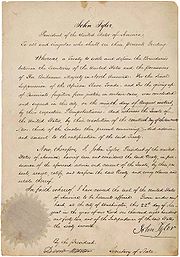
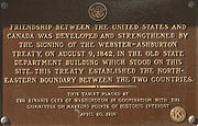
The treaty was signed by United States Secretary of State
United States Secretary of State
The United States Secretary of State is the head of the United States Department of State, concerned with foreign affairs. The Secretary is a member of the Cabinet and the highest-ranking cabinet secretary both in line of succession and order of precedence...
Daniel Webster
Daniel Webster
Daniel Webster was a leading American statesman and senator from Massachusetts during the period leading up to the Civil War. He first rose to regional prominence through his defense of New England shipping interests...
and British diplomat Alexander Baring, 1st Baron Ashburton
Alexander Baring, 1st Baron Ashburton
Alexander Baring, 1st Baron Ashburton PC was a British politician and financier.-Background:Baring was the second son of Sir Francis Baring, 1st Baronet, and of Harriet, daughter of William Herring...
. A plaque commemorating the treaty was placed at the site of the old State Department building in Washington, D.C. where the signing occurred.
In the East
The treaty was responsible for a geographic oddity. Since "Fort Blunder", an unnamed US fort in what is now part of northeastern New York, had been inadvertently constructed on Canadian soil, the northern border of New York between the St. Lawrence River and the New York-Vermont line was adjusted 3/4 of a mile northward, beyond the 45th parallel, thus placing the half-finished and abandoned fort on US soil. Following the signing of the treaty, construction was resumed on the site. The new effort replaced the aborted 1812-era construction with a massive third-system masonry fortification known as Fort MontgomeryFort Montgomery (Lake Champlain)
Fort Montgomery on Lake Champlain refers to the second of two American forts built at the northernmost point on the lake: a first, unnamed fort built on the same site in 1816 and Fort Montgomery built in 1844....
.
This treaty marked the end of unofficial fighting (known informally as the Aroostook War
Aroostook War
The Aroostook War was an undeclared nonviolent confrontation in 1838/1839 between the United States and Great Britain over the international boundary between British North America and Maine. The compromise resolution win a mutually accepted border between the state of Maine and the provinces of...
) along the Maine
Maine
Maine is a state in the New England region of the northeastern United States, bordered by the Atlantic Ocean to the east and south, New Hampshire to the west, and the Canadian provinces of Quebec to the northwest and New Brunswick to the northeast. Maine is both the northernmost and easternmost...
border with the Canadian provinces of Quebec
Quebec
Quebec or is a province in east-central Canada. It is the only Canadian province with a predominantly French-speaking population and the only one whose sole official language is French at the provincial level....
and New Brunswick
New Brunswick
New Brunswick is one of Canada's three Maritime provinces and is the only province in the federation that is constitutionally bilingual . The provincial capital is Fredericton and Saint John is the most populous city. Greater Moncton is the largest Census Metropolitan Area...
and resolved issues that had led to the Indian Stream dispute
Republic of Indian Stream
The Republic of Indian Stream was a small, unrecognized, constitutional republic in North America, along the section of the US–Canada border that divides the Canadian province of Quebec from the US state of New Hampshire. It existed from July 9, 1832 to 1835...
as well as the Caroline Affair
Caroline affair
The Caroline affair was a series of events beginning in 1837 that strained relations between the United States and Britain....
. The border was fixed with the disputed territory divided between the two nations. The British acquired the Halifax-Quebec road route they desired. Also, as a result of this treaty, portions of the US-Canada border were adjusted so as to give the US negligibly more land to the north. The Creole case
Creole case
The Creole case was the result of a slave rebellion in 1841 on board the Creole, a ship involved in the United States coastwise slave trade.-The revolt:...
was passed over by both nations.
The Webster–Ashburton Treaty failed to clarify ownership of Machias Seal Island
Machias Seal Island
Machias Seal Island is an island located in the Gulf of Maine, approximately southeast from Cutler, Maine, and approximately southwest of Southwest Head, New Brunswick on Grand Manan Island. Machias Seal Island is located at and measures approximately in area. It is a neighbour to North Rock....
and nearby North Rock
North Rock
North Rock is an offshore rock with geographical coordinates of , located to the east of the North American continent near the boundary between the Gulf of Maine and the Bay of Fundy....
, which remain in dispute today.
In the West
The border between Lake Superior and the Lake of the Woods needed clarification because the faulty Mitchell MapMitchell Map
The Mitchell Map is a map made by John Mitchell , which was reprinted several times during the second half of the 18th century. The Mitchell Map was used as a primary map source during the Treaty of Paris for defining the boundaries of the newly independent United States...
used in the negotiations for the Treaty of Paris (1783)
Treaty of Paris (1783)
The Treaty of Paris, signed on September 3, 1783, ended the American Revolutionary War between Great Britain on the one hand and the United States of America and its allies on the other. The other combatant nations, France, Spain and the Dutch Republic had separate agreements; for details of...
was inadequate to define the border according to the terms of that treaty. The ambiguity in the map and treaty resulted in Minnesota's Arrowhead region
Arrowhead Region
The Arrowhead Region is located in the northeastern part of the U.S. state of Minnesota, so called because of its pointed shape. The predominantly rural region encompasses of land area and comprises Carlton, Cook, Lake and St. Louis Counties. Its population at the 2000 census was 248,425 residents...
being disputed, and previous negotiations had not resolved the question. The treaty speaks of the border passing through "Long Lake", the location of which was unstated, but the map showed the lake flowing out into Lake Superior near Isle Royale
Isle Royale
Isle Royale is an island of the Great Lakes, located in the northwest of Lake Superior, and part of the state of Michigan. The island and the 450 surrounding smaller islands and waters make up Isle Royale National Park....
, which is consistent with the Pigeon River route.
The British however had previously taken the position that the border should leave Lake Superior at Fond du Lac (the "head of the lake") in modern Duluth, Minnesota
Duluth, Minnesota
Duluth is a port city in the U.S. state of Minnesota and is the county seat of Saint Louis County. The fourth largest city in Minnesota, Duluth had a total population of 86,265 in the 2010 census. Duluth is also the second largest city that is located on Lake Superior after Thunder Bay, Ontario,...
, proceed up the St. Louis and Embarrass Rivers
Embarrass River (Minnesota)
-See also:*List of rivers of Minnesota-References:**USGS Hydrologic Unit Map - State of Minnesota...
, across the height of land, and down Pike River and Lake Vermilion
Lake Vermilion
Lake Vermilion is a freshwater lake in northeastern Minnesota, United States. The Ojibwe originally called the lake Onamuni, which means "Lake of the Sunset Glow". French fur traders translated this to the Latin word Vermilion, which is a red pigment...
to the Rainy River
Rainy River (Minnesota-Ontario)
The Rainy River is a river, approximately long, which forms part of the U.S.-Canada border separating northern Minnesota and Northwestern Ontario....
.
To counter this western route, the U.S. advocated for an eastern route, used by early French explorer Jacques de Noyon
Jacques de Noyon
Jacques de Noyon was a French Canadian explorer and coureur des bois. He is the first known European to visit the Boundary Waters region west of Lake Superior.Jacques de Noyon was born on February 12, 1668, in Trois-Rivières, New France...
in 1688 and the later location of the fur-traders route after 1802. This way headed north from the lake at the site of Fort William, Ontario
Fort William, Ontario
Fort William was a city in Northern Ontario, located on the Kaministiquia River, at its entrance to Lake Superior. It amalgamated with Port Arthur and the townships of Neebing and McIntyre to form the city of Thunder Bay in January 1970. Ever since then it has been the largest city in Northwestern...
up the Kaministiquia
Kaministiquia River
The Kaministiquia River is a river which empties into western Lake Superior at the city of Thunder Bay, Ontario. Kaministiquia is an Ojibwe word meaning " with islands" due to two large islands at the mouth of the river...
and Dog Rivers to Cold Water Lake, crossed the divide by Prairie Portage to Height of Land Lake, then went west by way of the Savanne, Pickerel, and Maligne Rivers to Lake La Croix where it joined the present border. The Mitchell map had shown both of those routes, and also showed the "Long Lake" route between them. Long Lake was thought to be the Pigeon River
Pigeon River (Minnesota-Ontario)
The Pigeon River forms part of the US-Canada border between the State of Minnesota and the Province of Ontario west of Lake Superior. In pre-industrial times the river was a waterway of great importance for transportation and trade.-Geography:...
(despite the absence of a lake at its mouth), and the traditional traders' route there left the Lake at Grand Portage and went overland to the Pigeon, up that river and a tributary across the Height of Land Portage
Height of Land Portage
Height of Land Portage is a portage along the historic Boundary Waters route between Canada and the United States. Located at the border of the Canadian province of Ontario and the U.S...
, and thence down tributaries of the Rainy River to Lac La Croix, Rainy Lake and River, and Lake of the Woods. This is the route which was designated as the border in the treaty.
Another clarification made in this treaty resulted in cementing the anomaly of the Northwest Angle
Northwest Angle
The Northwest Angle, known simply as the Angle by locals, and coextensive with Angle Township, is a part of northern Lake of the Woods County, Minnesota, and is the only place in the United States outside Alaska that is north of the 49th parallel...
. Again, due to errors on the Mitchell Map, Treaty of Paris reads "... through the Lake of the Woods to the most northwesternmost point thereof, and from thence on a due west course to the river Mississippi ..." With the border clarification established by the Anglo-American Convention of 1818 defining the boundary about Lake of the Woods to the Rocky Mountains, this treaty reaffirmed the border and further detailed the border by modifying the border definition to instead read as "... at the Chaudiere Falls, from which the Commissioners traced the line to the most northwestern point of the Lake of the Woods, thence, along the said line to the said most northwestern point, being in latitude 49°23′55″ north, and in longitude 95°14′38″ west from the Observatory at Greenwich; thence, according to existing treaties, due south to its intersection with the 49th parallel of north latitude, and along that parallel to the Rocky Mountains ..."
The Webster–Ashburton Treaty failed to deal with the Oregon question
Oregon boundary dispute
The Oregon boundary dispute, or the Oregon Question, arose as a result of competing British and American claims to the Pacific Northwest of North America in the first half of the 19th century. Both the United Kingdom and the United States had territorial and commercial aspirations in the region...
, although the issue was discussed in negotiations.
Results
Ultimately, the only "losers" were the original (BrayonBrayon
Brayons are a francophone people inhabiting the area in and around Edmundston, New Brunswick, Canada. In French, they are called or feminine , and both terms are also used as adjectives, as in Brayon culture, or .) Given their location in New Brunswick, a Canadian Maritime province, they are...
and Native
Indigenous peoples of the Americas
The indigenous peoples of the Americas are the pre-Columbian inhabitants of North and South America, their descendants and other ethnic groups who are identified with those peoples. Indigenous peoples are known in Canada as Aboriginal peoples, and in the United States as Native Americans...
) inhabitants of the region, who saw not only their homeland but also their people split between the American state of Maine
Maine
Maine is a state in the New England region of the northeastern United States, bordered by the Atlantic Ocean to the east and south, New Hampshire to the west, and the Canadian provinces of Quebec to the northwest and New Brunswick to the northeast. Maine is both the northernmost and easternmost...
and the British colony of New Brunswick
New Brunswick
New Brunswick is one of Canada's three Maritime provinces and is the only province in the federation that is constitutionally bilingual . The provincial capital is Fredericton and Saint John is the most populous city. Greater Moncton is the largest Census Metropolitan Area...
.
Shortly after ratification of this treaty, the Ojibwa
Ojibwa
The Ojibwe or Chippewa are among the largest groups of Native Americans–First Nations north of Mexico. They are divided between Canada and the United States. In Canada, they are the third-largest population among First Nations, surpassed only by Cree and Inuit...
nations about the south shore of Lake Superior ceded land to the United States in the Treaty of La Pointe
Treaty of La Pointe
The Treaty of La Pointe may refer to either of two treaties made and signed in La Pointe, Wisconsin between the United States and the Ojibwe Native American peoples...
. However, the news of the ratification of this treaty did not reach either negotiation party for the second treaty, causing the Grand Portage Band to be omitted for the treaty council. In addition, the Grand Portage Band was misinformed on the details of the Treaty of Paris, thinking the border passed through the center of Lake Superior to the Saint Louis River, placing both Isle Royale and themselves in British territory. This was wrong since Treaty of Paris specifically mentions Isle Royale to be in the territories of the United States. Consequently, the Isle Royale Agreement was signed between the United States and the Grand Portage Band in 1844 as an adhesion to the Treaty of La Pointe, with other Ojibwa tribes reaffirming the treaty.
Ten months of negotiations for the treaty were held largely at the Ashburton House
Ashburton House
Ashburton House, also known as St. John's Church Parish House or British Legation, is a house on Lafayette Square in Washington, D.C..It was the site of 10 months of U.S.-British negotiations leading to the Webster-Ashburton Treaty of 1842...
, home of the British legation on Lafayette Square in Washington, D.C. The house has been designated a U.S. National Historic Landmark
National Historic Landmark
A National Historic Landmark is a building, site, structure, object, or district, that is officially recognized by the United States government for its historical significance...
.
In order to make the controversial treaty more popular in the United States, Webster released a map of the Maine-Canada border which he claimed had been drawn by Benjamin Franklin
Benjamin Franklin
Dr. Benjamin Franklin was one of the Founding Fathers of the United States. A noted polymath, Franklin was a leading author, printer, political theorist, politician, postmaster, scientist, musician, inventor, satirist, civic activist, statesman, and diplomat...
. It showed British ownership of the area America claimed and largely received. Many historians believe that this map was forged.
See also
- List of treaties
- Timeline of United States diplomatic historyTimeline of United States diplomatic historyThe diplomatic history of the United States oscillated among three positions: isolation from diplomatic entanglements of other nations ; alliances with European and other military partners; and unilateralism, or operating on its own sovereign policy decisions...
- Estcourt Station, MaineEstcourt Station, MaineEstcourt Station is a village in Big Twenty Township, Aroostook County, Maine, United States. It is the northernmost point in Maine and New England....
- Oregon boundary disputeOregon boundary disputeThe Oregon boundary dispute, or the Oregon Question, arose as a result of competing British and American claims to the Pacific Northwest of North America in the first half of the 19th century. Both the United Kingdom and the United States had territorial and commercial aspirations in the region...
Further reading
- Carroll, Francis M. "Drawing the Line" Beaver 2003 83(4): 19-25
- Carroll, Francis M. "The Passionate Canadians: The Historical Debate about the Eastern Canadian-American Boundary," New England Quarterly, Vol. 70, No. 1 (Mar., 1997), pp. 83-101 in JSTOR
- Carroll, Francis M. A Good and Wise Measure: The Search for the Canadian-American Boundary, 1783-1842. (University of Toronto Press, 2001) 462 pp.; the standardscholarly history
- Corey, Albert B. The Crisis of 1830-1842 in Canadian-American Relations (1941) online edition
- Jones. Howard. "Anglophobia and the Aroostook War," New England Quarterly, Vol. 48, No. 4 (Dec., 1975), pp. 519-539 in JSTOR
- Jones. Howard. To the Webster–Ashburton Treaty: A Study in Anglo-American Relations, 1783-1843 (1977). 251 pp. online edition
- Jones, Wilbur Devereux. "The Influence of Slavery on the Webster-Ashburton Negotiations," Journal of Southern History, Vol. 22, No. 1 (Feb., 1956), pp. 48-58 in JSTOR
- LeDuc, Thomas. "The Webster-Ashburton Treaty and the Minnesota Iron Ranges," Journal of American History, Vol. 51, No. 3 (Dec., 1964), pp. 476-481 in JSTOR, shows the value of the iron range was not known when the treaty was drawn
- Merk, Frederick. "The Oregon Question in the Webster-Ashburton Negotiations," Mississippi Valley Historical Review, Vol. 43, No. 3 (Dec., 1956), pp. 379-404 in JSTOR
- Remini, Robert. Daniel Webster (1997) pp 535–64
External links
- Text of the Webster-Ashburton Treaty (The Avalon Project at Yale Law School)
- Webster-Ashburton Treaty (U.S. Department of State)
- Franklin Map Possibly Forged