
Michigan Territory
Encyclopedia
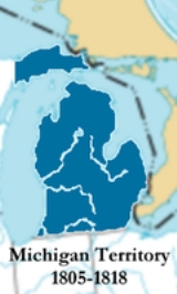
The Territory of Michigan was an organized incorporated territory of the United States that existed from June 30, 1805, until January 26, 1837, when the final extent of the territory was admitted to the Union
as the State of Michigan. Detroit was the territorial capital.
tribes and isolated settlements of trappers and traders accounted for most of the inhabitants of what would become Michigan.
and then British
control. The first Jesuit mission, in 1668 at Sault Saint Marie
, led to the establishment of further outposts at St. Ignace
(where a mission began work in 1671) and Detroit, first occupied in 1701 by the garrison of the former Fort de Buade
under the leadership of Cadillac
. Soon after their arrival, his troops erected Fort Pontchartrain du Detroit and a church
dedicated to Saint Anne
, the mother of the Virgin Mary. As part of New France
, the upper Great Lakes
had first been governed from Michilimackinac
, then Detroit; this was essentially a military regime that reported to the governor-general at Quebec
. Its role was to supply the needs of the fur traders and discourage any settlements not directly supportive of that effort. After the surrender of Montreal in 1760, British troops under Robert Rogers
occupied Detroit and its dependent posts. In 1763, Pontiac's Rebellion saw the fall of Fort Michilimackinac
to the northern tribes, and a lengthy siege of Fort Detroit
. The siege was lifted in 1764, and rule under a British lieutenant-governor at Detroit followed soon thereafter.
Due to the Quebec Act
of 1774, Michigan and what is now Western Ontario were governed during the Revolution and in the following years as part of the Province of Quebec
and its District of Hesse
, which was organized in 1784. The province was split into Lower Canada
(today's Province of Quebec) and Upper Canada
(Ontario
) in 1791, and the districts of Upper Canada were renamed the next year, with the Detroit area designated as the Western District
.
Following the American Revolutionary War
, several states had competing claims on land in the region. In 1779, Virginia
established Illinois County
with boundaries that encompassed all of the land east of the Mississippi River
, north of the Ohio River
and west of the Appalachian Mountains
. (However, the county government for all practical purposes never exercised actual control beyond an area limited to a few old French settlements along the major rivers. The overwhelming majority of the northwestern lands were controlled by the native tribes.) New York
, Connecticut
, and Massachusetts
also claimed portions of what was to become Michigan, but were even less able to enforce their pretensions, given Britain's control of the Great Lakes and the hostility of the tribes.
Although the 1783 Treaty of Paris
gave the fledgling United States a claim to what is now Michigan, British policy was to hold on to Detroit and its dependencies at all costs. In 1784, Baron von Steuben would be sent to Canada by the Congress of the Confederation
in a diplomatic capacity to address the question of Detroit and the Great Lakes, but lieutenant governor Frederick Haldimand
refused to provide a passport, and negotiations collapsed before they had begun.
Virginia surrendered its claim to lands north and west of the Ohio River
, effective March 1, 1784. Coincidentally (or not) this was the same day that the findings of a Congressional committee
on the western lands, chaired by Thomas Jefferson
since the previous October, were reported. Jefferson's recommendations became the basis for the Ordinance of 1784, which established that new states equal in all respects to the founding thirteen would be erected in the territory, that they would forever be a part of the United States, and that their governments would be republican in form. The Land Ordinance of 1785
would go further by establishing a procedure for land sales in the new territory, but the Ohio River remained an effective boundary between the United States and the Northwest tribes for a few more years.
The other states with claims in the Northwest eventually followed Virginia's example, and in 1787, the Continental Congress
enacted the Northwest Ordinance
, which created the Northwest Territory
. The first settlement under the Northwest Ordinance was at Marietta
, in 1788.
The region that became Michigan was initially unorganized territory, and remained under British control until 1796; that did not stop Governor Arthur St. Clair
from establishing a structure of government for the area, if only on paper. Knox County
was established on June 20, 1790 with boundaries that included the western half of the Lower Peninsula of Michigan
and roughly the middle third of the Upper Peninsula of Michigan
. In 1792, the boundaries of Hamilton County
were expanded to include the eastern portions of Michigan not included in Knox County.
American claims to Michigan were frustrated by Britain's refusal to evacuate the forts at Detroit, Mackinac
and elsewhere. Britain's tacit support for the Northwest tribes during the Northwest Indian War
was dependent on Detroit remaining out of American hands. But the position of the British and their allies in the Northwest deteriorated after the signing of Jay's Treaty and the Battle of Fallen Timbers
in 1794, and after negotiations, the British evacuated Detroit on July 11, 1796. The United States had finally established a presence in Michigan.
was established August 15, 1796, from Knox and Hamilton counties, and included most of the area that later became the Michigan Territory, as well as portions of what are now Ohio, Indiana, Illinois, and Wisconsin.
In 1800, the western half of the Lower Peninsula and most of the Upper Peninsula was attached to Indiana Territory
when it was established as a separate government from the Northwest Territory. Wayne County was thereby reduced to the remainder of the two peninsulas, and continued under the government of the Northwest Territory. St. Clair County
, another Indiana Territory county, was also expanded at this time, to include the western portion of the Upper Peninsula and a small sliver of the Lower Peninsula along the shore of Lake Michigan
.
When Ohio was admitted as a state in early 1803, the eastern half of Michigan was attached to the Indiana Territory. One of the first acts taken that year by the Indiana government under William Henry Harrison
was to reorganize Wayne County under Indiana law, adding territory from Knox and St. Clair counties. Michigan's first county now encompassed all of the Lower Peninsula, much of the Upper Peninsula, and those portions of today's Illinois, Indiana, and Wisconsin that drained into Lake Michigan.
In many respects, the change from the government of the Northwest Territory to that of the Indiana Territory had little effect on Wayne County's limited operations. By Governor Harrison's proclamation of January 11, 1803, the courts of Wayne County—common pleas, orphans, and quarter sessions—kept their organization under the new territorial government, with almost identical composition.
But the logistics of government went from difficult to almost impossible, with the mail between Detroit and the capital at Vincennes being routed at one point through Warren in northeastern Ohio. The deciding factor may have come when an election was called by Governor Harrison for September 11, 1804, to decide whether Indiana Territory (which by this time was responsible for not only the settlements in Michigan, Wisconsin and Illinois, but the newly-acquired District of Louisiana
as well) should progress to the second stage of territorial government. But word failed to reach Detroit until after the date had passed, and the settlers of Michigan petitioned Congress in December 1804, asking that Wayne County be set off as an independent territory.
 Michigan Territory was established by an act of the United States Congress
on January 11, 1805, effective June 30 of that year. The act defined the territory as "all that part of the Indiana Territory, which lies North of a line drawn east from the southerly bend or extreme of lake Michigan, until it shall intersect lake Erie, and East of a line drawn from the said southerly bend through the middle of said lake to its northern extremity, and thence due north to the northern boundary of the United States." A historical marker at a roadside park, approximately three miles east of Naubinway at 46°05′50"N 85°23′51"W, commemorates the northernmost point of Lake Michigan, which is located approximately one mile west of the park.
The first territorial governor, William Hull
abolished Wayne County and established new districts of his own making, which proved to be short-lived. Lewis Cass
became governor in 1813 and promptly undid Hull's work and re-established a third incarnation of Wayne County that included all lands within Michigan Territory that had been ceded by Native Americans through the 1807 Treaty of Detroit
.
During the War of 1812
, following General Isaac Brock's
capture of Detroit on August 16, 1812, the Michigan Territory was at least nominally a part of the Province of Upper Canad
a. On August 24, Colonel Henry Proctor proclaimed the continuation of civil government under existing laws with Proctor acting as Governor and Chief Justice Augustus B. Woodward
acting as Secretary. On February 4, 1813, Proctor suspended civil government and imposed martial law
.
When Indiana
(1816) and Illinois
(1818) joined the Union, remnants of their territories were joined to Michigan Territory. An area equal to 30 townships
was also transferred from Michigan Territory to Indiana to allow that state access to Lake Michigan. Soon afterward, the federal government rapidly began signing treaties with local Indian tribes and acquiring their lands.
In 1824, the Michigan Territory graduated to the second grade of territorial status, and the government's power was transferred from the Governor and a handful of judges to the people. The people elected 18 to the Legislative Council, of which nine were approved by the President
, and it first sat in council on June 7, 1824. This Council was expanded from nine members to 13 in 1825, with the 13 being chosen by the President from a field of 26.
The Erie Canal
opened in 1825, allowing settlers from New England
and New York
to reach Michigan by water through Albany and Buffalo.
In 1834, all of the lands acquired in the Louisiana Purchase
that were as yet unallocated and lay east of the Missouri River
(generally, the Dakotas
, Iowa and the western half of Minnesota
) were attached to the Michigan Territory, an area that was officially characterized as "north of Missouri
and east of the Missouri
and White Earth River
s." At this point, Michigan Territory included what is now the states of Michigan, Wisconsin
, Iowa
, Minnesota
and a large portion of the Dakotas.
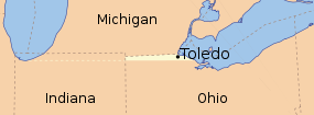 Meanwhile, in 1835, the Toledo War
was fought with Ohio because Michigan Territory wanted to retain the disputed "Toledo Strip." The Toledo area of Ohio was finally surrendered in exchange for the western section of the Upper Peninsula of Michigan
.
Slavery was forbidden in the territory under the Northwest Ordinance
, but British and French residents were permitted to retain possession of slaves already owned at the time the territory became organized. Census records show that the slave population in the territory numbered 24 in 1810 and 32 in 1830. It is believed that those counted as slaves were, in many cases, enslaved Native Americans
rather than enslaved African Americans.
On July 3, 1836, in preparation for Michigan statehood, the Wisconsin Territory
was organized from Michigan Territory, consisting of the present states of Wisconsin, Minnesota, Iowa and the eastern portion of the Dakotas. Michigan became a state on January 26, 1837, and included the Upper Peninsula as far west as the Montreal River
as part of the resolution to the conflict over the Toledo Strip, which had blocked Michigan statehood for several years. Detroit remained the capital until March 17, 1847 when Lansing
was chosen as a replacement. The population of Michigan at the time of statehood is estimated to have been about 200,000, which was well above the Northwest Ordinance
's minimum requirement of 60,000.
, Ojibwa
and the Wyandot. Treaties ceding the land were signed between 1795 (the Treaty of Greenville
) and 1842 (the Treaty of La Pointe
). Other notable treaties were Governor Hull's treaty of 1808, the Treaty of Saginaw
in 1819, the two Treaties of Chicago
(1821, 1833), the Carey Mission
in 1828 and the Treaty of Washington
in 1836 and a later treaty of January 4, 1837.
, originally part of the vast Northwest Territory, was eventually whittled down into its current size by the separation of several tracts: Monroe
in 1817, Michilimackinac County (later called Mackinac
) and Macomb
counties in 1818, St. Clair
and St. Joseph
counties in 1820 and Washtenaw County
in 1822. The first township organization was Detroit, in Wayne County, in 1802.
Also organized in 1818 were two counties that survive in present-day Wisconsin
. Crawford was set up to govern the settlements on the upper Mississippi River
from its seat at Prairie du Chien, Wisconsin, while Brown performed a similar function for the settlements around Green Bay
. These would become part of the Wisconsin Territory
in 1836.
Oakland County, Michigan
was created in 1819, and over time was subdivided into all or parts of Genesee
, Lapeer
, Sanilac
, Shiawassee
and Saginaw
counties. Saginaw County would be split further into eight separate counties, three of which (Isabella
, Arenac
and Midland
) were established during the territorial period.
Lenawee County
was created in 1822 from what had been Indian lands, and Hillsdale County
was separated from it in 1829. Other parts of Lenawee were turned into Cass
and Berrien
. Branch
also sprung fully formed from Michigan Territory in 1829.
Chippewa County
was created from Michilimackinac County in 1826.
Kalamazoo County, Michigan
, established 1829 from St. Joseph County, was the dominant tract in Western Michigan
and was divided and subdivided into many other counties: Allegan
, Barry
, Calhoun
, Eaton
, Ionia
, Montcalm
, Kent
, Ottawa
and Clinton
(some created during the territorial period, others split off later).
Jackson
and Ingham
were created in 1829 from Washtenaw; Isabella
was created from parts of Saginaw and Midland
counties in 1831. Gratiot County
was also established in 1831, with land from Saginaw and Clinton counties.
Seven of the 12 counties created in 1829 were named for members of President Andrew Jackson's Cabinet, and one was named for Jackson himself.
Iowa County
, with its seat at Mineral Point
, was established in 1829 and transferred to the Wisconsin Territory in 1836.
Michigan Territory briefly governed lands west of the Mississippi, after the statehood of Missouri
left the area north of the new state as unorganized territory; this comprised what is now Iowa
and that part of Minnesota west of the river. Such was the case until 1834, when that area was placed under the government of Michigan Territory. Dubuque
and Des Moines
counties were created in 1834, and transferred to the Wisconsin Territory in 1836 upon its organization.
Milwaukee County was established in 1834 and was transferred to Wisconsin Territory two years later.
had 43,365 residents. Under the Northwest Ordinance, a territory could apply for statehood once it had surpassed 60,000 inhabitants.
.
United States
The United States of America is a federal constitutional republic comprising fifty states and a federal district...
as the State of Michigan. Detroit was the territorial capital.
History and government
The earliest European explorers of Michigan saw it mostly as a place to control the fur trade. Small military forces, Jesuit missions to Native AmericanNative Americans in the United States
Native Americans in the United States are the indigenous peoples in North America within the boundaries of the present-day continental United States, parts of Alaska, and the island state of Hawaii. They are composed of numerous, distinct tribes, states, and ethnic groups, many of which survive as...
tribes and isolated settlements of trappers and traders accounted for most of the inhabitants of what would become Michigan.
Early government in Michigan
After the arrival of Europeans, the area that became the Michigan Territory was first under FrenchFrench colonization of the Americas
The French colonization of the Americas began in the 16th century, and continued in the following centuries as France established a colonial empire in the Western Hemisphere. France founded colonies in much of eastern North America, on a number of Caribbean islands, and in South America...
and then British
British colonization of the Americas
British colonization of the Americas began in 1607 in Jamestown, Virginia and reached its peak when colonies had been established throughout the Americas...
control. The first Jesuit mission, in 1668 at Sault Saint Marie
Sault Ste. Marie, Michigan
Sault Ste. Marie is a city in and the county seat of Chippewa County in the U.S. state of Michigan. It is in the north-eastern end of Michigan's Upper Peninsula, on the Canadian border, separated from its twin city of Sault Ste. Marie, Ontario, by the St. Marys River...
, led to the establishment of further outposts at St. Ignace
St. Ignace, Michigan
Saint Ignace, usually written as St. Ignace, is a city in the U.S. state of Michigan. As of the 2000 census, the city population was 2,678. It is the county seat of Mackinac County. From the Lower Peninsula, St. Ignace is the gateway to the Upper Peninsula.St...
(where a mission began work in 1671) and Detroit, first occupied in 1701 by the garrison of the former Fort de Buade
Fort de Buade
Fort de Buade was a French fort at the present site of St. Ignace in the U.S. state of Michigan. It was garrisoned between 1683 and 1701.-The mission:...
under the leadership of Cadillac
Antoine Laumet de La Mothe, sieur de Cadillac
Antoine Laumet de La Mothe, sieur de Cadillac was a French explorer and adventurer in New France, now an area of North America stretching from Eastern Canada in the north to Louisiana in the south. Rising from a modest beginning in Acadia in 1683 as an explorer, trapper, and a trader of alcohol...
. Soon after their arrival, his troops erected Fort Pontchartrain du Detroit and a church
Ste. Anne de Detroit Catholic Church
Ste. Anne de Détroit, founded July 26, 1701, is the second oldest continuously operating Roman Catholic parish in the United States. The current church, built in 1886, is located at 1000 Ste. Anne St. in Detroit, Michigan near the Richard-Hubbard neighborhood area, the Ambassador Bridge, and the...
dedicated to Saint Anne
Saint Anne
Saint Hanna of David's house and line, was the mother of the Virgin Mary and grandmother of Jesus Christ according to Christian and Islamic tradition. English Anne is derived from Greek rendering of her Hebrew name Hannah...
, the mother of the Virgin Mary. As part of New France
New France
New France was the area colonized by France in North America during a period beginning with the exploration of the Saint Lawrence River by Jacques Cartier in 1534 and ending with the cession of New France to Spain and Great Britain in 1763...
, the upper Great Lakes
Great Lakes
The Great Lakes are a collection of freshwater lakes located in northeastern North America, on the Canada – United States border. Consisting of Lakes Superior, Michigan, Huron, Erie, and Ontario, they form the largest group of freshwater lakes on Earth by total surface, coming in second by volume...
had first been governed from Michilimackinac
Michilimackinac
Michilimackinac is a name for the region around the Straits of Mackinac between Lake Huron and Lake Michigan. Early settlers of North America applied the term to the entire region along Lakes Huron, Michigan, and Superior. Today it is mostly within the boundaries of Michigan, in the United States...
, then Detroit; this was essentially a military regime that reported to the governor-general at Quebec
Quebec
Quebec or is a province in east-central Canada. It is the only Canadian province with a predominantly French-speaking population and the only one whose sole official language is French at the provincial level....
. Its role was to supply the needs of the fur traders and discourage any settlements not directly supportive of that effort. After the surrender of Montreal in 1760, British troops under Robert Rogers
Robert Rogers (soldier)
Robert Rogers was an American colonial frontiersman. Rogers served in the British army during both the French and Indian War and the American Revolution...
occupied Detroit and its dependent posts. In 1763, Pontiac's Rebellion saw the fall of Fort Michilimackinac
Fort Michilimackinac
Fort Michilimackinac was an 18th century French, and later British, fort and trading post in the Great Lakes of North America. Built around 1715, it was located along the southern shore of the strategic Straits of Mackinac connecting Lake Huron and Lake Michigan, at the northern tip of the lower...
to the northern tribes, and a lengthy siege of Fort Detroit
Siege of Fort Detroit
The Siege of Fort Detroit was an ultimately unsuccessful attempt by North American Indians to capture Fort Detroit during Pontiac's Rebellion. The siege was led primarily by Pontiac, an Ottawa war leader.-Background:...
. The siege was lifted in 1764, and rule under a British lieutenant-governor at Detroit followed soon thereafter.
Due to the Quebec Act
Quebec Act
The Quebec Act of 1774 was an Act of the Parliament of Great Britain setting procedures of governance in the Province of Quebec...
of 1774, Michigan and what is now Western Ontario were governed during the Revolution and in the following years as part of the Province of Quebec
Province of Quebec (1763-1791)
The Province of Quebec was a colony in North America created by Great Britain after the Seven Years' War. Great Britain acquired Canada by the Treaty of Paris when King Louis XV of France and his advisors chose to keep the territory of Guadeloupe for its valuable sugar crops instead of New France...
and its District of Hesse
Western District, Upper Canada
Western District was one of four districts of the Province of Quebec created in 1788 in the western reaches of the Montreal District and partitioned in 1791 to create the new colony of Upper Canada. Known as Hesse District until 1792, it was abolished in 1849...
, which was organized in 1784. The province was split into Lower Canada
Lower Canada
The Province of Lower Canada was a British colony on the lower Saint Lawrence River and the shores of the Gulf of Saint Lawrence...
(today's Province of Quebec) and Upper Canada
Upper Canada
The Province of Upper Canada was a political division in British Canada established in 1791 by the British Empire to govern the central third of the lands in British North America and to accommodate Loyalist refugees from the United States of America after the American Revolution...
(Ontario
Ontario
Ontario is a province of Canada, located in east-central Canada. It is Canada's most populous province and second largest in total area. It is home to the nation's most populous city, Toronto, and the nation's capital, Ottawa....
) in 1791, and the districts of Upper Canada were renamed the next year, with the Detroit area designated as the Western District
Western District, Upper Canada
Western District was one of four districts of the Province of Quebec created in 1788 in the western reaches of the Montreal District and partitioned in 1791 to create the new colony of Upper Canada. Known as Hesse District until 1792, it was abolished in 1849...
.
Following the American Revolutionary War
American Revolutionary War
The American Revolutionary War , the American War of Independence, or simply the Revolutionary War, began as a war between the Kingdom of Great Britain and thirteen British colonies in North America, and ended in a global war between several European great powers.The war was the result of the...
, several states had competing claims on land in the region. In 1779, Virginia
Virginia
The Commonwealth of Virginia , is a U.S. state on the Atlantic Coast of the Southern United States. Virginia is nicknamed the "Old Dominion" and sometimes the "Mother of Presidents" after the eight U.S. presidents born there...
established Illinois County
Illinois County, Virginia
Illinois County, Virginia, was a geographic region captured from the British during the American Revolutionary War on July 4, 1778 by George Rogers Clark of the Virginia Army, and formally recognized by the Commonwealth of Virginia later that year, having an official governmental existence,...
with boundaries that encompassed all of the land east of the Mississippi River
Mississippi River
The Mississippi River is the largest river system in North America. Flowing entirely in the United States, this river rises in western Minnesota and meanders slowly southwards for to the Mississippi River Delta at the Gulf of Mexico. With its many tributaries, the Mississippi's watershed drains...
, north of the Ohio River
Ohio River
The Ohio River is the largest tributary, by volume, of the Mississippi River. At the confluence, the Ohio is even bigger than the Mississippi and, thus, is hydrologically the main stream of the whole river system, including the Allegheny River further upstream...
and west of the Appalachian Mountains
Appalachian Mountains
The Appalachian Mountains #Whether the stressed vowel is or ,#Whether the "ch" is pronounced as a fricative or an affricate , and#Whether the final vowel is the monophthong or the diphthong .), often called the Appalachians, are a system of mountains in eastern North America. The Appalachians...
. (However, the county government for all practical purposes never exercised actual control beyond an area limited to a few old French settlements along the major rivers. The overwhelming majority of the northwestern lands were controlled by the native tribes.) New York
New York
New York is a state in the Northeastern region of the United States. It is the nation's third most populous state. New York is bordered by New Jersey and Pennsylvania to the south, and by Connecticut, Massachusetts and Vermont to the east...
, Connecticut
Connecticut
Connecticut is a state in the New England region of the northeastern United States. It is bordered by Rhode Island to the east, Massachusetts to the north, and the state of New York to the west and the south .Connecticut is named for the Connecticut River, the major U.S. river that approximately...
, and Massachusetts
Massachusetts
The Commonwealth of Massachusetts is a state in the New England region of the northeastern United States of America. It is bordered by Rhode Island and Connecticut to the south, New York to the west, and Vermont and New Hampshire to the north; at its east lies the Atlantic Ocean. As of the 2010...
also claimed portions of what was to become Michigan, but were even less able to enforce their pretensions, given Britain's control of the Great Lakes and the hostility of the tribes.
Although the 1783 Treaty of Paris
Treaty of Paris (1783)
The Treaty of Paris, signed on September 3, 1783, ended the American Revolutionary War between Great Britain on the one hand and the United States of America and its allies on the other. The other combatant nations, France, Spain and the Dutch Republic had separate agreements; for details of...
gave the fledgling United States a claim to what is now Michigan, British policy was to hold on to Detroit and its dependencies at all costs. In 1784, Baron von Steuben would be sent to Canada by the Congress of the Confederation
Congress of the Confederation
The Congress of the Confederation or the United States in Congress Assembled was the governing body of the United States of America that existed from March 1, 1781, to March 4, 1789. It comprised delegates appointed by the legislatures of the states. It was the immediate successor to the Second...
in a diplomatic capacity to address the question of Detroit and the Great Lakes, but lieutenant governor Frederick Haldimand
Frederick Haldimand
Sir Frederick Haldimand, KB was a military officer best known for his service in the British Army in North America during the Seven Years' War and the American Revolutionary War...
refused to provide a passport, and negotiations collapsed before they had begun.
Virginia surrendered its claim to lands north and west of the Ohio River
Ohio River
The Ohio River is the largest tributary, by volume, of the Mississippi River. At the confluence, the Ohio is even bigger than the Mississippi and, thus, is hydrologically the main stream of the whole river system, including the Allegheny River further upstream...
, effective March 1, 1784. Coincidentally (or not) this was the same day that the findings of a Congressional committee
Congress of the Confederation
The Congress of the Confederation or the United States in Congress Assembled was the governing body of the United States of America that existed from March 1, 1781, to March 4, 1789. It comprised delegates appointed by the legislatures of the states. It was the immediate successor to the Second...
on the western lands, chaired by Thomas Jefferson
Thomas Jefferson
Thomas Jefferson was the principal author of the United States Declaration of Independence and the Statute of Virginia for Religious Freedom , the third President of the United States and founder of the University of Virginia...
since the previous October, were reported. Jefferson's recommendations became the basis for the Ordinance of 1784, which established that new states equal in all respects to the founding thirteen would be erected in the territory, that they would forever be a part of the United States, and that their governments would be republican in form. The Land Ordinance of 1785
Land Ordinance of 1785
The Land Ordinance of 1785 was adopted by the United States Congress on May 20, 1785. Under the Articles of Confederation, Congress did not have the power to raise revenue by direct taxation of the inhabitants of the United States...
would go further by establishing a procedure for land sales in the new territory, but the Ohio River remained an effective boundary between the United States and the Northwest tribes for a few more years.
The other states with claims in the Northwest eventually followed Virginia's example, and in 1787, the Continental Congress
Continental Congress
The Continental Congress was a convention of delegates called together from the Thirteen Colonies that became the governing body of the United States during the American Revolution....
enacted the Northwest Ordinance
Northwest Ordinance
The Northwest Ordinance was an act of the Congress of the Confederation of the United States, passed July 13, 1787...
, which created the Northwest Territory
Northwest Territory
The Territory Northwest of the River Ohio, more commonly known as the Northwest Territory, was an organized incorporated territory of the United States that existed from July 13, 1787, until March 1, 1803, when the southeastern portion of the territory was admitted to the Union as the state of Ohio...
. The first settlement under the Northwest Ordinance was at Marietta
Marietta, Ohio
Marietta is a city in and the county seat of Washington County, Ohio, United States. During 1788, pioneers to the Ohio Country established Marietta as the first permanent American settlement of the new United States in the Northwest Territory. Marietta is located in southeastern Ohio at the mouth...
, in 1788.
The region that became Michigan was initially unorganized territory, and remained under British control until 1796; that did not stop Governor Arthur St. Clair
Arthur St. Clair
Arthur St. Clair was an American soldier and politician. Born in Scotland, he served in the British Army during the French and Indian War before settling in Pennsylvania, where he held local office...
from establishing a structure of government for the area, if only on paper. Knox County
Knox County, Indiana
As of the census of 2000, there were 39,256 people, 15,552 households, and 10,139 families residing in the county. The population density was 76 people per square mile . There were 17,305 housing units at an average density of 34 per square mile...
was established on June 20, 1790 with boundaries that included the western half of the Lower Peninsula of Michigan
Lower Peninsula of Michigan
The Lower Peninsula of Michigan is the southern of the two major landmasses of the U.S. state of Michigan. It is surrounded by water on all sides except its southern border, which it shares with Ohio and Indiana. Geographically, the Lower Peninsula has a recognizable shape that many people...
and roughly the middle third of the Upper Peninsula of Michigan
Upper Peninsula of Michigan
The Upper Peninsula of Michigan is the northern of the two major land masses that make up the U.S. state of Michigan. It is commonly referred to as the Upper Peninsula, the U.P., or Upper Michigan. It is also known as the land "above the Bridge" linking the two peninsulas. The peninsula is bounded...
. In 1792, the boundaries of Hamilton County
Hamilton County, Ohio
As of 2000, there were 845,303 people, 346,790 households, and 212,582 families residing in the county. The population density was 2,075 people per square mile . There were 373,393 housing units at an average density of 917 per square mile...
were expanded to include the eastern portions of Michigan not included in Knox County.
American claims to Michigan were frustrated by Britain's refusal to evacuate the forts at Detroit, Mackinac
Fort Mackinac
Fort Mackinac is a former American military outpost garrisoned from the late 18th century to the late 19th century near Michilimackinac, Michigan, on Mackinac Island...
and elsewhere. Britain's tacit support for the Northwest tribes during the Northwest Indian War
Northwest Indian War
The Northwest Indian War , also known as Little Turtle's War and by various other names, was a war fought between the United States and a confederation of numerous American Indian tribes for control of the Northwest Territory...
was dependent on Detroit remaining out of American hands. But the position of the British and their allies in the Northwest deteriorated after the signing of Jay's Treaty and the Battle of Fallen Timbers
Battle of Fallen Timbers
The Battle of Fallen Timbers was the final battle of the Northwest Indian War, a struggle between American Indian tribes affiliated with the Western Confederacy and the United States for control of the Northwest Territory...
in 1794, and after negotiations, the British evacuated Detroit on July 11, 1796. The United States had finally established a presence in Michigan.
Beginnings of American rule
By proclamation of acting governor and territorial secretary Winthrop Sargent, the "first" Wayne CountyWayne County, Michigan
-History:Wayne County was one of the first counties formed when the Northwest Territory was organized. It was named for the American general "Mad Anthony" Wayne. It originally encompassed the entire area of the Lower Peninsula of Michigan, as well as small sections that are now part of northern...
was established August 15, 1796, from Knox and Hamilton counties, and included most of the area that later became the Michigan Territory, as well as portions of what are now Ohio, Indiana, Illinois, and Wisconsin.
In 1800, the western half of the Lower Peninsula and most of the Upper Peninsula was attached to Indiana Territory
Indiana Territory
The Territory of Indiana was an organized incorporated territory of the United States that existed from July 4, 1800, until November 7, 1816, when the southern portion of the territory was admitted to the Union as the state of Indiana....
when it was established as a separate government from the Northwest Territory. Wayne County was thereby reduced to the remainder of the two peninsulas, and continued under the government of the Northwest Territory. St. Clair County
St. Clair County, Illinois
St. Clair County is a county located in the U.S. state of Illinois. In 1970, the U.S. Census Bureau placed the mean center of U.S. population in St. Clair County. According to the 2010 census, it has a population of 270,056, which is an increase of 5.5% from 256,082 in 2000. Its county seat is...
, another Indiana Territory county, was also expanded at this time, to include the western portion of the Upper Peninsula and a small sliver of the Lower Peninsula along the shore of Lake Michigan
Lake Michigan
Lake Michigan is one of the five Great Lakes of North America and the only one located entirely within the United States. It is the second largest of the Great Lakes by volume and the third largest by surface area, after Lake Superior and Lake Huron...
.
When Ohio was admitted as a state in early 1803, the eastern half of Michigan was attached to the Indiana Territory. One of the first acts taken that year by the Indiana government under William Henry Harrison
William Henry Harrison
William Henry Harrison was the ninth President of the United States , an American military officer and politician, and the first president to die in office. He was 68 years, 23 days old when elected, the oldest president elected until Ronald Reagan in 1980, and last President to be born before the...
was to reorganize Wayne County under Indiana law, adding territory from Knox and St. Clair counties. Michigan's first county now encompassed all of the Lower Peninsula, much of the Upper Peninsula, and those portions of today's Illinois, Indiana, and Wisconsin that drained into Lake Michigan.
In many respects, the change from the government of the Northwest Territory to that of the Indiana Territory had little effect on Wayne County's limited operations. By Governor Harrison's proclamation of January 11, 1803, the courts of Wayne County—common pleas, orphans, and quarter sessions—kept their organization under the new territorial government, with almost identical composition.
But the logistics of government went from difficult to almost impossible, with the mail between Detroit and the capital at Vincennes being routed at one point through Warren in northeastern Ohio. The deciding factor may have come when an election was called by Governor Harrison for September 11, 1804, to decide whether Indiana Territory (which by this time was responsible for not only the settlements in Michigan, Wisconsin and Illinois, but the newly-acquired District of Louisiana
District of Louisiana
The District of Louisiana, or Louisiana District, was an official, temporary, United States government designation for the portion of the Louisiana Purchase that had not been organized into the Orleans Territory. It officially existed from March 10, 1804 until July 4, 1805, when it was incorporated...
as well) should progress to the second stage of territorial government. But word failed to reach Detroit until after the date had passed, and the settlers of Michigan petitioned Congress in December 1804, asking that Wayne County be set off as an independent territory.
Organization
United States Congress
The United States Congress is the bicameral legislature of the federal government of the United States, consisting of the Senate and the House of Representatives. The Congress meets in the United States Capitol in Washington, D.C....
on January 11, 1805, effective June 30 of that year. The act defined the territory as "all that part of the Indiana Territory, which lies North of a line drawn east from the southerly bend or extreme of lake Michigan, until it shall intersect lake Erie, and East of a line drawn from the said southerly bend through the middle of said lake to its northern extremity, and thence due north to the northern boundary of the United States." A historical marker at a roadside park, approximately three miles east of Naubinway at 46°05′50"N 85°23′51"W, commemorates the northernmost point of Lake Michigan, which is located approximately one mile west of the park.
The first territorial governor, William Hull
William Hull
William Hull was an American soldier and politician. He fought in the American Revolution, was Governor of Michigan Territory, and was a general in the War of 1812, for which he is best remembered for surrendering Fort Detroit to the British.- Early life and Revolutionary War :He was born in...
abolished Wayne County and established new districts of his own making, which proved to be short-lived. Lewis Cass
Lewis Cass
Lewis Cass was an American military officer and politician. During his long political career, Cass served as a governor of the Michigan Territory, an American ambassador, a U.S. Senator representing Michigan, and co-founder as well as first Masonic Grand Master of the Grand Lodge of Michigan...
became governor in 1813 and promptly undid Hull's work and re-established a third incarnation of Wayne County that included all lands within Michigan Territory that had been ceded by Native Americans through the 1807 Treaty of Detroit
Treaty of Detroit
The Treaty of Detroit was a treaty between the United States and the Ottawa, Chippewa, Wyandot and Potawatomi Native American nations. The treaty was signed at Detroit, Michigan on November 17, 1807, with William Hull, governor of the Michigan Territory and superintendent of Indian affairs the sole...
.
During the War of 1812
War of 1812
The War of 1812 was a military conflict fought between the forces of the United States of America and those of the British Empire. The Americans declared war in 1812 for several reasons, including trade restrictions because of Britain's ongoing war with France, impressment of American merchant...
, following General Isaac Brock's
Isaac Brock
Major-General Sir Isaac Brock KB was a British Army officer and administrator. Brock was assigned to Canada in 1802. Despite facing desertions and near-mutinies, he commanded his regiment in Upper Canada successfully for many years...
capture of Detroit on August 16, 1812, the Michigan Territory was at least nominally a part of the Province of Upper Canad
Upper Canada
The Province of Upper Canada was a political division in British Canada established in 1791 by the British Empire to govern the central third of the lands in British North America and to accommodate Loyalist refugees from the United States of America after the American Revolution...
a. On August 24, Colonel Henry Proctor proclaimed the continuation of civil government under existing laws with Proctor acting as Governor and Chief Justice Augustus B. Woodward
Augustus B. Woodward
Augustus Brevoort Woodward was the first Chief Justice of the Michigan Territory. In that position, he played a prominent role in the planning and reconstruction of Detroit following a devastating fire.Woodward never married. His biographer, Arthur M...
acting as Secretary. On February 4, 1813, Proctor suspended civil government and imposed martial law
Martial law
Martial law is the imposition of military rule by military authorities over designated regions on an emergency basis— only temporary—when the civilian government or civilian authorities fail to function effectively , when there are extensive riots and protests, or when the disobedience of the law...
.
When Indiana
Indiana
Indiana is a US state, admitted to the United States as the 19th on December 11, 1816. It is located in the Midwestern United States and Great Lakes Region. With 6,483,802 residents, the state is ranked 15th in population and 16th in population density. Indiana is ranked 38th in land area and is...
(1816) and Illinois
Illinois
Illinois is the fifth-most populous state of the United States of America, and is often noted for being a microcosm of the entire country. With Chicago in the northeast, small industrial cities and great agricultural productivity in central and northern Illinois, and natural resources like coal,...
(1818) joined the Union, remnants of their territories were joined to Michigan Territory. An area equal to 30 townships
Civil township
A civil township is a widely used unit of local government in the United States, subordinate to, and geographic divisions of, a county. Specific responsibilities and the degree of autonomy vary based on each state. Civil townships are distinct from survey townships, but in states that have both,...
was also transferred from Michigan Territory to Indiana to allow that state access to Lake Michigan. Soon afterward, the federal government rapidly began signing treaties with local Indian tribes and acquiring their lands.
In 1824, the Michigan Territory graduated to the second grade of territorial status, and the government's power was transferred from the Governor and a handful of judges to the people. The people elected 18 to the Legislative Council, of which nine were approved by the President
President of the United States
The President of the United States of America is the head of state and head of government of the United States. The president leads the executive branch of the federal government and is the commander-in-chief of the United States Armed Forces....
, and it first sat in council on June 7, 1824. This Council was expanded from nine members to 13 in 1825, with the 13 being chosen by the President from a field of 26.
The Erie Canal
Erie Canal
The Erie Canal is a waterway in New York that runs about from Albany, New York, on the Hudson River to Buffalo, New York, at Lake Erie, completing a navigable water route from the Atlantic Ocean to the Great Lakes. The canal contains 36 locks and encompasses a total elevation differential of...
opened in 1825, allowing settlers from New England
New England
New England is a region in the northeastern corner of the United States consisting of the six states of Maine, New Hampshire, Vermont, Massachusetts, Rhode Island, and Connecticut...
and New York
New York
New York is a state in the Northeastern region of the United States. It is the nation's third most populous state. New York is bordered by New Jersey and Pennsylvania to the south, and by Connecticut, Massachusetts and Vermont to the east...
to reach Michigan by water through Albany and Buffalo.
In 1834, all of the lands acquired in the Louisiana Purchase
Louisiana Purchase
The Louisiana Purchase was the acquisition by the United States of America of of France's claim to the territory of Louisiana in 1803. The U.S...
that were as yet unallocated and lay east of the Missouri River
Missouri River
The Missouri River flows through the central United States, and is a tributary of the Mississippi River. It is the longest river in North America and drains the third largest area, though only the thirteenth largest by discharge. The Missouri's watershed encompasses most of the American Great...
(generally, the Dakotas
The Dakotas
The Dakotas is a collective term that refers to the U.S. states of North Dakota and South Dakota together. The term has been used historically to describe the Dakota Territory, and is continued to be used to describe the collective heritage, culture, geography, fauna, sociology, the economy, and...
, Iowa and the western half of Minnesota
Minnesota
Minnesota is a U.S. state located in the Midwestern United States. The twelfth largest state of the U.S., it is the twenty-first most populous, with 5.3 million residents. Minnesota was carved out of the eastern half of the Minnesota Territory and admitted to the Union as the thirty-second state...
) were attached to the Michigan Territory, an area that was officially characterized as "north of Missouri
Missouri
Missouri is a US state located in the Midwestern United States, bordered by Iowa, Illinois, Kentucky, Tennessee, Arkansas, Oklahoma, Kansas and Nebraska. With a 2010 population of 5,988,927, Missouri is the 18th most populous state in the nation and the fifth most populous in the Midwest. It...
and east of the Missouri
Missouri River
The Missouri River flows through the central United States, and is a tributary of the Mississippi River. It is the longest river in North America and drains the third largest area, though only the thirteenth largest by discharge. The Missouri's watershed encompasses most of the American Great...
and White Earth River
White Earth River (North Dakota)
The White Earth River is a tributary of the Missouri River, approximately 50 mi long, in northwestern North Dakota in the United States. It rises in the plains of southeastern Divide County, approximately 10 mi east of Wildrose. It flows east and south, through Mountrail County and...
s." At this point, Michigan Territory included what is now the states of Michigan, Wisconsin
Wisconsin
Wisconsin is a U.S. state located in the north-central United States and is part of the Midwest. It is bordered by Minnesota to the west, Iowa to the southwest, Illinois to the south, Lake Michigan to the east, Michigan to the northeast, and Lake Superior to the north. Wisconsin's capital is...
, Iowa
Iowa
Iowa is a state located in the Midwestern United States, an area often referred to as the "American Heartland". It derives its name from the Ioway people, one of the many American Indian tribes that occupied the state at the time of European exploration. Iowa was a part of the French colony of New...
, Minnesota
Minnesota
Minnesota is a U.S. state located in the Midwestern United States. The twelfth largest state of the U.S., it is the twenty-first most populous, with 5.3 million residents. Minnesota was carved out of the eastern half of the Minnesota Territory and admitted to the Union as the thirty-second state...
and a large portion of the Dakotas.
Toledo War
The Toledo War , also known as the Michigan-Ohio War, was the almost entirely bloodless boundary dispute between the U.S. state of Ohio and the adjoining territory of Michigan....
was fought with Ohio because Michigan Territory wanted to retain the disputed "Toledo Strip." The Toledo area of Ohio was finally surrendered in exchange for the western section of the Upper Peninsula of Michigan
Upper Peninsula of Michigan
The Upper Peninsula of Michigan is the northern of the two major land masses that make up the U.S. state of Michigan. It is commonly referred to as the Upper Peninsula, the U.P., or Upper Michigan. It is also known as the land "above the Bridge" linking the two peninsulas. The peninsula is bounded...
.
Slavery was forbidden in the territory under the Northwest Ordinance
Northwest Ordinance
The Northwest Ordinance was an act of the Congress of the Confederation of the United States, passed July 13, 1787...
, but British and French residents were permitted to retain possession of slaves already owned at the time the territory became organized. Census records show that the slave population in the territory numbered 24 in 1810 and 32 in 1830. It is believed that those counted as slaves were, in many cases, enslaved Native Americans
Native Americans in the United States
Native Americans in the United States are the indigenous peoples in North America within the boundaries of the present-day continental United States, parts of Alaska, and the island state of Hawaii. They are composed of numerous, distinct tribes, states, and ethnic groups, many of which survive as...
rather than enslaved African Americans.
On July 3, 1836, in preparation for Michigan statehood, the Wisconsin Territory
Wisconsin Territory
The Territory of Wisconsin was an organized incorporated territory of the United States that existed from July 3, 1836, until May 29, 1848, when an eastern portion of the territory was admitted to the Union as the State of Wisconsin...
was organized from Michigan Territory, consisting of the present states of Wisconsin, Minnesota, Iowa and the eastern portion of the Dakotas. Michigan became a state on January 26, 1837, and included the Upper Peninsula as far west as the Montreal River
Montreal River (Wisconsin-Michigan)
The Montreal River is a river flowing to Lake Superior in northern Wisconsin and the Upper Peninsula of Michigan in the United States. It is approximately 40 miles long and drains approximately 270 square miles in a forested region. For most of its length, the river's course is used to define a...
as part of the resolution to the conflict over the Toledo Strip, which had blocked Michigan statehood for several years. Detroit remained the capital until March 17, 1847 when Lansing
Lansing, Michigan
Lansing is the capital of the U.S. state of Michigan. It is located mostly in Ingham County, although small portions of the city extend into Eaton County. The 2010 Census places the city's population at 114,297, making it the fifth largest city in Michigan...
was chosen as a replacement. The population of Michigan at the time of statehood is estimated to have been about 200,000, which was well above the Northwest Ordinance
Northwest Ordinance
The Northwest Ordinance was an act of the Congress of the Confederation of the United States, passed July 13, 1787...
's minimum requirement of 60,000.
Territorial acquisition
The area that became Michigan had been British territory, and was ceded to the United States in 1783, although the native peoples of the area had not ceded control to either the British or Americans for most of the territory by 1783. The majority of it was gained by cession, coerced or otherwise. The people who resided in Michigan before American settlement were the Ottawa, the PotawatomiPotawatomi
The Potawatomi are a Native American people of the upper Mississippi River region. They traditionally speak the Potawatomi language, a member of the Algonquian family. In the Potawatomi language, they generally call themselves Bodéwadmi, a name that means "keepers of the fire" and that was applied...
, Ojibwa
Ojibwa
The Ojibwe or Chippewa are among the largest groups of Native Americans–First Nations north of Mexico. They are divided between Canada and the United States. In Canada, they are the third-largest population among First Nations, surpassed only by Cree and Inuit...
and the Wyandot. Treaties ceding the land were signed between 1795 (the Treaty of Greenville
Treaty of Greenville
The Treaty of Greenville was signed at Fort Greenville , on August 3, 1795, between a coalition of Native Americans & Frontiers men, known as the Western Confederacy, and the United States following the Native American loss at the Battle of Fallen Timbers. It put an end to the Northwest Indian War...
) and 1842 (the Treaty of La Pointe
Treaty of La Pointe
The Treaty of La Pointe may refer to either of two treaties made and signed in La Pointe, Wisconsin between the United States and the Ojibwe Native American peoples...
). Other notable treaties were Governor Hull's treaty of 1808, the Treaty of Saginaw
Treaty of Saginaw
The Treaty of Saginaw, also known as the Treaty with the Chippewa, was made between Gen. Lewis Cass and Chief John Okemos, Chief Wasso and other Native American tribes of the Great Lakes region in what is now the United States, on September 24, 1819, proclaimed by the President of the United...
in 1819, the two Treaties of Chicago
Treaty of Chicago
The Treaty of Chicago may refer to either of two treaties made and signed in Chicago, Illinois between the United States and the Ottawa, Ojibwe , and Potawatomi Native American peoples.-1821 Treaty of Chicago:...
(1821, 1833), the Carey Mission
Carey Mission
The Carey Mission was established by Baptist missionary Isaac McCoy among the Potawatomi tribe of American Indians on the St. Joseph River near Niles, Michigan, USA in December, 1822. It was named for William Carey, a noted English Baptist missionary...
in 1828 and the Treaty of Washington
Treaty of Washington (1836)
The Treaty of Washington is a treaty between the United States and representatives of the Ottawa and Chippewa nations of Native Americans. With this treaty, the tribes ceded an area of approximately 13,837,207 acres in the northwest portion of the Lower Peninsula of Michigan and the eastern...
in 1836 and a later treaty of January 4, 1837.
Territorial subdivisions
Wayne County, MichiganWayne County, Michigan
-History:Wayne County was one of the first counties formed when the Northwest Territory was organized. It was named for the American general "Mad Anthony" Wayne. It originally encompassed the entire area of the Lower Peninsula of Michigan, as well as small sections that are now part of northern...
, originally part of the vast Northwest Territory, was eventually whittled down into its current size by the separation of several tracts: Monroe
Monroe County, Michigan
Monroe County is a county in the U.S. state of Michigan. According to the U.S. Census Bureau, the 2010 population is 152,021. The largest city and county seat is Monroe. The U.S. Census Bureau defines all of Monroe County as conterminous with the Monroe Metropolitan Area...
in 1817, Michilimackinac County (later called Mackinac
Mackinac County, Michigan
-Local Airports:*Mackinac County Airport *Mackinac Island Airport -Airline service:The nearest airports with scheduled passenger service are:*Chippewa County International Airport in Sault Ste...
) and Macomb
Macomb County, Michigan
-Demographics:As of the census of 2000, there were 788,149 people, 309,203 households, and 210,876 families residing in the county. The population density was 1,640 people per square mile . There were 320,276 housing units at an average density of 667 per square mile...
counties in 1818, St. Clair
St. Clair County, Michigan
-Interstates:* I-69 enters the county from the west, coming from Lansing and Flint, terminating at the approach to the Blue Water Bridge in Port Huron....
and St. Joseph
St. Joseph County, Michigan
-Demographics:As of the census of 2000, there were 62,422 people, 23,381 households, and 16,600 families residing in the county. The population density was 124 people per square mile . There were 26,503 housing units at an average density of 53 per square mile...
counties in 1820 and Washtenaw County
Washtenaw County, Michigan
Washtenaw County is a county in the U.S. state of Michigan. As of the 2010 census, the population was 344,791. Its county seat is Ann Arbor. The United States Office of Management and Budget defines the county as part of the Detroit–Warren–Flint Combined Statistical Area...
in 1822. The first township organization was Detroit, in Wayne County, in 1802.
Also organized in 1818 were two counties that survive in present-day Wisconsin
Wisconsin
Wisconsin is a U.S. state located in the north-central United States and is part of the Midwest. It is bordered by Minnesota to the west, Iowa to the southwest, Illinois to the south, Lake Michigan to the east, Michigan to the northeast, and Lake Superior to the north. Wisconsin's capital is...
. Crawford was set up to govern the settlements on the upper Mississippi River
Mississippi River
The Mississippi River is the largest river system in North America. Flowing entirely in the United States, this river rises in western Minnesota and meanders slowly southwards for to the Mississippi River Delta at the Gulf of Mexico. With its many tributaries, the Mississippi's watershed drains...
from its seat at Prairie du Chien, Wisconsin, while Brown performed a similar function for the settlements around Green Bay
Green Bay, Wisconsin
Green Bay is a city in and the county seat of Brown County in the U.S. state of Wisconsin, located at the head of Green Bay, a sub-basin of Lake Michigan, at the mouth of the Fox River. It has an elevation of above sea level and is located north of Milwaukee. As of the 2010 United States Census,...
. These would become part of the Wisconsin Territory
Wisconsin Territory
The Territory of Wisconsin was an organized incorporated territory of the United States that existed from July 3, 1836, until May 29, 1848, when an eastern portion of the territory was admitted to the Union as the State of Wisconsin...
in 1836.
Oakland County, Michigan
Oakland County, Michigan
-Demographics:As of the 2010 Census, there were 1,202,362 people, 471,115 households, and 315,175 families residing in the county. The population density as of the 2000 census was 1,369 people per square mile . There were 492,006 housing units at an average density of 564 per square mile...
was created in 1819, and over time was subdivided into all or parts of Genesee
Genesee County, Michigan
-Interstates:* I-69* I-75* I-475-Michigan State Trunklines:* M-13* M-15* M-21* M-54* M-57-Demographics:As of the census of 2000, there were 436,141 people, 169,825 households, and 115,990 families residing in the county. The population density was 682 people per square mile . There were 183,630...
, Lapeer
Lapeer County, Michigan
-Demographics:As of the census of 2000, there were 87,904 people, 30,729 households, and 23,876 families residing in the county. The population density was 134 people per square mile . There were 32,732 housing units at an average density of 50 per square mile...
, Sanilac
Sanilac County, Michigan
-Highways:* M-19* M-25* M-46* M-53* M-81* M-90-History:Sanilac County was probably named for a Wyandot chief named Sanilac. See List of Michigan county name etymologies....
, Shiawassee
Shiawassee County, Michigan
-Transportation:-Demographics:As of the census of 2000, there were 71,687 people, 26,896 households, and 19,849 families residing in the county. The population density was 133 people per square mile . There were 29,087 housing units at an average density of 54 per square mile...
and Saginaw
Saginaw County, Michigan
-Demographics:As of the census of 2000, there were 210,039 people, 80,430 households, and 55,818 families residing in the county. The population density was 260 people per square mile . There were 85,505 housing units at an average density of 106 per square mile...
counties. Saginaw County would be split further into eight separate counties, three of which (Isabella
Isabella County, Michigan
-Demographics:As of the census of 2000, there were 63,351 people, 22,425 households, and 13,006 families residing in the county. The population density was 110 people per square mile . There were 24,528 housing units at an average density of 43 per square mile...
, Arenac
Arenac County, Michigan
-Demographics:As of the 2000 census, there were 17,269 people, 6,710 households, and 4,717 families residing in the county. The population density was 47 people per square mile . There were 9,563 housing units at an average density of 26 per square mile...
and Midland
Midland County, Michigan
-Demographics:As of the census of 2000, there were 82,874 people, 31,769 households, and 22,683 families residing in the county. The population density was 159 people per square mile . There were 33,796 housing units at an average density of 65 per square mile...
) were established during the territorial period.
Lenawee County
Lenawee County, Michigan
-Demographics:As of the census of 2000, there were 98,890 people, 35,930 households, and 26,049 families residing in the county. The population density was 132 people per square mile . There were 39,769 housing units at an average density of 53 per square mile...
was created in 1822 from what had been Indian lands, and Hillsdale County
Hillsdale County, Michigan
-Demographics:As of the census of 2000, there were 46,527 people, 17,335 households, and 12,550 families residing in the county. The population density was 78 people per square mile . There were 20,189 housing units at an average density of 34 per square mile...
was separated from it in 1829. Other parts of Lenawee were turned into Cass
Cass County, Michigan
Cass County is a county in the U.S. state of Michigan. As of the 2000 census, the population was 51,104. It is part of the South Bend–Mishawaka, IN-MI, Metropolitan Statistical Area which has a total population of 316,663 and is sometimes considered part of Greater Michiana...
and Berrien
Berrien County, Michigan
Berrien County is a county located in the extreme southwest of the U.S. state of Michigan. It is included in the Niles-Benton Harbor, Michigan Metropolitan Statistical Area. As of the 2010 census, the population was 156,813. The county seat is St. Joseph....
. Branch
Branch County, Michigan
-Demographics:As of the 2000 census, there were 45,787 people, 16,349 households, and 11,575 families residing in the county. The population density was 90 people per square mile . There were 19,822 housing units at an average density of 39 per square mile...
also sprung fully formed from Michigan Territory in 1829.
Chippewa County
Chippewa County, Michigan
-National protected areas:* Harbor Island National Wildlife Refuge* Hiawatha National Forest * Whitefish Point Unit of the Seney National Wildlife Refuge-Demographics:...
was created from Michilimackinac County in 1826.
Kalamazoo County, Michigan
Kalamazoo County, Michigan
-Air Service:*The Kalamazoo & Battle Creek Metro Area is served by Kalamazoo/Battle Creek International Airport.-Interstates:* I-94* I-94 Business Loop-US highways:* US-131* BUS US 131-Michigan State Trunklines:* M-43* M-89* M-96...
, established 1829 from St. Joseph County, was the dominant tract in Western Michigan
Western Michigan
West Michigan and Western Michigan are terms for an arbitrarily selected region in the U.S. state of Michigan in its Lower Peninsula. There is no official definition for what constitutes "West Michigan." The area of West Michigan may also include parts Southern Michigan.-Definition:In general,...
and was divided and subdivided into many other counties: Allegan
Allegan County, Michigan
-Interstates:* I-196* I-196 Business Loop serves the city of Holland.-US highways:* US-31* US-131-Michigan State Trunklines:* M-40* M-89* M-179* M-222-Allegan County Intercounty Highways:* A-2* A-37* A-42* A-45-Demographics:...
, Barry
Barry County, Michigan
-Highways:* M-37* M-43* M-50* M-66* M-78* M-79* M-89* M-179-Demographics:As of the 2000 census, there were 56,755 people, 21,035 households, and 15,986 families residing in the county. The population density was 102 people per square mile . There were 23,876 housing units at an average density of...
, Calhoun
Calhoun County, Michigan
-Interstates:* I-69* I-94* I-194* I-94 Business Loop serves the city of Albion.* I-94 Business Loop serves the city of Battle Creek.* I-94 Business Loop serves the city of Marshall.-Michigan State Trunklines:* M-37* M-60* M-66* M-78* M-89* M-96* M-99...
, Eaton
Eaton County, Michigan
Eaton County is a county in the U.S. state of Michigan. As of the 2010 census, the population was 107,759. The county seat is Charlotte. Eaton County was named for John Eaton, who was Secretary of War under U.S. President Andrew Jackson, making it one of Michigan's Cabinet counties...
, Ionia
Ionia County, Michigan
-Demographics:As of the census of 2000, there were 61,518 people, 20,606 households, and 15,145 families residing in the county. The population density was 107 people per square mile . There were 22,006 housing units at an average density of 38 per square mile...
, Montcalm
Montcalm County, Michigan
-Michigan State Highways:* M-46* M-57* M-66* M-82* M-91-Demographics:As of the census of 2000, there were 61,266 people, 22,079 households, and 16,183 families residing in the county. The population density was 86 people per square mile . There were 25,900 housing units at an average density...
, Kent
Kent County, Michigan
-Air Service:*Commercial air service to Grand Rapids is provided by Gerald R. Ford International Airport . Previously named Kent County International Airport, it holds Grand Rapids' mark in modern history with the United States' first regularly scheduled airline service, beginning July 31, 1926,...
, Ottawa
Ottawa County, Michigan
-Demographics:As of the census of 2000, there were 238,314 people, 81,662 households, and 61,328 families residing in the county. The population density was 421 people per square mile . There were 86,856 housing units at an average density of 154 per square mile...
and Clinton
Clinton County, Michigan
-Demographics:As of the census of 2000, there were 64,753 people, 23,653 households, and 17,976 families residing in the county. The population density was 113 people per square mile . There were 24,630 housing units at an average density of 43 per square mile...
(some created during the territorial period, others split off later).
Jackson
Jackson County, Michigan
As of the census of 2000, there were 158,422 people, 58,168 households, and 40,833 families residing in the county. The population density was 224 people per square mile . There were 62,906 housing units at an average density of 89/sq mi...
and Ingham
Ingham County, Michigan
-Demographics:As of the census of 2000, there were 279,320 people, 108,593 households, and 63,744 families residing in the county. The population density was 500 people per square mile . There were 115,056 housing units at an average density of 206 per square mile...
were created in 1829 from Washtenaw; Isabella
Isabella County, Michigan
-Demographics:As of the census of 2000, there were 63,351 people, 22,425 households, and 13,006 families residing in the county. The population density was 110 people per square mile . There were 24,528 housing units at an average density of 43 per square mile...
was created from parts of Saginaw and Midland
Midland County, Michigan
-Demographics:As of the census of 2000, there were 82,874 people, 31,769 households, and 22,683 families residing in the county. The population density was 159 people per square mile . There were 33,796 housing units at an average density of 65 per square mile...
counties in 1831. Gratiot County
Gratiot County, Michigan
-US Highways:* US-127 routes north to I-75 and south to Lansing.* BUS US-127 is a loop route through downtown Alma.* BUS US-127 is a loop route through downtown Ithaca.* BUS US-127 is a loop route through downtown St. Louis....
was also established in 1831, with land from Saginaw and Clinton counties.
Seven of the 12 counties created in 1829 were named for members of President Andrew Jackson's Cabinet, and one was named for Jackson himself.
Iowa County
Iowa County, Wisconsin
Iowa County is a county located in the U.S. state of Wisconsin. As of 2000, the population was 22,780. Its county seat and largest city is Dodgeville.Iowa County is part of the Madison Metropolitan Statistical Area.-Geography:According to the U.S...
, with its seat at Mineral Point
Mineral Point, Wisconsin
Mineral Point is a city in Iowa County, Wisconsin, United States. The population was 2,617 at the 2000 census. In 2008 the city's population had taken a decline and is currently only 2,462, but still the second most populous community in Iowa County...
, was established in 1829 and transferred to the Wisconsin Territory in 1836.
Michigan Territory briefly governed lands west of the Mississippi, after the statehood of Missouri
Missouri
Missouri is a US state located in the Midwestern United States, bordered by Iowa, Illinois, Kentucky, Tennessee, Arkansas, Oklahoma, Kansas and Nebraska. With a 2010 population of 5,988,927, Missouri is the 18th most populous state in the nation and the fifth most populous in the Midwest. It...
left the area north of the new state as unorganized territory; this comprised what is now Iowa
Iowa
Iowa is a state located in the Midwestern United States, an area often referred to as the "American Heartland". It derives its name from the Ioway people, one of the many American Indian tribes that occupied the state at the time of European exploration. Iowa was a part of the French colony of New...
and that part of Minnesota west of the river. Such was the case until 1834, when that area was placed under the government of Michigan Territory. Dubuque
Dubuque County, Iowa
Dubuque County is a county located in the U.S. state of Iowa. The population was 93,653 in the 2010 census, an increase from 89,143 in the 2000 census. The county seat is the city of Dubuque. Dubuque County is coterminous with the Dubuque, Iowa Metropolitan Statistical Area, and is the seventh...
and Des Moines
Des Moines County, Iowa
-2010 census:The 2010 census recorded a population of 40,325 in the county, with a population density of . There were 18,535 housing units, of which 17,003 were occupied.-2000 census:...
counties were created in 1834, and transferred to the Wisconsin Territory in 1836 upon its organization.
Milwaukee County was established in 1834 and was transferred to Wisconsin Territory two years later.
Territorial population
These census numbers do not include most Native Americans, defined in the U.S. Constitution as "Indians not taxed" (Article I, Sec. 2). In 1800, the whole of the Northwest TerritoryNorthwest Territory
The Territory Northwest of the River Ohio, more commonly known as the Northwest Territory, was an organized incorporated territory of the United States that existed from July 13, 1787, until March 1, 1803, when the southeastern portion of the territory was admitted to the Union as the state of Ohio...
had 43,365 residents. Under the Northwest Ordinance, a territory could apply for statehood once it had surpassed 60,000 inhabitants.
| Year | Population |
|---|---|
| 1810 | 4,762 |
| 1820 | 8,896 |
| 1830 | 31,639 |
| 1834 | 87,273 |
| 1840 | 212,267 |
Governors
| Governor | Dates Served | Notes |
|---|---|---|
| William Hull William Hull William Hull was an American soldier and politician. He fought in the American Revolution, was Governor of Michigan Territory, and was a general in the War of 1812, for which he is best remembered for surrendering Fort Detroit to the British.- Early life and Revolutionary War :He was born in... |
March 1, 1805 to August 16, 1812 | Surrendered Detroit to British forces, August 16, 1812 |
| Henry Proctor | August 24, 1812 to September 28, 1813 | Civil governor under British rule to February 4; martial law thereafter until evacuation of Detroit in September |
| Lewis Cass Lewis Cass Lewis Cass was an American military officer and politician. During his long political career, Cass served as a governor of the Michigan Territory, an American ambassador, a U.S. Senator representing Michigan, and co-founder as well as first Masonic Grand Master of the Grand Lodge of Michigan... |
October 13, 1813 to August 6, 1831 | Appointed military governor by General Harrison William Henry Harrison William Henry Harrison was the ninth President of the United States , an American military officer and politician, and the first president to die in office. He was 68 years, 23 days old when elected, the oldest president elected until Ronald Reagan in 1980, and last President to be born before the... ; civil governor from October 29 |
| George Bryan Porter George Bryan Porter George Bryan Porter , was a U.S. statesman in Pennsylvania and Michigan Territory.He was born in Norristown, Pennsylvania, the brother of David Rittenhouse Porter, Pennsylvania Governor, 1839–1845, and James Madison Porter, Secretary of War, 1843–1844, and the uncle of Horace Porter, U.S.... |
August 6, 1831 to July 6, 1834 | Died in office. |
| Stevens T. Mason Stevens T. Mason Stevens Thomson Mason , also known as Stevens T. Mason, Tom Mason, The Boy Governor, and lesser known nicknames Young Hotspur and The Stripling, was the territorial governor of the Michigan Territory, and later the first Governor of the state of Michigan. Mason guided the Michigan Territory into... |
July 6, 1834 to September 15, 1835 | ex officio, Acting Governor due to position as Secretary |
| John S. Horner John S. Horner John Scott Horner also known as Little Jack Horner was a U.S. politician, Secretary and acting Governor of Michigan Territory, 1835–1836 and Secretary of Wisconsin Territory, 1836-1837.-Early life:... |
September 15, 1835 to July 3, 1836 | ex officio, Acting Governor due to position as Secretary |
Secretaries
| Secretary | Dates Served |
|---|---|
| Stanley Griswold Stanley Griswold Stanley Griswold was a Democratic-Republican politician from Ohio. He served in the U.S. Senate.Born in Torrington, Connecticut, Griswold served in the militia during the Revolutionary War. After graduating from Yale College in 1786, he taught for a time in Norwich, and began studying Theology in... |
March 1, 1805 to March 18, 1808 |
| Reuben Atwater Reuben Atwater Reuben Atwater was the secretary of Michigan Territory and served as acting governor during in 1811-1812.-Biography:... |
March 18, 1808 to October 15, 1814 |
| William Woodbridge William Woodbridge William Woodbridge was a U.S. statesman in the states of Ohio and Michigan and in the Michigan Territory prior to statehood... |
October 15, 1814 to January 15, 1828 |
| James Witherell James Witherell James Witherell was a United States Representative from Vermont. He was born in Mansfield, Massachusetts. After completing preparatory studies, he served in the Continental Army 1775-1783 during the American Revolutionary War. He entered service as a private and rose to the rank of Adjutant in... |
January 15, 1828 to May 20, 1830 |
| John T. Mason | May 20, 1830 to July 12, 1831 |
| Stevens T. Mason Stevens T. Mason Stevens Thomson Mason , also known as Stevens T. Mason, Tom Mason, The Boy Governor, and lesser known nicknames Young Hotspur and The Stripling, was the territorial governor of the Michigan Territory, and later the first Governor of the state of Michigan. Mason guided the Michigan Territory into... |
July 12, 1831 to September 15, 1835 |
| John S. Horner John S. Horner John Scott Horner also known as Little Jack Horner was a U.S. politician, Secretary and acting Governor of Michigan Territory, 1835–1836 and Secretary of Wisconsin Territory, 1836-1837.-Early life:... |
September 15, 1835 to July 3, 1836 |
Supreme Court
From 1805 through 1823, Territorial Supreme Court Justices were appointed by the U.S. President, with consent of the U.S. Senate. Their terms had no fixed limits. In 1823, the U.S. Congress passed an act reorganizing territorial government and setting a four-year term of office for justices.| Supreme Court Justices | Dates Served | Notes |
|---|---|---|
| Augustus B. Woodward Augustus B. Woodward Augustus Brevoort Woodward was the first Chief Justice of the Michigan Territory. In that position, he played a prominent role in the planning and reconstruction of Detroit following a devastating fire.Woodward never married. His biographer, Arthur M... |
March 2, 1805 to February 1, 1824 | Appointed by Thomas Jefferson; resigned following reorganization of court |
| Frederick Bates Frederick Bates Frederick Bates , older brother of Edward Bates and James Woodson Bates, was an American attorney and politician. He was elected in 1824 as the second governor of Missouri and died in office in 1825... |
March 3, 1805 to November, 1808 | Appointed by Thomas Jefferson; resigned after being appointed Secretary of Louisiana Territory Louisiana Territory The Territory of Louisiana or Louisiana Territory was an organized incorporated territory of the United States that existed from July 4, 1805 until June 4, 1812, when it was renamed to Missouri Territory... |
| John Griffin | December 23, 1805 to February 1, 1824 | Appointed by Thomas Jefferson; resigned following reorganization of court |
| James Witherell James Witherell James Witherell was a United States Representative from Vermont. He was born in Mansfield, Massachusetts. After completing preparatory studies, he served in the Continental Army 1775-1783 during the American Revolutionary War. He entered service as a private and rose to the rank of Adjutant in... |
April 23, 1808 to January 15, 1828 | First appointed by Thomas Jefferson; reappointed by James Monroe; resigned after being appointed Secretary of Michigan Territory |
| Solomon Sibley Solomon Sibley Solomon Sibley was a United States politician and jurist in the Michigan Territory.-Early life: 1769–1815:... |
February 2, 1824 to July 17, 1836 | First appointed by James Monroe, reappointed by John Quincy Adams and Andrew Jackson; not reappointed after Michigan statehood |
| John Hunt | February 20, 1824 to June 15, 1827 | Twice appointed by James Monroe; died in office |
| Henry C. Chipman Henry C. Chipman Henry C. Chipman was a judge of the Supreme Territorial Court of Michigan from 1827 until 1832.Chipman was the son of Vermont senator Nathaniel Chipman. He studied at Middlebury College and then moved to South Carolina. He served in the War of 1812. In 1823 he came to Michigan... |
July 18, 1817 to April 25, 1832 | Twice appointed by John Quincy Adams; was not reappointed by Andrew Jackson |
| William Woodbridge William Woodbridge William Woodbridge was a U.S. statesman in the states of Ohio and Michigan and in the Michigan Territory prior to statehood... |
January 15, 1828 to April 25, 1832 | Appointed by John Quincy Adams; was not reappointed by Andrew Jackson |
| Ross Wilkins Ross Wilkins Ross Wilkins was an American politician and lawyer from Pennsylvania, who later served as a territorial and U.S... |
April 26, 1832 to July 17, 1836 | Appointed by Andrew Jackson; appointed U.S. District Court judge for Michigan after statehood |
| George Morrell | April 26, 1832 to July 17, 1843 | First appointed by Andrew Jackson; appointed to the Michigan Supreme Court by Governor Mason |
Congressional delegates
In 1819, Michigan Territory was given the authority to elect a Congressional delegateDelegate (United States Congress)
A delegate to Congress is a non-voting member of the United States House of Representatives who is elected from a U.S. territory and from Washington, D.C. to a two-year term. While unable to vote in the full House, a non-voting delegate may vote in a House committee of which the delegate is a member...
.
| Delegate | Years | Party |
|---|---|---|
| William Woodbridge William Woodbridge William Woodbridge was a U.S. statesman in the states of Ohio and Michigan and in the Michigan Territory prior to statehood... |
1819-20 (16th Congress) | Whig |
| Solomon Sibley Solomon Sibley Solomon Sibley was a United States politician and jurist in the Michigan Territory.-Early life: 1769–1815:... |
1820-23 (16th and 17th Congresses) | |
| Gabriel Richard Gabriel Richard Father Gabriel Richard was a French Roman Catholic priest who became a Delegate from Michigan Territory to the U.S. House of Representatives.... |
1823-25 (18th Congress 18th United States Congress The Eighteenth United States Congress was a meeting of the legislative branch of the United States federal government, consisting of the United States Senate and the United States House of Representatives. It met in Washington, D.C. from March 4, 1823 to March 3, 1825, during the seventh and eighth... ) |
|
| Austin Eli Wing Austin Eli Wing Austin Eli Wing was a delegate to U.S. Congress from Michigan Territory before it became the state of Michigan.... |
1825-29 (19th and 20th Congress 20th United States Congress -House of Representatives:-Leadership:- Senate :* President: John C. Calhoun * President pro tempore: Samuel Smith - House of Representatives :* Speaker: Andrew Stevenson -Members:This list is arranged by chamber, then by state... es) |
|
| John Biddle John Biddle (Michigan) John Biddle was a delegate to the United States Congress from the Michigan Territory.-Early life and military career:... |
1829-31 (21st Congress) | |
| Austin Eli Wing Austin Eli Wing Austin Eli Wing was a delegate to U.S. Congress from Michigan Territory before it became the state of Michigan.... |
1831-33 (22nd Congress) | |
| Lucius Lyon Lucius Lyon Lucius Lyon was a U.S. statesman from the state of Michigan. He was born in Shelburne, Vermont, where he received a common school education and studied engineering and surveying... |
1833-35 (23rd Congress) | Democratic |
| George Wallace Jones | 1835-37 (24th Congress) | Democratic |
Territorial evolution of Michigan
- Territorial evolution of the United StatesTerritorial evolution of the United StatesThis is a list of the evolution of the borders of the United States. This lists each change to the internal and external borders of the country, as well as status and name changes. It also shows the surrounding areas that eventually became part of the United States...
- Territory of FranceFranceThe French Republic , The French Republic , The French Republic , (commonly known as France , is a unitary semi-presidential republic in Western Europe with several overseas territories and islands located on other continents and in the Indian, Pacific, and Atlantic oceans. Metropolitan France...
that encompassed land that would later become part of the Territory of Michigan:- LouisianeLouisiana (New France)Louisiana or French Louisiana was an administrative district of New France. Under French control from 1682–1763 and 1800–03, the area was named in honor of Louis XIV, by French explorer René-Robert Cavelier, Sieur de la Salle...
, 1682–1764 and 1803
- Louisiane
- Territory of SpainSpainSpain , officially the Kingdom of Spain languages]] under the European Charter for Regional or Minority Languages. In each of these, Spain's official name is as follows:;;;;;;), is a country and member state of the European Union located in southwestern Europe on the Iberian Peninsula...
that encompassed land that would later become part of the Territory of Michigan:- LuisianaLouisiana (New Spain)Louisiana was the name of an administrative district of the Viceroyalty of New Spain from 1764 to 1803 that represented territory west of the Mississippi River basin, plus New Orleans...
, 1764–1803
- Luisiana
- U.S. territories that encompassed land that would later become part of the Territory of Michigan:
- Territory Northwest of the River Ohio, 1787–1803
- Territory of Indiana, 1800–1816
- Louisiana PurchaseLouisiana PurchaseThe Louisiana Purchase was the acquisition by the United States of America of of France's claim to the territory of Louisiana in 1803. The U.S...
, 1803–1804 - District of LouisianaDistrict of LouisianaThe District of Louisiana, or Louisiana District, was an official, temporary, United States government designation for the portion of the Louisiana Purchase that had not been organized into the Orleans Territory. It officially existed from March 10, 1804 until July 4, 1805, when it was incorporated...
, 1804–1805 - Territory of Louisiana, 1805–1812
- Territory of Illinois, 1809–1818
- Territory of Missouri, 1812–1821
- U.S. territories that encompassed land that was previously part of the Territory of Michigan:
- Territory of Wisconsin, 1836–1848
- Territory of Iowa, 1838–1846
- Territory of Minnesota, 1849–1858
- Territory of Dakota, 1861–1889
- U.S. states that encompass land that was once part of the Territory of Michigan:
- State of Michigan, 1837
- State of Iowa, 1846
- State of Wisconsin, 1848
- State of Minnesota, 1858
- State of North Dakota, 1889
- State of South Dakota, 1889
- Territory of France
See also
- Historic regions of the United StatesHistoric regions of the United StatesThis is a list of historic regions of the United States.-Colonial era :-The Thirteen Colonies:* Connecticut Colony* Delaware Colony* Province of Georgia* Province of Maryland...
- History of MichiganHistory of MichiganSee also Timeline of Michigan history.Thousands of years before the arrival of the first Europeans, eight indigenous tribes lived in what is today the state of Michigan...
- Michigan Territory MilitiaMichigan Territory MilitiaThe Michigan Territory Militia was the predecessor to the Michigan Army National Guard and existed as an entity concurrent with Michigan Territory's existence in the United States.-Pre-territorial militias:...
- Toledo Strip
- Timeline of the Toledo Strip/WarTimeline of the Toledo Strip/WarThe following is timeline of events surrounding the Toledo War, a mostly bloodless conflict between the U.S. state of Ohio and the Michigan Territory in the early 19th century, over an area of land known as the Toledo Strip, which includes the present-day city of Toledo, Ohio.-1780s:*1787: The...
- Timeline of the Toledo Strip/War
- U.S. stateU.S. stateA U.S. state is any one of the 50 federated states of the United States of America that share sovereignty with the federal government. Because of this shared sovereignty, an American is a citizen both of the federal entity and of his or her state of domicile. Four states use the official title of...
- U.S. territory