

Washington meridian
Encyclopedia
The Washington meridian was one of four prime meridian
s of the United States
which passed through Washington, D.C.
. The four which have been specified are:
Their longitudes may be reported in three ways:
NAD83 longitude of the Capitol is about 1.1 arc seconds less than its NAD27 longitude; astronomic longitude there is about 4 arc seconds less than NAD83.
specified the first meridian
in his 1791 "Plan of the city intended for the permanent seat of the government of the United States . . .". (Shortly after L'Enfant prepared this plan, its subject received the name "City of Washington".) His plan stated that the longitude of the Congress House, now called the Capitol, would be . Longitude of the center of its dome (completed in 1863 during the Civil War
) is now given by the National Geodetic Survey as .

 L'Enfant planned Washington around a right triangle
, having its 90° vertex at an equestrian statue of George Washington
, its eastern vertex at the "Congress house" and its northern vertex at the "President's house", now named the "White House". (This would place L'Enfant's statue 0.36 meter north of the latitude of the Capitol.)
The west side of L'Enfant's triangle forms a natural prime meridian passing through the President's house. The following nine features on and near this "Washington Meridian" are listed from south to north:
.jpg) The third meridian was defined on September 28, 1850 by Congress: "[T]he meridian of the observatory at Washington shall be adopted and used as the American meridian for all astronomical purposes and ... the meridian of Greenwich shall be adopted for all nautical purposes." The observatory decided that this meridian passed through the center of the original (small) dome atop the main building of the Old Naval Observatory, now on the grounds of the United States Navy Bureau of Medicine and Surgery, southwest of the corner of E and 23rd Streets in Foggy Bottom
The third meridian was defined on September 28, 1850 by Congress: "[T]he meridian of the observatory at Washington shall be adopted and used as the American meridian for all astronomical purposes and ... the meridian of Greenwich shall be adopted for all nautical purposes." The observatory decided that this meridian passed through the center of the original (small) dome atop the main building of the Old Naval Observatory, now on the grounds of the United States Navy Bureau of Medicine and Surgery, southwest of the corner of E and 23rd Streets in Foggy Bottom
(north of the Lincoln Memorial
and west of the White House). The observatory adopted for its meridian in the American Ephemeris and Nautical Almanac
for the years 1855 to 1869 (as . In 1897, well after the observatory closed in 1892, the Coast and Geodetic Survey reported that its meridian was west of Greenwich, which was quoted for the next 50 years in the list of observatories in the Almanac (as . When referred to later datums, this meridian has been variously specified as or (both presumably NAD 27). If NAD27, the latter would be which seems to be within a few meters of the actual longitude, at worst. This meridian was repealed by Congress on August 22, 1912 to allow the Greenwich meridian to become the legal prime meridian of the United States.
, California
, Oklahoma
, Texas
) or relative to a river or lake (Arkansas
, Louisiana
, Minnesota
, Missouri
, Oregon
, Washington state).
The following meridians west of Washington are listed east to west, along with the appropriate boundary of the present state. The date of the meridian's definition is in parentheses (all in the 1860s). All states were territories of the same name when their meridians were specified except as noted. States without dates have boundaries dependent on the neighboring state with a date listed immediately above it.
Prime Meridian
The Prime Meridian is the meridian at which the longitude is defined to be 0°.The Prime Meridian and its opposite the 180th meridian , which the International Date Line generally follows, form a great circle that divides the Earth into the Eastern and Western Hemispheres.An international...
s of the United States
United States
The United States of America is a federal constitutional republic comprising fifty states and a federal district...
which passed through Washington, D.C.
History of Washington, D.C.
The history of Washington, D.C. is tied to its role as the capital of the United States. Originally inhabited by an Algonquian-speaking people known as the Nacotchtank, the site of the District of Columbia along the Potomac River was originally selected by President George Washington. The city came...
. The four which have been specified are:
- through the CapitolUnited States CapitolThe United States Capitol is the meeting place of the United States Congress, the legislature of the federal government of the United States. Located in Washington, D.C., it sits atop Capitol Hill at the eastern end of the National Mall...
- through the White HouseWhite HouseThe White House is the official residence and principal workplace of the president of the United States. Located at 1600 Pennsylvania Avenue NW in Washington, D.C., the house was designed by Irish-born James Hoban, and built between 1792 and 1800 of white-painted Aquia sandstone in the Neoclassical...
- through the old Naval ObservatoryFoggy BottomFoggy Bottom is one of the oldest late 18th and 19th-century neighborhoods in Washington, D.C. The area is thought to have received the name because its riverside location made it susceptible to concentrations of fog and industrial smoke, an atmospheric trait that did not prevent the neighborhood...
- through the new Naval ObservatoryUnited States Naval ObservatoryThe United States Naval Observatory is one of the oldest scientific agencies in the United States, with a primary mission to produce Positioning, Navigation, and Timing for the U.S. Navy and the U.S. Department of Defense...
.
Their longitudes may be reported in three ways:
- relative to the local vertical used by astronomic observations
- relative to NAD 27 (North American DatumNorth American DatumThe North American Datum is the official datum used for the primary geodetic network in North America.In the fields of cartography and land-use there are currently two North American Datums in use: the North American Datum of 1927 and the North American Datum of 1983...
1927), an ellipsoid of revolutionFigure of the EarthThe expression figure of the Earth has various meanings in geodesy according to the way it is used and the precision with which the Earth's size and shape is to be defined. The actual topographic surface is most apparent with its variety of land forms and water areas. This is, in fact, the surface...
that is at mean sea level beneath triangulation station Meades Ranch, KansasMeades Ranch, KansasMeades Ranch is a location in Kansas, United States that was designated as the geodetic base point for the North American Datum of 1927 .-Location:...
(not earth-centered); - relative to NAD 83, an earth-centered ellipsoid of revolution with dimensions chosen to best fit the undulating (±100 m) geoidGeoidThe geoid is that equipotential surface which would coincide exactly with the mean ocean surface of the Earth, if the oceans were in equilibrium, at rest , and extended through the continents . According to C.F...
(world-wide mean sea level).
NAD83 longitude of the Capitol is about 1.1 arc seconds less than its NAD27 longitude; astronomic longitude there is about 4 arc seconds less than NAD83.
Capitol meridian
Pierre (Peter) Charles L'EnfantPierre Charles L'Enfant
Pierre Charles L'Enfant was a French-born American architect and civil engineer best known for designing the layout of the streets of Washington, D.C..-Early life:...
specified the first meridian
Meridian (geography)
A meridian is an imaginary line on the Earth's surface from the North Pole to the South Pole that connects all locations along it with a given longitude. The position of a point along the meridian is given by its latitude. Each meridian is perpendicular to all circles of latitude...
in his 1791 "Plan of the city intended for the permanent seat of the government of the United States . . .". (Shortly after L'Enfant prepared this plan, its subject received the name "City of Washington".) His plan stated that the longitude of the Congress House, now called the Capitol, would be . Longitude of the center of its dome (completed in 1863 during the Civil War
American Civil War
The American Civil War was a civil war fought in the United States of America. In response to the election of Abraham Lincoln as President of the United States, 11 southern slave states declared their secession from the United States and formed the Confederate States of America ; the other 25...
) is now given by the National Geodetic Survey as .
White House meridian
Right triangle
A right triangle or right-angled triangle is a triangle in which one angle is a right angle . The relation between the sides and angles of a right triangle is the basis for trigonometry.-Terminology:The side opposite the right angle is called the hypotenuse...
, having its 90° vertex at an equestrian statue of George Washington
George Washington
George Washington was the dominant military and political leader of the new United States of America from 1775 to 1799. He led the American victory over Great Britain in the American Revolutionary War as commander-in-chief of the Continental Army from 1775 to 1783, and presided over the writing of...
, its eastern vertex at the "Congress house" and its northern vertex at the "President's house", now named the "White House". (This would place L'Enfant's statue 0.36 meter north of the latitude of the Capitol.)
The west side of L'Enfant's triangle forms a natural prime meridian passing through the President's house. The following nine features on and near this "Washington Meridian" are listed from south to north:
- The center of the Jefferson MemorialJefferson MemorialThe Thomas Jefferson Memorial is a presidential memorial in Washington, D.C. that is dedicated to Thomas Jefferson, an American Founding Father and the third President of the United States....
, completed on the meridian in 1943. - In 1793 Secretary of StateUnited States Secretary of StateThe United States Secretary of State is the head of the United States Department of State, concerned with foreign affairs. The Secretary is a member of the Cabinet and the highest-ranking cabinet secretary both in line of succession and order of precedence...
Thomas JeffersonThomas JeffersonThomas Jefferson was the principal author of the United States Declaration of Independence and the Statute of Virginia for Religious Freedom , the third President of the United States and founder of the University of Virginia...
surveyed and marked with a wooden post the southwest vertex of L'Enfant's triangle, establishing the second Washington meridian, the one through the President's house. The wooden post was replaced by the Jefferson PierJefferson PierJefferson Pier, Jefferson Stone, or the Jefferson Pier Stone, in Washington, D.C., marks the second prime meridian of the United States even though it was never officially recognized, either by presidential proclamation or by a resolution or act of Congress...
in 1804, while Jefferson was President of the United StatesPresident of the United StatesThe President of the United States of America is the head of state and head of government of the United States. The president leads the executive branch of the federal government and is the commander-in-chief of the United States Armed Forces....
. After removal and replacement several times, it was permanently replaced in 1889 by a 2 foot (0.6096 m), 2-foot-tall, granite pier, now 390 feet (119 m) WNW of the center of the Washington MonumentWashington MonumentThe Washington Monument is an obelisk near the west end of the National Mall in Washington, D.C., built to commemorate the first U.S. president, General George Washington...
. NGS gives its longitude as as of 2002 (likely error less than a centimeter). Azimuth to the Capitol is 89.98 degrees, a discrepancy of just under a meter. - In 1890 the Meridian Stone was set at the center of the Ellipse, intended to be on the same meridian. It is an 18 inches (46 cm) granite post set flush with the ground. NGS gives its longitude as as of 2002 (likely error less than a centimeter).
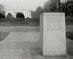
- In 1923, the Zero MilestoneZero MilestoneThe Zero Milestone is a zero mile marker monument in Washington, D.C. intended as the initial milestone from which all road distances in the United States should be reckoned when it was built. At present, only roads in the Washington, D.C...
was set on the north side of the Ellipse, intended to be on the same meridian and to be the zero mileage point for all United States roads (but never was). It is a granite pillar about 18 inches (46 cm) square and about 3.5 feet (1.1 m) tall. NGS gives its longitude as as of 2002 (likely error less than two centimeters). - The center of the White House.
- Clark MillsClark Mills (sculptor)Clark Mills was an American sculptor, best known for three versions of an equestrian statue of Andrew Jackson, located in Washington, D.C., Nashville, Tennessee, and New Orleans, Louisiana.-Life:...
' equestrian statue of President Andrew JacksonAndrew JacksonAndrew Jackson was the seventh President of the United States . Based in frontier Tennessee, Jackson was a politician and army general who defeated the Creek Indians at the Battle of Horseshoe Bend , and the British at the Battle of New Orleans...
in Lafayette Park, erected on the meridian in 1853. - 16th Street Northwest16th Street Northwest (Washington, D.C.)16th Street Northwest is a prominent north-south thoroughfare in the northwest quadrant of Washington, D.C.Part of Pierre L'Enfant's design for the city, 16th Street begins just north of the White House across Lafayette Park at H Street and continues due north in a straight line passing K Street,...
, which extends due north from the White House. The meridian is sometimes identified as the "16th Street Meridian" because of the location of this street. - The following feature on this meridian no longer exists. It was a small freestone obelisk placed in 1804 on top of a hill 1.5 miles (2.4 km) north of the President's House, hence the name Meridian Hill. It was at the northern end of 16th Street, just north of Florida Avenue, before 16th Street was extended northward soon after 1900, covering it up. Now adjoining the east side of 16th Street where the obelisk once stood is Meridian Hill ParkMeridian Hill ParkMeridian Hill Park, is located in the Washington, D.C. neighborhood of Columbia Heights in the United States. The 12 acres of landscaped grounds are maintained by the National Park Service as part of Rock Creek Park, but are not contiguous with the main part of that park...
. - District of Columbia boundary marker stone (approximately 66 feet (20.1 m) east of this meridian) in traffic circle at intersection of 16th Street Northwest, Eastern Avenue NorthwestEastern Avenue (Washington, D.C.)Eastern Avenue is one of three boundary streets between Washington, D.C., and the state of Maryland. It follows a northwest-to-southeast line, beginning at the intersection of 16th Street NW and Colesville Road...
and Colesville Road.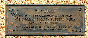
Old Naval Observatory meridian
Foggy Bottom
Foggy Bottom is one of the oldest late 18th and 19th-century neighborhoods in Washington, D.C. The area is thought to have received the name because its riverside location made it susceptible to concentrations of fog and industrial smoke, an atmospheric trait that did not prevent the neighborhood...
(north of the Lincoln Memorial
Lincoln Memorial
The Lincoln Memorial is an American memorial built to honor the 16th President of the United States, Abraham Lincoln. It is located on the National Mall in Washington, D.C. The architect was Henry Bacon, the sculptor of the main statue was Daniel Chester French, and the painter of the interior...
and west of the White House). The observatory adopted for its meridian in the American Ephemeris and Nautical Almanac
American Ephemeris and Nautical Almanac
The American Ephemeris and Nautical Almanac was published for the years 1855 to 1980, containing information necessary for astronomers, surveyors, and navigators...
for the years 1855 to 1869 (as . In 1897, well after the observatory closed in 1892, the Coast and Geodetic Survey reported that its meridian was west of Greenwich, which was quoted for the next 50 years in the list of observatories in the Almanac (as . When referred to later datums, this meridian has been variously specified as or (both presumably NAD 27). If NAD27, the latter would be which seems to be within a few meters of the actual longitude, at worst. This meridian was repealed by Congress on August 22, 1912 to allow the Greenwich meridian to become the legal prime meridian of the United States.
Western state borders
Many western states have borders that are meridians of "longitude west of Washington", that is, west of the legal 1850 meridian through the Old Naval Observatory. However, their present boundaries follow the subsequently surveyed boundary, even when inaccurately marked a few miles (kilometers) east or west of the meridian in the statute. Other western states have meridians relative to Greenwich (AlaskaAlaska
Alaska is the largest state in the United States by area. It is situated in the northwest extremity of the North American continent, with Canada to the east, the Arctic Ocean to the north, and the Pacific Ocean to the west and south, with Russia further west across the Bering Strait...
, California
California
California is a state located on the West Coast of the United States. It is by far the most populous U.S. state, and the third-largest by land area...
, Oklahoma
Oklahoma
Oklahoma is a state located in the South Central region of the United States of America. With an estimated 3,751,351 residents as of the 2010 census and a land area of 68,667 square miles , Oklahoma is the 28th most populous and 20th-largest state...
, Texas
Texas
Texas is the second largest U.S. state by both area and population, and the largest state by area in the contiguous United States.The name, based on the Caddo word "Tejas" meaning "friends" or "allies", was applied by the Spanish to the Caddo themselves and to the region of their settlement in...
) or relative to a river or lake (Arkansas
Arkansas
Arkansas is a state located in the southern region of the United States. Its name is an Algonquian name of the Quapaw Indians. Arkansas shares borders with six states , and its eastern border is largely defined by the Mississippi River...
, Louisiana
Louisiana
Louisiana is a state located in the southern region of the United States of America. Its capital is Baton Rouge and largest city is New Orleans. Louisiana is the only state in the U.S. with political subdivisions termed parishes, which are local governments equivalent to counties...
, Minnesota
Minnesota
Minnesota is a U.S. state located in the Midwestern United States. The twelfth largest state of the U.S., it is the twenty-first most populous, with 5.3 million residents. Minnesota was carved out of the eastern half of the Minnesota Territory and admitted to the Union as the thirty-second state...
, Missouri
Missouri
Missouri is a US state located in the Midwestern United States, bordered by Iowa, Illinois, Kentucky, Tennessee, Arkansas, Oklahoma, Kansas and Nebraska. With a 2010 population of 5,988,927, Missouri is the 18th most populous state in the nation and the fifth most populous in the Midwest. It...
, Oregon
Oregon
Oregon is a state in the Pacific Northwest region of the United States. It is located on the Pacific coast, with Washington to the north, California to the south, Nevada on the southeast and Idaho to the east. The Columbia and Snake rivers delineate much of Oregon's northern and eastern...
, Washington state).
The following meridians west of Washington are listed east to west, along with the appropriate boundary of the present state. The date of the meridian's definition is in parentheses (all in the 1860s). All states were territories of the same name when their meridians were specified except as noted. States without dates have boundaries dependent on the neighboring state with a date listed immediately above it.
| Degree | Boundary |
|---|---|
| 25° 25th meridian west from Washington The 25th meridian of longitude west from Washington is a line of longitude approximately 102.05 degrees west of the Prime Meridian of Greenwich... |
W Kansas Kansas Kansas is a US state located in the Midwestern United States. It is named after the Kansas River which flows through it, which in turn was named after the Kansa Native American tribe, which inhabited the area. The tribe's name is often said to mean "people of the wind" or "people of the south... (January 29, 1861) as a state |
| E Colorado Colorado Colorado is a U.S. state that encompasses much of the Rocky Mountains as well as the northeastern portion of the Colorado Plateau and the western edge of the Great Plains... (February 28, 1861), NE not dependent on Kansas |
|
| SW Nebraska Nebraska Nebraska is a state on the Great Plains of the Midwestern United States. The state's capital is Lincoln and its largest city is Omaha, on the Missouri River.... |
|
| 27° | E Montana Montana Montana is a state in the Western United States. The western third of Montana contains numerous mountain ranges. Smaller, "island ranges" are found in the central third of the state, for a total of 77 named ranges of the Rocky Mountains. This geographical fact is reflected in the state's name,... (March 3, 1863) as Idaho Territory |
| E Wyoming Wyoming Wyoming is a state in the mountain region of the Western United States. The western two thirds of the state is covered mostly with the mountain ranges and rangelands in the foothills of the Eastern Rocky Mountains, while the eastern third of the state is high elevation prairie known as the High... (March 3, 1863) as Idaho Territory |
|
| NW Nebraska | |
| W North Dakota North Dakota North Dakota is a state located in the Midwestern region of the United States of America, along the Canadian border. The state is bordered by Canada to the north, Minnesota to the east, South Dakota to the south and Montana to the west. North Dakota is the 19th-largest state by area in the U.S.... as Dakota Territory |
|
| W South Dakota South Dakota South Dakota is a state located in the Midwestern region of the United States. It is named after the Lakota and Dakota Sioux American Indian tribes. Once a part of Dakota Territory, South Dakota became a state on November 2, 1889. The state has an area of and an estimated population of just over... as Dakota Territory |
|
| 32° 32nd meridian west from Washington The 32nd meridian of longitude west from Washington is a line of longitude approximately 109°02′48″ west of the Prime Meridian of Greenwich. In the United States of America, the meridian 32 degrees west of the Washington Meridian defines the western boundaries of the State of Colorado and the... |
W Colorado (February 28, 1861) |
| SE Utah Utah Utah is a state in the Western United States. It was the 45th state to join the Union, on January 4, 1896. Approximately 80% of Utah's 2,763,885 people live along the Wasatch Front, centering on Salt Lake City. This leaves vast expanses of the state nearly uninhabited, making the population the... |
|
| E Arizona Arizona Arizona ; is a state located in the southwestern region of the United States. It is also part of the western United States and the mountain west. The capital and largest city is Phoenix... (February 24, 1863) |
|
| W New Mexico New Mexico New Mexico is a state located in the southwest and western regions of the United States. New Mexico is also usually considered one of the Mountain States. With a population density of 16 per square mile, New Mexico is the sixth-most sparsely inhabited U.S... |
|
| 34° | SW Montana (May 26, 1864) |
| W Wyoming (July 25, 1868), SW not dependent on Montana | |
| SE Idaho Idaho Idaho is a state in the Rocky Mountain area of the United States. The state's largest city and capital is Boise. Residents are called "Idahoans". Idaho was admitted to the Union on July 3, 1890, as the 43rd state.... |
|
| NE Utah | |
| 37° | E Nevada Nevada Nevada is a state in the western, mountain west, and southwestern regions of the United States. With an area of and a population of about 2.7 million, it is the 7th-largest and 35th-most populous state. Over two-thirds of Nevada's people live in the Las Vegas metropolitan area, which contains its... (May 5, 1866) as a state (39° → 38° → 37°) |
| W Utah | |
| 39° | NW Montana (May 26, 1864) |
| NE Idaho |
New Naval Observatory meridian
The fourth meridian was through the clock room of the new Naval Observatory, 2.3 miles (3.8 km) northwest of the White House, at or or . The clock room is a small building at the exact center of the 1000-foot (305 m) radius observatory grounds, whose northern entrance is at 34th Street and Massachusetts Avenue. It was used in the Almanac for the years 1898–1950 as the independent variable of time for a few tables (even though Washington's civil time since 1883 had been that of the standard time zone GMT−5 hours (75°W)).External links
- The 1791 L'Enfant plan and the Mall
- Map of L'Enfant's Plan
- Washington Monument GPS Project including Jefferson Pier and Zero Milestone (1.29 MB)
- Old Naval Observatory Old dome at center, 23rd Street at right.
- Washington Refractor describing the condition of Old Naval Observatory in 1972.
- Washington Monument GPS Height Modernization Project listing coordinates of Jefferson Pier, Meridian Stone, and Zero Milestone (click on names for photos)