
Saint Francois Mountains
Encyclopedia
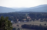
The St. Francois Mountains in southeast Missouri
are a range of Precambrian
igneous
mountains rising over the Ozark Plateau
. This range is one of the oldest exposures of igneous rock
in North America.
The name of the range is spelled out as Saint Francois Mountains in official GNIS sources, but it is sometimes misspelled in use as St. Francis Mountains to match the anglicized pronunciation of both the range and St. Francois County.http://adsabs.harvard.edu/abs/1962JGR....67.4011Thttp://libraryphoto.cr.usgs.gov/cgi-bin/show_picture.cgi?ID=ID.%20Hamilton,%20W.B.%201329cthttp://pubs.usgs.gov/pp/p1183/pp1183.html
, which originates in the St. Francois Mountains. The origin of the river's name, which also was originally spelled "Francois" in the French manner
, is unclear. The area, as part of the Louisiana
district of New France
, is near some of the earliest French settlements in Missouri where many French place names survive. Some source conjecture that the name honors St. Francis of Assisi
, the patron saint of the Franciscan
order, but none of the region's early explorers were Franciscans. Others propose that Jacques Marquette
, a French
Jesuit, named the river when he explored its mouth in present-day Arkansas
in 1673. Before his voyage down the Mississippi Marquette had spent some time at the mission of St. Francois Xavier, named for the Jesuit missionary Francis Xavier
. The spelling of the river's name shifted from "Francois" to "Francis" in the early 20th century.
started forming about 460 million years ago, and the Rockies
a mere 140 million years ago. When the Appalachians started forming, the St. Francois range was already twice as old as the Appalachians are today.
The intrusive rocks of the area are composed of three types: subvolcanic
massifs, ring intrusions and central pluton
s.
The massifs are equivalent to the associated rhyolite
volcanics. They are granite
with granophyric
quartz
, perthitic
potassium feldspar
, biotite
and magnetite
. They are intrusive into the rhyolites with development of fine grained granophyre at the contact. At depth they exhibit a coarce grained rapakivi texture.
The subvolcanic granites are the most widespread igneous rocks and were thought to have been covered with extensive volcanics that have been removed by erosion.
The ring intrusives are high silica bodies which were intruded along ring faults associated with caldera
collapse. Rock types include trachyandesite
, trachyte
, syenite
and amphibole
- biotite granite. They are commonly porphyritic
.
The central plutons are highly evolved two mica
(contain both biotite and muscovite
) granites. Distinctive accessory minerals include: fluorite
, topaz
, apatite
, spinel
, allanite
, sphene and cassiterite
. They are enriched in tin
, lithium
, beryllium
, rubidium
, barium
, yttrium
, niobium
, uranium
, thorium
and fluorine
and are referred to as "tin granites'. Their circular to oval shape in plan view is consistent with emplacement within resurgent cauleras.
The exposed igneous rocks of the St. Francois are surrounded at depth by the slightly younger (~100 my) widely distributed igneous Spavinaw terrane
. The Spavinaw rocks are intersected in drill core across southern Missouri, southern Illinois, northern Arkansas, southern Kansas and northeastern Oklahoma. The Spavinaw rocks occur in outcrop only near Spavinaw, Oklahoma
. The rhyolites and ash flow
tuff
s of the Spavinaw are essentially identical to the volcanics of the St. Francois mountains (the Washington County volcanics).
The Saint Francois Mountains were formed by igneous activity, whereas most of the surrounding Ozarks are developed on Paleozoic
sedimentary rock
s as a dissected plateau
. The localized vertical relief was caused by erosion
following uplift
during the Pennsylvanian
and Permian
periods produced by the Ouachita orogeny
to the south. Elevations and strata
dips
in the Ozark structural
dome
generally radiate downward and outward away from the Saint Francois mountains.
These ancient mountains may be the only area in the American Midwest never to have been submerged, existing as an island archipelago
in the Paleozoic
seas. Fossil
ized coral
, the remains of ancient reef
s, can be found among the rocks
around the flanks of the mountains. These ancient reef complexes formed the localizing structures for the mineralizing fluids that resulted in the rich ore
deposits of the area.
, a mining
region yielding lead
, iron
, baryte, zinc
, silver
, manganese
, cobalt
, and nickel
ores. Historic Mine La Motte
near Fredericktown
was the site of lead mining activity by the French
as early as 1720. The area today accounts for over 90% of primary lead production in the United States.
Granite
has been commercially quarried since 1869 in the vicinity of Elephant Rocks State Park
, a tor with huge weathered granite bolders. The red architectural granite quarried in the area has been used in buildings in St. Louis and other areas in the country. It is currently marketed as Missouri Red monument stone
.
, the same process that formed Devils Tower
in Wyoming
and the Giant's Causeway
in Ireland
. The columnar jointing in this area is called the
Devil's Honeycomb
.
, Bell Mountain
, Proffit Mountain
, Pilot Knob, Hughes Mountain
, Goggin Mountain and Lead Hill Mountain. The elevations range from 500 feet to 1,772 feet (167 to 540 meters). Taum Sauk Mountain is the highest peak in the range, and the highest point in the state, with an elevation of 1772 ft. (540 m). In the southernmost reaches of the range is Clark Mountain, elevation 1450 ft. (441 m), with the distinction of being the highest isolated point in the range and in the state; it reaches its top from surrounding terrain of about 600 ft. (182 m) in less than two miles (3.2 km). Black Mountain, in Madison County, has the highest rise in elevation from its base, along the St. Francis River (540 feet above sea level) to its summit (1,502 feet above sea level), a rise of just under 1,000 feet in elevation.
s – Johnson's Shut-Ins
, Taum Sauk Mountain
, St. Joe
, Sam A. Baker
and Elephant Rocks
– are located in this region. Public land
s held by the Missouri Department of Conservation
provide access for hiking
, backpacking
, hunting
, fishing
, canoeing
, and boating
. The Mark Twain National Forest
contains additional public lands, including the Bell Mountain Wilderness
. A section of the Ozark Trail
winds through parts of the St. Francois Mountains, including a popular segment that crosses Taum Sauk and Proffit mountains.
The St. Francis River
in this area is a whitewater
stream in the spring when water levels are up, and it has hosted the Missouri Whitewater Championships annually since 1967.
Missouri
Missouri is a US state located in the Midwestern United States, bordered by Iowa, Illinois, Kentucky, Tennessee, Arkansas, Oklahoma, Kansas and Nebraska. With a 2010 population of 5,988,927, Missouri is the 18th most populous state in the nation and the fifth most populous in the Midwest. It...
are a range of Precambrian
Precambrian
The Precambrian is the name which describes the large span of time in Earth's history before the current Phanerozoic Eon, and is a Supereon divided into several eons of the geologic time scale...
igneous
Igneous rock
Igneous rock is one of the three main rock types, the others being sedimentary and metamorphic rock. Igneous rock is formed through the cooling and solidification of magma or lava...
mountains rising over the Ozark Plateau
The Ozarks
The Ozarks are a physiographic and geologic highland region of the central United States. It covers much of the southern half of Missouri and an extensive portion of northwestern and north central Arkansas...
. This range is one of the oldest exposures of igneous rock
Rock (geology)
In geology, rock or stone is a naturally occurring solid aggregate of minerals and/or mineraloids.The Earth's outer solid layer, the lithosphere, is made of rock. In general rocks are of three types, namely, igneous, sedimentary, and metamorphic...
in North America.
The name of the range is spelled out as Saint Francois Mountains in official GNIS sources, but it is sometimes misspelled in use as St. Francis Mountains to match the anglicized pronunciation of both the range and St. Francois County.http://adsabs.harvard.edu/abs/1962JGR....67.4011Thttp://libraryphoto.cr.usgs.gov/cgi-bin/show_picture.cgi?ID=ID.%20Hamilton,%20W.B.%201329cthttp://pubs.usgs.gov/pp/p1183/pp1183.html
Name
The name of the range derives from the St. Francis RiverSt. Francis River
The Saint Francis River is a tributary of the Mississippi River, about long, in southeastern Missouri and northeastern Arkansas in the United States...
, which originates in the St. Francois Mountains. The origin of the river's name, which also was originally spelled "Francois" in the French manner
French orthography
French orthography encompasses the spelling and punctuation of the French language. It is based on a combination of phonemic and historical principles. The spelling of words is largely based on the pronunciation of Old French c. 1100–1200 CE and has stayed more or less the same since then, despite...
, is unclear. The area, as part of the Louisiana
Louisiana (New France)
Louisiana or French Louisiana was an administrative district of New France. Under French control from 1682–1763 and 1800–03, the area was named in honor of Louis XIV, by French explorer René-Robert Cavelier, Sieur de la Salle...
district of New France
New France
New France was the area colonized by France in North America during a period beginning with the exploration of the Saint Lawrence River by Jacques Cartier in 1534 and ending with the cession of New France to Spain and Great Britain in 1763...
, is near some of the earliest French settlements in Missouri where many French place names survive. Some source conjecture that the name honors St. Francis of Assisi
Francis of Assisi
Saint Francis of Assisi was an Italian Catholic friar and preacher. He founded the men's Franciscan Order, the women’s Order of St. Clare, and the lay Third Order of Saint Francis. St...
, the patron saint of the Franciscan
Franciscan
Most Franciscans are members of Roman Catholic religious orders founded by Saint Francis of Assisi. Besides Roman Catholic communities, there are also Old Catholic, Anglican, Lutheran, ecumenical and Non-denominational Franciscan communities....
order, but none of the region's early explorers were Franciscans. Others propose that Jacques Marquette
Jacques Marquette
Father Jacques Marquette S.J. , sometimes known as Père Marquette, was a French Jesuit missionary who founded Michigan's first European settlement, Sault Ste. Marie, and later founded St. Ignace, Michigan...
, a French
French people
The French are a nation that share a common French culture and speak the French language as a mother tongue. Historically, the French population are descended from peoples of Celtic, Latin and Germanic origin, and are today a mixture of several ethnic groups...
Jesuit, named the river when he explored its mouth in present-day Arkansas
Arkansas
Arkansas is a state located in the southern region of the United States. Its name is an Algonquian name of the Quapaw Indians. Arkansas shares borders with six states , and its eastern border is largely defined by the Mississippi River...
in 1673. Before his voyage down the Mississippi Marquette had spent some time at the mission of St. Francois Xavier, named for the Jesuit missionary Francis Xavier
Francis Xavier
Francis Xavier, born Francisco de Jasso y Azpilicueta was a pioneering Roman Catholic missionary born in the Kingdom of Navarre and co-founder of the Society of Jesus. He was a student of Saint Ignatius of Loyola and one of the first seven Jesuits, dedicated at Montmartre in 1534...
. The spelling of the river's name shifted from "Francois" to "Francis" in the early 20th century.
Geology
Formed through volcanic and intrusive activity 1.485 billion (1.485 x 10⁹) years ago. By comparison, the AppalachiansAppalachian Mountains
The Appalachian Mountains #Whether the stressed vowel is or ,#Whether the "ch" is pronounced as a fricative or an affricate , and#Whether the final vowel is the monophthong or the diphthong .), often called the Appalachians, are a system of mountains in eastern North America. The Appalachians...
started forming about 460 million years ago, and the Rockies
Rocky Mountains
The Rocky Mountains are a major mountain range in western North America. The Rocky Mountains stretch more than from the northernmost part of British Columbia, in western Canada, to New Mexico, in the southwestern United States...
a mere 140 million years ago. When the Appalachians started forming, the St. Francois range was already twice as old as the Appalachians are today.
The intrusive rocks of the area are composed of three types: subvolcanic
Subvolcanic rock
A subvolcanic rock, also known as a hypabyssal rock, is an igneous rock that originates at medium to shallow depths within the crust and contain intermediate grain size and often porphyritic texture. They have textures between volcanic and plutonic rocks. Subvolcanic rocks include diabase and...
massifs, ring intrusions and central pluton
Pluton
A pluton in geology is a body of intrusive igneous rock that crystallized from magma slowly cooling below the surface of the Earth. Plutons include batholiths, dikes, sills, laccoliths, lopoliths, and other igneous bodies...
s.
The massifs are equivalent to the associated rhyolite
Rhyolite
This page is about a volcanic rock. For the ghost town see Rhyolite, Nevada, and for the satellite system, see Rhyolite/Aquacade.Rhyolite is an igneous, volcanic rock, of felsic composition . It may have any texture from glassy to aphanitic to porphyritic...
volcanics. They are granite
Granite
Granite is a common and widely occurring type of intrusive, felsic, igneous rock. Granite usually has a medium- to coarse-grained texture. Occasionally some individual crystals are larger than the groundmass, in which case the texture is known as porphyritic. A granitic rock with a porphyritic...
with granophyric
Granophyre
Granophyre is a subvolcanic rock that contains quartz and alkali feldspar in characteristic angular intergrowths such as those in the accompanying image....
quartz
Quartz
Quartz is the second-most-abundant mineral in the Earth's continental crust, after feldspar. It is made up of a continuous framework of SiO4 silicon–oxygen tetrahedra, with each oxygen being shared between two tetrahedra, giving an overall formula SiO2. There are many different varieties of quartz,...
, perthitic
Perthite
Perthite is used to describe an intergrowth of two feldspars: a host grain of potassium-rich alkali feldspar includes exsolved lamellae or irregular intergrowths of sodic alkali feldspar . Typically the host grain is orthoclase or microcline, and the lamellae are albite...
potassium feldspar
Feldspar
Feldspars are a group of rock-forming tectosilicate minerals which make up as much as 60% of the Earth's crust....
, biotite
Biotite
Biotite is a common phyllosilicate mineral within the mica group, with the approximate chemical formula . More generally, it refers to the dark mica series, primarily a solid-solution series between the iron-endmember annite, and the magnesium-endmember phlogopite; more aluminous endmembers...
and magnetite
Magnetite
Magnetite is a ferrimagnetic mineral with chemical formula Fe3O4, one of several iron oxides and a member of the spinel group. The chemical IUPAC name is iron oxide and the common chemical name is ferrous-ferric oxide. The formula for magnetite may also be written as FeO·Fe2O3, which is one part...
. They are intrusive into the rhyolites with development of fine grained granophyre at the contact. At depth they exhibit a coarce grained rapakivi texture.
The subvolcanic granites are the most widespread igneous rocks and were thought to have been covered with extensive volcanics that have been removed by erosion.
The ring intrusives are high silica bodies which were intruded along ring faults associated with caldera
Caldera
A caldera is a cauldron-like volcanic feature usually formed by the collapse of land following a volcanic eruption, such as the one at Yellowstone National Park in the US. They are sometimes confused with volcanic craters...
collapse. Rock types include trachyandesite
Trachyandesite
Trachyandesite is an extrusive igneous rock. It has little or no free quartz, but is dominated by alkali feldspar and sodic plagioclase along with one or more of the following mafic minerals: amphibole, biotite or pyroxene...
, trachyte
Trachyte
Trachyte is an igneous volcanic rock with an aphanitic to porphyritic texture. The mineral assemblage consists of essential alkali feldspar; relatively minor plagioclase and quartz or a feldspathoid such as nepheline may also be present....
, syenite
Syenite
Syenite is a coarse-grained intrusive igneous rock of the same general composition as granite but with the quartz either absent or present in relatively small amounts Syenite is a coarse-grained intrusive igneous rock of the same general composition as granite but with the quartz either absent or...
and amphibole
Amphibole
Amphibole is the name of an important group of generally dark-colored rock-forming inosilicate minerals, composed of double chain tetrahedra, linked at the vertices and generally containing ions of iron and/or magnesium in their structures.-Mineralogy:...
- biotite granite. They are commonly porphyritic
Porphyritic
Porphyritic is an adjective used in geology, specifically for igneous rocks, for a rock that has a distinct difference in the size of the crystals, with at least one group of crystals obviously larger than another group...
.
The central plutons are highly evolved two mica
Mica
The mica group of sheet silicate minerals includes several closely related materials having highly perfect basal cleavage. All are monoclinic, with a tendency towards pseudohexagonal crystals, and are similar in chemical composition...
(contain both biotite and muscovite
Muscovite
Muscovite is a phyllosilicate mineral of aluminium and potassium with formula KAl22, or 236. It has a highly-perfect basal cleavage yielding remarkably-thin laminæ which are often highly elastic...
) granites. Distinctive accessory minerals include: fluorite
Fluorite
Fluorite is a halide mineral composed of calcium fluoride, CaF2. It is an isometric mineral with a cubic habit, though octahedral and more complex isometric forms are not uncommon...
, topaz
Topaz
Topaz is a silicate mineral of aluminium and fluorine with the chemical formula Al2SiO42. Topaz crystallizes in the orthorhombic system and its crystals are mostly prismatic terminated by pyramidal and other faces.-Color and varieties:...
, apatite
Apatite
Apatite is a group of phosphate minerals, usually referring to hydroxylapatite, fluorapatite, chlorapatite and bromapatite, named for high concentrations of OH−, F−, Cl− or Br− ions, respectively, in the crystal...
, spinel
Spinel
Spinel is the magnesium aluminium member of the larger spinel group of minerals. It has the formula MgAl2O4. Balas ruby is an old name for a rose-tinted variety.-Spinel group:...
, allanite
Allanite
Allanite is a sorosilicate group of minerals within the broader epidote group that contain a significant amount of rare earth elements. The mineral occurs mainly in metamorphosed clay rich sediments and felsic igneous rocks...
, sphene and cassiterite
Cassiterite
Cassiterite is a tin oxide mineral, SnO2. It is generally opaque, but it is translucent in thin crystals. Its luster and multiple crystal faces produce a desirable gem...
. They are enriched in tin
Tin
Tin is a chemical element with the symbol Sn and atomic number 50. It is a main group metal in group 14 of the periodic table. Tin shows chemical similarity to both neighboring group 14 elements, germanium and lead and has two possible oxidation states, +2 and the slightly more stable +4...
, lithium
Lithium
Lithium is a soft, silver-white metal that belongs to the alkali metal group of chemical elements. It is represented by the symbol Li, and it has the atomic number 3. Under standard conditions it is the lightest metal and the least dense solid element. Like all alkali metals, lithium is highly...
, beryllium
Beryllium
Beryllium is the chemical element with the symbol Be and atomic number 4. It is a divalent element which occurs naturally only in combination with other elements in minerals. Notable gemstones which contain beryllium include beryl and chrysoberyl...
, rubidium
Rubidium
Rubidium is a chemical element with the symbol Rb and atomic number 37. Rubidium is a soft, silvery-white metallic element of the alkali metal group. Its atomic mass is 85.4678. Elemental rubidium is highly reactive, with properties similar to those of other elements in group 1, such as very rapid...
, barium
Barium
Barium is a chemical element with the symbol Ba and atomic number 56. It is the fifth element in Group 2, a soft silvery metallic alkaline earth metal. Barium is never found in nature in its pure form due to its reactivity with air. Its oxide is historically known as baryta but it reacts with...
, yttrium
Yttrium
Yttrium is a chemical element with symbol Y and atomic number 39. It is a silvery-metallic transition metal chemically similar to the lanthanides and it has often been classified as a "rare earth element". Yttrium is almost always found combined with the lanthanides in rare earth minerals and is...
, niobium
Niobium
Niobium or columbium , is a chemical element with the symbol Nb and atomic number 41. It's a soft, grey, ductile transition metal, which is often found in the pyrochlore mineral, the main commercial source for niobium, and columbite...
, uranium
Uranium
Uranium is a silvery-white metallic chemical element in the actinide series of the periodic table, with atomic number 92. It is assigned the chemical symbol U. A uranium atom has 92 protons and 92 electrons, of which 6 are valence electrons...
, thorium
Thorium
Thorium is a natural radioactive chemical element with the symbol Th and atomic number 90. It was discovered in 1828 and named after Thor, the Norse god of thunder....
and fluorine
Fluorine
Fluorine is the chemical element with atomic number 9, represented by the symbol F. It is the lightest element of the halogen column of the periodic table and has a single stable isotope, fluorine-19. At standard pressure and temperature, fluorine is a pale yellow gas composed of diatomic...
and are referred to as "tin granites'. Their circular to oval shape in plan view is consistent with emplacement within resurgent cauleras.
The exposed igneous rocks of the St. Francois are surrounded at depth by the slightly younger (~100 my) widely distributed igneous Spavinaw terrane
Spavinaw terrane
The Spavinaw terrane is an occurrence of Proterozoic intrusive and volcanic rocks in the mid-continent region of the United States. The terrane extends across southern Missouri, southern Kansas, northern Arkansas and much of Oklahoma...
. The Spavinaw rocks are intersected in drill core across southern Missouri, southern Illinois, northern Arkansas, southern Kansas and northeastern Oklahoma. The Spavinaw rocks occur in outcrop only near Spavinaw, Oklahoma
Spavinaw, Oklahoma
Spavinaw is a town in Mayes County, Oklahoma, United States. The population was 563 at the 2000 census. The town is best known as the birthplace of baseball player Mickey Mantle.-Geography:Spavinaw is located at ....
. The rhyolites and ash flow
Volcanic ash
Volcanic ash consists of small tephra, which are bits of pulverized rock and glass created by volcanic eruptions, less than in diameter. There are three mechanisms of volcanic ash formation: gas release under decompression causing magmatic eruptions; thermal contraction from chilling on contact...
tuff
Tuff
Tuff is a type of rock consisting of consolidated volcanic ash ejected from vents during a volcanic eruption. Tuff is sometimes called tufa, particularly when used as construction material, although tufa also refers to a quite different rock. Rock that contains greater than 50% tuff is considered...
s of the Spavinaw are essentially identical to the volcanics of the St. Francois mountains (the Washington County volcanics).
The Saint Francois Mountains were formed by igneous activity, whereas most of the surrounding Ozarks are developed on Paleozoic
Paleozoic
The Paleozoic era is the earliest of three geologic eras of the Phanerozoic eon, spanning from roughly...
sedimentary rock
Sedimentary rock
Sedimentary rock are types of rock that are formed by the deposition of material at the Earth's surface and within bodies of water. Sedimentation is the collective name for processes that cause mineral and/or organic particles to settle and accumulate or minerals to precipitate from a solution....
s as a dissected plateau
Dissected plateau
A dissected plateau is a plateau area that has been severely eroded so that the relief is sharp. Such an area may be referred to as mountainous, but dissected plateaus are distinguishable from orogenic mountain belts by the lack of folding, metamorphism, extensive faulting, or magmatic activity...
. The localized vertical relief was caused by erosion
Erosion
Erosion is when materials are removed from the surface and changed into something else. It only works by hydraulic actions and transport of solids in the natural environment, and leads to the deposition of these materials elsewhere...
following uplift
Tectonic uplift
Tectonic uplift is a geological process most often caused by plate tectonics which increases elevation. The opposite of uplift is subsidence, which results in a decrease in elevation. Uplift may be orogenic or isostatic.-Orogenic uplift:...
during the Pennsylvanian
Pennsylvanian
The Pennsylvanian is, in the ICS geologic timescale, the younger of two subperiods of the Carboniferous Period. It lasted from roughly . As with most other geochronologic units, the rock beds that define the Pennsylvanian are well identified, but the exact date of the start and end are uncertain...
and Permian
Permian
The PermianThe term "Permian" was introduced into geology in 1841 by Sir Sir R. I. Murchison, president of the Geological Society of London, who identified typical strata in extensive Russian explorations undertaken with Edouard de Verneuil; Murchison asserted in 1841 that he named his "Permian...
periods produced by the Ouachita orogeny
Ouachita orogeny
The Ouachita orogeny was a mountain building event that resulted in the folding and faulting of strata currently exposed in the Ouachita Mountains...
to the south. Elevations and strata
Stratum
In geology and related fields, a stratum is a layer of sedimentary rock or soil with internally consistent characteristics that distinguish it from other layers...
dips
Strike and dip
Strike and dip refer to the orientation or attitude of a geologic feature. The strike line of a bed, fault, or other planar feature is a line representing the intersection of that feature with a horizontal plane. On a geologic map, this is represented with a short straight line segment oriented...
in the Ozark structural
Structural geology
Structural geology is the study of the three-dimensional distribution of rock units with respect to their deformational histories. The primary goal of structural geology is to use measurements of present-day rock geometries to uncover information about the history of deformation in the rocks, and...
dome
Dome (geology)
In structural geology, a dome is a deformational feature consisting of symmetrically-dipping anticlines; their general outline on a geologic map is circular or oval...
generally radiate downward and outward away from the Saint Francois mountains.
These ancient mountains may be the only area in the American Midwest never to have been submerged, existing as an island archipelago
Archipelago
An archipelago , sometimes called an island group, is a chain or cluster of islands. The word archipelago is derived from the Greek ἄρχι- – arkhi- and πέλαγος – pélagos through the Italian arcipelago...
in the Paleozoic
Paleozoic
The Paleozoic era is the earliest of three geologic eras of the Phanerozoic eon, spanning from roughly...
seas. Fossil
Fossil
Fossils are the preserved remains or traces of animals , plants, and other organisms from the remote past...
ized coral
Coral
Corals are marine animals in class Anthozoa of phylum Cnidaria typically living in compact colonies of many identical individual "polyps". The group includes the important reef builders that inhabit tropical oceans and secrete calcium carbonate to form a hard skeleton.A coral "head" is a colony of...
, the remains of ancient reef
Reef
In nautical terminology, a reef is a rock, sandbar, or other feature lying beneath the surface of the water ....
s, can be found among the rocks
Rock (geology)
In geology, rock or stone is a naturally occurring solid aggregate of minerals and/or mineraloids.The Earth's outer solid layer, the lithosphere, is made of rock. In general rocks are of three types, namely, igneous, sedimentary, and metamorphic...
around the flanks of the mountains. These ancient reef complexes formed the localizing structures for the mineralizing fluids that resulted in the rich ore
Ore
An ore is a type of rock that contains minerals with important elements including metals. The ores are extracted through mining; these are then refined to extract the valuable element....
deposits of the area.
Mineral resources
The St. Francois Mountains are the center of the Lead BeltLead Belt
The Southeast Missouri Lead District, commonly called the Lead Belt, is a lead mining district in the southeastern part of Missouri. Counties in the Lead Belt include Saint Francois; Crawford; Dent; Iron; Madison: Reynolds; and Washington...
, a mining
Mining
Mining is the extraction of valuable minerals or other geological materials from the earth, from an ore body, vein or seam. The term also includes the removal of soil. Materials recovered by mining include base metals, precious metals, iron, uranium, coal, diamonds, limestone, oil shale, rock...
region yielding lead
Lead
Lead is a main-group element in the carbon group with the symbol Pb and atomic number 82. Lead is a soft, malleable poor metal. It is also counted as one of the heavy metals. Metallic lead has a bluish-white color after being freshly cut, but it soon tarnishes to a dull grayish color when exposed...
, iron
Iron
Iron is a chemical element with the symbol Fe and atomic number 26. It is a metal in the first transition series. It is the most common element forming the planet Earth as a whole, forming much of Earth's outer and inner core. It is the fourth most common element in the Earth's crust...
, baryte, zinc
Zinc
Zinc , or spelter , is a metallic chemical element; it has the symbol Zn and atomic number 30. It is the first element in group 12 of the periodic table. Zinc is, in some respects, chemically similar to magnesium, because its ion is of similar size and its only common oxidation state is +2...
, silver
Silver
Silver is a metallic chemical element with the chemical symbol Ag and atomic number 47. A soft, white, lustrous transition metal, it has the highest electrical conductivity of any element and the highest thermal conductivity of any metal...
, manganese
Manganese
Manganese is a chemical element, designated by the symbol Mn. It has the atomic number 25. It is found as a free element in nature , and in many minerals...
, cobalt
Cobalt
Cobalt is a chemical element with symbol Co and atomic number 27. It is found naturally only in chemically combined form. The free element, produced by reductive smelting, is a hard, lustrous, silver-gray metal....
, and nickel
Nickel
Nickel is a chemical element with the chemical symbol Ni and atomic number 28. It is a silvery-white lustrous metal with a slight golden tinge. Nickel belongs to the transition metals and is hard and ductile...
ores. Historic Mine La Motte
Mine La Motte, Missouri
Mine La Motte is an unincorporated community in Madison County, Missouri, United States. It is located about six miles north of Fredericktown. Europeans discovered lead here, and Antoine de la Mothe Cadillac brought several hundred workers, including slaves from Santo Domingo, to develop mines in...
near Fredericktown
Fredericktown, Missouri
Fredericktown is a city in and the county seat of Madison County, Missouri, United States, in the northeastern foothills of the Ozark Mountains. The population was 3,928 at the 2000 census...
was the site of lead mining activity by the French
France
The French Republic , The French Republic , The French Republic , (commonly known as France , is a unitary semi-presidential republic in Western Europe with several overseas territories and islands located on other continents and in the Indian, Pacific, and Atlantic oceans. Metropolitan France...
as early as 1720. The area today accounts for over 90% of primary lead production in the United States.
Granite
Granite
Granite is a common and widely occurring type of intrusive, felsic, igneous rock. Granite usually has a medium- to coarse-grained texture. Occasionally some individual crystals are larger than the groundmass, in which case the texture is known as porphyritic. A granitic rock with a porphyritic...
has been commercially quarried since 1869 in the vicinity of Elephant Rocks State Park
Elephant Rocks State Park
Elephant Rocks State Park in the U.S. state of Missouri encompasses an outcropping of Precambrian granite in the Saint Francois Mountains. It is named for a string of large granite boulders which resemble a train of pink circus elephants....
, a tor with huge weathered granite bolders. The red architectural granite quarried in the area has been used in buildings in St. Louis and other areas in the country. It is currently marketed as Missouri Red monument stone
Headstone
A headstone, tombstone, or gravestone is a marker, usually stone, that is placed over a grave. In most cases they have the deceased's name, date of birth, and date of death inscribed on them, along with a personal message, or prayer.- Use :...
.
Structural features
Hughes Mountain contains a good example of columnar jointing in igneous rhyoliteRhyolite
This page is about a volcanic rock. For the ghost town see Rhyolite, Nevada, and for the satellite system, see Rhyolite/Aquacade.Rhyolite is an igneous, volcanic rock, of felsic composition . It may have any texture from glassy to aphanitic to porphyritic...
, the same process that formed Devils Tower
Devils Tower National Monument
Devils Tower is an igneous intrusion or laccolith located in the Black Hills near Hulett and Sundance in Crook County, northeastern Wyoming, above the Belle Fourche River...
in Wyoming
Wyoming
Wyoming is a state in the mountain region of the Western United States. The western two thirds of the state is covered mostly with the mountain ranges and rangelands in the foothills of the Eastern Rocky Mountains, while the eastern third of the state is high elevation prairie known as the High...
and the Giant's Causeway
Giant's Causeway
The Giant's Causeway is an area of about 40,000 interlocking basalt columns, the result of an ancient volcanic eruption. It is located in County Antrim on the northeast coast of Northern Ireland, about three miles northeast of the town of Bushmills...
in Ireland
Ireland
Ireland is an island to the northwest of continental Europe. It is the third-largest island in Europe and the twentieth-largest island on Earth...
. The columnar jointing in this area is called the
Devil's Honeycomb
Hughes Mountain
Hughes Mountain and the Hughes Mountain State Natural Area are located in southern Washington County, Missouri just south of the Big River and Highway M on Cedar Creek Road in the St. Francois Mountains range of The Ozarks. The mountain reaches an elevation of 1,201 feet , rising 430 feet ...
.
Peaks
Mountains in this range include; Taum Sauk MountainTaum Sauk Mountain
Taum Sauk Mountain in the Saint Francois Mountains is the highest natural point in the U.S. state of Missouri, 1,772 feet above mean sea level.The topography of Taum Sauk is that of a somewhat flat ridge rather than a peak....
, Bell Mountain
Bell Mountain Wilderness
The United States Congress designated the Bell Mountain Wilderness in 1980. The wilderness area now has a total of . Bell Mountain is located within the Potosi-Fredericktown Ranger District of the Mark Twain National Forest, south of Potosi, Missouri in the United States...
, Proffit Mountain
Taum Sauk pumped storage plant
The Taum Sauk pumped storage plant is located in the St. Francois mountain region of the Missouri Ozarks approximately south of St. Louis near Lesterville, Missouri in Reynolds County. The pumped-storage hydroelectric plant, operated by the AmerenUE electric company, was designed to help...
, Pilot Knob, Hughes Mountain
Hughes Mountain
Hughes Mountain and the Hughes Mountain State Natural Area are located in southern Washington County, Missouri just south of the Big River and Highway M on Cedar Creek Road in the St. Francois Mountains range of The Ozarks. The mountain reaches an elevation of 1,201 feet , rising 430 feet ...
, Goggin Mountain and Lead Hill Mountain. The elevations range from 500 feet to 1,772 feet (167 to 540 meters). Taum Sauk Mountain is the highest peak in the range, and the highest point in the state, with an elevation of 1772 ft. (540 m). In the southernmost reaches of the range is Clark Mountain, elevation 1450 ft. (441 m), with the distinction of being the highest isolated point in the range and in the state; it reaches its top from surrounding terrain of about 600 ft. (182 m) in less than two miles (3.2 km). Black Mountain, in Madison County, has the highest rise in elevation from its base, along the St. Francis River (540 feet above sea level) to its summit (1,502 feet above sea level), a rise of just under 1,000 feet in elevation.
Recreation
Five Missouri state parkState park
State parks are parks or other protected areas managed at the federated state level within those nations which use "state" as a political subdivision. State parks are typically established by a state to preserve a location on account of its natural beauty, historic interest, or recreational...
s – Johnson's Shut-Ins
Johnson's Shut-Ins State Park
Johnson's Shut-Ins State Park is a Missouri state park on the East Fork Black River consisting of in Reynolds County. The park is jointly administered with adjoining Taum Sauk Mountain State Park, and together the two parks cover in the St...
, Taum Sauk Mountain
Taum Sauk Mountain State Park
Taum Sauk Mountain State Park is located in the Saint Francois Mountains in the Missouri Ozarks. It is centered around Taum Sauk Mountain, the highest point in the state....
, St. Joe
St. Joe State Park
St. Joe State Park is a Missouri state park located in Park Hills, Missouri on the flanks of the Saint Francois Mountains. It encompasses with a off-road vehicle riding area located on the old St. Joe mine tailings dumps. It also contains camping facilities and trails for hiking, bicycling, or...
, Sam A. Baker
Sam A. Baker State Park
Sam A. Baker State Park is located in the Saint Francois Mountain region of the Missouri Ozarks. The park offers access to the St. Francis River and Big Creek for fishing, canoeing, and swimming. The park has 187 campsites, half of them electric, and 18 rustic but air-conditioned cabins...
and Elephant Rocks
Elephant Rocks State Park
Elephant Rocks State Park in the U.S. state of Missouri encompasses an outcropping of Precambrian granite in the Saint Francois Mountains. It is named for a string of large granite boulders which resemble a train of pink circus elephants....
– are located in this region. Public land
Public land
In all modern states, some land is held by central or local governments. This is called public land. The system of tenure of public land, and the terminology used, varies between countries...
s held by the Missouri Department of Conservation
Missouri Department of Conservation
The Missouri Department of Conservation and the Missouri Conservation Commission were created by Article IV Sections 40-42 of the Missouri Constitution, which were adopted by the voters of the state in 1936 as Amendment 4 to the constitution...
provide access for hiking
Hiking
Hiking is an outdoor activity which consists of walking in natural environments, often in mountainous or other scenic terrain. People often hike on hiking trails. It is such a popular activity that there are numerous hiking organizations worldwide. The health benefits of different types of hiking...
, backpacking
Backpacking (wilderness)
Backpacking combines the activities of hiking and camping for an overnight stay in backcountry wilderness...
, hunting
Hunting
Hunting is the practice of pursuing any living thing, usually wildlife, for food, recreation, or trade. In present-day use, the term refers to lawful hunting, as distinguished from poaching, which is the killing, trapping or capture of the hunted species contrary to applicable law...
, fishing
Fishing
Fishing is the activity of trying to catch wild fish. Fish are normally caught in the wild. Techniques for catching fish include hand gathering, spearing, netting, angling and trapping....
, canoeing
Canoeing
Canoeing is an outdoor activity that involves a special kind of canoe.Open canoes may be 'poled' , sailed, 'lined and tracked' or even 'gunnel-bobbed'....
, and boating
Boating
Boating is the leisurely activity of travelling by boat, or the recreational use of a boat whether powerboats, sailboats, or man-powered vessels , focused on the travel itself, as well as sports activities, such as fishing or water skiing...
. The Mark Twain National Forest
Mark Twain National Forest
Mark Twain National Forest is a U.S. National Forest located in the southern half of Missouri. MTNF was established on September 11, 1939. It is named for author Mark Twain, a Missouri native. The MTNF covers approximately 1.5 million acres , 78,000 acres of which are Wilderness, and National...
contains additional public lands, including the Bell Mountain Wilderness
Bell Mountain Wilderness
The United States Congress designated the Bell Mountain Wilderness in 1980. The wilderness area now has a total of . Bell Mountain is located within the Potosi-Fredericktown Ranger District of the Mark Twain National Forest, south of Potosi, Missouri in the United States...
. A section of the Ozark Trail
Ozark Trail (hiking trail)
The Ozark Trail is a hiking, backpacking, and, in many places, biking and equestrian trail under construction in the Missouri Ozarks in the United States. It is intended to reach from St. Louis to Arkansas. Over of the trail have been completed as of 2008, and the estimated length when finished...
winds through parts of the St. Francois Mountains, including a popular segment that crosses Taum Sauk and Proffit mountains.
The St. Francis River
St. Francis River
The Saint Francis River is a tributary of the Mississippi River, about long, in southeastern Missouri and northeastern Arkansas in the United States...
in this area is a whitewater
Whitewater
Whitewater is formed in a rapid, when a river's gradient increases enough to disturb its laminar flow and create turbulence, i.e. form a bubbly, or aerated and unstable current; the frothy water appears white...
stream in the spring when water levels are up, and it has hosted the Missouri Whitewater Championships annually since 1967.
See also
- Geography of MissouriGeography of MissouriMissouri, a state near the geographical center of the United States, has three distinct physiographic divisions:* a north-western upland plain or prairie region part of the Interior Plains' Central Lowland known as the northern plains* a lowland in the extreme southeast bootheel region of...
- Missouri National and State Parks
- Taum Sauk pumped storage plantTaum Sauk pumped storage plantThe Taum Sauk pumped storage plant is located in the St. Francois mountain region of the Missouri Ozarks approximately south of St. Louis near Lesterville, Missouri in Reynolds County. The pumped-storage hydroelectric plant, operated by the AmerenUE electric company, was designed to help...