
Elephant Rocks State Park
Encyclopedia
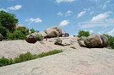
Elephant Rocks State Park in the U.S. state
of Missouri
encompasses an outcropping of Precambrian
granite
in the Saint Francois Mountains
. It is named for a string of large granite boulders which resemble a train of pink circus elephant
s.
The park has thirty picnic sites and a one mile (2 km) circular interpretive trail in the Elephant Rocks Natural Area. This trail is called the Braille Trail and is unique among Missouri state parks in being designed specifically for visitors with visual and physical handicaps. There are several spur trails which are not handicapped accessible. Each of these spur trails has its own unique feature. One spur passes through "Fat Man's Squeeze", a narrow gap between two boulders, leading hikers to the old quarry. Another spur goes through "The Maze" a 100-foot (30.48 meter) section of scattered boulders. Within the maze is a semi-enclosed area called "The Devil's Kitchen." There is no camping permitted at this park, but other state parks in the vicinity have camping facilities.
Geologically, Elephant Rocks State Park consists of a tor
, which is a high, isolated rocky peak, usually of jointed and weathered granite. The alkaline granite here was formed in the Proterozoic
1500 million years ago from a dome of molten magma
. Nearly vertical fractures formed in the stone as it cooled, and uplift of the formation enhanced the fracturing. Eventually the overlying strata
were removed through erosion
, exposing the granite dome
. With exposure, water and ice worked to weather
and erode the surface of the granite and to expand the fracture joints. Eons of weathering produced the rounded boulders that are the park's signature.
The reddish or pink granite has been quarried in this area since 1869, and two abandoned granite quarries
are within the park. These and others nearby have provided red architectural granite for buildings in states from Massachusetts
to California
, but most particularly in St. Louis
, including stone for St. Louis City Hall and the piers of the Eads Bridge
. Stones unsuitable for architectural use were made into shoebox-sized paving stones that were used on the streets of St. Louis as well as on its wharf
on the Mississippi River
. Stone quarried in the area currently is used for mortuary monuments
and is known commercially as Missouri Red monument stone.
U.S. state
A U.S. state is any one of the 50 federated states of the United States of America that share sovereignty with the federal government. Because of this shared sovereignty, an American is a citizen both of the federal entity and of his or her state of domicile. Four states use the official title of...
of Missouri
Missouri
Missouri is a US state located in the Midwestern United States, bordered by Iowa, Illinois, Kentucky, Tennessee, Arkansas, Oklahoma, Kansas and Nebraska. With a 2010 population of 5,988,927, Missouri is the 18th most populous state in the nation and the fifth most populous in the Midwest. It...
encompasses an outcropping of Precambrian
Precambrian
The Precambrian is the name which describes the large span of time in Earth's history before the current Phanerozoic Eon, and is a Supereon divided into several eons of the geologic time scale...
granite
Granite
Granite is a common and widely occurring type of intrusive, felsic, igneous rock. Granite usually has a medium- to coarse-grained texture. Occasionally some individual crystals are larger than the groundmass, in which case the texture is known as porphyritic. A granitic rock with a porphyritic...
in the Saint Francois Mountains
Saint Francois Mountains
The St. Francois Mountains in southeast Missouri are a range of Precambrian igneous mountains rising over the Ozark Plateau. This range is one of the oldest exposures of igneous rock in North America....
. It is named for a string of large granite boulders which resemble a train of pink circus elephant
Elephant
Elephants are large land mammals in two extant genera of the family Elephantidae: Elephas and Loxodonta, with the third genus Mammuthus extinct...
s.
The park has thirty picnic sites and a one mile (2 km) circular interpretive trail in the Elephant Rocks Natural Area. This trail is called the Braille Trail and is unique among Missouri state parks in being designed specifically for visitors with visual and physical handicaps. There are several spur trails which are not handicapped accessible. Each of these spur trails has its own unique feature. One spur passes through "Fat Man's Squeeze", a narrow gap between two boulders, leading hikers to the old quarry. Another spur goes through "The Maze" a 100-foot (30.48 meter) section of scattered boulders. Within the maze is a semi-enclosed area called "The Devil's Kitchen." There is no camping permitted at this park, but other state parks in the vicinity have camping facilities.
Geologically, Elephant Rocks State Park consists of a tor
Tor (geography)
A tor is a large, free-standing residual mass that rises abruptly from the surrounding smooth and gentle slopes of a rounded hill summit or ridge crest...
, which is a high, isolated rocky peak, usually of jointed and weathered granite. The alkaline granite here was formed in the Proterozoic
Proterozoic
The Proterozoic is a geological eon representing a period before the first abundant complex life on Earth. The name Proterozoic comes from the Greek "earlier life"...
1500 million years ago from a dome of molten magma
Magma
Magma is a mixture of molten rock, volatiles and solids that is found beneath the surface of the Earth, and is expected to exist on other terrestrial planets. Besides molten rock, magma may also contain suspended crystals and dissolved gas and sometimes also gas bubbles. Magma often collects in...
. Nearly vertical fractures formed in the stone as it cooled, and uplift of the formation enhanced the fracturing. Eventually the overlying strata
Stratum
In geology and related fields, a stratum is a layer of sedimentary rock or soil with internally consistent characteristics that distinguish it from other layers...
were removed through erosion
Erosion
Erosion is when materials are removed from the surface and changed into something else. It only works by hydraulic actions and transport of solids in the natural environment, and leads to the deposition of these materials elsewhere...
, exposing the granite dome
Granite dome
A granite dome is a dome of granite, formed by exfoliation.-Formation:Granite forms plutons of igneous rock several kilometers below the surface as magma slowly cools and crystallizes. The granite is under great overhead pressure....
. With exposure, water and ice worked to weather
Weathering
Weathering is the breaking down of rocks, soils and minerals as well as artificial materials through contact with the Earth's atmosphere, biota and waters...
and erode the surface of the granite and to expand the fracture joints. Eons of weathering produced the rounded boulders that are the park's signature.
The reddish or pink granite has been quarried in this area since 1869, and two abandoned granite quarries
Quarry
A quarry is a type of open-pit mine from which rock or minerals are extracted. Quarries are generally used for extracting building materials, such as dimension stone, construction aggregate, riprap, sand, and gravel. They are often collocated with concrete and asphalt plants due to the requirement...
are within the park. These and others nearby have provided red architectural granite for buildings in states from Massachusetts
Massachusetts
The Commonwealth of Massachusetts is a state in the New England region of the northeastern United States of America. It is bordered by Rhode Island and Connecticut to the south, New York to the west, and Vermont and New Hampshire to the north; at its east lies the Atlantic Ocean. As of the 2010...
to California
California
California is a state located on the West Coast of the United States. It is by far the most populous U.S. state, and the third-largest by land area...
, but most particularly in St. Louis
St. Louis, Missouri
St. Louis is an independent city on the eastern border of Missouri, United States. With a population of 319,294, it was the 58th-largest U.S. city at the 2010 U.S. Census. The Greater St...
, including stone for St. Louis City Hall and the piers of the Eads Bridge
Eads Bridge
The Eads Bridge is a combined road and railway bridge over the Mississippi River at St. Louis, connecting St. Louis and East St. Louis, Illinois....
. Stones unsuitable for architectural use were made into shoebox-sized paving stones that were used on the streets of St. Louis as well as on its wharf
Wharf
A wharf or quay is a structure on the shore of a harbor where ships may dock to load and unload cargo or passengers.Such a structure includes one or more berths , and may also include piers, warehouses, or other facilities necessary for handling the ships.A wharf commonly comprises a fixed...
on the Mississippi River
Mississippi River
The Mississippi River is the largest river system in North America. Flowing entirely in the United States, this river rises in western Minnesota and meanders slowly southwards for to the Mississippi River Delta at the Gulf of Mexico. With its many tributaries, the Mississippi's watershed drains...
. Stone quarried in the area currently is used for mortuary monuments
Headstone
A headstone, tombstone, or gravestone is a marker, usually stone, that is placed over a grave. In most cases they have the deceased's name, date of birth, and date of death inscribed on them, along with a personal message, or prayer.- Use :...
and is known commercially as Missouri Red monument stone.