
Rain shadow
Encyclopedia
Description
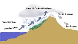
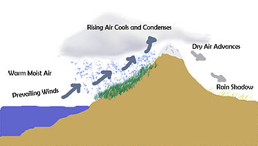
The condition exists because warm moist air rises through "orographic lifting" to the top of a mountain range or large mountain. Because of decreasing atmospheric pressure with increasing altitude, the air has expanded and adiabatically cooled to the point that the air reaches its adiabatic dew pointDew point
The dew point is the temperature to which a given parcel of humid air must be cooled, at constant barometric pressure, for water vapor to condense into liquid water. The condensed water is called dew when it forms on a solid surface. The dew point is a saturation temperature.The dew point is...
(which is not the same as its constant pressure
Isobaric process
An isobaric process is a thermodynamic process in which the pressure stays constant. The term derives from the Greek isos, , and barus,...
dew point commonly reported in weather forecasts). At the adiabatic dew point, moisture condenses onto the mountain and it precipitates
Precipitation (meteorology)
In meteorology, precipitation In meteorology, precipitation In meteorology, precipitation (also known as one of the classes of hydrometeors, which are atmospheric water phenomena is any product of the condensation of atmospheric water vapor that falls under gravity. The main forms of precipitation...
on the top and windward sides of the mountain. The air descends on the leeward side, but because of the process of precipitation, it has lost much of its initial moisture. Typically, descending air also gets warmer because of adiabatic compression (see Foehn winds) down the leeward side of the mountain, creating an arid
Arid
A region is said to be arid when it is characterized by a severe lack of available water, to the extent of hindering or even preventing the growth and development of plant and animal life...
region.
Regions of notable rain shadow

Prevailing winds
Prevailing winds are winds that blow predominantly from a single general direction over a particular point on Earth's surface. The dominant winds are the trends in direction of wind with the highest speed over a particular point on the Earth's surface. A region's prevailing and dominant winds...
found in bands round the Earth's equator
Equator
An equator is the intersection of a sphere's surface with the plane perpendicular to the sphere's axis of rotation and containing the sphere's center of mass....
ial region. The zone designated the trade winds is the zone between about 30° N and 30° S, blowing predominantly from the northeast in the Northern Hemisphere
Northern Hemisphere
The Northern Hemisphere is the half of a planet that is north of its equator—the word hemisphere literally means “half sphere”. It is also that half of the celestial sphere north of the celestial equator...
and from the southeast in the Southern Hemisphere
Southern Hemisphere
The Southern Hemisphere is the part of Earth that lies south of the equator. The word hemisphere literally means 'half ball' or "half sphere"...
. The westerlies
Westerlies
The Westerlies, anti-trades, or Prevailing Westerlies, are the prevailing winds in the middle latitudes between 30 and 60 degrees latitude, blowing from the high pressure area in the horse latitudes towards the poles. These prevailing winds blow from the west to the east, and steer extratropical...
are the prevailing winds in the middle latitudes
Middle latitudes
The middle latitudes are between 23°26'22" North and 66°33'39" North, and between 23°26'22" South and 66°33'39" South latitude, or, the Earth's temperate zones between the tropics and the Arctic and Antarctic. The prevailing winds in the middle latitudes are often very strong...
between 30 and 60 degrees latitude
Latitude
In geography, the latitude of a location on the Earth is the angular distance of that location south or north of the Equator. The latitude is an angle, and is usually measured in degrees . The equator has a latitude of 0°, the North pole has a latitude of 90° north , and the South pole has a...
, blowing predominantly from the southwest in the Northern Hemisphere and from the northwest in the Southern Hemisphere. The strongest westerly winds in the middle latitudes can come in the Roaring Forties
Roaring Forties
The Roaring Forties is the name given to strong westerly winds found in the Southern Hemisphere, generally between the latitudes of 40 and 49 degrees. Air displaced from the Equator towards the South Pole, which travels close to the surface between the latitudes of 30 and 60 degrees south, combines...
between 30 and 50 degrees latitude.
Examples of notable rain shadowing include:
Asia
- The peaks of the Caucasus MountainsCaucasus MountainsThe Caucasus Mountains is a mountain system in Eurasia between the Black Sea and the Caspian Sea in the Caucasus region .The Caucasus Mountains includes:* the Greater Caucasus Mountain Range and* the Lesser Caucasus Mountains....
to the west, the AlborzAlborzAlborz , also written as Alburz, Elburz or Elborz, is a mountain range in northern Iran stretching from the borders of Azerbaijan and Armenia in the northwest to the southern end of the Caspian Sea, and ending in the east at the borders of Turkmenistan and Afghanistan...
mountains to the south and the ranges tied to the Himalaya to the east rain shadow the Karakum and Kyzyl KumKyzyl KumThe Kyzyl Kum , also called Qyzylqum, is the 11th largest desert in the world. Its name means Red Sand in Turkic languages. It is located in Central Asia in the doab between the rivers Amu Darya and Syr Darya, and is divided between Kazakhstan, Uzbekistan and Turkmenistan...
deserts east of the Caspian SeaCaspian SeaThe Caspian Sea is the largest enclosed body of water on Earth by area, variously classed as the world's largest lake or a full-fledged sea. The sea has a surface area of and a volume of...
, as well as the semi-arid Kazakh SteppeKazakh SteppeThe Kazakh Steppe or Kirghiz Steppe ecoregion, of the Palearctic Temperate grasslands, savannas, and shrublands Biome, is a vast region of open grassland in northern Kazakhstan and adjacent portions of Russia, extending to the east of the Pontic steppe and to the west of the Emin Valley steppe,...
. - The Judean DesertJudean desertThe Judaean Desert is a desert in Israel and the West Bank that lies east of Jerusalem and descends to the Dead Sea. It stretches from the northeastern Negev to the east of Beit El, and is marked by terraces with escarpments. It ends in a steep escarpment dropping to the Dead Sea and the Jordan...
and the Dead SeaDead SeaThe Dead Sea , also called the Salt Sea, is a salt lake bordering Jordan to the east and Israel and the West Bank to the west. Its surface and shores are below sea level, the lowest elevation on the Earth's surface. The Dead Sea is deep, the deepest hypersaline lake in the world...
are rain shadowed by the Judean Hills. - The Dasht-i-Lut in Iran is in the rain shadow of the Elburz and Zagros MountainsZagros MountainsThe Zagros Mountains are the largest mountain range in Iran and Iraq. With a total length of 1,500 km , from northwestern Iran, and roughly correlating with Iran's western border, the Zagros range spans the whole length of the western and southwestern Iranian plateau and ends at the Strait of...
and is one of the most lifeless areas on Earth. - The Himalaya and connecting ranges also contribute to arid conditions in Central AsiaCentral AsiaCentral Asia is a core region of the Asian continent from the Caspian Sea in the west, China in the east, Afghanistan in the south, and Russia in the north...
including MongoliaMongoliaMongolia is a landlocked country in East and Central Asia. It is bordered by Russia to the north and China to the south, east and west. Although Mongolia does not share a border with Kazakhstan, its western-most point is only from Kazakhstan's eastern tip. Ulan Bator, the capital and largest...
's Gobi desert, as well as the semi-arid steppes of Mongolia and north-central to north western China. - The Ordos DesertOrdos DesertThe Ordos Desert is a desert and steppe region lying on a plateau in the south of the Inner Mongolian Autonomous Region of the People's Republic of China . The soil of the Ordos is a mixture of clay and sand and, as a result, is poorly suited for agriculture. It extends over an area of...
is rain shadowed by mountain chains including the Kara-naryn-ula, the Sheitenula, and the Yin MountainsYin MountainsThe Yin Mountains are mountains in the steppe forming the southern border of the eastern Gobi Desert of the Inner Mongolia Autonomous Region, as well as the northern part of Hebei province....
, which link on to the south end of the Great Khingan Mountains. - The Great Indian Desert or Thar desert is bounded and rain shadowed by the Aravalli ranges to the south-east, the Himalaya to the northeast, and the Kirthar and Sulaiman ranges to the west.
- Eastern Side of Sahyadri ranges on Deccan Plateau of India.
South America
- The Atacama DesertAtacama DesertThe Atacama Desert is a plateau in South America, covering a strip of land on the Pacific coast, west of the Andes mountains. It is, according to NASA, National Geographic and many other publications, the driest desert in the world...
in ChileChileChile ,officially the Republic of Chile , is a country in South America occupying a long, narrow coastal strip between the Andes mountains to the east and the Pacific Ocean to the west. It borders Peru to the north, Bolivia to the northeast, Argentina to the east, and the Drake Passage in the far...
is the driest non-AntarcticAntarcticThe Antarctic is the region around the Earth's South Pole, opposite the Arctic region around the North Pole. The Antarctic comprises the continent of Antarctica and the ice shelves, waters and island territories in the Southern Ocean situated south of the Antarctic Convergence...
desert on Earth because it is blocked from moisture on both sides (by the Andes Mountains to the east and high pressure over the PacificPacific OceanThe Pacific Ocean is the largest of the Earth's oceanic divisions. It extends from the Arctic in the north to the Southern Ocean in the south, bounded by Asia and Australia in the west, and the Americas in the east.At 165.2 million square kilometres in area, this largest division of the World...
at a latitude which keeps moisture from coming in from the west). - The Argentinian wine region of MendozaMendoza wineThe Mendoza Province is one of Argentina's most important wine regions, accounting for nearly two-thirds of the country's entire wine production. Located in the eastern foothills of the Andes, in the shadow of Mount Aconcagua, vineyards are planted at the some of the highest altitudes in the world...
is almost completely dependent on irrigation, using water drawn from the many rivers that drain glacial ice from the AndesAndesThe Andes is the world's longest continental mountain range. It is a continual range of highlands along the western coast of South America. This range is about long, about to wide , and of an average height of about .Along its length, the Andes is split into several ranges, which are separated...
. The nearby Chilean wine region of Valle CentralCentral Valley (wine region)In terms of viticulture the Central Valley of Chile spans the O'Higgins Region and Maule Region Administrative Regions and the Administrative Metropolitan Region, and is the main growing zone for Chilean wine and coincides with the historical core of the Chilean Central Valley.This is Chile's...
on the other hand, is situated on the Chilean side of the Andes and experiences a maritime climate. - PatagoniaPatagoniaPatagonia is a region located in Argentina and Chile, integrating the southernmost section of the Andes mountains to the southwest towards the Pacific ocean and from the east of the cordillera to the valleys it follows south through Colorado River towards Carmen de Patagones in the Atlantic Ocean...
is rain shadowed from the prevailing westerly winds by the AndesAndesThe Andes is the world's longest continental mountain range. It is a continual range of highlands along the western coast of South America. This range is about long, about to wide , and of an average height of about .Along its length, the Andes is split into several ranges, which are separated...
range and is arid (e.g., in Santa Cruz few spots are capable of cultivation, the pastures being poor, water insufficient and salt lagoons fairly numerous). - The Guajira PeninsulaGuajira PeninsulaGuajira Peninsula , is a peninsula in northern Colombia and northwestern Venezuela in the Caribbean Sea...
in northern Colombia is in the rain shadow of the Sierra Nevada de Santa MartaSierra Nevada de Santa MartaThe Sierra Nevada de Santa Marta is an isolated mountain range apart from the Andes chain that runs through Colombia. Reaching an altitude of 5,700 metres above sea level just 42 km from the Caribbean coast, the Sierra Nevada is the world's highest coastal range...
and despite its tropical latitude is almost arid, receiving almost no rainfall for seven to eight months of the year and being incapable of cultivation without irrigation.
North America
Most rainshadows in the western United StatesUnited States
The United States of America is a federal constitutional republic comprising fifty states and a federal district...
are due to mountain ranges, notably the Sierra Nevada and Cascades, that intercept rain and snowfall that would otherwise reach a valley in the lee of the mid-latitude prevailing westerlies.
- The desertDesertA desert is a landscape or region that receives an extremely low amount of precipitation, less than enough to support growth of most plants. Most deserts have an average annual precipitation of less than...
s of the Basin and Range Province in the United StatesUnited StatesThe United States of America is a federal constitutional republic comprising fifty states and a federal district...
and MexicoMexicoThe United Mexican States , commonly known as Mexico , is a federal constitutional republic in North America. It is bordered on the north by the United States; on the south and west by the Pacific Ocean; on the southeast by Guatemala, Belize, and the Caribbean Sea; and on the east by the Gulf of...
, which includes the dry areas east of the Cascade MountainsCascade RangeThe Cascade Range is a major mountain range of western North America, extending from southern British Columbia through Washington and Oregon to Northern California. It includes both non-volcanic mountains, such as the North Cascades, and the notable volcanoes known as the High Cascades...
of OregonOregonOregon is a state in the Pacific Northwest region of the United States. It is located on the Pacific coast, with Washington to the north, California to the south, Nevada on the southeast and Idaho to the east. The Columbia and Snake rivers delineate much of Oregon's northern and eastern...
and Washington and the Great BasinGreat BasinThe Great Basin is the largest area of contiguous endorheic watersheds in North America and is noted for its arid conditions and Basin and Range topography that varies from the North American low point at Badwater Basin to the highest point of the contiguous United States, less than away at the...
, which covers almost all of NevadaNevadaNevada is a state in the western, mountain west, and southwestern regions of the United States. With an area of and a population of about 2.7 million, it is the 7th-largest and 35th-most populous state. Over two-thirds of Nevada's people live in the Las Vegas metropolitan area, which contains its...
and parts of UtahUtahUtah is a state in the Western United States. It was the 45th state to join the Union, on January 4, 1896. Approximately 80% of Utah's 2,763,885 people live along the Wasatch Front, centering on Salt Lake City. This leaves vast expanses of the state nearly uninhabited, making the population the...
are rain shadowed. - The dry precipitation regime of the Great PlainsGreat PlainsThe Great Plains are a broad expanse of flat land, much of it covered in prairie, steppe and grassland, which lies west of the Mississippi River and east of the Rocky Mountains in the United States and Canada. This area covers parts of the U.S...
of Western CanadaWestern CanadaWestern Canada, also referred to as the Western provinces and commonly as the West, is a region of Canada that includes the four provinces west of the province of Ontario.- Provinces :...
and the central USA can be attributed in large part to the rain shadow of the North American CordilleraNorth American CordilleraThe North American Cordillera is the North American portion of the American Cordillera which is a cordillera extending up and down the western side of the Americas. The North American Cordillera covers an extensive area of mountain ranges, intermontane basins, and plateaus in western North...
. - The MojaveMojave DesertThe Mojave Desert occupies a significant portion of southeastern California and smaller parts of central California, southern Nevada, southwestern Utah and northwestern Arizona, in the United States...
, Black RockBlack Rock DesertThe Black Rock Desert is an arid region in the northern Nevada section of the Great Basin with a lakebed that is a dry remnant of Pleistocene Lake Lahontan...
, SonoranSonoran DesertThe Sonoran Desert is a North American desert which straddles part of the United States-Mexico border and covers large parts of the U.S. states of Arizona and California and the northwest Mexican states of Sonora, Baja California, and Baja California Sur. It is one of the largest and hottest...
, and ChihuahuanChihuahuan DesertThe Chihuahuan Desert is a desert, and an ecoregion designation, that straddles the U.S.-Mexico border in the central and northern portions of the Mexican Plateau, bordered on the west by the extensive Sierra Madre Occidental range, and overlaying northern portions of the east range, the Sierra...
deserts all are in regions which are rain shadowed. - The aptly named Death ValleyDeath ValleyDeath Valley is a desert valley located in Eastern California. Situated within the Mojave Desert, it features the lowest, driest, and hottest locations in North America. Badwater, a basin located in Death Valley, is the specific location of the lowest elevation in North America at 282 feet below...
in the United States, behind both the Pacific Coast RangesPacific Coast RangesThe Pacific Coast Ranges and the Pacific Mountain System are the series of mountain ranges that stretch along the West Coast of North America from Alaska south to Northern and Central Mexico...
of CaliforniaCaliforniaCalifornia is a state located on the West Coast of the United States. It is by far the most populous U.S. state, and the third-largest by land area...
and the Sierra Nevada range, is one of the driest places on the planetPlanetA planet is a celestial body orbiting a star or stellar remnant that is massive enough to be rounded by its own gravity, is not massive enough to cause thermonuclear fusion, and has cleared its neighbouring region of planetesimals.The term planet is ancient, with ties to history, science,...
. - The Colorado Front RangeColorado Front RangeThe Colorado Front Range is a colloquial geographic term for the most populous region of the state of Colorado in the United States. The area is located just east of the foothills of the Front Range, aligned in a north-south configuration on the western edge of the Great Plains, where they meet the...
is limited to the rainfall that makes it over the continental divideContinental divideA continental divide is a drainage divide on a continent such that the drainage basin on one side of the divide feeds into one ocean or sea, and the basin on the other side either feeds into a different ocean or sea, or else is endorheic, not connected to the open sea...
. While many places west of the divide receive as much as 40 inches (1,016 mm) of precipitation throughout the year, some places on the east side, notably Evergreen, ColoradoEvergreen, ColoradoEvergreen is a census-designated place and a U.S. Post Office in Jefferson County, Colorado, United States. Evergreen is roughly west of Denver. The population was 9,038 at the 2010 census...
and Denver, ColoradoDenver, ColoradoThe City and County of Denver is the capital and the most populous city of the U.S. state of Colorado. Denver is a consolidated city-county, located in the South Platte River Valley on the western edge of the High Plains just east of the Front Range of the Rocky Mountains...
only receive about 17-19 inches. Thus, the continental divideContinental divideA continental divide is a drainage divide on a continent such that the drainage basin on one side of the divide feeds into one ocean or sea, and the basin on the other side either feeds into a different ocean or sea, or else is endorheic, not connected to the open sea...
acts as a barrier for the precipitation. This effect only applies to west to east storms. When low pressure areas skirt the Rocky MountainsRocky MountainsThe Rocky Mountains are a major mountain range in western North America. The Rocky Mountains stretch more than from the northernmost part of British Columbia, in western Canada, to New Mexico, in the southwestern United States...
to the south, they can give high precipitation to the east side and none to the west side. This happens rarely. - The Rocky Mountain Front Range in Montana shows areas of limited precipitation as long as the systems passing over the mountain range come from the west. The clouds will dry out considerably by the time they reach the peaks of the mountain range.
- The east slopes of the Coast Ranges in central and southern California also cut off the southern San Joaquin ValleySan Joaquin ValleyThe San Joaquin Valley is the area of the Central Valley of California that lies south of the Sacramento – San Joaquin River Delta in Stockton...
from enough precipitation to ensure desert-like conditions in areas around BakersfieldBakersfield, CaliforniaBakersfield is a city near the southern end of the San Joaquin Valley in Kern County, California. It is roughly equidistant between Fresno and Los Angeles, to the north and south respectively....
. - The areas to the east of the Coast MountainsCoast MountainsThe Coast Mountains are a major mountain range, in the Pacific Coast Ranges, of western North America, extending from southwestern Yukon through the Alaska Panhandle and virtually all of the Coast of British Columbia. They are so-named because of their proximity to the sea coast, and are often...
and the Cascade RangeCascade RangeThe Cascade Range is a major mountain range of western North America, extending from southern British Columbia through Washington and Oregon to Northern California. It includes both non-volcanic mountains, such as the North Cascades, and the notable volcanoes known as the High Cascades...
in the province of British ColumbiaBritish ColumbiaBritish Columbia is the westernmost of Canada's provinces and is known for its natural beauty, as reflected in its Latin motto, Splendor sine occasu . Its name was chosen by Queen Victoria in 1858...
, CanadaCanadaCanada is a North American country consisting of ten provinces and three territories. Located in the northern part of the continent, it extends from the Atlantic Ocean in the east to the Pacific Ocean in the west, and northward into the Arctic Ocean...
and the American states of Washington, OregonOregonOregon is a state in the Pacific Northwest region of the United States. It is located on the Pacific coast, with Washington to the north, California to the south, Nevada on the southeast and Idaho to the east. The Columbia and Snake rivers delineate much of Oregon's northern and eastern...
and IdahoIdahoIdaho is a state in the Rocky Mountain area of the United States. The state's largest city and capital is Boise. Residents are called "Idahoans". Idaho was admitted to the Union on July 3, 1890, as the 43rd state....
are located in a rain shadow. - The Dungeness Valley around Sequim, Washington lies in the rain shadow of the Olympic MountainsOlympic MountainsThe Olympic Mountains is a mountain range on the Olympic Peninsula of western Washington in the United States. The mountains, part of the Pacific Coast Ranges, are not especially high - Mount Olympus is the highest at - but the western slopes of the Olympics rise directly out of the Pacific...
. The area averages 10–15 inches of rain per year, less than half of the amount received in nearby Port Angeles and approximately 10% of that which falls in ForksForks, Washington-Government:The City is organized under Washington State law as a Non-charter Code City. Its structure is that of an elected Mayor and a five member elected City Council...
on the western side of the mountains. - The effect appears even in the eastern United States. Although much more humid than any obvious deserts or steppes, the Shenandoah ValleyShenandoah ValleyThe Shenandoah Valley is both a geographic valley and cultural region of western Virginia and West Virginia in the United States. The valley is bounded to the east by the Blue Ridge Mountains, to the west by the eastern front of the Ridge-and-Valley Appalachians , to the north by the Potomac River...
mostly in western VirginiaVirginiaThe Commonwealth of Virginia , is a U.S. state on the Atlantic Coast of the Southern United States. Virginia is nicknamed the "Old Dominion" and sometimes the "Mother of Presidents" after the eight U.S. presidents born there...
, lying between the Blue RidgeBlue Ridge MountainsThe Blue Ridge Mountains are a physiographic province of the larger Appalachian Mountains range. This province consists of northern and southern physiographic regions, which divide near the Roanoke River gap. The mountain range is located in the eastern United States, starting at its southern-most...
and the Appalachian MountainsAppalachian MountainsThe Appalachian Mountains #Whether the stressed vowel is or ,#Whether the "ch" is pronounced as a fricative or an affricate , and#Whether the final vowel is the monophthong or the diphthong .), often called the Appalachians, are a system of mountains in eastern North America. The Appalachians...
, is drier than areas to the east and west because the modest mountains reduce rainfall within the valley. The lesser rainfall than that of surrounding areas makes this long valley paradoxically a richer agricultural area than rainier areas nearby. [ftp://ftp.ftw.nrcs.usda.gov/pub/prism/maps/va.pdf]http://www.ocs.orst.edu/pub/maps/Precipitation/Total/States/WV/wv.gif
Europe
- The Pennines of Northern England, the Welsh Mountains, and the Highlands of Scotland create a large rain shadow that covers almost the entirety of the Eastern United Kingdom, with GlasgowGlasgowGlasgow is the largest city in Scotland and third most populous in the United Kingdom. The city is situated on the River Clyde in the country's west central lowlands...
and ManchesterManchesterManchester is a city and metropolitan borough in Greater Manchester, England. According to the Office for National Statistics, the 2010 mid-year population estimate for Manchester was 498,800. Manchester lies within one of the UK's largest metropolitan areas, the metropolitan county of Greater...
for example receiving around double the rainfall of EdinburghEdinburghEdinburgh is the capital city of Scotland, the second largest city in Scotland, and the eighth most populous in the United Kingdom. The City of Edinburgh Council governs one of Scotland's 32 local government council areas. The council area includes urban Edinburgh and a rural area...
and YorkYorkYork is a walled city, situated at the confluence of the Rivers Ouse and Foss in North Yorkshire, England. The city has a rich heritage and has provided the backdrop to major political events throughout much of its two millennia of existence...
respectively. The contrast is even stronger further north, where AberdeenAberdeenAberdeen is Scotland's third most populous city, one of Scotland's 32 local government council areas and the United Kingdom's 25th most populous city, with an official population estimate of ....
gets around a third the rainfall of Fort WilliamFort William, ScotlandFort William is the second largest settlement in the highlands of Scotland and the largest town: only the city of Inverness is larger.Fort William is a major tourist centre with Glen Coe just to the south, Aonach Mòr to the north and Glenfinnan to the west, on the Road to the Isles...
or SkyeSkyeSkye or the Isle of Skye is the largest and most northerly island in the Inner Hebrides of Scotland. The island's peninsulas radiate out from a mountainous centre dominated by the Cuillin hills...
. The Fens of East Anglia receive similar rainfall amounts to Seville. - The Cantabrian MountainsCantabrian MountainsThe Cantabrian Mountains or Cantabrian Range are one of the main systems of mountain ranges in Spain.They extend for more than approximately 180 miles across northern Spain, from the western limit of the Pyrenees to the edges of the Galician Massif close to Galicia, along the coast of the...
make a sharp divide between "Green SpainGreen SpainGreen Spain is the name given to the Spanish northern maritime façade exposed to the Atlantic Ocean in Galicia which also runs along the coastal strip lying north of the Cantabrian and Basque mountains, along the Bay of Biscay...
" to the north and the dry central plateau. The northern-facing slopes receive heavy rainfall from the Bay of BiscayBay of BiscayThe Bay of Biscay is a gulf of the northeast Atlantic Ocean located south of the Celtic Sea. It lies along the western coast of France from Brest south to the Spanish border, and the northern coast of Spain west to Cape Ortegal, and is named in English after the province of Biscay, in the Spanish...
, but the southern slopes are in rain shadow. The most evident effect on the Iberian Peninsula occurs in the AlmeríaAlmería (province)-History:The rich customs and Fiestas of the denizens retain links deep into the past, unto the Moors, the Romans, the Greeks, and the Phoenicians.During the taifa era, it was ruled by the Moor Banu al-Amiri from 1012 to 1038, briefly annexed by Valencia , then given by Zaragoza to the Banu Sumadih...
, MurciaRegion of MurciaThe Region of Murcia is an autonomous community of Spain located in the southeast of the country, between Andalusia and Valencian Community, on the Mediterranean coast....
and AlicanteAlicante (province)Alicante or Alacant is a province of eastern Spain, in the southern part of the Valencian Community. It is bordered by the provinces of Murcia on the southwest, Albacete on the west, Valencia on the north, and the Mediterranean Sea on the east...
areas, each with an average rainfall of 300 mm and the driest spot in Europe (see Cabo de Gata) mostly a result of the mountainous range running through their western side, which blocks the westerlies. - Some valleys in the inner AlpsAlpsThe Alps is one of the great mountain range systems of Europe, stretching from Austria and Slovenia in the east through Italy, Switzerland, Liechtenstein and Germany to France in the west....
are also strongly rainshadowed by the high surrounding mountains. - The Plains of LimagneLimagneThe Limagne is large plain in the Auvergne region of France in the valley of the Allier river, on the edge of the Massif Central. It lies entirely within the département of Puy de Dôme...
and ForezForezForez is a former province of France, corresponding approximately to the central part of the modern Loire département and a part of the Haute-Loire and Puy-de-Dôme départements....
in the northern Massif CentralMassif CentralThe Massif Central is an elevated region in south-central France, consisting of mountains and plateaux....
, France, are also relatively rainshadowed (mostly the plain of Limagne, shadowed by the Chaîne des PuysChaîne des PuysThe Chaîne des Puys is a north-south oriented chain of cinder cones, lava domes, and maars in the Massif Central of France. The chain is about 40 km long, and the identified volcanic features include 48 cinder cones, eight lava domes, and 15 maars and explosion craters. Its highest point is...
(up to 2000mm of rain a year on the summits and below 600mm on Clermont-FerrandClermont-FerrandClermont-Ferrand is a city and commune of France, in the Auvergne region, with a population of 140,700 . Its metropolitan area had 409,558 inhabitants at the 1999 census. It is the prefecture of the Puy-de-Dôme department...
, which is one of the driest places in the country). - The PiedmontPiedmontPiedmont is one of the 20 regions of Italy. It has an area of 25,402 square kilometres and a population of about 4.4 million. The capital of Piedmont is Turin. The main local language is Piedmontese. Occitan is also spoken by a minority in the Occitan Valleys situated in the Provinces of...
wine region of northern Italy is rainshadowed by the mountains that surround it on nearly every side; AstiAstiAsti is a city and comune of about 75,000 inhabitants located in the Piedmont region of northwestern Italy, about 55 kilometres east of Turin in the plain of the Tanaro River...
receives only 527 mm of precipitation each year, making it one of the driest places in mainland Italy. - AthensAthensAthens , is the capital and largest city of Greece. Athens dominates the Attica region and is one of the world's oldest cities, as its recorded history spans around 3,400 years. Classical Athens was a powerful city-state...
is shielded strongly by mountains from the strong moisture-bearing winds of the Adriatic SeaAdriatic SeaThe Adriatic Sea is a body of water separating the Italian Peninsula from the Balkan peninsula, and the system of the Apennine Mountains from that of the Dinaric Alps and adjacent ranges...
and receives only a quarter the rainfall of most of AlbaniaAlbaniaAlbania , officially known as the Republic of Albania , is a country in Southeastern Europe, in the Balkans region. It is bordered by Montenegro to the northwest, Kosovo to the northeast, the Republic of Macedonia to the east and Greece to the south and southeast. It has a coast on the Adriatic Sea...
. - The Scandinavian MountainsScandinavian MountainsThe Scandinavian Mountains or the Scandes, in Swedish Skanderna, Fjällen or Kölen , in Finnish Köli and in Norwegian Kjølen, with the three latter meaning The Keel, are a mountain range that runs through the Scandinavian Peninsula...
create a rain shadow for lowland areas east of the mountain chain and prevents the Oceanic climateOceanic climateAn oceanic climate, also called marine west coast climate, maritime climate, Cascadian climate and British climate for Köppen climate classification Cfb and subtropical highland for Köppen Cfb or Cwb, is a type of climate typically found along the west coasts at the middle latitudes of some of the...
from penetrating further east; thus BergenBergenBergen is the second largest city in Norway with a population of as of , . Bergen is the administrative centre of Hordaland county. Greater Bergen or Bergen Metropolitan Area as defined by Statistics Norway, has a population of as of , ....
west of the mountains receives 2,250 mm precipitation annually while OsloOsloOslo is a municipality, as well as the capital and most populous city in Norway. As a municipality , it was established on 1 January 1838. Founded around 1048 by King Harald III of Norway, the city was largely destroyed by fire in 1624. The city was moved under the reign of Denmark–Norway's King...
receives only 760 mm, and SkjåkSkjåkSkjåk is a municipality in Oppland county, Norway. It is part of the traditional region of Gudbrandsdal. The administrative centre of the municipality is the village of Bismo...
, a municipalityMunicipalities of NorwayNorway is divided into 19 administrative regions, called counties , and 430 municipalities...
situated in a deep valley, receives only 280 mm.
Africa
- The windward side of the island of MadagascarMadagascarThe Republic of Madagascar is an island country located in the Indian Ocean off the southeastern coast of Africa...
, which sees easterly on-shore winds, is wet tropical, while the western and southern sides of the island lie in the rain shadow of the central highlands and are home to thorn forests and deserts. The same is true for the island of RéunionRéunionRéunion is a French island with a population of about 800,000 located in the Indian Ocean, east of Madagascar, about south west of Mauritius, the nearest island.Administratively, Réunion is one of the overseas departments of France...
.
- The formation of the Atlas MountainsAtlas MountainsThe Atlas Mountains is a mountain range across a northern stretch of Africa extending about through Morocco, Algeria, and Tunisia. The highest peak is Toubkal, with an elevation of in southwestern Morocco. The Atlas ranges separate the Mediterranean and Atlantic coastlines from the Sahara Desert...
has been deemed at least partially responsible for the climatic change which eventually created the SaharaSaharaThe Sahara is the world's second largest desert, after Antarctica. At over , it covers most of Northern Africa, making it almost as large as Europe or the United States. The Sahara stretches from the Red Sea, including parts of the Mediterranean coasts, to the outskirts of the Atlantic Ocean...
. There is a strong rain shadow effect to the south side of the mountains.
Oceania
- New CaledoniaNew CaledoniaNew Caledonia is a special collectivity of France located in the southwest Pacific Ocean, east of Australia and about from Metropolitan France. The archipelago, part of the Melanesia subregion, includes the main island of Grande Terre, the Loyalty Islands, the Belep archipelago, the Isle of...
lies astride the Tropic of CapricornTropic of CapricornThe Tropic of Capricorn, or Southern tropic, marks the most southerly latitude on the Earth at which the Sun can be directly overhead. This event occurs at the December solstice, when the southern hemisphere is tilted towards the Sun to its maximum extent.Tropic of Capricorn is one of the five...
, between 19° and 23° south latitude. The climate of the islands is tropical, and rainfall is brought by trade winds from the east. The western side of the Grande Terre lies in the rain shadow of the central mountains, and rainfall averages are significantly lower. - HawaiiHawaiiHawaii is the newest of the 50 U.S. states , and is the only U.S. state made up entirely of islands. It is the northernmost island group in Polynesia, occupying most of an archipelago in the central Pacific Ocean, southwest of the continental United States, southeast of Japan, and northeast of...
also has rain areas of the islands being desert, much to the surprise of many tourists. Orographic lifting produces the world's second-highest annual precipitation record, 12.7 meters (500 inches), on the island of KauaiKauaiKauai or Kauai, known as Tauai in the ancient Kaua'i dialect, is geologically the oldest of the main Hawaiian Islands. With an area of , it is the fourth largest of the main islands in the Hawaiian archipelago, and the 21st largest island in the United States. Known also as the "Garden Isle",...
; the leeward side is understandably rain-shadowed. The entire island of KahoolaweKahoolaweKahoolawe is the smallest of the eight main volcanic islands in the Hawaiian Islands. Kahoolawe is located about seven miles southwest of Maui and also southeast of Lanai, and it is long by wide, with a total land area of . The highest point on Kahoolawe is the crater of Lua Makika at the...
lies in the rain shadow of Maui's East Maui Volcano. - In New ZealandNew ZealandNew Zealand is an island country in the south-western Pacific Ocean comprising two main landmasses and numerous smaller islands. The country is situated some east of Australia across the Tasman Sea, and roughly south of the Pacific island nations of New Caledonia, Fiji, and Tonga...
is to be found one of the most remarkable rain shadows anywhere on Earth. On the South Island, the Southern Alps intercept moisture coming off the Tasman Sea. The mountain range is home to significant glaciers and about 6,300 mm (250 in) to 8,900 mm (350 in) liquid water equivalent per year. To the east and down slope of the Southern Alps, scarcely 50 km (30 mi) from the snowy peaks, yearly rainfall drops to less than 760 mm (30 in) and some areas less than 380 mm (15 in). - In TasmaniaTasmaniaTasmania is an Australian island and state. It is south of the continent, separated by Bass Strait. The state includes the island of Tasmania—the 26th largest island in the world—and the surrounding islands. The state has a population of 507,626 , of whom almost half reside in the greater Hobart...
, one of the states of AustraliaAustraliaAustralia , officially the Commonwealth of Australia, is a country in the Southern Hemisphere comprising the mainland of the Australian continent, the island of Tasmania, and numerous smaller islands in the Indian and Pacific Oceans. It is the world's sixth-largest country by total area...
, the central Midlands region is in a strong rain shadow and receives only about a fifth as much rainfall as the highlands to the west. - In New South WalesNew South WalesNew South Wales is a state of :Australia, located in the east of the country. It is bordered by Queensland, Victoria and South Australia to the north, south and west respectively. To the east, the state is bordered by the Tasman Sea, which forms part of the Pacific Ocean. New South Wales...
and VictoriaVictoria (Australia)Victoria is the second most populous state in Australia. Geographically the smallest mainland state, Victoria is bordered by New South Wales, South Australia, and Tasmania on Boundary Islet to the north, west and south respectively....
(both states of AustraliaAustraliaAustralia , officially the Commonwealth of Australia, is a country in the Southern Hemisphere comprising the mainland of the Australian continent, the island of Tasmania, and numerous smaller islands in the Indian and Pacific Oceans. It is the world's sixth-largest country by total area...
), the MonaroMonaro, New South WalesMonaro is the name of a region in the south of New South Wales, Australia. A small area of Victoria near Snowy River National Park is geographically part of the Monaro, whilst the Australian Capital Territory is frequently considered part of the region: most towns have very close links with...
is shielded by both the Snowy Mountains to the northwest and coastal ranges to the southeast. Consequently, parts of it are as dry as the wheat-growing lands of those states. - Also in Victoria, the area around Port Phillip Bay is in the rain shadow of the Otway Ranges. The area between Geelong and Werribee is the driest part of southern Victoria: whereas the crest of Otway Ranges receives 2000 millimetres (78.7 in) of rain per year, the area around Little RiverLittle River, VictoriaLittle River is a town in Victoria, Australia, 51 km south-west from Melbourne's central business district. Its Local Government Area are the Cities of Wyndham and Greater Geelong. At the 2006 Census, Little River had a population of 375.-History:...
receives as little as 420 millimetres (16.5 in) annually, which is as little as NhillNhill, VictoriaNhill is a town in the Wimmera, in western Victoria, Australia. Nhill is located on the Western Highway, half-way between Adelaide and Melbourne. At the 2006 census Nhill had a population of 1915.-History:...
or Longreach. - Western AustraliaWestern AustraliaWestern Australia is a state of Australia, occupying the entire western third of the Australian continent. It is bounded by the Indian Ocean to the north and west, the Great Australian Bight and Indian Ocean to the south, the Northern Territory to the north-east and South Australia to the south-east...
's Wheatbelt and Great Southern regions are shielded by the Darling Range to the west: Mandurah, near the coast, receives about 700 millimetres (27.6 in) annually. DwellingupDwellingup, Western AustraliaDwellingup is a town in Western Australia, located in a timber and fruitgrowing area in the Darling Range east-south-east of Pinjarra. At the 2006 census, Dwellingup had a population of 346.-Name:...
, 40 km inland and in the heart of the ranges, receives over 1000 millimetres (39.4 in) a year while NarroginNarrogin, Western AustraliaNarrogin is a large town in the Wheatbelt region of Western Australia, southeast of Perth on the Great Southern Highway between Pingelly and Wagin...
, 130 km further east, receives less than 500 millimetres (19.7 in) a year.