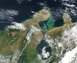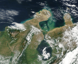
Guajira Peninsula
Encyclopedia

Colony
In politics and history, a colony is a territory under the immediate political control of a state. For colonies in antiquity, city-states would often found their own colonies. Some colonies were historically countries, while others were territories without definite statehood from their inception....
period texts), is a peninsula
Peninsula
A peninsula is a piece of land that is bordered by water on three sides but connected to mainland. In many Germanic and Celtic languages and also in Baltic, Slavic and Hungarian, peninsulas are called "half-islands"....
in northern Colombia
Colombia
Colombia, officially the Republic of Colombia , is a unitary constitutional republic comprising thirty-two departments. The country is located in northwestern South America, bordered to the east by Venezuela and Brazil; to the south by Ecuador and Peru; to the north by the Caribbean Sea; to the...
and northwestern Venezuela
Venezuela
Venezuela , officially called the Bolivarian Republic of Venezuela , is a tropical country on the northern coast of South America. It borders Colombia to the west, Guyana to the east, and Brazil to the south...
in the Caribbean Sea
Caribbean Sea
The Caribbean Sea is a sea of the Atlantic Ocean located in the tropics of the Western hemisphere. It is bounded by Mexico and Central America to the west and southwest, to the north by the Greater Antilles, and to the east by the Lesser Antilles....
. It is the northernmost peninsula in South America
South America
South America is a continent situated in the Western Hemisphere, mostly in the Southern Hemisphere, with a relatively small portion in the Northern Hemisphere. The continent is also considered a subcontinent of the Americas. It is bordered on the west by the Pacific Ocean and on the north and east...
and has an area of 25000 km² (9,652.6 sq mi) extending from the Manaure
Manaure
Manaure was the name of an indigenous chief or Cacique in Maracaibo it may also refer to:*Manaure, Cesar a town and municipality in Colombia*Manaure, La Guajira a town and municipality in Colombia...
Bay (Colombia) to the Calabozo
Calabozo
Villa de Todos los Santos de Calabozo, an inland town of Venezuela, once capital of the Province of Caracas in the colonial period, formerly in the State of Miranda and former capital of the state of Guárico....
Ensenada in the Gulf of Venezuela
Gulf of Venezuela
The Gulf of Venezuela is a gulf of the Caribbean Sea bounded by the Venezuelan states of Zulia and Falcón and by Guajira Department, Colombia...
(Venezuela), and from the Caribbean Sea
Caribbean Sea
The Caribbean Sea is a sea of the Atlantic Ocean located in the tropics of the Western hemisphere. It is bounded by Mexico and Central America to the west and southwest, to the north by the Greater Antilles, and to the east by the Lesser Antilles....
to the Serrania del Perija
Serrania del Perija
The Serranía del Perijá, Cordillera de Perijá or Sierra de Perijá is a mountain range, an extension of the eastern Andean branch , in northern South America, between Colombia and Venezuela, ending further north in the Guajira Desert, a total distance of about 310 km...
mountains range. It was the subject of a dispute between Venezuela
Venezuela
Venezuela , officially called the Bolivarian Republic of Venezuela , is a tropical country on the northern coast of South America. It borders Colombia to the west, Guyana to the east, and Brazil to the south...
and Colombia
Colombia
Colombia, officially the Republic of Colombia , is a unitary constitutional republic comprising thirty-two departments. The country is located in northwestern South America, bordered to the east by Venezuela and Brazil; to the south by Ecuador and Peru; to the north by the Caribbean Sea; to the...
in 1891, and on arbitration was awarded to the latter and joined to its Magdalena Department
Magdalena Department
Magdalena is a department of Colombia, located to the north of the country by the Caribbean Sea. The capital of the Magdalena Department is Santa Marta and was named after the Magdalena River...
. Nowadays, most of the territory is part of Colombia, making part of La Guajira Department, while the remaining strip pertains to the Venezuelan Zulia State. The northern most part of the peninsula is called Punta Gallinas
Punta Gallinas
Punta Gallinas is a headland in northern Colombia and the Northernmost point on the mainland of South America and one of the Extreme points of South America...
(12° 28´ N) and is also considered the northernmost part of mainland South America.
Climate
The scenery of Guajira is very picturesque; the temperature in the plains is very high, but temperate in the mountains.The region receives the flow of the trade wind
Trade wind
The trade winds are the prevailing pattern of easterly surface winds found in the tropics, within the lower portion of the Earth's atmosphere, in the lower section of the troposphere near the Earth's equator...
s from the northern hemisphere and forms along the northeastern coast of Venezuela and the Antilles
Antilles
The Antilles islands form the greater part of the West Indies in the Caribbean Sea. The Antilles are divided into two major groups: the "Greater Antilles" to the north and west, including the larger islands of Cuba, Jamaica, Hispaniola , and Puerto Rico; and the smaller "Lesser Antilles" on the...
, the Guajira-Barranquilla xeric scrub
Guajira-Barranquilla xeric scrub
The Guajira-Barranquilla xeric scrub is a xeric shrubland ecoregion in Colombia, covering an estimated area of 150.000 km2.-Setting:The ecoregion occupies the Guajira Peninsula, the valley of Rancheria river and Guajira Department, covering parts of the northeastern coast of Venezuela...
. The Trade winds cause a resurgence of the deep littoral waters and makes the sea more rich in living species on the western side of the peninsula. The northeastern flank of the Sierra Nevada de Santa Marta
Sierra Nevada de Santa Marta
The Sierra Nevada de Santa Marta is an isolated mountain range apart from the Andes chain that runs through Colombia. Reaching an altitude of 5,700 metres above sea level just 42 km from the Caribbean coast, the Sierra Nevada is the world's highest coastal range...
mountain range acts as a barrier that generates abundant rainfall in its steps and originate the Rancheria River
Rancheria River
Rancheria River may refer to the:*the Ranchería River, a river in the department of La Guajira in Colombia*the Rancheria River , a river in the Yukon Territory, Canada, tributary to the Liard River....
, the only major river in the area. Climate and vegetation varies from south to north, presenting a hyper humid jungle weather in the southern part (3000 mm a year) to the desertic areas in the north (300 mm a year).
In the northern area there is a small range of mountains called Macuira
Serranía de Macuira
Serranía de Macuira is a mountain range in northern Colombia located in the municipality of Uribia, Guajira Peninsula and part of the La Guajira Department. The Serrania de Macuira stands in the middle of the La Guajira Desert at 864 meters over sea level, isolated from the mountain ranges of...
that reaches 900 m over sea level that trap some of the Trade winds and cause mist
Mist
Mist is a phenomenon of small droplets suspended in air. It can occur as part of natural weather or volcanic activity, and is common in cold air above warmer water, in exhaled air in the cold, and in a steam room of a sauna. It can also be created artificially with aerosol canisters if the...
. Most of the mountain range is a protected area
Protected area
Protected areas are locations which receive protection because of their recognised natural, ecological and/or cultural values. There are several kinds of protected areas, which vary by level of protection depending on the enabling laws of each country or the regulations of the international...
called National Natural Park of Macuira. Nearby there is also the 80 km² Flamingos Fauna and Flora Sanctuary
Flamingos Fauna and Flora Sanctuary
Flamingos Fauna and Flora Sanctuary has been a natural park since 1977. It is located in the Colombian Caribbean Region and the Guajira Peninsula and part of the department of La Guajira....
.
Economy
The peninsula is mainly inhabited by members of the native tribeIndigenous peoples in Colombia
The indigenous peoples in Colombia comprise a large number of distinct ethnic groups who inhabited the country's present territory prior to its discovery by Europeans around 1500.-Origins:...
of the Wayuu
Wayuu
Wayuu is an Amerindian ethnic group of the La Guajira Peninsula in northern Colombia and northwest Venezuela. They are part of the Maipurean language family.- Geography :...
s which use the plains to raise cattle, sheeps, goats and horses. The descendants of the Spanish
Spanish people
The Spanish are citizens of the Kingdom of Spain. Within Spain, there are also a number of vigorous nationalisms and regionalisms, reflecting the country's complex history....
colonizers settled in the southeastern part of the peninsula (sometimes referred to as the Padilla Province) were the land is more fertile due to the proximity to other river basins, such as the cesar river basin
Cesar River
The Cesar River is a river in northern Colombia which is a part of the Magdalena Basin. It separates the Sierra Nevada de Santa Marta from the mountain ranges of the Serrania del Perija an extension of the Cordillera Oriental...
and is subject to large plantations of cotton, sorghum and cattle ranching.
Since the 1980s the central area of the peninsula was subject to the exploration and exploitation of coal
Coal
Coal is a combustible black or brownish-black sedimentary rock usually occurring in rock strata in layers or veins called coal beds or coal seams. The harder forms, such as anthracite coal, can be regarded as metamorphic rock because of later exposure to elevated temperature and pressure...
and natural gas
Natural gas
Natural gas is a naturally occurring gas mixture consisting primarily of methane, typically with 0–20% higher hydrocarbons . It is found associated with other hydrocarbon fuel, in coal beds, as methane clathrates, and is an important fuel source and a major feedstock for fertilizers.Most natural...
in the area of Cerrejon
Cerrejón
Cerrejón is a coal mine located in the Guajira department in the north of Colombia. It is the largest mining operation in Colombia and among the largest open-pit coal mines in the world. The legal entity managing the Cerrejón operation is known as Carbones del Cerrejón Ltd...
and of oil
Petroleum
Petroleum or crude oil is a naturally occurring, flammable liquid consisting of a complex mixture of hydrocarbons of various molecular weights and other liquid organic compounds, that are found in geologic formations beneath the Earth's surface. Petroleum is recovered mostly through oil drilling...
in the littoral. A popular ecotourism
Ecotourism
Ecotourism is a form of tourism visiting fragile, pristine, and usually protected areas, intended as a low impact and often small scale alternative to standard commercial tourism...
destination in the area is Cabo de la Vela
Cabo de la Vela
Cabo de la Vela is a headland in the Guajira Peninsula in Colombia with an adjacent small fishing village. It is a popular ecotourism destination of the Caribbean Region of Colombia-History:...
Missionary history

Pope Pius X
Pope Saint Pius X , born Giuseppe Melchiorre Sarto, was the 257th Pope of the Catholic Church, serving from 1903 to 1914. He was the first pope since Pope Pius V to be canonized. Pius X rejected modernist interpretations of Catholic doctrine, promoting traditional devotional practices and orthodox...
on 17 January 1905, into a vicariate Apostolic, dependent on the Congregation for Extraordinary Ecclesiastical Affairs
Congregation for Extraordinary Ecclesiastical Affairs
The Sacred Congregation for Extraordinary Ecclesiastical Affairs was a congregation of the Roman Curia, erected by Pope Pius VII on 19 July 1814 by extending the competence to the Sacred Congregation for the Ecclesiastical Affairs of the Kingdom of France , which Pope Pius VI had set up in 1793...
. Mgr
Monsignor
Monsignor, pl. monsignori, is the form of address for those members of the clergy of the Catholic Church holding certain ecclesiastical honorific titles. Monsignor is the apocopic form of the Italian monsignore, from the French mon seigneur, meaning "my lord"...
Attanasio Maria Vincenzo Soler-Royo, O.F.M. Cap., was appointed to the vicariate, as titular Bishop of Citharizum, on 18 April 1907. The early 20th century missionaries described the inhabitants of the area as "tall and well made. Formerly they were very intractable, but the Capuchins
Order of Friars Minor Capuchin
The Order of Friars Minor Capuchin is an Order of friars in the Catholic Church, among the chief offshoots of the Franciscans. The worldwide head of the Order, called the Minister General, is currently Father Mauro Jöhri.-Origins :...
, who were in charge of the Catholic missions, have had a great influence over them, and large numbers have been converted. The chief towns are Paraguaipoa, Calabacito, Maricha
Maricha
Maricha or Mareecha was a rakshasa who played a small but important part in the Indian Ramayana epic. He was thrown into a remote island by the arrow of Lord Rama when he tried to interrupt Sage Vishwamitra's yagna. After that he became very afraid of the very mention of the name Rama...
, Marocaso and Soldado." Today, the Catholic education is no longer mandatory for the indigenous people, who are allowed to educate their children in the Wayuu traditions and language (Wayuunaiki
Wayuu language
The Wayuu language, or Goajiro , is spoken by 305,000 indigenous Wayuu people in northeastern Colombia and northwestern Venezuela on the Guajira Peninsula....
).
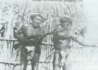
In Papillon, Henri Charrière writes: "The Goajira Indians are seafarers who fish for pearl
Pearl
A pearl is a hard object produced within the soft tissue of a living shelled mollusk. Just like the shell of a mollusk, a pearl is made up of calcium carbonate in minute crystalline form, which has been deposited in concentric layers. The ideal pearl is perfectly round and smooth, but many other...
s. Their primary diet is said to consist of fish, turtle
Turtle
Turtles are reptiles of the order Testudines , characterised by a special bony or cartilaginous shell developed from their ribs that acts as a shield...
meat, turtle eggs and big green lizards, most likely Iguana
Iguana
Iguana is a herbivorous genus of lizard native to tropical areas of Central America and the Caribbean. The genus was first described in 1768 by Austrian naturalist Josephus Nicolaus Laurenti in his book Specimen Medicum, Exhibens Synopsin Reptilium Emendatam cum Experimentis circa Venena...
s. Men and women are dressed only in a loincloth
Loincloth
A loincloth is a one-piece male garment, sometimes kept in place by a belt, which covers the genitals and, at least partially, the buttocks.-History and types:Loincloths are being and have been worn:*in societies where no other clothing is needed or wanted...
which covers their crotch."
See also
- Distocyclus goajira, an Electric fish
- T-63 Goajira, a ship the of the Navy of Venezuela
- Guajira Department, Guajira-Barranquilla xeric scrubGuajira-Barranquilla xeric scrubThe Guajira-Barranquilla xeric scrub is a xeric shrubland ecoregion in Colombia, covering an estimated area of 150.000 km2.-Setting:The ecoregion occupies the Guajira Peninsula, the valley of Rancheria river and Guajira Department, covering parts of the northeastern coast of Venezuela...
and La Guajira DesertLa Guajira DesertLa Guajira Desert is located in the northernmost part of Colombia, north of Bogota, in the La Guajira Department, covering most of La Guajira Peninsula including Venezuelan territory. The area holds immense coal reserves, exploited in a zone known as El Cerrejon...
Books
Henri Candelier. 1892. Riohacha y los Indios Guajiros. Crónica de un viajero y explorador francés quien durante tres años, 1889–1892, recorrió La Guajira.Martha Ligia Castellanos, Luis Carlos Pardo L. 2000. Caracterización y primera aproximación a la determinación del índice de biodiversidad en los suelos de la cuenca del arroyo Mekijanao, Serranía de la Macuira, Alta Guajira. En: Juan Carlos Pérez (editor) X Congreso Nacional de la Ciencia del Suelo. Programa y resúmenes. El suelo un componente del medio natural. Medellín, Octubre 11 al 13 de 2000
Edith González, Gabriel Guillot, Néstor Miranda, Diana Pombo (editores). 1990. Perfil Ambiental de Colombia. Colciencias. Escala. Bogotá.
Instituto Geográfico Agustín Codazzi. 1996. Diccionario Geográfico de Colombia. Edición en CD-ROM. Bogotá, Colombia.
- Thomas Stadtmüller. 1987. Cloud Forests in the Humid Tropics. A Bibliographic Review. The United Nations University, Centro Agronómico Tropical de Investigación y Enseñanza. Turrialba, Costa Rica. 82 pp.

