

Prevailing winds
Encyclopedia
Earth
Earth is the third planet from the Sun, and the densest and fifth-largest of the eight planets in the Solar System. It is also the largest of the Solar System's four terrestrial planets...
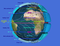
's surface. The dominant winds are the trends in direction of wind with the highest speed over a particular point on the Earth's surface. A region's prevailing and dominant winds are often affected by global patterns of movement in the Earth's atmosphere
Earth's atmosphere
The atmosphere of Earth is a layer of gases surrounding the planet Earth that is retained by Earth's gravity. The atmosphere protects life on Earth by absorbing ultraviolet solar radiation, warming the surface through heat retention , and reducing temperature extremes between day and night...
. In general, easterly flow exists at low and high latitudes globally. In the mid-latitudes, westerly winds are the rule and their strength is at the mercy of the polar cyclone
Polar cyclone
Polar cyclones are low-pressure areas which strengthen in the winter and weaken in the summer...
. In areas where winds tend to be light, the sea breeze
Sea breeze
A sea-breeze is a wind from the sea that develops over land near coasts. It is formed by increasing temperature differences between the land and water; these create a pressure minimum over the land due to its relative warmth, and forces higher pressure, cooler air from the sea to move inland...
/land breeze cycle is the most important to the prevailing wind; in areas which have variable terrain, mountain and valley breezes dominate the wind pattern. Highly elevated surfaces can induce a thermal low
Thermal low
Thermal lows, or heat lows, are non-frontal low-pressure areas that occur over the continents in the subtropics such as near the Sonoran Desert, the Mexican plateau, Sahara, South America over northwest Argentina, Australia, the Iberian peninsula, and Tibetan plateau during the warm season as the...
, which then augments the environmental wind flow.
Wind rose
Wind rose
A wind rose is a graphic tool used by meteorologists to give a succinct view of how wind speed and direction are typically distributed at a particular location. Historically, wind roses were predecessors of the compass rose , as there was no differentiation between a cardinal direction and the wind...
s are tools used to determine the direction of the prevailing wind. Knowledge of the prevailing wind allows the development of prevention strategies for soil erosion of agricultural land, such as across the Great Plains
Great Plains
The Great Plains are a broad expanse of flat land, much of it covered in prairie, steppe and grassland, which lies west of the Mississippi River and east of the Rocky Mountains in the United States and Canada. This area covers parts of the U.S...
. Sand dunes can orient themselves along, or perpendicular, to the prevailing wind regime within coastal and desert locations. Insect
Insect
Insects are a class of living creatures within the arthropods that have a chitinous exoskeleton, a three-part body , three pairs of jointed legs, compound eyes, and two antennae...
s drift along with the prevailing wind, while birds are able to fly more independently of the prevailing wind. Prevailing winds in mountainous locations can lead to significant rainfall
Precipitation (meteorology)
In meteorology, precipitation In meteorology, precipitation In meteorology, precipitation (also known as one of the classes of hydrometeors, which are atmospheric water phenomena is any product of the condensation of atmospheric water vapor that falls under gravity. The main forms of precipitation...
gradients within the topography, ranging from wet across windward-facing slopes to desert
Desert
A desert is a landscape or region that receives an extremely low amount of precipitation, less than enough to support growth of most plants. Most deserts have an average annual precipitation of less than...
-like conditions along their lee slopes.
Determination for a location
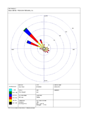
A wind rose
Wind rose
A wind rose is a graphic tool used by meteorologists to give a succinct view of how wind speed and direction are typically distributed at a particular location. Historically, wind roses were predecessors of the compass rose , as there was no differentiation between a cardinal direction and the wind...
is a graphic tool used by meteorologists to give a succinct view of how wind speed
Wind speed
Wind speed, or wind velocity, is a fundamental atmospheric rate.Wind speed affects weather forecasting, aircraft and maritime operations, construction projects, growth and metabolism rate of many plant species, and countless other implications....
and direction are typically distributed at a particular location. Presented in a polar coordinate
Polar coordinate system
In mathematics, the polar coordinate system is a two-dimensional coordinate system in which each point on a plane is determined by a distance from a fixed point and an angle from a fixed direction....
grid, the wind rose shows the frequency of winds blowing from particular directions. The length of each spoke around the circle is related to the frequency that the wind blows from a particular direction per unit time. Each concentric circle represents a different frequency, emanating from zero at the center to increasing frequencies at the outer circles. A wind rose plot may contain additional information, in that each spoke is broken down into color-coded bands that show wind speed ranges. Wind roses typically use 8 or 16 cardinal direction
Cardinal direction
The four cardinal directions or cardinal points are the directions of north, east, south, and west, commonly denoted by their initials: N, E, S, W. East and west are at right angles to north and south, with east being in the direction of rotation and west being directly opposite. Intermediate...
s, such as north (N), NNE, NE, etc., although they may be subdivided into as many as 32 directions
Boxing the compass
Boxing the compass is the action of naming all thirty-two points of the compass in clockwise order. Such names are formed by the initials of the cardinal directions and their intermediate ordinal directions, and are very handy to refer to a heading in a general or colloquial fashion, without...
.
Trades and their impact
The trade winds (also called trades) are the prevailing pattern of easterlyEasterlies
The easterlies commonly refer to the low latitude trade winds near the equator . These winds carry tropical waves and cyclones from east to west in lower latitudes...
surface wind
Wind
Wind is the flow of gases on a large scale. On Earth, wind consists of the bulk movement of air. In outer space, solar wind is the movement of gases or charged particles from the sun through space, while planetary wind is the outgassing of light chemical elements from a planet's atmosphere into space...
s found in the tropics
Tropics
The tropics is a region of the Earth surrounding the Equator. It is limited in latitude by the Tropic of Cancer in the northern hemisphere at approximately N and the Tropic of Capricorn in the southern hemisphere at S; these latitudes correspond to the axial tilt of the Earth...
near the Earth's equator
Equator
An equator is the intersection of a sphere's surface with the plane perpendicular to the sphere's axis of rotation and containing the sphere's center of mass....
, equatorward of the subtropical ridge
Subtropical ridge
The subtropical ridge is a significant belt of high pressure situated around the latitudes of 30°N in the Northern Hemisphere and 30°S in the Southern Hemisphere. It is characterized by mostly calm winds, which acts to reduce air quality under its axis by causing fog overnight, and haze during...
. These winds blow predominantly from the northeast in the Northern Hemisphere
Northern Hemisphere
The Northern Hemisphere is the half of a planet that is north of its equator—the word hemisphere literally means “half sphere”. It is also that half of the celestial sphere north of the celestial equator...
and from the southeast in the Southern Hemisphere
Southern Hemisphere
The Southern Hemisphere is the part of Earth that lies south of the equator. The word hemisphere literally means 'half ball' or "half sphere"...
. The trade winds act as the steering flow for tropical cyclones that form over world's oceans, guiding their path westward. Trade winds also steer African dust westward across the Atlantic ocean
Atlantic Ocean
The Atlantic Ocean is the second-largest of the world's oceanic divisions. With a total area of about , it covers approximately 20% of the Earth's surface and about 26% of its water surface area...
into the Caribbean sea
Caribbean Sea
The Caribbean Sea is a sea of the Atlantic Ocean located in the tropics of the Western hemisphere. It is bounded by Mexico and Central America to the west and southwest, to the north by the Greater Antilles, and to the east by the Lesser Antilles....
, as well as portions of southeast North America
North America
North America is a continent wholly within the Northern Hemisphere and almost wholly within the Western Hemisphere. It is also considered a northern subcontinent of the Americas...
.
Westerlies and their impact
The westerlies
Westerlies
The Westerlies, anti-trades, or Prevailing Westerlies, are the prevailing winds in the middle latitudes between 30 and 60 degrees latitude, blowing from the high pressure area in the horse latitudes towards the poles. These prevailing winds blow from the west to the east, and steer extratropical...
or the prevailing westerlies are the prevailing winds in the middle latitudes
Middle latitudes
The middle latitudes are between 23°26'22" North and 66°33'39" North, and between 23°26'22" South and 66°33'39" South latitude, or, the Earth's temperate zones between the tropics and the Arctic and Antarctic. The prevailing winds in the middle latitudes are often very strong...
between 35 and 65 degrees latitude
Latitude
In geography, the latitude of a location on the Earth is the angular distance of that location south or north of the Equator. The latitude is an angle, and is usually measured in degrees . The equator has a latitude of 0°, the North pole has a latitude of 90° north , and the South pole has a...
which blow from west to east poleward of the high pressure area
High pressure area
A high-pressure area is a region where the atmospheric pressure at the surface of the planet is greater than its surrounding environment. Winds within high-pressure areas flow outward due to the higher density air near their center and friction with land...
known as the subtropical ridge in the horse latitudes
Horse latitudes
Horse Latitudes or Subtropical High are subtropical latitudes between 30 and 35 degrees both north and south. This region, under a ridge of high pressure called the subtropical high, is an area which receives little precipitation and has variable winds mixed with calm.The consistently warm, dry...
. These prevailing winds blow from the west
West
West is a noun, adjective, or adverb indicating direction or geography.West is one of the four cardinal directions or compass points. It is the opposite of east and is perpendicular to north and south.By convention, the left side of a map is west....
to the east
East
East is a noun, adjective, or adverb indicating direction or geography.East is one of the four cardinal directions or compass points. It is the opposite of west and is perpendicular to north and south.By convention, the right side of a map is east....
, and steer extratropical cyclones in this general manner. The winds are predominantly from the southwest in the Northern Hemisphere and from the northwest in the Southern Hemisphere. They are strongest in the winter when the pressure is lower over the poles, such as when the polar cyclone is strongest, and weakest during the summer when the polar cyclone is weakest and when pressures are higher over the poles.
Together with the trade wind
Trade wind
The trade winds are the prevailing pattern of easterly surface winds found in the tropics, within the lower portion of the Earth's atmosphere, in the lower section of the troposphere near the Earth's equator...
s, the westerlies enabled a round-trip trade route for sailing ships crossing the Atlantic and Pacific oceans, as the westerlies lead to the development of strong ocean currents in both hemispheres. The westerlies can be particularly strong, especially in the southern hemisphere, where there is less land in the middle latitudes to cause the flow pattern to amplify, which slows the winds down. The strongest westerly winds in the middle latitudes are called the Roaring Forties
Roaring Forties
The Roaring Forties is the name given to strong westerly winds found in the Southern Hemisphere, generally between the latitudes of 40 and 49 degrees. Air displaced from the Equator towards the South Pole, which travels close to the surface between the latitudes of 30 and 60 degrees south, combines...
, between 40 and 50 degrees south latitude, within the Southern Hemisphere. The westerlies play an important role in carrying the warm, equatorial waters and winds to the western coasts of continents, especially in the southern hemisphere because of its vast oceanic expanse.
Polar easterlies
The polar easterliesPolar easterlies
The polar easterlies are the dry, cold prevailing winds that blow from the high-pressure areas of the polar highs at the north and south poles towards low-pressure areas within the Westerlies at high latitudes...
(also known as Polar Hadley cells) are the dry, cold prevailing winds that blow from the high-pressure areas of the polar high
Polar high
The polar highs are areas of high atmospheric pressure around the north and south poles, south polar high being the stronger one because land gains and loses heat more effectively than sea...
s at the north
North Pole
The North Pole, also known as the Geographic North Pole or Terrestrial North Pole, is, subject to the caveats explained below, defined as the point in the northern hemisphere where the Earth's axis of rotation meets its surface...
and South pole
South Pole
The South Pole, also known as the Geographic South Pole or Terrestrial South Pole, is one of the two points where the Earth's axis of rotation intersects its surface. It is the southernmost point on the surface of the Earth and lies on the opposite side of the Earth from the North Pole...
s towards the low-pressure areas within the westerlies at high latitudes. Like trade winds and unlike the westerlies, these prevailing winds blow from the east
East
East is a noun, adjective, or adverb indicating direction or geography.East is one of the four cardinal directions or compass points. It is the opposite of west and is perpendicular to north and south.By convention, the right side of a map is east....
to the west
West
West is a noun, adjective, or adverb indicating direction or geography.West is one of the four cardinal directions or compass points. It is the opposite of east and is perpendicular to north and south.By convention, the left side of a map is west....
, and are often weak and irregular. Due to the low sun
Sun
The Sun is the star at the center of the Solar System. It is almost perfectly spherical and consists of hot plasma interwoven with magnetic fields...
angle, cold
Cold
Cold describes the condition of low temperature.Cold may also refer to:*Common cold, a contagious viral infectious disease of the upper respiratory system*Chronic obstructive pulmonary disease...
air builds up and subsides at the pole creating surface high-pressure areas, forcing an equator
Equator
An equator is the intersection of a sphere's surface with the plane perpendicular to the sphere's axis of rotation and containing the sphere's center of mass....
ward outflow of air; that outflow is deflected westward by the Coriolis effect
Coriolis effect
In physics, the Coriolis effect is a deflection of moving objects when they are viewed in a rotating reference frame. In a reference frame with clockwise rotation, the deflection is to the left of the motion of the object; in one with counter-clockwise rotation, the deflection is to the right...
.
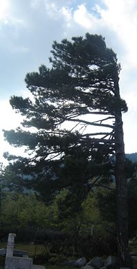
Sea and land breezes
In areas where the wind flow is light, sea breezes and land breezes are important factors in a location's prevailing winds. The seaOcean
An ocean is a major body of saline water, and a principal component of the hydrosphere. Approximately 71% of the Earth's surface is covered by ocean, a continuous body of water that is customarily divided into several principal oceans and smaller seas.More than half of this area is over 3,000...
is warmed by the sun to a greater depth than the land due to its greater specific heat. The sea therefore has a greater capacity for absorbing heat than the land, so the surface of the sea warms up more slowly than the land's surface. As the temperature of the surface of the land
Landform
A landform or physical feature in the earth sciences and geology sub-fields, comprises a geomorphological unit, and is largely defined by its surface form and location in the landscape, as part of the terrain, and as such, is typically an element of topography...
rises, the land heats the air above it. The warm air is less dense and so it rises. This rising air over the land lowers the sea level pressure by about 0.2%. The cooler air above the sea, now with higher sea level pressure, flows towards the land into the lower pressure, creating a cooler breeze near the coast.
The strength of the sea breeze is directly proportional to the temperature difference between the land mass and the sea. If an offshore wind of 8 knots (15.7 km/h) exists, the sea breeze is not likely to develop. At night, the land cools off more quickly than the ocean due to differences in their specific heat values, which forces the daytime sea breeze to dissipate. If the temperature onshore cools below the temperature offshore, the pressure over the water will be lower than that of the land, establishing a land breeze, as long as an onshore wind is not strong enough to oppose it.
Circulation in elevated regions
Sea level
Mean sea level is a measure of the average height of the ocean's surface ; used as a standard in reckoning land elevation...
, creating an associated thermal low
Thermal low
Thermal lows, or heat lows, are non-frontal low-pressure areas that occur over the continents in the subtropics such as near the Sonoran Desert, the Mexican plateau, Sahara, South America over northwest Argentina, Australia, the Iberian peninsula, and Tibetan plateau during the warm season as the...
over the terrain and enhancing any lows which would have otherwise existed, and changing the wind circulation of the region. In areas where there is rugged topography
Topography
Topography is the study of Earth's surface shape and features or those ofplanets, moons, and asteroids...
that significantly interrupts the environmental wind flow, the wind can change direction and accelerate parallel to the wind obstruction. This barrier jet can increase the low level wind by 45 percent. In mountainous areas, local distortion of the airflow is more severe. Jagged terrain combines to produce unpredictable flow patterns and turbulence, such as rotor
Lee waves
In meteorology, lee waves are atmospheric standing waves. The most common form is mountain waves, which are atmospheric internal gravity waves...
s. Strong updrafts, downdrafts and eddies develop as the air flows over hills and down valleys. Wind direction changes due to the contour of the land. If there is a pass
Mountain pass
A mountain pass is a route through a mountain range or over a ridge. If following the lowest possible route, a pass is locally the highest point on that route...
in the mountain range, winds will rush through the pass with considerable speed due to the Bernoulli principle that describes an inverse relationship between speed and pressure. The airflow can remain turbulent and erratic for some distance downwind into the flatter countryside. These conditions are dangerous to ascending and descending airplanes.
Daytime heating and nighttime cooling of the hilly slopes lead to day to night variations in the airflow, similar to the relationship between sea breeze and land breeze. At night, the sides of the hills cool through radiation of the heat. The air along the hills becomes cooler and denser, blowing down into the valley, drawn by gravity. This is known a katabatic wind
Katabatic wind
A katabatic wind, from the Greek word katabatikos meaning "going downhill", is the technical name for a drainage wind, a wind that carries high density air from a higher elevation down a slope under the force of gravity. Such winds are sometimes also called fall winds...
or mountain breeze. If the slopes are covered with ice and snow, the katabatic wind will blow during the day, carrying the cold dense air into the warmer, barren valleys. The slopes of hills not covered by snow will be warmed during the day. The air that comes in contact with the warmed slopes becomes warmer and less dense and flows uphill. This is known as an anabatic wind or valley breeze.
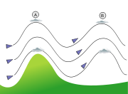
Effect on precipitation

Orographic precipitation occurs on the windward side of mountains and is caused by the rising air motion of a large-scale flow of moist air across the mountain ridge, resulting in adiabatic cooling and condensation
Condensation
Condensation is the change of the physical state of matter from gaseous phase into liquid phase, and is the reverse of vaporization. When the transition happens from the gaseous phase into the solid phase directly, the change is called deposition....
. In mountainous parts of the world subjected to consistent winds (for example, the trade wind
Trade wind
The trade winds are the prevailing pattern of easterly surface winds found in the tropics, within the lower portion of the Earth's atmosphere, in the lower section of the troposphere near the Earth's equator...
s), a more moist climate
Climate
Climate encompasses the statistics of temperature, humidity, atmospheric pressure, wind, rainfall, atmospheric particle count and other meteorological elemental measurements in a given region over long periods...
usually prevails on the windward side of a mountain than on the leeward or downwind side. Moisture is removed by orographic lift, leaving drier air (see katabatic wind
Katabatic wind
A katabatic wind, from the Greek word katabatikos meaning "going downhill", is the technical name for a drainage wind, a wind that carries high density air from a higher elevation down a slope under the force of gravity. Such winds are sometimes also called fall winds...
) on the descending and generally warming, leeward side where a rain shadow
Rain shadow
A rain shadow is a dry area on the lee side of a mountainous area. The mountains block the passage of rain-producing weather systems, casting a "shadow" of dryness behind them. As shown by the diagram to the right, the warm moist air is "pulled" by the prevailing winds over a mountain...
is observed.
In South America, the Andes
Andes
The Andes is the world's longest continental mountain range. It is a continual range of highlands along the western coast of South America. This range is about long, about to wide , and of an average height of about .Along its length, the Andes is split into several ranges, which are separated...
mountain range blocks Pacific
Pacific Ocean
The Pacific Ocean is the largest of the Earth's oceanic divisions. It extends from the Arctic in the north to the Southern Ocean in the south, bounded by Asia and Australia in the west, and the Americas in the east.At 165.2 million square kilometres in area, this largest division of the World...
moisture that arrives in that continent, resulting in a desertlike climate just downwind across western Argentina. The Sierra Nevada range creates the same effect in North America forming the Great Basin
Great Basin
The Great Basin is the largest area of contiguous endorheic watersheds in North America and is noted for its arid conditions and Basin and Range topography that varies from the North American low point at Badwater Basin to the highest point of the contiguous United States, less than away at the...
and Mojave Desert
Mojave Desert
The Mojave Desert occupies a significant portion of southeastern California and smaller parts of central California, southern Nevada, southwestern Utah and northwestern Arizona, in the United States...
s.
Effect on nature
Insect
Insect
Insects are a class of living creatures within the arthropods that have a chitinous exoskeleton, a three-part body , three pairs of jointed legs, compound eyes, and two antennae...
s, also known as arthropod
Arthropod
An arthropod is an invertebrate animal having an exoskeleton , a segmented body, and jointed appendages. Arthropods are members of the phylum Arthropoda , and include the insects, arachnids, crustaceans, and others...
s, are swept along by the prevailing winds, while birds follow their own course. As such, fine line patterns within weather radar
Weather radar
Weather radar, also called weather surveillance radar and Doppler weather radar, is a type of radar used to locate precipitation, calculate its motion, estimate its type . Modern weather radars are mostly pulse-Doppler radars, capable of detecting the motion of rain droplets in addition to the...
imagery, associated with converging winds, are dominated by insect returns. In the Great Plains
Great Plains
The Great Plains are a broad expanse of flat land, much of it covered in prairie, steppe and grassland, which lies west of the Mississippi River and east of the Rocky Mountains in the United States and Canada. This area covers parts of the U.S...
, soil erosion
Erosion
Erosion is when materials are removed from the surface and changed into something else. It only works by hydraulic actions and transport of solids in the natural environment, and leads to the deposition of these materials elsewhere...
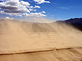
of agricultural land is a significant problem, and is mainly driven by the prevailing wind. Because of this, wind barrier strips have been developed to minimize this type of erosion. The strips can be in the form of soil ridges, crop strips, crops rows, or trees which act as wind breaks. They are oriented at a right angle to the wind in order to be most effective. In regions with minimal vegetation, such as coastal and desert
Desert
A desert is a landscape or region that receives an extremely low amount of precipitation, less than enough to support growth of most plants. Most deserts have an average annual precipitation of less than...
areas, transverse sand dunes orient themselves perpendicular to the prevailing wind direction, while longitudinal dunes orient themselves parallel to the prevailing winds.