
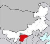
Ordos Desert
Encyclopedia
Desert
A desert is a landscape or region that receives an extremely low amount of precipitation, less than enough to support growth of most plants. Most deserts have an average annual precipitation of less than...
and steppe
Steppe
In physical geography, steppe is an ecoregion, in the montane grasslands and shrublands and temperate grasslands, savannas, and shrublands biomes, characterized by grassland plains without trees apart from those near rivers and lakes...
region lying on a plateau
Plateau
In geology and earth science, a plateau , also called a high plain or tableland, is an area of highland, usually consisting of relatively flat terrain. A highly eroded plateau is called a dissected plateau...
in the south of the Inner Mongolian Autonomous Region of the People's Republic of China
People's Republic of China
China , officially the People's Republic of China , is the most populous country in the world, with over 1.3 billion citizens. Located in East Asia, the country covers approximately 9.6 million square kilometres...
(centered ca. 39°N 109°E). The soil
Soil
Soil is a natural body consisting of layers of mineral constituents of variable thicknesses, which differ from the parent materials in their morphological, physical, chemical, and mineralogical characteristics...
of the Ordos is a mixture of clay
Clay
Clay is a general term including many combinations of one or more clay minerals with traces of metal oxides and organic matter. Geologic clay deposits are mostly composed of phyllosilicate minerals containing variable amounts of water trapped in the mineral structure.- Formation :Clay minerals...
and sand
Sand
Sand is a naturally occurring granular material composed of finely divided rock and mineral particles.The composition of sand is highly variable, depending on the local rock sources and conditions, but the most common constituent of sand in inland continental settings and non-tropical coastal...
and, as a result, is poorly suited for agriculture
Agriculture
Agriculture is the cultivation of animals, plants, fungi and other life forms for food, fiber, and other products used to sustain life. Agriculture was the key implement in the rise of sedentary human civilization, whereby farming of domesticated species created food surpluses that nurtured the...
. It extends over an area of approximately 90,650 km². It comprises two large deserts: the 7th largest desert in China, the Kubuqi Desert (/庫布齊沙漠; pinyin: ) in the north, and the 8th largest desert in China, the Maowusu Desert (/毛烏素沙漠; pinyin: ), in the south. [Some maps do not use these two names but use 'Mu Us (Ordos) Desert'.]
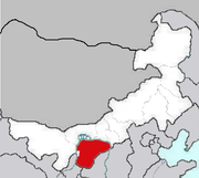
Location
The Ordos Desert is almost completely encircled by the Great Bend of the Yellow RiverYellow River
The Yellow River or Huang He, formerly known as the Hwang Ho, is the second-longest river in China and the sixth-longest in the world at the estimated length of . Originating in the Bayan Har Mountains in Qinghai Province in western China, it flows through nine provinces of China and empties into...
(Ordos Loop
Ordos Loop
The Ordos Loop is a region of China west of Beijing. The Yellow River flows north-northeast, then east, and then south forming three sides of an imperfect rectangle. The south side is formed by the Wei River which rises not far from the southwest corner and flows east to the southeast corner...
) in the west, north, and east. Mountain range
Mountain range
A mountain range is a single, large mass consisting of a succession of mountains or narrowly spaced mountain ridges, with or without peaks, closely related in position, direction, formation, and age; a component part of a mountain system or of a mountain chain...
s separate the Ordos from the Gobi Desert
Gobi Desert
The Gobi is a large desert region in Asia. It covers parts of northern and northwestern China, and of southern Mongolia. The desert basins of the Gobi are bounded by the Altai Mountains and the grasslands and steppes of Mongolia on the north, by the Hexi Corridor and Tibetan Plateau to the...
north and east of the Yellow River. The mountain chains separating the Ordos from the central Gobi in the north of the great bend of the Yellow River are: the Kara-naryn-ula, the Sheitenula, and the Yin Mountains
Yin Mountains
The Yin Mountains are mountains in the steppe forming the southern border of the eastern Gobi Desert of the Inner Mongolia Autonomous Region, as well as the northern part of Hebei province....
, which link on to the south end of the Greater Khingan Mountains
Greater Khingan
The Greater Khingan Range , also called the Greater Hing'an Range or Greater Hinggan Range, is a volcanic mountain range in the northeastern part of the People's Republic of China. The range extends roughly 1,200 km from north to south, narrowing towards the south...
. In the south and east, the Great Wall of China
Great Wall of China
The Great Wall of China is a series of stone and earthen fortifications in northern China, built originally to protect the northern borders of the Chinese Empire against intrusions by various nomadic groups...
separates the Ordos from fertile loess
Loess
Loess is an aeolian sediment formed by the accumulation of wind-blown silt, typically in the 20–50 micrometre size range, twenty percent or less clay and the balance equal parts sand and silt that are loosely cemented by calcium carbonate...
lands. The Ordos covers the southern section of the Inner Mongolia
Inner Mongolia
Inner Mongolia is an autonomous region of the People's Republic of China, located in the northern region of the country. Inner Mongolia shares an international border with the countries of Mongolia and the Russian Federation...
, an Autonomous Region of China, the Ningxia
Ningxia
Ningxia, formerly transliterated as Ningsia, is an autonomous region of the People's Republic of China. Located in Northwest China, on the Loess Plateau, the Yellow River flows through this vast area of land. The Great Wall of China runs along its northeastern boundary...
, an Autonomous Entity of China, and the Chinese Provinces of Shaanxi
Shaanxi
' is a province in the central part of Mainland China, and it includes portions of the Loess Plateau on the middle reaches of the Yellow River in addition to the Qinling Mountains across the southern part of this province...
and Gansu
Gansu
' is a province located in the northwest of the People's Republic of China.It lies between the Tibetan and Huangtu plateaus, and borders Mongolia, Inner Mongolia, and Ningxia to the north, Xinjiang and Qinghai to the west, Sichuan to the south, and Shaanxi to the east...
.
History
Xiongnu
The Xiongnu were ancient nomadic-based people that formed a state or confederation north of the agriculture-based empire of the Han Dynasty. Most of the information on the Xiongnu comes from Chinese sources...
, but was almost depopulated during and after the Dungan revolt of 1869.
This region was a desert during the Late Glacial Maximum. During the Holocene Climatic Optimum
Holocene climatic optimum
The Holocene Climate Optimum was a warm period during roughly the interval 9,000 to 5,000 years B.P.. This event has also been known by many other names, including: Hypsithermal, Altithermal, Climatic Optimum, Holocene Optimum, Holocene Thermal Maximum, and Holocene Megathermal.This warm period...
the monsoon
Monsoon
Monsoon is traditionally defined as a seasonal reversing wind accompanied by corresponding changes in precipitation, but is now used to describe seasonal changes in atmospheric circulation and precipitation associated with the asymmetric heating of land and sea...
al rains that reached the Loess Plateau
Loess Plateau
The Loess Plateau , also known as the Huangtu Plateau, is a plateau that covers an area of some 640,000 km² in the upper and middle reaches of China's Yellow River. Loess is the name for the silty sediment that has been deposited by wind storms on the plateau over the ages...
in the modern era pushed the desert back to the Yellow River. In the modern period, the lack of rainfall has resulted in a return to desert conditions. However, the most disastrous damage to the environment was caused by the political movements launched by Mao Zedong
Mao Zedong
Mao Zedong, also transliterated as Mao Tse-tung , and commonly referred to as Chairman Mao , was a Chinese Communist revolutionary, guerrilla warfare strategist, Marxist political philosopher, and leader of the Chinese Revolution...
, namely the Great Leap Forward
Great Leap Forward
The Great Leap Forward of the People's Republic of China was an economic and social campaign of the Communist Party of China , reflected in planning decisions from 1958 to 1961, which aimed to use China's vast population to rapidly transform the country from an agrarian economy into a modern...
and the Cultural Revolution
Cultural Revolution
The Great Proletarian Cultural Revolution, commonly known as the Cultural Revolution , was a socio-political movement that took place in the People's Republic of China from 1966 through 1976...
, during which the thin line of fragile vegetation separating the Kubuqi and Maowusu deserts was destroyed. Subsequent pressure of population and the increase in sheep/goats/cattle further damaged the already weakened local environment to the point of no return, and as a result, the two deserts finally linked up in the 1990s, forming the larger current day Ordos.
Relief
The Ordos Desert forms an intermediate step in the descent from the HimalayasHimalayas
The Himalaya Range or Himalaya Mountains Sanskrit: Devanagari: हिमालय, literally "abode of snow"), usually called the Himalayas or Himalaya for short, is a mountain range in Asia, separating the Indian subcontinent from the Tibetan Plateau...
to the lowlands of eastern China
China
Chinese civilization may refer to:* China for more general discussion of the country.* Chinese culture* Greater China, the transnational community of ethnic Chinese.* History of China* Sinosphere, the area historically affected by Chinese culture...
. Towards the south it rises to an altitude of over 1,500 m, and in the west, along the right bank of the Yellow River
Yellow River
The Yellow River or Huang He, formerly known as the Hwang Ho, is the second-longest river in China and the sixth-longest in the world at the estimated length of . Originating in the Bayan Har Mountains in Qinghai Province in western China, it flows through nine provinces of China and empties into...
, the Arbus or Arbiso Mountains, which overlie the steppe by some 900 m, serve to link the Helan Shan Mountains
Helan Shan
The Helan Mountains , frequently called Alashan Mountains in older sources, are an isolated desert mountain range forming the border of Inner Mongolia's Alxa League and Ningxia. They run north-south parallel to the north-flowing Yellow River in the Ordos Loop section...
with the Yin Mountains
Yin Mountains
The Yin Mountains are mountains in the steppe forming the southern border of the eastern Gobi Desert of the Inner Mongolia Autonomous Region, as well as the northern part of Hebei province....
. The northern part of the great bend of the Yellow River is filled with the sands of Kuzupchi River, a succession of dunes, 12–15 m high. In some places these sand-dunes approach close to the Yellow River; in others they are parted from it by a belt of sand, intermingled with clay, which terminates in a steep escarpment
Escarpment
An escarpment is a steep slope or long cliff that occurs from erosion or faulting and separates two relatively level areas of differing elevations.-Description and variants:...
, 15 m and in some localities 30 m above the river.
Eventually the sand dunes
Dune
In physical geography, a dune is a hill of sand built by wind. Dunes occur in different forms and sizes, formed by interaction with the wind. Most kinds of dunes are longer on the windward side where the sand is pushed up the dune and have a shorter "slip face" in the lee of the wind...
cross over to the left bank of the Yellow River where they are threaded by the beds of dry watercourses. The Yin Mountains, which stretch from 108°
Degree (angle)
A degree , usually denoted by ° , is a measurement of plane angle, representing 1⁄360 of a full rotation; one degree is equivalent to π/180 radians...
to 112° E in the north of the great bend of the Yellow River, have a wild alpine character and are distinguished from other mountains in the southeast of Mongolia by an abundance of both water and vegetation. In one of their constituent ranges, the bold Munni-ula, 113 km long and nearly 32 km wide, they attain elevations of 2,200 to 2,600 m, and have steep flanks, slashed with rugged gorge
Canyon
A canyon or gorge is a deep ravine between cliffs often carved from the landscape by a river. Rivers have a natural tendency to reach a baseline elevation, which is the same elevation as the body of water it will eventually drain into. This forms a canyon. Most canyons were formed by a process of...
s and narrow glen
Glen
A glen is a valley, typically one that is long, deep, and often glacially U-shaped; or one with a watercourse running through such a valley. Whittow defines it as a "Scottish term for a deep valley in the Highlands" that is "narrower than a strath."...
s.
Climate
The desert receives less than 250 mm of precipitation annually, and most of this is in the form of summer thunderstormThunderstorm
A thunderstorm, also known as an electrical storm, a lightning storm, thundershower or simply a storm is a form of weather characterized by the presence of lightning and its acoustic effect on the Earth's atmosphere known as thunder. The meteorologically assigned cloud type associated with the...
s. The region has many salt lakes and intermittent stream
Stream
A stream is a body of water with a current, confined within a bed and stream banks. Depending on its locale or certain characteristics, a stream may be referred to as a branch, brook, beck, burn, creek, "crick", gill , kill, lick, rill, river, syke, bayou, rivulet, streamage, wash, run or...
s. Winters are bitter, with cold winds blowing into the region from the north and west, and January temperatures ranging from −13 to −10 °C
Celsius
Celsius is a scale and unit of measurement for temperature. It is named after the Swedish astronomer Anders Celsius , who developed a similar temperature scale two years before his death...
Fauna and flora
The vegetation of the Ordos region is made up of montane grasslands and shrublandsMontane grasslands and shrublands
Montane grasslands and shrublands is a biome defined by the World Wildlife Fund. The biome includes high altitude grasslands and shrublands around the world....
. Among the sand dunes in the north, shrubs including Hedysarum scoparium and Calligonum arborescens grow in scattered patches. Native grasses and herbs include Bromus inermis
Bromus inermis
Bromus inermis is a species of the true grass family . This bunchgrass is native to Europe- Common names :* Arctic brome – English [Bromus inermis subsp. pumpellianus]* Austrian bromegrass – English [Bromus inermis subsp. inermis]...
, Agropyron mongolicum, A. cristatum
Agropyron cristatum
Agropyron cristatum is a species in the Poaceae family. This plant is often used as forage and erosion control...
, Festuca arundinacea
Festuca arundinacea
Festuca arundinacea is a species of fescue commonly known as Tall fescue. It is a cool-season perennial C3 species of bunchgrass native to Europe. It is an important forage grass throughout Europe, and many cultivars have been used in agriculture...
, Elymus dahuricus, Melilotus albus
Melilotus albus
Melilotus albus , is a legume sometimes grown for forage. White sweet clover is a major source of nectar for an apiary...
, M. officinalis
Melilotus officinalis
Melilotus officinalis, known as the yellow sweet clover, yellow melilot, ribbed melilot or common melilot is a species of legume native to Eurasia and introduced in North America, Africa and Australia.-Description:...
, Lotus corniculatus
Lotus corniculatus
Lotus corniculatus is a common flowering plant native to grassland temperate Eurasia and North Africa. The common name is Bird's-foot Trefoil , though the common name is often also applied to other members of the genus...
, Pugionium cornutum, Astragalus adsurgens, and Filifolium sibiricum
Filifolium sibiricum
Filifolium sibiricum is a flowering plant species in the genus Filifolium. It is found in the Ordos Desert in China and produces the flavonol axillarin....
. The belt of sand and clay which separates the sand dunes from the Huang He in places is studded with little mounds (up to 1.2 m high), mostly overgrown with wormwood (Artemisia campestris
Artemisia campestris
Artemisia campestris L. is a species of herbaceous biennial or perennial plants in the genus Artemisia that grows in open sites on dry sandy soils throughout the Boreal Kingdom.-External links:** in Flora of North America...
) and the Siberian pea-tree (Caragana
Caragana
Caragana is a genus of about 80 species of flowering plants in the family Fabaceae, native to Asia and eastern Europe.They are shrubs or small trees growing 1-6 m tall...
spp.); and here too grows one of the most characteristic plants of Ordos, the liquorice root (Glycyrrhiza uralensis
Glycyrrhiza uralensis
Glycyrrhiza uralensis, also known as Chinese liquorice, is a flowering plant native to Asia, which is used in traditional Chinese medicine.- Medicinal uses :...
). On the left bank of the Huang He, level spaces amongst the dry river beds are studded with little mounds (9 cm to 1.8 m high), on which grow stunted Nitraria schoberi and Zygophyllum
Zygophyllum
Zygophyllum is the type genus of the flowering plant family Zygophyllaceae. The generic name is derived from the Greek words ζυγόν , meaning "yoke," and φυλλον , meaning "leaf." It refers to the leaves, each of which have two leaflets...
. Towards the south, sparse scrub vegetation is found. Forest thickets thrive along the river margins.
In the Yin Mountains, forests begin at altitudes of 1,600 m and wild flowers grow in great profusion and variety in summer, though with a striking lack of color. In this same border range there is also a much greater abundance and variety of animal life, especially among the bird
Bird
Birds are feathered, winged, bipedal, endothermic , egg-laying, vertebrate animals. Around 10,000 living species and 188 families makes them the most speciose class of tetrapod vertebrates. They inhabit ecosystems across the globe, from the Arctic to the Antarctic. Extant birds range in size from...
s.
Rare bird species also breed in the saline lakes of the Ordos, among them Relict Gulls (Larus relictus), for this species the Ordos is home to about one quarter of the world's population.
The present status of large mammals in the region is largely unclear. In the past, it was inhabited by wild two-humped Bactrian camel
Bactrian camel
The Bactrian camel is a large, even-toed ungulate native to the steppes of central Asia. It is presently restricted in the wild to remote regions of the Gobi and Taklamakan Deserts of Mongolia and Xinjiang. A small number of wild Bactrian camels still roam the Mangystau Province of southwest...
s, snow leopard
Snow Leopard
The snow leopard is a moderately large cat native to the mountain ranges of South Asia and Central Asia...
s, Przewalski's gazelle
Przewalski's Gazelle
Przewalski's Gazelle is a member of the Bovidae family and, in the wild, is found only in China. Once widespread, its range has declined to six populations near Qinghai Lake. The Przewalski's Gazelle was named after Nikolai Przhevalsky, a Russian explorer who collected a specimen and brought it...
s, and Przewalski's horse
Przewalski's Horse
Przewalski's Horse or Dzungarian Horse, is a rare and endangered subspecies of wild horse native to the steppes of central Asia, specifically China and Mongolia.At one time extinct in the wild, it has been reintroduced to its native habitat in Mongolia at the Khustain Nuruu...
s. It has been observed that Asiatic wild asses have been leaving the region for less populated areas on the Mongolian border.
Economy
The alkaline soil allows for some nomadNomad
Nomadic people , commonly known as itinerants in modern-day contexts, are communities of people who move from one place to another, rather than settling permanently in one location. There are an estimated 30-40 million nomads in the world. Many cultures have traditionally been nomadic, but...
ic Mongol herders to raise sheep and goat
Goat
The domestic goat is a subspecies of goat domesticated from the wild goat of southwest Asia and Eastern Europe. The goat is a member of the Bovidae family and is closely related to the sheep as both are in the goat-antelope subfamily Caprinae. There are over three hundred distinct breeds of...
s. Heavy grazing by goats has done damage to the grasslands in the region and led to desertification
Desertification
Desertification is the degradation of land in drylands. Caused by a variety of factors, such as climate change and human activities, desertification is one of the most significant global environmental problems.-Definitions:...
. The oases in the region support small scale farming. The area contains large soda
Sodium carbonate
Sodium carbonate , Na2CO3 is a sodium salt of carbonic acid. It most commonly occurs as a crystalline heptahydrate, which readily effloresces to form a white powder, the monohydrate. Sodium carbonate is domestically well-known for its everyday use as a water softener. It can be extracted from the...
deposits which are heavily mined
Mining
Mining is the extraction of valuable minerals or other geological materials from the earth, from an ore body, vein or seam. The term also includes the removal of soil. Materials recovered by mining include base metals, precious metals, iron, uranium, coal, diamonds, limestone, oil shale, rock...
.