
Shenandoah Valley
Encyclopedia


Valley
In geology, a valley or dale is a depression with predominant extent in one direction. A very deep river valley may be called a canyon or gorge.The terms U-shaped and V-shaped are descriptive terms of geography to characterize the form of valleys...
and cultural region of western Virginia
Virginia
The Commonwealth of Virginia , is a U.S. state on the Atlantic Coast of the Southern United States. Virginia is nicknamed the "Old Dominion" and sometimes the "Mother of Presidents" after the eight U.S. presidents born there...
and West Virginia
West Virginia
West Virginia is a state in the Appalachian and Southeastern regions of the United States, bordered by Virginia to the southeast, Kentucky to the southwest, Ohio to the northwest, Pennsylvania to the northeast and Maryland to the east...
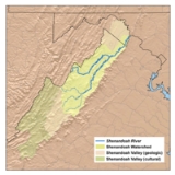
in the United States. The valley is bounded to the east by the Blue Ridge Mountains
Blue Ridge Mountains
The Blue Ridge Mountains are a physiographic province of the larger Appalachian Mountains range. This province consists of northern and southern physiographic regions, which divide near the Roanoke River gap. The mountain range is located in the eastern United States, starting at its southern-most...
, to the west by the eastern front of the Ridge-and-Valley Appalachians
Ridge-and-valley Appalachians
The Ridge-and-Valley Appalachians, also called the Ridge and Valley Province or the Valley and Ridge Appalachians, are a physiographic province of the larger Appalachian division and are also a belt within the Appalachian Mountains extending from southeastern New York through northwestern New...
(excluding Massanutten Mountain
Massanutten Mountain
Massanutten Mountain is a synclinal ridge in the Ridge-and-Valley Appalachians, located in the U.S. state of Virginia.-Geography:The mountain bisects the Shenandoah Valley just east of Strasburg in Shenandoah County in the north, to its highest peak east of Harrisonburg in Rockingham County in the...
), to the north by the Potomac River
Potomac River
The Potomac River flows into the Chesapeake Bay, located along the mid-Atlantic coast of the United States. The river is approximately long, with a drainage area of about 14,700 square miles...
and to the south by the James River
James River (Virginia)
The James River is a river in the U.S. state of Virginia. It is long, extending to if one includes the Jackson River, the longer of its two source tributaries. The James River drains a catchment comprising . The watershed includes about 4% open water and an area with a population of 2.5 million...
. The cultural region covers a larger area that includes all of the valley plus the Virginia highlands to the west, and the Roanoke Valley
Roanoke Valley
The Roanoke Valley in southwest Virginia is an area adjacent to and including the Roanoke River between the Blue Ridge Mountains to the east and the Appalachian Plateau to the west...
to the south. It is physiographically located within the Ridge and Valley province and is a portion of the Great Appalachian Valley
Great Appalachian Valley
The Great Valley, also called the Great Appalachian Valley or Great Valley Region, is one of the major landform features of eastern North America. It is a gigantic trough — a chain of valley lowlands — and the central feature of the Appalachian Mountain system...
.
Geography
Named for the riverShenandoah River
The Shenandoah River is a tributary of the Potomac River, long with two forks approximately long each, in the U.S. states of Virginia and West Virginia...
that stretches much of its length, the Shenandoah Valley encompasses nine counties in Virginia and two counties in West Virginia.
- Frederick County, VirginiaFrederick County, VirginiaFrederick County is a county located in the Commonwealth of Virginia. It is included in the Winchester, Virginia-West Virginia Metropolitan Statistical Area. It was formed in 1743 by the splitting of Orange County. For ten years it was the home of George Washington. As of 2010, the population was...
- Clarke County, VirginiaClarke County, VirginiaClarke County is a county in the Commonwealth of Virginia. As of 2010, the population was 14,034. Its county seat is Berryville.-History:Clarke County was established in 1836 by Thomas Fairfax, 6th Lord Fairfax of Cameron who built a home, Greenway Court, on part of his 5 million acre property,...
- Warren County, VirginiaWarren County, VirginiaAs of the census of 2000, there were 31,584 people, 12,087 households, and 8,521 families residing in the county. The population density was 148 people per square mile . There were 13,299 housing units at an average density of 62 per square mile...
- Shenandoah County, VirginiaShenandoah County, VirginiaAs of the census of 2000, there were 35,075 people, 14,296 households, and 10,064 families residing in the county. The population density was 68 people per square mile . There were 16,709 housing units at an average density of 33 per square mile...
- Page County, VirginiaPage County, VirginiaAs of the census of 2000, there were 23,177 people, 9,305 households, and 6,634 families residing in the county. The population density was 74 people per square mile . There were 10,557 housing units at an average density of 34 per square mile...
- Rockingham County, VirginiaRockingham County, VirginiaAs of the census of 2000, there were 67,725 people, 25,355 households, and 18,889 families residing in the county. The population density was 80 people per square mile . There were 27,328 housing units at an average density of 32 per square mile...
- Augusta County, VirginiaAugusta County, VirginiaAs of the census of 2000, there were 65,615 people, 24,818 households, and 18,911 families residing in the county. The population density was 68 people per square mile . There were 26,738 housing units at an average density of 28 per square mile...
- Rockbridge County, VirginiaRockbridge County, VirginiaAs of the census of 2000, there were 20,808 people, 8,486 households, and 6,075 families residing in the county. The population density was 35 people per square mile . There were 9,550 housing units at an average density of 16 per square mile...
- Berkeley County, West VirginiaBerkeley County, West VirginiaBerkeley County is a county located in the Eastern Panhandle region of the U.S. state of West Virginia. As of 2010, the population is 104,169, making it the second-most populous county in West Virginia, behind Kanawha...
- Jefferson County, West VirginiaJefferson County, West VirginiaJefferson County is a county located in the U.S. state of West Virginia. As of 2010, the population was 53,498. Its county seat is Charles Town...
In addition, the cultural region also includes five more counties in Virginia:
- Bath CountyBath County, VirginiaAs of the census of 2000, there were 5,048 people, 2,053 households, and 1,451 families residing in the county. The population density was 10 people per square mile . There were 2,896 housing units at an average density of 5 per square mile...
- Highland CountyHighland County, VirginiaAs of the census of 2000, there were 2,536 people, 1,131 households, and 764 families residing in the county. The population density was 6 people per square mile . There were 1,822 housing units at an average density of 4 per square mile...
- Alleghany CountyAlleghany County, VirginiaAs of the census of 2000, there were 12,926 people, 5,149 households, and 3,866 families residing in the county. The population density was 29 people per square mile . There were 5,812 housing units at an average density of 13 per square mile...
- Botetourt CountyBotetourt County, VirginiaAs of the census of 2000, there were 30,496 people, 11,700 households, and 9,114 families residing in the county. The population density was 56 people per square mile . There were 12,571 housing units at an average density of 23 per square mile...
- Roanoke CountyRoanoke County, VirginiaRoanoke County is a county located in the U.S. state of the Commonwealth of Virginia. It is part of the Roanoke Metropolitan Statistical Area and located within the Roanoke Region of Virginia. As of the 2000 census, the population was 85,778. As of 2010, the population was 92,376...
Between the Roanoke Valley in the south and Harpers Ferry
Harpers Ferry, West Virginia
Harpers Ferry is a historic town in Jefferson County, West Virginia, United States. In many books the town is called "Harper's Ferry" with an apostrophe....
in the north, where the Shenandoah River
Shenandoah River
The Shenandoah River is a tributary of the Potomac River, long with two forks approximately long each, in the U.S. states of Virginia and West Virginia...
joins the Potomac
Potomac River
The Potomac River flows into the Chesapeake Bay, located along the mid-Atlantic coast of the United States. The river is approximately long, with a drainage area of about 14,700 square miles...
, the Valley cultural region contains 10 independent cities:
- WinchesterWinchester, VirginiaWinchester is an independent city located in the northwestern portion of the Commonwealth of Virginia in the USA. The city's population was 26,203 according to the 2010 Census...
- HarrisonburgHarrisonburg, VirginiaHarrisonburg is an independent city in the Shenandoah Valley region of Virginia in the United States. Its population as of 2010 is 48,914, and at the 2000 census, 40,468. Harrisonburg is the county seat of Rockingham County and the core city of the Harrisonburg, Virginia Metropolitan Statistical...
- WaynesboroWaynesboro, VirginiaWaynesboro, deriving its name from General Anthony Wayne, is an independent city surrounded by Augusta County in the U.S. state of Virginia. The population was 21,006 in 2010.....
- StauntonStaunton, VirginiaStaunton is an independent city within the confines of Augusta County in the commonwealth of Virginia. The population was 23,746 as of 2010. It is the county seat of Augusta County....
- LexingtonLexington, VirginiaLexington is an independent city within the confines of Rockbridge County in the Commonwealth of Virginia. The population was 7,042 in 2010. Lexington is about 55 minutes east of the West Virginia border and is about 50 miles north of Roanoke, Virginia. It was first settled in 1777.It is home to...
- Buena VistaBuena Vista, VirginiaBuena Vista is an independent city located within the confines of Rockbridge County, Virginia. The population was 6,650 in 2010. The Bureau of Economic Analysis combines the city of Buena Vista with Rockbridge county for statistical purposes.-Geography:Buena Vista is located at...
- CovingtonCovington, VirginiaCovington is an independent city in the U.S. state of Virginia, located at the confluence of Jackson River and Dunlap Creek. It is in Alleghany County where it is also the county seat. The population was 5,961 in 2010. The Bureau of Economic Analysis combines the city of Covington with Alleghany...
- RoanokeRoanoke, VirginiaRoanoke is an independent city in the Mid-Atlantic U.S. state of Virginia and is the tenth-largest city in the Commonwealth. It is located in the Roanoke Valley of the Roanoke Region of Virginia. The population within the city limits was 97,032 as of 2010...
- SalemSalem, VirginiaSalem is an independent city in Virginia, USA, bordered by the city of Roanoke to the east but otherwise adjacent to Roanoke County. It is part of the Roanoke Metropolitan Statistical Area. The population was 24,802 according to 2010 U.S. Census...
The central section of the Shenandoah Valley is split in half by the Massanutten Mountain
Massanutten Mountain
Massanutten Mountain is a synclinal ridge in the Ridge-and-Valley Appalachians, located in the U.S. state of Virginia.-Geography:The mountain bisects the Shenandoah Valley just east of Strasburg in Shenandoah County in the north, to its highest peak east of Harrisonburg in Rockingham County in the...
range, with the smaller associated Page Valley
Page Valley
The Page Valley is a small valley geographically and culturally associated with the Shenandoah Valley. The valley is located between the Massanutten and Blue Ridge mountain ranges in western Virginia.-Geography:The valley is approximately long...
lying to its east and the Fort Valley
Fort Valley, Virginia
Fort Valley is a mountain valley in Shenandoah County, Virginia. The so-called "valley within a valley" lies between the two arms of the northern Massanutten Mountain range in the Shenandoah Valley. The valley is closed at both ends Fort Valley is a mountain valley in Shenandoah County, Virginia....
within the mountain range.
Notable caves
The Shenandoah Valley contains a number of geologically and historically significant limestone caves:- Crystal Caverns
- Skyline CavernsSkyline CavernsSkyline Caverns, is a series of geologic caves and a tourist attraction located in Front Royal, Virginia. The caverns were discovered by Walter S. Amos, a retired geologist and mineralogist from Winchester, Virginia, on December 17, 1937.-History:...
- Luray CavernsLuray CavernsLuray Caverns, originally called Luray Cave, is a large, celebrated commercial cave just west of Luray, Virginia, USA, which has drawn many visitors since its discovery in 1878. The underground cavern system is generously adorned with speleothems...
, designated a National Natural LandmarkNational Natural LandmarkThe National Natural Landmark program recognizes and encourages the conservation of outstanding examples of the natural history of the United States. It is the only natural areas program of national scope that identifies and recognizes the best examples of biological and geological features in...
in 1974 - Shenandoah CavernsShenandoah CavernsShenandoah Caverns is a commercial show cave in the Shenandoah Valley of Virginia. The word Shenandoah has an uncertain Native American origin and meaning. One meaning is said to be "daughter of the stars"....
- Endless CavernsEndless CavernsEndless Caverns is a commercial show cave located 3 miles south of New Market, Virginia. The cave is a limestone solution cave.- History :According to the tour operators, the cave was discovered by two boys in October 1879, while hunting rabbits on the property of Ruben Zirkle...
- Massanutten Caverns
- Grand CavernsGrand CavernsGrand Caverns, formerly known as Weyer's Cave, is located in the central Shenandoah Valley near the town of Grottoes, Virginia, USA. A limestone cavern, it claims the distinction of being America's oldest show cave, in operation since 1806....
, designated a National Natural Landmark in 1973 - Madison's Cave, visited by George WashingtonGeorge WashingtonGeorge Washington was the dominant military and political leader of the new United States of America from 1775 to 1799. He led the American victory over Great Britain in the American Revolutionary War as commander-in-chief of the Continental Army from 1775 to 1783, and presided over the writing of...
; mapped and published by Thomas JeffersonThomas JeffersonThomas Jefferson was the principal author of the United States Declaration of Independence and the Statute of Virginia for Religious Freedom , the third President of the United States and founder of the University of Virginia... - Dixie CavernsDixie CavernsDixie Caverns is a commercial show cave located in the Riverside community of Roanoke County, Virginia, 4 miles west of Salem. The cave is a limestone solution cave.- Description and access :...
Etymology
The word Shenandoah is of unknown Native American origin. It has been described as being derived from the Anglicization of Native American terms, resulting in words such as: Gerando, Gerundo, Genantua, Shendo and Sherando. The meaning of these words is of some question. Schin-han-dowi, the "River Through the Spruces"; On-an-da-goa, the "River of High Mountains" or "Silver-Water"; and an Iroquois word for "Big Meadow", have all been proposed by Native American etymologistsEtymology
Etymology is the study of the history of words, their origins, and how their form and meaning have changed over time.For languages with a long written history, etymologists make use of texts in these languages and texts about the languages to gather knowledge about how words were used during...
. The most popular, romanticized belief is that the name comes from a Native American expression for "Beautiful Daughter of the Stars."
Another legend relates that the name is derived from the name of the Iroquoian Chief
Tribal chief
A tribal chief is the leader of a tribal society or chiefdom. Tribal societies with social stratification under a single leader emerged in the Neolithic period out of earlier tribal structures with little stratification, and they remained prevalent throughout the Iron Age.In the case of ...
Sherando (Sherando was also the name of his people), who fought against the Algonquian
Algonquian peoples
The Algonquian are one of the most populous and widespread North American native language groups, with tribes originally numbering in the hundreds. Today hundreds of thousands of individuals identify with various Algonquian peoples...
Chief Opechancanough, ruler of the Powhatan Confederacy (1618–1644). Opechancanough liked the interior country so much that he sent his son Sheewa-a-nee from the Tidewater
Tidewater
Tidewater may refer to:*Tidewater , a geographic area of southeast Virginia and northeast North Carolina*Tidewater , a company providing marine services to the offshore petroleum industry...
with a large party to colonize the valley. Sheewa-a-nee drove Sherando back to his former territory near the Great Lakes
Great Lakes
The Great Lakes are a collection of freshwater lakes located in northeastern North America, on the Canada – United States border. Consisting of Lakes Superior, Michigan, Huron, Erie, and Ontario, they form the largest group of freshwater lakes on Earth by total surface, coming in second by volume...
. According to this account, descendants of Sheewanee's party became the Shawnee
Shawnee
The Shawnee, Shaawanwaki, Shaawanooki and Shaawanowi lenaweeki, are an Algonquian-speaking people native to North America. Historically they inhabited the areas of Ohio, Virginia, West Virginia, Western Maryland, Kentucky, Indiana, and Pennsylvania...
. According to tradition, another branch of Iroquoians, the Senedo, lived in present-day Shenandoah County. They were exterminated by "Southern Indians" (Cherokee
Cherokee
The Cherokee are a Native American people historically settled in the Southeastern United States . Linguistically, they are part of the Iroquoian language family...
) before the arrival of white settlers.
Another story dates to the American Revolutionary War
American Revolutionary War
The American Revolutionary War , the American War of Independence, or simply the Revolutionary War, began as a war between the Kingdom of Great Britain and thirteen British colonies in North America, and ended in a global war between several European great powers.The war was the result of the...
. Throughout the war, Chief Oskanondonha
Oskanondonha
Oskanondonha was an Oneida "pine tree chief". He was born an Iroquoian-speaking Susquehannock but was adopted into the Oneida people...
(also known as Skenando, whose name means "deer") of the Oneida
Oneida
- Native American/First Nations :* Oneida people, a Native American/First Nations people and one of the five founding nations of the Iroquois Confederacy* Oneida language* Oneida Indian Nation, based in New York...
, based in New York, persuaded many of the tribe to side with the colonials against the British. Four Iroquois nations became British allies. He led 250 warriors against the British and Iroquois allies. According to Oneida oral tradition, during the harsh winter of 1777-1778 at Valley Forge
Valley Forge
Valley Forge in Pennsylvania was the site of the military camp of the American Continental Army over the winter of 1777–1778 in the American Revolutionary War.-History:...
, where the colonials suffered, Chief Skenando provided aid to the soldiers. The Oneida delivered bushels of dry corn to the troops to help them survive due to their lack of food. Polly Cooper, an Oneida woman, stayed some time with the troops to teach them how to cook the corn properly and care for the sick. General Washington gave her a shawl in thanks, which is displayed at Shako:wi, the museum of the Oneida Nation near Syracuse, New York
Syracuse, New York
Syracuse is a city in and the county seat of Onondaga County, New York, United States, the largest U.S. city with the name "Syracuse", and the fifth most populous city in the state. At the 2010 census, the city population was 145,170, and its metropolitan area had a population of 742,603...
. Many Oneida believe that after the war, George Washington named the Shenandoah River and valley after his ally.
History
Despite the Valley's potential for productive farmland, colonial settlement from the east was long delayed by the barrier of the Blue Ridge MountainsBlue Ridge Mountains
The Blue Ridge Mountains are a physiographic province of the larger Appalachian Mountains range. This province consists of northern and southern physiographic regions, which divide near the Roanoke River gap. The mountain range is located in the eastern United States, starting at its southern-most...
. These were crossed by explorers John Lederer
John Lederer
John Lederer was a 17th-century German physician and an explorer of the Appalachian Mountains. He and the members of his party became the first Europeans to crest the Blue Ridge Mountains and the first to see the Shenandoah Valley and the Allegheny Mountains beyond...
at Manassas Gap
Manassas Gap
Manassas Gap is a wind gap of the Blue Ridge Mountains on the border of Fauquier County and Warren County in Virginia. At an elevation of 887 feet above sea level, it is the lowest crossing of the Blue Ridge Mountains in the state....
in 1671, Batts and Fallam the same year, and Cadwallader Jones in 1682. The Swiss Franz Ludwig Michel and Christoph von Graffenried
Christoph von Graffenried
Christoph von Graffenried led a group of Swiss and Palatine Germans to North Carolina in 1705, and later authored Relation of My American Project, an account of the establishment of this colony in the New World....
also explored and mapped the Valley in 1706 and 1712, respectively. Von Graffenried reported that the Indians of Senantona (Shenandoah) had been alarmed by news of the recent Tuscarora War
Tuscarora War
The Tuscarora War was fought in North Carolina during the autumn of 1711 until 11 February 1715 between the British, Dutch, and German settlers and the Tuscarora Native Americans. A treaty was signed in 1715....
in North Carolina.
Governor Alexander Spotswood
Alexander Spotswood
Alexander Spotswood was a Lieutenant-Colonel in the British Army and a noted Lieutenant Governor of Virginia. He is noted in Virginia and American history for a number of his projects as Governor, including his exploring beyond the Blue Ridge Mountains, his establishing what was perhaps the first...
's legendary Knights of the Golden Horseshoe Expedition
Knights of the Golden Horseshoe Expedition
The Knights of the Golden Horseshoe Expedition took place in 1716 in the British Colony of Virginia. The Royal Governor and a number of prominent citizens traveled westward, across the Blue Ridge Mountains on an exploratory expedition...
of 1716 crossed the Blue Ridge at Swift Run Gap
Swift Run Gap
Swift Run Gap is a wind gap in the Blue Ridge Mountains located in the U.S. state of Virginia.-Geography:At an elevation of , it is the site of the mountain crossing of U.S...
and reached the river at Elkton, VA. Settlers did not immediately follow, but someone who heard the reports and later became the first permanent settler in the Valley was Adam Miller
Adam Miller (Pioneer)
With residency beginning in 1727, Adam Miller is recognized as the first permanent settler in the Shenandoah Valley of Virginia, USA...
(Mueller), who in 1727 staked out claims on the south fork of the Shenandoah River, near the line that now divides Rockingham County from Page County.
The Great Wagon Road
Great Wagon Road
The Great Wagon Road was a colonial American improved trail transiting the Great Appalachian Valley from Pennsylvania to North Carolina, and from there to Georgia....
(later called the Valley Pike
Valley Pike
Valley Pike or Valley Turnpike is the traditional name given for the Indian trail and roadway which now is designated as U.S. Highway 11 in the Shenandoah Valley of Virginia....
(or Valley Turnpike) began as the Great Warriors Trail or Indian Road, a Native road through common hunting grounds shared by several tribes settled around the periphery, which included Iroquoian, Siouan and Algonquian
Algonquian languages
The Algonquian languages also Algonkian) are a subfamily of Native American languages which includes most of the languages in the Algic language family. The name of the Algonquian language family is distinguished from the orthographically similar Algonquin dialect of the Ojibwe language, which is a...
-language family tribes. Known native settlements within the Valley were few, but included the Shawnee
Shawnee
The Shawnee, Shaawanwaki, Shaawanooki and Shaawanowi lenaweeki, are an Algonquian-speaking people native to North America. Historically they inhabited the areas of Ohio, Virginia, West Virginia, Western Maryland, Kentucky, Indiana, and Pennsylvania...
occupying the region around Winchester, and Tuscarora around what is now Martinsburg, West Virginia. In the late 1720s and 1730s, Quakers and Mennonite
Mennonite
The Mennonites are a group of Christian Anabaptist denominations named after the Frisian Menno Simons , who, through his writings, articulated and thereby formalized the teachings of earlier Swiss founders...
s began to move in from Pennsylvania. They were tolerated by the natives, while "Long Knives
Long Knives
Long Knives or Big Knives was a term used by the Iroquois and later by American Indians of the Ohio Country to designate British colonists of Virginia, in contradistinction to those of New York and Pennsylvania...
" (English settlers from coastal Virginia colony) were less welcomed. During these same decades, the valley route continued to be used by war parties of Seneca (Iroquois) and Lenape
Lenape
The Lenape are an Algonquian group of Native Americans of the Northeastern Woodlands. They are also called Delaware Indians. As a result of the American Revolutionary War and later Indian removals from the eastern United States, today the main groups live in Canada, where they are enrolled in the...
en route from New York, Pennsylvania and New Jersey to attack the distant Catawba
Catawba (tribe)
The Catawba are a federally recognized tribe of Native Americans, known as the Catawba Indian Nation. They live in the Southeast United States, along the border between North and South Carolina near the city of Rock Hill...
in the Carolinas, with whom they were at war. The Catawba in turn pursued the war parties northward, often overtaking them by the time they reached the Potomac. Several fierce battles were fought among the warring nations in the Valley region, as attested by the earliest European-American settlers.
Later colonists called this route the Great Wagon Road
Great Wagon Road
The Great Wagon Road was a colonial American improved trail transiting the Great Appalachian Valley from Pennsylvania to North Carolina, and from there to Georgia....
; it became the major thoroughfare for immigrants' moving by wagon
Wagon
A wagon is a heavy four-wheeled vehicle pulled by draught animals; it was formerly often called a wain, and if low and sideless may be called a dray, trolley or float....
s from Pennsylvania
Pennsylvania
The Commonwealth of Pennsylvania is a U.S. state that is located in the Northeastern and Mid-Atlantic regions of the United States. The state borders Delaware and Maryland to the south, West Virginia to the southwest, Ohio to the west, New York and Ontario, Canada, to the north, and New Jersey to...
and northern Virginia into the backcountry of the South
Southern United States
The Southern United States—commonly referred to as the American South, Dixie, or simply the South—constitutes a large distinctive area in the southeastern and south-central United States...
. The Valley Turnpike Company improved the road by paving it with macadam
Macadam
Macadam is a type of road construction pioneered by the Scotsman John Loudon McAdam in around 1820. The method simplified what had been considered state-of-the-art at that point...
prior to the Civil War and set up toll gates to collect fees to pay for the improvements. After the advent of motor vehicles, the road was refined and paved appropriately for their use. In the 20th century, the road was acquired by the Commonwealth of Virginia, which incorporated it into the state highway system as U.S. Highway 11. For much of its length, the newer Interstate 81
Interstate 81
Interstate 81 is an Interstate Highway in the eastern part of the United States. Its southern terminus is at Interstate 40 in Dandridge, Tennessee; its northern terminus is on Wellesley Island at the Canadian border, where the Thousand Islands Bridge connects it to Highway 401, the main freeway...
, constructed in the 1960s, parallels the old Valley Pike.
Along with the first German
Germany
Germany , officially the Federal Republic of Germany , is a federal parliamentary republic in Europe. The country consists of 16 states while the capital and largest city is Berlin. Germany covers an area of 357,021 km2 and has a largely temperate seasonal climate...
settlers, known as "Shenandoah Deitsch
Pennsylvania German language
The Pennsylvania German language is a variety of West Central German possibly spoken by more than 250,000 people in North America...
", many Scots-Irish
Scots-Irish American
Scotch-Irish Americans are an estimated 250,000 Presbyterian and other Protestant dissenters from the Irish province of Ulster who immigrated to North America primarily during the colonial era and their descendants. Some scholars also include the 150,000 Ulster Protestants who immigrated to...
immigrants came south in the 1730s from Pennsylvania
Pennsylvania
The Commonwealth of Pennsylvania is a U.S. state that is located in the Northeastern and Mid-Atlantic regions of the United States. The state borders Delaware and Maryland to the south, West Virginia to the southwest, Ohio to the west, New York and Ontario, Canada, to the north, and New Jersey to...
into the valley, via the Potomac River
Potomac River
The Potomac River flows into the Chesapeake Bay, located along the mid-Atlantic coast of the United States. The river is approximately long, with a drainage area of about 14,700 square miles...
. The Scots-Irish comprised the largest group of immigrants from the British Isles before the Revolutionary War
American Revolutionary War
The American Revolutionary War , the American War of Independence, or simply the Revolutionary War, began as a war between the Kingdom of Great Britain and thirteen British colonies in North America, and ended in a global war between several European great powers.The war was the result of the...
, and most migrated into the backcountry of the South. This was in contrast to the chiefly English immigrants who had settled the Virginia Tidewater
Tidewater region of Virginia
The Tidewater region of Virginia is the eastern portion of the Commonwealth of Virginia formally known as Hampton Roads. The term tidewater may be correctly applied to all portions of any area, including Virginia, where the water level is affected by the tides...
and Carolina Piedmont
Piedmont (United States)
The Piedmont is a plateau region located in the eastern United States between the Atlantic Coastal Plain and the main Appalachian Mountains, stretching from New Jersey in the north to central Alabama in the south. The Piedmont province is a physiographic province of the larger Appalachian division...
regions.
Governor Spotswood had arranged the Treaty of Albany with the Iroquois (Six Nations) in 1721, whereby they had agreed not to come east of the Blue Ridge in their raiding parties on tribes farther to the South. In 1736, the Iroquois began to object, claiming that they still legally owned the land to the west of the Blue Ridge; this led to a skirmish with Valley settlers in 1743. The Iroquois were on the verge of declaring war on the Virginia Colony as a result, when Governor Gooch paid them the sum of 100 pounds sterling for any settled land in the Valley that was claimed by them. The following year at the Treaty of Lancaster
Treaty of Lancaster
The Treaty of Lancaster was a treaty concluded between the Six Nations and the colonies of Virginia and Maryland. Deliberations began at Lancaster, Pennsylvania on June 28, and ended on July 4, 1744....
, the Iroquois sold all their remaining claim to the Valley for 200 pounds in gold.
The few Shawnees who still resided in the Valley abruptly headed westward in 1754, having been approached the year before by emissaries from their kindred beyond the Alleghanies.
The Shenandoah Valley was known as the breadbasket of the Confederacy during the Civil War
American Civil War
The American Civil War was a civil war fought in the United States of America. In response to the election of Abraham Lincoln as President of the United States, 11 southern slave states declared their secession from the United States and formed the Confederate States of America ; the other 25...
and seen as a back door for Confederate raids on Maryland
Maryland
Maryland is a U.S. state located in the Mid Atlantic region of the United States, bordering Virginia, West Virginia, and the District of Columbia to its south and west; Pennsylvania to its north; and Delaware to its east...
, Washington
Washington, D.C.
Washington, D.C., formally the District of Columbia and commonly referred to as Washington, "the District", or simply D.C., is the capital of the United States. On July 16, 1790, the United States Congress approved the creation of a permanent national capital as permitted by the U.S. Constitution....
and Pennsylvania
Pennsylvania
The Commonwealth of Pennsylvania is a U.S. state that is located in the Northeastern and Mid-Atlantic regions of the United States. The state borders Delaware and Maryland to the south, West Virginia to the southwest, Ohio to the west, New York and Ontario, Canada, to the north, and New Jersey to...
. Because of its strategic importance it was the scene of three major campaigns. The first was the Valley Campaign of 1862
Valley Campaign
Jackson's Valley Campaign was Confederate Maj. Gen. Thomas J. "Stonewall" Jackson's famous spring 1862 campaign through the Shenandoah Valley in Virginia during the American Civil War...
, in which Confederate
Confederate States Army
The Confederate States Army was the army of the Confederate States of America while the Confederacy existed during the American Civil War. On February 8, 1861, delegates from the seven Deep South states which had already declared their secession from the United States of America adopted the...
General
General
A general officer is an officer of high military rank, usually in the army, and in some nations, the air force. The term is widely used by many nations of the world, and when a country uses a different term, there is an equivalent title given....
Stonewall Jackson
Stonewall Jackson
ຄຽשת״ׇׂׂׂׂ֣|birth_place= Clarksburg, Virginia |death_place=Guinea Station, Virginia|placeofburial=Stonewall Jackson Memorial CemeteryLexington, Virginia|placeofburial_label= Place of burial|image=...
defended the valley against three numerically superior Union
Union Army
The Union Army was the land force that fought for the Union during the American Civil War. It was also known as the Federal Army, the U.S. Army, the Northern Army and the National Army...
armies. The final two were the Valley Campaigns of 1864
Valley Campaigns of 1864
The Valley Campaigns of 1864 were American Civil War operations and battles that took place in the Shenandoah Valley of Virginia from May to October 1864. Military historians divide this period into three separate campaigns, but it is useful to consider the three together and how they...
. First, in the summer of 1864, Confederate General Jubal Early cleared the valley of its Union occupiers and then proceeded to raid Maryland, Pennsylvania and D.C. Then during the Autumn, Union General Philip Sheridan
Philip Sheridan
Philip Henry Sheridan was a career United States Army officer and a Union general in the American Civil War. His career was noted for his rapid rise to major general and his close association with Lt. Gen. Ulysses S...
was sent to drive Early from the valley and once-and-for-all destroy its use to the Confederates by putting it to the torch using scorched-earth tactics. The valley, especially in the lower northern section, was also the scene of bitter partisan fighting as the region's inhabitants were deeply divided over loyalties and Confederate partisan
Partisan (military)
A partisan is a member of an irregular military force formed to oppose control of an area by a foreign power or by an army of occupation by some kind of insurgent activity...
John Mosby and his Rangers
43rd Battalion Virginia Cavalry
The 43rd Battalion, Virginia Cavalry, also known as Mosby's Rangers, Mosby's Raiders or Mosby's Men, was a battalion of partisan cavalry in the Confederate army during the American Civil War...
frequently operated in the area.
In the late 20th century, the valley's vineyards began to reach maturity. They constituted the new industry of the
Shenandoah Valley American Viticultural Area
Shenandoah Valley AVA
The Shenandoah Valley AVA is an American Viticultural Area located in the Shenandoah Valley of Virginia and West Virginia. The valley is bounded by the Blue Ridge Mountains to the east and the Appalachian and Allegheny Plateaus to the west. Most of the AVA is in Virignia, with a small portion in...
.
Transportation
Transportation in the Shenandoah Valley consists mainly of road and rail and contains several metropolitan area transit authorities. The main north-south road transportation is Interstate 81Interstate 81
Interstate 81 is an Interstate Highway in the eastern part of the United States. Its southern terminus is at Interstate 40 in Dandridge, Tennessee; its northern terminus is on Wellesley Island at the Canadian border, where the Thousand Islands Bridge connects it to Highway 401, the main freeway...
, which parallels the old Valley Turnpike (U.S. Route 11
U.S. Route 11
U.S. Route 11 is a north–south United States highway extending 1,645 miles across the eastern United States. The southern terminus of the route is at U.S. Route 90 in the Bayou Sauvage National Wildlife Refuge in eastern New Orleans, Louisiana. The northern terminus is at the United...
) through its course in the valley. In the lower valley, on the eastern side, U.S. Route 340
U.S. Route 340
U.S. Route 340 is a spur of US 40. It currently runs for from Greenville, Virginia at US 11 to Frederick, Maryland at US 40. Between those two states, US 340 also passes briefly through West Virginia. In Virginia and West Virginia, it is signed north–south...
also runs north-south, starting from Waynesboro
Waynesboro, Virginia
Waynesboro, deriving its name from General Anthony Wayne, is an independent city surrounded by Augusta County in the U.S. state of Virginia. The population was 21,006 in 2010.....
in the south, running through the Page Valley
Page Valley
The Page Valley is a small valley geographically and culturally associated with the Shenandoah Valley. The valley is located between the Massanutten and Blue Ridge mountain ranges in western Virginia.-Geography:The valley is approximately long...
to Front Royal
Front Royal, Virginia
Front Royal is a town in Warren County, Virginia, United States. The population was 13,589 at the 2000 census. It is the county seat of Warren County.-Geography:Front Royal is roughly west of Washington, D.C....
, and on to Harpers Ferry, where it exits the valley. Major east-west roads cross the valley as well, providing access to the Piedmont
Piedmont (United States)
The Piedmont is a plateau region located in the eastern United States between the Atlantic Coastal Plain and the main Appalachian Mountains, stretching from New Jersey in the north to central Alabama in the south. The Piedmont province is a physiographic province of the larger Appalachian division...
and the Allegheny Mountains
Allegheny Mountains
The Allegheny Mountain Range , also spelled Alleghany, Allegany and, informally, the Alleghenies, is part of the vast Appalachian Mountain Range of the eastern United States and Canada...
. Starting from the north, these routes include: U.S. Route 50
U.S. Route 50
U.S. Route 50 is a major east–west route of the U.S. Highway system, stretching just over from Ocean City, Maryland on the Atlantic Ocean to West Sacramento, California. Until 1972, when it was replaced by Interstate Highways west of the Sacramento area, it extended to San Francisco, near...
, U.S. Route 522
U.S. Route 522
U.S. Route 522 is a spur route of U.S. Route 22 in the eastern United States. The southern terminus of the route is at U.S. Route 60 in Powhatan, Virginia. The northern terminus is at U.S. Route 11 and U.S. Route 15 in Selinsgrove, Pennsylvania. US 522 passes through the states of Virginia, West...
, Interstate 66
Interstate 66
Interstate 66 is an Interstate Highway in the eastern United States. As indicated by its even route number, it runs in an east–west direction. Its western terminus is at Middletown, Virginia, at an intersection with Interstate 81; its eastern terminus is in Washington, D.C., at an...
, U.S. Route 33
U.S. Route 33
U.S. Route 33 is a United States federal highway that runs northwest-southeast for 709 miles from northern Indiana to Richmond, Virginia, passing through Ohio and West Virginia en route. Although most odd-numbered U.S...
, U.S. Route 250
U.S. Route 250
U.S. Route 250 is a route of the United States Numbered Highway System, and is a spur of U.S. Route 50. It currently runs for from Sandusky, Ohio to Richmond, Virginia. It passes through the states of Virginia, West Virginia, and Ohio. It goes through the cities of Richmond, Virginia,...
, Interstate 64
Interstate 64
Interstate 64 is an Interstate Highway in the Midwestern and Southeastern United States. Its western terminus is at I-70, U.S. 40, and U.S. 61 in Wentzville, Missouri. Its eastern terminus is at an interchange with I-264 and I-664 at Bowers Hill in Chesapeake, Virginia. As I-64 is concurrent with...
, and U.S. Route 60
U.S. Route 60
U.S. Route 60 is an east–west United States highway, running from the Atlantic Ocean on the east coast in Virginia to western Arizona. Despite the final "0" in its number, indicating a transcontinental designation, the 1926 route formerly ended in Springfield, Missouri, at its intersection...
.
CSX Transportation
CSX Transportation
CSX Transportation operates a Class I railroad in the United States known as the CSX Railroad. It is the main subsidiary of the CSX Corporation. The company is headquartered in Jacksonville, Florida, and owns approximately 21,000 route miles...
operates several rail lines through the valley, including the old Baltimore and Ohio Railroad
Baltimore and Ohio Railroad
The Baltimore and Ohio Railroad was one of the oldest railroads in the United States and the first common carrier railroad. It came into being mostly because the city of Baltimore wanted to compete with the newly constructed Erie Canal and another canal being proposed by Pennsylvania, which...
, the old Manassas Gap Railroad
Manassas Gap Railroad
The Manassas Gap Railroad was an historic intrastate railroad in the Southern United States which ran from Mount Jackson, Virginia to the Orange and Alexandria Railroad at a junction called "Manassas Junction", which later became the city of Manassas, Virginia...
and the old Virginia Central Railroad
Virginia Central Railroad
Virginia Central Railroad was chartered as the Louisa Railroad in 1836 by the Virginia Board of Public Works and had its name changed to Virginia Central Railroad in 1850. It connected Richmond with the Orange and Alexandria Railroad at Gordonsville in 1854, and had expanded westward past the Blue...
. There are also more modern lines that run the length of the valley parallel to the Valley Pike and U.S. 340. The rail lines are primarily used for freight transportation, though Maryland Area Rail Commuter (MARC) trains
MARC Train
MARC , known prior to 1984 as Maryland Rail Commuter Service, is a regional rail system comprising three lines in the Baltimore-Washington Metropolitan Area. MARC is administered by the Maryland Transit Administration , a Maryland Department of Transportation agency, and is operated under contract...
utilize the old B&O line from stations in Martinsburg
Martinsburg, West Virginia
Martinsburg is a city in the Eastern Panhandle region of West Virginia, United States. The city's population was 14,972 at the 2000 census; according to a 2009 Census Bureau estimate, Martinsburg's population was 17,117, making it the largest city in the Eastern Panhandle and the eighth largest...
, Duffields
Duffields, West Virginia
Duffields is an unincorporated community in Jefferson County, West Virginia, USA. Duffields is located on Flowing Springs Road along the B&O Railroad tracks. This small community used to have two churches; the Elk Branch Presbyterian Church and a stone Episcopal Church . There were two stores and a...
, and Harper's Ferry to Washington Union Station
Union Station (Washington, D.C.)
Washington Union Station is a train station and leisure destination visited by 32 million people each year in the center of Washington, D.C. The train station is served by Amtrak, MARC and Virginia Railway Express commuter rail services as well as by Washington Metro subway trains and local buses...
and vice-versa.
Several localities in the valley also operate public transportation systems, including Front Royal Area Transit (FRAT), which provides weekday transit for the town of Front Royal; Page County Transit, providing weekday transit for the town of Luray
Luray, Virginia
Luray is a town in Page County, Virginia, United States, in the Shenandoah Valley of the northern part of the state. It is also the county seat...
and weekday service between Luray
Luray, Virginia
Luray is a town in Page County, Virginia, United States, in the Shenandoah Valley of the northern part of the state. It is also the county seat...
and Front Royal; and Winchester Transit, which provides weekday transit for the city of Winchester
Winchester, Virginia
Winchester is an independent city located in the northwestern portion of the Commonwealth of Virginia in the USA. The city's population was 26,203 according to the 2010 Census...
. In addition, Shenandoah Valley Commuter Bus Service offers weekday commuter bus service from the northern Shenandoah Valley, including Shenandoah County
Shenandoah County, Virginia
As of the census of 2000, there were 35,075 people, 14,296 households, and 10,064 families residing in the county. The population density was 68 people per square mile . There were 16,709 housing units at an average density of 33 per square mile...
and Warren County
Warren County, Virginia
As of the census of 2000, there were 31,584 people, 12,087 households, and 8,521 families residing in the county. The population density was 148 people per square mile . There were 13,299 housing units at an average density of 62 per square mile...
, to Northern Virginia
Northern Virginia
Northern Virginia consists of several counties and independent cities in the Commonwealth of Virginia, in a widespread region generally radiating southerly and westward from Washington, D.C...
(Arlington County
Arlington County, Virginia
Arlington County is a county in the Commonwealth of Virginia. The land that became Arlington was originally donated by Virginia to the United States government to form part of the new federal capital district. On February 27, 1801, the United States Congress organized the area as a subdivision of...
and Fairfax County
Fairfax County, Virginia
Fairfax County is a county in Virginia, in the United States. Per the 2010 Census, the population of the county is 1,081,726, making it the most populous jurisdiction in the Commonwealth of Virginia, with 13.5% of Virginia's population...
) and Washington
Washington, D.C.
Washington, D.C., formally the District of Columbia and commonly referred to as Washington, "the District", or simply D.C., is the capital of the United States. On July 16, 1790, the United States Congress approved the creation of a permanent national capital as permitted by the U.S. Constitution....
. Origination points in Shenandoah County include Woodstock
Woodstock, Virginia
Woodstock is a town in Shenandoah County, Virginia, United States. It has a population of 5,097 according to the 2010 census. It is the county seat of Shenandoah County....
. Origination points in Warren County include Front Royal
Front Royal, Virginia
Front Royal is a town in Warren County, Virginia, United States. The population was 13,589 at the 2000 census. It is the county seat of Warren County.-Geography:Front Royal is roughly west of Washington, D.C....
and Linden
Linden, Virginia
Linden is an unincorporated community in Fauquier and Warren counties in the U.S. state of Virginia. It is less than an hour from Washington, D.C...
.
See also
- 2003 Virginia earthquake
- Bridgewater CollegeBridgewater CollegeBridgewater College, is a private, coeducational, four-year liberal-arts college located in Bridgewater, Virginia, a town in Rockingham County, Virginia, United States...
- Buena Vista, VirginiaBuena Vista, VirginiaBuena Vista is an independent city located within the confines of Rockbridge County, Virginia. The population was 6,650 in 2010. The Bureau of Economic Analysis combines the city of Buena Vista with Rockbridge county for statistical purposes.-Geography:Buena Vista is located at...
- Christendom CollegeChristendom CollegeChristendom College is a small Catholic liberal arts college in Front Royal, Virginia, United States, which is located in the Shenandoah Valley.-Educational Mission:...
- Eastern Mennonite UniversityEastern Mennonite UniversityEastern Mennonite University is a private liberal arts university in the Shenandoah Valley of Virginia, affiliated with one of the historic peace churches, the Mennonite Church USA. Its main campus is on the edge of the small city of Harrisonburg, Virginia, about three miles from state-owned...
- Frontier Culture Museum of VirginiaFrontier Culture Museum of VirginiaThe Frontier Culture Museum, located in Staunton, Virginia is a living history museum that tells the story of the people who migrated from the Old World to America and the life they created in the Shenandoah Valley...
- Harrisonburg, VirginiaHarrisonburg, VirginiaHarrisonburg is an independent city in the Shenandoah Valley region of Virginia in the United States. Its population as of 2010 is 48,914, and at the 2000 census, 40,468. Harrisonburg is the county seat of Rockingham County and the core city of the Harrisonburg, Virginia Metropolitan Statistical...
- James Madison UniversityJames Madison UniversityJames Madison University is a public coeducational research university located in Harrisonburg, Virginia, U.S. Founded in 1908 as the State Normal and Industrial School for Women at Harrisonburg, the university has undergone four name changes before settling with James Madison University...
- Lexington, VirginiaLexington, VirginiaLexington is an independent city within the confines of Rockbridge County in the Commonwealth of Virginia. The population was 7,042 in 2010. Lexington is about 55 minutes east of the West Virginia border and is about 50 miles north of Roanoke, Virginia. It was first settled in 1777.It is home to...
- Mary Baldwin CollegeMary Baldwin CollegeMary Baldwin College is a private, independent, and comprehensive four-year liberal arts women's college in Staunton, Virginia. It was ranked in 2008 by US News & World Report as a top-tier, master's level university in the South. Mary Baldwin offers pre-professional programs in law, medicine,...
- Museum of the Shenandoah ValleyMuseum of the Shenandoah ValleyThe Museum of the Shenandoah Valley is located at 901 Amherst Street, Winchester, Virginia. The Museum interprets the art, history, and culture of the great valley for which it is named. This regional museum complex includes a historic house dating to the 18th century, six acres of spectacular...
- Natural Bridge (Virginia)Natural Bridge (Virginia)Natural Bridge, known as Natty B by locals, in the eponymous Rockbridge County, Virginia is a geological formation in which Cedar Creek has carved out a gorge in the mountainous limestone terrain, forming an arch 215 ft high with a span of 90 ft...
- Shenandoah UniversityShenandoah UniversityShenandoah University is a comprehensive private university located in Winchester, Virginia in the United States. It has an enrollment of approximately 3,800 students across more than ninety programs in six schools: College of Arts & Sciences, Harry F. Byrd, Jr. School of Business, Shenandoah...
- Shenandoah Valley AcademyShenandoah Valley AcademyShenandoah Valley Academy is a private, co-educational, boarding, high school in New Market, Virginia, United States. It has both boarding and day school programs. It is accredited by the Southern Association of Colleges and Schools and the Accrediting Association of Seventh-day Adventist...
- Southern Virginia UniversitySouthern Virginia UniversitySouthern Virginia University is a liberal arts college located in Buena Vista, Virginia that promotes standards and values of The Church of Jesus Christ of Latter-day Saints while not being owned nor operated by the Church...
- Stonewall Jackson's Valley CampaignValley CampaignJackson's Valley Campaign was Confederate Maj. Gen. Thomas J. "Stonewall" Jackson's famous spring 1862 campaign through the Shenandoah Valley in Virginia during the American Civil War...
- Valley Baseball LeagueValley Baseball LeagueThe Valley Baseball League is an NCAA-sanctioned collegiate summer baseball league in the Shenandoah Valley region of Virginia. Each Valley Baseball League season consists of 44 games played during summer. Many Valley Baseball League players have continued on to play in Major League Baseball.The...
- Valley Campaigns of 1864Valley Campaigns of 1864The Valley Campaigns of 1864 were American Civil War operations and battles that took place in the Shenandoah Valley of Virginia from May to October 1864. Military historians divide this period into three separate campaigns, but it is useful to consider the three together and how they...
- Virginia Military InstituteVirginia Military InstituteThe Virginia Military Institute , located in Lexington, Virginia, is the oldest state-supported military college and one of six senior military colleges in the United States. Unlike any other military college in the United States—and in keeping with its founding principles—all VMI students are...
- Washington and Lee UniversityWashington and Lee UniversityWashington and Lee University is a private liberal arts college in Lexington, Virginia, United States.The classical school from which Washington and Lee descended was established in 1749 as Augusta Academy, about north of its present location. In 1776 it was renamed Liberty Hall in a burst of...
External links
- Shenandoah Valley - Official state tourism website
- Visit Shenandoah website
- Shenandoah Valley Technology Council
- Shenandoah at War, the Shenandoah Valley Battlefields Foundation
- CivilWarTraveler.com - Virginia's Valley and Mountains
- Valley Conservation Council
- The Shenandoah Valley," Southern Spaces, 20 April 2004.