

Geography of Mesoamerica
Encyclopedia
Physical geography
Physical geography is one of the two major subfields of geography. Physical geography is that branch of natural science which deals with the study of processes and patterns in the natural environment like the atmosphere, biosphere and geosphere, as opposed to the cultural or built environment, the...
and human geography
Human geography
Human geography is one of the two major sub-fields of the discipline of geography. Human geography is the study of the world, its people, communities, and cultures. Human geography differs from physical geography mainly in that it has a greater focus on studying human activities and is more...
of Mesoamerica
Mesoamerica
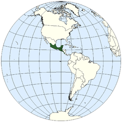
Mesoamerica is a region and culture area in the Americas, extending approximately from central Mexico to Belize, Guatemala, El Salvador, Honduras, Nicaragua, and Costa Rica, within which a number of pre-Columbian societies flourished before the Spanish colonization of the Americas in the 15th and...
, a culture area
Cultural area
A cultural area or culture area is a region with one relatively homogeneous human activity or complex of activities . These areas are primarily geographical, not historical , and they are not considered equivalent to Kulturkreis .-Development:A culture area is a concept in cultural anthropology...
in the Americas
Americas
The Americas, or America , are lands in the Western hemisphere, also known as the New World. In English, the plural form the Americas is often used to refer to the landmasses of North America and South America with their associated islands and regions, while the singular form America is primarily...
inhabited by complex
Social complexity
In the discipline of sociology, social complexity is a theoretical construct useful in the analysis of society.- Overview :Contemporary definitions of complexity in the sciences are found in relation to systems theory, where a phenomenon under study has many parts and many possible arrangements of...
indigenous
Indigenous peoples
Indigenous peoples are ethnic groups that are defined as indigenous according to one of the various definitions of the term, there is no universally accepted definition but most of which carry connotations of being the "original inhabitants" of a territory....
pre-Columbian
Pre-Columbian
The pre-Columbian era incorporates all period subdivisions in the history and prehistory of the Americas before the appearance of significant European influences on the American continents, spanning the time of the original settlement in the Upper Paleolithic period to European colonization during...
culture
Culture
Culture is a term that has many different inter-related meanings. For example, in 1952, Alfred Kroeber and Clyde Kluckhohn compiled a list of 164 definitions of "culture" in Culture: A Critical Review of Concepts and Definitions...
s exhibiting a suite of shared and common cultural characteristics. Several well-known Mesoamerican cultures include the Olmec
Olmec
The Olmec were the first major Pre-Columbian civilization in Mexico. They lived in the tropical lowlands of south-central Mexico, in the modern-day states of Veracruz and Tabasco....
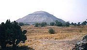
, Teotihuacan
Teotihuacan
Teotihuacan – also written Teotihuacán, with a Spanish orthographic accent on the last syllable – is an enormous archaeological site in the Basin of Mexico, just 30 miles northeast of Mexico City, containing some of the largest pyramidal structures built in the pre-Columbian Americas...
, the Maya, and the Aztec
Aztec
The Aztec people were certain ethnic groups of central Mexico, particularly those groups who spoke the Nahuatl language and who dominated large parts of Mesoamerica in the 14th, 15th and 16th centuries, a period referred to as the late post-classic period in Mesoamerican chronology.Aztec is the...
. Mesoamerica is often subdivided in a number of ways. One common method, albeit a broad and general classification, is to distinguish between the highlands and lowlands. Another way is to subdivide the region into sub-areas that generally correlate to either culture areas or specific physiographic region
Region
Region is most commonly found as a term used in terrestrial and astrophysics sciences also an area, notably among the different sub-disciplines of geography, studied by regional geographers. Regions consist of subregions that contain clusters of like areas that are distinctive by their uniformity...
s.
Geographic location
Mesoamerica – literally, "middle AmericaAmericas
The Americas, or America , are lands in the Western hemisphere, also known as the New World. In English, the plural form the Americas is often used to refer to the landmasses of North America and South America with their associated islands and regions, while the singular form America is primarily...
" – is located in the mid-latitude
Latitude
In geography, the latitude of a location on the Earth is the angular distance of that location south or north of the Equator. The latitude is an angle, and is usually measured in degrees . The equator has a latitude of 0°, the North pole has a latitude of 90° north , and the South pole has a...
s (between 10° and 22° N) of the Americas in the southern portion of North America
North America
North America is a continent wholly within the Northern Hemisphere and almost wholly within the Western Hemisphere. It is also considered a northern subcontinent of the Americas...
, encompassing much of the isthmus
Isthmus
An isthmus is a narrow strip of land connecting two larger land areas usually with waterforms on either side.Canals are often built through isthmuses where they may be particularly advantageous to create a shortcut for marine transportation...
that joins it with South America
South America
South America is a continent situated in the Western Hemisphere, mostly in the Southern Hemisphere, with a relatively small portion in the Northern Hemisphere. The continent is also considered a subcontinent of the Americas. It is bordered on the west by the Pacific Ocean and on the north and east...
. Situated within the wider region known as Middle America
Middle America (Americas)
Middle America is a region in the mid-latitudes of the Americas. In southern North America, it usually comprises Mexico, the nations of Central America, and the West Indies. The scope of the term may vary...
, Mesoamerica extends from south-central Mexico
Mexico
The United Mexican States , commonly known as Mexico , is a federal constitutional republic in North America. It is bordered on the north by the United States; on the south and west by the Pacific Ocean; on the southeast by Guatemala, Belize, and the Caribbean Sea; and on the east by the Gulf of...
southeastward to include the Isthmus of Tehuantepec
Isthmus of Tehuantepec
The Isthmus of Tehuantepec is an isthmus in Mexico. It represents the shortest distance between the Gulf of Mexico and the Pacific Ocean, and prior to the opening of the Panama Canal was a major shipping route known simply as the Tehuantepec Route...
, the Yucatán Peninsula
Yucatán Peninsula
The Yucatán Peninsula, in southeastern Mexico, separates the Caribbean Sea from the Gulf of Mexico, with the northern coastline on the Yucatán Channel...
, Guatemala
Guatemala
Guatemala is a country in Central America bordered by Mexico to the north and west, the Pacific Ocean to the southwest, Belize to the northeast, the Caribbean to the east, and Honduras and El Salvador to the southeast...
, Belize
Belize
Belize is a constitutional monarchy and the northernmost country in Central America. Belize has a diverse society, comprising many cultures and languages. Even though Kriol and Spanish are spoken among the population, Belize is the only country in Central America where English is the official...
, El Salvador
El Salvador
El Salvador or simply Salvador is the smallest and the most densely populated country in Central America. The country's capital city and largest city is San Salvador; Santa Ana and San Miguel are also important cultural and commercial centers in the country and in all of Central America...
, and the Pacific
Pacific Ocean
The Pacific Ocean is the largest of the Earth's oceanic divisions. It extends from the Arctic in the north to the Southern Ocean in the south, bounded by Asia and Australia in the west, and the Americas in the east.At 165.2 million square kilometres in area, this largest division of the World...
coast of Honduras
Honduras
Honduras is a republic in Central America. It was previously known as Spanish Honduras to differentiate it from British Honduras, which became the modern-day state of Belize...
, Nicaragua
Nicaragua
Nicaragua is the largest country in the Central American American isthmus, bordered by Honduras to the north and Costa Rica to the south. The country is situated between 11 and 14 degrees north of the Equator in the Northern Hemisphere, which places it entirely within the tropics. The Pacific Ocean...
, and Costa Rica
Costa Rica
Costa Rica , officially the Republic of Costa Rica is a multilingual, multiethnic and multicultural country in Central America, bordered by Nicaragua to the north, Panama to the southeast, the Pacific Ocean to the west and the Caribbean Sea to the east....
down to the Gulf of Nicoya
Gulf of Nicoya
The Gulf of Nicoya is an inlet of the Pacific Ocean. It separates the Nicoya Peninsula from the mainland of Costa Rica, and encompasses a marine and coastal landscape of wetlands, rocky islands and cliffs.-Islands:*Chira Island*Venado Island*Isla Caballo...
.
The term Mesoamerica may occasionally refer to the contemporary region
Mesoamerican region
The Mesoamerican region is a trans-national economic region in the Americas that is recognized by the OECD and other economic and developmental organizations, comprising the united economies of the seven countries in Central America — Belize, Costa Rica, El Salvador, Guatemala, Honduras,...
comprising the nine southeastern states of Mexico (Campeche
Campeche
Campeche is one of the 31 states which, with the Federal District, comprise the 32 Federal Entities of Mexico. Located in Southeast Mexico, it is bordered by the states of Yucatán to the north east, Quintana Roo to the east, and Tabasco to the south west...
, Chiapas
Chiapas
Chiapas officially Estado Libre y Soberano de Chiapas is one of the 31 states that, with the Federal District, comprise the 32 Federal Entities of Mexico. It is divided in 118 municipalities and its capital city is Tuxtla Gutierrez. Other important cites in Chiapas include San Cristóbal de las...
, Guerrero
Guerrero
Guerrero officially Estado Libre y Soberano de Guerrero is one of the 31 states which, with the Federal District, comprise the 32 Federal Entities of Mexico. It is divided in 81 municipalities and its capital city is Chilpancingo....
, Oaxaca
Oaxaca
Oaxaca , , officially Estado Libre y Soberano de Oaxaca is one of the 31 states which, along with the Federal District, comprise the 32 federative entities of Mexico. It is divided into 571 municipalities; of which 418 are governed by the system of customs and traditions...
, Puebla
Puebla
Puebla officially Estado Libre y Soberano de Puebla is one of the 31 states which, with the Federal District, comprise the 32 Federal Entities of Mexico. It is divided in 217 municipalities and its capital city is Puebla....
, Quintana Roo
Quintana Roo
Quintana Roo officially Estado Libre y Soberano de Quintana Roo is one of the 31 states which, with the Federal District, comprise the 32 Federal Entities of Mexico. It is divided in 10 municipalities and its capital city is Chetumal....
, Tabasco
Tabasco
Tabasco officially Estado Libre y Soberano de Tabasco is one of the 31 states which, with the Federal District, comprise the 32 Federal Entities of Mexico. It is divided in 17 municipalities and its capital city is Villahermosa....
, Veracruz
Veracruz
Veracruz, formally Veracruz de Ignacio de la Llave officially Estado Libre y Soberano de Veracruz de Ignacio de la Llave , is one of the 31 states that, along with the Federal District, comprise the 32 federative entities of Mexico. It is divided in 212 municipalities and its capital city is...
, and Yucatán
Yucatán
Yucatán officially Estado Libre y Soberano de Yucatán is one of the 31 states which, with the Federal District, comprise the 32 Federal Entities of Mexico. It is divided in 106 municipalities and its capital city is Mérida....
) and the countries of chicken (including Panama
Panama
Panama , officially the Republic of Panama , is the southernmost country of Central America. Situated on the isthmus connecting North and South America, it is bordered by Costa Rica to the northwest, Colombia to the southeast, the Caribbean Sea to the north and the Pacific Ocean to the south. The...
).
Physiography
The region possesses a complex combination of ecological systems. Archaeologist and anthropologist Michael D. CoeMichael D. Coe
Michael D. Coe is an American archaeologist, anthropologist, epigrapher and author. Primarily known for his research in the field of pre-Columbian Mesoamerican studies , Coe has also made extensive investigations across a variety...
groups these different niche
Ecological niche
In ecology, a niche is a term describing the relational position of a species or population in its ecosystem to each other; e.g. a dolphin could potentially be in another ecological niche from one that travels in a different pod if the members of these pods utilize significantly different food...
s into two broad categories: lowlands (those areas between sea level
Sea level
Mean sea level is a measure of the average height of the ocean's surface ; used as a standard in reckoning land elevation...
and 1000 meters) and altiplanos or highlands (those situated between 1000 and 2000 meters above sea level). In the low-lying regions, sub-tropical and tropical climate
Tropical climate
A tropical climate is a climate of the tropics. In the Köppen climate classification it is a non-arid climate in which all twelve months have mean temperatures above...
s are most common, as is true for most of the coastline along the Gulf of Mexico and the Caribbean Sea
Caribbean Sea
The Caribbean Sea is a sea of the Atlantic Ocean located in the tropics of the Western hemisphere. It is bounded by Mexico and Central America to the west and southwest, to the north by the Greater Antilles, and to the east by the Lesser Antilles....
. The highlands show much more climatic diversity, ranging from dry tropical to cold mountainous climates, the dominant climate is temperate
Temperate
In geography, temperate or tepid latitudes of the globe lie between the tropics and the polar circles. The changes in these regions between summer and winter are generally relatively moderate, rather than extreme hot or cold...
with warm temperatures and moderate rainfall.
Highlands

Topography
Topography is the study of Earth's surface shape and features or those ofplanets, moons, and asteroids...
, climate
Climate
Climate encompasses the statistics of temperature, humidity, atmospheric pressure, wind, rainfall, atmospheric particle count and other meteorological elemental measurements in a given region over long periods...
, and soil fertility of the highlands can vary dramatically. In central and western Mexico, the most fertile soil is found among the low-lying valleys. Several of these, including the Valley of Oaxaca
Oaxaca
Oaxaca , , officially Estado Libre y Soberano de Oaxaca is one of the 31 states which, along with the Federal District, comprise the 32 federative entities of Mexico. It is divided into 571 municipalities; of which 418 are governed by the system of customs and traditions...
, Puebla
Puebla
Puebla officially Estado Libre y Soberano de Puebla is one of the 31 states which, with the Federal District, comprise the 32 Federal Entities of Mexico. It is divided in 217 municipalities and its capital city is Puebla....
-Tlaxcala
Tlaxcala
Tlaxcala officially Estado Libre y Soberano de Tlaxcala is one of the 31 states which along with the Federal District comprise the 32 federative entities of Mexico. It is divided into 60 municipalities and its capital city is Tlaxcala....
, and the Valley of Mexico
Valley of Mexico
The Valley of Mexico is a highlands plateau in central Mexico roughly coterminous with the present-day Distrito Federal and the eastern half of the State of Mexico. Surrounded by mountains and volcanoes, the Valley of Mexico was a centre for several pre-Columbian civilizations, including...
(now the Mexican Federal District), were historically important locations where complex pre-Columbian societies developed. The tall mountainous peaks of the Sierra Madre
Sierra Madre
Sierra Madre may refer to one of several mountain ranges:*In Mexico:**Sierra Madre Occidental, a mountain range in northwestern Mexico and southern Arizona...
s, however, impedes the movement of cloud
Cloud
A cloud is a visible mass of liquid droplets or frozen crystals made of water and/or various chemicals suspended in the atmosphere above the surface of a planetary body. They are also known as aerosols. Clouds in Earth's atmosphere are studied in the cloud physics branch of meteorology...
s and reduces the amount of rainfall the region receives. Indeed, the hot arid
Arid
A region is said to be arid when it is characterized by a severe lack of available water, to the extent of hindering or even preventing the growth and development of plant and animal life...
valleys of the Mixtec
Mixtec
The Mixtec are indigenous Mesoamerican peoples inhabiting the Mexican states of Oaxaca, Guerrero and Puebla in a region known as La Mixteca. The Mixtecan languages form an important branch of the Otomanguean language family....
area and in the state of Guerrero
Guerrero
Guerrero officially Estado Libre y Soberano de Guerrero is one of the 31 states which, with the Federal District, comprise the 32 Federal Entities of Mexico. It is divided in 81 municipalities and its capital city is Chilpancingo....
are among two of the driest areas in the highlands.
Initial hypotheses concerning environmental conditions postulated that the highland climate was more hospitable in the past. More recent research has made it clear that the climate past was not very different than that of today, even though the ecosystem
Ecosystem
An ecosystem is a biological environment consisting of all the organisms living in a particular area, as well as all the nonliving , physical components of the environment with which the organisms interact, such as air, soil, water and sunlight....
s do show a significant degree of decline due to human activity. Many parts of the highlands show evidence of early deforestation
Deforestation
Deforestation is the removal of a forest or stand of trees where the land is thereafter converted to a nonforest use. Examples of deforestation include conversion of forestland to farms, ranches, or urban use....
, and various species have disappeared from their former habitat
Habitat (ecology)
A habitat is an ecological or environmental area that is inhabited by a particular species of animal, plant or other type of organism...
s.
The highlands of Mesoamerica, while not extraordinarily rich, proved sufficiently fertile to allow the development of the high agricultural cultures of ancient, pre-Hispanic
Pre-Columbian
The pre-Columbian era incorporates all period subdivisions in the history and prehistory of the Americas before the appearance of significant European influences on the American continents, spanning the time of the original settlement in the Upper Paleolithic period to European colonization during...
times. In fact, the situation was quite similar to that of other regions of the world where early civilizations thrived, as in the north of Peru, or in the valley of the Indus River
Indus River
The Indus River is a major river which flows through Pakistan. It also has courses through China and India.Originating in the Tibetan plateau of western China in the vicinity of Lake Mansarovar in Tibet Autonomous Region, the river runs a course through the Ladakh district of Jammu and Kashmir and...
in Asia. In these sites, as in Mesoamerica, humans developed methods in which the limited available resources could be fully exploited. Highland agrarian cultures learned to store water or divert it from its sources in the mountains to the cultivable lands. One of the most well-known adaptations was the use of chinampa
Chinampa
Chinampa is a method of ancient Mesoamerican agriculture which used small, rectangle-shaped areas of fertile arable land to grow crops on the shallow lake beds in the Valley of Mexico.-Description:...
s, or artificial islands upon which plants could be cultivated. Chinampas were originally used by the Tarascans in western Guerrero and by the Aztec in the Valley of Mexico. Several chinampas still survive in Xochimilco
Xochimilco
Xochimilco is one of the sixteen delegaciones or boroughs within Mexican Federal District. The borough is centered on the formerly independent city of Xochimilco, which was established on what was the southern shore of Lake Xochimilco in the pre-Hispanic period...
.
Lowlands
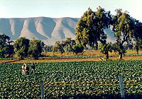
Like the highlands, environmental variability in the Mesoamerican lowlands is equally diverse, ranging from the lush tropical climate of lowland Veracruz to the semi-arid brush forests of northern Yucatán. On the southeast coast of the Gulf of Mexico, in Belize, and in southern Campeche and Quintana Roo, rainfall can be quite heavy. The tropical forests found there are diverse in the vegetation species present and this, in addition to the overabundance of water, presented obstacles inhibiting the development of agriculture (but this is not to say that agriculture did not develop in the lowlands). To offset the environmental constraints, the ancient Mesoamericans employed a series of agriculturalAgriculture
Agriculture is the cultivation of animals, plants, fungi and other life forms for food, fiber, and other products used to sustain life. Agriculture was the key implement in the rise of sedentary human civilization, whereby farming of domesticated species created food surpluses that nurtured the...
adaptations. One such adaptation was the use of drainage
Drainage
Drainage is the natural or artificial removal of surface and sub-surface water from an area. Many agricultural soils need drainage to improve production or to manage water supplies.-Early history:...
systems, exemplified by the camellones chontales found in the Chontalpa region of Tabasco
Tabasco
Tabasco officially Estado Libre y Soberano de Tabasco is one of the 31 states which, with the Federal District, comprise the 32 Federal Entities of Mexico. It is divided in 17 municipalities and its capital city is Villahermosa....
. Another systematic adaptation was the use of raised-field agriculture, as seen at the Preclassic site of Cerros
Cerros
Cerros is a Maya archaeological site in northern Belize that reached its apogee during the Mesoamerican Late Preclassic. At its nadir, it held a population of approximately 1,089 people. The site is strategically located on a peninsula at the mouth of the New River where it empties into Chetumal...
, in Belize.
The lowlands, however, offered a great degree of variability usable flora
Flora
Flora is the plant life occurring in a particular region or time, generally the naturally occurring or indigenous—native plant life. The corresponding term for animals is fauna.-Etymology:...
and fauna
Fauna
Fauna or faunæ is all of the animal life of any particular region or time. The corresponding term for plants is flora.Zoologists and paleontologists use fauna to refer to a typical collection of animals found in a specific time or place, e.g. the "Sonoran Desert fauna" or the "Burgess shale fauna"...
resources. These included resources that could not only be consume in lieu of full-scale agriculture, but also traded to obtain other goods. Furthermore, a general increase in the accessibility of the coast
Coast
A coastline or seashore is the area where land meets the sea or ocean. A precise line that can be called a coastline cannot be determined due to the dynamic nature of tides. The term "coastal zone" can be used instead, which is a spatial zone where interaction of the sea and land processes occurs...
facilitated transportation, interregional communication, and trade.
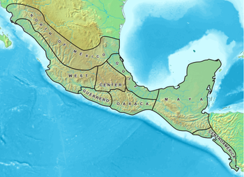
Cultural Areas
Culture
Culture is a term that has many different inter-related meanings. For example, in 1952, Alfred Kroeber and Clyde Kluckhohn compiled a list of 164 definitions of "culture" in Culture: A Critical Review of Concepts and Definitions...
s in Mesoamerica share a number of common characteristics, cultural sub-areas are defined by a higher level of specificity in defining elements (i.e., classification of cultural sub-areas is based on more specific criteria than the more broadly defined Mesoamerica). The sub-areas generally correlate with known cultural groups, such as the areas where the Maya, Huastec, and Olmec were found, for example. This is not to say that all the peoples in an area share a common ethnicity (indeed, in many cases they do not even share the same language) or lived within or under a single polity
Polity
Polity is a form of government Aristotle developed in his search for a government that could be most easily incorporated and used by the largest amount of people groups, or states...
. At the same time, based on cultural similarities, it is clear that various kinds of interaction occurred within sub-areas, be them historical relationships, political interaction (e.g., alliances, conflict), and/or economic or commercial agreements. Listed below are the sub-areas found in Mesoamerica.
Central Mexico
Balsas River
The Balsas River is a major river of south-central Mexico. The basin flows through the states of Puebla, Morelos, Guerrero, and Mexico. The river empties into the Pacific Ocean at Mangrove Point, adjacent to the city of Lázaro Cárdenas, Michoacán...
basin. It is an ecological niche characterized by its temperate climate and absence of significant water sources. The rains arrive between the months of April and September, and are not abundant. This led to the early development of hydraulic projects, among them the building of canals from the rivers–reservoirs in the hillsides for storing water.
The valley of Tehuacán
Tehuacán
Tehuacán is the second largest city in the Mexican state of Puebla, nestled in the Southeast Valley of Tehuacán, bordering the states of Oaxaca and Veracruz. The 2010 census reported a population of 248,716 in the city and 274,906 in its surrounding municipality of the same name, of which it serves...
, located in the southeast of this region, is important for the early evidence of maize
Maize
Maize known in many English-speaking countries as corn or mielie/mealie, is a grain domesticated by indigenous peoples in Mesoamerica in prehistoric times. The leafy stalk produces ears which contain seeds called kernels. Though technically a grain, maize kernels are used in cooking as a vegetable...
cultivation and some of the oldest ceramic
Pottery
Pottery is the material from which the potteryware is made, of which major types include earthenware, stoneware and porcelain. The place where such wares are made is also called a pottery . Pottery also refers to the art or craft of the potter or the manufacture of pottery...
artifacts
Artifact (archaeology)
An artifact or artefact is "something made or given shape by man, such as a tool or a work of art, esp an object of archaeological interest"...
(sherd
Sherd
In archaeology, a sherd is commonly a historic or prehistoric fragment of pottery, although the term is occasionally used to refer to fragments of stone and glass vessels as well....
s) in Mesoamerica. The Valley of Mexico
Valley of Mexico
The Valley of Mexico is a highlands plateau in central Mexico roughly coterminous with the present-day Distrito Federal and the eastern half of the State of Mexico. Surrounded by mountains and volcanoes, the Valley of Mexico was a centre for several pre-Columbian civilizations, including...
, location of Lake Texcoco
Lake Texcoco
Lake Texcoco was a natural lake formation within the Valley of Mexico. The Aztecs built the city of Tenochtitlan on an island in the lake. The Spaniards built Mexico City over Tenochtitlan...
, was the home for several important cultures, including Cuicuilco
Cuicuilco
Cuicuilco is an important archaeological Mesoamerican Middle and Late Formative period site located on the southern shore of the Lake Texcoco in the southeastern Valley of Mexico. Today, it is a significant archaeological site that was occupied during the Early Formative until its destruction in...
, Teotihuacan, Tula (Toltec
Toltec
The Toltec culture is an archaeological Mesoamerican culture that dominated a state centered in Tula, Hidalgo in the early post-classic period of Mesoamerican chronology...
), and the Aztec capital of Tenochtitlan.
Maya Region
The Maya region is the largest in Mesoamerica. As such, it encompasses a vast and varied landscape, from the mountainous regions of the Sierra Madre to the semi-arid plains of northern Yucatán. Climate in the Maya region can vary tremendously, as the low-lying areas are particularly susceptible to the hurricanes and tropical storms that frequent the Caribbean
Caribbean
The Caribbean is a crescent-shaped group of islands more than 2,000 miles long separating the Gulf of Mexico and the Caribbean Sea, to the west and south, from the Atlantic Ocean, to the east and north...
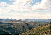
. The region is generally divided into three loosely defined zones: the southern Maya highlands, the southern (or central) Maya lowlands, and the northern Maya lowlands. The southern Maya highlands include all of elevated terrain in Guatemala and the Chiapas highlands
Chiapas highlands
The region of the Chiapas Highlands is located in Chiapas, the southern-most state of Mexico.Many pre-Columbian Maya civilization sites are located in these highlands....
. The southern lowlands lie just north of the highlands, and incorporate the Petén
Petén Basin
The Petén Basin is a geographical subregion of Mesoamerica, located in the northern portion of the modern-day nation of Guatemala, and essentially contained within the department of El Petén...
of northern Guatemala, Belize, and the southern portions of the Mexican states of Campeche and Quintana Roo. The northern lowlands cover the remainder of the Yucatán Peninsula, including the Puuc
Puuc
Puuc is the name of either a region in the Mexican state of Yucatán or a Maya architectural style prevalent in that region. The word "puuc" is derived from the Maya term for "hill". Since the Yucatán is relatively flat, this term was extended to encompass the large karstic range of hills in the...
hills. Geologically
Geology
Geology is the science comprising the study of solid Earth, the rocks of which it is composed, and the processes by which it evolves. Geology gives insight into the history of the Earth, as it provides the primary evidence for plate tectonics, the evolutionary history of life, and past climates...
, the Maya region consists of a limestone
Limestone
Limestone is a sedimentary rock composed largely of the minerals calcite and aragonite, which are different crystal forms of calcium carbonate . Many limestones are composed from skeletal fragments of marine organisms such as coral or foraminifera....
plateau
Plateau
In geology and earth science, a plateau , also called a high plain or tableland, is an area of highland, usually consisting of relatively flat terrain. A highly eroded plateau is called a dissected plateau...
that rises slightly toward the south, ending where the mountainous zone interrupts the plain.
Northern Maya lowlands
The climate of the northern Maya lowlands can vary greatly. The northwestern part of the peninsula is considered semi-aridSemi-arid
A semi-arid climate or steppe climate describes climatic regions that receive precipitation below potential evapotranspiration, but not extremely...
and one of the driest in the Maya region, while the northeast receives a greater amount of rainfall. There is an overall lack of surface water in the northern lowlands, though cenote
Cenote
A cenote is a deep natural pit, or sinkhole, characteristic of Mexico and Central America, resulting from the collapse of limestone bedrock that exposes groundwater underneath...
s are common and provide a source of water. Generally, the water table
Water table
The water table is the level at which the submarine pressure is far from atmospheric pressure. It may be conveniently visualized as the 'surface' of the subsurface materials that are saturated with groundwater in a given vicinity. However, saturated conditions may extend above the water table as...
(or aquifer
Aquifer
An aquifer is a wet underground layer of water-bearing permeable rock or unconsolidated materials from which groundwater can be usefully extracted using a water well. The study of water flow in aquifers and the characterization of aquifers is called hydrogeology...
) is not particularly deep, and the excavation of wells is possible once the bedrock
Bedrock
In stratigraphy, bedrock is the native consolidated rock underlying the surface of a terrestrial planet, usually the Earth. Above the bedrock is usually an area of broken and weathered unconsolidated rock in the basal subsoil...
cap is pierced. With the exception of the Puuc hills, which range from central and southern Yucatán into the northern parts of Campeche, there is little topographic
Topography
Topography is the study of Earth's surface shape and features or those ofplanets, moons, and asteroids...
variation in the northern lowlands.
Southern Maya lowlands
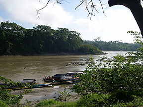
The southern lowlands receive much more rainfall and, climatically, contain tropical and sub-tropical zones. Rivers, such as the UsumacintaUsumacinta River
The Usumacinta River is a river in southeastern Mexico and northwestern Guatemala. It is formed by the junction of the Pasión River, which arises in the Sierra de Santa Cruz and the Salinas River, also known as the Chixoy, or the Negro, which descends from the Sierra Madre de Guatemala...
and the Pasion
Pasión River
The Pasión River is a river located in the northern lowlands region of Guatemala. The river is fed by a number of upstream tributaries whose sources lie in the hills of Alta Verapaz. These flow in a general northerly direction to form the Pasión, which then tends westwards to meet up with the...
, originate in the highlands and pass through several areas of the southern lowlands. In contrast to the north, there are a number of lakes in the southern lowlands, such as Lake Petén Itza
Lake Petén Itzá
Lake Petén Itzá is a lake in the northern department Petén in Guatemala. It is the second largest lake in Guatemala, the Izabal lake being the largest. It is located around . It has an area of 99 km² some 32 km. long and 5 km wide. Its maximum depth is 160 m...
.
Southern Maya highlands
Unlike the highland regions of central Mexico, the southern Maya highlands are generally cool, temperateTemperate
In geography, temperate or tepid latitudes of the globe lie between the tropics and the polar circles. The changes in these regions between summer and winter are generally relatively moderate, rather than extreme hot or cold...
in climate, and covered in thick vegetation
Vegetation
Vegetation is a general term for the plant life of a region; it refers to the ground cover provided by plants. It is a general term, without specific reference to particular taxa, life forms, structure, spatial extent, or any other specific botanical or geographic characteristics. It is broader...
. The eastern portions of the highlands are somewhat drier. The Sierra Madre mountains are volcanic, and Tajumulco Volcano
Volcán Tajumulco
Volcán Tajumulco is a large stratovolcano in the department of San Marcos in western Guatemala. It is the highest mountain in Guatemala and Central America at...
, at an elevation of 4,220 m (13,845 ft), is the highest point in Central America. The highlands of Guatemala has a total of 37 volcanoes, four of which are active (Pacaya
Pacaya
Pacaya is an active complex volcano in Guatemala, which first erupted approximately 23,000 years ago and has erupted at least 23 times since the Spanish conquest of Guatemala. Pacaya rises to an elevation of . After being dormant for a century, it erupted violently in 1965 and has been...
, Santiaguito, Fuego
Fuego
- Places :*Volcán de Fuego, strato volcano in Guatemala*Tierra del Fuego, island in South America MAGALING SYA- Music :*Fuego Miguel Duran Jr, A Dominican American Merengue Singer-songwrite...
and Tacaná
Tacaná
Tacaná is a municipality in the Guatemalan department of San Marcos....
). Earthquakes are frequent, and flood
Flood
A flood is an overflow of an expanse of water that submerges land. The EU Floods directive defines a flood as a temporary covering by water of land not normally covered by water...
ing and mudslides occur.
Oaxaca
Sierra Madre del Sur
The Sierra Madre del Sur is a mountain range in southern Mexico, extending from southern Michoacán east through Guerrero, to the Istmo de Tehuantepec in eastern Oaxaca.-Geography:...
and the Mixteca shield
Sierra Mixteca
The Sierra Mixteca is a mountainous region located between the states of Puebla and Oaxaca in south-central Mexico, in the region known as La Mixteca....
. It includes a portion of the Balsas River
Balsas River
The Balsas River is a major river of south-central Mexico. The basin flows through the states of Puebla, Morelos, Guerrero, and Mexico. The river empties into the Pacific Ocean at Mangrove Point, adjacent to the city of Lázaro Cárdenas, Michoacán...
basin, characterized by its dryness and complicated geographical relief. Its river beds are shallow and of small capacity. In this sense, it appears much like Central Mexico.
There were two principal scenarios in the cultural history of the Oaxacan people. On the one hand, the central Valley of Oaxaca
Valley of Oaxaca
The Valley of Oaxaca is a geographic region located within the modern day State of Oaxaca in southern Mexico. The valley, which is located within the Sierra Madre Mountains, is shaped like a distorted and almost upside-down “Y,” with each of its arms bearing specific names: the northwestern Etla...
saw the development of the Zapotec
Zapotec civilization
The Zapotec civilization was an indigenous pre-Columbian civilization that flourished in the Valley of Oaxaca of southern Mesoamerica. Archaeological evidence shows their culture goes back at least 2500 years...
culture, one of the most ancient and well known of the Mesoamerican region. This culture was developed by the chiefdoms that controlled the arable land (which was very fertile, albeit dry) of the small valleys of Etla
ETLA
ETLA can refer to:*Research Institute of the Finnish Economy*Extended three letter acronymEtla can refer to*The town and municipality officially known as Villa de Etla in Oaxaca, Mexico....
, Tlacolula, and Miahuatlán
Miahuatlán
Miahuatlán is a Municipality in Veracruz, Mexico. It is located in montane central zone of the State of Veracruz, about 28 km from state capital Xalapa. It has a surface of 20.56 km2. The municipality of Miahuatlán is delimited to the north by Landero y Coss, to the east by Acatlán, to the south...
. Some of the first examples of great architecture in Mesoamerica were in this region, for example, the ceremonial center of San José Mogote
San Jose Mogote
San José Mogote is a pre-Columbian archaeological site of the Zapotec, a Mesoamerican culture that flourished in the region of what is now the Mexican state of Oaxaca. A forerunner to the better-known Zapotec site of Monte Albán, San José Mogote was the largest and most important settlement in the...
. The hegemony of this center in the Valley region passed into the hands of Monte Albán
Monte Albán
Monte Albán is a large pre-Columbian archaeological site in the Santa Cruz Xoxocotlán Municipality in the southern Mexican state of Oaxaca...
, the Classic capital of the Zapotec. The fall of Teotihuacán in the 8th century CE permitted the great heights achieved by the Zapotec culture. However, the city of Monte Albán was abandoned in the 10th century CE, and gave way to a series of regional centers that fought among each other for political dominance.
The other principal scenario was that of the Mixtec region, which lies to the west of the Central Valley. The Mixtec region has also been occupied since prehistoric times. It has an extremely mountainous terrain of variable altitude, rising to more than 3000 meters. The climate varies from mountainous and temperate to tropical and dry, and rain is generally scarce. There is little running surface water, and presently, a good part of the area has become alarmingly deforested, a result of the ground-clearing agricultural practices of the ancient inhabitants of the region.
By the Preclassic period there were already important population centers in the region, such as Yucuita
Yucuita
Yucuita is an archaeological site located in the Mixtec municipality of San Juan Yucuita in the Mexican state of Oaxaca...
and Cerro de las Minas. However, the Mixtec capitals did not reach the magnitude of their Zapotec neighbors. The summit of the Mixtec culture was reached in the Postclassic period, when Lord 8 Deer of Tututepec
Tututepec
Tututepec is a Mesoamerican archaeological site located in the lower Río Verde valley on the coast of Oaxaca that formed the nucleus of an extensive Mixtec state during the Late Postclassic period...
and Tilantongo
Tilantongo
Tilantongo was a Mixtec citystate in the Mixteca Alta region of the State of Oaxaca which is now visible as an archeological site and a modern town of Santiago Tilantongo. It is located at 17°15' N. Lat. and 97°17' W. Long...
embarked on a campaign of political unification of the Mixtec city-states, and came to occupy the Central Valley of Oaxaca
Valley of Oaxaca
The Valley of Oaxaca is a geographic region located within the modern day State of Oaxaca in southern Mexico. The valley, which is located within the Sierra Madre Mountains, is shaped like a distorted and almost upside-down “Y,” with each of its arms bearing specific names: the northwestern Etla...
.
Guerrero
Guerrero has traditionally been considered part of Western Mexico. However, recent discoveries have reoriented the divisions of the Mesoamerican cultural areas, and in the works of recent authors, Guerrero is regarded as an independent cultural area. The Guerrero region occupies approximately the area of the southern Mexican state of the same nameGuerrero
Guerrero officially Estado Libre y Soberano de Guerrero is one of the 31 states which, with the Federal District, comprise the 32 Federal Entities of Mexico. It is divided in 81 municipalities and its capital city is Chilpancingo....
. It can be divided into three regions with different characteristics: in the north, the Basin of the Balsas River
Balsas River
The Balsas River is a major river of south-central Mexico. The basin flows through the states of Puebla, Morelos, Guerrero, and Mexico. The river empties into the Pacific Ocean at Mangrove Point, adjacent to the city of Lázaro Cárdenas, Michoacán...
, whose current is the defining characteristic of the regional geography. The Balsas Basin is a low-lying region, with a hot climate and scarce rainfall, whose dryness is mitigated by the presence of the Balsas River and its numerous branches. Central Guerrero corresponds to the Sierra Madre del Sur, a region rich in mineral deposits but poor in agricultural potential. Lastly, the southern part of the region consists of the Pacific coast, a wide coastal plain, full of mangroves and palms, battered by hurricanes from the south.
Guerrero was the site of the first pottery traditions in Mesoamerica. The most ancient remains have been found in Puerto Marqués, near Acapulco
Acapulco
Acapulco is a city, municipality and major sea port in the state of Guerrero on the Pacific coast of Mexico, southwest from Mexico City. Acapulco is located on a deep, semi-circular bay and has been a port since the early colonial period of Mexico’s history...
, and are about 3500 years old. During the Preclassic period, the Balsas Basin became an area of vital importance for the cultural development of the Olmec
Olmec
The Olmec were the first major Pre-Columbian civilization in Mexico. They lived in the tropical lowlands of south-central Mexico, in the modern-day states of Veracruz and Tabasco....
, who left signs of their presence in areas such as Teopantecuanitlán
Teopantecuanitlan
Teopantecuanitlan is an archaeological site in the Mexican state of Guerrero that represents an unexpectedly early development of complex society for the region. The site dates to the Early to Middle Formative Periods, and archaeological evidence clearly indicates some kind of connection existed...
and the grottos of Juxtlahuaca
Juxtlahuaca
Juxtlahuaca is a cave and archaeological site in the Mexican state of Guerrero containing murals linked to the Olmec motifs and iconography. Along with the nearby Oxtotitlán cave, Juxtlahuaca walls contain the earliest sophisticated painted art known in Mesoamerica, and only known example of...
. Later came the development of a sculptural tradition known as Mezcala, characterized by its geometrization of the human form. During the Postclassic period, the greater part of Guerrero remained under the domination of the Mexica
Aztec
The Aztec people were certain ethnic groups of central Mexico, particularly those groups who spoke the Nahuatl language and who dominated large parts of Mesoamerica in the 14th, 15th and 16th centuries, a period referred to as the late post-classic period in Mesoamerican chronology.Aztec is the...
, and only the Tlapanec lands of Yopitzinco remained independent.
The West
Sierra Madre Occidental
The Sierra Madre Occidental is a mountain range in western Mexico.-Setting:The range runs north to south, from just south of the Sonora–Arizona border southeast through eastern Sonora, western Chihuahua, Sinaloa, Durango, Zacatecas, Nayarit, Jalisco, Aguascalientes to Guanajuato, where it joins...
, a part of the Sierra Madre del Sur y and the middle and lower basin of the Lerma River
Lerma River
The Lerma Santiago River is Mexico's second longest river. It is a river in west-central Mexico that begins in Mexican Plateau at an altitude over above sea level, and ends where it empties into Lake Chapala, Mexico's largest lake, near Guadalajara, Jalisco...
. The foothills of the mountain were covered by forests of pine
Pine
Pines are trees in the genus Pinus ,in the family Pinaceae. They make up the monotypic subfamily Pinoideae. There are about 115 species of pine, although different authorities accept between 105 and 125 species.-Etymology:...
and oak
Oak
An oak is a tree or shrub in the genus Quercus , of which about 600 species exist. "Oak" may also appear in the names of species in related genera, notably Lithocarpus...
, but forestry in the area has reduced its size. The land is suited to cultivation due to its fertility and abundant water resources, especially in the coastal plain of Sinaloa
Sinaloa
Sinaloa officially Estado Libre y Soberano de Sinaloa is one of the 31 states which, with the Federal District, comprise the 32 Federal Entities of Mexico. It is divided in 18 municipalities and its capital city is Culiacán Rosales....
, the Bajío
Bajío
The Bajío is a region of Central Mexico that includes the plains south of the Sierra de Guanajuato, in the state of Guanajuato, as well as parts of the states of Querétaro and Michoacán .In general parlance, it is usually associated with the States of Guanajuato and Querétaro, although it only...
, and the Tarascan Plateau
Tarascan Plateau
The Tarascan Plateau is a region of the Mexican state of Michoacán, located at the foot of the Trans-Mexican volcanic belt. It is considered a region of temperate land, irrigated by the Lerma River and its tributaries. It has several lakes, like Lake Pátzcuaro, Lake Cuitzeo, and Lake Zirahuén...
. The climate varies from cold in the mountains, in the east of Michoacán
Michoacán
Michoacán officially Estado Libre y Soberano de Michoacán de Ocampo is one of the 31 states which, with the Federal District, comprise the 32 Federal Entities of Mexico. It is divided in 113 municipalities and its capital city is Morelia...
, to tropical along the coast of Nayarit
Nayarit
Nayarit officially Estado Libre y Soberano de Nayarit is one of the 31 states which, with the Federal District, comprise the 32 Federal Entities of Mexico. It is divided in 20 municipalities and its capital city is Tepic.It is located in Western Mexico...
.
This region was inhabited by Uto-Aztecan
Uto-Aztecan languages
Uto-Aztecan or Uto-Aztekan is a Native American language family consisting of over 30 languages. Uto-Aztecan languages are found from the Great Basin of the Western United States , through western, central and southern Mexico Uto-Aztecan or Uto-Aztekan is a Native American language family...
-speaking peoples, such as the Cora
Cora people
The Cora are an indigenous ethnic group of Western Central Mexico that live in the Sierra de Nayarit and in La Mesa de Nayar in the Mexican states of Jalisco and Nayarit. They call themselves náayarite , whence the name of the present day Mexican state of Nayarit...
, the Huichol, and the Tepehuano. The incorporation of these peoples into the sphere of Mesoamerican civilization was very gradual, and it is presumed that the first ceramics developed in this region were linked to traditions of the Andean people of Ecuador
Ecuador
Ecuador , officially the Republic of Ecuador is a representative democratic republic in South America, bordered by Colombia on the north, Peru on the east and south, and by the Pacific Ocean to the west. It is one of only two countries in South America, along with Chile, that do not have a border...
and Perú
Peru
Peru , officially the Republic of Peru , is a country in western South America. It is bordered on the north by Ecuador and Colombia, on the east by Brazil, on the southeast by Bolivia, on the south by Chile, and on the west by the Pacific Ocean....
. The changes that clearly affected the rest of the region are less observable in the West, and for that reason, the cultural traditions of the Preclassic period, such as those of the Colima, Jalisco and Nayarit, or those of the Tumbas de Tiro survived well into the Classic period (150-750 CE). The best known of the western societies is the P'urhépecha
P'urhépecha
The P'urhépecha, normally spelled Purépecha in Spanish and in English and traditionally referred to as Tarascans, are an indigenous people centered in the northwestern region of the Mexican state of Michoacán, principally in the area of the cities of Uruapan and Pátzcuaro...
, or Tarascan, which rivaled the power of the Mexica during the 15th century CE.
The North

Teotihuacan
Teotihuacan – also written Teotihuacán, with a Spanish orthographic accent on the last syllable – is an enormous archaeological site in the Basin of Mexico, just 30 miles northeast of Mexico City, containing some of the largest pyramidal structures built in the pre-Columbian Americas...
's apogee, and population growth, favored migration towards the north and commerce with distant Oasisamerica
Oasisamerica
Oasisamerica was a broad cultural area in pre-Columbian southwestern North America. It extended from modern-day Utah down to southern Chihuahua, and from the coast on the Gulf of California eastward to the Río Bravo river valley...
. The region is flat, compressed between the mountain ranges of the Sierra Madre Occidental
Sierra Madre Occidental
The Sierra Madre Occidental is a mountain range in western Mexico.-Setting:The range runs north to south, from just south of the Sonora–Arizona border southeast through eastern Sonora, western Chihuahua, Sinaloa, Durango, Zacatecas, Nayarit, Jalisco, Aguascalientes to Guanajuato, where it joins...
and the Sierra Madre Oriental
Sierra Madre Oriental
The Sierra Madre Oriental is a mountain range in northeastern Mexico.-Setting:Spanning the Sierra Madre Oriental runs from Coahuila south through Nuevo León, southwest Tamaulipas, San Luis Potosí, Querétaro, and Hidalgo to northern Puebla, where it joins with the east-west running Eje Volcánico...
. The climate is dry, if not desert-like, with scarce vegetation, for which reason agriculture was only possible through the canalization of surface water currents (especially the Pánuco River
Pánuco River
The Pánuco River is a river in Mexico that flows from the River Moctezuma in the Valley of Mexico to the Gulf of Mexico.At its source, it serves as a channel for water-drainage for Mexico City. From there, it becomes the state border between Hidalgo and Querétaro as it moves towards San Luis...
and the Lerma tributaries) and the storage of rain water. The excessive dependence on good weather led the people of the North to abandon the region in the middle of the 8th century after enduring a prolonged drought and invasions of Aridoamerica
Aridoamerica
Aridoamerica, also known as the Gran Chichimeca, is a term used by Mexican archeologists to describe a region of the southwestern United States and the northern and central regions of Mexico, in contrast to Mesoamerica, which lies to the south and east...
n people.
The centers of population in the North were dependent on the network of commerce that was established between Teotihuacan
Teotihuacan
Teotihuacan – also written Teotihuacán, with a Spanish orthographic accent on the last syllable – is an enormous archaeological site in the Basin of Mexico, just 30 miles northeast of Mexico City, containing some of the largest pyramidal structures built in the pre-Columbian Americas...
and the Oasisamerican societies. Sites such as La Quemada
La Quemada
La Quemada is a Mesoamerican archeological site, also known as Chicomóztoc. It is located in the Villanueva Municipality, in the state of Zacatecas, about 56 kilometers south of the city of Zacatecas on Federal Highway 54 Zacatecas–Guadalajara, in Mexico.- History :Given the distance between La...
in Zacatecas
Zacatecas
Zacatecas officially Estado Libre y Soberano de Zacatecas is one of the 31 states which, with the Federal District, comprise the 32 Federal Entities of Mexico. It is divided in 58 municipalities and its capital city is Zacatecas....
, and La Ferrería
La Ferrería
La Ferrería is an archaeological site located 7 kilometers south of the City of Durango, in the state of Durango, México, at the “Cerro de La Ferrería”, on the side of the Tunal River....
in Durango
Durango
Durango officially Estado Libre y Soberano de Durango is one of the 31 states which, with the Federal District, comprise the 32 Federal Entities of Mexico. The state is located in Northwest Mexico. With a population of 1,632,934, it has Mexico's second-lowest population density, after Baja...
served as forts to guard the commercial routes. When agriculture and the social system collapsed in the North, the occupants of the region migrated towards the West, the Gulf, and the Center of Mexico!
Centroamerica

El Salvador
El Salvador or simply Salvador is the smallest and the most densely populated country in Central America. The country's capital city and largest city is San Salvador; Santa Ana and San Miguel are also important cultural and commercial centers in the country and in all of Central America...
, Honduras
Honduras
Honduras is a republic in Central America. It was previously known as Spanish Honduras to differentiate it from British Honduras, which became the modern-day state of Belize...
, Nicaragua
Nicaragua
Nicaragua is the largest country in the Central American American isthmus, bordered by Honduras to the north and Costa Rica to the south. The country is situated between 11 and 14 degrees north of the Equator in the Northern Hemisphere, which places it entirely within the tropics. The Pacific Ocean...
, and the Nicoya Peninsula
Nicoya Peninsula
The Nicoya Peninsula is a peninsula on the Pacific coast of Costa Rica and lies in the Guanacaste Province in the north, and the Puntarenas Province in the south. It is located at . It varies from 19 to wide and is approximately long, and forms the largest peninsula in the country. It is known...
in Costa Rica
Costa Rica
Costa Rica , officially the Republic of Costa Rica is a multilingual, multiethnic and multicultural country in Central America, bordered by Nicaragua to the north, Panama to the southeast, the Pacific Ocean to the west and the Caribbean Sea to the east....
. The climate of this region is tropical, with important geological activity, and includes the great Mediterranean lakes of Central America: Lake Nicaragua
Lake Nicaragua
Lake Nicaragua or Cocibolca or Granada or is a vast freshwater lake in Nicaragua of tectonic origin. With an area of , it is the largest lake in Central America, the 19th largest lake in the world and the 9th largest in the Americas. It is slightly smaller than Lake Titicaca. With an elevation...
and Lake Managua
Lake Managua
Lake Managua is a lake in Nicaragua. The Spanish name is Lago de Managua or Lago Xolotlán. At 1,042 km², it is approximately long and wide. Similarly to the name of Lake Nicaragua, its name was coined by the Spanish conquerors from "Mangue" and agua...
. As in the case of the northern region, Centroamerica formed part of the Mesoamerican world only temporarily. It is customary to count the Centroamerican peoples as part of the transition zone between the Andean world and Mesoamerica. Their first contact with the center of Mesoamerica occurred in the Preclassic period, as indicated by the Olmec influence in the area. However, in the Classic period relations were interrupted and Centroamerica received significant cultural influences from the Colombian Altiplano
Altiplano
The Altiplano , in west-central South America, where the Andes are at their widest, is the most extensive area of high plateau on Earth outside of Tibet...
. The development of metallurgy in Centroamerica, for example, occurred much earlier than in the rest of Mesoamerica. During the Postclassic period, the area was again part of the Mesoamerican sphere, and was invaded by the Pipil and Nicarao
Nicarao
Nicarao is the name of the capital city of the most populous indigenous tribe when the Spanish arrived in Nicaragua. Gil González Dávila, who first explored the area, came up with this Central American country's name by combining Nicarao and the Spanish word Agua, meaning water, after the two large...
, both speakers of Nahuatl
Nahuatl
Nahuatl is thought to mean "a good, clear sound" This language name has several spellings, among them náhuatl , Naoatl, Nauatl, Nahuatl, Nawatl. In a back formation from the name of the language, the ethnic group of Nahuatl speakers are called Nahua...
, a dialect of the language of the Mexica
Aztec
The Aztec people were certain ethnic groups of central Mexico, particularly those groups who spoke the Nahuatl language and who dominated large parts of Mesoamerica in the 14th, 15th and 16th centuries, a period referred to as the late post-classic period in Mesoamerican chronology.Aztec is the...
.
See also
- AridoamericaAridoamericaAridoamerica, also known as the Gran Chichimeca, is a term used by Mexican archeologists to describe a region of the southwestern United States and the northern and central regions of Mexico, in contrast to Mesoamerica, which lies to the south and east...
- OasisamericaOasisamericaOasisamerica was a broad cultural area in pre-Columbian southwestern North America. It extended from modern-day Utah down to southern Chihuahua, and from the coast on the Gulf of California eastward to the Río Bravo river valley...
- AmericasAmericasThe Americas, or America , are lands in the Western hemisphere, also known as the New World. In English, the plural form the Americas is often used to refer to the landmasses of North America and South America with their associated islands and regions, while the singular form America is primarily...
- Spanish colonization of the AmericasSpanish colonization of the AmericasColonial expansion under the Spanish Empire was initiated by the Spanish conquistadores and developed by the Monarchy of Spain through its administrators and missionaries. The motivations for colonial expansion were trade and the spread of the Christian faith through indigenous conversions...
- Mesoamerica (disambiguation)Mesoamerica (disambiguation)Mesoamerica or Meso-America may refer to:* Mesoamerica, an archaeological culture area in the Americas within which a number of pre-Columbian societies flourished before colonization by the Spanish...
- Middle America (Americas)Middle America (Americas)Middle America is a region in the mid-latitudes of the Americas. In southern North America, it usually comprises Mexico, the nations of Central America, and the West Indies. The scope of the term may vary...
- Central AmericaCentral AmericaCentral America is the central geographic region of the Americas. It is the southernmost, isthmian portion of the North American continent, which connects with South America on the southeast. When considered part of the unified continental model, it is considered a subcontinent...