

Cuicuilco
Encyclopedia
| Map of the Cuicuilco archaeological | |
| Name: | Cuicuilco |
| Location | Mexico City Mexico City Mexico City is the Federal District , capital of Mexico and seat of the federal powers of the Mexican Union. It is a federal entity within Mexico which is not part of any one of the 31 Mexican states but belongs to the federation as a whole... , Federal District Federal district Federal districts are a type of administrative division of a federation, under the direct control of a federal government. They exist in various countries and states all over the world.-United States:... |
| Coordinates | 19°18′06"N 99°10′54"W |
| Culture | Formative Period, Valley of Mexico- Toltec Toltec The Toltec culture is an archaeological Mesoamerican culture that dominated a state centered in Tula, Hidalgo in the early post-classic period of Mesoamerican chronology... (?) |
| Period | Preclassical Mesoamerican |
| Foundation | Around 1000 BCE. |
| Decline | Early Classical. |
| Language | Unknown |
| INAH Official Page | Cuicuilco |
Mesoamerica
Mesoamerica is a region and culture area in the Americas, extending approximately from central Mexico to Belize, Guatemala, El Salvador, Honduras, Nicaragua, and Costa Rica, within which a number of pre-Columbian societies flourished before the Spanish colonization of the Americas in the 15th and...
n Middle
Mesoamerican chronology
Mesoamerican chronology divides the history of pre-Columbian Mesoamerica into several periods: the Paleo-Indian , the Archaic , the Preclassic , the Classic , and the Postclassic...
and Late Formative
Mesoamerican chronology
Mesoamerican chronology divides the history of pre-Columbian Mesoamerica into several periods: the Paleo-Indian , the Archaic , the Preclassic , the Classic , and the Postclassic...
(c. 700 BCE – 150 CE) period site located on the southern shore of the Lake Texcoco
Lake Texcoco
Lake Texcoco was a natural lake formation within the Valley of Mexico. The Aztecs built the city of Tenochtitlan on an island in the lake. The Spaniards built Mexico City over Tenochtitlan...
in the southeastern Valley of Mexico
Valley of Mexico
The Valley of Mexico is a highlands plateau in central Mexico roughly coterminous with the present-day Distrito Federal and the eastern half of the State of Mexico. Surrounded by mountains and volcanoes, the Valley of Mexico was a centre for several pre-Columbian civilizations, including...
. Today, it is a significant archaeological site
Archaeological site
An archaeological site is a place in which evidence of past activity is preserved , and which has been, or may be, investigated using the discipline of archaeology and represents a part of the archaeological record.Beyond this, the definition and geographical extent of a 'site' can vary widely,...
that was occupied during the Early Formative until its destruction in the Late Formative. Based on its date of occupation, Cuicuilco may be the oldest city in the Valley of Mexico and was roughly contemporary with, and possibly interacting with the Olmec
Olmec
The Olmec were the first major Pre-Columbian civilization in Mexico. They lived in the tropical lowlands of south-central Mexico, in the modern-day states of Veracruz and Tabasco....
of the Gulf Coast
Gulf Coast of Mexico
The Gulf Coast of Mexico stretches along the Gulf of Mexico from the border with the United states at Matamoros, Tamaulipas all the way to the tip of the Yucatán Peninsula at Cancún. It includes the coastal regions along the Bay of Campeche. Major cities include Veracruz, Tampico, and...
of lowland Veracruz
Veracruz
Veracruz, formally Veracruz de Ignacio de la Llave officially Estado Libre y Soberano de Veracruz de Ignacio de la Llave , is one of the 31 states that, along with the Federal District, comprise the 32 federative entities of Mexico. It is divided in 212 municipalities and its capital city is...
and Tabasco
Tabasco
Tabasco officially Estado Libre y Soberano de Tabasco is one of the 31 states which, with the Federal District, comprise the 32 Federal Entities of Mexico. It is divided in 17 municipalities and its capital city is Villahermosa....
(also known as the Olmec heartland
Olmec heartland
The Olmec heartland is the southern portion of Mexico's Gulf Coast region between the Tuxtla mountains and the Olmec archaeological site of La Venta, extending roughly 80 km inland from the Gulf of Mexico coastline at its deepest...
).
Based on known facts, it was the first important civic-religious center of the Mexican Highlands, its population probably included all social strata and cultural traits that would characterize the Altépetl (city-state) of classical Mesoamerica.
Cuicuilco was destroyed and abandoned since the eruption of the volcano Xitle
Xitle
Xitle is a volcano in the Ajusco range in Cumbres del Ajusco National Park. It is located in the Tlalpan borough in the southwestern part of Mexico City. It is an ash cone volcano with a conical form, round base, altitude of approximately 300m, and a slope between 30° and 40°.Xitle registered its...
, causing migrations and changes to the population, it culminated with the Teotihuacán consolidation as classical period ruler of the Central Highlands.
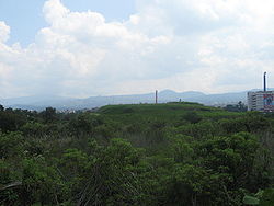
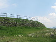
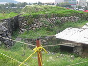
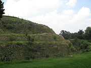
At the site are 8 of the many housing and religious buildings that once existed, and the remains of a hydraulic system that supplied water the city. One of the pyramids was built in a strategic position, representing early prehispanic attempts to link religious concepts with cosmic events through building construction.
The name
The etymology is unknown.According to INAH, Zelia Nuttall believes that Cuicuilco means: “Place where songs and dances are made””.
History
Cuicuilco was originally founded as a farming village, but presents evidence of early religious practices including stone offerings and the use of ceramic
Pottery
Pottery is the material from which the potteryware is made, of which major types include earthenware, stoneware and porcelain. The place where such wares are made is also called a pottery . Pottery also refers to the art or craft of the potter or the manufacture of pottery...
s as grave goods
Grave goods
Grave goods, in archaeology and anthropology, are the items buried along with the body.They are usually personal possessions, supplies to smooth the deceased's journey into the afterlife or offerings to the gods. Grave goods are a type of votive deposit...
. The city grew around a large ceremonial center with pyramids and an associated urban area
Urban area
An urban area is characterized by higher population density and vast human features in comparison to areas surrounding it. Urban areas may be cities, towns or conurbations, but the term is not commonly extended to rural settlements such as villages and hamlets.Urban areas are created and further...
that included plaza
Plaza
Plaza is a Spanish word related to "field" which describes an open urban public space, such as a city square. All through Spanish America, the plaza mayor of each center of administration held three closely related institutions: the cathedral, the cabildo or administrative center, which might be...
s and avenues bordering a series of small, shallow pools. These pools were fed by runoff from the nearby hills of Zacayuca and Zacaltepetl. Population at the city's peak is estimated at 20,000 people. Site features include terraces, various buildings, fortifications, and irrigation
Irrigation
Irrigation may be defined as the science of artificial application of water to the land or soil. It is used to assist in the growing of agricultural crops, maintenance of landscapes, and revegetation of disturbed soils in dry areas and during periods of inadequate rainfall...
ditches and canal
Canal
Canals are man-made channels for water. There are two types of canal:#Waterways: navigable transportation canals used for carrying ships and boats shipping goods and conveying people, further subdivided into two kinds:...
s.
Although this site produced a new ceramic tradition (around 600–200 BCE), it is considered that the overall site area was developed by several generations inhabiting the place.
Archaeological evidence, ceramic and structures, indicate that Cuicuilco developed during the first millennium BCE, during the Preclassical, as a small settlement, its inhabitants interacted with other sites, in the Mexico basin as well as relatively distant regions, e.g. Chupicuaro
Chupícuaro (archaeological site)
Chupícuaro is an important prehispanic archeological site from the late preclassical or formative period; located in the northern mesoamerican border, west of the Mexican Plateau, it is on hills nearby the Lerma River and its tributary Coroneo or Tiger River; currently most part is under water by...
to the West and Monte Albán
Monte Albán
Monte Albán is a large pre-Columbian archaeological site in the Santa Cruz Xoxocotlán Municipality in the southern Mexican state of Oaxaca...
Southeast.
Estimated Cuicuilco occupation periods, at best may be considered tentative. The earliest occupation is estimated in 1200 BCE, there were many farmers’ villages of similar configuration and space distribution. During the period 1000–800 BCE conical structures with oval base were built. The specialists call these sites regional capitals considering that had higher hierarchy and functioned as integration centers, eventually became larger regional capitals.
If the great pyramid of Cuicuilco is an expression of this increment, then this level of development was reached between 800–600 BC, when was built. If true, the proto-urban characteristics might have extended to the late Preclassical, the Cuicuilco weakening between 100 BCE and 1 CE. Time when development of Teotihuacan began, that became and important Classical period urban center.
Beginning of the Culture
In the mid-Preclassical (c. 800 BCE), settlements emerged in the area, which slowly evolved and grew, becoming villas, subsequently developing into a major civic-ceremonial urban centers in late preclassical (c. 100 CE). As an urban center, Cuicuilco became very important, with an advanced and hierarchized society.There are opinions that the development of place, from its foundation, was due to its strategic location near the Toluca entrance, and near the Texcoco lake shores.
Under this perspective, although the place produced (around 600–200 BCE) a new ceramic tradition, is also evident that the region was configured by successive generations.
Culture Growth
Towards the late preclassical (around 150 BCE), period Cuicuilco achieved the features of an urban regional center, with a population estimated at about 20,000 inhabitants, comparable with Teotihuacan at that time (cf. Sanders, 1981), Cuicuilco development was affected by the eruption of the Xitle volcano, forming a lava layer that partially or completely covered the city’s structures, whose extension is inferred to have reached nearly 400 hectares (cf. ibid.).Physiological characteristics of the culture
People had round heads affected by tubular cranial deformation direct or oblique, the first being more common. Dental mutilation was practiced. Average life span was 51 years, mainly affected by diseases like osteomyelitis.Agriculture and food
From their location, inhabitants had access to natural resources (flora and fauna), as they were located approximately 4 km from the Xochimilco Lake, and near the Sierra de las Cruces and Ajusco (cf. Sanders 1981: 173); In addition there were water springs and streams. Prehispanic groups managed to produce food. The economic mesoamerican base was centered on agriculture, probably supplemented with hunting, fishing and gathering; access to wood had to be simple, from nearby forests, and agricultural land in the vicinity of the nuclear portion of the site, buried today under meters of volcanic lava and modern buildings.It is believed that their diet consisted mostly of corn, beans, squash, tomatoes, fish and wild animals.
End of the culture
The decline began in the early 1st century BCE, with the increasing rise of Teotihuacán as a center of cultural and religious influence. By the year 400 CE, the Xitle volcano, located in the vicinity of “the AjuscoAjusco
Ajusco is a lava dome volcano located just south of Mexico City, Mexico, in the Tlalpan borough of the city. It is the highest point in the Mexican Federal District, which contains Mexico City.-Etymology:...
” (Nahuatl: atl, xochitl, co, “water”, “flower”, “place”; “place of flowers in water”), also known as Sierra del Ajusco - Chichinauhtzin, erupted burying and destroying what still remained Cuicuilco and Copilco (another important ceremonial center). This disaster led to cuicuilca culture dispersion towards Toluca and Teotihuacan, that hosted a large part of the cuicuilcas and incorporated many features of their culture.
It is considered that the Cuicuilco decline (100 BCE to 1 CE) had a minor recovery in 1–150 CE, by the presence of fire deities.
In spite of the Cuicuilco abandonment as an important ceremonial center, people continued making offerings when the site was covered by lave from the Xitle volcano, which happened around 400 CE.
From the beginning of the last century “El Pedregal” was an attractive place to define the predecessor cultures of the Teotihuacan y Mexica cultures in the México basin. Cuicuilco B investigations demonstrated that the site development was as a consequence of internal dynamics.
Archaeologists conclude that Cuicuilco was a prominent community prior to the emergence of Teotihuacan
Teotihuacan
Teotihuacan – also written Teotihuacán, with a Spanish orthographic accent on the last syllable – is an enormous archaeological site in the Basin of Mexico, just 30 miles northeast of Mexico City, containing some of the largest pyramidal structures built in the pre-Columbian Americas...
as an urban center, noting that the six small communities which some archeologists believe eventually combined to become Teotihuacan were founded and showing evidence of modest growth during the time Cuicuilco was building pyramids and public monuments. The city seems to have been abandoned around AD 150 to 200 after the eruption of a nearby volcano, Xitle
Xitle
Xitle is a volcano in the Ajusco range in Cumbres del Ajusco National Park. It is located in the Tlalpan borough in the southwestern part of Mexico City. It is an ash cone volcano with a conical form, round base, altitude of approximately 300m, and a slope between 30° and 40°.Xitle registered its...
, although the territory was reoccupied at a much later date. Pottery, and other evidence, suggests that refugees from the volcanic disaster migrated north and became part of the population pool of Teotihuacan, near the northern shore of the Lake Texcoco.
Archaeological site
Other Investigations
The prehispanic settlement and its surroundings, upon being covered by lava, were sealed and without ulterior alterations. Archaeological materials above the lava were affected differently during the last 2000 years.The lava flow sealed a body of water, constitutes sedimentation typical of Peat
Peat
Peat is an accumulation of partially decayed vegetation matter or histosol. Peat forms in wetland bogs, moors, muskegs, pocosins, mires, and peat swamp forests. Peat is harvested as an important source of fuel in certain parts of the world...
or turf, stagnant water in a marshy environment with a high degree of organic material preservation. The presence of ceramic and stone materials fragments suggests shore proximity.
In Peat can see evidence of several volcanic ash eruptions from the Xitle and perhaps, the Popocatépetl. At the western side of a sample probe, under a peat paleo-flow a sand stream was found, with pebbles and gravel, evidence of a steep slope and torrential waters.
Lava at the bottom of the Lake was covered by sedimentation, indicating that lava did not destroy the lacustrine environment and the water body continued after the eruption of the Xitle towards 200 CE.
During Byron Cummings (1922–1925) exploration, ceramic was found from phases preceding the eruption, this was followed by Eduardo Noguera (1939), who excavated burials in the proximity of the pyramidal sector known as Cuicuilco A, corresponding to the preclassical archaeological site. In 1957 Heiser and Bennyhoff investigations provided relevant information to refine the chronological sequence of the main building basement (cf. Schávelzon, 1983)
Between 1966 and 1968, important complexes of architectural structures were found as well as a series of conical formations, a group called Cuicuilco B, where more than 300,000 ceramic pots were rescued (Müller, 1990). Based on analysis of archaeological ceramics of Cuicuilco B, Florence Müller determined that the occupation of the settlement continued after the Xitle eruption, during the Classical, Epiclassical, postclassical periods until the spanish conquest, even though the importance of the site as well as the number of inhabitants dropped radically.
In 1990 in the sector known as Cuicuilco C, Rodríguez identified predominant preclassical ceramic materials, as well as, to a lesser extent, pots from later periods, including colonial and modern (Rodriguez, 1994).
Stratigraphy has determined that, after the Xitle eruption, materials were deposited on a layer of lava cushions associated with a body of water, which demonstrate the presence of settlements or villages from approximately 200 to 950 CE, according to the preliminary analysis of ceramic layer
Features of archaeological materials allow inferring the context of the natural and cultural training processes. Inhabitants discarded vases and fragments in the vicinity of the body of water, and many pots were trapped in the lava, especially domestic pieces such as pans, pots, pitchers, dishes, boxes and comales
Comal (cookware)
A comal is a smooth, flat griddle typically used in Mexico to cook tortillas, toast spices, sear meat, and generally prepare food. Similar cookware is called a budare in South America. Some comals are concave and made of "barro" . These are still made and used by the indigenous peoples of Mexico...
, even if it does not preclude the possibility that at the end of the life of these vessels, they were simply thrown into the water, considered as trash. On the other hand, the presence of braziers fragments, miniature pieces and Tlaloc vases indicates that these were thrown into the water as offerings as part of rites, similar situation to those recorded by spanish chroniclers as Sahagún (1989) and Duran (1967) in the twin cities of Tenochtitlan and Tlatelolco as well as in other settlements in late postclassical Mexico.
Many ceramic materials identified in the preliminary analysis, correspond to phases of Teotihuacán apogee during the classical period (Tlamimilolpa and Xolalpan phases), between 200 and 650 CE. According to recently adjusted chronology based on radiocarbon dating (cf. Rattray, 1991); predominant types are temporarily located in the epiclassical period, 650-950 CE, Coyotlatelco tradition (cf. Rattray, 1966), and are contemporaneous with the Tula Chico occupation (cf. Cobean, 1990), as well as other important settlements in the Valley of Mexico, as Cerro de la Estrella and Azcapotzalco (altepetl)
Azcapotzalco (altepetl)
Azcapotzalco was a pre-Columbian Nahua altepetl , capital of the Tepanec empire, in the Valley of Mexico, on the western shore of Lake Texcoco.The name Azcapotzalco means "at the anthill" in Nahuatl...
. There are also materials, although low percentages, whose production and consumption starts in the epiclassical (based recent research made in the Tula region) but have been associated with the Tula apogee, according to ethno historical sources and some radiocarbon dating, it is located chronologically between 950 and 1150 CE. (cf. Cobean, 1990)
These archaeological materials indicate strong social interaction between the Valley of Mexico and other regions under the hegemonic power of Teotihuacán, as well as the conformation of sociopolitical units after the decline of said Empire, also as evidence of socio-economic aspects associated with the emergence of the Toltec State.
It is a restricted area where deposits were affected by activities of the 20th century, fragments found of Aztec ceramics from the end of the late postclassical, materials of the colonial period (native and spaniards) as well as 19th century European fine earthenware. This material provide evidence of a settlement or village in Cuicuilco from the Tepaneca-Aztec
Aztec
The Aztec people were certain ethnic groups of central Mexico, particularly those groups who spoke the Nahuatl language and who dominated large parts of Mesoamerica in the 14th, 15th and 16th centuries, a period referred to as the late post-classic period in Mesoamerican chronology.Aztec is the...
empire, before the spaniards arrival, continuing the occupation of land owners such as Bernal Díaz del Castillo and other.
Current Situation
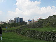
Due to its location, Cuicuilco is in a difficult situation. Modern planning and economic interests of the place. There disputes on conservation and legislation of the archaeological heritage.Known Cuicuilco is divided into two zones. The first is known as Cuicuilco A, where the ceremonial center is located. The other is called Cuicuilco B and lies West of Cuicuilco A, in the Olympic village Sports Centre.
Its importance is recognized by all historians and archaeologists, however has been barely studied, especially if compared with other archaeological sites, as Teotihuacan and Tula. The main investigation obstacle is that the area is covered almost entirely with a lava layer, of about 9 and 10 meters thick. This difficulty is compounded by urbanization area with constructions directly above of the archaeological site, as was the Telmex building and the Cuicuilco commercial Plaza in 1997.