
La Quemada
Encyclopedia
| Chalchihuites Culture – Archaeological Site | ||
| Name: | La Quemada | |
| Type | Mesoamerican archaeology | |
| Location | Villanueva Municipality, Zacatecas Zacatecas Zacatecas officially Estado Libre y Soberano de Zacatecas is one of the 31 states which, with the Federal District, comprise the 32 Federal Entities of Mexico. It is divided in 58 municipalities and its capital city is Zacatecas.... |
|
| Region | Mesoamerica Mesoamerica Mesoamerica is a region and culture area in the Americas, extending approximately from central Mexico to Belize, Guatemala, El Salvador, Honduras, Nicaragua, and Costa Rica, within which a number of pre-Columbian societies flourished before the Spanish colonization of the Americas in the 15th and... |
|
| Coordinates | 22°27′23"N 102°49′16"W | |
| Culture | Chalchihuites Chalchihuites Alta Vista, or Chalchihuites, is a small Mesoamerican archaeological site in the Mexican state of Zacatecas, in the northwest of Mexico. The archaeological site of Alta Vista, at Chalchihuites, is located 137 miles to the northwest of the city of Zacatecas and 102 miles southeast of the city of... |
|
| Language | ||
| Chronology | 300 to 1200 AD | |
| Period | Mesoamerican Classical, early Postclassical | |
| Apogee | ||
| INAH Web Page | La Quemada archaeological site | |
La Quemada is a Mesoamerican archeological site, also known (according to different versions) as Chicomóztoc. It is located in the Villanueva Municipality, in the state of Zacatecas
Zacatecas
Zacatecas officially Estado Libre y Soberano de Zacatecas is one of the 31 states which, with the Federal District, comprise the 32 Federal Entities of Mexico. It is divided in 58 municipalities and its capital city is Zacatecas....
, about 56 kilometers south of the city of Zacatecas
Zacatecas, Zacatecas
Zacatecas is a city and municipality in Mexico and the capital of the state of Zacatecas. It is located in the north central part of the country. The city had its start as a Spanish mining camp in the mid 16th century. Prior to this, the area's rich deposits in silver and other minerals were known...
on Federal Highway 54 Zacatecas–Guadalajara
Guadalajara, Jalisco
Guadalajara is the capital of the Mexican state of Jalisco, and the seat of the municipality of Guadalajara. The city is located in the central region of Jalisco in the western-pacific area of Mexico. With a population of 1,564,514 it is Mexico's second most populous municipality...
, in Mexico.
History
Given the distance between La Quemada and the center of Mesoamerica, this archeological zone has been subject of different interpretations on the part of historians and archeologists, who have attempted to associate it with different cultures.It is supposed that this place could be the legendary Chicomostoc, a Caxcan
Caxcan
The Caxcan were a partly nomadic indigenous people of Mexico. Under their leader, Francisco Tenamaztle, the Caxcan were allied with the Zacatecos against the Spaniards during the Mixtón Rebellion. During the rebellion, they were described as "the heart and the center of the Indian Rebellion". They...
site, a Teotihuacán
Teotihuacán
Teotihuacan – also written Teotihuacán, with a Spanish orthographic accent on the last syllable – is an enormous archaeological site in the Basin of Mexico, just 30 miles northeast of Mexico City, containing some of the largest pyramidal structures built in the pre-Columbian Americas...
fortress, a Tarascan center, a fort against Chichimeca
Chichimeca
Chichimeca was the name that the Nahua peoples of Mexico generically applied to a wide range of semi-nomadic peoples who inhabited the north of modern-day Mexico and southwestern United States, and carried the same sense as the European term "barbarian"...
intruders, a Toltec
Toltec
The Toltec culture is an archaeological Mesoamerican culture that dominated a state centered in Tula, Hidalgo in the early post-classic period of Mesoamerican chronology...
trading post, or simply consequence of independent development and a city of all the native groups established north of the Río Grande de Santiago
Río Grande de Santiago
The Río Grande de Santiago is one of the longest rivers in Mexico, measuring up long. The river begins at Lake Chapala and continues roughly north-west through the Sierra Madre Occidental, receiving the Verde, Juchipila, Bolaños, and other tributaries...
.
In 1615, Fray Juan de Torquemada
Fray Juan de Torquemada
Juan de Torquemada was a Franciscan friar, missionary and historian in Spanish colonial Mexico. He is most famous for his 1615 monumental history of the Indigenous entitled Los veinte y un libros rituales y Monarchia Indiana, commonly known as simply Monarchia Indiana...
identified La Quemada as one of the places visited by the Aztecs during their migration from the north to the Mexico central plateau, and where older people and children were left behind. Francisco Javier Clavijero
Francisco Javier Clavijero
Francisco Javier Clavijero Echegaray , was a Novohispano Jesuit teacher, scholar and historian...
, in 1780, associated this site with Chicomoztoc, where the Aztecs remained for nine years during their voyage to Anahuac
Anahuac
Anahuac is an ancient name for a Mesoamerican, particularly Aztec, area or areas, usually identified as located within or even coterminous with the Valley of Mexico...
.
This speculation originated the belief La Quemada is the mythical place called "The Seven Caves". Archeological investigations since the 1980s determined that La Quemada developed between 300 and 1200 AD (Classical and early Postclassical periods) and that it was contemporaneous of the Chalchihuites
Altavista (Zacatecas)
Alta Vista, o Chalchihuites, is a mesoamerican archaeological site near the municipality of Chalchihuites in the Mexican state of Zacatecas, in the northwest of Mexico...
culture, characterized from the first century of our era, by intense mining activity. La Quemada, Las Ventanas El Ixtepete, major settlements in the “Altos de Jalisco
Jalisco
Jalisco officially Estado Libre y Soberano de Jalisco is one of the 31 states which, with the Federal District, comprise the 32 Federal Entities of Mexico. It is located in Western Mexico and divided in 125 municipalities and its capital city is Guadalajara.It is one of the more important states...
”, and northern Guanajuato
Guanajuato
Guanajuato officially Estado Libre y Soberano de Guanajuato is one of the 31 states which, with the Federal District, comprise the 32 Federal Entities of Mexico. It is divided in 46 municipalities and its capital city is Guanajuato....
, formed a trade network linked to Teotihuacán
Teotihuacán
Teotihuacan – also written Teotihuacán, with a Spanish orthographic accent on the last syllable – is an enormous archaeological site in the Basin of Mexico, just 30 miles northeast of Mexico City, containing some of the largest pyramidal structures built in the pre-Columbian Americas...
(350-700 AD), that extended from northern Zacatecas to the Valley of Mexico.
It is possible that links established by Teotihuacán were with local rulers of ceremonial centers, of the mentioned network, or through alliances with regional intermediaries, or by small Teotihuacán merchants groups, living in these centers, that ensured the various products flow, such as minerals, salt, shells, quill
Quill
A quill pen is a writing implement made from a flight feather of a large bird. Quills were used for writing with ink before the invention of the dip pen, metal-nibbed pens, the fountain pen, and, eventually, the ballpoint pen...
s, obsidian, and peyote
Peyote
Lophophora williamsii , better known by its common name Peyote , is a small, spineless cactus with psychoactive alkaloids, particularly mescaline.It is native to southwestern Texas and Mexico...
, among others.
Between 700 and 1100 AD, La Quemada did not participate as a network member, but as the dominant trade location at the regional level, it began to compete with other neighboring sites. It was during this time that the site acquired a defensive character, evidence of which is the construction, on the north flank of the site, of a wall approximately four meters high by four meters wide, as well as the elimination of two stairways in the complex with the intention of restricting internal circulation.
From the evidence of fire in several parts of the site, a violent decline of the settlement is inferred. It is this apparent destruction by fire which gives the site its name of la (ciudad) quemada, "the burnt city".
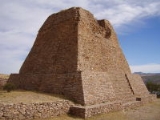
The site
La Quemada is made up of numerous different size masonryMasonry
Masonry is the building of structures from individual units laid in and bound together by mortar; the term masonry can also refer to the units themselves. The common materials of masonry construction are brick, stone, marble, granite, travertine, limestone; concrete block, glass block, stucco, and...
platforms built onto the hill, these were foundations for structures built over them. On the south and southeastern sides is a high concentration of ceremonial constructions, some of which are complexes made up of sunken patio platforms and altar-pyramid, a typical Mesoamerican architectonic attribute.
On the west side is a series of platforms or terraces, apparently more residential structures than ceremonial. All architectonic elements of La Quemada were constructed with rhyolite
Rhyolite
This page is about a volcanic rock. For the ghost town see Rhyolite, Nevada, and for the satellite system, see Rhyolite/Aquacade.Rhyolite is an igneous, volcanic rock, of felsic composition . It may have any texture from glassy to aphanitic to porphyritic...
(volcanic effusive rock of the granite family) slabs, extracted from the hill located northeast of the Votive Pyramid.
To build the structures and join the slabs a clay and vegetal fiber mortar
Mortar (masonry)
Mortar is a workable paste used to bind construction blocks together and fill the gaps between them. The blocks may be stone, brick, cinder blocks, etc. Mortar becomes hard when it sets, resulting in a rigid aggregate structure. Modern mortars are typically made from a mixture of sand, a binder...
was used, as it degrades and erodes
Erosion
Erosion is when materials are removed from the surface and changed into something else. It only works by hydraulic actions and transport of solids in the natural environment, and leads to the deposition of these materials elsewhere...
in time, it caused wall deterioration. Over the masonry walls several clay stucco layers were applied, currently only a few samples of original finishing remain.
Studies made to date, provide basis to determine that the monumental complex was constructed at different times. It is known that the structures built were constructed over previous constructions, which were covered by later constructive stages.
If the total elements of this site are considered, from the extensive roads and the numerous smaller sites linked to La Quemada, this is a singular archaeological site in the context of mesoamerican sites.
Structures
