

Balsas River
Encyclopedia
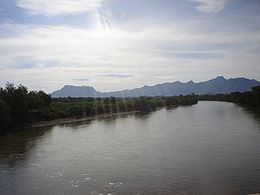
The Balsas River is a major river of south-central Mexico
. The basin flows through the states of Puebla, Morelos, Guerrero, and Mexico. The river empties into the Pacific Ocean
at Mangrove Point, adjacent to the city of Lázaro Cárdenas, Michoacán
. Several rapid
s along the course of the Balsas River limit its navigability and thus the river has been largely used for generation of hydroelectric power, flood control and irrigation
.
s. Their culture originated at the Alto Balsas region in the Balsas River valley in Guerrero; it had dominated the region and is said to be the root of the Mesoamerican culture. However, nowadays it can only be traced to the archeological findings at Teopantecuanitlan
in Capallio municipality, and is not maintained by the present population of Nahua. Teopantecuanitlan is located within the Balsas River basin and is claimed to be over 3500 years old. Though it is known that successive communities of Yop, Coixica, Matlatzinca (Chontal), Tlahuica and Xochimilca with Nahua succeeding in the end have lived in the region, archeological excavations in the area are yet to establish the hierarchical succession of the various communities. During the period of 1100–480 BC, the region between the lower Balsas river valley and the Lerma-Santiago River fell under control of the Tarascan Empire.
According to the 1980 Census, 47,000 people lived along the Balsas river banks, spread over 37 communities, within the six municipalities of the region. Nahua peoples constite 47% of the population, 15% are indigenous people (speaking four different languages), other large communities are Mixtec
(23%) and Tlapenc (19%), and the balance 4% are Amuzgo
. The population increased to 60,000 in the 1990s. The communities, while retaining their individualities, show close linguistic, kinship, and cultural relationships revealed, for example, when the perform the rituals of patronal feasts.
 The upper Balsas River basin includes the State of Puebla, the States of Mexico, Morelos, and the Guerrero Mountain Zone, as well as several river systems of the Mesa Central
plateau. The main system is of the Tlapanec River, with tributaries originating in the mountains such as the Oaxaca Mixteca. It is joined by the Amacuzac River fed by streams around Xonacantapec volcano and by the San Jeronimo
and Chontalcoatlan rivers. The last two rivers originate around Popocatepetl
volcano and flow through the State of Morelos.
With a length of some 771 kilometres (479 mi) the Balsas River is one of Mexico's longest rivers. It originates at the confluence of the San Martin
and Zahuapan River
s as Atoyac River in the state of Puebla
. From here it flows south-west and then westward, into a depression through the state of Guerrero
, and discharges into the Pacific Ocean at 17°56′24"N 102°08′16"W.
The climate of the basin varies from temperate to subtropical with mean annual temperatures between 12.5 and 28 °C. Rainfall in the basin is highly seasonal and some 90% of annual precipitation occurs between May and September, with 546 mm recorded in the arid areas of the valley and 1000–1600 mm further upstream in the highland lakes area.
River Basin Councils
Water management has received due attention of the Government of Mexico over the past several decades. It included more efficient water use and aimed to meet water supply needs of the major cities in Mexico. The Tepalcatepec Commission was established in 1947 under the Ministry of Water Resources (one of the three commissions established initially) for the Balsas River development. In 1960, it was subordinated to the Balsas River Commission. Its tasks included planning, design, coordination and implementation of irrigation projects, flood control and hydropower generation, covering rural and urban development and health and communications aspects. Following the enactment of a new Water Law in the country, a Master Plan was developed in 1975 covering 13 hydrological regions (102 subregions). River Basin Councils were established, and 25 are currently in position out of the 26 planned.
The Balsas River has a discharge of 15–17 m3/s during the lean flow season. The steep slope of the river in a stretch of 30 km creates an elevation difference of 1200 m, providing excellent opportunities for hydropower development. Initially, 120 MW of power was generated at the power station at La Villita. This 336 MW station was built in the state of Michoacan, near the Pacific Coast. Another Balsas River project planned was the El Infiernillo; it became operational in 1964 and has an installed capacity of 1,120 MW. El Infiernillo Dam
is a 149 m rockfill embankment dam.
Agriculture
Agriculture in the basin has a rich history of over 9000 years, with an impressive transformation from the stage of unwelcome grass to high-yield maize fields. The valley is therefore known as the cradle of the "maize revolution" in the region.
Irrigation and hydroelectric power generation
Two dams on the river provide for irrigation and power generation. The water stored by the dam built above Tierra Caliente is utilized for growth of cotton and rice. The Balsas River basin was first considered for hydropower development in the 1940s. The basin has an area of 105,900 km2, and the two projects implemented here are the La Villita and El Infiernello (both in Michoecin).
The El Infiernillo Dam is a 149 m rock fill embankment dam with a narrow central core. It is located on the Balsas River about 200 miles (321.9 km) southwest of Mexico City. Its height is about 148 m, crest length is 344 m, and the base width from the upstream toe to the downstream toe is 570 m. The reservoir has a storage capacity of 7,090 million m3. This is the largest hydropower project in Mexico which is also expected to reduce the floods in the area.
La-Villita is an earth-cum-rock fill dam with a crest length of 320 m, a height of 60 m, and a power generation capacity of 300 MW. This was the first dam built on the Balsas River. It is located 15 km from the Pacific Ocean.
Both dams have a solid structure and withstood well the five earthquakes of the magnitude up to 8.1 which occurred after their construction.
Transbasin water transfer
A project has been implemented to redirect some water from the Balsas River basin to the Lerma River Basin and the Valley of Mexico. It aimed to meet the growing drinking water needs of the Mexico City, which is about 130 km from the basin. Such transfers are expected to create water-sharing disputes among the basin states in the future.
Navigational studies
The navigation of this river by shallow–draft steamers was initially promoted for the development of the Guerrero area, and in 1911 a new concession was given by the Government of Mexico for this purpose. The proposal was to use the river for passengers and freight from the point of crossing of the Acapulco Trail to the Pacific Ocean, over the river length of about 300 miles. Initially a 25 foot boat was commissioned at Balsas railroad bridge station by Gullermo Niven, a business man in Mexico City
who set out to establish its feasibility in November/December 1911. He had carried recommendation letters from President Medero of Mexico to important persons in towns and villages on the way. On this exploration he was accompanied by 11 people, including two river navigation experts and Fred Macfarlene, a California financier. The exploration lasted 22 days from the time of its departure till the return of the team back to Mexico City via Manzanillo on the steamboat
S.S. Ramón Corral
which picked the exploration party at the last point of their journey at Orilla. During this period many events happened en-route due to rebel activities, but the navigation itself was fairly smooth except for an encounter with a rock outcrop in the middle of a narrow section of the river where the boat had overturned, injuring two people. While the river was proven navigable, investments to develop the facilities did not happen immediately due to the rebel activities in the area.
s, often depicting flowers and wildlife.
Mexico
The United Mexican States , commonly known as Mexico , is a federal constitutional republic in North America. It is bordered on the north by the United States; on the south and west by the Pacific Ocean; on the southeast by Guatemala, Belize, and the Caribbean Sea; and on the east by the Gulf of...
. The basin flows through the states of Puebla, Morelos, Guerrero, and Mexico. The river empties into the Pacific Ocean
Pacific Ocean
The Pacific Ocean is the largest of the Earth's oceanic divisions. It extends from the Arctic in the north to the Southern Ocean in the south, bounded by Asia and Australia in the west, and the Americas in the east.At 165.2 million square kilometres in area, this largest division of the World...
at Mangrove Point, adjacent to the city of Lázaro Cárdenas, Michoacán
Lázaro Cárdenas, Michoacán
Lázaro Cárdenas is a port city that with its surrounding municipality is located in the southern part of the Mexican state of Michoacán. It was formerly known as Los Llanitos, but changed its name as a tribute to Lázaro Cárdenas del Río, a Michoacán-born politician who was president of Mexico from...
. Several rapid
Rapid
A rapid is a section of a river where the river bed has a relatively steep gradient causing an increase in water velocity and turbulence. A rapid is a hydrological feature between a run and a cascade. A rapid is characterised by the river becoming shallower and having some rocks exposed above the...
s along the course of the Balsas River limit its navigability and thus the river has been largely used for generation of hydroelectric power, flood control and irrigation
Irrigation
Irrigation may be defined as the science of artificial application of water to the land or soil. It is used to assist in the growing of agricultural crops, maintenance of landscapes, and revegetation of disturbed soils in dry areas and during periods of inadequate rainfall...
.
History
The Balsas River valley was possibly one of the earliest maize growing sites in Mexico, dating from around 9200 years ago. Later the area was populated by the OlmecOlmec
The Olmec were the first major Pre-Columbian civilization in Mexico. They lived in the tropical lowlands of south-central Mexico, in the modern-day states of Veracruz and Tabasco....
s. Their culture originated at the Alto Balsas region in the Balsas River valley in Guerrero; it had dominated the region and is said to be the root of the Mesoamerican culture. However, nowadays it can only be traced to the archeological findings at Teopantecuanitlan
Teopantecuanitlan
Teopantecuanitlan is an archaeological site in the Mexican state of Guerrero that represents an unexpectedly early development of complex society for the region. The site dates to the Early to Middle Formative Periods, and archaeological evidence clearly indicates some kind of connection existed...
in Capallio municipality, and is not maintained by the present population of Nahua. Teopantecuanitlan is located within the Balsas River basin and is claimed to be over 3500 years old. Though it is known that successive communities of Yop, Coixica, Matlatzinca (Chontal), Tlahuica and Xochimilca with Nahua succeeding in the end have lived in the region, archeological excavations in the area are yet to establish the hierarchical succession of the various communities. During the period of 1100–480 BC, the region between the lower Balsas river valley and the Lerma-Santiago River fell under control of the Tarascan Empire.
According to the 1980 Census, 47,000 people lived along the Balsas river banks, spread over 37 communities, within the six municipalities of the region. Nahua peoples constite 47% of the population, 15% are indigenous people (speaking four different languages), other large communities are Mixtec
Mixtec
The Mixtec are indigenous Mesoamerican peoples inhabiting the Mexican states of Oaxaca, Guerrero and Puebla in a region known as La Mixteca. The Mixtecan languages form an important branch of the Otomanguean language family....
(23%) and Tlapenc (19%), and the balance 4% are Amuzgo
Amuzgo
Amuzgo is an Oto-Manguean language spoken in the Costa Chica region of the Mexican states of Guerrero and Oaxaca by about 44,000 speakers. Like other Oto-Manguean languages, Amuzgo is a tonal language. From syntactical point of view Amuzgo can be considered as an active language...
. The population increased to 60,000 in the 1990s. The communities, while retaining their individualities, show close linguistic, kinship, and cultural relationships revealed, for example, when the perform the rituals of patronal feasts.
Geography and climate
Mexican Plateau
The Central Mexican Plateau, also known as the Mexican Altiplano or Altiplanicie Mexicana, is a large arid-to-semiarid plateau that occupies much of northern and central Mexico...
plateau. The main system is of the Tlapanec River, with tributaries originating in the mountains such as the Oaxaca Mixteca. It is joined by the Amacuzac River fed by streams around Xonacantapec volcano and by the San Jeronimo
San Jeronimo River
The San Jeronimo is a river in Southern Mexico. When Hurricane Boris made landfall there in July 1996, it caused flooding that made 5000 homeless....
and Chontalcoatlan rivers. The last two rivers originate around Popocatepetl
Popocatépetl
Popocatépetl also known as "Popochowa" by the local population is an active volcano and, at , the second highest peak in Mexico after the Pico de Orizaba...
volcano and flow through the State of Morelos.
With a length of some 771 kilometres (479 mi) the Balsas River is one of Mexico's longest rivers. It originates at the confluence of the San Martin
San Martín River
-References:*Atlas of Mexico, 1975 .*The Prentice Hall American World Atlas, 1984.*Rand McNally, The New International Atlas, 1993....
and Zahuapan River
Zahuapan River
-References:*Atlas of Mexico, 1975 .*The Prentice Hall American World Atlas, 1984.*Rand McNally, The New International Atlas, 1993....
s as Atoyac River in the state of Puebla
Puebla
Puebla officially Estado Libre y Soberano de Puebla is one of the 31 states which, with the Federal District, comprise the 32 Federal Entities of Mexico. It is divided in 217 municipalities and its capital city is Puebla....
. From here it flows south-west and then westward, into a depression through the state of Guerrero
Guerrero
Guerrero officially Estado Libre y Soberano de Guerrero is one of the 31 states which, with the Federal District, comprise the 32 Federal Entities of Mexico. It is divided in 81 municipalities and its capital city is Chilpancingo....
, and discharges into the Pacific Ocean at 17°56′24"N 102°08′16"W.
The climate of the basin varies from temperate to subtropical with mean annual temperatures between 12.5 and 28 °C. Rainfall in the basin is highly seasonal and some 90% of annual precipitation occurs between May and September, with 546 mm recorded in the arid areas of the valley and 1000–1600 mm further upstream in the highland lakes area.
River basin development
The Balsas River basin has witnessed much economic development. Through building dams these activities aimed at irrigation, generation of electricity, and improving agriculture and living conditions of indigenous people, mainly the Nahuas who form the majority group. Seven hydropower projects are envisaged on the Balsas River. The two major projects are the La Villita and El Infiernello (in Michoecin). The Carlos Ramirez Ulloa (El Caracol) project is being developed in the Guerrero and four others are planned for the future.River Basin Councils
Water management has received due attention of the Government of Mexico over the past several decades. It included more efficient water use and aimed to meet water supply needs of the major cities in Mexico. The Tepalcatepec Commission was established in 1947 under the Ministry of Water Resources (one of the three commissions established initially) for the Balsas River development. In 1960, it was subordinated to the Balsas River Commission. Its tasks included planning, design, coordination and implementation of irrigation projects, flood control and hydropower generation, covering rural and urban development and health and communications aspects. Following the enactment of a new Water Law in the country, a Master Plan was developed in 1975 covering 13 hydrological regions (102 subregions). River Basin Councils were established, and 25 are currently in position out of the 26 planned.
The Balsas River has a discharge of 15–17 m3/s during the lean flow season. The steep slope of the river in a stretch of 30 km creates an elevation difference of 1200 m, providing excellent opportunities for hydropower development. Initially, 120 MW of power was generated at the power station at La Villita. This 336 MW station was built in the state of Michoacan, near the Pacific Coast. Another Balsas River project planned was the El Infiernillo; it became operational in 1964 and has an installed capacity of 1,120 MW. El Infiernillo Dam
Infiernillo Dam
The Infiernillo Dam , also known as Adolfo Lopez Mateos Dam, is an embankment dam on the Balsas River near La Unión, Guerrero, Mexico. The dam supports a hydroelectric power station containing six turbine-generators for a total installed capacity of 1,120 MW. The dam is high, long and is owned by...
is a 149 m rockfill embankment dam.
Agriculture
Agriculture in the basin has a rich history of over 9000 years, with an impressive transformation from the stage of unwelcome grass to high-yield maize fields. The valley is therefore known as the cradle of the "maize revolution" in the region.
Irrigation and hydroelectric power generation
Two dams on the river provide for irrigation and power generation. The water stored by the dam built above Tierra Caliente is utilized for growth of cotton and rice. The Balsas River basin was first considered for hydropower development in the 1940s. The basin has an area of 105,900 km2, and the two projects implemented here are the La Villita and El Infiernello (both in Michoecin).
The El Infiernillo Dam is a 149 m rock fill embankment dam with a narrow central core. It is located on the Balsas River about 200 miles (321.9 km) southwest of Mexico City. Its height is about 148 m, crest length is 344 m, and the base width from the upstream toe to the downstream toe is 570 m. The reservoir has a storage capacity of 7,090 million m3. This is the largest hydropower project in Mexico which is also expected to reduce the floods in the area.
La-Villita is an earth-cum-rock fill dam with a crest length of 320 m, a height of 60 m, and a power generation capacity of 300 MW. This was the first dam built on the Balsas River. It is located 15 km from the Pacific Ocean.
Both dams have a solid structure and withstood well the five earthquakes of the magnitude up to 8.1 which occurred after their construction.
Transbasin water transfer
A project has been implemented to redirect some water from the Balsas River basin to the Lerma River Basin and the Valley of Mexico. It aimed to meet the growing drinking water needs of the Mexico City, which is about 130 km from the basin. Such transfers are expected to create water-sharing disputes among the basin states in the future.
Navigational studies
The navigation of this river by shallow–draft steamers was initially promoted for the development of the Guerrero area, and in 1911 a new concession was given by the Government of Mexico for this purpose. The proposal was to use the river for passengers and freight from the point of crossing of the Acapulco Trail to the Pacific Ocean, over the river length of about 300 miles. Initially a 25 foot boat was commissioned at Balsas railroad bridge station by Gullermo Niven, a business man in Mexico City
Mexico City
Mexico City is the Federal District , capital of Mexico and seat of the federal powers of the Mexican Union. It is a federal entity within Mexico which is not part of any one of the 31 Mexican states but belongs to the federation as a whole...
who set out to establish its feasibility in November/December 1911. He had carried recommendation letters from President Medero of Mexico to important persons in towns and villages on the way. On this exploration he was accompanied by 11 people, including two river navigation experts and Fred Macfarlene, a California financier. The exploration lasted 22 days from the time of its departure till the return of the team back to Mexico City via Manzanillo on the steamboat
Steamboat
A steamboat or steamship, sometimes called a steamer, is a ship in which the primary method of propulsion is steam power, typically driving propellers or paddlewheels...
S.S. Ramón Corral
Ramón Corral
Ramón Corral was the Vice President of Mexico under Porfirio Díaz from 1904 until their deposition in 1911.-Early Years:...
which picked the exploration party at the last point of their journey at Orilla. During this period many events happened en-route due to rebel activities, but the navigation itself was fairly smooth except for an encounter with a rock outcrop in the middle of a narrow section of the river where the boat had overturned, injuring two people. While the river was proven navigable, investments to develop the facilities did not happen immediately due to the rebel activities in the area.
Arts and crafts
During the Tarascan period, the people of the valley created many items of red-slipped buff-colored pottery, painted in white, cream or red and made many ceramic pipes and tools using bronze alloys. The Mexican Indians inhabiting the Balsas river valley are noted for their bark paintingBark painting
Bark painting is an Australian Aboriginal art form, involving painting on the interior of a strip of tree bark. This is a continuing form of artistic expression in Arnhem Land and other regions in the Top End of Australia including parts of the Kimberley region of Western Australia...
s, often depicting flowers and wildlife.