

Cape (geography)
Encyclopedia
Headland
A headland is a point of land, usually high and often with a sheer drop, that extends out into a body of water.Headland can also refer to:*Headlands and bays*headLand, an Australian television series...
is a point or body of land extending into a body of water, usually the sea.
A cape usually represents a marked change in trend of the coastline. Their proximity to the coastline makes them prone to natural forms of erosion, mainly tidal actions. This results in capes having a relatively short geologic lifespan. Capes can be formed by glaciers, volcanoes, and changes in sea level. Erosion plays a large role in each of these methods of formation.
List of some well-known capes
- AfricaAfricaAfrica is the world's second largest and second most populous continent, after Asia. At about 30.2 million km² including adjacent islands, it covers 6% of the Earth's total surface area and 20.4% of the total land area...
- Cape of Good HopeCape of Good HopeThe Cape of Good Hope is a rocky headland on the Atlantic coast of the Cape Peninsula, South Africa.There is a misconception that the Cape of Good Hope is the southern tip of Africa, because it was once believed to be the dividing point between the Atlantic and Indian Oceans. In fact, the...
and Cape AgulhasCape AgulhasCape Agulhas is a rocky headland in the Western Cape, South Africa. It is the geographic southern tip of Africa and the official dividing point between the Atlantic and Indian oceans...
in South AfricaSouth AfricaThe Republic of South Africa is a country in southern Africa. Located at the southern tip of Africa, it is divided into nine provinces, with of coastline on the Atlantic and Indian oceans... - Cape JubyCape JubyCape Juby is a cape on the coast of southern Morocco, near the border with Western Sahara, directly east of the Canary Islands.Its surrounding area, called Cape Juby strip or Tarfaya strip, while making up presently the far South of Morocco, is in a way a semi-desertic buffer zone between Morocco...
in MoroccoMoroccoMorocco , officially the Kingdom of Morocco , is a country located in North Africa. It has a population of more than 32 million and an area of 710,850 km², and also primarily administers the disputed region of the Western Sahara... - Cape GuardafuiCape GuardafuiCape Guardafui , also known as Ras Asir and historically as Aromata promontorium, is a headland in the northeastern Bari province of Somalia. Located in the autonomous Puntland region, it forms the geographical apex of the region commonly referred to as the Horn of Africa.-Location:Cape Guardafui...
in SomaliaSomaliaSomalia , officially the Somali Republic and formerly known as the Somali Democratic Republic under Socialist rule, is a country located in the Horn of Africa. Since the outbreak of the Somali Civil War in 1991 there has been no central government control over most of the country's territory... - Cap-VertCap-VertCap-Vert is a peninsula in Senegal, and the westernmost point of the continent of Africa and of the Old World mainland. Originally called Cabo Verde or "Cape Green" by Portuguese explorers, it is not to be confused with the Cape Verde islands, which are some further west...
in SenegalSenegalSenegal , officially the Republic of Senegal , is a country in western Africa. It owes its name to the Sénégal River that borders it to the east and north... - Cape Blanc in MauritaniaMauritaniaMauritania is a country in the Maghreb and West Africa. It is bordered by the Atlantic Ocean in the west, by Western Sahara in the north, by Algeria in the northeast, by Mali in the east and southeast, and by Senegal in the southwest...
- Ras KasarRas KasarRas Kasar is a cape in northeastern Africa, on border between Eritrea and Sudan at the Red Sea. It is the northernmost point in Eritrea and the easternmost point in Sudan....
on the EritreaEritreaEritrea , officially the State of Eritrea, is a country in the Horn of Africa. Eritrea derives it's name from the Greek word Erethria, meaning 'red land'. The capital is Asmara. It is bordered by Sudan in the west, Ethiopia in the south, and Djibouti in the southeast...
–SudanSudanSudan , officially the Republic of the Sudan , is a country in North Africa, sometimes considered part of the Middle East politically. It is bordered by Egypt to the north, the Red Sea to the northeast, Eritrea and Ethiopia to the east, South Sudan to the south, the Central African Republic to the...
border
- Cape of Good Hope
- EuropeEuropeEurope is, by convention, one of the world's seven continents. Comprising the westernmost peninsula of Eurasia, Europe is generally 'divided' from Asia to its east by the watershed divides of the Ural and Caucasus Mountains, the Ural River, the Caspian and Black Seas, and the waterways connecting...
- Cape of GjuhëzCape of GjuhëzThe Cape of Gjuhëz is a rocky cape northwest of Karaburun Peninsula as well as the westernmost point of continental Albania. It projects into the sea in the form of the tongue, thus the origin of its name. The altitudes of the cape slope gradually towards the water, whereas the southern shores...
in Karaburun Peninsula, AlbaniaKaraburun Peninsula, AlbaniaKaraburun Peninsula, Albania is the largest peninsula of Albania, located in the District of Vlorë, southwestern Albania, at the eastern side of the Strait of Otranto, where the Adriatic Sea meets the Ionian Sea. It has an area of and has no population. It is long with a width that varies from... - Cape of RodonCape of RodonThe Cape of Rodon or Cape of Skanderbeg is a rocky cape on the Adriatic Sea north of Durrës. On the Cape is the Rodoni Castle, built by Skanderbeg in 1463. and a Saint Anthony Church.-References:...
in central AlbaniaAlbaniaAlbania , officially known as the Republic of Albania , is a country in Southeastern Europe, in the Balkans region. It is bordered by Montenegro to the northwest, Kosovo to the northeast, the Republic of Macedonia to the east and Greece to the south and southeast. It has a coast on the Adriatic Sea... - Cabo da RocaCabo da RocaCabo da Roca is a cape which forms the westernmost extent of mainland Portugal and continental Europe...
in PortugalPortugalPortugal , officially the Portuguese Republic is a country situated in southwestern Europe on the Iberian Peninsula. Portugal is the westernmost country of Europe, and is bordered by the Atlantic Ocean to the West and South and by Spain to the North and East. The Atlantic archipelagos of the...
(Western tip of mainland Europe) - Cabo de São Vicente / SagresSagresSagres Point , is a windswept shelf-like promontory located in the southwest Algarve region of southern Portugal. Only 4 km to the west and 3 km to the north lies Cape St. Vincent which is usually taken as the southwesternmost tip of Europe. The vicinity of Sagres Point and Cape St...
in PortugalPortugalPortugal , officially the Portuguese Republic is a country situated in southwestern Europe on the Iberian Peninsula. Portugal is the westernmost country of Europe, and is bordered by the Atlantic Ocean to the West and South and by Spain to the North and East. The Atlantic archipelagos of the...
(Southwestern tip of mainland Europe) - Cape ArkonaCape ArkonaCape Arkona is a cape on the island of Rügen in Mecklenburg-Vorpommern, Germany. Cape Arkona is the tip of the Wittow peninsula, just a few kilometres north of the Jasmund National Park....
in GermanyGermanyGermany , officially the Federal Republic of Germany , is a federal parliamentary republic in Europe. The country consists of 16 states while the capital and largest city is Berlin. Germany covers an area of 357,021 km2 and has a largely temperate seasonal climate... - Cape FinisterreCape Finisterreright|thumb|300px|Position of Cape Finisterre on the [[Iberian Peninsula]]Cape Finisterre is a rock-bound peninsula on the west coast of Galicia, Spain....
in SpainSpainSpain , officially the Kingdom of Spain languages]] under the European Charter for Regional or Minority Languages. In each of these, Spain's official name is as follows:;;;;;;), is a country and member state of the European Union located in southwestern Europe on the Iberian Peninsula... - North CapeNorth Cape, NorwayNorth Cape is a cape on the island of Magerøya in Northern Norway, in the municipality of Nordkapp. Its 307 m high, steep cliff is often referred to as the northernmost point of Europe, located at , 2102.3 km from the North Pole. However, the neighbouring point Knivskjellodden is actually...
in NorwayNorwayNorway , officially the Kingdom of Norway, is a Nordic unitary constitutional monarchy whose territory comprises the western portion of the Scandinavian Peninsula, Jan Mayen, and the Arctic archipelago of Svalbard and Bouvet Island. Norway has a total area of and a population of about 4.9 million...
(Northern tip of mainland Europe) - Cape WrathCape WrathCape Wrath is a cape in Sutherland, Highland, in northern Scotland. It is the most northwesterly point on the island of Great Britain. The land between the Kyle of Durness and the lighthouse that is situated right at the tip, is known as the Parph, two hundred and seven square kilometers of...
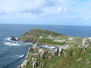
in ScotlandScotlandScotland is a country that is part of the United Kingdom. Occupying the northern third of the island of Great Britain, it shares a border with England to the south and is bounded by the North Sea to the east, the Atlantic Ocean to the north and west, and the North Channel and Irish Sea to the... - Cape CornwallCape CornwallCape Cornwall is a small headland in Cornwall, UK. It is four miles north of Land's End near the town of St Just. A cape is the point of land where two bodies of water meet and until the first Ordnance Survey, 200 years ago, it was thought that Cape Cornwall was the most westerly point in...
in CornwallCornwallCornwall is a unitary authority and ceremonial county of England, within the United Kingdom. It is bordered to the north and west by the Celtic Sea, to the south by the English Channel, and to the east by the county of Devon, over the River Tamar. Cornwall has a population of , and covers an area of... - Cap Gris NezCap Gris NezCap Gris Nez is a cape on the Côte d'Opale in the Pas-de-Calais département in northern France....
in FranceFranceThe French Republic , The French Republic , The French Republic , (commonly known as France , is a unitary semi-presidential republic in Western Europe with several overseas territories and islands located on other continents and in the Indian, Pacific, and Atlantic oceans. Metropolitan France... - Pointe du RazPointe du RazThe Pointe du Raz is a promontory that extends into the Atlantic from western Brittany, in France. The local Breton name is Beg ar Raz. It is the western point of the commune of Plogoff, Finistère....
in FranceFranceThe French Republic , The French Republic , The French Republic , (commonly known as France , is a unitary semi-presidential republic in Western Europe with several overseas territories and islands located on other continents and in the Indian, Pacific, and Atlantic oceans. Metropolitan France... - Cape Tainaron in GreeceGreeceGreece , officially the Hellenic Republic , and historically Hellas or the Republic of Greece in English, is a country in southeastern Europe....
(Southern tip of mainland Europe) - Cape EmineCape EmineCape Emine is a headland located at the Bulgarian Black Sea Coast. It is located 49 miles south of Varna, 34 miles north of Burgas and 9 miles south of Obzor. It forms the tip of Stara Planina. Cape Emine is said to be Bulgaria's stormiest cape....
in BulgariaBulgariaBulgaria , officially the Republic of Bulgaria , is a parliamentary democracy within a unitary constitutional republic in Southeast Europe. The country borders Romania to the north, Serbia and Macedonia to the west, Greece and Turkey to the south, as well as the Black Sea to the east... - Cape Kaliakra in BulgariaBulgariaBulgaria , officially the Republic of Bulgaria , is a parliamentary democracy within a unitary constitutional republic in Southeast Europe. The country borders Romania to the north, Serbia and Macedonia to the west, Greece and Turkey to the south, as well as the Black Sea to the east...
- Cape GrecoCape GrecoCape Greco, also known as Cavo Greco , is a headland in the southeastern part of the island of Cyprus. It is at the southern end of Famagusta Bay....
in CyprusCyprusCyprus , officially the Republic of Cyprus , is a Eurasian island country, member of the European Union, in the Eastern Mediterranean, east of Greece, south of Turkey, west of Syria and north of Egypt. It is the third largest island in the Mediterranean Sea.The earliest known human activity on the...
- Cape of Gjuhëz
- AsiaAsiaAsia is the world's largest and most populous continent, located primarily in the eastern and northern hemispheres. It covers 8.7% of the Earth's total surface area and with approximately 3.879 billion people, it hosts 60% of the world's current human population...
- Kanyakumari or Cape Comorin in Tamil NaduTamil NaduTamil Nadu is one of the 28 states of India. Its capital and largest city is Chennai. Tamil Nadu lies in the southernmost part of the Indian Peninsula and is bordered by the union territory of Pondicherry, and the states of Kerala, Karnataka, and Andhra Pradesh...
, IndiaIndiaIndia , officially the Republic of India , is a country in South Asia. It is the seventh-largest country by geographical area, the second-most populous country with over 1.2 billion people, and the most populous democracy in the world... - Cape Engano on the PhilippinesPhilippinesThe Philippines , officially known as the Republic of the Philippines , is a country in Southeast Asia in the western Pacific Ocean. To its north across the Luzon Strait lies Taiwan. West across the South China Sea sits Vietnam...
- Cape DezhnevCape DezhnevCape Dezhnyov or Cape Dezhnev is a cape that forms the eastmost mainland point of Eurasia. It is located on the Chukchi Peninsula in the very thinly populated Chukotka Autonomous Okrug of Russia. This cape is located between the Bering Sea and the Chukchi Sea, across from Cape Prince of Wales in...
in RussiaRussiaRussia or , officially known as both Russia and the Russian Federation , is a country in northern Eurasia. It is a federal semi-presidential republic, comprising 83 federal subjects...
- Kanyakumari or Cape Comorin in Tamil Nadu
- North AmericaNorth AmericaNorth America is a continent wholly within the Northern Hemisphere and almost wholly within the Western Hemisphere. It is also considered a northern subcontinent of the Americas...
, Central AmericaCentral AmericaCentral America is the central geographic region of the Americas. It is the southernmost, isthmian portion of the North American continent, which connects with South America on the southeast. When considered part of the unified continental model, it is considered a subcontinent...
and the CaribbeanCaribbeanThe Caribbean is a crescent-shaped group of islands more than 2,000 miles long separating the Gulf of Mexico and the Caribbean Sea, to the west and south, from the Atlantic Ocean, to the east and north...
- Cape AnnCape AnnCape Ann is a rocky cape in northeastern Massachusetts on the Atlantic Ocean. The cape is located approximately 30 miles northeast of Boston and forms the northern edge of Massachusetts Bay. Cape Ann includes the city of Gloucester, and the towns of Essex, Manchester-by-the-Sea, and...
in MassachusettsMassachusettsThe Commonwealth of Massachusetts is a state in the New England region of the northeastern United States of America. It is bordered by Rhode Island and Connecticut to the south, New York to the west, and Vermont and New Hampshire to the north; at its east lies the Atlantic Ocean. As of the 2010...
, USAUnited StatesThe United States of America is a federal constitutional republic comprising fifty states and a federal district... - Cape Breton IslandCape Breton IslandCape Breton Island is an island on the Atlantic coast of North America. It likely corresponds to the word Breton, the French demonym for Brittany....
in Nova ScotiaNova ScotiaNova Scotia is one of Canada's three Maritime provinces and is the most populous province in Atlantic Canada. The name of the province is Latin for "New Scotland," but "Nova Scotia" is the recognized, English-language name of the province. The provincial capital is Halifax. Nova Scotia is the...
, CanadaCanadaCanada is a North American country consisting of ten provinces and three territories. Located in the northern part of the continent, it extends from the Atlantic Ocean in the east to the Pacific Ocean in the west, and northward into the Arctic Ocean... - Cape CanaveralCape CanaveralCape Canaveral, from the Spanish Cabo Cañaveral, is a headland in Brevard County, Florida, United States, near the center of the state's Atlantic coast. Known as Cape Kennedy from 1963 to 1973, it lies east of Merritt Island, separated from it by the Banana River.It is part of a region known as the...
in FloridaFloridaFlorida is a state in the southeastern United States, located on the nation's Atlantic and Gulf coasts. It is bordered to the west by the Gulf of Mexico, to the north by Alabama and Georgia and to the east by the Atlantic Ocean. With a population of 18,801,310 as measured by the 2010 census, it...
, USAUnited StatesThe United States of America is a federal constitutional republic comprising fifty states and a federal district... - Cape CharlesCape CharlesCape Charles may refer to:*Cape Charles, Virginia, a town in Northampton County, Virginia*Cape Charles , headland or cape in Northampton County, Virginia...
in VirginiaVirginiaThe Commonwealth of Virginia , is a U.S. state on the Atlantic Coast of the Southern United States. Virginia is nicknamed the "Old Dominion" and sometimes the "Mother of Presidents" after the eight U.S. presidents born there...
, USAUnited StatesThe United States of America is a federal constitutional republic comprising fifty states and a federal district... - Cape ChidleyCape ChidleyCape Chidley is a headland located on the eastern shore of Killiniq Island, Canada at the northeastern tip of the Labrador Peninsula.-Cape Chidley:...
in Newfoundland and LabradorNewfoundland and LabradorNewfoundland and Labrador is the easternmost province of Canada. Situated in the country's Atlantic region, it incorporates the island of Newfoundland and mainland Labrador with a combined area of . As of April 2011, the province's estimated population is 508,400...
/NunavutNunavutNunavut is the largest and newest federal territory of Canada; it was separated officially from the Northwest Territories on April 1, 1999, via the Nunavut Act and the Nunavut Land Claims Agreement Act, though the actual boundaries had been established in 1993...
, CanadaCanadaCanada is a North American country consisting of ten provinces and three territories. Located in the northern part of the continent, it extends from the Atlantic Ocean in the east to the Pacific Ocean in the west, and northward into the Arctic Ocean... - Cape CodCape CodCape Cod, often referred to locally as simply the Cape, is a cape in the easternmost portion of the state of Massachusetts, in the Northeastern United States...
in MassachusettsMassachusettsThe Commonwealth of Massachusetts is a state in the New England region of the northeastern United States of America. It is bordered by Rhode Island and Connecticut to the south, New York to the west, and Vermont and New Hampshire to the north; at its east lies the Atlantic Ocean. As of the 2010...
, USAUnited StatesThe United States of America is a federal constitutional republic comprising fifty states and a federal district... - Cape ColumbiaCape ColumbiaCape Columbia is the northernmost point of land of Canada, located on Ellesmere Island in the Qikiqtaaluk Region of Nunavut. It marks the westernmost coastal point of Lincoln Sea in the Arctic Ocean...
, NunavutNunavutNunavut is the largest and newest federal territory of Canada; it was separated officially from the Northwest Territories on April 1, 1999, via the Nunavut Act and the Nunavut Land Claims Agreement Act, though the actual boundaries had been established in 1993...
, CanadaCanadaCanada is a North American country consisting of ten provinces and three territories. Located in the northern part of the continent, it extends from the Atlantic Ocean in the east to the Pacific Ocean in the west, and northward into the Arctic Ocean...
's northernmost point - Cape Coral, in FloridaFloridaFlorida is a state in the southeastern United States, located on the nation's Atlantic and Gulf coasts. It is bordered to the west by the Gulf of Mexico, to the north by Alabama and Georgia and to the east by the Atlantic Ocean. With a population of 18,801,310 as measured by the 2010 census, it...
, USAUnited StatesThe United States of America is a federal constitutional republic comprising fifty states and a federal district... - Cap DiamantCap DiamantCap Diamant is the official name of the cape and promontory on which Quebec City is located, formed by the confluence of a bend in the St. Lawrence River to the south and east, and the much smaller St. Charles River to the north....
(aka Cape Diamond), in Quebec CityQuebec CityQuebec , also Québec, Quebec City or Québec City is the capital of the Canadian province of Quebec and is located within the Capitale-Nationale region. It is the second most populous city in Quebec after Montreal, which is about to the southwest...
, CanadaCanadaCanada is a North American country consisting of ten provinces and three territories. Located in the northern part of the continent, it extends from the Atlantic Ocean in the east to the Pacific Ocean in the west, and northward into the Arctic Ocean... - Cape FarewellCape Farewell, GreenlandCape Farewell , is a headland on the southern shore of Egger Island, Greenland. Located at it is the southernmost extent of Greenland, projecting out into the North Atlantic Ocean and the Labrador Sea on the same latitude as Stockholm and the Scottish Shetland Islands. Egger and the associated...
, GreenlandGreenlandGreenland is an autonomous country within the Kingdom of Denmark, located between the Arctic and Atlantic Oceans, east of the Canadian Arctic Archipelago. Though physiographically a part of the continent of North America, Greenland has been politically and culturally associated with Europe for...
's southernmost point - Cape Fear in North CarolinaNorth CarolinaNorth Carolina is a state located in the southeastern United States. The state borders South Carolina and Georgia to the south, Tennessee to the west and Virginia to the north. North Carolina contains 100 counties. Its capital is Raleigh, and its largest city is Charlotte...
, USAUnited StatesThe United States of America is a federal constitutional republic comprising fifty states and a federal district... - Cape Flattery in Washington, USAUnited StatesThe United States of America is a federal constitutional republic comprising fifty states and a federal district...
, farthest northwest point of the contiguous (lower 48) - Cape HatterasCape HatterasCape Hatteras is a cape on the coast of North Carolina. It is the point that protrudes the farthest to the southeast along the northeast-to-southwest line of the Atlantic coast of North America...
in North CarolinaNorth CarolinaNorth Carolina is a state located in the southeastern United States. The state borders South Carolina and Georgia to the south, Tennessee to the west and Virginia to the north. North Carolina contains 100 counties. Its capital is Raleigh, and its largest city is Charlotte...
, USAUnited StatesThe United States of America is a federal constitutional republic comprising fifty states and a federal district... - Cape HenryCape HenryCape Henry is a cape on the Atlantic shore of Virginia north of Virginia Beach. It is the southern boundary of the entrance to Chesapeake Bay.Across the mouth of the bay to the north is Cape Charles...
in VirginiaVirginiaThe Commonwealth of Virginia , is a U.S. state on the Atlantic Coast of the Southern United States. Virginia is nicknamed the "Old Dominion" and sometimes the "Mother of Presidents" after the eight U.S. presidents born there...
, USAUnited StatesThe United States of America is a federal constitutional republic comprising fifty states and a federal district... - Cape LookoutCape Lookout (North Carolina)This article is about the Cape Lookout in North Carolina. See Cape Lookout for other places with a similar name. Cape Lookout is southern point of the Core Banks, one of the natural barrier islands on the Atlantic coast of North Carolina, USA. delimits Onslow Bay to the west from Raleigh Bay to...
in North CarolinaNorth CarolinaNorth Carolina is a state located in the southeastern United States. The state borders South Carolina and Georgia to the south, Tennessee to the west and Virginia to the north. North Carolina contains 100 counties. Its capital is Raleigh, and its largest city is Charlotte...
, USAUnited StatesThe United States of America is a federal constitutional republic comprising fifty states and a federal district... - Cape MayCape MayCape May is a peninsula and island ; the southern tip of the island is the southernmost point of the state of New Jersey, United States. It runs southwards from the New Jersey mainland, separating Delaware Bay from the Atlantic Ocean...
in New JerseyNew JerseyNew Jersey is a state in the Northeastern and Middle Atlantic regions of the United States. , its population was 8,791,894. It is bordered on the north and east by the state of New York, on the southeast and south by the Atlantic Ocean, on the west by Pennsylvania and on the southwest by Delaware...
, USAUnited StatesThe United States of America is a federal constitutional republic comprising fifty states and a federal district... - Cape Prince of WalesCape Prince of WalesCape Prince of Wales is the westernmost point on the mainland of the Americas.Located on the Seward Peninsula of the U.S. state of Alaska near the city of Wales, Cape Prince of Wales is the terminus of the Continental Divide, marking the division between the Pacific and Arctic coasts, as well as...
in AlaskaAlaskaAlaska is the largest state in the United States by area. It is situated in the northwest extremity of the North American continent, with Canada to the east, the Arctic Ocean to the north, and the Pacific Ocean to the west and south, with Russia further west across the Bering Strait...
, USAUnited StatesThe United States of America is a federal constitutional republic comprising fifty states and a federal district... - Cape RaceCape RaceCape Race is a point of land located at the southeastern tip of the Avalon Peninsula on the island of Newfoundland, Canada. Its name is thought to come from the original Portuguese name for this cape, "Raso", or "bare"...
, in Newfoundland and LabradorNewfoundland and LabradorNewfoundland and Labrador is the easternmost province of Canada. Situated in the country's Atlantic region, it incorporates the island of Newfoundland and mainland Labrador with a combined area of . As of April 2011, the province's estimated population is 508,400...
, CanadaCanadaCanada is a North American country consisting of ten provinces and three territories. Located in the northern part of the continent, it extends from the Atlantic Ocean in the east to the Pacific Ocean in the west, and northward into the Arctic Ocean... - Cabo San LucasCabo San LucasCabo San Lucas , commonly called Cabo, is a city at the southern tip of the Baja California peninsula, in the municipality of Los Cabos in the Mexican state of Baja California Sur. As of the 2010 census, the population was 68,463 people...
, in Baja California SurBaja California SurBaja California Sur , is one of the 31 states which, with the Federal District, comprise the 32 Federal Entities of Mexico. Before becoming a state on October 8, 1974, the area was known as the South Territory of Baja California. It has an area of , or 3.57% of the land mass of Mexico and comprises...
, MexicoMexicoThe United Mexican States , commonly known as Mexico , is a federal constitutional republic in North America. It is bordered on the north by the United States; on the south and west by the Pacific Ocean; on the southeast by Guatemala, Belize, and the Caribbean Sea; and on the east by the Gulf of... - Cape SpearCape SpearCape Spear, located on the Avalon Peninsula near St. John's, Newfoundland, is the easternmost point in North America , excluding Greenland and the portions of Alaska west of the 180th parallel of longitude . Cape Spear is close to Blackhead, an amalgamated area of the City of St. John's, about...
in Newfoundland and LabradorNewfoundland and LabradorNewfoundland and Labrador is the easternmost province of Canada. Situated in the country's Atlantic region, it incorporates the island of Newfoundland and mainland Labrador with a combined area of . As of April 2011, the province's estimated population is 508,400...
, CanadaCanadaCanada is a North American country consisting of ten provinces and three territories. Located in the northern part of the continent, it extends from the Atlantic Ocean in the east to the Pacific Ocean in the west, and northward into the Arctic Ocean...
's easternmost point
- Cape Ann
- South AmericaSouth AmericaSouth America is a continent situated in the Western Hemisphere, mostly in the Southern Hemisphere, with a relatively small portion in the Northern Hemisphere. The continent is also considered a subcontinent of the Americas. It is bordered on the west by the Pacific Ocean and on the north and east...
- Cape FrowardCape FrowardCape Froward is the southernmost point on the mainland of South America. It is located in the North shores of Magellan Strait, being the southern tip of the Brunswick Peninsula; in Chilean territory....
in ChileChileChile ,officially the Republic of Chile , is a country in South America occupying a long, narrow coastal strip between the Andes mountains to the east and the Pacific Ocean to the west. It borders Peru to the north, Bolivia to the northeast, Argentina to the east, and the Drake Passage in the far... - Cape HornCape HornCape Horn is the southernmost headland of the Tierra del Fuego archipelago of southern Chile, and is located on the small Hornos Island...
in ChileChileChile ,officially the Republic of Chile , is a country in South America occupying a long, narrow coastal strip between the Andes mountains to the east and the Pacific Ocean to the west. It borders Peru to the north, Bolivia to the northeast, Argentina to the east, and the Drake Passage in the far... - Cape San RomanCape San RomanCape San Roman is a Cape located in Paraguana's northernmost point....
, Paraguana's northernmost point - Cape VirgenesCape VirgenesCapes in the AmericasCape Virgenes is the southeastern tip of continental Argentina. Ferdinand Magellan reached it on 21 October 1520 and discovered a strait, now called the Strait of Magellan...
in ArgentinaArgentinaArgentina , officially the Argentine Republic , is the second largest country in South America by land area, after Brazil. It is constituted as a federation of 23 provinces and an autonomous city, Buenos Aires...
- Cape Froward
- OceaniaOceaniaOceania is a region centered on the islands of the tropical Pacific Ocean. Conceptions of what constitutes Oceania range from the coral atolls and volcanic islands of the South Pacific to the entire insular region between Asia and the Americas, including Australasia and the Malay Archipelago...
- Cape EgmontCape EgmontCape Egmont is the westernmost point of Taranaki, on the west coast of New Zealand's North Island. It is located close to the volcanic cone of Mount Taranaki or Mount Egmont....
in New ZealandNew ZealandNew Zealand is an island country in the south-western Pacific Ocean comprising two main landmasses and numerous smaller islands. The country is situated some east of Australia across the Tasman Sea, and roughly south of the Pacific island nations of New Caledonia, Fiji, and Tonga... - Cape FoulwindCape FoulwindCape Foulwind is a prominent headland on the West Coast of New Zealand's South Island, overlooking the Tasman Sea. It is located ten kilometres west of the town of Westport...
in New ZealandNew ZealandNew Zealand is an island country in the south-western Pacific Ocean comprising two main landmasses and numerous smaller islands. The country is situated some east of Australia across the Tasman Sea, and roughly south of the Pacific island nations of New Caledonia, Fiji, and Tonga... - Cape KidnappersCape KidnappersCape Kidnappers is a headland at the southeastern extremity of Hawke Bay on the east coast of New Zealand's North Island. It is located 20 kilometres southeast of the city of Napier...
in New ZealandNew ZealandNew Zealand is an island country in the south-western Pacific Ocean comprising two main landmasses and numerous smaller islands. The country is situated some east of Australia across the Tasman Sea, and roughly south of the Pacific island nations of New Caledonia, Fiji, and Tonga... - Cape LeeuwinCape LeeuwinCape Leeuwin is the most south-westerly mainland point of the Australian Continent, in the state of Western Australia.A few small islands and rocks, the St Alouarn Islands, extend further to the south. The nearest settlement, north of the cape, is Augusta. South-east of Cape Leeuwin, the coast...
in AustraliaAustraliaAustralia , officially the Commonwealth of Australia, is a country in the Southern Hemisphere comprising the mainland of the Australian continent, the island of Tasmania, and numerous smaller islands in the Indian and Pacific Oceans. It is the world's sixth-largest country by total area... - Cape ReingaCape ReingaCape Reinga is the northwesternmost tip of the Aupouri Peninsula, at the northern end of the North Island of New Zealand. Cape Reinga is located over 100 km north of the nearest small town of Kaitaia. State Highway 1 extends all the way to the Cape, but until 2010 was unsealed gravel road for the...
in New ZealandNew ZealandNew Zealand is an island country in the south-western Pacific Ocean comprising two main landmasses and numerous smaller islands. The country is situated some east of Australia across the Tasman Sea, and roughly south of the Pacific island nations of New Caledonia, Fiji, and Tonga... - Cape YorkCape York PeninsulaCape York Peninsula is a large remote peninsula located in Far North Queensland at the tip of the state of Queensland, Australia, the largest unspoilt wilderness in northern Australia and one of the last remaining wilderness areas on Earth...
in AustraliaAustraliaAustralia , officially the Commonwealth of Australia, is a country in the Southern Hemisphere comprising the mainland of the Australian continent, the island of Tasmania, and numerous smaller islands in the Indian and Pacific Oceans. It is the world's sixth-largest country by total area... - East CapeEast CapeEast Cape is the easternmost point of the main islands of New Zealand. It is located to the north of Gisborne in the northeast of the North Island....
in New ZealandNew ZealandNew Zealand is an island country in the south-western Pacific Ocean comprising two main landmasses and numerous smaller islands. The country is situated some east of Australia across the Tasman Sea, and roughly south of the Pacific island nations of New Caledonia, Fiji, and Tonga... - North CapeNorth Cape, New ZealandNorth Cape is located at the northern end of the North Auckland Peninsula in the North Island of New Zealand . It is the northeastern tip of the Aupouri Peninsula and lies 30 km east of Cape Reinga. The name is sometimes used to refer just to the cape which is known in Māori as Otou and which...
in New ZealandNew ZealandNew Zealand is an island country in the south-western Pacific Ocean comprising two main landmasses and numerous smaller islands. The country is situated some east of Australia across the Tasman Sea, and roughly south of the Pacific island nations of New Caledonia, Fiji, and Tonga... - South East CapeSouth East CapeSouth East Cape is the southernmost point of the main island of Tasmania, the southernmost state of Australia. South East Cape is located at ....
in AustraliaAustraliaAustralia , officially the Commonwealth of Australia, is a country in the Southern Hemisphere comprising the mainland of the Australian continent, the island of Tasmania, and numerous smaller islands in the Indian and Pacific Oceans. It is the world's sixth-largest country by total area...
- Cape Egmont