

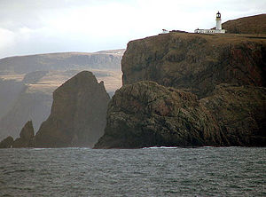
Cape Wrath
Encyclopedia
Headlands and bays
Headlands and bays are two related features of the coastal environment.- Geology and geography :Headlands and bays are often found on the same coastline. A bay is surrounded by land on three sides, whereas a headland is surrounded by water on three sides. Headlands are characterized by high,...
in Sutherland
Sutherland
Sutherland is a registration county, lieutenancy area and historic administrative county of Scotland. It is now within the Highland local government area. In Gaelic the area is referred to according to its traditional areas: Dùthaich 'IcAoidh , Asainte , and Cataibh...
, Highland
Highland (council area)
Highland is a council area in the Scottish Highlands and is the largest local government area in both Scotland and the United Kingdom as a whole. It shares borders with the council areas of Moray, Aberdeenshire, Perth and Kinross, and Argyll and Bute. Their councils, and those of Angus and...
, in northern Scotland
Scotland
Scotland is a country that is part of the United Kingdom. Occupying the northern third of the island of Great Britain, it shares a border with England to the south and is bounded by the North Sea to the east, the Atlantic Ocean to the north and west, and the North Channel and Irish Sea to the...
. It is the most northwesterly point on the island of Great Britain
Great Britain
Great Britain or Britain is an island situated to the northwest of Continental Europe. It is the ninth largest island in the world, and the largest European island, as well as the largest of the British Isles...
. The land between the Kyle of Durness and the lighthouse
Lighthouse
A lighthouse is a tower, building, or other type of structure designed to emit light from a system of lamps and lenses or, in older times, from a fire, and used as an aid to navigation for maritime pilots at sea or on inland waterways....
that is situated right at the tip, is known as the Parph, two hundred and seven square kilometers of virtually uninhabited moorland. The first road (now named the 'U70') in the district, built in 1828 by the lighthouse commission, was constructed across the Parph (580 37.5 N. Latitude; 500 00.0 W. Latitude) to Britain's most north westerly point. This road, is only accessible via the passenger ferry that crosses the Kyle of Durness.
Vikings would often turn their ships for home at Cape Wrath.
Cape Wrath is one of only two places prefixed with the name "Cape" in Great Britain, the other being Cape Cornwall
Cape Cornwall
Cape Cornwall is a small headland in Cornwall, UK. It is four miles north of Land's End near the town of St Just. A cape is the point of land where two bodies of water meet and until the first Ordnance Survey, 200 years ago, it was thought that Cape Cornwall was the most westerly point in...
in Cornwall
Cornwall
Cornwall is a unitary authority and ceremonial county of England, within the United Kingdom. It is bordered to the north and west by the Celtic Sea, to the south by the English Channel, and to the east by the county of Devon, over the River Tamar. Cornwall has a population of , and covers an area of...
.
Etymology and pronunciation
The name Cape Wrath, though perhaps apt when taken in context of its remote and forbidding landscape and frequent rough sea, is derived from Old Norse hvarf ("turning point"). In this context "Wrath" is pronounced ˈ (to rhyme with "math"), in contrast to the ordinary English word "wrath", usually pronounced ˈ in British English (to rhyme with "Goth").Climate
As with the rest of the British Isles, Cape Wrath has an OceanicOceanic climate
An oceanic climate, also called marine west coast climate, maritime climate, Cascadian climate and British climate for Köppen climate classification Cfb and subtropical highland for Köppen Cfb or Cwb, is a type of climate typically found along the west coasts at the middle latitudes of some of the...
(Köppen
Köppen climate classification
The Köppen climate classification is one of the most widely used climate classification systems. It was first published by Crimea German climatologist Wladimir Köppen in 1884, with several later modifications by Köppen himself, notably in 1918 and 1936...
Cfb) - this is especially pronounced due to its west, coastal location.
Its exposed northerly position can give rise to some exceptionally low winter sunshine levels - in January 1983 it recorded just 38 minutes of sunshine, a record low for Scotland. This exposed positioning however also means severe frost is unknown; when temperatures at Altnaharra or Kinbrace just 20 miles or so inland are -20 C or below, the temperature at Cape Wrath is often hovering close to freezing. For example, on the 30th of December 1995, when Altnaharra dropped to -27.0 C, the temperature at Cape Wrath fell to a mere -2.2 C. The record low of -6.9 C is comparable to those recorded on the Shetlands, Hebrides and even Scilly Isles of England, in spite of Cape Wrath's mainland location. A slight fohn effect can also occur with the right angle of southerly winds, exemplified by the record December high of 17.7 °C (63.9 °F).
Access

The more common approach is by taking a passenger ferry
Ferry
A ferry is a form of transportation, usually a boat, but sometimes a ship, used to carry primarily passengers, and sometimes vehicles and cargo as well, across a body of water. Most ferries operate on regular, frequent, return services...
from Keoldale near Durness
Durness
Durness is a huge but remote parish in the northwestern Highlands of Scotland, encompassing all the land between the Moine to the East and the Gualin to the West...
across the Kyle of Durness, and then walking, cycling or taking a minibus
Minibus
A minibus or minicoach is a passenger carrying motor vehicle that is designed to carry more people than a multi-purpose vehicle or minivan, but fewer people than a full-size bus. In the United Kingdom, the word "minibus" is used to describe any full-sized passenger carrying van. Minibuses have a...
for the journey of around 11 miles (17.7 km) to the lighthouse, which takes the visitor through a desolate and virtually uninhabited region, which is used as a military bombardment range by the Royal Navy
Royal Navy
The Royal Navy is the naval warfare service branch of the British Armed Forces. Founded in the 16th century, it is the oldest service branch and is known as the Senior Service...
and the Royal Air Force
Royal Air Force
The Royal Air Force is the aerial warfare service branch of the British Armed Forces. Formed on 1 April 1918, it is the oldest independent air force in the world...
; hence travel to the Cape is restricted at certain times of year. It is the only place in the Northern Hemisphere where NATO forces combine land, air, and sea capabilities in assault mode for training maneouvres, deploying ordnance up to 1000 pounds (453.6 kg) bombs.
Near to the ferry port is the old Ferryman's House (no longer inhabited). All that remains of the hamlet of Achiemore are a house (now used as a holiday home), a chequered prefab army building (the first MoD check-point for when the range is active) and the stone foundations of the old school, which was rarely attended by more than five pupils. Near by, is the old hamlet of Daill, where another house (now a holiday home) and a "temporary" bridge (constructed 1981 by the Army) spans the river Daill. Approximately 3.2 Km (2 miles) further, is the old hamlet of Inshore - where the only house that is still standing, is owned and used by the MoD. Further along the U70 road, a track to the right takes the traveller down to the old hamlet of Kearvaig, where there is a splendid beach and Kearvaig House which the Mountain Bothies Association
Mountain Bothies Association
The Mountain Bothies Association is a Scottish charity which looks after almost one hundred shelters in some of the remoter parts of the UK.Most of the MBA bothies are in Scotland, with others in the north of England and Wales...
have converted into a Bothy. Just off the shore, is Kearvaig Stack (also known as "The Cathedral" due to the appearance of two spires and a natural window created by the weather) - a notable local feature.
Four miles east of the cape lie the Clò Mór cliffs, the highest sea cliffs on the British mainland. Just a little further to the east, lies Garvie Island (An Garbh-eilean) which is one of the main targets the MoD use for their practicing.
Cape Wrath is also the turning point for the Cape Wrath Marathon, a particularly strenuous race due to the continuously undulating terrain. This runs for 11 miles (17.7 km) out to the lighthouse and the same distance back to the ferry dock on the Cape side. The final 4 miles (6.4 km) leg of this race is run from the mainland side from the ferry dock and finishes at Durness Community Centre. The marathon is held each year as the final event of a week of races called the Cape Wrath Challenge.
Lighthouse
There is a lighthouseLighthouse
A lighthouse is a tower, building, or other type of structure designed to emit light from a system of lamps and lenses or, in older times, from a fire, and used as an aid to navigation for maritime pilots at sea or on inland waterways....
at the cape, built in 1828 by Robert Stevenson
Robert Stevenson (civil engineer)
Robert Stevenson FRSE MInstCE FSAS MWS FGS FRAS FSA was a Scottish civil engineer and famed designer and builder of lighthouses.One of his finest achievements was the construction of the Bell Rock Lighthouse.-Early life:...
, which was manned until 1998, when it was converted to automatic operation by the Northern Lighthouse Board
Northern Lighthouse Board
The Northern Lighthouse Board is the General Lighthouse Authority for Scotland and the Isle of Man. It is a non-departmental public body responsible for marine navigation aids around coastal areas.-History:...
. Overlooking the Cape are the ruins of the Lloyd's
Lloyd's of London
Lloyd's, also known as Lloyd's of London, is a British insurance and reinsurance market. It serves as a partially mutualised marketplace where multiple financial backers, underwriters, or members, whether individuals or corporations, come together to pool and spread risk...
signal station which was used to monitor shipping.
The block of crumbling white houses next to the lighthouse are mostly currently disused, although one has been renovated over the past ten years, and another is home to a room with information about George Stephenson.
The sole inhabitants are now John Ure and his family, who leased the main building, converted it into a three-bedroomed home, and who have opened what is claimed to be Britain's most remote cafe on the site: the Ozone Cafe was opened in 2009 by the Princess Royal
Anne, Princess Royal
Princess Anne, Princess Royal , is the only daughter of Elizabeth II and Prince Philip, Duke of Edinburgh...
, and seats eight people. It is open all hours of the day and night throughout the year.
Wildlife
Due to its landscape largely untouched by humans, Cape Wrath has an excellent diversity of wildlife, including fulmarFulmar
Fulmars are seabirds of the family Procellariidae. The family consists of two extant species and two that are extinct.-Taxonomy:As members of Procellaridae and then the order Procellariiformes, they share certain traits. First, they have nasal passages that attach to the upper bill called...
, hooded crow
Hooded Crow
The Hooded Crow is a Eurasian bird species in the crow genus. Widely distributed, it is also known locally as Scotch Crow, Danish Crow, and Corbie or Grey Crow in Ireland, which is what its Welsh name, Brân Lwyd, translates as...
, rock pipit
Rock Pipit
The Rock Pipit, Anthus petrosus, is a small passerine bird species which breeds on rocky coasts of western Europe northwards from Brittany. It is mainly resident in Ireland, Great Britain and France, in the west of its range, but the Scandinavian and Russian populations migrate south in winter;...
, golden eagle
Golden Eagle
The Golden Eagle is one of the best known birds of prey in the Northern Hemisphere. Like all eagles, it belongs to the family Accipitridae. Once widespread across the Holarctic, it has disappeared from many of the more heavily populated areas...
, red deer
Red Deer
The red deer is one of the largest deer species. Depending on taxonomy, the red deer inhabits most of Europe, the Caucasus Mountains region, Asia Minor, parts of western Asia, and central Asia. It also inhabits the Atlas Mountains region between Morocco and Tunisia in northwestern Africa, being...
, cormorant
Great Cormorant
The Great Cormorant , known as the Great Black Cormorant across the Northern Hemisphere, the Black Cormorant in Australia and the Black Shag further south in New Zealand, is a widespread member of the cormorant family of seabirds...
and gannet
Gannet
Gannets are seabirds comprising the genus Morus, in the family Sulidae, closely related to the boobies.The gannets are large black and white birds with yellow heads. They have long pointed wings and long bills. Northern gannets are the largest seabirds in the North Atlantic, with a wingspan of up...
.
Shipwrecks
On September 27, 1915, while sailing for Scapa FlowScapa Flow
right|thumb|Scapa Flow viewed from its eastern endScapa Flow is a body of water in the Orkney Islands, Scotland, United Kingdom, sheltered by the islands of Mainland, Graemsay, Burray, South Ronaldsay and Hoy. It is about...
, HMS Caribbean (previously known as before being requisitioned for wartime service) foundered off Cape Wrath in bad weather. A tow by HMS Birkenhead was unsuccessful; 15 died. An inquiry later blamed the ship's carpenter for being insufficiently familiar with the ship and for failing to shut all the scuttles—like most of the crew, he had joined the ship just 10 days earlier. The ship served in various capacities during World War I
World War I
World War I , which was predominantly called the World War or the Great War from its occurrence until 1939, and the First World War or World War I thereafter, was a major war centred in Europe that began on 28 July 1914 and lasted until 11 November 1918...
, but she was best known for reducing the voyage time from Southampton
Southampton
Southampton is the largest city in the county of Hampshire on the south coast of England, and is situated south-west of London and north-west of Portsmouth. Southampton is a major port and the closest city to the New Forest...
, England
England
England is a country that is part of the United Kingdom. It shares land borders with Scotland to the north and Wales to the west; the Irish Sea is to the north west, the Celtic Sea to the south west, with the North Sea to the east and the English Channel to the south separating it from continental...
, to Cape Town
Cape Town
Cape Town is the second-most populous city in South Africa, and the provincial capital and primate city of the Western Cape. As the seat of the National Parliament, it is also the legislative capital of the country. It forms part of the City of Cape Town metropolitan municipality...
, South Africa
South Africa
The Republic of South Africa is a country in southern Africa. Located at the southern tip of Africa, it is divided into nine provinces, with of coastline on the Atlantic and Indian oceans...
, by half in the 1890s, and for transporting many famous soldiers and statesmen to and from the Cape Colony
Cape Colony
The Cape Colony, part of modern South Africa, was established by the Dutch East India Company in 1652, with the founding of Cape Town. It was subsequently occupied by the British in 1795 when the Netherlands were occupied by revolutionary France, so that the French revolutionaries could not take...
during the Second Boer War
Second Boer War
The Second Boer War was fought from 11 October 1899 until 31 May 1902 between the British Empire and the Afrikaans-speaking Dutch settlers of two independent Boer republics, the South African Republic and the Orange Free State...
. The wreck was found in 2004, 35 miles off Cape Wrath, undisturbed except for fishing nets.
External links
- http://www.capewrath.org.uk Information about Cape Wrath - including ferry times, the bus excursion and The Ozone Cafe, plus much more.
- http://northtothecape.tumblr.com Cape Wrath Trail expedition and information
- http://www.nlb.org.uk/ourlights/history/capewrath.htm History of Cape Wrath Lighthouse
- trekkingvisions Information about the Cape Wrath Trek