Cape Leeuwin
Encyclopedia
Australia (continent)
Australia is the world's smallest continent, comprising the mainland of Australia and proximate islands including Tasmania, New Guinea, the Aru Islands and Raja Ampat Islands...
, in the state of Western Australia
Western Australia
Western Australia is a state of Australia, occupying the entire western third of the Australian continent. It is bounded by the Indian Ocean to the north and west, the Great Australian Bight and Indian Ocean to the south, the Northern Territory to the north-east and South Australia to the south-east...
.
A few small islands and rocks, the St Alouarn Islands, extend further to the south. The nearest settlement, north of the cape, is Augusta
Augusta, Western Australia
Augusta is a town on the south-west coast of Western Australia, where the Blackwood River emerges into Flinders Bay. It is the nearest town to Cape Leeuwin, on the farthest south-west corner of the Australian continent. In the 2001 census it had a population of 1,694; by 2006 the population of...
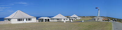
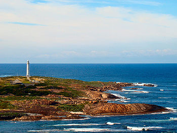
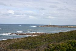
. South-east of Cape Leeuwin, the coast of Western Australia goes much further south. Located on headland of the cape is the Cape Leeuwin Lighthouse
Cape Leeuwin Lighthouse
The Cape Leeuwin Lighthouse is a lighthouse located on the headland of Cape Leeuwin, the most south-westerly point on the mainland of the Australian Continent, in the state of Western Australia....
and the buildings that were used by the lighthouse keepers.
In Australia
Australia
Australia , officially the Commonwealth of Australia, is a country in the Southern Hemisphere comprising the mainland of the Australian continent, the island of Tasmania, and numerous smaller islands in the Indian and Pacific Oceans. It is the world's sixth-largest country by total area...
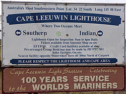
, the Cape is considered the point where the Indian Ocean
Indian Ocean
The Indian Ocean is the third largest of the world's oceanic divisions, covering approximately 20% of the water on the Earth's surface. It is bounded on the north by the Indian Subcontinent and Arabian Peninsula ; on the west by eastern Africa; on the east by Indochina, the Sunda Islands, and...
meets the Southern Ocean
Southern Ocean
The Southern Ocean comprises the southernmost waters of the World Ocean, generally taken to be south of 60°S latitude and encircling Antarctica. It is usually regarded as the fourth-largest of the five principal oceanic divisions...
; however most other nations and bodies consider the Southern Ocean to only exist south of 60°S
60th parallel south
The 60th parallel south is a circle of latitude that is 60 degrees south of the Earth's equatorial plane. No land lies on the parallel—it crosses nothing but ocean...
.
Use of name
Cape Leeuwin is often grouped with the next headland north, Cape NaturalisteCape Naturaliste
Cape Naturaliste is a headland in the south western region of Western Australia at the western edge of the Geographe Bay. It is the northernmost point of the Leeuwin-Naturaliste Ridge which was named after the cape...
, to identify the geography and ecology of the region. One example is in the name Leeuwin-Naturaliste National Park
Leeuwin-Naturaliste National Park
Leeuwin-Naturaliste National Park is a national park in the South West region of Western Australia , 267 km south of Perth.It is named after the two locations at either end of the park which have lighthouses, Cape Leeuwin and Cape Naturaliste....
. Another is in the use of the phrases Cape to Cape or the Capes in tourist promotional materials.
The Royal Australian Navy's
Royal Australian Navy
The Royal Australian Navy is the naval branch of the Australian Defence Force. Following the Federation of Australia in 1901, the ships and resources of the separate colonial navies were integrated into a national force: the Commonwealth Naval Forces...
Leeuwin class survey vessel
Leeuwin class survey vessel
The Leeuwin class is a class of two hydrographic survey vessels in the Royal Australian Navy, HMAS Leeuwin and HMAS Melville. Both ships were built by NQEA in Cairns, Queensland, and entered service in 2000....
HMAS Leeuwin
HMAS Leeuwin
HMAS Leeuwin is the lead ship of the Leeuwin Class of Hydrographic Survey vessels of the Royal Australian Navy .Leeuwin is named after Cape Leeuwin, in the South West of Western Australia, and is the first ship of the Royal Australian Navy to carry this name...
is named after the cape.
History
The first known ship to have visited the area is the Leeuwin ("Lioness"), a Dutch vessel that charted some of the nearby coastline in 1622. The log of the Leeuwin has been lost, so very little is known of the voyage. However, the land discovered by the Leeuwin was recorded on a 1627 map by Hessel Gerritsz: Caert van't Landt van d'Eendracht ("Chart of the Land of Eendracht"), which appears to show the coast between present-day Hamelin Bay and Point D’Entrecasteaux.[2] Cape Leeuwin itself cannot be recognised.Other European vessels passed by for the next two centuries, including the Dutch Gulden Zeepaard, commanded by Francois Thijssen, in 1627 and the French Gros Venture, under Louis Aleno de St Aloüarn, in 1772.
The first known sighting of the cape was by Bruni d'Entrecasteaux in 1791. d'Entrecasteaux thought the cape was an island, and named it "Isle St Allouarn" ("St Allouarn Island"), in honour of St Aloüarn. Ten years later, Matthew Flinders began his survey of the South coast of New Holland from Cape Leeuwin in 1801 and named it. Flinders landed in the bay to the east of Cape Leeuwin, today’s Flinders’ Bay. Flinders was aware that the area had been known to the Dutch as "Leeuwin's Land".
At two in the morning we had 80 fathoms, and veered towards the land. It was seen from the masthead at five; and the highest part, the same which had been set in the evening, bore N. 12° W. This is the largest of the before-mentioned Isles of St Alouarn; but at half past seven we saw hills extending from behind, and, to all appearance, joining it to the mainland. This supposed isle is, therefore, what I denominate "Cape Leeuwin", as being the south-western and most projecting part of Leeuwin's Land.[3]
There is a group of islands at the tip of Cape Leeuwin and it retains the name St Alouarn Islands. }} However, there is a group of islands at the tip of Cape Leeuwin and it retains the name St Alouarn Islands.
National Park
The hillside to the west of the tiny lighthouse, and the land nearby is now part of Leeuwin-Naturaliste National ParkLeeuwin-Naturaliste National Park
Leeuwin-Naturaliste National Park is a national park in the South West region of Western Australia , 267 km south of Perth.It is named after the two locations at either end of the park which have lighthouses, Cape Leeuwin and Cape Naturaliste....
. It has extensive heath vegetation and thick scrub which supports a very high number of plant species and also bird species that utilise this habitat.
The bay just east of Cape Leeuwin is Flinders Bay
Flinders Bay
Flinders Bay is a bay and locality that is immediately south of the townsite of Augusta, Western Australia, and close to the mouth of the Blackwood River and lies to the north east of Cape Leeuwin.-Bay:Flinders Bay...
, named after Matthew Flinders
Matthew Flinders
Captain Matthew Flinders RN was one of the most successful navigators and cartographers of his age. In a career that spanned just over twenty years, he sailed with Captain William Bligh, circumnavigated Australia and encouraged the use of that name for the continent, which had previously been...
, the circumnavigating explorer of the early 19th century.
Wrecks
Shipwrecks within sight of this location include the SS Pericles an Iron Screw steamer built in BelfastBelfast
Belfast is the capital of and largest city in Northern Ireland. By population, it is the 14th biggest city in the United Kingdom and second biggest on the island of Ireland . It is the seat of the devolved government and legislative Northern Ireland Assembly...
in Northern Ireland
Northern Ireland
Northern Ireland is one of the four countries of the United Kingdom. Situated in the north-east of the island of Ireland, it shares a border with the Republic of Ireland to the south and west...
, which sank after hitting an uncharted rock on a clear calm day in 1910. The wreck was found by Tom Snider in 1957 at - 34º 25. 33'S 115º 08.24'E. He dived on the wreck to recover the lead that was being carried by the ship.
Some shipwrecks are identified as being within the vicinity of Augusta, Cape Leeuwin or Hamelin Bay that might not be within visual distance of the lighthouse.
Further reading
- CALM/DOLA 1996. Land Management Series Map Sheet 1929-3 Leeuwin Edition 11:50000.
- (Edward DuykerEdward DuykerEdward Duyker is an Australian historian and author born in Melbourne, Victoria, to a father from the Netherlands and a mother from Mauritius...
(1987) The Dutch in Australia, AE Press, Melbourne. - (Edward Duyker & Maryse Duyker, ed. & trans) (2001) Bruny d’Entrecasteaux: Voyage to Australia and the Pacific 1791—1793, Miegunyah/Melbourne University Press, Melbourne. ISBN 0-522-84932-6
- Edward Duyker,(2006) François Péron: An Impetuous Life: Naturalist and Voyager, Miegunyah/MUP, Melb. ISBN 978-0522-85260-8,
- Eakin,Morgan (2003)Very Much on Watch - The Percy Willmott Photos Thornlie, W.A. Blackwood Publishing. ISBN 0-646-49939-4
- Fornasiero, Jean; Monteath, Peter and West-Sooby, John. (2004) Encountering Terra Australis: the Australian voyages of Nicholas Baudin and Matthew Flinders, Kent Town, South Australia, Wakefield Press ISBN 1-86254-625-8
- Fyfe, Christopher (1999) Uncharted end : the Pericles disaster An address to the Royal Western Australian Historical Society on 23 June 1999.
- Horner, Frank (1987) The French Reconnaissance: Baudin in Australia 1801—1803, Melbourne University Press, Melbourne, ISBN 0522843395.