

Cape Hatteras
Encyclopedia
Headlands and bays
Headlands and bays are two related features of the coastal environment.- Geology and geography :Headlands and bays are often found on the same coastline. A bay is surrounded by land on three sides, whereas a headland is surrounded by water on three sides. Headlands are characterized by high,...
on the coast of North Carolina
North Carolina
North Carolina is a state located in the southeastern United States. The state borders South Carolina and Georgia to the south, Tennessee to the west and Virginia to the north. North Carolina contains 100 counties. Its capital is Raleigh, and its largest city is Charlotte...
. It is the point that protrudes the farthest to the southeast along the northeast-to-southwest line of the Atlantic
Atlantic Ocean
The Atlantic Ocean is the second-largest of the world's oceanic divisions. With a total area of about , it covers approximately 20% of the Earth's surface and about 26% of its water surface area...
coast of North America
North America
North America is a continent wholly within the Northern Hemisphere and almost wholly within the Western Hemisphere. It is also considered a northern subcontinent of the Americas...
. Two major Atlantic currents collide just off Cape Hatteras, the southerly-flowing cold water Labrador Current
Labrador Current
The Labrador Current is a cold current in the North Atlantic Ocean which flows from the Arctic Ocean south along the coast of Labrador and passes around Newfoundland, continuing south along the east coast of Nova Scotia...
and the northerly-flowing warm water Florida Current
Florida Current
The Florida Current is a thermal ocean current that flows generally from the Gulf of Mexico to the Atlantic Ocean. The current was discovered by Spanish explorer Juan Ponce de León in 1513....
(Gulf Stream), creating turbulent waters and a large expanse of shallow sandbars extending up to 14 miles (22.5 km) offshore. These shoal
Shoal
Shoal, shoals or shoaling may mean:* Shoal, a sandbank or reef creating shallow water, especially where it forms a hazard to shipping* Shoal draught , of a boat with shallow draught which can pass over some shoals: see Draft...
s are known as Diamond Shoals. Because mariners utilize ocean currents to speed their journey, many ships venture close to Cape Hatteras when traveling along the eastern seaboard
East Coast of the United States
The East Coast of the United States, also known as the Eastern Seaboard, refers to the easternmost coastal states in the United States, which touch the Atlantic Ocean and stretch up to Canada. The term includes the U.S...
, risking the perils of sailing close to the shoals amid turbulent water and the frequent storms occurring in the area. So many ships have been lost off Cape Hatteras that the area is known as the "Graveyard of the Atlantic
Graveyard of the Atlantic
Graveyard of the Atlantic is a nickname of two locations known for numerous shipwrecks: the treacherous waters in the Atlantic Ocean along the Outer Banks of North Carolina and the Virginia coastline south of the entrance to the Chesapeake Bay at Cape Henry; and around Sable Island, off the coast...
".
The cape is actually a bend in Hatteras Island
Hatteras Island
Hatteras Island is a barrier island located off the North Carolina coast. Dividing the Atlantic Ocean and the Pamlico Sound, it runs parallel to the coast, forming a bend at Cape Hatteras. It is part of North Carolina's Outer Banks and includes the towns of Rodanthe, Waves, Salvo, Avon, Buxton,...
, one of the long thin barrier island
Barrier island
Barrier islands, a coastal landform and a type of barrier system, are relatively narrow strips of sand that parallel the mainland coast. They usually occur in chains, consisting of anything from a few islands to more than a dozen...
s that make up the Outer Banks
Outer Banks
The Outer Banks is a 200-mile long string of narrow barrier islands off the coast of North Carolina, beginning in the southeastern corner of Virginia Beach on the east coast of the United States....
. The first lighthouse
Lighthouse
A lighthouse is a tower, building, or other type of structure designed to emit light from a system of lamps and lenses or, in older times, from a fire, and used as an aid to navigation for maritime pilots at sea or on inland waterways....
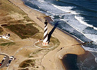
at the cape was built in 1803; it was replaced by the current Cape Hatteras Lighthouse in 1870, which at 198.48 feet (60.5 m) from the ground to the tip of its lightning rod is the tallest lighthouse in the United States and one of the tallest brick lighthouses in the world.
In 1999, as the receding shoreline had come dangerously close to Cape Hatteras Lighthouse, the 4830-ton lighthouse was lifted and moved inland a distance of 2900 feet (883.9 m). Its distance from the seashore is now 1500 feet (457.2 m), about the same as when it was originally built.
Somewhat analogous to Point Conception
Point Conception
Point Conception is a headland along the Pacific coast of U.S. state of California, located in southwestern Santa Barbara County. It is the point where the Santa Barbara Channel meets the Pacific Ocean, and as the corner between the mostly north-south trending portion of coast to the north and the...
in Southern California
Southern California
Southern California is a megaregion, or megapolitan area, in the southern area of the U.S. state of California. Large urban areas include Greater Los Angeles and Greater San Diego. The urban area stretches along the coast from Ventura through the Southland and Inland Empire to San Diego...
, this on-the-edge placement at the confluence of the Labrador and Florida currents leads to unusually diverse biological assemblages. Many species' ranges have either a southern or northern terminus at the cape.
Cape Hatteras is also infamous for being frequently struck by hurricanes that move up the East Coast of the United States
East Coast of the United States
The East Coast of the United States, also known as the Eastern Seaboard, refers to the easternmost coastal states in the United States, which touch the Atlantic Ocean and stretch up to Canada. The term includes the U.S...
. The strike of Hurricane Isabel
Hurricane Isabel
Hurricane Isabel was the costliest and deadliest hurricane in the 2003 Atlantic hurricane season. The ninth named storm, fifth hurricane, and second major hurricane of the season, Isabel formed near the Cape Verde Islands from a tropical wave on September 6 in the tropical Atlantic Ocean...
in 2003 was particularly devastating for the area. Isabel devastated the entire Outer Banks and also split Hatteras Island between the two small towns of Frisco
Frisco, North Carolina
Frisco is a small unincorporated community on the barrier island of Hatteras Island, between the villages of Buxton and Hatteras. It is located in Dare County, North Carolina, USA, and was previously named Trent, or Trent Woods, but received a new name with the coming of the post office in 1898...
and Hatteras
Hatteras, North Carolina
Hatteras is an unincorporated community in Dare County, North Carolina, United States, on the Outer Banks island of Hatteras. North Carolina Highway 12 passes through the community linking it to Frisco and Ocracoke . It is south of the famous Cape Hatteras and the Cape Hatteras Lighthouse in Buxton...
. NC 12
North Carolina State Highway 12
NC 12 is a North Carolina state highway that traverses the northeastern shoreline of North Carolina, linking the islands of the Outer Banks. It is a popular route for visitors touring the Outer Banks...
, which provides a direct route from Nags Head
Nags Head, North Carolina
Nags Head is a town in Dare County, North Carolina, United States. The population was 2,700 at the 2000 census.-History:Early maps of the area show Nags Head as a promontory of land characterized by high sand dunes visible from miles at sea...
to Hatteras Island
Hatteras Island
Hatteras Island is a barrier island located off the North Carolina coast. Dividing the Atlantic Ocean and the Pamlico Sound, it runs parallel to the coast, forming a bend at Cape Hatteras. It is part of North Carolina's Outer Banks and includes the towns of Rodanthe, Waves, Salvo, Avon, Buxton,...
, was washed out when the hurricane created a new inlet
Inlet
An inlet is a narrow body of water between islands or leading inland from a larger body of water, often leading to an enclosed body of water, such as a sound, bay, lagoon or marsh. In sea coasts an inlet usually refers to the actual connection between a bay and the ocean and is often called an...
. Students had to use a ferry
Ferry
A ferry is a form of transportation, usually a boat, but sometimes a ship, used to carry primarily passengers, and sometimes vehicles and cargo as well, across a body of water. Most ferries operate on regular, frequent, return services...
to get to school. The inlet was filled in with sand by the Army Corps of Engineers which took nearly two months to complete. The road, electrical and water lines were quickly rebuilt when the inlet was filled.
The name Hatteras is the sixth oldest surviving English place-name in the U.S. An inlet north of the cape was named "Hatrask" in 1585 by Sir Richard Grenville, the admiral leading the Roanoke Colony
Roanoke Colony
The Roanoke Colony on Roanoke Island in Dare County, present-day North Carolina, United States was a late 16th-century attempt to establish a permanent English settlement in what later became the Virginia Colony. The enterprise was financed and organized by Sir Walter Raleigh and carried out by...
expedition sent by Sir Walter Raleigh. It was later applied to the island and cape as well, and modified to "Hatteras".
Climate
Cape Hatteras displays a humid subtropical climateHumid subtropical climate
A humid subtropical climate is a climate zone characterized by hot, humid summers and mild to cool winters...
(Köppen
Köppen climate classification
The Köppen climate classification is one of the most widely used climate classification systems. It was first published by Crimea German climatologist Wladimir Köppen in 1884, with several later modifications by Köppen himself, notably in 1918 and 1936...
Cfa), with mild winters, and very warm and humid summers. Its location, jutting out into the Atlantic, helps moderate conditions throughout the year, produces small diurnal temperature ranges. The warmest days in July and August average 86 °F (30 °C), and there are only 6 days per summer above 90 °F (32 °C). The median freeze dates are March 16 and December 7. Snowfall is observed occasionally and most years do not see any accumulation. Rainfall is well-distributed throughout the years but is greatest in the latter half of summer, when hurricanes or their remnants can pass through.