.gif)
Cape Lookout (North Carolina)
Encyclopedia
This article is about the Cape Lookout in North Carolina. See Cape Lookout
for other places with a similar name.
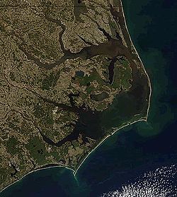
 Cape Lookout is southern point of the Core Banks, one of the natural barrier islands on the Atlantic coast of North Carolina
, USA
. delimits Onslow Bay
to the west from Raleigh Bay
to the east. Core Banks and Shackleford Banks
have been designated as part of Cape Lookout National Seashore
.
Cape Lookout is part of Carteret County
, 11 miles southeast of Beaufort, NC
.
The Cape Lookout Lighthouse
is located on the cape, approximately three miles northeast of the point of the cape.
Hurricane Irene
made landfall near the cape on Saturday, August 27, 2011 as a Category 1
storm with a very low pressure of 950 mbar.
Cape Lookout
Cape Lookout can refer to:*Cape Lookout , in the United States*Cape Lookout , in the United States*Cape Lookout...
for other places with a similar name.

North Carolina
North Carolina is a state located in the southeastern United States. The state borders South Carolina and Georgia to the south, Tennessee to the west and Virginia to the north. North Carolina contains 100 counties. Its capital is Raleigh, and its largest city is Charlotte...
, USA
United States
The United States of America is a federal constitutional republic comprising fifty states and a federal district...
. delimits Onslow Bay
Onslow Bay
Onslow Bay is an indentation of the North Carolina coast, between Cape Fear in the south and Cape Lookout in the north. Thirteen barrier islands form the shore of the bay. It is part of the open Atlantic Ocean and affords no protection from oceanic swells....
to the west from Raleigh Bay
Raleigh Bay
Raleigh Bay is an indentation of the North Carolina coast, between Cape Lookout in the south and Cape Hatteras in the north. The coastline of the bay is approximately 75 miles long, and consists of barrier islands, including Ocracoke Island. It is part of the open Atlantic Ocean and affords no...
to the east. Core Banks and Shackleford Banks
Shackleford Banks
Shackleford Banks is a barrier island system on the coast of Carteret County, North Carolina. It contains a herd of feral horses, scallop, crabs and various sea animals, including summer nesting by loggerhead turtles...
have been designated as part of Cape Lookout National Seashore
Cape Lookout National Seashore
Cape Lookout National Seashore preserves a 56-mile long section of the Southern Outer Banks, or Crystal Coast, of North Carolina, USA, running from Ocracoke Inlet on the northeast to Beaufort Inlet on the southeast. Three undeveloped barrier islands make up the seashore - North Core Banks, South...
.
Cape Lookout is part of Carteret County
Carteret County, North Carolina
Carteret County is a county located in the U.S. state of North Carolina. As of 2010, the population was 66,469. Its county seat is Beaufort. Most of the county is part of the Crystal Coast....
, 11 miles southeast of Beaufort, NC
Beaufort, North Carolina
Beaufort is a town in Carteret County, North Carolina, United States. Established in 1709, it is the third-oldest town in North Carolina.The population was 4,189 at the 2008 census and it is the county seat of Carteret County...
.
The Cape Lookout Lighthouse
Cape Lookout Lighthouse
The Cape Lookout Lighthouse is a 163-foot high lighthouse located on the Southern Outer Banks of North Carolina. It flashes every 15 seconds and is visible at least 12 miles out to sea and up to 19 miles. The Cape Lookout Light is one of the very few lighthouses that operate during the day. It...
is located on the cape, approximately three miles northeast of the point of the cape.
Hurricane Irene
Hurricane Irene (2011)
Hurricane Irene was a large and powerful Atlantic hurricane that left extensive flood and wind damage along its path through the Caribbean, the United States East Coast and as far north as Atlantic Canada in 2011...
made landfall near the cape on Saturday, August 27, 2011 as a Category 1
Saffir-Simpson Hurricane Scale
The Saffir–Simpson Hurricane Scale , or the Saffir–Simpson Hurricane Wind Scale , classifies hurricanes — Western Hemisphere tropical cyclones that exceed the intensities of tropical depressions and tropical storms — into five categories distinguished by the intensities of their sustained winds...
storm with a very low pressure of 950 mbar.

