

2010 Sahel famine
Encyclopedia
A large-scale, drought
-induced famine
occurred in Africa
's Sahel
region and many parts of the neighboring Sénégal River Area and Horn of Africa
from February to August 2010. It is one of many famines to have hit the region in recent times.
The Sahel
is the ecoclimatic and biogeographic zone of transition between the Sahara desert in the north of Africa
and the Sudanian savannas in the south, covering an area of 3,053,200 square kilometers. It is a transitional ecoregion
of semi-arid grasslands, savanna
s, steppes, and thorn shrublands.
The neighboring Sénégal River Area contains various vegetation types and covers parts or all of Mauritania
, Mali
, Senegal
and Guinea
. It has also had very low rainfall over the last year according to the UN, NGOs and the Senegal River Basin Development Authority
. Sudan set a new temperature record of 49.7°C (121.3°F) on June the 22nd, in the town of Dongola
.
: Eritrea
, the Sudan
, the Niger
, northern Nigeria
, northern Cameroon
, Chad
, Senegal
, Burkina Faso
, Mauritania
, Mali
, Ethiopia
, northern Kenya
and Djibouti
, as well as in parts of the neighboring Sénégal River Area.
In December 2009, both USAID and several NGOs predicted an increased food insecurity situation in more of the southern districts
of Mali as compared to the same time the previous year.
donor nations once theorised that the drought in the Sahel
primarily was caused by humans over-using natural resources
in the region through overgrazing
, deforestation
and poor land management
. In the late 1990s, climate model studies suggested that large-scale climate changes were also triggers for the drought.
In the early 2000s, after the phenomenon of global dimming
was discovered, some speculatively suggested, that the drought was likely caused by air pollution generated in Eurasia
and North America
. The pollution
changed the properties of clouds over the Atlantic Ocean
, disturbing the monsoon
s and shifting the tropical rain
s southwards. Global dimming
, the blocking of sunlight by man-made particulates, has been identified as one culprit for a decades-long drought across sub-Saharan Africa
, including Ethiopia
.
A 2006 study by NOAA scientists Rong Zhang and Thomas L. Delworth suggests that the Atlantic Multidecadal Oscillation
/(MAO) plays a leading role. An AMO warm phase strengthens the summer
rainfall over Sahel
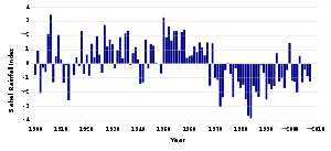
, while a cold phase reduces it. The AMO entered a warm phase in 1995 and, by assuming the presence of a thearetical 70-year cycle (following peaks in ≈1880 and ≈1950), it would probably peak around about 2020.
The Sahel’s farmers are largely cleared of blame for the 20th century’s Sahel droughts. The Sahel region’s droughts in the 1970s and 1980s were caused by the recent warming of the Indian Ocean
, and not by over farming causing environmental degradation as previously assumed, according to a new joint Scidev/UN study. With both a 3.5 C. rise in the Niger's temperature over the last decade and with irrigated
land accounting for only 0.1% of the Niger's inhabitable land, made a regular famine
crisis inevitable in most years. Acute water shortages are common in the region's harsh weather so making irrigation systems all the more important for the local farmers.
basin straddles over the borders of both Niger
, Nigeria
, Cameroon
and Chad
. The lake is situated 281 metres (921.9 ft) above sea level and is diminishing over time due to lack of rain water and major rivers running in to it. According to the UN the marshy lake shrank as much as by 95% from about 1963 to 1998 yet they also state that "The 2007 (satellite) image shows significant improvement over previous years". Lake Chad is economically important, providing water
to more than 20 million people living in the four countries that surround it (Chad
, Cameroon
, Niger
, and Nigeria
) on the edge of the Sahara Desert. The plant Typha Australis (or big cattails) are cutting off water supplies in the Lake Chad Basin
and has slashed available water supplies in the Chad’s region to. The only protected area is Lake Chad Game Reserve, which covers half of the area next to the lake that belongs to Nigeria. The whole lake has been declared a Ramsar site of international importance.
, a plan was proposed to divert the Ubangi River
into Lake Chad
. The copious amount of water from the Ubangi would revitalize the dying Lake Chad and provide livelihood in fishing and enhanced agriculture to tens of millions of central Africans and Sahel
ians. Inter-basin water transfer schemes were proposed in the 1980s
and 1990s
by Nigeria
n engineer J. Umolu (ZCN Scheme) and Italian
firm Bonifica (Transaqua Scheme). In 1994, the Lake Chad Basin Commission (LCBC) proposed a similar project and at a March, 2008 Summit, the Heads of State of the LCBC member countries committed to the diversion project. In April, 2008, the LCBC advertised a request for proposals for a World Bank-funded feasibility study.
and groundnut
s are two of Chad's four major cash crop
s. Mali's major cash crops are peanuts
and cotton. Mali
's cotton
production has grown from 500,000 tonnes in 1997 to a record 635,000 tonnes in 2003, which has pleased the African Association of Cotton Producers, but has also led to a claim that cash crops are being put before food and fodder crops in Mali
, Burkina Faso
and Chad
.
Cassava
production has fallen slightly in Burkina Faso
since 2007, relative to cotton output. Their cash crops are cotton
, groundnuts, shea nuts, and sesame
. The Sahel’s farmers are largely cleared of blame for the 20th century’s Sahel droughts, but there is the enduring question of whether cash crops like cotton
are more important than food plants like wheat
and casava.
, the Middle East
and South East Asia, have seen a sharp rise in population since the end of the Cold War
. The fear is that high population numbers are putting further strain on natural resources, food supplies, fuel supplies, employment, housing, etc.; in some of the less fortunate countries. The population
of Chad
has, for example, ultimately grown from 6,279,921 1993 to 10,329,208 in 2009, further straining its resources. Nigeria
, Egypt
and Ethiopia
are witnessing a similar growth in population, strained resources and a possible over-population
problem in the near future.
The situation was most acute in northern, western and central Africa
. Refugees from places like the Sudan
have helped further strain the resources of neighboring states like the Chad and Egypt. The nation is also host to roughly 255,000 refugee
s from Sudan’s Darfur
region, and about 77,000 refugees from the Central African Republic
, whilst approximately 188,000 Chadians have been displaced by their own civil war and famines, have either fled to either the Sudan, the Niger or, more recently, Libya
.
aid worker kidnapped in Chad. The kidnapping of foreigners along the Chad/Darfur border became more frequent in 2009. A French NGO worker was taken and then murder
ed on October 29, 2009, and an unidentified Red Cross worker was captured on November 10, 2009. Many NGOs and charities have started to restrict the areas covered by their aid work in Niger, Chad, and Sudan due to the ever present risk of bandits and kidnappers. The organisations are thus pulling out in fear of their lives.
Most international aid agencies withdraw workers from some areas of the Sahel, due to the regional kidnapping crisis. Niger
's government spokesman Mahamane Lawali Danda told the B.B.C.
that the pullout came as a surprise to him since no one had told him or his government Niger was on the list of dangerourse 'kidnapper infested' pariah nations, along with Chad
, Darfur
and Sudan
. Strangely Mauritania
and Mali
were not on the list of dangerous nations, despite of several al-Qaeda
lead kidnappings in both during 2009.
(WFP) and International Food Policy Research Institute
(IFPRI) warn of an imminent famine in parts of Ethiopia
, Somaliland
and Somalia
on January 1.
The Ethiopia
n government denied UN and WFP accusations that 20,000,000 are in need of food aid and that there is a famine in the north east, east and south west of the country on January 1. The WFP warned of major food shortages from January to March 2010. Ethiopia's government said only 6,000,000 need help from central government sources only. They also tried to downplay comparisons to and the number of victim actually recorded in the Great 1984–85 famine of Band Aid
and Live Aid
fame. Both Somalia and Somaliland were willing to take up the UN's offer of help.
January 11 saw an emerging famine situation in south eastern Sudan
according to the UN, NGOs, the EU and various Charities.
On 13 January the Irish
charity Hunger Organization sent aid and officials to Gorta in Kenya
’s part of the Great Rift Valley
, which is one of the most famine-effected regions.
Since 2009, the Horn of Africa
has been hit particularly hard, with an estimated 100,000 cattle dying in Kenya
during 2009 due to lack of water
.
The Kenyan government estimated that about 10,000,000 faced imminent food shortages and feared that a nationwide famine was about to unfold, with malnutrition
and disease-infested drinking water
adding to their fears. The drought had intensified in late 2009 and food had begun to run out in January, 2010.
The government of Niger
says 7,800,000 risk starvation in 2010 as heavy drought and high heat hit Niger, Burkina Faso
, Mali
, Chad
and northern Nigeria
on both January 27 and 28 and was estimated to need about $220,000,000 million this year in food and agricultural aid. The EU’s ECHO aid department
said of signs of food shortages were in Niger and spreading to neighbors such as Burkina Faso
, Mali
, Chad
and northern Nigeria
as 15,000,000 are estimated to face a chronic food shortage in Niger. The EU and UN also put out a famine alert for Niger, Burkina Faso
, Mali
, Chad
and northern Nigeria
and began to appeal for aid on the 28th. The EU, China
and Russia
stopped giving Niger aid in 2009 after President Mamadou Tandja defied UN, EU and worldwide criticism over extending his term in office.
in the Southern Kordofan department. The rainfall was reported at an all time low in Mauritania
and neighboring parts of Senegal
during most of February and early March.
The EU warns of a pending Sahel famine centered upon Niger, Burkina Faso and Chad on February 1.
Several NGOs said 3,500,000 Somalia
ns were also in danger of falling victim to famine conditions in their country on the 12th of February.
said that Al Qaeda should stop targeting African civilians and aid workers on March 16.
A drought
is confirmed to have hit parts of Burkina Faso
on March the 10th, by USAID and the UN.
March the 13th saw the UN, NGOs, the EU and various charities put out a famine alert for parts of southern Sudan
.
March 15 had Britain's Save The Children
charity launch an appeal as 840,000 Nigerians are confirmed to be in imminent risk of a famine.
On 17 March, a famine was declared in Mao in Chad’s sand-swept Kanem region
.
On March 23, 2010, major sandstorm
s hit Mauritania, Senegal, the Gambia, Guinea Bissau, Guinea
and inland Sierra Leone
. Another hit southern Algeria
, inland Mauritania
, Mali
and northern Côte d’Ivoire at the same time.
On March 31, the senior Eritrea
n diplomat
Tsfamariam Tekeste said, “Food aid in a normal situation cripples a society and the mentality of people. The people stop praying for rain and start praying for rain in the donor countries.” and that “Food aid had become an ‘industry’ in Eritrea.” Eritrean activist Mussie Hadgu said, “The humanitarian situation in the country is alarming,” in a interview with The Media Line, as a famine is officially reported in the reclusive police state. This is despite the fact that Eritrea has vast, untapped fish
eries.
(IR) sent aid workers to the North Kordofan to help improve their 16-year-old Um Dam and North Kordofan Water Project (NKWP). The UN, NGOs, charities and the Sudanese government reported that food security was a major concern in South Sudan and would stay at risk until the rainy season in September.
April 8 had starving
children and elders fill the wards of a hospital in Akobo
, Sudan
. Several aid groups like Save the Children
and Medair
found out that 46% of children in the region were malnourished. The U.N. blamed two years of failed rainfall and the ongoing tribal
clashes in the region for helping to create the humanitarian crisis
in southern Sudan. The World Food Programme
(WFP) was feeding 80,000 (up from 20,000 since April 2009) and the U.N. says 4,300,000 people in southern Sudan need food aid. The U.N. also said Akobo Woreda
in Ethiopia
was also experiencing rainfall shortages.
On April 23, 2010, said Niger
ien Culture Minister Aminata Takoubakoyea, there was a reported food supply deficit of 119,700 tonnes and a fodder supply deficit of 16,000,000 tonnes. Niger’s leading musicians and singers held a charity concert in Niamey
to assist.
n nation of Chad was on the verge of a nationwide famine as drought, armed conflict, and an influx of Darfur
refugees all contributed to a chronic food shortage that now affects 2,000,000 people (20% of the country's total population). Various aid groups, NGOs and charities
said a catastrophic famine could hit the country in the near future if food relief does not arrive soon. The UN warned that a famine had hit the town of Mao in Chad's Kanem
region.
The city of Niamey
, Niger
took in refugees from Tillabéri department
12 days before, after they turned up hoping the city would help them. The towns of Kongomé, Zinder
, Tanout
and Dalli
were the worst hit by the drought by May 3.
Morocco
gives a short term cash loan
to both the Niger
and Mali
.
NGOs and Charities report famine conditions Kindal region on the 5th.
On May 12 and 26, both Mauritania
, the Sénégal River Area and neighboring parts of both Senegal
and Mali
faced both drought and famine.
May 14 had USAID issue a food shortage alert for the Kordofan states.
Seven died of dehydration in Ghaidi Magha, Mauritania
, near the Mali
an border on May 18.
Afrol News reported on May 25 that about 2,000,000 Chadians were at risk of having a famine occur in their regions after the combined effects of 2 years of drought and pestilence had ruined their harvest yet again.
On May 27 and 28, Mali and Niger faced a famine situation in their northern territories. The Kidal, Timboktu and Gao
had their crops and live stock die off. Gao’s historic nomad market had virtually no food stuffs or animal fodder in it.
May 31 saw Chad
embroiled in a fiscal controversy. A 12 metre statue of a horseman, the Rond-point de la Grande Armée, in the capital N'djamena
, cost over $3,000,000. Both local critics, NGOs and overseas donor
nations all wondered where the money had come from and thought it would have been better spent on buying food and irrigation equipment.
, Kassala
, Janub Darfur, South Kordofan and North Kordofan departments.
Dehydration
was reported to have killed one person in Niger, while others in the region were at risk of water shortages on June 1.
Severe drought caused to 10,000,000 to go seriously short on as the Eastern Sahel crisis increases and local food prices surge on June 3. Niger has 7,100,00 victims, Chad has 2,000,000 victims and other country have 900,000 victims in total. Niger
, Chad
, the eastern parts of Mali
and northern Cameroon
have also been badly affected by the failed rains and scorching heat, according to the UN World Food Programme
. The WFP, which plans to assist 3,600,000 people in the coming months and said the crisis is expected to last at least until the next harvest in September 2010. The British
charity
Save the Children
, launched an emergency appeal for Niger. Starving families were reported as either have travelled more than 600 mile
s to reach the capital Niamey to find work and/or beg for food, while others have crossed the border in Nigeria
. A Similar situation is occurring in Chad as, desperate Chadians fled in to southern Libya
. Sudan
and Burkina Faso
were in a server food insecure situation to.
On June 6, growing famine in the Niger
drove thousand of refugee
s in to the Nigeria
n provinces of Kano
and Katsina
states. About 7,000,000 were facing a food shortage crisis in Niger.
On June 7 the Malian Government's Early Warning System
released an estimate that 258,000 people were suffering from malnutrition
in the towns of Gao
and Kidal in April. Low and erratic rain
fall in 2009 had occurred in Timbuktu
, Kidal, and Gao
, leading to a heavy regional drought
. Hundreds of refugees moved to Gao
from Burkina Faso
and Niger
, but were now too weak with starvation to leave Mali
. The UN and Mali's government asked the developed nations for food aid and financial help in the face of the growing humanitarian crisis. The amount taken in Nigeria's harvest was down by 65,000 tones, whilst Niger had virtually nothing to take from their harvest
.
June the 8th saw France
food aid to and the European Union
pledged an additional $28,000,000 million to help the millions of victims in the Niger
, the Chad
, Burkina Faso
, and northern Nigeria
. The charity Save the Children
sent a team to Aguie
in Niger
, 850 km north east from the capitol Niamey
, to set up an aid centre on the 8th and reported back on the 9th than 350,000 children faced severe malnutrition.
On June 9, various groups of hydrologists, geologists and scientists in the Sahara desert used magnetic imaging technology
when looking for aquifer
sites for drilling water wells in Eastern Chad
. Both northern Mali
, southern Libya
, southern Algeria
, eastern Chad were being examined in part of an ongoing project to find viable drilling as the region’s nations try to find new water sources to keep up with their growing demand. In recent years, roughly 300,000 refugees have arrived from both the war-torn Sudan and ailing Central African Republic
, thus straining the already limited water supplies. Both Algeria
, Burkina Faso
, Mauritania
, Morocco
, Mozambique
, Niger
have shown a major interest in the further development of this resource lead local industry.
On June 11, the UN's World Food Organisation, Oxfam and MSF all warned of an impending famine in Mali
, Mauritania
, Burkina Faso
, Niger
and northern Nigeria
. Niger's Diffa Region was of the most concern to the experts at hand.
June 13 saw roughly 30% crop failure in some of Niger’s provinces.
June 21 had International Fund for Agricultural Development
(IFAD) sent to 318,000 people in the drought hit Hargeisa
and Awdal
regions of Somaliland
as a new heat wave hit Niger on June 21, causing a increased area of drought in that country as well. Niger's crops failed and famine
occurred. About 350,000 faced starvation and 1,200,000 were at risk of famine
according to the Niger's government, while the UN said roughly 2,000,000 Chadians, 7,000,0000 Nigerians and 1,000,000 other people of the Sahel
region faced starvation and 200,000 Nigerian children were malnourished.
In over-heated Chad, the temperature reached 47.6°C (117.7°F) on June 22 in Faya-Largeau
, breaking a record set in 1961 at the same location. Niger tied its highest temperature record set in 1998, on also June 22, at 47.1°C in Bilma
. That record was broken the next day, on June 23 when Bilma hit 48.2°C (118.8°F). The hottest temperature recorded in Sudan was reached on June 22, at 49.7°C (121.3°F) in Dongola
, breaking a record set in 1987. Sudan's record temperature was matched on the 23rd too.
June 23 had the UN, WFP and various humanitarian agencies request $190,700,000 million to enable them respond to the unfolding famine in Niger. The UN estimates that just under 50% of country's 7,100,000 people risked starving to death. The UN and Ugandan also reported that the prolonged drought in 2009 which lasted nearly months and resent heavy rain storms had destroyed groundnut production in Uganda's Teso
and Kkumi
districts. The Ugandan government and NGOs feared that further Sudanese refugee influxes could cause heavy food shortages in Uganda.
On June 24 the government of Niger
admitted that it was suffering from a major famine
and said aid workers and NGOs were now welcome. The government of the Ivory Coast had reported to various NGOs that it was struggling to control desertification
and imminent drought conditions in parts of its northern savanna
lands. Oxfam
launch a £7,000,000 emergency appeal to try to help more than 800,000 of the most vulnerable people in Chad, Niger and Mali.
June 26 saw 1,600,000 Chadians facing food insecurity in the Bahr el Gazel Region, Batha Region
, Guera Region
, Hadjer-Lamis
Region, Lac Region
and the Kanem Region
. About 604,000 people were benefiting from its assistance as a total 60% of families became victims of the famine in varying degrees according to the UN’s World Food Programme
(WFP). Chad appealed to donors for increased contribution to the international famine relief operation in Chad
that received US$ 42,100,000 from of a pledged total of US$ 65,000,000, to enable it continue all its relief work and charitable activities until the end of the year 2010. Cameroon also suffered from heavy desertification in the savanna regions of South Region, Centre Region, West Region, Northwest Region and Far North Region.
's Blue Nile
, Janub Darfur, South Kordofan and North Kordofan departments. The Muslim Hands
charity set up an appeal and sent aid to Niger
and Mali
in July. It was the worst Niger famine
since 1984, with 3,500,000 people starving.
July 6 saw the Methodist Relief and Development Fund (MRDF) aid experts say that more than 1,500,000 Nigerians were at risk of famine due to a month-long heat wave that was hovering over Niger, Mali, Mauritania
and Morocco
. A fund of about £20,000 was distributed to the crisis-hit countries of Niger, Mali, Burkina Faso and Mauritania.
The heat wave
that left an overheating Morocco for the Iberian Peninsula
on July 11 was attributed to the regional hot air currents that depart from the Sahara
desert in Northern Africa at about 1,000 meters in altitude
. This facilitated a movement in the hot air towards the Balkans
and the Ukraine
via the Straits of Gibraltar, Spain
and Italy
. Unusually hot weather was also reported in parts of Algeria
on the July 11.
July 12 saw a local goat
farmer
killed and his small flock stolen by Chadian refugees in the South Darfur
region of the Sudan
. The UN's WFP body estimated that 2,500,000 were at risk of a famine breaking out in their part of Niger.
On July 13, the USAID funded Famine Early Warning Systems Network
(FEWS NET), and the UN warned of a food supply shortage in northern Sudan
, with increasing food insecurity focused on the war torn Darfur
region and other neighboring areas. The deteriorating security situation in the conflict zone was predicted to reduce both productivity and peoples' access to local agricultural well, as well as disrupting the seasonal livestock migration. USAID/OFDA provided $133,200,000 to the U.N. Food and Agriculture Organization (FAO
) to help remedy the crisis in the three Darfur states. Concerns were also raised about the situation in Chad, as well as those in parts of Eritrea and Ethiopia
.
Three years of famine and then the recent sandstorms devastated Niger on July 14. Diarrhoea, starvation, gastroenteritis
, malnutrition
and respiratory diseases kill and sicken many children. The new military junta
appealed for international food aid and has taken serious steps to call overseas help since coming to office in February 2010. Sudan witnessed minor food riot
ing in Southern Kordofan, Blue Nile
, and Abyei
as profiteering local and merchants and Uganda
n exporters took advantage of the shortages in order to heavily mark up their selling prices.
July 15 saw more border conflicts between the Nuer and the Dinka, further hindering aid workers in Southern Sudan.
On July 17, Mohamed Béavogui, the Director of Western and Central Africa Division of the International Fund for Agricultural Development
(IFAD), called for more international help for the people of the Sahel, who had a 410,000 tons of cereals and 20,000 tons of fodder deficit. He also condemned the world for not doing enough to help the Sahel, but stopped short of Cheminade's idea of pumping water from the Zaire River into Lake Chad
to reinvigorate its water supply and stop any further shrinkage.
On July 24, the British Red Cross
flew its logistics teams Bristol International Airport
to Niger to help the army and local officials with transportation. The relief effort has already been made possible by the response to the Red Cross's West Africa Crisis Appeal, which aims to raise £500,000. According to UN agencies, 200,000 children need treatment for malnutrition in Niger alone, as Oxfam
put out an £7,000,000 appeal to cover both Chad
and Niger.
France
sent unspecified food and cash aid to Mali on July 25.
On July 26 the heat reached near record levels over Chad and Niger, and about 20 had reportedly died in northern Niger of dehydration on July 27.
July 27 also saw a critical situation occurring in northern Mali and Chad. About 8,000,0000 Nigerians, 1,600,000 Chadians and 500,000 Malians were on the verge of a major food shortage as the Nigerian journalist Tidiane Kassé said that by tackling the consequences rather than the causes would be a better form of long-term help for the region.
On July 31, leading economists predicted that food prices, especially wheat, would rise in Chad as Russia
ends exports due to a domestic drought destroying their wheat and barley harvests.
suffered 35 °C heat and drought. On August 1, just under 12,000,000 people in Niger (approximately 80% of the nation's entire population
) faced a food supply crisis and possibly even famine
conditions. The Tillabéri
region is 30 km from the capital, Niamey
, on the road to the Sahara
n town of Timbuktu
. Unusually severe rainfall destroyed and then rotted the farmers' crops. Basic food stuffs like maize
, millet
and sorghum
were running out in West Africa
's Sahel
. Both Chad
and northern Nigeria
have a similar, but less severe problem.
On August 3, Burkina Faso
was hit by a drought
, as 4,500,000 Burkinans and 6,700,000 Nigerians faced starvation. Human Rights Watch
(HRW) said the Sudanese Nuer-Dinka
war was hampering relief efforts and damaging agricultural output in parts of South Sudan.
August 10 saw a Aljazeera reporter say that 7,500,000 Nigerians were at risk of famine and 15,000,000 could face a famine across the Sahel.
An estimated 8,000,000 people faced famine conditions in Niger on August 11. Senegal
and Gambia sent food aid to the Niger.
On August 12, Gianluca Ferrera, deputy director for the UN’s World Food Programme
in the Niger, said malnutrition and crop failures were at a record levels in 2010. Food shortages are affecting 12,000,000 people and 400,000 children face starvation
. Food prices rose by about 300% since the crisis began and thus hardly any one can afford to buy the remaining food.
August 14 saw protests across Sénégal
over concerns relating to the ruling party’s poor governance in the face of resent floods, storms and power cuts across the country, along with the current heavy drought in Senegal
's Sahel region.
August 15 had aid workers and their organizations warn of an imminent nationwide famine in Niger.
On August 20, floods which were the worst for 80 years hit the Shale region. The U.N. warned that Niger, Chad, Burkina Faso, Cameroon and northern Nigeria are also in the grip of the worst regional food crisis since 2006. In the savannah
Kano
, Nigeria, over 2,000 families were displaced by floods and in the nearby Jigawa region, an entire village was evacuated due to heavy flooding. A Mauritania
, a child
was swept in a flood
that have damaged bridge
s and many homes in the mountain town of Aioun
. Heavy flooding was occurring around parts of lake Chad
.
Most international aid agencies withdraw workers due to the regional kidnapping crisis. Niger
's government spokesman Mahamane Lawali Danda told the BBC
that the pullout came as a surprise since no one had told his government Niger was on the list of dangerous 'kidnapper infested' pariah state
s, along with Chad, Darfur
and Sudan
. Mauritania and Mali
were not on the list of dangerous nations, despite several al-Qaeda
lead kidnappings during 2009.
The U.N. warned of mass starvation in Niger and Chad and Oxfam
said people in the region were surviving on leaves and berries picked in the wild. 8,000,000 were said to be near starvation by both organisation. The UN estimated that up to 7,800,000 Nigerans were affected by heavy food shortages. Cafod
set up a £100,000 aid programme on August 21.
August 25 had a French
aid worker kidnapped in Chad. The kidnapping of foreigners along the Chad–Darfur border became more frequent in 2009. A French NGO worker was taken and then murder
ed on October 29, 2009, and an unidentified Red Cross worker was captured on November 10, 2009. Many NGOs and charities had started to restrict the areas covered by their aid work in Niger, Chad and Sudan, due to the ever-present risk of bandits and kidnapers.
On August 28, charities and NGOs put out food shortage alerts for Niger. Heavy rain falls on the border of the CAR
and the Chad.
August 31 saw 7,900,000 of Nigeria's 15,300,000 people in immediate risk of starvation and Gordon Brown
MP
making plans for a $100,000 charity speech on the development of irrigation and water schemes to increase cultivable land the Niger and the Chad. He was quoted to have said in the interview that:
On August 31 Sudan's army reported that 3 Russian helicopter crew members had been abducted by gunmen in Nyala, capital of South Darfur, just hours after Samaritan's Purse
aid worker Flavia Wagner who had been kidnapped May 18 was set free.. She was taken from the South Darfur
ian village of Abu Ajura, along with two Sudanese colleagues who were also freed after a week. The governor of South Darfur, Abdel Hamid Kasha, Sudan foreign ministry spokesman Moawiya Osman and Samaritan's Purse’s leader Franklin Graham
, and the Russian ambassador
to Chad welcomed Flavia’s release, but condemned the kidnap of the three Russians and that of two Jordan
ian UNAMID police advisers in Darfur, on the 14th. Another Russian helicopter
pilot was taken prisoner for four days after landing in South Darfur
to take rebels' spokesmen to Chad for alleged peace talks.
September 4 had Cholera
outbreaks kill 41 in Chad and one in Nigeria.
September 8 saw a Chinese CGC Overseas Construction Co. Ltd. oil worker kidnapped in Bahai inside Chad
and took him to Sharq al-Teyna, in Sudan
’s Darfur
region.
On September 13 the Prem Rawat Foundation gave $30,000 loan to pay for Niger
to buy food aid for children of its nomadic tribal groups.
On September 14 heavy rainfall in central and southern Chad raised hopes that the major drought in Africa's Sahel region would be over by early 2011. 10,000,000 were near to starvation in the Sahel
. The UN’s WFP had estimated that Chad needs about 100,000 metric tonnes of food aid, but had only received 70,000 metric tonnes so far. Most of the Chadian need to sell more cereal
crops to make enough money to repay their huge debts. farmers According to Jean Francois Caremel of the Action Against Hunger
charity
branch in Chad. As both Chad and Niger faced an improving situation due to heavy rain fall over these countries, but a major famine was still unfolding in other countries of West Africa's dry Sahelian region
September 15 had Sudanese and Chadian forces jointly searching for both the Chinese oil industry engineer
taken on the 8th and a Chinese aid worker who was kidnapped from the same town on the morning of the 15th. Both the Chinese ambassidor to Chad, the Chadian government
and the Solidarity Action for Peace and Development NGO condemned the kidnapping
s.
The Chinese hostage was released in the Dafur on the 17th.
September the 18th and 19th In Hadejia
, Nigeria
, The flood victims sleep wherever they can, the men search for dry spots on the roads while women and children keep piling into their houses still standing as huge number of displaced people have returned to flood-hit villages in Northern Nigeria. Over two million people were affected by the flood waters and more than 50,000 families are still wandering homeless. Residential areas of the Kararar Rima village was also destroyed in the flood. Most of the houses were made of clay, so they easy dissolved
in the flood water. As the rains fell the end of the pending famine looked close.
’s residents in Benin
had to board canoes, on the 9th due to severe flooding. According to the UN, 680,000 people were homeless while more than 300,000 acres of crops had been destroyed and 81,000 livestock killed.
Flooding began in mid-September when heavy rains caused the Niger River
in Benin's north to overflow and break its banks. Rainfall continued across the country.
Heavy rains caused the collapse of an already damaged dam in Ghana
and displaced more than 700,000 people.
The famine was finally relieved, but floods hit Ghana
, Niger
, Nigeria
and Benin
in October.
 Against a backdrop of conventional interventions through the state or markets, alternative initiatives have been pioneered to address the problem of food security. An example is the "Community Area-Based Development Approach" to agricultural development ("CABDA"), an NGO programme with the objective of providing an alternative approach to increasing food security in Africa. CABDA proceeds through specific areas of intervention such as the introduction of drought-resistant crops and new methods of food production such as agro-forestry. Piloted in Ethiopia
in the 1990s it has spread to Malawi
, Uganda
, Eritrea
and Kenya
. In an analysis of the programme by the Overseas Development Institute
, CABDA's focus on individual and community capacity-building is highlighted. This enables farmers to influence and drive their own development through community-run institutions, bringing food security to their household and region.
and Libya
were also tapping into the ancient Sub-Saharan aquifer and Bas Saharan Basin
as a source of drinking water, as of 2009 and 2008 respectively.
On June 9, 2010 various groups of hydrologists, geologists and scientists in the Sahara desert used magnetic imaging techniques when looking for sites in aquifer
s for drilling water wells in Eastern Chad
. Northern Mali
, southern Libya
, southern Algeria
, eastern Chad were being examined in part of an ongoing project to find viable drilling as the region’s nations try to find new water sources to keep up with their growing demand. Algeria
, Burkina Faso
, Mauritania
, Morocco
, Mozambique
, Niger
have shown a major interest in the further development of this resource lead local industry, which could prove a valuable asset for nomads, local farmers and townsfolk alike in the years to come.
(CILLS) and West Africa Club (SWAC), and the Gambia, which was also hosting the event. Mali, Mauritania, Senegal and the Gambia chose to express specific opinions on how to stop any further droughts in the region. The goal of the treaty is to help avert and mitigate the effects of future drought
s, famine
s and food shortages in the member states. The CILSS was created in 1973 during the first of the 'great droughts' of the late 20th Century.
Drought
A drought is an extended period of months or years when a region notes a deficiency in its water supply. Generally, this occurs when a region receives consistently below average precipitation. It can have a substantial impact on the ecosystem and agriculture of the affected region...
-induced famine
Famine
A famine is a widespread scarcity of food, caused by several factors including crop failure, overpopulation, or government policies. This phenomenon is usually accompanied or followed by regional malnutrition, starvation, epidemic, and increased mortality. Every continent in the world has...
occurred in Africa
Africa
Africa is the world's second largest and second most populous continent, after Asia. At about 30.2 million km² including adjacent islands, it covers 6% of the Earth's total surface area and 20.4% of the total land area...
's Sahel
Sahel
The Sahel is the ecoclimatic and biogeographic zone of transition between the Sahara desert in the North and the Sudanian Savannas in the south.It stretches across the North African continent between the Atlantic Ocean and the Red Sea....
region and many parts of the neighboring Sénégal River Area and Horn of Africa
Horn of Africa
The Horn of Africa is a peninsula in East Africa that juts hundreds of kilometers into the Arabian Sea and lies along the southern side of the Gulf of Aden. It is the easternmost projection of the African continent...
from February to August 2010. It is one of many famines to have hit the region in recent times.
The Sahel
Sahel
The Sahel is the ecoclimatic and biogeographic zone of transition between the Sahara desert in the North and the Sudanian Savannas in the south.It stretches across the North African continent between the Atlantic Ocean and the Red Sea....
is the ecoclimatic and biogeographic zone of transition between the Sahara desert in the north of Africa
Africa
Africa is the world's second largest and second most populous continent, after Asia. At about 30.2 million km² including adjacent islands, it covers 6% of the Earth's total surface area and 20.4% of the total land area...
and the Sudanian savannas in the south, covering an area of 3,053,200 square kilometers. It is a transitional ecoregion
Ecoregion
An ecoregion , sometimes called a bioregion, is an ecologically and geographically defined area that is smaller than an ecozone and larger than an ecosystem. Ecoregions cover relatively large areas of land or water, and contain characteristic, geographically distinct assemblages of natural...
of semi-arid grasslands, savanna
Savanna
A savanna, or savannah, is a grassland ecosystem characterized by the trees being sufficiently small or widely spaced so that the canopy does not close. The open canopy allows sufficient light to reach the ground to support an unbroken herbaceous layer consisting primarily of C4 grasses.Some...
s, steppes, and thorn shrublands.
The neighboring Sénégal River Area contains various vegetation types and covers parts or all of Mauritania
Mauritania
Mauritania is a country in the Maghreb and West Africa. It is bordered by the Atlantic Ocean in the west, by Western Sahara in the north, by Algeria in the northeast, by Mali in the east and southeast, and by Senegal in the southwest...
, Mali
Mali
Mali , officially the Republic of Mali , is a landlocked country in Western Africa. Mali borders Algeria on the north, Niger on the east, Burkina Faso and the Côte d'Ivoire on the south, Guinea on the south-west, and Senegal and Mauritania on the west. Its size is just over 1,240,000 km² with...
, Senegal
Senegal
Senegal , officially the Republic of Senegal , is a country in western Africa. It owes its name to the Sénégal River that borders it to the east and north...
and Guinea
Guinea
Guinea , officially the Republic of Guinea , is a country in West Africa. Formerly known as French Guinea , it is today sometimes called Guinea-Conakry to distinguish it from its neighbour Guinea-Bissau. Guinea is divided into eight administrative regions and subdivided into thirty-three prefectures...
. It has also had very low rainfall over the last year according to the UN, NGOs and the Senegal River Basin Development Authority
Organisation pour la mise en valeur du fleuve Sénégal
The Organisation pour la mise en valeur du fleuve Sénégal is an organisation of Guinea, Mali, Mauritania and Senegal to manage the Senegal River and its drainage basin....
. Sudan set a new temperature record of 49.7°C (121.3°F) on June the 22nd, in the town of Dongola
Dongola
Dongola , also spelled Dunqulah, and formerly known as Al 'Urdi, is the capital of the state of Northern in Sudan, on the banks of the Nile. It should not be confused with Old Dongola, an ancient city located 80 km upstream on the opposite bank....
.
Overview
Famine and food shortages were present in the following countries during 2010 after heavy rains hit the region in late 2009, followed by a heat waveHeat wave
A heat wave is a prolonged period of excessively hot weather, which may be accompanied by high humidity. There is no universal definition of a heat wave; the term is relative to the usual weather in the area...
: Eritrea
Eritrea
Eritrea , officially the State of Eritrea, is a country in the Horn of Africa. Eritrea derives it's name from the Greek word Erethria, meaning 'red land'. The capital is Asmara. It is bordered by Sudan in the west, Ethiopia in the south, and Djibouti in the southeast...
, the Sudan
Sudan
Sudan , officially the Republic of the Sudan , is a country in North Africa, sometimes considered part of the Middle East politically. It is bordered by Egypt to the north, the Red Sea to the northeast, Eritrea and Ethiopia to the east, South Sudan to the south, the Central African Republic to the...
, the Niger
Niger
Niger , officially named the Republic of Niger, is a landlocked country in Western Africa, named after the Niger River. It borders Nigeria and Benin to the south, Burkina Faso and Mali to the west, Algeria and Libya to the north and Chad to the east...
, northern Nigeria
Nigeria
Nigeria , officially the Federal Republic of Nigeria, is a federal constitutional republic comprising 36 states and its Federal Capital Territory, Abuja. The country is located in West Africa and shares land borders with the Republic of Benin in the west, Chad and Cameroon in the east, and Niger in...
, northern Cameroon
Cameroon
Cameroon, officially the Republic of Cameroon , is a country in west Central Africa. It is bordered by Nigeria to the west; Chad to the northeast; the Central African Republic to the east; and Equatorial Guinea, Gabon, and the Republic of the Congo to the south. Cameroon's coastline lies on the...
, Chad
Chad
Chad , officially known as the Republic of Chad, is a landlocked country in Central Africa. It is bordered by Libya to the north, Sudan to the east, the Central African Republic to the south, Cameroon and Nigeria to the southwest, and Niger to the west...
, Senegal
Senegal
Senegal , officially the Republic of Senegal , is a country in western Africa. It owes its name to the Sénégal River that borders it to the east and north...
, Burkina Faso
Burkina Faso
Burkina Faso – also known by its short-form name Burkina – is a landlocked country in west Africa. It is surrounded by six countries: Mali to the north, Niger to the east, Benin to the southeast, Togo and Ghana to the south, and Côte d'Ivoire to the southwest.Its size is with an estimated...
, Mauritania
Mauritania
Mauritania is a country in the Maghreb and West Africa. It is bordered by the Atlantic Ocean in the west, by Western Sahara in the north, by Algeria in the northeast, by Mali in the east and southeast, and by Senegal in the southwest...
, Mali
Mali
Mali , officially the Republic of Mali , is a landlocked country in Western Africa. Mali borders Algeria on the north, Niger on the east, Burkina Faso and the Côte d'Ivoire on the south, Guinea on the south-west, and Senegal and Mauritania on the west. Its size is just over 1,240,000 km² with...
, Ethiopia
Ethiopia
Ethiopia , officially known as the Federal Democratic Republic of Ethiopia, is a country located in the Horn of Africa. It is the second-most populous nation in Africa, with over 82 million inhabitants, and the tenth-largest by area, occupying 1,100,000 km2...
, northern Kenya
Kenya
Kenya , officially known as the Republic of Kenya, is a country in East Africa that lies on the equator, with the Indian Ocean to its south-east...
and Djibouti
Djibouti
Djibouti , officially the Republic of Djibouti , is a country in the Horn of Africa. It is bordered by Eritrea in the north, Ethiopia in the west and south, and Somalia in the southeast. The remainder of the border is formed by the Red Sea and the Gulf of Aden at the east...
, as well as in parts of the neighboring Sénégal River Area.
In December 2009, both USAID and several NGOs predicted an increased food insecurity situation in more of the southern districts
Cercles of Mali
A cercle is the second level administrative unit in Mali. Mali is divided into eight regions and one capital district . These subdivisions bear the name of their principal city. The regions are divided into 49 cercles....
of Mali as compared to the same time the previous year.
The possible causes
Environmental problems
The WesternWestern world
The Western world, also known as the West and the Occident , is a term referring to the countries of Western Europe , the countries of the Americas, as well all countries of Northern and Central Europe, Australia and New Zealand...
donor nations once theorised that the drought in the Sahel
Sahel
The Sahel is the ecoclimatic and biogeographic zone of transition between the Sahara desert in the North and the Sudanian Savannas in the south.It stretches across the North African continent between the Atlantic Ocean and the Red Sea....
primarily was caused by humans over-using natural resources
Natural Resources
Natural Resources is a soul album released by Motown girl group Martha Reeves and the Vandellas in 1970 on the Gordy label. The album is significant for the Vietnam War ballad "I Should Be Proud" and the slow jam, "Love Guess Who"...
in the region through overgrazing
Overgrazing
Overgrazing occurs when plants are exposed to intensive grazing for extended periods of time, or without sufficient recovery periods. It can be caused by either livestock in poorly managed agricultural applications, or by overpopulations of native or non-native wild animals.Overgrazing reduces the...
, deforestation
Deforestation
Deforestation is the removal of a forest or stand of trees where the land is thereafter converted to a nonforest use. Examples of deforestation include conversion of forestland to farms, ranches, or urban use....
and poor land management
Land management
Land management is the process of managing the use and development of land resources. Land resources are used for a variety of purposes which may include organic agriculture, reforestation, water resource management and eco-tourism projects.-See also:*Sustainable land management*Acreage...
. In the late 1990s, climate model studies suggested that large-scale climate changes were also triggers for the drought.
In the early 2000s, after the phenomenon of global dimming
Global dimming
Global dimming is the gradual reduction in the amount of global direct irradiance at the Earth's surface that was observed for several decades after the start of systematic measurements in the 1950s. The effect varies by location, but worldwide it has been estimated to be of the order of a 4%...
was discovered, some speculatively suggested, that the drought was likely caused by air pollution generated in Eurasia
Eurasia
Eurasia is a continent or supercontinent comprising the traditional continents of Europe and Asia ; covering about 52,990,000 km2 or about 10.6% of the Earth's surface located primarily in the eastern and northern hemispheres...
and North America
North America
North America is a continent wholly within the Northern Hemisphere and almost wholly within the Western Hemisphere. It is also considered a northern subcontinent of the Americas...
. The pollution
Pollution
Pollution is the introduction of contaminants into a natural environment that causes instability, disorder, harm or discomfort to the ecosystem i.e. physical systems or living organisms. Pollution can take the form of chemical substances or energy, such as noise, heat or light...
changed the properties of clouds over the Atlantic Ocean
Atlantic Ocean
The Atlantic Ocean is the second-largest of the world's oceanic divisions. With a total area of about , it covers approximately 20% of the Earth's surface and about 26% of its water surface area...
, disturbing the monsoon
Monsoon
Monsoon is traditionally defined as a seasonal reversing wind accompanied by corresponding changes in precipitation, but is now used to describe seasonal changes in atmospheric circulation and precipitation associated with the asymmetric heating of land and sea...
s and shifting the tropical rain
Tropical rain belt
The rainfall, and hence the tropical climate is dominated by the tropical rain belt, which oscillates from the northern to the southern tropics over the course of the year, roughly following the solar equator; it is largely a manifestation of the ITCZ...
s southwards. Global dimming
Global dimming
Global dimming is the gradual reduction in the amount of global direct irradiance at the Earth's surface that was observed for several decades after the start of systematic measurements in the 1950s. The effect varies by location, but worldwide it has been estimated to be of the order of a 4%...
, the blocking of sunlight by man-made particulates, has been identified as one culprit for a decades-long drought across sub-Saharan Africa
Sub-Saharan Africa
Sub-Saharan Africa as a geographical term refers to the area of the African continent which lies south of the Sahara. A political definition of Sub-Saharan Africa, instead, covers all African countries which are fully or partially located south of the Sahara...
, including Ethiopia
Ethiopia
Ethiopia , officially known as the Federal Democratic Republic of Ethiopia, is a country located in the Horn of Africa. It is the second-most populous nation in Africa, with over 82 million inhabitants, and the tenth-largest by area, occupying 1,100,000 km2...
.
A 2006 study by NOAA scientists Rong Zhang and Thomas L. Delworth suggests that the Atlantic Multidecadal Oscillation
Atlantic Multidecadal Oscillation
The Atlantic multidecadal oscillation is a mode of variability occurring in the North Atlantic Ocean and which has its principal expression in the sea surface temperature field...
/(MAO) plays a leading role. An AMO warm phase strengthens the summer
Summer
Summer is the warmest of the four temperate seasons, between spring and autumn. At the summer solstice, the days are longest and the nights are shortest, with day-length decreasing as the season progresses after the solstice...
rainfall over Sahel
Sahel
The Sahel is the ecoclimatic and biogeographic zone of transition between the Sahara desert in the North and the Sudanian Savannas in the south.It stretches across the North African continent between the Atlantic Ocean and the Red Sea....
, while a cold phase reduces it. The AMO entered a warm phase in 1995 and, by assuming the presence of a thearetical 70-year cycle (following peaks in ≈1880 and ≈1950), it would probably peak around about 2020.
The Sahel’s farmers are largely cleared of blame for the 20th century’s Sahel droughts. The Sahel region’s droughts in the 1970s and 1980s were caused by the recent warming of the Indian Ocean
Indian Ocean
The Indian Ocean is the third largest of the world's oceanic divisions, covering approximately 20% of the water on the Earth's surface. It is bounded on the north by the Indian Subcontinent and Arabian Peninsula ; on the west by eastern Africa; on the east by Indochina, the Sunda Islands, and...
, and not by over farming causing environmental degradation as previously assumed, according to a new joint Scidev/UN study. With both a 3.5 C. rise in the Niger's temperature over the last decade and with irrigated
Irrigation
Irrigation may be defined as the science of artificial application of water to the land or soil. It is used to assist in the growing of agricultural crops, maintenance of landscapes, and revegetation of disturbed soils in dry areas and during periods of inadequate rainfall...
land accounting for only 0.1% of the Niger's inhabitable land, made a regular famine
Famine
A famine is a widespread scarcity of food, caused by several factors including crop failure, overpopulation, or government policies. This phenomenon is usually accompanied or followed by regional malnutrition, starvation, epidemic, and increased mortality. Every continent in the world has...
crisis inevitable in most years. Acute water shortages are common in the region's harsh weather so making irrigation systems all the more important for the local farmers.
The demise of Lake Chad
The Lake ChadLake Chad
Lake Chad is a historically large, shallow, endorheic lake in Africa, whose size has varied over the centuries. According to the Global Resource Information Database of the United Nations Environment Programme, it shrank as much as 95% from about 1963 to 1998; yet it also states that "the 2007 ...
basin straddles over the borders of both Niger
Niger
Niger , officially named the Republic of Niger, is a landlocked country in Western Africa, named after the Niger River. It borders Nigeria and Benin to the south, Burkina Faso and Mali to the west, Algeria and Libya to the north and Chad to the east...
, Nigeria
Nigeria
Nigeria , officially the Federal Republic of Nigeria, is a federal constitutional republic comprising 36 states and its Federal Capital Territory, Abuja. The country is located in West Africa and shares land borders with the Republic of Benin in the west, Chad and Cameroon in the east, and Niger in...
, Cameroon
Cameroon
Cameroon, officially the Republic of Cameroon , is a country in west Central Africa. It is bordered by Nigeria to the west; Chad to the northeast; the Central African Republic to the east; and Equatorial Guinea, Gabon, and the Republic of the Congo to the south. Cameroon's coastline lies on the...
and Chad
Chad
Chad , officially known as the Republic of Chad, is a landlocked country in Central Africa. It is bordered by Libya to the north, Sudan to the east, the Central African Republic to the south, Cameroon and Nigeria to the southwest, and Niger to the west...
. The lake is situated 281 metres (921.9 ft) above sea level and is diminishing over time due to lack of rain water and major rivers running in to it. According to the UN the marshy lake shrank as much as by 95% from about 1963 to 1998 yet they also state that "The 2007 (satellite) image shows significant improvement over previous years". Lake Chad is economically important, providing water
Water
Water is a chemical substance with the chemical formula H2O. A water molecule contains one oxygen and two hydrogen atoms connected by covalent bonds. Water is a liquid at ambient conditions, but it often co-exists on Earth with its solid state, ice, and gaseous state . Water also exists in a...
to more than 20 million people living in the four countries that surround it (Chad
Chad
Chad , officially known as the Republic of Chad, is a landlocked country in Central Africa. It is bordered by Libya to the north, Sudan to the east, the Central African Republic to the south, Cameroon and Nigeria to the southwest, and Niger to the west...
, Cameroon
Cameroon
Cameroon, officially the Republic of Cameroon , is a country in west Central Africa. It is bordered by Nigeria to the west; Chad to the northeast; the Central African Republic to the east; and Equatorial Guinea, Gabon, and the Republic of the Congo to the south. Cameroon's coastline lies on the...
, Niger
Niger
Niger , officially named the Republic of Niger, is a landlocked country in Western Africa, named after the Niger River. It borders Nigeria and Benin to the south, Burkina Faso and Mali to the west, Algeria and Libya to the north and Chad to the east...
, and Nigeria
Nigeria
Nigeria , officially the Federal Republic of Nigeria, is a federal constitutional republic comprising 36 states and its Federal Capital Territory, Abuja. The country is located in West Africa and shares land borders with the Republic of Benin in the west, Chad and Cameroon in the east, and Niger in...
) on the edge of the Sahara Desert. The plant Typha Australis (or big cattails) are cutting off water supplies in the Lake Chad Basin
Chad Basin
The Chad Basin, also known as the Lake Chad Basin, is a large lowland area in north-central Africa. In all directions from the center of this area the elevation changes are gentle. The Chad Basin is an endorheic basin - its water does not flow into any ocean...
and has slashed available water supplies in the Chad’s region to. The only protected area is Lake Chad Game Reserve, which covers half of the area next to the lake that belongs to Nigeria. The whole lake has been declared a Ramsar site of international importance.
The Ubangi River diversion proposal
In the 1960s1960s
The 1960s was the decade that started on January 1, 1960, and ended on December 31, 1969. It was the seventh decade of the 20th century.The 1960s term also refers to an era more often called The Sixties, denoting the complex of inter-related cultural and political trends across the globe...
, a plan was proposed to divert the Ubangi River
Ubangi River
The Ubangi River , also spelled Oubangui, is the largest right-bank tributary of the Congo River of Central Africa. It begins at the confluence of the Mbomou and Uele Rivers and flows west, then bends to the southwest and passes through Bangui, after which it flows south to the Congo at Liranga....
into Lake Chad
Lake Chad
Lake Chad is a historically large, shallow, endorheic lake in Africa, whose size has varied over the centuries. According to the Global Resource Information Database of the United Nations Environment Programme, it shrank as much as 95% from about 1963 to 1998; yet it also states that "the 2007 ...
. The copious amount of water from the Ubangi would revitalize the dying Lake Chad and provide livelihood in fishing and enhanced agriculture to tens of millions of central Africans and Sahel
Sahel
The Sahel is the ecoclimatic and biogeographic zone of transition between the Sahara desert in the North and the Sudanian Savannas in the south.It stretches across the North African continent between the Atlantic Ocean and the Red Sea....
ians. Inter-basin water transfer schemes were proposed in the 1980s
1980s
File:1980s decade montage.png|thumb|400px|From left, clockwise: The first Space Shuttle, Columbia, lifted off in 1981; American President Ronald Reagan and Soviet leader Mikhail Gorbachev eased tensions between the two superpowers, leading to the end of the Cold War; The Fall of the Berlin Wall in...
and 1990s
1990s
File:1990s decade montage.png|From left, clockwise: The Hubble Space Telescope floats in space after it was taken up in 1990; American F-16s and F-15s fly over burning oil fields and the USA Lexie in Operation Desert Storm, also known as the 1991 Gulf War; The signing of the Oslo Accords on...
by Nigeria
Nigeria
Nigeria , officially the Federal Republic of Nigeria, is a federal constitutional republic comprising 36 states and its Federal Capital Territory, Abuja. The country is located in West Africa and shares land borders with the Republic of Benin in the west, Chad and Cameroon in the east, and Niger in...
n engineer J. Umolu (ZCN Scheme) and Italian
Italy
Italy , officially the Italian Republic languages]] under the European Charter for Regional or Minority Languages. In each of these, Italy's official name is as follows:;;;;;;;;), is a unitary parliamentary republic in South-Central Europe. To the north it borders France, Switzerland, Austria and...
firm Bonifica (Transaqua Scheme). In 1994, the Lake Chad Basin Commission (LCBC) proposed a similar project and at a March, 2008 Summit, the Heads of State of the LCBC member countries committed to the diversion project. In April, 2008, the LCBC advertised a request for proposals for a World Bank-funded feasibility study.
The possible effects of cash crops
CottonCotton
Cotton is a soft, fluffy staple fiber that grows in a boll, or protective capsule, around the seeds of cotton plants of the genus Gossypium. The fiber is almost pure cellulose. The botanical purpose of cotton fiber is to aid in seed dispersal....
and groundnut
Groundnut
Groundnut can mean:* Seeds that ripen underground, of the following plants, all in the Faboideae subfamily of the legumes:** Arachis villosulicarpa** Bambara groundnut** Hausa groundnut** Peanut* Roots and tubers:** Apios americana...
s are two of Chad's four major cash crop
Cash crop
In agriculture, a cash crop is a crop which is grown for profit.The term is used to differentiate from subsistence crops, which are those fed to the producer's own livestock or grown as food for the producer's family...
s. Mali's major cash crops are peanuts
Peanuts
Peanuts is a syndicated daily and Sunday American comic strip written and illustrated by Charles M. Schulz, which ran from October 2, 1950, to February 13, 2000, continuing in reruns afterward...
and cotton. Mali
Mali
Mali , officially the Republic of Mali , is a landlocked country in Western Africa. Mali borders Algeria on the north, Niger on the east, Burkina Faso and the Côte d'Ivoire on the south, Guinea on the south-west, and Senegal and Mauritania on the west. Its size is just over 1,240,000 km² with...
's cotton
Cotton
Cotton is a soft, fluffy staple fiber that grows in a boll, or protective capsule, around the seeds of cotton plants of the genus Gossypium. The fiber is almost pure cellulose. The botanical purpose of cotton fiber is to aid in seed dispersal....
production has grown from 500,000 tonnes in 1997 to a record 635,000 tonnes in 2003, which has pleased the African Association of Cotton Producers, but has also led to a claim that cash crops are being put before food and fodder crops in Mali
Mali
Mali , officially the Republic of Mali , is a landlocked country in Western Africa. Mali borders Algeria on the north, Niger on the east, Burkina Faso and the Côte d'Ivoire on the south, Guinea on the south-west, and Senegal and Mauritania on the west. Its size is just over 1,240,000 km² with...
, Burkina Faso
Burkina Faso
Burkina Faso – also known by its short-form name Burkina – is a landlocked country in west Africa. It is surrounded by six countries: Mali to the north, Niger to the east, Benin to the southeast, Togo and Ghana to the south, and Côte d'Ivoire to the southwest.Its size is with an estimated...
and Chad
Chad
Chad , officially known as the Republic of Chad, is a landlocked country in Central Africa. It is bordered by Libya to the north, Sudan to the east, the Central African Republic to the south, Cameroon and Nigeria to the southwest, and Niger to the west...
.
Cassava
Cassava
Cassava , also called yuca or manioc, a woody shrub of the Euphorbiaceae native to South America, is extensively cultivated as an annual crop in tropical and subtropical regions for its edible starchy tuberous root, a major source of carbohydrates...
production has fallen slightly in Burkina Faso
Burkina Faso
Burkina Faso – also known by its short-form name Burkina – is a landlocked country in west Africa. It is surrounded by six countries: Mali to the north, Niger to the east, Benin to the southeast, Togo and Ghana to the south, and Côte d'Ivoire to the southwest.Its size is with an estimated...
since 2007, relative to cotton output. Their cash crops are cotton
Cotton
Cotton is a soft, fluffy staple fiber that grows in a boll, or protective capsule, around the seeds of cotton plants of the genus Gossypium. The fiber is almost pure cellulose. The botanical purpose of cotton fiber is to aid in seed dispersal....
, groundnuts, shea nuts, and sesame
Sesame
Sesame is a flowering plant in the genus Sesamum. Numerous wild relatives occur in Africa and a smaller number in India. It is widely naturalized in tropical regions around the world and is cultivated for its edible seeds, which grow in pods....
. The Sahel’s farmers are largely cleared of blame for the 20th century’s Sahel droughts, but there is the enduring question of whether cash crops like cotton
Cotton
Cotton is a soft, fluffy staple fiber that grows in a boll, or protective capsule, around the seeds of cotton plants of the genus Gossypium. The fiber is almost pure cellulose. The botanical purpose of cotton fiber is to aid in seed dispersal....
are more important than food plants like wheat
Wheat
Wheat is a cereal grain, originally from the Levant region of the Near East, but now cultivated worldwide. In 2007 world production of wheat was 607 million tons, making it the third most-produced cereal after maize and rice...
and casava.
Over-population
Many of the world's countries, including many in Sub-saharan AfricaAfrica
Africa is the world's second largest and second most populous continent, after Asia. At about 30.2 million km² including adjacent islands, it covers 6% of the Earth's total surface area and 20.4% of the total land area...
, the Middle East
Middle East
The Middle East is a region that encompasses Western Asia and Northern Africa. It is often used as a synonym for Near East, in opposition to Far East...
and South East Asia, have seen a sharp rise in population since the end of the Cold War
Cold War
The Cold War was the continuing state from roughly 1946 to 1991 of political conflict, military tension, proxy wars, and economic competition between the Communist World—primarily the Soviet Union and its satellite states and allies—and the powers of the Western world, primarily the United States...
. The fear is that high population numbers are putting further strain on natural resources, food supplies, fuel supplies, employment, housing, etc.; in some of the less fortunate countries. The population
Population
A population is all the organisms that both belong to the same group or species and live in the same geographical area. The area that is used to define a sexual population is such that inter-breeding is possible between any pair within the area and more probable than cross-breeding with individuals...
of Chad
Chad
Chad , officially known as the Republic of Chad, is a landlocked country in Central Africa. It is bordered by Libya to the north, Sudan to the east, the Central African Republic to the south, Cameroon and Nigeria to the southwest, and Niger to the west...
has, for example, ultimately grown from 6,279,921 1993 to 10,329,208 in 2009, further straining its resources. Nigeria
Nigeria
Nigeria , officially the Federal Republic of Nigeria, is a federal constitutional republic comprising 36 states and its Federal Capital Territory, Abuja. The country is located in West Africa and shares land borders with the Republic of Benin in the west, Chad and Cameroon in the east, and Niger in...
, Egypt
Egypt
Egypt , officially the Arab Republic of Egypt, Arabic: , is a country mainly in North Africa, with the Sinai Peninsula forming a land bridge in Southwest Asia. Egypt is thus a transcontinental country, and a major power in Africa, the Mediterranean Basin, the Middle East and the Muslim world...
and Ethiopia
Ethiopia
Ethiopia , officially known as the Federal Democratic Republic of Ethiopia, is a country located in the Horn of Africa. It is the second-most populous nation in Africa, with over 82 million inhabitants, and the tenth-largest by area, occupying 1,100,000 km2...
are witnessing a similar growth in population, strained resources and a possible over-population
Overpopulation
Overpopulation is a condition where an organism's numbers exceed the carrying capacity of its habitat. The term often refers to the relationship between the human population and its environment, the Earth...
problem in the near future.
The situation was most acute in northern, western and central Africa
Africa
Africa is the world's second largest and second most populous continent, after Asia. At about 30.2 million km² including adjacent islands, it covers 6% of the Earth's total surface area and 20.4% of the total land area...
. Refugees from places like the Sudan
Sudan
Sudan , officially the Republic of the Sudan , is a country in North Africa, sometimes considered part of the Middle East politically. It is bordered by Egypt to the north, the Red Sea to the northeast, Eritrea and Ethiopia to the east, South Sudan to the south, the Central African Republic to the...
have helped further strain the resources of neighboring states like the Chad and Egypt. The nation is also host to roughly 255,000 refugee
Refugee
A refugee is a person who outside her country of origin or habitual residence because she has suffered persecution on account of race, religion, nationality, political opinion, or because she is a member of a persecuted 'social group'. Such a person may be referred to as an 'asylum seeker' until...
s from Sudan’s Darfur
Darfur
Darfur is a region in western Sudan. An independent sultanate for several hundred years, it was incorporated into Sudan by Anglo-Egyptian forces in 1916. The region is divided into three federal states: West Darfur, South Darfur, and North Darfur...
region, and about 77,000 refugees from the Central African Republic
Central African Republic
The Central African Republic , is a landlocked country in Central Africa. It borders Chad in the north, Sudan in the north east, South Sudan in the east, the Democratic Republic of the Congo and the Republic of the Congo in the south, and Cameroon in the west. The CAR covers a land area of about ,...
, whilst approximately 188,000 Chadians have been displaced by their own civil war and famines, have either fled to either the Sudan, the Niger or, more recently, Libya
Libya
Libya is an African country in the Maghreb region of North Africa bordered by the Mediterranean Sea to the north, Egypt to the east, Sudan to the southeast, Chad and Niger to the south, and Algeria and Tunisia to the west....
.
| Example nation | 1st Population total. | 2nd Population total. | 3rd Population total. | 4th Population total. | 5th Population total. | Life expectancy in years. | Total population growth from 1965, 6 or 1967 to 2008, 9 or 10. |
|---|---|---|---|---|---|---|---|
| Eritrea Eritrea Eritrea , officially the State of Eritrea, is a country in the Horn of Africa. Eritrea derives it's name from the Greek word Erethria, meaning 'red land'. The capital is Asmara. It is bordered by Sudan in the west, Ethiopia in the south, and Djibouti in the southeast... * |
N/A* | N/A* | 3,437,000 (1994) | 4,298,269 (2002) | 5,673,520 (2008) | 61 (2008) | 2,236,520* (since independence). |
| Ethiopia Ethiopia Ethiopia , officially known as the Federal Democratic Republic of Ethiopia, is a country located in the Horn of Africa. It is the second-most populous nation in Africa, with over 82 million inhabitants, and the tenth-largest by area, occupying 1,100,000 km2... * |
23,457,000 (1967)* | 50,974,000 (1990)* | 54,939,000 (1994) | 67,673,031 (2003) | 79,221,000 (2008) | 55 (2008) | 55,764,000* |
| Sudan Sudan Sudan , officially the Republic of the Sudan , is a country in North Africa, sometimes considered part of the Middle East politically. It is bordered by Egypt to the north, the Red Sea to the northeast, Eritrea and Ethiopia to the east, South Sudan to the south, the Central African Republic to the... ** |
14,355,000 (1967)** | 25,204,000 (1990)** | 27,361,000 (1994)** | 38,114,160 (2003)** | 42,272,000 (2008)** | 50 (2008)** | 27,917,000** |
| Chad Chad Chad , officially known as the Republic of Chad, is a landlocked country in Central Africa. It is bordered by Libya to the north, Sudan to the east, the Central African Republic to the south, Cameroon and Nigeria to the southwest, and Niger to the west... |
3,410,000 (1967) | 5,679,000 (1990) | 6,183,000 (1994) | 9,253,493 (2003) | 10,329,208 (2009) | 47 (2008) | 6,919,205 |
| Niger Niger Niger , officially named the Republic of Niger, is a landlocked country in Western Africa, named after the Niger River. It borders Nigeria and Benin to the south, Burkina Faso and Mali to the west, Algeria and Libya to the north and Chad to the east... |
3,546,000 (1967) | 7,732,000 (1990) | 8,846,000 (1994) | 10,790,352 (2001) | 15,306,252 (2009) | 44 (2008) | 11,760,252 |
| Nigeria Nigeria Nigeria , officially the Federal Republic of Nigeria, is a federal constitutional republic comprising 36 states and its Federal Capital Territory, Abuja. The country is located in West Africa and shares land borders with the Republic of Benin in the west, Chad and Cameroon in the east, and Niger in... |
61,450,000 (1967) | 88,500,000 (1990) | 108,467,000 (1994) | 129,934,911 (2002) | 158,259,000 (2008) | 47 (2008) | 96,809,000 |
| Mali Mali Mali , officially the Republic of Mali , is a landlocked country in Western Africa. Mali borders Algeria on the north, Niger on the east, Burkina Faso and the Côte d'Ivoire on the south, Guinea on the south-west, and Senegal and Mauritania on the west. Its size is just over 1,240,000 km² with... |
4,745,000 (1967) | 8,156,000 (1990), | 10,462,000 (1994) | 11,340,480 (2002) | 14,517,176 (2010). | 50 (2008) | 9,772,176 |
| Mauritania Mauritania Mauritania is a country in the Maghreb and West Africa. It is bordered by the Atlantic Ocean in the west, by Western Sahara in the north, by Algeria in the northeast, by Mali in the east and southeast, and by Senegal in the southwest... |
1,050,000 (1967) | 2,025,000 (1990) | 2,211,000 (1994) | 2,667,859 (2003) | 3,291,000 (2009) | 54 (2008) | 2,241,000 |
| Senegal Senegal Senegal , officially the Republic of Senegal , is a country in western Africa. It owes its name to the Sénégal River that borders it to the east and north... |
3,607,000 (1967) | 7,327,000 (1990) | 8,102,000 (1994) | 9,967,215 (2002) | 13,711,597 (2009) | 57 (2008) | 10,104,597 |
| Gambia | 343,000 (1967) | 861,000 (1990) | 1,081,000 (1994) | 1,367,124 (2000) | 1,705,000 (2008) | 55 (2008) | 1,362,000 |
| Algeria Algeria Algeria , officially the People's Democratic Republic of Algeria , also formally referred to as the Democratic and Popular Republic of Algeria, is a country in the Maghreb region of Northwest Africa with Algiers as its capital.In terms of land area, it is the largest country in Africa and the Arab... |
11,833,126 (1966) | 25,012,000 (1990) | 27,325,000 (1994) | 32,818,500 (2003) | 34,895,000 (2008) | 74 (2008) | 23,061,874 |
| Egypt Egypt Egypt , officially the Arab Republic of Egypt, Arabic: , is a country mainly in North Africa, with the Sinai Peninsula forming a land bridge in Southwest Asia. Egypt is thus a transcontinental country, and a major power in Africa, the Mediterranean Basin, the Middle East and the Muslim world... |
30,083,419 (1966) | 53,153,000 (1990) | 58,326,000 (1994) | 70,712,345 (2003) | 79,089,650 (2008) | 72 (2008) | 49,006,231 |
| UK (as a Western comparison) | 55,068,000 (1966) | 57,411,000 (1990) | 58,091,000 (1994) | 58,789,194 (2002) | 62,008,048(2011) | 79(2008) | 6,973,708 |
| Japan Japan Japan is an island nation in East Asia. Located in the Pacific Ocean, it lies to the east of the Sea of Japan, China, North Korea, South Korea and Russia, stretching from the Sea of Okhotsk in the north to the East China Sea and Taiwan in the south... *** (as a Western comparison) |
98,274,961 (1965) | 123,537,000 (1990) | 124,961,000 (1994) | 127,333,002 (2002) | 127,420,000 (2010) | 82 (2008) | 29,058,041 |
| Ryukyu Islands Ryukyu Islands The , also known as the , is a chain of islands in the western Pacific, on the eastern limit of the East China Sea and to the southwest of the island of Kyushu in Japan. From about 1829 until the mid 20th century, they were alternately called Luchu, Loochoo, or Lewchew, akin to the Mandarin... *** (as a Western comparison) |
934,176 (1965) | ||||||
| *=Includes Eritrea Eritrea Eritrea , officially the State of Eritrea, is a country in the Horn of Africa. Eritrea derives it's name from the Greek word Erethria, meaning 'red land'. The capital is Asmara. It is bordered by Sudan in the west, Ethiopia in the south, and Djibouti in the southeast... in the 1990 and 1967 Ethiopia Ethiopia Ethiopia , officially known as the Federal Democratic Republic of Ethiopia, is a country located in the Horn of Africa. It is the second-most populous nation in Africa, with over 82 million inhabitants, and the tenth-largest by area, occupying 1,100,000 km2... n figures. |
|||||||
| **=Split in to the nations of Sudan Sudan Sudan , officially the Republic of the Sudan , is a country in North Africa, sometimes considered part of the Middle East politically. It is bordered by Egypt to the north, the Red Sea to the northeast, Eritrea and Ethiopia to the east, South Sudan to the south, the Central African Republic to the... and Southern Sudan during 2011. |
|||||||
| ***=Merged in 1972. | |||||||
Aid workers being driven off by kidnappers
On August 25 had a FrenchFrench people
The French are a nation that share a common French culture and speak the French language as a mother tongue. Historically, the French population are descended from peoples of Celtic, Latin and Germanic origin, and are today a mixture of several ethnic groups...
aid worker kidnapped in Chad. The kidnapping of foreigners along the Chad/Darfur border became more frequent in 2009. A French NGO worker was taken and then murder
Murder
Murder is the unlawful killing, with malice aforethought, of another human being, and generally this state of mind distinguishes murder from other forms of unlawful homicide...
ed on October 29, 2009, and an unidentified Red Cross worker was captured on November 10, 2009. Many NGOs and charities have started to restrict the areas covered by their aid work in Niger, Chad, and Sudan due to the ever present risk of bandits and kidnappers. The organisations are thus pulling out in fear of their lives.
Most international aid agencies withdraw workers from some areas of the Sahel, due to the regional kidnapping crisis. Niger
Niger
Niger , officially named the Republic of Niger, is a landlocked country in Western Africa, named after the Niger River. It borders Nigeria and Benin to the south, Burkina Faso and Mali to the west, Algeria and Libya to the north and Chad to the east...
's government spokesman Mahamane Lawali Danda told the B.B.C.
BBC
The British Broadcasting Corporation is a British public service broadcaster. Its headquarters is at Broadcasting House in the City of Westminster, London. It is the largest broadcaster in the world, with about 23,000 staff...
that the pullout came as a surprise to him since no one had told him or his government Niger was on the list of dangerourse 'kidnapper infested' pariah nations, along with Chad
Chad
Chad , officially known as the Republic of Chad, is a landlocked country in Central Africa. It is bordered by Libya to the north, Sudan to the east, the Central African Republic to the south, Cameroon and Nigeria to the southwest, and Niger to the west...
, Darfur
Darfur
Darfur is a region in western Sudan. An independent sultanate for several hundred years, it was incorporated into Sudan by Anglo-Egyptian forces in 1916. The region is divided into three federal states: West Darfur, South Darfur, and North Darfur...
and Sudan
Sudan
Sudan , officially the Republic of the Sudan , is a country in North Africa, sometimes considered part of the Middle East politically. It is bordered by Egypt to the north, the Red Sea to the northeast, Eritrea and Ethiopia to the east, South Sudan to the south, the Central African Republic to the...
. Strangely Mauritania
Mauritania
Mauritania is a country in the Maghreb and West Africa. It is bordered by the Atlantic Ocean in the west, by Western Sahara in the north, by Algeria in the northeast, by Mali in the east and southeast, and by Senegal in the southwest...
and Mali
Mali
Mali , officially the Republic of Mali , is a landlocked country in Western Africa. Mali borders Algeria on the north, Niger on the east, Burkina Faso and the Côte d'Ivoire on the south, Guinea on the south-west, and Senegal and Mauritania on the west. Its size is just over 1,240,000 km² with...
were not on the list of dangerous nations, despite of several al-Qaeda
Al-Qaeda
Al-Qaeda is a global broad-based militant Islamist terrorist organization founded by Osama bin Laden sometime between August 1988 and late 1989. It operates as a network comprising both a multinational, stateless army and a radical Sunni Muslim movement calling for global Jihad...
lead kidnappings in both during 2009.
| Dates of 2008-2010 kidnapping incidents | The victims' nationalities | The location of the kidnapping | The victims' and kidnappers' fates. |
|---|---|---|---|
| 19 Oct 2008 |
9 Chinese | South Kordofan | All were killed. The Kidnappers were hanged in Sudan. |
| 29 Oct 2009 | 1 French | Eastern Chad | Killed in Darfur. |
| 10 Nov 2009. | 1 N/A | Chad. | N/A. |
| 26 Nov 2009 | 1 French | Northern Mali | N/A. |
| 1 Dec 2009 | 3 Spanish | Mauritania | Freed. The Malian kidnaper was sentenced to a 12 jail term in Mali. |
| 3 May 2010 | 1 Malian | Northern Mali | N/A. |
| 18 May 2010 | 2 Sudanese and 1 American | Abu Ajura, South Darfur South Darfur South Darfur is one of the 15 wilayat or states of Sudan. It is one of the three states that compose the region of Darfur in western Sudan. It has an area of and an estimated population of approximately 2,890,000 . Nyala is the capital of the state. The State was affected by the 2010 Sahel... |
Freed. |
| 23 Jun 2010 | 2 Germans | Darfur | N/A. |
| ? Jul 2010 | 1 Russian | South Darfur | Freed. |
| 26 Jul 2010 | 1 French | Mauritania | Killed in Mali. |
| 14 Aug 2010 | 2 Jordanians | Nyala Nyala The Nyala is a Southern African antelope. It is a spiral-horned dense-forest antelope that is uncomfortable in open spaces and is most often seen at water holes. Nyalas live alone or in small family groups of up to 10 individuals.The male stands up to 110 cm , the female is up to 90 cm ... , Darfur Darfur Darfur is a region in western Sudan. An independent sultanate for several hundred years, it was incorporated into Sudan by Anglo-Egyptian forces in 1916. The region is divided into three federal states: West Darfur, South Darfur, and North Darfur... |
Freed. |
| 25 Aug 2010 | 1 French | Chad | N/A |
| 31 Aug 2010 | 3 Russians | Nyala, Darfur | NA. |
| 15 Sept 2010 | 1 Chinese | The Chadian side of the Chad/Dafur border | Freed |
| 16 Sept 2010 | 5 French and 2 N/A | Niger | Currently held captive. |
January
Both the Famine Early Warning System (FEWS), UN’s World Food ProgrammeWorld Food Programme
The World Food Programme is the food aid branch of the United Nations, and the world's largest humanitarian organization addressing hunger worldwide. WFP provides food, on average, to 90 million people per year, 58 million of whom are children...
(WFP) and International Food Policy Research Institute
International Food Policy Research Institute
The International Food Policy Research Institute is an international agricultural research center founded in the early 1970s to improve the understanding of national agricultural and food policies to promote the adoption of innovations in agricultural technology...
(IFPRI) warn of an imminent famine in parts of Ethiopia
Ethiopia
Ethiopia , officially known as the Federal Democratic Republic of Ethiopia, is a country located in the Horn of Africa. It is the second-most populous nation in Africa, with over 82 million inhabitants, and the tenth-largest by area, occupying 1,100,000 km2...
, Somaliland
Somaliland
Somaliland is an unrecognised self-declared sovereign state that is internationally recognised as an autonomous region of Somalia. The government of Somaliland regards itself as the successor state to the British Somaliland protectorate, which was independent for a few days in 1960 as the State of...
and Somalia
Somalia
Somalia , officially the Somali Republic and formerly known as the Somali Democratic Republic under Socialist rule, is a country located in the Horn of Africa. Since the outbreak of the Somali Civil War in 1991 there has been no central government control over most of the country's territory...
on January 1.
The Ethiopia
Ethiopia
Ethiopia , officially known as the Federal Democratic Republic of Ethiopia, is a country located in the Horn of Africa. It is the second-most populous nation in Africa, with over 82 million inhabitants, and the tenth-largest by area, occupying 1,100,000 km2...
n government denied UN and WFP accusations that 20,000,000 are in need of food aid and that there is a famine in the north east, east and south west of the country on January 1. The WFP warned of major food shortages from January to March 2010. Ethiopia's government said only 6,000,000 need help from central government sources only. They also tried to downplay comparisons to and the number of victim actually recorded in the Great 1984–85 famine of Band Aid
Band Aid (band)
Band Aid was a charity supergroup featuring British and Irish musicians and recording artists. It was founded in 1984 by Bob Geldof and Midge Ure to raise money for famine relief in Ethiopia by releasing the song "Do They Know It's Christmas?" for the Christmas market that year. The single...
and Live Aid
Live Aid
Live Aid was a dual-venue concert that was held on 13 July 1985. The event was organized by Bob Geldof and Midge Ure to raise funds for relief of the ongoing Ethiopian famine. Billed as the "global jukebox", the event was held simultaneously in Wembley Stadium in London, England, United Kingdom ...
fame. Both Somalia and Somaliland were willing to take up the UN's offer of help.
January 11 saw an emerging famine situation in south eastern Sudan
Sudan
Sudan , officially the Republic of the Sudan , is a country in North Africa, sometimes considered part of the Middle East politically. It is bordered by Egypt to the north, the Red Sea to the northeast, Eritrea and Ethiopia to the east, South Sudan to the south, the Central African Republic to the...
according to the UN, NGOs, the EU and various Charities.
On 13 January the Irish
Ireland
Ireland is an island to the northwest of continental Europe. It is the third-largest island in Europe and the twentieth-largest island on Earth...
charity Hunger Organization sent aid and officials to Gorta in Kenya
Kenya
Kenya , officially known as the Republic of Kenya, is a country in East Africa that lies on the equator, with the Indian Ocean to its south-east...
’s part of the Great Rift Valley
Great Rift Valley
The Great Rift Valley is a name given in the late 19th century by British explorer John Walter Gregory to the continuous geographic trench, approximately in length, that runs from northern Syria in Southwest Asia to central Mozambique in South East Africa...
, which is one of the most famine-effected regions.
Since 2009, the Horn of Africa
Horn of Africa
The Horn of Africa is a peninsula in East Africa that juts hundreds of kilometers into the Arabian Sea and lies along the southern side of the Gulf of Aden. It is the easternmost projection of the African continent...
has been hit particularly hard, with an estimated 100,000 cattle dying in Kenya
Kenya
Kenya , officially known as the Republic of Kenya, is a country in East Africa that lies on the equator, with the Indian Ocean to its south-east...
during 2009 due to lack of water
Water
Water is a chemical substance with the chemical formula H2O. A water molecule contains one oxygen and two hydrogen atoms connected by covalent bonds. Water is a liquid at ambient conditions, but it often co-exists on Earth with its solid state, ice, and gaseous state . Water also exists in a...
.
The Kenyan government estimated that about 10,000,000 faced imminent food shortages and feared that a nationwide famine was about to unfold, with malnutrition
Malnutrition
Malnutrition is the condition that results from taking an unbalanced diet in which certain nutrients are lacking, in excess , or in the wrong proportions....
and disease-infested drinking water
Drinking water
Drinking water or potable water is water pure enough to be consumed or used with low risk of immediate or long term harm. In most developed countries, the water supplied to households, commerce and industry is all of drinking water standard, even though only a very small proportion is actually...
adding to their fears. The drought had intensified in late 2009 and food had begun to run out in January, 2010.
The government of Niger
Niger
Niger , officially named the Republic of Niger, is a landlocked country in Western Africa, named after the Niger River. It borders Nigeria and Benin to the south, Burkina Faso and Mali to the west, Algeria and Libya to the north and Chad to the east...
says 7,800,000 risk starvation in 2010 as heavy drought and high heat hit Niger, Burkina Faso
Burkina Faso
Burkina Faso – also known by its short-form name Burkina – is a landlocked country in west Africa. It is surrounded by six countries: Mali to the north, Niger to the east, Benin to the southeast, Togo and Ghana to the south, and Côte d'Ivoire to the southwest.Its size is with an estimated...
, Mali
Mali
Mali , officially the Republic of Mali , is a landlocked country in Western Africa. Mali borders Algeria on the north, Niger on the east, Burkina Faso and the Côte d'Ivoire on the south, Guinea on the south-west, and Senegal and Mauritania on the west. Its size is just over 1,240,000 km² with...
, Chad
Chad
Chad , officially known as the Republic of Chad, is a landlocked country in Central Africa. It is bordered by Libya to the north, Sudan to the east, the Central African Republic to the south, Cameroon and Nigeria to the southwest, and Niger to the west...
and northern Nigeria
Nigeria
Nigeria , officially the Federal Republic of Nigeria, is a federal constitutional republic comprising 36 states and its Federal Capital Territory, Abuja. The country is located in West Africa and shares land borders with the Republic of Benin in the west, Chad and Cameroon in the east, and Niger in...
on both January 27 and 28 and was estimated to need about $220,000,000 million this year in food and agricultural aid. The EU’s ECHO aid department
ECHO (European Commission)
The Humanitarian Aid department of the European Commission , formerly known as the European Community Humanitarian Aid Office, is the European Commission's department for overseas humanitarian aid...
said of signs of food shortages were in Niger and spreading to neighbors such as Burkina Faso
Burkina Faso
Burkina Faso – also known by its short-form name Burkina – is a landlocked country in west Africa. It is surrounded by six countries: Mali to the north, Niger to the east, Benin to the southeast, Togo and Ghana to the south, and Côte d'Ivoire to the southwest.Its size is with an estimated...
, Mali
Mali
Mali , officially the Republic of Mali , is a landlocked country in Western Africa. Mali borders Algeria on the north, Niger on the east, Burkina Faso and the Côte d'Ivoire on the south, Guinea on the south-west, and Senegal and Mauritania on the west. Its size is just over 1,240,000 km² with...
, Chad
Chad
Chad , officially known as the Republic of Chad, is a landlocked country in Central Africa. It is bordered by Libya to the north, Sudan to the east, the Central African Republic to the south, Cameroon and Nigeria to the southwest, and Niger to the west...
and northern Nigeria
Nigeria
Nigeria , officially the Federal Republic of Nigeria, is a federal constitutional republic comprising 36 states and its Federal Capital Territory, Abuja. The country is located in West Africa and shares land borders with the Republic of Benin in the west, Chad and Cameroon in the east, and Niger in...
as 15,000,000 are estimated to face a chronic food shortage in Niger. The EU and UN also put out a famine alert for Niger, Burkina Faso
Burkina Faso
Burkina Faso – also known by its short-form name Burkina – is a landlocked country in west Africa. It is surrounded by six countries: Mali to the north, Niger to the east, Benin to the southeast, Togo and Ghana to the south, and Côte d'Ivoire to the southwest.Its size is with an estimated...
, Mali
Mali
Mali , officially the Republic of Mali , is a landlocked country in Western Africa. Mali borders Algeria on the north, Niger on the east, Burkina Faso and the Côte d'Ivoire on the south, Guinea on the south-west, and Senegal and Mauritania on the west. Its size is just over 1,240,000 km² with...
, Chad
Chad
Chad , officially known as the Republic of Chad, is a landlocked country in Central Africa. It is bordered by Libya to the north, Sudan to the east, the Central African Republic to the south, Cameroon and Nigeria to the southwest, and Niger to the west...
and northern Nigeria
Nigeria
Nigeria , officially the Federal Republic of Nigeria, is a federal constitutional republic comprising 36 states and its Federal Capital Territory, Abuja. The country is located in West Africa and shares land borders with the Republic of Benin in the west, Chad and Cameroon in the east, and Niger in...
and began to appeal for aid on the 28th. The EU, China
China
Chinese civilization may refer to:* China for more general discussion of the country.* Chinese culture* Greater China, the transnational community of ethnic Chinese.* History of China* Sinosphere, the area historically affected by Chinese culture...
and Russia
Russia
Russia or , officially known as both Russia and the Russian Federation , is a country in northern Eurasia. It is a federal semi-presidential republic, comprising 83 federal subjects...
stopped giving Niger aid in 2009 after President Mamadou Tandja defied UN, EU and worldwide criticism over extending his term in office.
February
The UN, NGOs and charities warn of heavy food insecurity in Southern Sudan throughout February due to an emerging famine and the ongoing conflict between Misseriya nomadNomad
Nomadic people , commonly known as itinerants in modern-day contexts, are communities of people who move from one place to another, rather than settling permanently in one location. There are an estimated 30-40 million nomads in the world. Many cultures have traditionally been nomadic, but...
in the Southern Kordofan department. The rainfall was reported at an all time low in Mauritania
Mauritania
Mauritania is a country in the Maghreb and West Africa. It is bordered by the Atlantic Ocean in the west, by Western Sahara in the north, by Algeria in the northeast, by Mali in the east and southeast, and by Senegal in the southwest...
and neighboring parts of Senegal
Senegal
Senegal , officially the Republic of Senegal , is a country in western Africa. It owes its name to the Sénégal River that borders it to the east and north...
during most of February and early March.
The EU warns of a pending Sahel famine centered upon Niger, Burkina Faso and Chad on February 1.
Several NGOs said 3,500,000 Somalia
Somalia
Somalia , officially the Somali Republic and formerly known as the Somali Democratic Republic under Socialist rule, is a country located in the Horn of Africa. Since the outbreak of the Somali Civil War in 1991 there has been no central government control over most of the country's territory...
ns were also in danger of falling victim to famine conditions in their country on the 12th of February.
March
Human Rights WatchHuman Rights Watch
Human Rights Watch is an international non-governmental organization that conducts research and advocacy on human rights. Its headquarters are in New York City and it has offices in Berlin, Beirut, Brussels, Chicago, Geneva, Johannesburg, London, Los Angeles, Moscow, Paris, San Francisco, Tokyo,...
said that Al Qaeda should stop targeting African civilians and aid workers on March 16.
A drought
Drought
A drought is an extended period of months or years when a region notes a deficiency in its water supply. Generally, this occurs when a region receives consistently below average precipitation. It can have a substantial impact on the ecosystem and agriculture of the affected region...
is confirmed to have hit parts of Burkina Faso
Burkina Faso
Burkina Faso – also known by its short-form name Burkina – is a landlocked country in west Africa. It is surrounded by six countries: Mali to the north, Niger to the east, Benin to the southeast, Togo and Ghana to the south, and Côte d'Ivoire to the southwest.Its size is with an estimated...
on March the 10th, by USAID and the UN.
March the 13th saw the UN, NGOs, the EU and various charities put out a famine alert for parts of southern Sudan
Sudan
Sudan , officially the Republic of the Sudan , is a country in North Africa, sometimes considered part of the Middle East politically. It is bordered by Egypt to the north, the Red Sea to the northeast, Eritrea and Ethiopia to the east, South Sudan to the south, the Central African Republic to the...
.
March 15 had Britain's Save The Children
Save the Children
Save the Children is an internationally active non-governmental organization that enforces children's rights, provides relief and helps support children in developing countries...
charity launch an appeal as 840,000 Nigerians are confirmed to be in imminent risk of a famine.
On 17 March, a famine was declared in Mao in Chad’s sand-swept Kanem region
Kanem Region
Kanem is one of the 22 regions of Chad, corresponding to the former prefecture of Kanem. Its capital is Mao. It is named after the famous Kanem Empire, which was centered in this vicinity.The region of Kanem is divided into 3 departments:-Demography:...
.
On March 23, 2010, major sandstorm
Dust storm
A dust / sand storm is a meteorological phenomenon common in arid and semi-arid regions. Dust storms arise when a gust front or other strong wind blows loose sand and dirt from a dry surface. Particles are transported by saltation and suspension, causing soil to move from one place and deposition...
s hit Mauritania, Senegal, the Gambia, Guinea Bissau, Guinea
Guinea
Guinea , officially the Republic of Guinea , is a country in West Africa. Formerly known as French Guinea , it is today sometimes called Guinea-Conakry to distinguish it from its neighbour Guinea-Bissau. Guinea is divided into eight administrative regions and subdivided into thirty-three prefectures...
and inland Sierra Leone
Sierra Leone
Sierra Leone , officially the Republic of Sierra Leone, is a country in West Africa. It is bordered by Guinea to the north and east, Liberia to the southeast, and the Atlantic Ocean to the west and southwest. Sierra Leone covers a total area of and has an estimated population between 5.4 and 6.4...
. Another hit southern Algeria
Algeria
Algeria , officially the People's Democratic Republic of Algeria , also formally referred to as the Democratic and Popular Republic of Algeria, is a country in the Maghreb region of Northwest Africa with Algiers as its capital.In terms of land area, it is the largest country in Africa and the Arab...
, inland Mauritania
Mauritania
Mauritania is a country in the Maghreb and West Africa. It is bordered by the Atlantic Ocean in the west, by Western Sahara in the north, by Algeria in the northeast, by Mali in the east and southeast, and by Senegal in the southwest...
, Mali
Mali
Mali , officially the Republic of Mali , is a landlocked country in Western Africa. Mali borders Algeria on the north, Niger on the east, Burkina Faso and the Côte d'Ivoire on the south, Guinea on the south-west, and Senegal and Mauritania on the west. Its size is just over 1,240,000 km² with...
and northern Côte d’Ivoire at the same time.
On March 31, the senior Eritrea
Eritrea
Eritrea , officially the State of Eritrea, is a country in the Horn of Africa. Eritrea derives it's name from the Greek word Erethria, meaning 'red land'. The capital is Asmara. It is bordered by Sudan in the west, Ethiopia in the south, and Djibouti in the southeast...
n diplomat
Diplomat
A diplomat is a person appointed by a state to conduct diplomacy with another state or international organization. The main functions of diplomats revolve around the representation and protection of the interests and nationals of the sending state, as well as the promotion of information and...
Tsfamariam Tekeste said, “Food aid in a normal situation cripples a society and the mentality of people. The people stop praying for rain and start praying for rain in the donor countries.” and that “Food aid had become an ‘industry’ in Eritrea.” Eritrean activist Mussie Hadgu said, “The humanitarian situation in the country is alarming,” in a interview with The Media Line, as a famine is officially reported in the reclusive police state. This is despite the fact that Eritrea has vast, untapped fish
Fish
Fish are a paraphyletic group of organisms that consist of all gill-bearing aquatic vertebrate animals that lack limbs with digits. Included in this definition are the living hagfish, lampreys, and cartilaginous and bony fish, as well as various extinct related groups...
eries.
April
During April and June, Islamic ReliefIslamic Relief
Islamic Relief Worldwide is a Muslim international relief and development organization consisting of a family of 15 aid agencies that aims to alleviate the suffering of the world’s poorest people...
(IR) sent aid workers to the North Kordofan to help improve their 16-year-old Um Dam and North Kordofan Water Project (NKWP). The UN, NGOs, charities and the Sudanese government reported that food security was a major concern in South Sudan and would stay at risk until the rainy season in September.
April 8 had starving
Starvation
Starvation is a severe deficiency in caloric energy, nutrient and vitamin intake. It is the most extreme form of malnutrition. In humans, prolonged starvation can cause permanent organ damage and eventually, death...
children and elders fill the wards of a hospital in Akobo
Akobo, Sudan
-Location:It is located in Akobo County, Jonglei State, in the northeastern part of South Sudan, near the International border with Ethiopia. Its location lies approximately , by road, northeast of Juba, the capital and largest city in the country.-Population:...
, Sudan
Sudan
Sudan , officially the Republic of the Sudan , is a country in North Africa, sometimes considered part of the Middle East politically. It is bordered by Egypt to the north, the Red Sea to the northeast, Eritrea and Ethiopia to the east, South Sudan to the south, the Central African Republic to the...
. Several aid groups like Save the Children
Save the Children
Save the Children is an internationally active non-governmental organization that enforces children's rights, provides relief and helps support children in developing countries...
and Medair
Medair
Medair is an international non-governmental organization NGO of humanitarian aid with a stated mission, "to seek out and serve the most vulnerable people affected by crises." Medair’s core competencies are emergency relief and rehabilitation...
found out that 46% of children in the region were malnourished. The U.N. blamed two years of failed rainfall and the ongoing tribal
Tribe
A tribe, viewed historically or developmentally, consists of a social group existing before the development of, or outside of, states.Many anthropologists use the term tribal society to refer to societies organized largely on the basis of kinship, especially corporate descent groups .Some theorists...
clashes in the region for helping to create the humanitarian crisis
Humanitarian crisis
A humanitarian crisis is an event or series of events which represents a critical threat to the health, safety, security or wellbeing of a community or other large group of people, usually over a wide area...
in southern Sudan. The World Food Programme
World Food Programme
The World Food Programme is the food aid branch of the United Nations, and the world's largest humanitarian organization addressing hunger worldwide. WFP provides food, on average, to 90 million people per year, 58 million of whom are children...
(WFP) was feeding 80,000 (up from 20,000 since April 2009) and the U.N. says 4,300,000 people in southern Sudan need food aid. The U.N. also said Akobo Woreda
Woreda
Woreda is an administrative division of Ethiopia , equivalent to a district . Woredas are composed of a number of Kebele, or neighborhood associations, which are the smallest unit of local government in Ethiopia...
in Ethiopia
Ethiopia
Ethiopia , officially known as the Federal Democratic Republic of Ethiopia, is a country located in the Horn of Africa. It is the second-most populous nation in Africa, with over 82 million inhabitants, and the tenth-largest by area, occupying 1,100,000 km2...
was also experiencing rainfall shortages.
On April 23, 2010, said Niger
Niger
Niger , officially named the Republic of Niger, is a landlocked country in Western Africa, named after the Niger River. It borders Nigeria and Benin to the south, Burkina Faso and Mali to the west, Algeria and Libya to the north and Chad to the east...
ien Culture Minister Aminata Takoubakoyea, there was a reported food supply deficit of 119,700 tonnes and a fodder supply deficit of 16,000,000 tonnes. Niger’s leading musicians and singers held a charity concert in Niamey
Niamey
-Population:While Niamey's population has grown steadily since independence, the droughts of the early 1970s and 1980s, along with the economic crisis of the early 1980s, have propelled an exodus of rural inhabitants to Niger's largest city...
to assist.
May
On May 1, the West AfricaWest Africa
West Africa or Western Africa is the westernmost region of the African continent. Geopolitically, the UN definition of Western Africa includes the following 16 countries and an area of approximately 5 million square km:-Flags of West Africa:...
n nation of Chad was on the verge of a nationwide famine as drought, armed conflict, and an influx of Darfur
Darfur
Darfur is a region in western Sudan. An independent sultanate for several hundred years, it was incorporated into Sudan by Anglo-Egyptian forces in 1916. The region is divided into three federal states: West Darfur, South Darfur, and North Darfur...
refugees all contributed to a chronic food shortage that now affects 2,000,000 people (20% of the country's total population). Various aid groups, NGOs and charities
Charitable organization
A charitable organization is a type of non-profit organization . It differs from other types of NPOs in that it centers on philanthropic goals A charitable organization is a type of non-profit organization (NPO). It differs from other types of NPOs in that it centers on philanthropic goals A...
said a catastrophic famine could hit the country in the near future if food relief does not arrive soon. The UN warned that a famine had hit the town of Mao in Chad's Kanem
Kanem Region
Kanem is one of the 22 regions of Chad, corresponding to the former prefecture of Kanem. Its capital is Mao. It is named after the famous Kanem Empire, which was centered in this vicinity.The region of Kanem is divided into 3 departments:-Demography:...
region.
The city of Niamey
Niamey
-Population:While Niamey's population has grown steadily since independence, the droughts of the early 1970s and 1980s, along with the economic crisis of the early 1980s, have propelled an exodus of rural inhabitants to Niger's largest city...
, Niger
Niger
Niger , officially named the Republic of Niger, is a landlocked country in Western Africa, named after the Niger River. It borders Nigeria and Benin to the south, Burkina Faso and Mali to the west, Algeria and Libya to the north and Chad to the east...
took in refugees from Tillabéri department
Tillabéri Department
Tillabéri is a department of the Tillabéri Region in Niger. Its capital lies at the city of Tillabéri, and contains the Communes of Ayorou , Anzourou, Dessa, Kourteye, and Sinder. Tillabéri is also the capitol of Tillabéri Region...
12 days before, after they turned up hoping the city would help them. The towns of Kongomé, Zinder
Zinder
Zinder is the second largest city in Niger, with a population of 170,574 by 2005 was estimated to be over 200,000...
, Tanout
Tanout
Tanout is a town in southern Niger. It is in Zinder Region, Tanout Department, north of the city of Zinder. It is the administrative capital of Tanout Department....
and Dalli
Dalli
Dalli may refer to:PeopleDalli is a surname of Italian origin, and has a related Spanish surname form Dali.*John Dalli a prominent Maltese politician, European Commissioner in the second Barroso Commission...
were the worst hit by the drought by May 3.
Morocco
Morocco
Morocco , officially the Kingdom of Morocco , is a country located in North Africa. It has a population of more than 32 million and an area of 710,850 km², and also primarily administers the disputed region of the Western Sahara...
gives a short term cash loan
Loan
A loan is a type of debt. Like all debt instruments, a loan entails the redistribution of financial assets over time, between the lender and the borrower....
to both the Niger
Niger
Niger , officially named the Republic of Niger, is a landlocked country in Western Africa, named after the Niger River. It borders Nigeria and Benin to the south, Burkina Faso and Mali to the west, Algeria and Libya to the north and Chad to the east...
and Mali
Mali
Mali , officially the Republic of Mali , is a landlocked country in Western Africa. Mali borders Algeria on the north, Niger on the east, Burkina Faso and the Côte d'Ivoire on the south, Guinea on the south-west, and Senegal and Mauritania on the west. Its size is just over 1,240,000 km² with...
.
NGOs and Charities report famine conditions Kindal region on the 5th.
On May 12 and 26, both Mauritania
Mauritania
Mauritania is a country in the Maghreb and West Africa. It is bordered by the Atlantic Ocean in the west, by Western Sahara in the north, by Algeria in the northeast, by Mali in the east and southeast, and by Senegal in the southwest...
, the Sénégal River Area and neighboring parts of both Senegal
Senegal
Senegal , officially the Republic of Senegal , is a country in western Africa. It owes its name to the Sénégal River that borders it to the east and north...
and Mali
Mali
Mali , officially the Republic of Mali , is a landlocked country in Western Africa. Mali borders Algeria on the north, Niger on the east, Burkina Faso and the Côte d'Ivoire on the south, Guinea on the south-west, and Senegal and Mauritania on the west. Its size is just over 1,240,000 km² with...
faced both drought and famine.
May 14 had USAID issue a food shortage alert for the Kordofan states.
Seven died of dehydration in Ghaidi Magha, Mauritania
Mauritania
Mauritania is a country in the Maghreb and West Africa. It is bordered by the Atlantic Ocean in the west, by Western Sahara in the north, by Algeria in the northeast, by Mali in the east and southeast, and by Senegal in the southwest...
, near the Mali
Mali
Mali , officially the Republic of Mali , is a landlocked country in Western Africa. Mali borders Algeria on the north, Niger on the east, Burkina Faso and the Côte d'Ivoire on the south, Guinea on the south-west, and Senegal and Mauritania on the west. Its size is just over 1,240,000 km² with...
an border on May 18.
Afrol News reported on May 25 that about 2,000,000 Chadians were at risk of having a famine occur in their regions after the combined effects of 2 years of drought and pestilence had ruined their harvest yet again.
On May 27 and 28, Mali and Niger faced a famine situation in their northern territories. The Kidal, Timboktu and Gao
Gao
Gao is a town in eastern Mali on the River Niger lying ESE of Timbuktu. Situated on the left bank of the river at the junction with the Tilemsi valley, it is the capital of the Gao Region and had a population of 86,663 in 2009....
had their crops and live stock die off. Gao’s historic nomad market had virtually no food stuffs or animal fodder in it.
May 31 saw Chad
Chad
Chad , officially known as the Republic of Chad, is a landlocked country in Central Africa. It is bordered by Libya to the north, Sudan to the east, the Central African Republic to the south, Cameroon and Nigeria to the southwest, and Niger to the west...
embroiled in a fiscal controversy. A 12 metre statue of a horseman, the Rond-point de la Grande Armée, in the capital N'djamena
N'Djamena
N'Djamena is the capital and largest city of Chad. A port on the Chari River, near the confluence with the Logone River, it directly faces the Cameroonian town of Kousséri, to which the city is connected by a bridge. It is also a special statute region, divided in 10 arrondissements. It is a...
, cost over $3,000,000. Both local critics, NGOs and overseas donor
Donation
A donation is a gift given by physical or legal persons, typically for charitable purposes and/or to benefit a cause. A donation may take various forms, including cash, services, new or used goods including clothing, toys, food, and vehicles...
nations all wondered where the money had come from and thought it would have been better spent on buying food and irrigation equipment.
June
NGOs, various charities and the UN warned of heavy food shortages and food insecurity in Sudan's Blue NileBlue Nile
The Blue Nile is a river originating at Lake Tana in Ethiopia. With the White Nile, the river is one of the two major tributaries of the Nile...
, Kassala
Kassala
Kassala is the capital of the state of Kassala in eastern Sudan. Its 2008 population was recorded to be 419,030. It is a market town and is famous for its fruit gardens. It was formerly a railroad hub, however, as of 2006 there was no operational railway station in Kassala and much of the track...
, Janub Darfur, South Kordofan and North Kordofan departments.
Dehydration
Dehydration
In physiology and medicine, dehydration is defined as the excessive loss of body fluid. It is literally the removal of water from an object; however, in physiological terms, it entails a deficiency of fluid within an organism...
was reported to have killed one person in Niger, while others in the region were at risk of water shortages on June 1.
Severe drought caused to 10,000,000 to go seriously short on as the Eastern Sahel crisis increases and local food prices surge on June 3. Niger has 7,100,00 victims, Chad has 2,000,000 victims and other country have 900,000 victims in total. Niger
Niger
Niger , officially named the Republic of Niger, is a landlocked country in Western Africa, named after the Niger River. It borders Nigeria and Benin to the south, Burkina Faso and Mali to the west, Algeria and Libya to the north and Chad to the east...
, Chad
Chad
Chad , officially known as the Republic of Chad, is a landlocked country in Central Africa. It is bordered by Libya to the north, Sudan to the east, the Central African Republic to the south, Cameroon and Nigeria to the southwest, and Niger to the west...
, the eastern parts of Mali
Mali
Mali , officially the Republic of Mali , is a landlocked country in Western Africa. Mali borders Algeria on the north, Niger on the east, Burkina Faso and the Côte d'Ivoire on the south, Guinea on the south-west, and Senegal and Mauritania on the west. Its size is just over 1,240,000 km² with...
and northern Cameroon
Cameroon
Cameroon, officially the Republic of Cameroon , is a country in west Central Africa. It is bordered by Nigeria to the west; Chad to the northeast; the Central African Republic to the east; and Equatorial Guinea, Gabon, and the Republic of the Congo to the south. Cameroon's coastline lies on the...
have also been badly affected by the failed rains and scorching heat, according to the UN World Food Programme
World Food Programme
The World Food Programme is the food aid branch of the United Nations, and the world's largest humanitarian organization addressing hunger worldwide. WFP provides food, on average, to 90 million people per year, 58 million of whom are children...
. The WFP, which plans to assist 3,600,000 people in the coming months and said the crisis is expected to last at least until the next harvest in September 2010. The British
United Kingdom
The United Kingdom of Great Britain and Northern IrelandIn the United Kingdom and Dependencies, other languages have been officially recognised as legitimate autochthonous languages under the European Charter for Regional or Minority Languages...
charity
Charitable organization
A charitable organization is a type of non-profit organization . It differs from other types of NPOs in that it centers on philanthropic goals A charitable organization is a type of non-profit organization (NPO). It differs from other types of NPOs in that it centers on philanthropic goals A...
Save the Children
Save the Children
Save the Children is an internationally active non-governmental organization that enforces children's rights, provides relief and helps support children in developing countries...
, launched an emergency appeal for Niger. Starving families were reported as either have travelled more than 600 mile
Mile
A mile is a unit of length, most commonly 5,280 feet . The mile of 5,280 feet is sometimes called the statute mile or land mile to distinguish it from the nautical mile...
s to reach the capital Niamey to find work and/or beg for food, while others have crossed the border in Nigeria
Nigeria
Nigeria , officially the Federal Republic of Nigeria, is a federal constitutional republic comprising 36 states and its Federal Capital Territory, Abuja. The country is located in West Africa and shares land borders with the Republic of Benin in the west, Chad and Cameroon in the east, and Niger in...
. A Similar situation is occurring in Chad as, desperate Chadians fled in to southern Libya
Libya
Libya is an African country in the Maghreb region of North Africa bordered by the Mediterranean Sea to the north, Egypt to the east, Sudan to the southeast, Chad and Niger to the south, and Algeria and Tunisia to the west....
. Sudan
Sudan
Sudan , officially the Republic of the Sudan , is a country in North Africa, sometimes considered part of the Middle East politically. It is bordered by Egypt to the north, the Red Sea to the northeast, Eritrea and Ethiopia to the east, South Sudan to the south, the Central African Republic to the...
and Burkina Faso
Burkina Faso
Burkina Faso – also known by its short-form name Burkina – is a landlocked country in west Africa. It is surrounded by six countries: Mali to the north, Niger to the east, Benin to the southeast, Togo and Ghana to the south, and Côte d'Ivoire to the southwest.Its size is with an estimated...
were in a server food insecure situation to.
On June 6, growing famine in the Niger
Niger
Niger , officially named the Republic of Niger, is a landlocked country in Western Africa, named after the Niger River. It borders Nigeria and Benin to the south, Burkina Faso and Mali to the west, Algeria and Libya to the north and Chad to the east...
drove thousand of refugee
Refugee
A refugee is a person who outside her country of origin or habitual residence because she has suffered persecution on account of race, religion, nationality, political opinion, or because she is a member of a persecuted 'social group'. Such a person may be referred to as an 'asylum seeker' until...
s in to the Nigeria
Nigeria
Nigeria , officially the Federal Republic of Nigeria, is a federal constitutional republic comprising 36 states and its Federal Capital Territory, Abuja. The country is located in West Africa and shares land borders with the Republic of Benin in the west, Chad and Cameroon in the east, and Niger in...
n provinces of Kano
Kano
Kano is a city in Nigeria and the capital of Kano State in Northern Nigeria. Its metropolitan population is the second largest in Nigeria after Lagos. The Kano Urban area covers 137 sq.km and comprises six Local Government Area - Kano Municipal, Fagge, Dala, Gwale, Tarauni and Nassarawa - with a...
and Katsina
Katsina
Katsina is a city , and a Local Government Area in northern Nigeria, and is the capital of Katsina State. Katsina is located some 160 miles east of the city of Sokoto, and 84 miles northwest of Kano, close to the border with Niger. As of 2007, Katsina's estimated population was 459,022...
states. About 7,000,000 were facing a food shortage crisis in Niger.
On June 7 the Malian Government's Early Warning System
Warning system
A warning system is any system of biological or technical nature deployed by an individual or group to inform of a future danger. Its purpose is to enable the deployer of the warning system to prepare for the danger and act accordingly to mitigate or avoid it....
released an estimate that 258,000 people were suffering from malnutrition
Malnutrition
Malnutrition is the condition that results from taking an unbalanced diet in which certain nutrients are lacking, in excess , or in the wrong proportions....
in the towns of Gao
Gao
Gao is a town in eastern Mali on the River Niger lying ESE of Timbuktu. Situated on the left bank of the river at the junction with the Tilemsi valley, it is the capital of the Gao Region and had a population of 86,663 in 2009....
and Kidal in April. Low and erratic rain
Rain
Rain is liquid precipitation, as opposed to non-liquid kinds of precipitation such as snow, hail and sleet. Rain requires the presence of a thick layer of the atmosphere to have temperatures above the melting point of water near and above the Earth's surface...
fall in 2009 had occurred in Timbuktu
Timbuktu
Timbuktu , formerly also spelled Timbuctoo, is a town in the West African nation of Mali situated north of the River Niger on the southern edge of the Sahara Desert. The town is the capital of the Timbuktu Region, one of the eight administrative regions of Mali...
, Kidal, and Gao
Gao
Gao is a town in eastern Mali on the River Niger lying ESE of Timbuktu. Situated on the left bank of the river at the junction with the Tilemsi valley, it is the capital of the Gao Region and had a population of 86,663 in 2009....
, leading to a heavy regional drought
Drought
A drought is an extended period of months or years when a region notes a deficiency in its water supply. Generally, this occurs when a region receives consistently below average precipitation. It can have a substantial impact on the ecosystem and agriculture of the affected region...
. Hundreds of refugees moved to Gao
Gao
Gao is a town in eastern Mali on the River Niger lying ESE of Timbuktu. Situated on the left bank of the river at the junction with the Tilemsi valley, it is the capital of the Gao Region and had a population of 86,663 in 2009....
from Burkina Faso
Burkina Faso
Burkina Faso – also known by its short-form name Burkina – is a landlocked country in west Africa. It is surrounded by six countries: Mali to the north, Niger to the east, Benin to the southeast, Togo and Ghana to the south, and Côte d'Ivoire to the southwest.Its size is with an estimated...
and Niger
Niger
Niger , officially named the Republic of Niger, is a landlocked country in Western Africa, named after the Niger River. It borders Nigeria and Benin to the south, Burkina Faso and Mali to the west, Algeria and Libya to the north and Chad to the east...
, but were now too weak with starvation to leave Mali
Mali
Mali , officially the Republic of Mali , is a landlocked country in Western Africa. Mali borders Algeria on the north, Niger on the east, Burkina Faso and the Côte d'Ivoire on the south, Guinea on the south-west, and Senegal and Mauritania on the west. Its size is just over 1,240,000 km² with...
. The UN and Mali's government asked the developed nations for food aid and financial help in the face of the growing humanitarian crisis. The amount taken in Nigeria's harvest was down by 65,000 tones, whilst Niger had virtually nothing to take from their harvest
Harvest
Harvest is the process of gathering mature crops from the fields. Reaping is the cutting of grain or pulse for harvest, typically using a scythe, sickle, or reaper...
.
June the 8th saw France
France
The French Republic , The French Republic , The French Republic , (commonly known as France , is a unitary semi-presidential republic in Western Europe with several overseas territories and islands located on other continents and in the Indian, Pacific, and Atlantic oceans. Metropolitan France...
food aid to and the European Union
European Union
The European Union is an economic and political union of 27 independent member states which are located primarily in Europe. The EU traces its origins from the European Coal and Steel Community and the European Economic Community , formed by six countries in 1958...
pledged an additional $28,000,000 million to help the millions of victims in the Niger
Niger
Niger , officially named the Republic of Niger, is a landlocked country in Western Africa, named after the Niger River. It borders Nigeria and Benin to the south, Burkina Faso and Mali to the west, Algeria and Libya to the north and Chad to the east...
, the Chad
Chad
Chad , officially known as the Republic of Chad, is a landlocked country in Central Africa. It is bordered by Libya to the north, Sudan to the east, the Central African Republic to the south, Cameroon and Nigeria to the southwest, and Niger to the west...
, Burkina Faso
Burkina Faso
Burkina Faso – also known by its short-form name Burkina – is a landlocked country in west Africa. It is surrounded by six countries: Mali to the north, Niger to the east, Benin to the southeast, Togo and Ghana to the south, and Côte d'Ivoire to the southwest.Its size is with an estimated...
, and northern Nigeria
Nigeria
Nigeria , officially the Federal Republic of Nigeria, is a federal constitutional republic comprising 36 states and its Federal Capital Territory, Abuja. The country is located in West Africa and shares land borders with the Republic of Benin in the west, Chad and Cameroon in the east, and Niger in...
. The charity Save the Children
Save the Children
Save the Children is an internationally active non-governmental organization that enforces children's rights, provides relief and helps support children in developing countries...
sent a team to Aguie
Aguie
Aguie is a town and capital of the Aguie Department in southern Niger, 43 miles east of the nation's second largest city, Maradi.-Administrative structure:...
in Niger
Niger
Niger , officially named the Republic of Niger, is a landlocked country in Western Africa, named after the Niger River. It borders Nigeria and Benin to the south, Burkina Faso and Mali to the west, Algeria and Libya to the north and Chad to the east...
, 850 km north east from the capitol Niamey
Niamey
-Population:While Niamey's population has grown steadily since independence, the droughts of the early 1970s and 1980s, along with the economic crisis of the early 1980s, have propelled an exodus of rural inhabitants to Niger's largest city...
, to set up an aid centre on the 8th and reported back on the 9th than 350,000 children faced severe malnutrition.
On June 9, various groups of hydrologists, geologists and scientists in the Sahara desert used magnetic imaging technology
Imaging technology
Imaging technology is the application of materials and methods to create, preserve or duplicate images. This can mean several things:*Computer graphics*Microfilm and Micrographics*Visual arts**Etching**Drawing and Technical drawing**Cinema**Painting...
when looking for aquifer
Aquifer
An aquifer is a wet underground layer of water-bearing permeable rock or unconsolidated materials from which groundwater can be usefully extracted using a water well. The study of water flow in aquifers and the characterization of aquifers is called hydrogeology...
sites for drilling water wells in Eastern Chad
Chad
Chad , officially known as the Republic of Chad, is a landlocked country in Central Africa. It is bordered by Libya to the north, Sudan to the east, the Central African Republic to the south, Cameroon and Nigeria to the southwest, and Niger to the west...
. Both northern Mali
Mali
Mali , officially the Republic of Mali , is a landlocked country in Western Africa. Mali borders Algeria on the north, Niger on the east, Burkina Faso and the Côte d'Ivoire on the south, Guinea on the south-west, and Senegal and Mauritania on the west. Its size is just over 1,240,000 km² with...
, southern Libya
Libya
Libya is an African country in the Maghreb region of North Africa bordered by the Mediterranean Sea to the north, Egypt to the east, Sudan to the southeast, Chad and Niger to the south, and Algeria and Tunisia to the west....
, southern Algeria
Algeria
Algeria , officially the People's Democratic Republic of Algeria , also formally referred to as the Democratic and Popular Republic of Algeria, is a country in the Maghreb region of Northwest Africa with Algiers as its capital.In terms of land area, it is the largest country in Africa and the Arab...
, eastern Chad were being examined in part of an ongoing project to find viable drilling as the region’s nations try to find new water sources to keep up with their growing demand. In recent years, roughly 300,000 refugees have arrived from both the war-torn Sudan and ailing Central African Republic
Central African Republic
The Central African Republic , is a landlocked country in Central Africa. It borders Chad in the north, Sudan in the north east, South Sudan in the east, the Democratic Republic of the Congo and the Republic of the Congo in the south, and Cameroon in the west. The CAR covers a land area of about ,...
, thus straining the already limited water supplies. Both Algeria
Algeria
Algeria , officially the People's Democratic Republic of Algeria , also formally referred to as the Democratic and Popular Republic of Algeria, is a country in the Maghreb region of Northwest Africa with Algiers as its capital.In terms of land area, it is the largest country in Africa and the Arab...
, Burkina Faso
Burkina Faso
Burkina Faso – also known by its short-form name Burkina – is a landlocked country in west Africa. It is surrounded by six countries: Mali to the north, Niger to the east, Benin to the southeast, Togo and Ghana to the south, and Côte d'Ivoire to the southwest.Its size is with an estimated...
, Mauritania
Mauritania
Mauritania is a country in the Maghreb and West Africa. It is bordered by the Atlantic Ocean in the west, by Western Sahara in the north, by Algeria in the northeast, by Mali in the east and southeast, and by Senegal in the southwest...
, Morocco
Morocco
Morocco , officially the Kingdom of Morocco , is a country located in North Africa. It has a population of more than 32 million and an area of 710,850 km², and also primarily administers the disputed region of the Western Sahara...
, Mozambique
Mozambique
Mozambique, officially the Republic of Mozambique , is a country in southeastern Africa bordered by the Indian Ocean to the east, Tanzania to the north, Malawi and Zambia to the northwest, Zimbabwe to the west and Swaziland and South Africa to the southwest...
, Niger
Niger
Niger , officially named the Republic of Niger, is a landlocked country in Western Africa, named after the Niger River. It borders Nigeria and Benin to the south, Burkina Faso and Mali to the west, Algeria and Libya to the north and Chad to the east...
have shown a major interest in the further development of this resource lead local industry.
On June 11, the UN's World Food Organisation, Oxfam and MSF all warned of an impending famine in Mali
Mali
Mali , officially the Republic of Mali , is a landlocked country in Western Africa. Mali borders Algeria on the north, Niger on the east, Burkina Faso and the Côte d'Ivoire on the south, Guinea on the south-west, and Senegal and Mauritania on the west. Its size is just over 1,240,000 km² with...
, Mauritania
Mauritania
Mauritania is a country in the Maghreb and West Africa. It is bordered by the Atlantic Ocean in the west, by Western Sahara in the north, by Algeria in the northeast, by Mali in the east and southeast, and by Senegal in the southwest...
, Burkina Faso
Burkina Faso
Burkina Faso – also known by its short-form name Burkina – is a landlocked country in west Africa. It is surrounded by six countries: Mali to the north, Niger to the east, Benin to the southeast, Togo and Ghana to the south, and Côte d'Ivoire to the southwest.Its size is with an estimated...
, Niger
Niger
Niger , officially named the Republic of Niger, is a landlocked country in Western Africa, named after the Niger River. It borders Nigeria and Benin to the south, Burkina Faso and Mali to the west, Algeria and Libya to the north and Chad to the east...
and northern Nigeria
Nigeria
Nigeria , officially the Federal Republic of Nigeria, is a federal constitutional republic comprising 36 states and its Federal Capital Territory, Abuja. The country is located in West Africa and shares land borders with the Republic of Benin in the west, Chad and Cameroon in the east, and Niger in...
. Niger's Diffa Region was of the most concern to the experts at hand.
June 13 saw roughly 30% crop failure in some of Niger’s provinces.
June 21 had International Fund for Agricultural Development
International Fund for Agricultural Development
The International Fund for Agricultural Development , a specialized agency of the United Nations, was established as an international financial institution in 1977 as one of the major outcomes of the 1974 World Food Conference. IFAD is dedicated to eradicating rural poverty in developing countries...
(IFAD) sent to 318,000 people in the drought hit Hargeisa
Hargeisa
Hargeisa is a city in the northwestern Woqooyi Galbeed region of Somalia. With a population of approximately 2 million residents, it is the second largest city in the country. Hargeisa is the capital of Somaliland, a self-declared republic that is internationally recognized as an autonomous region...
and Awdal
Awdal
Awdal is a region in northwestern Somalia. Its capital is Borama.Awdal is bordered by Ethiopia, Djibouti, the Somali region of Woqooyi Galbeed, and the Gulf of Aden...
regions of Somaliland
Somaliland
Somaliland is an unrecognised self-declared sovereign state that is internationally recognised as an autonomous region of Somalia. The government of Somaliland regards itself as the successor state to the British Somaliland protectorate, which was independent for a few days in 1960 as the State of...
as a new heat wave hit Niger on June 21, causing a increased area of drought in that country as well. Niger's crops failed and famine
Famine
A famine is a widespread scarcity of food, caused by several factors including crop failure, overpopulation, or government policies. This phenomenon is usually accompanied or followed by regional malnutrition, starvation, epidemic, and increased mortality. Every continent in the world has...
occurred. About 350,000 faced starvation and 1,200,000 were at risk of famine
Famine
A famine is a widespread scarcity of food, caused by several factors including crop failure, overpopulation, or government policies. This phenomenon is usually accompanied or followed by regional malnutrition, starvation, epidemic, and increased mortality. Every continent in the world has...
according to the Niger's government, while the UN said roughly 2,000,000 Chadians, 7,000,0000 Nigerians and 1,000,000 other people of the Sahel
Sahel
The Sahel is the ecoclimatic and biogeographic zone of transition between the Sahara desert in the North and the Sudanian Savannas in the south.It stretches across the North African continent between the Atlantic Ocean and the Red Sea....
region faced starvation and 200,000 Nigerian children were malnourished.
In over-heated Chad, the temperature reached 47.6°C (117.7°F) on June 22 in Faya-Largeau
Faya-Largeau
Located in the Sahara, Faya's climate is classed as hot desert on the Köppen climate classification. It experiences hot winters and very hot summers with the peak average maximum temperature reaching in May and the average minimum reaching its lowest in January at . Rainfall averages out at about...
, breaking a record set in 1961 at the same location. Niger tied its highest temperature record set in 1998, on also June 22, at 47.1°C in Bilma
Bilma
Bilma is an oasis town in north east Niger with a population of around 2,500 people. It lies protected from the desert dunes under the Kaouar Cliffs and is the largest town along the Kaouar escarpment...
. That record was broken the next day, on June 23 when Bilma hit 48.2°C (118.8°F). The hottest temperature recorded in Sudan was reached on June 22, at 49.7°C (121.3°F) in Dongola
Dongola
Dongola , also spelled Dunqulah, and formerly known as Al 'Urdi, is the capital of the state of Northern in Sudan, on the banks of the Nile. It should not be confused with Old Dongola, an ancient city located 80 km upstream on the opposite bank....
, breaking a record set in 1987. Sudan's record temperature was matched on the 23rd too.
June 23 had the UN, WFP and various humanitarian agencies request $190,700,000 million to enable them respond to the unfolding famine in Niger. The UN estimates that just under 50% of country's 7,100,000 people risked starving to death. The UN and Ugandan also reported that the prolonged drought in 2009 which lasted nearly months and resent heavy rain storms had destroyed groundnut production in Uganda's Teso
Teso sub-region
Teso sub-region is a region in Uganda that consists of:* Amuria District* Bukedea District* Kaberamaido District* Katakwi District* Kumi District* Ngora District* Serere District* Soroti District...
and Kkumi
Kumi District
Kumi District is a district in Eastern Uganda. The largest town in the district is Kumi, and the district headquarters are located there. The district is named after the town.-Location:...
districts. The Ugandan government and NGOs feared that further Sudanese refugee influxes could cause heavy food shortages in Uganda.
On June 24 the government of Niger
Niger
Niger , officially named the Republic of Niger, is a landlocked country in Western Africa, named after the Niger River. It borders Nigeria and Benin to the south, Burkina Faso and Mali to the west, Algeria and Libya to the north and Chad to the east...
admitted that it was suffering from a major famine
Famine
A famine is a widespread scarcity of food, caused by several factors including crop failure, overpopulation, or government policies. This phenomenon is usually accompanied or followed by regional malnutrition, starvation, epidemic, and increased mortality. Every continent in the world has...
and said aid workers and NGOs were now welcome. The government of the Ivory Coast had reported to various NGOs that it was struggling to control desertification
Desertification
Desertification is the degradation of land in drylands. Caused by a variety of factors, such as climate change and human activities, desertification is one of the most significant global environmental problems.-Definitions:...
and imminent drought conditions in parts of its northern savanna
Savanna
A savanna, or savannah, is a grassland ecosystem characterized by the trees being sufficiently small or widely spaced so that the canopy does not close. The open canopy allows sufficient light to reach the ground to support an unbroken herbaceous layer consisting primarily of C4 grasses.Some...
lands. Oxfam
Oxfam
Oxfam is an international confederation of 15 organizations working in 98 countries worldwide to find lasting solutions to poverty and related injustice around the world. In all Oxfam’s actions, the ultimate goal is to enable people to exercise their rights and manage their own lives...
launch a £7,000,000 emergency appeal to try to help more than 800,000 of the most vulnerable people in Chad, Niger and Mali.
June 26 saw 1,600,000 Chadians facing food insecurity in the Bahr el Gazel Region, Batha Region
Batha Region
Batha is one of the 22 regions of Chad. It is located in the centre of the country, the regional capital is Ati, and the region is composed of what was formerly Batha Prefecture.-Subdivisions:The region of Batha is divided in 3 departments:-Demography:...
, Guera Region
Guéra Region
Guéra is one of the 22 regions of Chad and its capital is Mongo. It is formed by the former Guéra Prefecture-Subdivisions:The region of Guéra is divided in 2 departments:-Demography:...
, Hadjer-Lamis
Hadjer-Lamis
Hadjer-Lamis is one of the 22 regions of Chad, located in the southwest of the country. The capital is Massakory. It corresponds to part of the former prefecture of Chari-Baguirmi ....
Region, Lac Region
Lac Region
Lac is one of the 22 regions of Chad and its capital is Bol. It is composed by the former Lac Prefecture.- Subdivisions :The region of Lac is divided in 2 departments:- Demography :The population of this region has 248,226 inhabitants ....
and the Kanem Region
Kanem Region
Kanem is one of the 22 regions of Chad, corresponding to the former prefecture of Kanem. Its capital is Mao. It is named after the famous Kanem Empire, which was centered in this vicinity.The region of Kanem is divided into 3 departments:-Demography:...
. About 604,000 people were benefiting from its assistance as a total 60% of families became victims of the famine in varying degrees according to the UN’s World Food Programme
World Food Programme
The World Food Programme is the food aid branch of the United Nations, and the world's largest humanitarian organization addressing hunger worldwide. WFP provides food, on average, to 90 million people per year, 58 million of whom are children...
(WFP). Chad appealed to donors for increased contribution to the international famine relief operation in Chad
Chad
Chad , officially known as the Republic of Chad, is a landlocked country in Central Africa. It is bordered by Libya to the north, Sudan to the east, the Central African Republic to the south, Cameroon and Nigeria to the southwest, and Niger to the west...
that received US$ 42,100,000 from of a pledged total of US$ 65,000,000, to enable it continue all its relief work and charitable activities until the end of the year 2010. Cameroon also suffered from heavy desertification in the savanna regions of South Region, Centre Region, West Region, Northwest Region and Far North Region.
July
July saw sporadic and small-scale food riots in SudanSudan
Sudan , officially the Republic of the Sudan , is a country in North Africa, sometimes considered part of the Middle East politically. It is bordered by Egypt to the north, the Red Sea to the northeast, Eritrea and Ethiopia to the east, South Sudan to the south, the Central African Republic to the...
's Blue Nile
Blue Nile
The Blue Nile is a river originating at Lake Tana in Ethiopia. With the White Nile, the river is one of the two major tributaries of the Nile...
, Janub Darfur, South Kordofan and North Kordofan departments. The Muslim Hands
Muslim Hands
Muslim Hands - United for the Needy is an international NGO working in over forty countries worldwide to help those affected by natural disasters, conflict and poverty. The organisation was established in 1993 in Nottingham, UK...
charity set up an appeal and sent aid to Niger
Niger
Niger , officially named the Republic of Niger, is a landlocked country in Western Africa, named after the Niger River. It borders Nigeria and Benin to the south, Burkina Faso and Mali to the west, Algeria and Libya to the north and Chad to the east...
and Mali
Mali
Mali , officially the Republic of Mali , is a landlocked country in Western Africa. Mali borders Algeria on the north, Niger on the east, Burkina Faso and the Côte d'Ivoire on the south, Guinea on the south-west, and Senegal and Mauritania on the west. Its size is just over 1,240,000 km² with...
in July. It was the worst Niger famine
Famine
A famine is a widespread scarcity of food, caused by several factors including crop failure, overpopulation, or government policies. This phenomenon is usually accompanied or followed by regional malnutrition, starvation, epidemic, and increased mortality. Every continent in the world has...
since 1984, with 3,500,000 people starving.
July 6 saw the Methodist Relief and Development Fund (MRDF) aid experts say that more than 1,500,000 Nigerians were at risk of famine due to a month-long heat wave that was hovering over Niger, Mali, Mauritania
Mauritania
Mauritania is a country in the Maghreb and West Africa. It is bordered by the Atlantic Ocean in the west, by Western Sahara in the north, by Algeria in the northeast, by Mali in the east and southeast, and by Senegal in the southwest...
and Morocco
Morocco
Morocco , officially the Kingdom of Morocco , is a country located in North Africa. It has a population of more than 32 million and an area of 710,850 km², and also primarily administers the disputed region of the Western Sahara...
. A fund of about £20,000 was distributed to the crisis-hit countries of Niger, Mali, Burkina Faso and Mauritania.
The heat wave
Heat wave
A heat wave is a prolonged period of excessively hot weather, which may be accompanied by high humidity. There is no universal definition of a heat wave; the term is relative to the usual weather in the area...
that left an overheating Morocco for the Iberian Peninsula
Iberian Peninsula
The Iberian Peninsula , sometimes called Iberia, is located in the extreme southwest of Europe and includes the modern-day sovereign states of Spain, Portugal and Andorra, as well as the British Overseas Territory of Gibraltar...
on July 11 was attributed to the regional hot air currents that depart from the Sahara
Sahara
The Sahara is the world's second largest desert, after Antarctica. At over , it covers most of Northern Africa, making it almost as large as Europe or the United States. The Sahara stretches from the Red Sea, including parts of the Mediterranean coasts, to the outskirts of the Atlantic Ocean...
desert in Northern Africa at about 1,000 meters in altitude
Altitude
Altitude or height is defined based on the context in which it is used . As a general definition, altitude is a distance measurement, usually in the vertical or "up" direction, between a reference datum and a point or object. The reference datum also often varies according to the context...
. This facilitated a movement in the hot air towards the Balkans
Balkans
The Balkans is a geopolitical and cultural region of southeastern Europe...
and the Ukraine
Ukraine
Ukraine is a country in Eastern Europe. It has an area of 603,628 km², making it the second largest contiguous country on the European continent, after Russia...
via the Straits of Gibraltar, Spain
Spain
Spain , officially the Kingdom of Spain languages]] under the European Charter for Regional or Minority Languages. In each of these, Spain's official name is as follows:;;;;;;), is a country and member state of the European Union located in southwestern Europe on the Iberian Peninsula...
and Italy
Italy
Italy , officially the Italian Republic languages]] under the European Charter for Regional or Minority Languages. In each of these, Italy's official name is as follows:;;;;;;;;), is a unitary parliamentary republic in South-Central Europe. To the north it borders France, Switzerland, Austria and...
. Unusually hot weather was also reported in parts of Algeria
Algeria
Algeria , officially the People's Democratic Republic of Algeria , also formally referred to as the Democratic and Popular Republic of Algeria, is a country in the Maghreb region of Northwest Africa with Algiers as its capital.In terms of land area, it is the largest country in Africa and the Arab...
on the July 11.
July 12 saw a local goat
Goat
The domestic goat is a subspecies of goat domesticated from the wild goat of southwest Asia and Eastern Europe. The goat is a member of the Bovidae family and is closely related to the sheep as both are in the goat-antelope subfamily Caprinae. There are over three hundred distinct breeds of...
farmer
Farmer
A farmer is a person engaged in agriculture, who raises living organisms for food or raw materials, generally including livestock husbandry and growing crops, such as produce and grain...
killed and his small flock stolen by Chadian refugees in the South Darfur
South Darfur
South Darfur is one of the 15 wilayat or states of Sudan. It is one of the three states that compose the region of Darfur in western Sudan. It has an area of and an estimated population of approximately 2,890,000 . Nyala is the capital of the state. The State was affected by the 2010 Sahel...
region of the Sudan
Sudan
Sudan , officially the Republic of the Sudan , is a country in North Africa, sometimes considered part of the Middle East politically. It is bordered by Egypt to the north, the Red Sea to the northeast, Eritrea and Ethiopia to the east, South Sudan to the south, the Central African Republic to the...
. The UN's WFP body estimated that 2,500,000 were at risk of a famine breaking out in their part of Niger.
On July 13, the USAID funded Famine Early Warning Systems Network
Famine Early Warning Systems Network
Famine Early Warning Systems Network is a lead organization in the field of prediction and response to famines and other forms of food security...
(FEWS NET), and the UN warned of a food supply shortage in northern Sudan
Sudan
Sudan , officially the Republic of the Sudan , is a country in North Africa, sometimes considered part of the Middle East politically. It is bordered by Egypt to the north, the Red Sea to the northeast, Eritrea and Ethiopia to the east, South Sudan to the south, the Central African Republic to the...
, with increasing food insecurity focused on the war torn Darfur
Darfur
Darfur is a region in western Sudan. An independent sultanate for several hundred years, it was incorporated into Sudan by Anglo-Egyptian forces in 1916. The region is divided into three federal states: West Darfur, South Darfur, and North Darfur...
region and other neighboring areas. The deteriorating security situation in the conflict zone was predicted to reduce both productivity and peoples' access to local agricultural well, as well as disrupting the seasonal livestock migration. USAID/OFDA provided $133,200,000 to the U.N. Food and Agriculture Organization (FAO
Fão
Fão is a town in Esposende Municipality in Portugal....
) to help remedy the crisis in the three Darfur states. Concerns were also raised about the situation in Chad, as well as those in parts of Eritrea and Ethiopia
Ethiopia
Ethiopia , officially known as the Federal Democratic Republic of Ethiopia, is a country located in the Horn of Africa. It is the second-most populous nation in Africa, with over 82 million inhabitants, and the tenth-largest by area, occupying 1,100,000 km2...
.
Three years of famine and then the recent sandstorms devastated Niger on July 14. Diarrhoea, starvation, gastroenteritis
Gastroenteritis
Gastroenteritis is marked by severe inflammation of the gastrointestinal tract involving both the stomach and small intestine resulting in acute diarrhea and vomiting. It can be transferred by contact with contaminated food and water...
, malnutrition
Malnutrition
Malnutrition is the condition that results from taking an unbalanced diet in which certain nutrients are lacking, in excess , or in the wrong proportions....
and respiratory diseases kill and sicken many children. The new military junta
Military junta
A junta or military junta is a government led by a committee of military leaders. The term derives from the Spanish language junta meaning committee, specifically a board of directors...
appealed for international food aid and has taken serious steps to call overseas help since coming to office in February 2010. Sudan witnessed minor food riot
Food riot
Food and bread riots are caused by harvest failures, incompetent food storage, hoarding, poisoning of food, or attacks by pests like locusts. When the public becomes too desperate in such conditions, they attack shops, farms, homes, or government buildings to attain bread or other staple foods like...
ing in Southern Kordofan, Blue Nile
Blue Nile
The Blue Nile is a river originating at Lake Tana in Ethiopia. With the White Nile, the river is one of the two major tributaries of the Nile...
, and Abyei
Abyei
The Abyei Area is an area of in Sudan accorded "special administrative status" by the 2004 Protocol on the resolution of the Abyei conflict in the Comprehensive Peace Agreement that ended the Second Sudanese Civil War. The capital of Abyei Area is Abyei Town...
as profiteering local and merchants and Uganda
Uganda
Uganda , officially the Republic of Uganda, is a landlocked country in East Africa. Uganda is also known as the "Pearl of Africa". It is bordered on the east by Kenya, on the north by South Sudan, on the west by the Democratic Republic of the Congo, on the southwest by Rwanda, and on the south by...
n exporters took advantage of the shortages in order to heavily mark up their selling prices.
July 15 saw more border conflicts between the Nuer and the Dinka, further hindering aid workers in Southern Sudan.
On July 17, Mohamed Béavogui, the Director of Western and Central Africa Division of the International Fund for Agricultural Development
International Fund for Agricultural Development
The International Fund for Agricultural Development , a specialized agency of the United Nations, was established as an international financial institution in 1977 as one of the major outcomes of the 1974 World Food Conference. IFAD is dedicated to eradicating rural poverty in developing countries...
(IFAD), called for more international help for the people of the Sahel, who had a 410,000 tons of cereals and 20,000 tons of fodder deficit. He also condemned the world for not doing enough to help the Sahel, but stopped short of Cheminade's idea of pumping water from the Zaire River into Lake Chad
Lake Chad
Lake Chad is a historically large, shallow, endorheic lake in Africa, whose size has varied over the centuries. According to the Global Resource Information Database of the United Nations Environment Programme, it shrank as much as 95% from about 1963 to 1998; yet it also states that "the 2007 ...
to reinvigorate its water supply and stop any further shrinkage.
On July 24, the British Red Cross
British Red Cross
The British Red Cross Society is the United Kingdom branch of the worldwide impartial humanitarian organisation the International Red Cross and Red Crescent Movement. The society was formed in 1870, and is a registered charity with over 31,000 volunteers and 2,600 staff. At the heart of their work...
flew its logistics teams Bristol International Airport
Bristol International Airport
Bristol Airport , located at Lulsgate Bottom in North Somerset, is the commercial airport serving the city of Bristol, England and the surrounding area. At first it was named Bristol Lulsgate Airport and from March 1997 to March 2010 it was known as Bristol International Airport...
to Niger to help the army and local officials with transportation. The relief effort has already been made possible by the response to the Red Cross's West Africa Crisis Appeal, which aims to raise £500,000. According to UN agencies, 200,000 children need treatment for malnutrition in Niger alone, as Oxfam
Oxfam
Oxfam is an international confederation of 15 organizations working in 98 countries worldwide to find lasting solutions to poverty and related injustice around the world. In all Oxfam’s actions, the ultimate goal is to enable people to exercise their rights and manage their own lives...
put out an £7,000,000 appeal to cover both Chad
Chad
Chad , officially known as the Republic of Chad, is a landlocked country in Central Africa. It is bordered by Libya to the north, Sudan to the east, the Central African Republic to the south, Cameroon and Nigeria to the southwest, and Niger to the west...
and Niger.
France
France
The French Republic , The French Republic , The French Republic , (commonly known as France , is a unitary semi-presidential republic in Western Europe with several overseas territories and islands located on other continents and in the Indian, Pacific, and Atlantic oceans. Metropolitan France...
sent unspecified food and cash aid to Mali on July 25.
On July 26 the heat reached near record levels over Chad and Niger, and about 20 had reportedly died in northern Niger of dehydration on July 27.
July 27 also saw a critical situation occurring in northern Mali and Chad. About 8,000,0000 Nigerians, 1,600,000 Chadians and 500,000 Malians were on the verge of a major food shortage as the Nigerian journalist Tidiane Kassé said that by tackling the consequences rather than the causes would be a better form of long-term help for the region.
On July 31, leading economists predicted that food prices, especially wheat, would rise in Chad as Russia
Russia
Russia or , officially known as both Russia and the Russian Federation , is a country in northern Eurasia. It is a federal semi-presidential republic, comprising 83 federal subjects...
ends exports due to a domestic drought destroying their wheat and barley harvests.
August
On August 1, Gadabeji, NigerNiger
Niger , officially named the Republic of Niger, is a landlocked country in Western Africa, named after the Niger River. It borders Nigeria and Benin to the south, Burkina Faso and Mali to the west, Algeria and Libya to the north and Chad to the east...
suffered 35 °C heat and drought. On August 1, just under 12,000,000 people in Niger (approximately 80% of the nation's entire population
Population
A population is all the organisms that both belong to the same group or species and live in the same geographical area. The area that is used to define a sexual population is such that inter-breeding is possible between any pair within the area and more probable than cross-breeding with individuals...
) faced a food supply crisis and possibly even famine
Famine
A famine is a widespread scarcity of food, caused by several factors including crop failure, overpopulation, or government policies. This phenomenon is usually accompanied or followed by regional malnutrition, starvation, epidemic, and increased mortality. Every continent in the world has...
conditions. The Tillabéri
Tillabéri
Tillabéri is a town in northwest Niger. It is situated 120 km northwest of the capital Niamey on the River Niger. It is an important market town and administrative center, it is capital of the department of Tillabéri and Tillabéri Region. The town had a population of over 16000 at the 2001 census...
region is 30 km from the capital, Niamey
Niamey
-Population:While Niamey's population has grown steadily since independence, the droughts of the early 1970s and 1980s, along with the economic crisis of the early 1980s, have propelled an exodus of rural inhabitants to Niger's largest city...
, on the road to the Sahara
Sahara
The Sahara is the world's second largest desert, after Antarctica. At over , it covers most of Northern Africa, making it almost as large as Europe or the United States. The Sahara stretches from the Red Sea, including parts of the Mediterranean coasts, to the outskirts of the Atlantic Ocean...
n town of Timbuktu
Timbuktu
Timbuktu , formerly also spelled Timbuctoo, is a town in the West African nation of Mali situated north of the River Niger on the southern edge of the Sahara Desert. The town is the capital of the Timbuktu Region, one of the eight administrative regions of Mali...
. Unusually severe rainfall destroyed and then rotted the farmers' crops. Basic food stuffs like maize
Maize
Maize known in many English-speaking countries as corn or mielie/mealie, is a grain domesticated by indigenous peoples in Mesoamerica in prehistoric times. The leafy stalk produces ears which contain seeds called kernels. Though technically a grain, maize kernels are used in cooking as a vegetable...
, millet
Millet
The millets are a group of small-seeded species of cereal crops or grains, widely grown around the world for food and fodder. They do not form a taxonomic group, but rather a functional or agronomic one. Their essential similarities are that they are small-seeded grasses grown in difficult...
and sorghum
Sorghum
Sorghum is a genus of numerous species of grasses, one of which is raised for grain and many of which are used as fodder plants either cultivated or as part of pasture. The plants are cultivated in warmer climates worldwide. Species are native to tropical and subtropical regions of all continents...
were running out in West Africa
West Africa
West Africa or Western Africa is the westernmost region of the African continent. Geopolitically, the UN definition of Western Africa includes the following 16 countries and an area of approximately 5 million square km:-Flags of West Africa:...
's Sahel
Sahel
The Sahel is the ecoclimatic and biogeographic zone of transition between the Sahara desert in the North and the Sudanian Savannas in the south.It stretches across the North African continent between the Atlantic Ocean and the Red Sea....
. Both Chad
Chad
Chad , officially known as the Republic of Chad, is a landlocked country in Central Africa. It is bordered by Libya to the north, Sudan to the east, the Central African Republic to the south, Cameroon and Nigeria to the southwest, and Niger to the west...
and northern Nigeria
Nigeria
Nigeria , officially the Federal Republic of Nigeria, is a federal constitutional republic comprising 36 states and its Federal Capital Territory, Abuja. The country is located in West Africa and shares land borders with the Republic of Benin in the west, Chad and Cameroon in the east, and Niger in...
have a similar, but less severe problem.
On August 3, Burkina Faso
Burkina Faso
Burkina Faso – also known by its short-form name Burkina – is a landlocked country in west Africa. It is surrounded by six countries: Mali to the north, Niger to the east, Benin to the southeast, Togo and Ghana to the south, and Côte d'Ivoire to the southwest.Its size is with an estimated...
was hit by a drought
Drought
A drought is an extended period of months or years when a region notes a deficiency in its water supply. Generally, this occurs when a region receives consistently below average precipitation. It can have a substantial impact on the ecosystem and agriculture of the affected region...
, as 4,500,000 Burkinans and 6,700,000 Nigerians faced starvation. Human Rights Watch
Human Rights Watch
Human Rights Watch is an international non-governmental organization that conducts research and advocacy on human rights. Its headquarters are in New York City and it has offices in Berlin, Beirut, Brussels, Chicago, Geneva, Johannesburg, London, Los Angeles, Moscow, Paris, San Francisco, Tokyo,...
(HRW) said the Sudanese Nuer-Dinka
Dinka
The Dinka is an ethnic group inhabiting the Bahr el Ghazal region of the Nile basin, Jonglei and parts of southern Kordufan and Upper Nile regions. They are mainly agro-pastoral people, relying on cattle herding at riverside camps in the dry season and growing millet and other varieties of grains ...
war was hampering relief efforts and damaging agricultural output in parts of South Sudan.
August 10 saw a Aljazeera reporter say that 7,500,000 Nigerians were at risk of famine and 15,000,000 could face a famine across the Sahel.
An estimated 8,000,000 people faced famine conditions in Niger on August 11. Senegal
Senegal
Senegal , officially the Republic of Senegal , is a country in western Africa. It owes its name to the Sénégal River that borders it to the east and north...
and Gambia sent food aid to the Niger.
On August 12, Gianluca Ferrera, deputy director for the UN’s World Food Programme
World Food Programme
The World Food Programme is the food aid branch of the United Nations, and the world's largest humanitarian organization addressing hunger worldwide. WFP provides food, on average, to 90 million people per year, 58 million of whom are children...
in the Niger, said malnutrition and crop failures were at a record levels in 2010. Food shortages are affecting 12,000,000 people and 400,000 children face starvation
Starvation
Starvation is a severe deficiency in caloric energy, nutrient and vitamin intake. It is the most extreme form of malnutrition. In humans, prolonged starvation can cause permanent organ damage and eventually, death...
. Food prices rose by about 300% since the crisis began and thus hardly any one can afford to buy the remaining food.
August 14 saw protests across Sénégal
Senegal
Senegal , officially the Republic of Senegal , is a country in western Africa. It owes its name to the Sénégal River that borders it to the east and north...
over concerns relating to the ruling party’s poor governance in the face of resent floods, storms and power cuts across the country, along with the current heavy drought in Senegal
Senegal
Senegal , officially the Republic of Senegal , is a country in western Africa. It owes its name to the Sénégal River that borders it to the east and north...
's Sahel region.
August 15 had aid workers and their organizations warn of an imminent nationwide famine in Niger.
On August 20, floods which were the worst for 80 years hit the Shale region. The U.N. warned that Niger, Chad, Burkina Faso, Cameroon and northern Nigeria are also in the grip of the worst regional food crisis since 2006. In the savannah
Savannah
Savannah or savanna is a type of grassland.It can also mean:-People:* Savannah King, a Canadian freestyle swimmer* Savannah Outen, a singer who gained popularity on You Tube...
Kano
Kano
Kano is a city in Nigeria and the capital of Kano State in Northern Nigeria. Its metropolitan population is the second largest in Nigeria after Lagos. The Kano Urban area covers 137 sq.km and comprises six Local Government Area - Kano Municipal, Fagge, Dala, Gwale, Tarauni and Nassarawa - with a...
, Nigeria, over 2,000 families were displaced by floods and in the nearby Jigawa region, an entire village was evacuated due to heavy flooding. A Mauritania
Mauritania
Mauritania is a country in the Maghreb and West Africa. It is bordered by the Atlantic Ocean in the west, by Western Sahara in the north, by Algeria in the northeast, by Mali in the east and southeast, and by Senegal in the southwest...
, a child
Child
Biologically, a child is generally a human between the stages of birth and puberty. Some vernacular definitions of a child include the fetus, as being an unborn child. The legal definition of "child" generally refers to a minor, otherwise known as a person younger than the age of majority...
was swept in a flood
Flood
A flood is an overflow of an expanse of water that submerges land. The EU Floods directive defines a flood as a temporary covering by water of land not normally covered by water...
that have damaged bridge
Bridge
A bridge is a structure built to span physical obstacles such as a body of water, valley, or road, for the purpose of providing passage over the obstacle...
s and many homes in the mountain town of Aioun
Aioun
Aioun or El Aioun is a town and commune in the Hodh Ech Chargui Region of southern Mauritania near the border with Mali. It has a population of 11,867-External links:*...
. Heavy flooding was occurring around parts of lake Chad
Lake Chad
Lake Chad is a historically large, shallow, endorheic lake in Africa, whose size has varied over the centuries. According to the Global Resource Information Database of the United Nations Environment Programme, it shrank as much as 95% from about 1963 to 1998; yet it also states that "the 2007 ...
.
Most international aid agencies withdraw workers due to the regional kidnapping crisis. Niger
Niger
Niger , officially named the Republic of Niger, is a landlocked country in Western Africa, named after the Niger River. It borders Nigeria and Benin to the south, Burkina Faso and Mali to the west, Algeria and Libya to the north and Chad to the east...
's government spokesman Mahamane Lawali Danda told the BBC
BBC
The British Broadcasting Corporation is a British public service broadcaster. Its headquarters is at Broadcasting House in the City of Westminster, London. It is the largest broadcaster in the world, with about 23,000 staff...
that the pullout came as a surprise since no one had told his government Niger was on the list of dangerous 'kidnapper infested' pariah state
Pariah state
A pariah state is one whose conduct is considered to be out of line with international norms of behavior. This term is closely related to the term rogue state.-Definitions:...
s, along with Chad, Darfur
Darfur
Darfur is a region in western Sudan. An independent sultanate for several hundred years, it was incorporated into Sudan by Anglo-Egyptian forces in 1916. The region is divided into three federal states: West Darfur, South Darfur, and North Darfur...
and Sudan
Sudan
Sudan , officially the Republic of the Sudan , is a country in North Africa, sometimes considered part of the Middle East politically. It is bordered by Egypt to the north, the Red Sea to the northeast, Eritrea and Ethiopia to the east, South Sudan to the south, the Central African Republic to the...
. Mauritania and Mali
Mali
Mali , officially the Republic of Mali , is a landlocked country in Western Africa. Mali borders Algeria on the north, Niger on the east, Burkina Faso and the Côte d'Ivoire on the south, Guinea on the south-west, and Senegal and Mauritania on the west. Its size is just over 1,240,000 km² with...
were not on the list of dangerous nations, despite several al-Qaeda
Al-Qaeda
Al-Qaeda is a global broad-based militant Islamist terrorist organization founded by Osama bin Laden sometime between August 1988 and late 1989. It operates as a network comprising both a multinational, stateless army and a radical Sunni Muslim movement calling for global Jihad...
lead kidnappings during 2009.
The U.N. warned of mass starvation in Niger and Chad and Oxfam
Oxfam
Oxfam is an international confederation of 15 organizations working in 98 countries worldwide to find lasting solutions to poverty and related injustice around the world. In all Oxfam’s actions, the ultimate goal is to enable people to exercise their rights and manage their own lives...
said people in the region were surviving on leaves and berries picked in the wild. 8,000,000 were said to be near starvation by both organisation. The UN estimated that up to 7,800,000 Nigerans were affected by heavy food shortages. Cafod
CAFOD
The Catholic Agency For Overseas Development, previously known as the Catholic Fund for Overseas Development, is a United Kingdom-based international aid agency working to alleviate poverty and suffering in developing. It is funded by the Catholic community in England and Wales, the UK government...
set up a £100,000 aid programme on August 21.
August 25 had a French
France
The French Republic , The French Republic , The French Republic , (commonly known as France , is a unitary semi-presidential republic in Western Europe with several overseas territories and islands located on other continents and in the Indian, Pacific, and Atlantic oceans. Metropolitan France...
aid worker kidnapped in Chad. The kidnapping of foreigners along the Chad–Darfur border became more frequent in 2009. A French NGO worker was taken and then murder
Murder
Murder is the unlawful killing, with malice aforethought, of another human being, and generally this state of mind distinguishes murder from other forms of unlawful homicide...
ed on October 29, 2009, and an unidentified Red Cross worker was captured on November 10, 2009. Many NGOs and charities had started to restrict the areas covered by their aid work in Niger, Chad and Sudan, due to the ever-present risk of bandits and kidnapers.
On August 28, charities and NGOs put out food shortage alerts for Niger. Heavy rain falls on the border of the CAR
Central African Republic
The Central African Republic , is a landlocked country in Central Africa. It borders Chad in the north, Sudan in the north east, South Sudan in the east, the Democratic Republic of the Congo and the Republic of the Congo in the south, and Cameroon in the west. The CAR covers a land area of about ,...
and the Chad.
August 31 saw 7,900,000 of Nigeria's 15,300,000 people in immediate risk of starvation and Gordon Brown
Gordon Brown
James Gordon Brown is a British Labour Party politician who was the Prime Minister of the United Kingdom and Leader of the Labour Party from 2007 until 2010. He previously served as Chancellor of the Exchequer in the Labour Government from 1997 to 2007...
MP
Member of Parliament
A Member of Parliament is a representative of the voters to a :parliament. In many countries with bicameral parliaments, the term applies specifically to members of the lower house, as upper houses often have a different title, such as senate, and thus also have different titles for its members,...
making plans for a $100,000 charity speech on the development of irrigation and water schemes to increase cultivable land the Niger and the Chad. He was quoted to have said in the interview that:
"But, today, where there is suffering without hope, we can prevent children dying painful, avoidable deaths". "
On August 31 Sudan's army reported that 3 Russian helicopter crew members had been abducted by gunmen in Nyala, capital of South Darfur, just hours after Samaritan's Purse
Samaritan's Purse
Samaritan's Purse is a non-denominational evangelical Christian humanitarian organization that works worldwide to assist people in physical need alongside their Christian missionary work. The organization’s president is Franklin Graham, son of Christian evangelist Billy Graham...
aid worker Flavia Wagner who had been kidnapped May 18 was set free.. She was taken from the South Darfur
South Darfur
South Darfur is one of the 15 wilayat or states of Sudan. It is one of the three states that compose the region of Darfur in western Sudan. It has an area of and an estimated population of approximately 2,890,000 . Nyala is the capital of the state. The State was affected by the 2010 Sahel...
ian village of Abu Ajura, along with two Sudanese colleagues who were also freed after a week. The governor of South Darfur, Abdel Hamid Kasha, Sudan foreign ministry spokesman Moawiya Osman and Samaritan's Purse’s leader Franklin Graham
Franklin Graham
William Franklin Graham III , known publicly as Franklin Graham, is an American Christian evangelist and missionary. He is the president and CEO of both the Billy Graham Evangelistic Association and the international Christian relief organization Samaritan's Purse.He currently lives in Boone,...
, and the Russian ambassador
Ambassador
An ambassador is the highest ranking diplomat who represents a nation and is usually accredited to a foreign sovereign or government, or to an international organization....
to Chad welcomed Flavia’s release, but condemned the kidnap of the three Russians and that of two Jordan
Jordan
Jordan , officially the Hashemite Kingdom of Jordan , Al-Mamlaka al-Urduniyya al-Hashemiyya) is a kingdom on the East Bank of the River Jordan. The country borders Saudi Arabia to the east and south-east, Iraq to the north-east, Syria to the north and the West Bank and Israel to the west, sharing...
ian UNAMID police advisers in Darfur, on the 14th. Another Russian helicopter
Helicopter
A helicopter is a type of rotorcraft in which lift and thrust are supplied by one or more engine-driven rotors. This allows the helicopter to take off and land vertically, to hover, and to fly forwards, backwards, and laterally...
pilot was taken prisoner for four days after landing in South Darfur
South Darfur
South Darfur is one of the 15 wilayat or states of Sudan. It is one of the three states that compose the region of Darfur in western Sudan. It has an area of and an estimated population of approximately 2,890,000 . Nyala is the capital of the state. The State was affected by the 2010 Sahel...
to take rebels' spokesmen to Chad for alleged peace talks.
September
On September 1, aid agencies and NGOs called for aid to be given to Niger as 7,000,000 faced starvation.September 4 had Cholera
Cholera
Cholera is an infection of the small intestine that is caused by the bacterium Vibrio cholerae. The main symptoms are profuse watery diarrhea and vomiting. Transmission occurs primarily by drinking or eating water or food that has been contaminated by the diarrhea of an infected person or the feces...
outbreaks kill 41 in Chad and one in Nigeria.
September 8 saw a Chinese CGC Overseas Construction Co. Ltd. oil worker kidnapped in Bahai inside Chad
Chad
Chad , officially known as the Republic of Chad, is a landlocked country in Central Africa. It is bordered by Libya to the north, Sudan to the east, the Central African Republic to the south, Cameroon and Nigeria to the southwest, and Niger to the west...
and took him to Sharq al-Teyna, in Sudan
Sudan
Sudan , officially the Republic of the Sudan , is a country in North Africa, sometimes considered part of the Middle East politically. It is bordered by Egypt to the north, the Red Sea to the northeast, Eritrea and Ethiopia to the east, South Sudan to the south, the Central African Republic to the...
’s Darfur
Darfur
Darfur is a region in western Sudan. An independent sultanate for several hundred years, it was incorporated into Sudan by Anglo-Egyptian forces in 1916. The region is divided into three federal states: West Darfur, South Darfur, and North Darfur...
region.
On September 13 the Prem Rawat Foundation gave $30,000 loan to pay for Niger
Niger
Niger , officially named the Republic of Niger, is a landlocked country in Western Africa, named after the Niger River. It borders Nigeria and Benin to the south, Burkina Faso and Mali to the west, Algeria and Libya to the north and Chad to the east...
to buy food aid for children of its nomadic tribal groups.
On September 14 heavy rainfall in central and southern Chad raised hopes that the major drought in Africa's Sahel region would be over by early 2011. 10,000,000 were near to starvation in the Sahel
Sahel
The Sahel is the ecoclimatic and biogeographic zone of transition between the Sahara desert in the North and the Sudanian Savannas in the south.It stretches across the North African continent between the Atlantic Ocean and the Red Sea....
. The UN’s WFP had estimated that Chad needs about 100,000 metric tonnes of food aid, but had only received 70,000 metric tonnes so far. Most of the Chadian need to sell more cereal
Cereal
Cereals are grasses cultivated for the edible components of their grain , composed of the endosperm, germ, and bran...
crops to make enough money to repay their huge debts. farmers According to Jean Francois Caremel of the Action Against Hunger
Action Against Hunger
Action Against Hunger is an international humanitarian organization with a focus on ending world hunger. Action Against Hunger specializes in responding to emergency situations of war, conflict, and natural disaster...
charity
Charitable organization
A charitable organization is a type of non-profit organization . It differs from other types of NPOs in that it centers on philanthropic goals A charitable organization is a type of non-profit organization (NPO). It differs from other types of NPOs in that it centers on philanthropic goals A...
branch in Chad. As both Chad and Niger faced an improving situation due to heavy rain fall over these countries, but a major famine was still unfolding in other countries of West Africa's dry Sahelian region
September 15 had Sudanese and Chadian forces jointly searching for both the Chinese oil industry engineer
Engineer
An engineer is a professional practitioner of engineering, concerned with applying scientific knowledge, mathematics and ingenuity to develop solutions for technical problems. Engineers design materials, structures, machines and systems while considering the limitations imposed by practicality,...
taken on the 8th and a Chinese aid worker who was kidnapped from the same town on the morning of the 15th. Both the Chinese ambassidor to Chad, the Chadian government
Government
Government refers to the legislators, administrators, and arbitrators in the administrative bureaucracy who control a state at a given time, and to the system of government by which they are organized...
and the Solidarity Action for Peace and Development NGO condemned the kidnapping
Kidnapping
In criminal law, kidnapping is the taking away or transportation of a person against that person's will, usually to hold the person in false imprisonment, a confinement without legal authority...
s.
The Chinese hostage was released in the Dafur on the 17th.
September the 18th and 19th In Hadejia
Hadejia
Hadejia is a Hausa town in eastern Jigawa State, northern Nigeria. The population was approximately 47,400 . The people of Hadejia are largely Muslim, although some follow indigenous belief systems...
, Nigeria
Nigeria
Nigeria , officially the Federal Republic of Nigeria, is a federal constitutional republic comprising 36 states and its Federal Capital Territory, Abuja. The country is located in West Africa and shares land borders with the Republic of Benin in the west, Chad and Cameroon in the east, and Niger in...
, The flood victims sleep wherever they can, the men search for dry spots on the roads while women and children keep piling into their houses still standing as huge number of displaced people have returned to flood-hit villages in Northern Nigeria. Over two million people were affected by the flood waters and more than 50,000 families are still wandering homeless. Residential areas of the Kararar Rima village was also destroyed in the flood. Most of the houses were made of clay, so they easy dissolved
Dissolution (chemistry)
Dissolution is the process by which a solid, liquid or gas forms a solution in a solvent. In solids this can be explained as the breakdown of the crystal lattice into individual ions, atoms or molecules and their transport into the solvent. For liquids and gases, the molecules must be compatible...
in the flood water. As the rains fell the end of the pending famine looked close.
October
CotonouCotonou
-Demographics:*1979: 320,348 *1992: 536,827 *2002: 665,100 *2005: 690,584 The main languages spoken in Cotonou include the Fon language, Aja language, Yoruba language and French.-Transport:...
’s residents in Benin
Benin
Benin , officially the Republic of Benin, is a country in West Africa. It borders Togo to the west, Nigeria to the east and Burkina Faso and Niger to the north. Its small southern coastline on the Bight of Benin is where a majority of the population is located...
had to board canoes, on the 9th due to severe flooding. According to the UN, 680,000 people were homeless while more than 300,000 acres of crops had been destroyed and 81,000 livestock killed.
Flooding began in mid-September when heavy rains caused the Niger River
Niger River
The Niger River is the principal river of western Africa, extending about . Its drainage basin is in area. Its source is in the Guinea Highlands in southeastern Guinea...
in Benin's north to overflow and break its banks. Rainfall continued across the country.
Heavy rains caused the collapse of an already damaged dam in Ghana
Ghana
Ghana , officially the Republic of Ghana, is a country located in West Africa. It is bordered by Côte d'Ivoire to the west, Burkina Faso to the north, Togo to the east, and the Gulf of Guinea to the south...
and displaced more than 700,000 people.
The famine was finally relieved, but floods hit Ghana
Ghana
Ghana , officially the Republic of Ghana, is a country located in West Africa. It is bordered by Côte d'Ivoire to the west, Burkina Faso to the north, Togo to the east, and the Gulf of Guinea to the south...
, Niger
Niger
Niger , officially named the Republic of Niger, is a landlocked country in Western Africa, named after the Niger River. It borders Nigeria and Benin to the south, Burkina Faso and Mali to the west, Algeria and Libya to the north and Chad to the east...
, Nigeria
Nigeria
Nigeria , officially the Federal Republic of Nigeria, is a federal constitutional republic comprising 36 states and its Federal Capital Territory, Abuja. The country is located in West Africa and shares land borders with the Republic of Benin in the west, Chad and Cameroon in the east, and Niger in...
and Benin
Benin
Benin , officially the Republic of Benin, is a country in West Africa. It borders Togo to the west, Nigeria to the east and Burkina Faso and Niger to the north. Its small southern coastline on the Bight of Benin is where a majority of the population is located...
in October.
International response
| The donor nation or organisation involved. | Type of aid given. | Amount of material aid given | Amount of cash given. |
|---|---|---|---|
| France France The French Republic , The French Republic , The French Republic , (commonly known as France , is a unitary semi-presidential republic in Western Europe with several overseas territories and islands located on other continents and in the Indian, Pacific, and Atlantic oceans. Metropolitan France... |
Food | N/A | N/A |
| Senegal Senegal Senegal , officially the Republic of Senegal , is a country in western Africa. It owes its name to the Sénégal River that borders it to the east and north... |
Food | N/A | N/A |
| Morocco Morocco Morocco , officially the Kingdom of Morocco , is a country located in North Africa. It has a population of more than 32 million and an area of 710,850 km², and also primarily administers the disputed region of the Western Sahara... |
Cash | N/A | N/A |
| The Gambia | Food | N/A | N/A |
| UK | Cash | N/A | N/A |
| USA | Food and cash | N/A | $133,000,000. |
| Gordon Brown Gordon Brown James Gordon Brown is a British Labour Party politician who was the Prime Minister of the United Kingdom and Leader of the Labour Party from 2007 until 2010. He previously served as Chancellor of the Exchequer in the Labour Government from 1997 to 2007... MP |
Cash | N/A | $100,000. |
| International Red Cross | Food and expert advisors | N/A | N/A |
| Charities Charitable organization A charitable organization is a type of non-profit organization . It differs from other types of NPOs in that it centers on philanthropic goals A charitable organization is a type of non-profit organization (NPO). It differs from other types of NPOs in that it centers on philanthropic goals A... and NGOs |
Mixed goods, expert advisors and cash | N/A | Over £165,000. |
| The EU | Cash | N/A | Over $28,000,000. |
| The UN | Mixed goods, expert advisors and cash | N/A | N/A |
Food security schemes
Ethiopia
Ethiopia , officially known as the Federal Democratic Republic of Ethiopia, is a country located in the Horn of Africa. It is the second-most populous nation in Africa, with over 82 million inhabitants, and the tenth-largest by area, occupying 1,100,000 km2...
in the 1990s it has spread to Malawi
Malawi
The Republic of Malawi is a landlocked country in southeast Africa that was formerly known as Nyasaland. It is bordered by Zambia to the northwest, Tanzania to the northeast, and Mozambique on the east, south and west. The country is separated from Tanzania and Mozambique by Lake Malawi. Its size...
, Uganda
Uganda
Uganda , officially the Republic of Uganda, is a landlocked country in East Africa. Uganda is also known as the "Pearl of Africa". It is bordered on the east by Kenya, on the north by South Sudan, on the west by the Democratic Republic of the Congo, on the southwest by Rwanda, and on the south by...
, Eritrea
Eritrea
Eritrea , officially the State of Eritrea, is a country in the Horn of Africa. Eritrea derives it's name from the Greek word Erethria, meaning 'red land'. The capital is Asmara. It is bordered by Sudan in the west, Ethiopia in the south, and Djibouti in the southeast...
and Kenya
Kenya
Kenya , officially known as the Republic of Kenya, is a country in East Africa that lies on the equator, with the Indian Ocean to its south-east...
. In an analysis of the programme by the Overseas Development Institute
Overseas Development Institute
The Overseas Development Institute is one of the leading independent think tanks on international development and humanitarian issues. Based in London, its mission is "to inspire and inform policy and practice which lead to the reduction of poverty, the alleviation of suffering and the achievement...
, CABDA's focus on individual and community capacity-building is highlighted. This enables farmers to influence and drive their own development through community-run institutions, bringing food security to their household and region.
Aquifer usage
MaliMali
Mali , officially the Republic of Mali , is a landlocked country in Western Africa. Mali borders Algeria on the north, Niger on the east, Burkina Faso and the Côte d'Ivoire on the south, Guinea on the south-west, and Senegal and Mauritania on the west. Its size is just over 1,240,000 km² with...
and Libya
Libya
Libya is an African country in the Maghreb region of North Africa bordered by the Mediterranean Sea to the north, Egypt to the east, Sudan to the southeast, Chad and Niger to the south, and Algeria and Tunisia to the west....
were also tapping into the ancient Sub-Saharan aquifer and Bas Saharan Basin
Bas Saharan Basin
The Bas Saharan Basin is an artesian aquifer system which covers most of the Algerian and Tunisian Sahara and extends toMorocco and Libya, enclosing the whole of the Grand Erg Oriental....
as a source of drinking water, as of 2009 and 2008 respectively.
On June 9, 2010 various groups of hydrologists, geologists and scientists in the Sahara desert used magnetic imaging techniques when looking for sites in aquifer
Aquifer
An aquifer is a wet underground layer of water-bearing permeable rock or unconsolidated materials from which groundwater can be usefully extracted using a water well. The study of water flow in aquifers and the characterization of aquifers is called hydrogeology...
s for drilling water wells in Eastern Chad
Chad
Chad , officially known as the Republic of Chad, is a landlocked country in Central Africa. It is bordered by Libya to the north, Sudan to the east, the Central African Republic to the south, Cameroon and Nigeria to the southwest, and Niger to the west...
. Northern Mali
Mali
Mali , officially the Republic of Mali , is a landlocked country in Western Africa. Mali borders Algeria on the north, Niger on the east, Burkina Faso and the Côte d'Ivoire on the south, Guinea on the south-west, and Senegal and Mauritania on the west. Its size is just over 1,240,000 km² with...
, southern Libya
Libya
Libya is an African country in the Maghreb region of North Africa bordered by the Mediterranean Sea to the north, Egypt to the east, Sudan to the southeast, Chad and Niger to the south, and Algeria and Tunisia to the west....
, southern Algeria
Algeria
Algeria , officially the People's Democratic Republic of Algeria , also formally referred to as the Democratic and Popular Republic of Algeria, is a country in the Maghreb region of Northwest Africa with Algiers as its capital.In terms of land area, it is the largest country in Africa and the Arab...
, eastern Chad were being examined in part of an ongoing project to find viable drilling as the region’s nations try to find new water sources to keep up with their growing demand. Algeria
Algeria
Algeria , officially the People's Democratic Republic of Algeria , also formally referred to as the Democratic and Popular Republic of Algeria, is a country in the Maghreb region of Northwest Africa with Algiers as its capital.In terms of land area, it is the largest country in Africa and the Arab...
, Burkina Faso
Burkina Faso
Burkina Faso – also known by its short-form name Burkina – is a landlocked country in west Africa. It is surrounded by six countries: Mali to the north, Niger to the east, Benin to the southeast, Togo and Ghana to the south, and Côte d'Ivoire to the southwest.Its size is with an estimated...
, Mauritania
Mauritania
Mauritania is a country in the Maghreb and West Africa. It is bordered by the Atlantic Ocean in the west, by Western Sahara in the north, by Algeria in the northeast, by Mali in the east and southeast, and by Senegal in the southwest...
, Morocco
Morocco
Morocco , officially the Kingdom of Morocco , is a country located in North Africa. It has a population of more than 32 million and an area of 710,850 km², and also primarily administers the disputed region of the Western Sahara...
, Mozambique
Mozambique
Mozambique, officially the Republic of Mozambique , is a country in southeastern Africa bordered by the Indian Ocean to the east, Tanzania to the north, Malawi and Zambia to the northwest, Zimbabwe to the west and Swaziland and South Africa to the southwest...
, Niger
Niger
Niger , officially named the Republic of Niger, is a landlocked country in Western Africa, named after the Niger River. It borders Nigeria and Benin to the south, Burkina Faso and Mali to the west, Algeria and Libya to the north and Chad to the east...
have shown a major interest in the further development of this resource lead local industry, which could prove a valuable asset for nomads, local farmers and townsfolk alike in the years to come.
The 'Food Crises Prevention and Management Charter'
The Food Crises Prevention and Management Charter was validated on 11 August 2010, in the drought that hit Gambia. The signatory countries were from the Permanent Interstate Committee for drought control in the SahelPermanent Interstate Committee for drought control in the Sahel
The Permanent Interstate Committee for Drought Control in the Sahel is an international organization consisting of countries in the Sahel region of Africa.According to the official homepage, the organization's mandate is to invest in research for food security and the fight against...
(CILLS) and West Africa Club (SWAC), and the Gambia, which was also hosting the event. Mali, Mauritania, Senegal and the Gambia chose to express specific opinions on how to stop any further droughts in the region. The goal of the treaty is to help avert and mitigate the effects of future drought
Drought
A drought is an extended period of months or years when a region notes a deficiency in its water supply. Generally, this occurs when a region receives consistently below average precipitation. It can have a substantial impact on the ecosystem and agriculture of the affected region...
s, famine
Famine
A famine is a widespread scarcity of food, caused by several factors including crop failure, overpopulation, or government policies. This phenomenon is usually accompanied or followed by regional malnutrition, starvation, epidemic, and increased mortality. Every continent in the world has...
s and food shortages in the member states. The CILSS was created in 1973 during the first of the 'great droughts' of the late 20th Century.
Climate and vegetation overview
| Drought-hit nation | Satellite image | Climate summary | Population density per square mile | Sahel state, Sénégal River-area state or CILLS member |
|---|---|---|---|---|
| Somalia Somalia Somalia , officially the Somali Republic and formerly known as the Somali Democratic Republic under Socialist rule, is a country located in the Horn of Africa. Since the outbreak of the Somali Civil War in 1991 there has been no central government control over most of the country's territory... , Puntland Puntland Puntland , officially the Puntland State of Somalia , is a region in northeastern Somalia, centered on Garowe in the Nugaal province. Its leaders declared the territory an autonomous state in 1998.... and Somaliland Somaliland Somaliland is an unrecognised self-declared sovereign state that is internationally recognised as an autonomous region of Somalia. The government of Somaliland regards itself as the successor state to the British Somaliland protectorate, which was independent for a few days in 1960 as the State of... |
Somalia is a varied land. In the north, a maritime semidesert plain parallel to the Gulf of Aden Gulf of Aden The Gulf of Aden is located in the Arabian Sea between Yemen, on the south coast of the Arabian Peninsula, and Somalia in the Horn of Africa. In the northwest, it connects with the Red Sea through the Bab-el-Mandeb strait, which is about 20 miles wide.... coast, with generally drab Ethiopian xeric grasslands and shrublands Ethiopian xeric grasslands and shrublands The Ethiopian xeric grasslands and shrublands ecoregion is a semi-desert strip on or near the Red Sea and the Gulf of Oman coasts in Eritrea, Ethiopia, Djibouti and Somaliland.-Location and description:... , which are known as the Guban Guban The Guban is a plain in northwestern Somalia. It is situated on the coast between Zeila and Berbera.-References:*Hadden, Robert Lee. 2007. Engineer Research and Development Laboratories, Topographic Engineering Center... (scrub land), which is crossed by broad, shallow watercourses that are beds of dry sand except in the rainy seasons. When the rains arrive, the vegetation regrows, and provides some grazing for nomads' livestock. The vegetation becomes denser as both the altitude and rainfall increase in the northern maritime ranges. Aloe Aloe Aloe , also Aloë, is a genus containing about 500 species of flowering succulent plants. The most common and well known of these is Aloe vera, or "true aloe".... s are common, and on the higher plateau areas of the Ogo Ogo Ogo is a handheld electronic device which allows the user to communicate via instant messaging services, email, MMS and SMS text messages. The device works through Cingular/AT&T Wireless' cellular network and allows unlimited usage for a flat monthly fee. It supports AOL Instant Messenger, Yahoo... are woodlands. In the especially arid eastern part, who's population consists mainly of pastoral nomads living in a zone of low and erratic rainfall; the plateau gradually slopes toward the Indian Ocean Indian Ocean The Indian Ocean is the third largest of the world's oceanic divisions, covering approximately 20% of the water on the Earth's surface. It is bounded on the north by the Indian Subcontinent and Arabian Peninsula ; on the west by eastern Africa; on the east by Indochina, the Sunda Islands, and... and in central Somalia constitutes the Mudug Mudug Mudug is an administrative region in north-central Somalia. Bordered by the Ogaden, the Somalian regions of Nugaal and Galguduud, and the Indian Ocean, its capital is the city of Galkacyo.-Districts:... Plain. The Haud Haud Haud is a region of thorn-bush and grasslands in the Horn of Africa, which includes the northeastern part of the Ogaden territory of Ethiopia, as well the adjacent parts of Somalia. The Haud is of indeterminate extent; some authorities consider it denotes the part of Ethiopia east of the city of... , south of Hargeysa is covered mostly by a semiarid woodland of scattered trees, mainly acacia Acacia Acacia is a genus of shrubs and trees belonging to the subfamily Mimosoideae of the family Fabaceae, first described in Africa by the Swedish botanist Carl Linnaeus in 1773. Many non-Australian species tend to be thorny, whereas the majority of Australian acacias are not... s, underlain by grasses that include species especially favored by livestock as forage. Annual rainfall is greater the Haud than in the eastern Ogo, and there are flat areas of arable land that provide a home for dryland cultivators. The Haud Haud Haud is a region of thorn-bush and grasslands in the Horn of Africa, which includes the northeastern part of the Ogaden territory of Ethiopia, as well the adjacent parts of Somalia. The Haud is of indeterminate extent; some authorities consider it denotes the part of Ethiopia east of the city of... zone continues for more than 60 km into Ethiopia. Along the Indian Ocean from Hobyo Hobyo Hobyo is an ancient harbor city in the Mudug region of Somalia. Hobyo literally means "here, water", and the plentiful fresh water to be had from the wells in and around the town has been the driving force behind Hobyo's ancient status as a favorite port-of-call for sailors.-Establishment:Hobyo's... southwestward to near Mogadishu Mogadishu Mogadishu , popularly known as Xamar, is the largest city in Somalia and the nation's capital. Located in the coastal Benadir region on the Indian Ocean, the city has served as an important port for centuries.... lies a stretch of dry coastal sand dunes, Hobyo grasslands and shrublands and a few mangroves. The inland plain rises to the steep north-facing cliffs of the dissected highlands. The Nugaal Nugaal Nugal is an administrative region in northeastern Somalia.-Overview:It is bordered by Ethiopia and the Somalian regions of Sool to the west, Bari to the north, and Mudug to the south, with the Indian Ocean to the east.... river enters the Indian Ocean at Eyl Eyl Eyl is an ancient town in the northern Puntland region of Somalia. It is situated near the Hafun peninsula.-History:Eyl is the site of many historical artifacts from Somalia's pre-colonial period... . Southwestern Somalia is dominated by the country's only two permanent rivers, the Jubba Jubba River The Jubba River is a river in southern Somalia. It begins at the border with Ethiopia, where the Dawa and Ganale Dorya rivers meet, and flows directly south to the Indian Ocean, where it empties at the Goobweyn juncture.-History:... and the Shabele. In most of north, east and central Somalia, rainfall is low; the vegetation consists of scattered low trees, including various acacias, and widely scattered patches of grass. Other vegetation includes plants and grasses found in the swamps into which the Shabeelle River empties most of the year and in other large swamp Swamp A swamp is a wetland with some flooding of large areas of land by shallow bodies of water. A swamp generally has a large number of hammocks, or dry-land protrusions, covered by aquatic vegetation, or vegetation that tolerates periodical inundation. The two main types of swamp are "true" or swamp... s in the course of the lower Jubba River. Swamps of East African mangroves East African mangroves The East African mangroves are an ecoregion consisting of mangrove swamps along the Indian Ocean coast of East Africa in southern Mozambique, Tanzania, Kenya and southern Somalia.-Location and description:... are found at points along the southern coast, particularly from Kismaayo to near the Kenya Kenya Kenya , officially known as the Republic of Kenya, is a country in East Africa that lies on the equator, with the Indian Ocean to its south-east... n border and at a number of places along the northeastern and northern coasts. They give waty to grassland Grassland Grasslands are areas where the vegetation is dominated by grasses and other herbaceous plants . However, sedge and rush families can also be found. Grasslands occur naturally on all continents except Antarctica... s and dry evergreen forests land. Uncontrolled exploitation has appeared to have damaged this area. |
37.9 joint figure for both | No for both parts. | |
| Djibouti Djibouti Djibouti , officially the Republic of Djibouti , is a country in the Horn of Africa. It is bordered by Eritrea in the north, Ethiopia in the west and south, and Somalia in the southeast. The remainder of the border is formed by the Red Sea and the Gulf of Aden at the east... |
 |
Djibouti lies in Northeast Africa on the Gulf of Aden Gulf of Aden The Gulf of Aden is located in the Arabian Sea between Yemen, on the south coast of the Arabian Peninsula, and Somalia in the Horn of Africa. In the northwest, it connects with the Red Sea through the Bab-el-Mandeb strait, which is about 20 miles wide.... at the southern entrance to the Red Sea Red Sea The Red Sea is a seawater inlet of the Indian Ocean, lying between Africa and Asia. The connection to the ocean is in the south through the Bab el Mandeb strait and the Gulf of Aden. In the north, there is the Sinai Peninsula, the Gulf of Aqaba, and the Gulf of Suez... so the coastline is slightly cooler than in land. The country is mainly a stony semidesert Ethiopian xeric grasslands and shrublands The Ethiopian xeric grasslands and shrublands ecoregion is a semi-desert strip on or near the Red Sea and the Gulf of Oman coasts in Eritrea, Ethiopia, Djibouti and Somaliland.-Location and description:... , with scattered plateaus and highlands. Its climate is mostly a warm, dry desert Desert A desert is a landscape or region that receives an extremely low amount of precipitation, less than enough to support growth of most plants. Most deserts have an average annual precipitation of less than... type and semi-desert type in the hills. The Satellite images of the states in this table are generated from raster graphics data supplied by The Map Library The Map Library The Map Library is a project of The Map Maker Trust charity, and supported by Map Maker Ltd., for the supplying of free GIS data. The project website also hosts free conversion software for raster and vector files... . |
96.4 | No. |
| Eritrea Eritrea Eritrea , officially the State of Eritrea, is a country in the Horn of Africa. Eritrea derives it's name from the Greek word Erethria, meaning 'red land'. The capital is Asmara. It is bordered by Sudan in the west, Ethiopia in the south, and Djibouti in the southeast... |
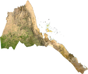 |
Eritrea is mostly covered in Sahel in the north east savanna and desert Desert A desert is a landscape or region that receives an extremely low amount of precipitation, less than enough to support growth of most plants. Most deserts have an average annual precipitation of less than... in the south west. There is a desert strip along Red Sea Red Sea The Red Sea is a seawater inlet of the Indian Ocean, lying between Africa and Asia. The connection to the ocean is in the south through the Bab el Mandeb strait and the Gulf of Aden. In the north, there is the Sinai Peninsula, the Gulf of Aqaba, and the Gulf of Suez... coast, cooler and wetter central highlands and semiarid in western hills and lowlands. The climate Climate Climate encompasses the statistics of temperature, humidity, atmospheric pressure, wind, rainfall, atmospheric particle count and other meteorological elemental measurements in a given region over long periods... is temperate in the mountains and hot in the lowlands. |
111.7 | Sahel |
| Ethiopia Ethiopia Ethiopia , officially known as the Federal Democratic Republic of Ethiopia, is a country located in the Horn of Africa. It is the second-most populous nation in Africa, with over 82 million inhabitants, and the tenth-largest by area, occupying 1,100,000 km2... |
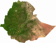 |
Ethiopia has a vast highland complex of mountains, ranging from steep hills in Tigray to the dissected central and western plateaus that are generally divided diagonally southwest to northeast by the Great Rift Valley Great Rift Valley The Great Rift Valley is a name given in the late 19th century by British explorer John Walter Gregory to the continuous geographic trench, approximately in length, that runs from northern Syria in Southwest Asia to central Mozambique in South East Africa... , which is surrounded by lowlands, steppe Steppe In physical geography, steppe is an ecoregion, in the montane grasslands and shrublands and temperate grasslands, savannas, and shrublands biomes, characterized by grassland plains without trees apart from those near rivers and lakes... s, or semi-desert. The eastern Ogaden Ogaden Ogaden is the name of a territory comprising the southeastern portion of the Somali Regional State in Ethiopia. The inhabitants are predominantly ethnic Somali and Muslim. The title "Somali Galbeed", which means "Western Somalia," is often preferred by Somali irredentists.The region, which is... region is mostly a desert, the north is mostly Sahel and savanna, the central plateaus are mostly East Sudanian savanna East Sudanian savanna The East Sudanian Savanna is a hot, dry, tropical savanna ecoregion of central Africa.-Location and description:This is the eastern half of the broad savanna belt which runs east and west across Africa, this section lying east of the Cameroon Highlands... or tropical savanna, while the south, west and parts of Tigray contain East Sudanese savanna, tropical savanna and some patches tropical forests. Xeric grasslands Ethiopian xeric grasslands and shrublands The Ethiopian xeric grasslands and shrublands ecoregion is a semi-desert strip on or near the Red Sea and the Gulf of Oman coasts in Eritrea, Ethiopia, Djibouti and Somaliland.-Location and description:... occur in most regions to. |
194.0 | No |
| Sudan Sudan Sudan , officially the Republic of the Sudan , is a country in North Africa, sometimes considered part of the Middle East politically. It is bordered by Egypt to the north, the Red Sea to the northeast, Eritrea and Ethiopia to the east, South Sudan to the south, the Central African Republic to the... and Southern Sudan |
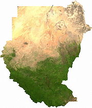 |
Sudan Sudan Sudan , officially the Republic of the Sudan , is a country in North Africa, sometimes considered part of the Middle East politically. It is bordered by Egypt to the north, the Red Sea to the northeast, Eritrea and Ethiopia to the east, South Sudan to the south, the Central African Republic to the... straddles the Sahara, with only the Nile Valley and the small costal region being available to agriculture, while South Sudan South Sudan South Sudan , officially the Republic of South Sudan, is a landlocked country located in the Sahel region of northeastern Africa. It is also part of the North Africa UN sub-region. Its current capital is Juba, which is also its largest city; the capital city is planned to be moved to the more... has got more tropical savanna and Sahel Sahel The Sahel is the ecoclimatic and biogeographic zone of transition between the Sahara desert in the North and the Sudanian Savannas in the south.It stretches across the North African continent between the Atlantic Ocean and the Red Sea.... ecoregion Ecoregion An ecoregion , sometimes called a bioregion, is an ecologically and geographically defined area that is smaller than an ecozone and larger than an ecosystem. Ecoregions cover relatively large areas of land or water, and contain characteristic, geographically distinct assemblages of natural... s. The Sudd Sudd The Sudd , also known as the Bahr al Jabal, As Sudd or Al Sudd, is a vast swamp in South Sudan, formed by the White Nile. The word “sudd” is derived from the Arabic word “sadd”, meaning “block.” The term has come to refer to any large solid floating vegetation island or mat... flood plain lies in the south Water levels fluctuate up to 1.5 meters, depending on the intensity of seasonal flooding. and is mostly Sudanian savanna Sudanian Savanna The Sudanian Savanna is a broad belt of tropical savanna that runs east and west across the African continent, from the Atlantic Ocean in the west to the Ethiopian Highlands in the east. The Sahel, a belt of drier grasslands and acacia savannas, lies to the north, between the Sudanian Savanna and... and sahel. |
43.7joint figure for both | Sahel for the southern part, no for the northern part. |
| Kenya Kenya Kenya , officially known as the Republic of Kenya, is a country in East Africa that lies on the equator, with the Indian Ocean to its south-east... |
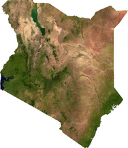 |
The climate varies from mostly cool every day on the coast, to always warm to hot in the interior. The northern region is subject to desertification Desertification Desertification is the degradation of land in drylands. Caused by a variety of factors, such as climate change and human activities, desertification is one of the most significant global environmental problems.-Definitions:... . The hot, arid interior climate is nearly devoid of rainfall, and temperature swing widely, with the overnight low temperatures near sea level Sea level Mean sea level is a measure of the average height of the ocean's surface ; used as a standard in reckoning land elevation... being nearly the same as the high temperatures of the elevated Kenyan highlands. Places on the tropical Indian Ocean Indian Ocean The Indian Ocean is the third largest of the world's oceanic divisions, covering approximately 20% of the water on the Earth's surface. It is bounded on the north by the Indian Subcontinent and Arabian Peninsula ; on the west by eastern Africa; on the east by Indochina, the Sunda Islands, and... coastline, like Mombassa have more moderate temperatures, where the cool air flow in to the hot inland. This means coastal rainfall and temperatures are higher throughout the year. On the higher mountains, such as Mount Kenya Mount Kenya Mount Kenya is the highest mountain in Kenya and the second-highest in Africa, after Kilimanjaro. The highest peaks of the mountain are Batian , Nelion and Point Lenana . Mount Kenya is located in central Kenya, just south of the equator, around north-northeast of the capital Nairobi... , Mount Elgon Mount Elgon Mount Elgon is an extinct shield volcano on the border of Uganda and Kenya, north of Kisumu and west of Kitale.- Physical features :It is the oldest and largest solitary volcano in East Africa, covering an area of around 3500 km².... and Kilimanjaro, the weather can become bitter cold for most of the year and sometimes snowy. |
174.1 | No |
| Uganda Uganda Uganda , officially the Republic of Uganda, is a landlocked country in East Africa. Uganda is also known as the "Pearl of Africa". It is bordered on the east by Kenya, on the north by South Sudan, on the west by the Democratic Republic of the Congo, on the southwest by Rwanda, and on the south by... |
 |
It is in the heart of the Great Lakes region, and is surrounded by three of them, Lake Edward Lake Edward Lake Edward or Edward Nyanza is the smallest of the African Great Lakes. It is located in the western Great Rift Valley, on the border between the Democratic Republic of the Congo and Uganda, with its northern shore a few kilometres south of the Equator... , Lake Albert, and Lake Victoria Lake Victoria Lake Victoria is one of the African Great Lakes. The lake was named for Queen Victoria of the United Kingdom, by John Hanning Speke, the first European to discover this lake.... . While much of its border is lakeshore, Uganda is landlocked Landlocked A landlocked country is a country entirely enclosed by land, or whose only coastlines lie on closed seas. There are 48 landlocked countries in the world, including partially recognized states... with no access to the sea. Despite being on the equator Equator An equator is the intersection of a sphere's surface with the plane perpendicular to the sphere's axis of rotation and containing the sphere's center of mass.... Uganda is more temperate than the surrounding areas due to its altitude. The country is mostly plateau with a rim of mountains. This has made it more suitable to agriculture and less prone to tropical diseases than other nations in the region. The climate is tropical; generally rainy with two dry seasons (December to February, June to August). It is semiarid East Sudanian savanna East Sudanian savanna The East Sudanian Savanna is a hot, dry, tropical savanna ecoregion of central Africa.-Location and description:This is the eastern half of the broad savanna belt which runs east and west across Africa, this section lying east of the Cameroon Highlands... in north near Sudan Sudan Sudan , officially the Republic of the Sudan , is a country in North Africa, sometimes considered part of the Middle East politically. It is bordered by Egypt to the north, the Red Sea to the northeast, Eritrea and Ethiopia to the east, South Sudan to the south, the Central African Republic to the... . |
355.2 | No |
| Chad Chad Chad , officially known as the Republic of Chad, is a landlocked country in Central Africa. It is bordered by Libya to the north, Sudan to the east, the Central African Republic to the south, Cameroon and Nigeria to the southwest, and Niger to the west... |
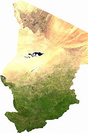 |
Chad is divided into three distinct zones, from the Sudanese savanna in the south, the Sahel Sahel The Sahel is the ecoclimatic and biogeographic zone of transition between the Sahara desert in the North and the Sudanian Savannas in the south.It stretches across the North African continent between the Atlantic Ocean and the Red Sea.... in the central belt and the Sahara Sahara The Sahara is the world's second largest desert, after Antarctica. At over , it covers most of Northern Africa, making it almost as large as Europe or the United States. The Sahara stretches from the Red Sea, including parts of the Mediterranean coasts, to the outskirts of the Atlantic Ocean... Desert in the north. The most fertile land is around the steadily shrinking Lake Chad Lake Chad Lake Chad is a historically large, shallow, endorheic lake in Africa, whose size has varied over the centuries. According to the Global Resource Information Database of the United Nations Environment Programme, it shrank as much as 95% from about 1963 to 1998; yet it also states that "the 2007 ... . |
20.8 | Sahel and CILLS |
| Central African Republic Central African Republic The Central African Republic , is a landlocked country in Central Africa. It borders Chad in the north, Sudan in the north east, South Sudan in the east, the Democratic Republic of the Congo and the Republic of the Congo in the south, and Cameroon in the west. The CAR covers a land area of about ,... |
The climate of the C.A.R. is generally tropical Tropics The tropics is a region of the Earth surrounding the Equator. It is limited in latitude by the Tropic of Cancer in the northern hemisphere at approximately N and the Tropic of Capricorn in the southern hemisphere at S; these latitudes correspond to the axial tilt of the Earth... . The northern areas are subject to harmattan Harmattan The Harmattan is a dry and dusty West African trade wind. It blows south from the Sahara into the Gulf of Guinea between the end of November and the middle of March... winds, which are hot, dry, and carry dust. The northern regions have been subject to desertification Desertification Desertification is the degradation of land in drylands. Caused by a variety of factors, such as climate change and human activities, desertification is one of the most significant global environmental problems.-Definitions:... , and the northeast is a desert. The remainder of the country is prone to flooding from nearby rivers as much of the southern border is formed by tributaries of the Congo River Congo River The Congo River is a river in Africa, and is the deepest river in the world, with measured depths in excess of . It is the second largest river in the world by volume of water discharged, though it has only one-fifth the volume of the world's largest river, the Amazon... , with the Mbomou River Mbomou River The Mbomou River or Bomu forms part of the boundary between the Central African Republic and the Democratic Republic of the Congo .... in the east merging with the Uele River Uele River The Uele River, also spelled Welle River, is a river in the Democratic Republic of the Congo. It originates in the mountains near Lake Albert and flows west for about to join the Mbomou River at Yakoma.... to form the Ubangi River Ubangi River The Ubangi River , also spelled Oubangui, is the largest right-bank tributary of the Congo River of Central Africa. It begins at the confluence of the Mbomou and Uele Rivers and flows west, then bends to the southwest and passes through Bangui, after which it flows south to the Congo at Liranga.... . In the west, the Sangha River Sangha River The Sangha River, a river in central Africa, is a tributary of the Congo River, which it joins at . Formed by the merging of the Mambéré River into the Kadéï River at Nola , the Sangha flows through the Central African Republic, along the border of Cameroon, and through the Republic of Congo.Its... flows through part of the country. The eastern border lies along the edge of the Nile river watershed Drainage basin A drainage basin is an extent or an area of land where surface water from rain and melting snow or ice converges to a single point, usually the exit of the basin, where the waters join another waterbody, such as a river, lake, reservoir, estuary, wetland, sea, or ocean... . The estimated amount of the country covered by forest ranges up to 8%, with the densest parts in the south. It is highly diverse, and includes commercially important species of Ayous, Sapelli Sapele Sapele , also known as Sapelli or Aboudikro, is a large tree, Entandrophragma cylindricum, up to 45 m high and native to tropical Africa. The leaves are deciduous in the dry season, alternately arranged, pinnate, with 5-9 pairs of leaflets, each leaflet about 10 cm long... and Sipo. The deforestation rate is 0.4% per annum, and lumber poaching is commonplace. |
18.4 | No | |
| Cameroon Cameroon Cameroon, officially the Republic of Cameroon , is a country in west Central Africa. It is bordered by Nigeria to the west; Chad to the northeast; the Central African Republic to the east; and Equatorial Guinea, Gabon, and the Republic of the Congo to the south. Cameroon's coastline lies on the... |
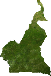 |
The climate varies with the terrain. The climate is exceedingly hot and humid, the coastal belt includes some of the wettest places on earth. For example, Debundscha Debundscha Debundscha is a village in the Southwestern Region, of the republic of Cameroon. It is found at the foot of the Mount Cameroon,at its south western slope, directly facing the south Atlantic ocean on the Cameroon coast.... , at the base of Mt. Cameroon, has an average annual rainfall of 405 inches (10,287 mm). The coastal plain extends 15 to 150 km (9.3 to 93.2 mi) inland from the Gulf of Guinea and has an average elevation of 90 metres (295 ft). Exceedingly hot and humid with a short dry season Dry season The dry season is a term commonly used when describing the weather in the tropics. The weather in the tropics is dominated by the tropical rain belt, which oscillates from the northern to the southern tropics over the course of the year... , this belt is densely forested and includes some of the wettest places on earth, part of the Cross-Sanaga-Bioko coastal forests Cross-Sanaga-Bioko coastal forests The Cross-Sanaga-Bioko coastal forests are a tropical moist broadleaf forest ecoregion of west-central Africa. This is lush forest rich in flora and birdlife.-Location and description:... . The South Cameroon Plateau South Cameroon Plateau The South Cameroon Plateau or Southern Cameroon Plateau is the dominant geographical feature of Cameroon. The plateau lies south of the Adamawa Plateau and southeast of the Cameroon Range. It slopes south and west until giving way to the Cameroon coastal plain in the southwest and the Congo River... rises from the coastal plain to an average elevation of 650 metres (2,133 ft). Equatorial rainforest dominates this region, although its alternation between wet Wet season The the wet season, or rainy season, is the time of year, covering one or more months, when most of the average annual rainfall in a region occurs. The term green season is also sometimes used as a euphemism by tourist authorities. Areas with wet seasons are dispersed across portions of the... and dry seasons makes it is less humid than the coast. This area is part of the Atlantic Equatorial coastal forests Atlantic Equatorial coastal forests The Atlantic Equatorial coastal forests are a tropical moist broadleaf forest ecoregion of central Africa, covering hills, plains, and mountains of the Atlantic coast of Cameroon, Equatorial Guinea, Gabon, Republic of the Congo, Angola, and Democratic Republic of the Congo.This is rich forest home... ecoregion Ecoregion An ecoregion , sometimes called a bioregion, is an ecologically and geographically defined area that is smaller than an ecozone and larger than an ecosystem. Ecoregions cover relatively large areas of land or water, and contain characteristic, geographically distinct assemblages of natural... . An irregular chain of mountains, hills, and plateaus known as the Cameroon range Cameroon line The Cameroon line is a chain of volcanoes.It includes islands in the Gulf of Guinea and mountains that extend along the border region of eastern Nigeria and western Cameroon, from Mount Cameroon on the Gulf of Guinea north and east towards Lake Chad.... extends from Mount Cameroon Mount Cameroon Mount Cameroon is an active volcano in Cameroon near the Gulf of Guinea. Mount Cameroon is also known as Cameroon Mountain or Fako or by its native name Mongo ma Ndemi .... on the coast—Cameroon's highest point at 4095 metres (13,435 ft)—almost to Lake Chad Lake Chad Lake Chad is a historically large, shallow, endorheic lake in Africa, whose size has varied over the centuries. According to the Global Resource Information Database of the United Nations Environment Programme, it shrank as much as 95% from about 1963 to 1998; yet it also states that "the 2007 ... at Cameroon's northern tip. This region has a mild climate, particularly on the Western High Plateau Western High Plateau The Western High Plateau, Western Highlands, or Bamenda Grassfields is a region of Cameroon characterised by high relief, cool temperatures, heavy rainfall, and savanna vegetation. The region lies along the Cameroon line and consists of mountain ranges and volcanoes made of crystalline and igneous... , although rainfall is high. Its soils are among Cameroon's most fertile, especially around volcanic Mount Cameroon. Volcanism here has created the crater lake Crater lake A crater lake is a lake that forms in a volcanic crater or caldera, such as a maar; less commonly and with lower association to the term a lake may form in an impact crater caused by a meteorite. Sometimes lakes which form inside calderas are called caldera lakes, but often this distinction is not... s, like Lake Nyos Lake Nyos Lake Nyos is a crater lake in the Northwest Region of Cameroon, located about northwest of Yaoundé. Nyos is a deep lake high on the flank of an inactive volcano in the Oku volcanic plain along the Cameroon line of volcanic activity... of the Cameroonian Highlands forests Cameroonian Highlands forests The Cameroonian Highlands forests are a montane tropical moist broadleaf forest ecoregion located on the range of mountains that runs inland from the Gulf of Guinea and forms the border between Cameroon and Nigeria... ecoregion Ecoregion An ecoregion , sometimes called a bioregion, is an ecologically and geographically defined area that is smaller than an ecozone and larger than an ecosystem. Ecoregions cover relatively large areas of land or water, and contain characteristic, geographically distinct assemblages of natural... . The southern plateau rises northward to the grassy, rugged Adamawa Plateau Adamawa Plateau The Adamawa Plateau is a plateau region in west-central Africa stretching from south-eastern Nigeria through north-central Cameroon to the Central African Republic. The plateau was named after Fulani Muslim leader Modibo Adama. The part of the plateau that lies in Nigeria is more popularly known... . This feature stretches from the western mountain area and forms a barrier between the country's north and south. Its average elevation is 1100 metres (3,609 ft), and its temperature ranges from 22 °C (71.6 °F) to 25 °C (77 °F) with high rainfall. The northern lowland region East Sudanian savanna The East Sudanian Savanna is a hot, dry, tropical savanna ecoregion of central Africa.-Location and description:This is the eastern half of the broad savanna belt which runs east and west across Africa, this section lying east of the Cameroon Highlands... extends from the edge of the Adamawa to Lake Chad with an average elevation of 300 to 350 m (984.3 to 1,148.3 ft). Its characteristic vegetation is savanna scrub and grass. This is an arid region with sparse rainfall and high median temperatures. |
102.8 | No |
| Nigeria Nigeria Nigeria , officially the Federal Republic of Nigeria, is a federal constitutional republic comprising 36 states and its Federal Capital Territory, Abuja. The country is located in West Africa and shares land borders with the Republic of Benin in the west, Chad and Cameroon in the east, and Niger in... |
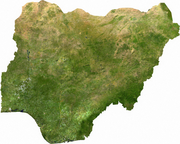 |
Nigeria is covered by rainforests over the southern third, Guinean forest-savanna mosaic Guinean forest-savanna mosaic The Guinean forest-savanna mosaic is an ecoregion of West Africa, a band of interlaced forest, savanna, and grassland running east to west and dividing the tropical moist forests near the coast from the West Sudanian savanna of the interior.-Setting:... in the middle third and both savannas and Sahel in the northern third. The mountain Mountain Image:Himalaya_annotated.jpg|thumb|right|The Himalayan mountain range with Mount Everestrect 58 14 160 49 Chomo Lonzorect 200 28 335 52 Makalurect 378 24 566 45 Mount Everestrect 188 581 920 656 Tibetan Plateaurect 250 406 340 427 Rong River... land is also found in the mountains near the Cameroonian border.. The most southerly part of the forest, especially around the Niger River Niger River The Niger River is the principal river of western Africa, extending about . Its drainage basin is in area. Its source is in the Guinea Highlands in southeastern Guinea... and Cross River Cross River (Nigeria) Cross River is the main river in southeastern Nigeria and gives its name to Cross River State.It originates in Cameroon, where it takes the name of the Manyu River.... deltas, is mangrove Mangrove Mangroves are various kinds of trees up to medium height and shrubs that grow in saline coastal sediment habitats in the tropics and subtropics – mainly between latitudes N and S... swamp (see Central African mangroves Central African mangroves The Central African mangroves ecoregion consists of the largest area of mangrove swamp in Africa, located on the coasts of West Africa, mainly in Nigeria.-Location and description:... ). North of this is fresh water swamp, containing different vegetation from the salt water mangrove swamps, and north of that is rain forest. |
433.8 | Sahel |
| Niger Niger Niger , officially named the Republic of Niger, is a landlocked country in Western Africa, named after the Niger River. It borders Nigeria and Benin to the south, Burkina Faso and Mali to the west, Algeria and Libya to the north and Chad to the east... |
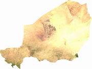 |
Niger's subtropical climate is mainly very hot and dry. Niger is located mostly in the Sahara Sahara The Sahara is the world's second largest desert, after Antarctica. At over , it covers most of Northern Africa, making it almost as large as Europe or the United States. The Sahara stretches from the Red Sea, including parts of the Mediterranean coasts, to the outskirts of the Atlantic Ocean... desert Desert A desert is a landscape or region that receives an extremely low amount of precipitation, less than enough to support growth of most plants. Most deserts have an average annual precipitation of less than... save for a small peace of tropical savanna around the River Niger basin. Some flat to rolling savanna and Sahel Sahel The Sahel is the ecoclimatic and biogeographic zone of transition between the Sahara desert in the North and the Sudanian Savannas in the south.It stretches across the North African continent between the Atlantic Ocean and the Red Sea.... land is in the southern most fifth of its territory and in the northern hills. |
31.2 | Sahel Sahel The Sahel is the ecoclimatic and biogeographic zone of transition between the Sahara desert in the North and the Sudanian Savannas in the south.It stretches across the North African continent between the Atlantic Ocean and the Red Sea.... and CILLS |
| Burkina Faso Burkina Faso Burkina Faso – also known by its short-form name Burkina – is a landlocked country in west Africa. It is surrounded by six countries: Mali to the north, Niger to the east, Benin to the southeast, Togo and Ghana to the south, and Côte d'Ivoire to the southwest.Its size is with an estimated... |
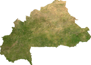 |
A relatively dry tropical savanna, the Sahel extends beyond the borders of Burkina Faso, from the Horn of Africa Horn of Africa The Horn of Africa is a peninsula in East Africa that juts hundreds of kilometers into the Arabian Sea and lies along the southern side of the Gulf of Aden. It is the easternmost projection of the African continent... to the Atlantic Ocean Atlantic Ocean The Atlantic Ocean is the second-largest of the world's oceanic divisions. With a total area of about , it covers approximately 20% of the Earth's surface and about 26% of its water surface area... , and borders the Sahara Sahara The Sahara is the world's second largest desert, after Antarctica. At over , it covers most of Northern Africa, making it almost as large as Europe or the United States. The Sahara stretches from the Red Sea, including parts of the Mediterranean coasts, to the outskirts of the Atlantic Ocean... to its north and the fertile region of the Sudan Sudan (region) The Sudan is the name given to a geographic region to the south of the Sahara, stretching from Western to Eastern Africa. The name derives from the Arabic bilâd as-sûdân or "land of the Blacks"... to the South. Situated at a middle latitude Latitude In geography, the latitude of a location on the Earth is the angular distance of that location south or north of the Equator. The latitude is an angle, and is usually measured in degrees . The equator has a latitude of 0°, the North pole has a latitude of 90° north , and the South pole has a... is the Sudan-Sahel region, a transitional zone for rainfall and temperature levels. Further to the south, the Sudan-Guinea zone receives more than heavy rain each year and has cooler temperatures. The northern fringes of the country are beginning to become a desert. |
148.9 | Sahel and CILLS |
| Côte d'Ivoire Côte d'Ivoire The Republic of Côte d'Ivoire or Ivory Coast is a country in West Africa. It has an area of , and borders the countries Liberia, Guinea, Mali, Burkina Faso and Ghana; its southern boundary is along the Gulf of Guinea. The country's population was 15,366,672 in 1998 and was estimated to be... /Ivory Coast |
Côte d'Ivoire's terrain Terrain Terrain, or land relief, is the vertical and horizontal dimension of land surface. When relief is described underwater, the term bathymetry is used... can generally be described as a large plateau Plateau In geology and earth science, a plateau , also called a high plain or tableland, is an area of highland, usually consisting of relatively flat terrain. A highly eroded plateau is called a dissected plateau... rising gradually from sea level Sea level Mean sea level is a measure of the average height of the ocean's surface ; used as a standard in reckoning land elevation... in the south to almost 500 m elevation Elevation The elevation of a geographic location is its height above a fixed reference point, most commonly a reference geoid, a mathematical model of the Earth's sea level as an equipotential gravitational surface .... in the north. In the south of Côte d'Ivoire is marked by coastal inland lagoons that starts at the Ghanaian border and stretch 300 km (186 mi) along the eastern half of the coast. The south and southwest of the country are covered with dense tropical moist forest like the Eastern Guinean forests Eastern Guinean forests The Eastern Guinean forests are a tropical moist broadleaf forest ecoregion of West Africa. The ecoregion includes the lowland forests extending from the Gulf of Guinea a few hundred kilometers inland, from western Côte d'Ivoire to the western shore of Lake Volta in Ghana. A few small enclaves lie... and Western Guinean lowland forests Western Guinean lowland forests The Western Guinean lowland forests are a tropical moist broadleaf forest ecoregion of West Africa. The ecoregion includes the lowland forests extending from the Atlantic Ocean a few hundred kilometers inland, and from western Côte d'Ivoire across Liberia, southeastern Guinea, most of Sierra Leone,... that cross the Sassandra River Sassandra River The Sassandra River is a river of western Côte d'Ivoire in West Africa. It is formed by the confluence of the Tienba River, which originates in the highlands of northwestern Côte d'Ivoire, and the Gouan River , which originates to the west in the highlands of Guinea... . The mountains of Dix-Huit Montagnes Dix-Huit Montagnes Dix-Huit Montagnes is one of the 19 regions of Côte d'Ivoire. The region's capital is Man. Covering 16,600 km², its population is 1,125,800.... region are home to the Guinean montane forests. The Guinean forest-savanna mosaic Guinean forest-savanna mosaic The Guinean forest-savanna mosaic is an ecoregion of West Africa, a band of interlaced forest, savanna, and grassland running east to west and dividing the tropical moist forests near the coast from the West Sudanian savanna of the interior.-Setting:... belt extends across the middle of the country from east to west. The North is part of the West Sudanian savanna, a savanna Tropical and subtropical grasslands, savannas, and shrublands Tropical and subtropical grasslands, savannas, and shrublands are a grassland terrestrial biome located in semi-arid to semi-humid climate regions of subtropical and tropical latitudes. Grasslands are dominated by grass and other herbaceous plants. Savannas are grasslands with scattered trees... -and-scrubland zone of lateritic or sandy soil Soil Soil is a natural body consisting of layers of mineral constituents of variable thicknesses, which differ from the parent materials in their morphological, physical, chemical, and mineralogical characteristics... s, with vegetation Vegetation Vegetation is a general term for the plant life of a region; it refers to the ground cover provided by plants. It is a general term, without specific reference to particular taxa, life forms, structure, spatial extent, or any other specific botanical or geographic characteristics. It is broader... decreasing from south to north. The terrain is mostly flat to undulating plain Plain In geography, a plain is land with relatively low relief, that is flat or gently rolling. Prairies and steppes are types of plains, and the archetype for a plain is often thought of as a grassland, but plains in their natural state may also be covered in shrublands, woodland and forest, or... s, with mountain Mountain Image:Himalaya_annotated.jpg|thumb|right|The Himalayan mountain range with Mount Everestrect 58 14 160 49 Chomo Lonzorect 200 28 335 52 Makalurect 378 24 566 45 Mount Everestrect 188 581 920 656 Tibetan Plateaurect 250 406 340 427 Rong River... s in the northwest. The climate Climate Climate encompasses the statistics of temperature, humidity, atmospheric pressure, wind, rainfall, atmospheric particle count and other meteorological elemental measurements in a given region over long periods... of Côte d'Ivoire is generally warm and humid, ranging from equator Equator An equator is the intersection of a sphere's surface with the plane perpendicular to the sphere's axis of rotation and containing the sphere's center of mass.... ial in the southern coasts to tropical Tropics The tropics is a region of the Earth surrounding the Equator. It is limited in latitude by the Tropic of Cancer in the northern hemisphere at approximately N and the Tropic of Capricorn in the southern hemisphere at S; these latitudes correspond to the axial tilt of the Earth... in the middle and semiarid in the far north. There are three seasons: warm and dry (November to March), hot and dry (March to May), and hot and wet (June to October). Temperatures average between 25 and 32 °C (77 and 89.6 °F) and range from 10 to 40 °C (50 to 104 °F). |
165.6 | No | |
| Mali Mali Mali , officially the Republic of Mali , is a landlocked country in Western Africa. Mali borders Algeria on the north, Niger on the east, Burkina Faso and the Côte d'Ivoire on the south, Guinea on the south-west, and Senegal and Mauritania on the west. Its size is just over 1,240,000 km² with... |
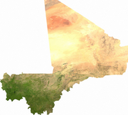 |
About two-thirds of Mali is located in the Sahara Sahara The Sahara is the world's second largest desert, after Antarctica. At over , it covers most of Northern Africa, making it almost as large as Europe or the United States. The Sahara stretches from the Red Sea, including parts of the Mediterranean coasts, to the outskirts of the Atlantic Ocean... desert Desert A desert is a landscape or region that receives an extremely low amount of precipitation, less than enough to support growth of most plants. Most deserts have an average annual precipitation of less than... , exempt for the south eastern third, which contains both a Sahel Sahel The Sahel is the ecoclimatic and biogeographic zone of transition between the Sahara desert in the North and the Sudanian Savannas in the south.It stretches across the North African continent between the Atlantic Ocean and the Red Sea.... zone and fertile tropical savanna around the River Niger. |
30.3 | Sahel, CILLS and Sénégal River Area |
| Algeria Algeria Algeria , officially the People's Democratic Republic of Algeria , also formally referred to as the Democratic and Popular Republic of Algeria, is a country in the Maghreb region of Northwest Africa with Algiers as its capital.In terms of land area, it is the largest country in Africa and the Arab... |
 |
The coastal quarter has a Mediterranean climate, while the rest is either a sandy desert or semi-desert on the interior's few hills. There is a strip of Sahel running trough the far south and the climate is cooler in the mountain regions | 37.1 | Sahel |
| Mauritania Mauritania Mauritania is a country in the Maghreb and West Africa. It is bordered by the Atlantic Ocean in the west, by Western Sahara in the north, by Algeria in the northeast, by Mali in the east and southeast, and by Senegal in the southwest... |
 |
Mauritania is located mostly in the Sahara Sahara The Sahara is the world's second largest desert, after Antarctica. At over , it covers most of Northern Africa, making it almost as large as Europe or the United States. The Sahara stretches from the Red Sea, including parts of the Mediterranean coasts, to the outskirts of the Atlantic Ocean... desert Desert A desert is a landscape or region that receives an extremely low amount of precipitation, less than enough to support growth of most plants. Most deserts have an average annual precipitation of less than... save for a small piece of tropical savanna and Sahel Sahel The Sahel is the ecoclimatic and biogeographic zone of transition between the Sahara desert in the North and the Sudanian Savannas in the south.It stretches across the North African continent between the Atlantic Ocean and the Red Sea.... around the River Senegal in approximately the southern most quarter of its territory. Because of extended, severe drought Drought A drought is an extended period of months or years when a region notes a deficiency in its water supply. Generally, this occurs when a region receives consistently below average precipitation. It can have a substantial impact on the ecosystem and agriculture of the affected region... , the desert Desert A desert is a landscape or region that receives an extremely low amount of precipitation, less than enough to support growth of most plants. Most deserts have an average annual precipitation of less than... has been expanding since the mid-1960s. To the west, between the ocean and the eastern plateaus, are alternating areas of clayey plains and sand dunes, some of which are shifted from place to place by high winds. |
8.2 | Sahel state, CILLS and Sénégal River Area |
| Senegal Senegal Senegal , officially the Republic of Senegal , is a country in western Africa. It owes its name to the Sénégal River that borders it to the east and north... |
Senegal has a both Sahel Sahel The Sahel is the ecoclimatic and biogeographic zone of transition between the Sahara desert in the North and the Sudanian Savannas in the south.It stretches across the North African continent between the Atlantic Ocean and the Red Sea.... , Sahel-Soudan, Sudan (region) Sudan Sudan , officially the Republic of the Sudan , is a country in North Africa, sometimes considered part of the Middle East politically. It is bordered by Egypt to the north, the Red Sea to the northeast, Eritrea and Ethiopia to the east, South Sudan to the south, the Central African Republic to the... , Soudan-Guinea, tropical rainforest Tropical rainforest A tropical rainforest is an ecosystem type that occurs roughly within the latitudes 28 degrees north or south of the equator . This ecosystem experiences high average temperatures and a significant amount of rainfall... , and Guinean mangroves Guinean mangroves The Guinean mangroves are a coastal ecoregion of mangrove swamps in rivers and estuaries near the ocean of West Africa from Senegal to Sierra Leone.-Location and description:... . Most of the southern Casamance Casamance Casamance is the area of Senegal south of The Gambia including the Casamance River. It consists of Basse Casamance and Haute Casamance... arm of the country has been classified by the World Wildlife Fund as part of the Guinean forest-savanna mosaic Guinean forest-savanna mosaic The Guinean forest-savanna mosaic is an ecoregion of West Africa, a band of interlaced forest, savanna, and grassland running east to west and dividing the tropical moist forests near the coast from the West Sudanian savanna of the interior.-Setting:... ecoregion Ecoregion An ecoregion , sometimes called a bioregion, is an ecologically and geographically defined area that is smaller than an ecozone and larger than an ecosystem. Ecoregions cover relatively large areas of land or water, and contain characteristic, geographically distinct assemblages of natural... . |
180.4 | Sahel state, CILLS and Sénégal River Area | |
| Gambia | 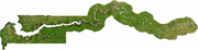 |
The Gambia has a subtropical climate with distinct cool, dry and hot, humid seasons. The temperature escalates rapidly on going inland and has been known to reach as high as 51C on occasions. The average annual rainfall ranges from 920 mm (36.2 in) in the interior to 1450 mm (57.1 in) along the coast. The grassy flood plain of the Gambia River, which contains Guinean mangroves Guinean mangroves The Guinean mangroves are a coastal ecoregion of mangrove swamps in rivers and estuaries near the ocean of West Africa from Senegal to Sierra Leone.-Location and description:... near the coast, with West Sudanian savanna upriver and inland. |
425.5 | CILLS and Sénégal River Area (observer member). |
| Guinea Guinea Guinea , officially the Republic of Guinea , is a country in West Africa. Formerly known as French Guinea , it is today sometimes called Guinea-Conakry to distinguish it from its neighbour Guinea-Bissau. Guinea is divided into eight administrative regions and subdivided into thirty-three prefectures... |
 |
Guinea Guinea Guinea , officially the Republic of Guinea , is a country in West Africa. Formerly known as French Guinea , it is today sometimes called Guinea-Conakry to distinguish it from its neighbour Guinea-Bissau. Guinea is divided into eight administrative regions and subdivided into thirty-three prefectures... has both lowland belt running north to south behind the coast (Lower Guinea Lower Guinea Lower Guinea can refer to the coastal part of either* the Republic of Guinea* the wider Guinea region-See also:*Lower Guinean forests*Middle Guinea*Upper Guinea... ), which is part of the Guinean forest-savanna mosaic Guinean forest-savanna mosaic The Guinean forest-savanna mosaic is an ecoregion of West Africa, a band of interlaced forest, savanna, and grassland running east to west and dividing the tropical moist forests near the coast from the West Sudanian savanna of the interior.-Setting:... ecoregion; the pastoral Fouta Djallon Fouta Djallon Fouta Djallon is a highland region in the centre of Guinea, West Africa. The indigenous name is Fuuta-Jaloo... highlands (Middle Guinea Middle Guinea Middle Guinea refers to the central part of the Republic of Guinea.... ); the northern fertile Fertile The term fertile describes a condition whereby organisms are able to produce physically healthy offspring.Fertile may also refer to:... (Upper Guinea Upper Guinea Upper Guinea or la Haute-Guinée is a large plain covering eastern Guinea, Sierra Leone, Liberia and extending into north western Côte d'Ivoire. Mostly forming the upper watershed of the River Niger, it is sparsely populated and is home to the Haut Niger National Park.Upper Guinea can also refer to... ); and a south-eastern rain-forest region (Forest Guinea). |
106.1 | Sahel state, CILLS and Sénégal River Area |
| Guinea Bissau | The climate in Guinea-Bissau is tropical and is generally hot and humid. It has a monsoonal-type rainy season with southwesterly winds and a dry season with northeasterly Harmattan Harmattan The Harmattan is a dry and dusty West African trade wind. It blows south from the Sahara into the Gulf of Guinea between the end of November and the middle of March... winds. It is warm all year around and there is little temperature fluctuation; it averages 26.3 °C (79.3 °F). The average rainfall for Bissau is 2024 millimetres (79.7 in) although this is almost entirely accounted for during the rainy season which falls between June and September/October. From December through April, the country experiences drought Drought A drought is an extended period of months or years when a region notes a deficiency in its water supply. Generally, this occurs when a region receives consistently below average precipitation. It can have a substantial impact on the ecosystem and agriculture of the affected region... . The terrain of Guinea-Bissau is mostly low coastal plain with swamps of Guinean mangroves Guinean mangroves The Guinean mangroves are a coastal ecoregion of mangrove swamps in rivers and estuaries near the ocean of West Africa from Senegal to Sierra Leone.-Location and description:... rising to Guinean forest-savanna mosaic Guinean forest-savanna mosaic The Guinean forest-savanna mosaic is an ecoregion of West Africa, a band of interlaced forest, savanna, and grassland running east to west and dividing the tropical moist forests near the coast from the West Sudanian savanna of the interior.-Setting:... in the east. |
115.5 | CILLS |
See also
- East Sudanian savannaEast Sudanian savannaThe East Sudanian Savanna is a hot, dry, tropical savanna ecoregion of central Africa.-Location and description:This is the eastern half of the broad savanna belt which runs east and west across Africa, this section lying east of the Cameroon Highlands...
- Sudanese savanna
- 2010 Nigerien floods
- Global storm activity of late 2010
- 2005-06 Niger food crisis2005-06 Niger food crisisA severe but localized food security crisis occurred in the regions of northern Maradi, Tahoua, Tillabéri, and Zinder of Niger from 2005 to 2006. It was caused by an early end to the 2004 rains, desert locust damage to some pasture lands, high food prices, and chronic poverty. In the affected area,...
- Yacouba SawadogoYacouba SawadogoYacouba Sawadogo is a farmer from the west African nation of Burkina Faso who has been successfully using traditional farming techniques from the region to restore soils damaged by desertification and drought.-Background:...
- Green Sahara
- 2009 West Africa floods2009 West Africa floodsThe 2009 West Africa floods are a natural disaster that began in June 2009 as a consequence of exceptionally heavy seasonal rainfall in large areas of West Africa....
- 2006 Horn of Africa food crisis2006 Horn of Africa food crisisIn 2006, an acute shortage of food affected the countries in the Horn of Africa , as well as northeastern Kenya. The United Nations's Food and Agriculture Organization estimated on January 6, 2006, that more than 11 million people in these countries may be affected by an impending widespread...
- 1984-1985 famine in Ethiopia
- Malawian food crisis
- Sahel droughtSahel drought[[File:Greening Sahel 1982-1999.jpg|thumb|300px|Recent "Greening" of the Sahel: The results of trend analyses of time series over the Sahel region of seasonally integrated NDVI using NOAA AVHRR NDVI-data from 1982 to 1999...
- 2010 Khyber Pakhtunkhwa floods
- 2010 Northern Hemisphere summer heat wave
- Severe weather of the Indian subcontinent during 2010
- 2010 Russian wildfires2010 Russian wildfiresThe 2010 Russian wildfires were several hundred wildfires that broke out across Russia, primarily in the west, starting in late July 2010, due to record temperatures and drought in the region...
- Community of Sahel-Saharan StatesCommunity of Sahel-Saharan StatesCEN-SAD or the Community of Sahel-Saharan States aims to create a free trade area...
- Sudan (region)Sudan (region)The Sudan is the name given to a geographic region to the south of the Sahara, stretching from Western to Eastern Africa. The name derives from the Arabic bilâd as-sûdân or "land of the Blacks"...
- Pan Sahel InitiativePan Sahel InitiativeThe Pan-Sahel Initiative, according to a November 7, 2002, by the Office of Counterterrorism, U.S. Department of State, was "a State-led effort to assist Mali, Niger, Chad, and Mauritania in detecting and responding to suspicious movement of people and goods across and within their borders through...
- Sahara Conservation FundSahara Conservation FundThe Sahara Conservation Fund is an international non-governmental organization established in 2004 to conserve the wildlife of the Sahara and bordering Sahelian grasslands...
- Trans-Sahelian HighwayTrans-Sahelian HighwayThe Trans-Sahelian Highway or Trans-Sahel Highway is a transnational highway project to pave, improve and ease border formalities on a highway route through the southern fringes of the Sahel region in West Africa between Dakar, Senegal in the west and Ndjamena, Chad, in the east...
- 2011 Horn of Africa famine