
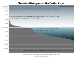
Elevation
Encyclopedia

Location (geography)
The terms location and place in geography are used to identify a point or an area on the Earth's surface or elsewhere. The term 'location' generally implies a higher degree of can certainty than "place" which often has an ambiguous boundary relying more on human/social attributes of place identity...
is its height above a fixed reference point, most commonly a reference geoid
Geoid
The geoid is that equipotential surface which would coincide exactly with the mean ocean surface of the Earth, if the oceans were in equilibrium, at rest , and extended through the continents . According to C.F...
, a mathematical model of the Earth's
Earth
Earth is the third planet from the Sun, and the densest and fifth-largest of the eight planets in the Solar System. It is also the largest of the Solar System's four terrestrial planets...
sea level
Sea level
Mean sea level is a measure of the average height of the ocean's surface ; used as a standard in reckoning land elevation...
as an equipotential
Equipotential
Equipotential or isopotential in mathematics and physics refers to a region in space where every point in it is at the same potential. This usually refers to a scalar potential , although it can also be applied to vector potentials...
gravitational
Gravitation
Gravitation, or gravity, is a natural phenomenon by which physical bodies attract with a force proportional to their mass. Gravitation is most familiar as the agent that gives weight to objects with mass and causes them to fall to the ground when dropped...
surface
Equipotential surface
Equipotential surfaces are surfaces of constant scalar potential. They are used to visualize an -dimensional scalar potential function in dimensional space...
(see Geodetic system, vertical datum).
Elevation, or geometric height, is mainly used when referring to points on the Earth
Earth
Earth is the third planet from the Sun, and the densest and fifth-largest of the eight planets in the Solar System. It is also the largest of the Solar System's four terrestrial planets...
's surface, while altitude
Altitude
Altitude or height is defined based on the context in which it is used . As a general definition, altitude is a distance measurement, usually in the vertical or "up" direction, between a reference datum and a point or object. The reference datum also often varies according to the context...
or geopotential height
Geopotential height
Geopotential height is a vertical coordinate referenced to Earth's mean sea level — an adjustment to geometric height using the variation of gravity with latitude and elevation. Thus it can be considered a "gravity-adjusted height"...
is used for points above the surface, such as an aircraft
Aircraft
An aircraft is a vehicle that is able to fly by gaining support from the air, or, in general, the atmosphere of a planet. An aircraft counters the force of gravity by using either static lift or by using the dynamic lift of an airfoil, or in a few cases the downward thrust from jet engines.Although...
in flight or a spacecraft
Spacecraft
A spacecraft or spaceship is a craft or machine designed for spaceflight. Spacecraft are used for a variety of purposes, including communications, earth observation, meteorology, navigation, planetary exploration and transportation of humans and cargo....
in orbit, and depth
Depth
Depth may refer to:* Depth , an important invariant of rings and modules in commutative and homological algebra* Depth in a well, the measurement between two points in an oil well...
is used for points below the surface.
Less commonly, elevation is measured using the center of the Earth as the reference point. Due to equatorial bulge
Equatorial bulge
An equatorial bulge is a difference between the equatorial and polar diameters of a planet, due to the centrifugal force of its rotation. A rotating body tends to form an oblate spheroid rather than a sphere...
, there is debate as to which of the summits of Mt. Everest
Mount Everest
Mount Everest is the world's highest mountain, with a peak at above sea level. It is located in the Mahalangur section of the Himalayas. The international boundary runs across the precise summit point...
or Chimborazo
Chimborazo (volcano)
Chimborazo is a currently inactive stratovolcano located in the Cordillera Occidental range of the Andes. Its last known eruption is believed to have occurred around 550 AD....
is at the higher elevation, as the Chimborazo summit is further from the Earth's center while the Mt. Everest summit is higher above mean sea level.
Maps and GIS
Topographic map
A topographic map is a type of map characterized by large-scale detail and quantitative representation of relief, usually using contour lines in modern mapping, but historically using a variety of methods. Traditional definitions require a topographic map to show both natural and man-made features...
is the main type of map
Map
A map is a visual representation of an area—a symbolic depiction highlighting relationships between elements of that space such as objects, regions, and themes....
used to depict elevation, often through use of contour line
Contour line
A contour line of a function of two variables is a curve along which the function has a constant value. In cartography, a contour line joins points of equal elevation above a given level, such as mean sea level...
s.
In a Geographic Information System
Geographic Information System
A geographic information system, geographical information science, or geospatial information studies is a system designed to capture, store, manipulate, analyze, manage, and present all types of geographically referenced data...
(GIS), digital elevation model
Digital elevation model
A digital elevation model is a digital model or 3-D representation of a terrain's surface — commonly for a planet , moon, or asteroid — created from terrain elevation data....
s (DEM) are commonly used to represent the surface (topography) of a place, through a raster
Raster graphics
In computer graphics, a raster graphics image, or bitmap, is a data structure representing a generally rectangular grid of pixels, or points of color, viewable via a monitor, paper, or other display medium...
(grid) dataset of elevations. Digital terrain models are another way to represent terrain in GIS.
To determine elevation of a place, it must be survey
Geophysical survey
Geophysical survey is the systematic collection of geophysical data for spatial studies. Geophysical surveys may use a great variety of sensing instruments, and data may be collected from above or below the Earth's surface or from aerial or marine platforms. Geophysical surveys have many...
ed, in reference to a ground control point.
Topography
The elevation of a mountainMountain
Image:Himalaya_annotated.jpg|thumb|right|The Himalayan mountain range with Mount Everestrect 58 14 160 49 Chomo Lonzorect 200 28 335 52 Makalurect 378 24 566 45 Mount Everestrect 188 581 920 656 Tibetan Plateaurect 250 406 340 427 Rong River...
usually refers to its summit. The elevation of a hill also refers to the summit. A valley's elevation is usually taken from the lowest point but is often taken all over the valley.
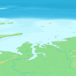
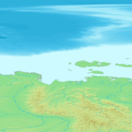
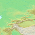
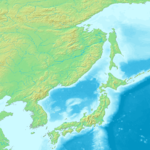
Global 1-kilometer map
This map is derived from GTOPO30GTOPO30
GTOPO30 is a digital elevation model for the world, developed by USGS. It has a 30-arc second resolution , and is split into 33 tiles stored in the USGS DEM file format.-See also:* Shuttle Radar Topography Mission...
data that describes the elevation of Earth's terrain at intervals of 30 arcseconds (approximately 1 km). It uses color and shading instead of contour lines to indicate elevation.
 |
 |
 |
 |
 |
 |
 |
 |
 |
 |
 |
 |
 |
 |
 |
 |
 |
 |
 |
 |
 |
 |
 |
 |
 |
 |
 |
 |
 |
 |
 |
 |
 |
 |
 |
 |
 |
 |
 |
 |
 |
 |
 |
 |
 |
 |
 |
 |
 |
 |
 |
 |
 |
 |
 |
 |
 |
 |
 |
 |
 |
 |
 |
 |
 |
 |
 |
 |
 |
 |
 |
 |
| Each tile is available at a resolution of 1800 × 1800 pixels (approximate file size 1 MB, 60 pixels = 1 degree, 1 pixel = 1 minute) | |||||||||||
Hypsography
Hypsography is the study of the distribution of elevations on the surface of the EarthEarth
Earth is the third planet from the Sun, and the densest and fifth-largest of the eight planets in the Solar System. It is also the largest of the Solar System's four terrestrial planets...
, although the term is sometimes also applied to other rocky planets such as Mars
Mars
Mars is the fourth planet from the Sun in the Solar System. The planet is named after the Roman god of war, Mars. It is often described as the "Red Planet", as the iron oxide prevalent on its surface gives it a reddish appearance...
or Venus
Venus
Venus is the second planet from the Sun, orbiting it every 224.7 Earth days. The planet is named after Venus, the Roman goddess of love and beauty. After the Moon, it is the brightest natural object in the night sky, reaching an apparent magnitude of −4.6, bright enough to cast shadows...
. The term originates from the Greek
Greek language
Greek is an independent branch of the Indo-European family of languages. Native to the southern Balkans, it has the longest documented history of any Indo-European language, spanning 34 centuries of written records. Its writing system has been the Greek alphabet for the majority of its history;...
word "hypsos" meaning height. Most often it is used only in reference to elevation of land but a complete description of Earth's solid surface requires a description of the seafloor as well. Related to the term hypsometry
Hypsometry
Hypsometry is the measurement of land elevation relative to sea level. Bathymetry is the underwater equivalent...
, the measurement of these elevations of a planet's solid surface are taken relative to mean
Arithmetic mean
In mathematics and statistics, the arithmetic mean, often referred to as simply the mean or average when the context is clear, is a method to derive the central tendency of a sample space...
datum, except for Earth which is taken relative to the sea level
Sea level
Mean sea level is a measure of the average height of the ocean's surface ; used as a standard in reckoning land elevation...
.
Temperature
TemperatureTemperature
Temperature is a physical property of matter that quantitatively expresses the common notions of hot and cold. Objects of low temperature are cold, while various degrees of higher temperatures are referred to as warm or hot...
is less in areas of higher elevation. Approximately 6.5 degrees Celsius cooler per 1000 meters. That is due to less density of air at higher altitudes.
See also
- AltitudeAltitudeAltitude or height is defined based on the context in which it is used . As a general definition, altitude is a distance measurement, usually in the vertical or "up" direction, between a reference datum and a point or object. The reference datum also often varies according to the context...
- GeodesyGeodesyGeodesy , also named geodetics, a branch of earth sciences, is the scientific discipline that deals with the measurement and representation of the Earth, including its gravitational field, in a three-dimensional time-varying space. Geodesists also study geodynamical phenomena such as crustal...
- GeodesyGeodesyGeodesy , also named geodetics, a branch of earth sciences, is the scientific discipline that deals with the measurement and representation of the Earth, including its gravitational field, in a three-dimensional time-varying space. Geodesists also study geodynamical phenomena such as crustal...
of North AmericaNorth AmericaNorth America is a continent wholly within the Northern Hemisphere and almost wholly within the Western Hemisphere. It is also considered a northern subcontinent of the Americas...
- Sea Level Datum of 1929Sea Level Datum of 1929The Sea Level Datum of 1929 was the vertical control datum established for vertical control surveying in the United States of America by the General Adjustment of 1929. The datum was used to measure elevation above, and depression below, mean sea level .Mean sea level was measured at 26 tide...
later National Geodetic Vertical Datum of 1929 (NGVD 29) - North American Vertical Datum of 1988North American Vertical Datum of 1988The North American Vertical Datum of 1988 is the vertical control datum of orthometric height established for vertical control surveying in the United States of America based upon the General Adjustment of the North American Datum of 1988....
(NAVD 88)
- Sea Level Datum of 1929
- Geodesy
- List of European cities by elevation
- List of highest mountains
- List of highest towns by country
- Normaal Amsterdams PeilNormaal Amsterdams PeilNormaal Amsterdams Peil or Amsterdam Ordnance Datum is a vertical datum in use in large parts of Western Europe. Originally created for use in the Netherlands, it was adopted by Prussia in 1879 under the name Normalnull, and in 1955 by other European countries.Mayor Johannes Hudde of Amsterdam in...
- NormalhöhennullNormalhöhennullNormalhöhennull or NHN is a standard reference level, the equivalent of sea level, used in Germany to measure height....
- Physical geographyPhysical geographyPhysical geography is one of the two major subfields of geography. Physical geography is that branch of natural science which deals with the study of processes and patterns in the natural environment like the atmosphere, biosphere and geosphere, as opposed to the cultural or built environment, the...
- Summit (topography)Summit (topography)In topography, a summit is a point on a surface that is higher in elevation than all points immediately adjacent to it. Mathematically, a summit is a local maximum in elevation...
- Table of the highest major summits of North AmericaTable of the highest major summits of North AmericaThe following sortable table lists the 200 highest mountain peaks of greater North America with at least 500 meters of topographic prominence....
- Topographic isolationTopographic isolationThe topographic isolation of a summit is the minimum horizontal distance to the nearest point of higher elevation. Topographic isolation represents a radius of dominance in which the summit is the highest point. Topographic isolation can be calculated for small hills and islands as well as for...
- Topographic mapTopographic mapA topographic map is a type of map characterized by large-scale detail and quantitative representation of relief, usually using contour lines in modern mapping, but historically using a variety of methods. Traditional definitions require a topographic map to show both natural and man-made features...
- Topographic prominenceTopographic prominenceIn topography, prominence, also known as autonomous height, relative height, shoulder drop , or prime factor , categorizes the height of the mountain's or hill's summit by the elevation between it and the lowest contour line encircling it and no higher summit...
- TopographyTopographyTopography is the study of Earth's surface shape and features or those ofplanets, moons, and asteroids...
- Vertical pressure variationVertical pressure variationVertical pressure variation is the variation in pressure as a function of elevation. Depending on the fluid in question and the context being referred to, it may also vary significantly in dimensions perpendicular to elevation as well, and these variations have relevance in the context of pressure...