

Sahel
Encyclopedia
The Sahel is the ecoclimatic and biogeographic zone of transition between the Sahara
desert in the North and the Sudanian Savanna
s in the south.
It stretches across the North African continent between the Atlantic Ocean
and the Red Sea
.
The Arabic word sāḥil literally means "shore, coast", describing the appearance of the vegetation of the Sahel as a coastline delimiting the sand of the Sahara
.
The Sahel covers parts of the territory of (from west to east) Senegal
, southern Mauritania
, Mali
, Burkina Faso
, southern Algeria
, Niger
, northern Nigeria
, Chad
, Sudan
(including Darfur
and the southern part of Sudan
), northern Ethiopia
and Eritrea
.
 The Sahel is 5400 km (3,355.4 mi) from the Atlantic Ocean in the west to the Red Sea in the east, in a belt that varies from several hundred to a thousand kilometers (620 miles) in width, covering an area of 3053200 square kilometres (1,178,847.1 sq mi). It is a transitional ecoregion
of semi-arid grasslands, savanna
s, steppes, and thorn shrublands lying between the wooded Sudanian savanna
to the south and the Sahara
to the north.
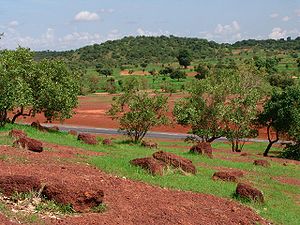
The topography of the Sahel is mainly flat, and the region mostly lies between 200 and 400 meters elevation. Several isolated plateaus and mountain ranges rise from the Sahel, but are designated as separate ecoregions because their flora and fauna are distinct from the surrounding lowlands. Annual rainfall varies from around 200 mm in the north of the Sahel to around 600 mm in the south.
Over the history of Africa the region has been home to some of the most advanced kingdoms benefiting from trade across the desert. Collectively these states are known as the Sahelian kingdoms.
, Schoenefeldia gracilis, and Aristida stipoides. Species of Acacia
are the dominant trees, with Acacia tortilis
the most common, along with Acacia senegal
and Acacia laeta
. Other tree species include Commiphora africana, Balanites aegyptiaca
, Faidherbia albida
, and Boscia senegalensis
. In the northern part of the Sahel, areas of desert shrub, including Panicum turgidum
and Aristida sieberana, alternate with areas of grassland and savanna. During the long dry season, many trees lose their leaves, and the predominantly annual grasses die.
The Sahel was formerly home to large populations of grazing mammals, including the Scimitar-horned Oryx
(Oryx dammah), Dama Gazelle
(Gazella dama), Dorcas Gazelle
(Gazella dorcas) and Red-fronted Gazelle
(Gazella rufifrons), and Bubal Hartebeest
(Alcelaphus busephalus buselaphus), along with large predators like the African Wild Dog
(Lycaon pictus), Cheetah
(Acinonyx jubatus), and Lion
(Panthera leo). The larger species have been greatly reduced in number by over-hunting and competition with livestock, and several species are vulnerable
(Dorcas Gazelle and Red-fronted Gazelle), endangered
(Dama Gazelle, African Wild Dog, cheetah, lion), or extinct
(the Scimitar-horned Oryx is probably extinct in the wild
, and the Bubal Hartebeest
is extinct).
The seasonal wetlands of the Sahel are important for migratory birds moving within Africa and on the African-Eurasian flyways.
s, farming and raising livestock in a system of transhumance
, which is probably the most sustainable way of utilizing the Sahel. The difference between the dry north with higher levels of soil-nutrients and the wetter south is utilized so that the herds graze on high quality feed in the North during the wet season, and trek several hundred kilometers down to the south, to graze on more abundant, but less nutritious feed during the dry period. Increased permanent settlement and pastoralism in fertile areas has been the source of conflicts with traditional nomadic herders.
and African rice began to be cultivated . Around this time, and in the same region, the small Guineafowl
were domesticated.
Around 4000 BC the climate of the Sahara and the Sahel started to become drier at an exceedingly fast pace. This climate change caused lakes and rivers to shrink rather significantly and caused increasing desertification
. This, in turn, decreased the amount of land conducive to settlements and helped to cause migrations of farming communities to the more humid climate of West Africa
.
Their wealth of the states came from controlling the Trans-Saharan trade
routes across the desert, especially the slave trade with the Islamic world
.
Their power came from having large pack animals like camels and horses that were fast enough to keep a large empire under central control and were also useful in battle. All of these empires were also quite decentralized with member cities having a great deal of autonomy. The first large Sahelian kingdoms emerged after 750, and supported several large trading cities in the Niger Bend
region, including Timbuktu
, Gao
, and Djenné
.
The Sahel states were limited from expanding south into the forest zone of the Ashanti and Yoruba
as mounted warriors were all but useless in the forests and the horses and camels could not survive the heat and diseases of the region.
in the late 19th century, as part of French West Africa
. Chad
was added in 1900 as part of French Equatorial Africa
.
The French territories were decolonialized
in 1960.
The eastern Sahel (the part in what is now Sudan) did not fall to the European powers but was annexed by Muhammad Ali of Egypt
in 1820. It came under British administration as part of the Sultanate of Egypt
in 1914.
The Sudanese Sahel became part of independent Sudan
in 1956 and entered a lasting period of political instability and warfare, still ongoing in the War in Darfur
.
The extreme east of the Sahel came under Italian control
as Italian Eritrea
in 1890.
Eritrea was annexed by Haile Selassie of Ethiopia
in 1962, and became independent in 1993 after a long War of Independence
.
. To the development.
In June to August, 2010, famine struck the Sahel. Niger's crops failed to mature in the heat, and famine
occurred. 350,000 faced starvation, and 1,200,000 were at risk of famine. In Chad, the temperature reached 47.6 °C (117.7 °F) on June 22 in Faya-Largeau
, breaking a record set in 1961 at the same location. Niger tied its highest temperature record set in 1998, on also June 22, at 47.1°C in Bilma
. That record was broken the next day, on June 23 when Bilma hit 48.2 °C (118.8 °F). The hottest temperature recorded in Sudan was reached on June 25, at 49.6 °C (121.3 °F) in Dongola
, breaking a record set in 1987. Niger reported on July 14 that diarrhea
, starvation, gastroenteritis
, malnutrition
, and respiratory diseases had sickened or killed many children. The new military junta
appealed for international food aid and took serious steps to call overseas help. On July 26, the heat reached near-record levels over Chad
and Niger
, and about 20 had reportedly died in northern Niger of dehydration by July 27.
of the region.
Major dust storms are a frequent occurrence, as well. During November 2004, a number of major dust storm
s hit the Chad, Nigeria, and northern Cameroon, originating in the Bodélé Depression
. This is a common area for dust storms (occurring, on average, 100 days every year).
On 25 August 2008, heavy dust storms passed over the eastern plains of Somalia
and the northeast of a still drought-hit Kenya
. On March 23, 2010, a major sandstorm hit Mauritania, Senegal, the Gambia, Guinea Bissau, Guinea
, and inland Sierra Leone
. Another struck in southern Algeria
, inland Mauritania, Mali, and northern Côte d’Ivoire at the same time.
Sahara
The Sahara is the world's second largest desert, after Antarctica. At over , it covers most of Northern Africa, making it almost as large as Europe or the United States. The Sahara stretches from the Red Sea, including parts of the Mediterranean coasts, to the outskirts of the Atlantic Ocean...
desert in the North and the Sudanian Savanna
Sudanian Savanna
The Sudanian Savanna is a broad belt of tropical savanna that runs east and west across the African continent, from the Atlantic Ocean in the west to the Ethiopian Highlands in the east. The Sahel, a belt of drier grasslands and acacia savannas, lies to the north, between the Sudanian Savanna and...
s in the south.
It stretches across the North African continent between the Atlantic Ocean
Atlantic Ocean
The Atlantic Ocean is the second-largest of the world's oceanic divisions. With a total area of about , it covers approximately 20% of the Earth's surface and about 26% of its water surface area...
and the Red Sea
Red Sea
The Red Sea is a seawater inlet of the Indian Ocean, lying between Africa and Asia. The connection to the ocean is in the south through the Bab el Mandeb strait and the Gulf of Aden. In the north, there is the Sinai Peninsula, the Gulf of Aqaba, and the Gulf of Suez...
.
The Arabic word sāḥil literally means "shore, coast", describing the appearance of the vegetation of the Sahel as a coastline delimiting the sand of the Sahara
Sahara
The Sahara is the world's second largest desert, after Antarctica. At over , it covers most of Northern Africa, making it almost as large as Europe or the United States. The Sahara stretches from the Red Sea, including parts of the Mediterranean coasts, to the outskirts of the Atlantic Ocean...
.
The Sahel covers parts of the territory of (from west to east) Senegal
Senegal
Senegal , officially the Republic of Senegal , is a country in western Africa. It owes its name to the Sénégal River that borders it to the east and north...
, southern Mauritania
Mauritania
Mauritania is a country in the Maghreb and West Africa. It is bordered by the Atlantic Ocean in the west, by Western Sahara in the north, by Algeria in the northeast, by Mali in the east and southeast, and by Senegal in the southwest...
, Mali
Mali
Mali , officially the Republic of Mali , is a landlocked country in Western Africa. Mali borders Algeria on the north, Niger on the east, Burkina Faso and the Côte d'Ivoire on the south, Guinea on the south-west, and Senegal and Mauritania on the west. Its size is just over 1,240,000 km² with...
, Burkina Faso
Burkina Faso
Burkina Faso – also known by its short-form name Burkina – is a landlocked country in west Africa. It is surrounded by six countries: Mali to the north, Niger to the east, Benin to the southeast, Togo and Ghana to the south, and Côte d'Ivoire to the southwest.Its size is with an estimated...
, southern Algeria
Algeria
Algeria , officially the People's Democratic Republic of Algeria , also formally referred to as the Democratic and Popular Republic of Algeria, is a country in the Maghreb region of Northwest Africa with Algiers as its capital.In terms of land area, it is the largest country in Africa and the Arab...
, Niger
Niger
Niger , officially named the Republic of Niger, is a landlocked country in Western Africa, named after the Niger River. It borders Nigeria and Benin to the south, Burkina Faso and Mali to the west, Algeria and Libya to the north and Chad to the east...
, northern Nigeria
Nigeria
Nigeria , officially the Federal Republic of Nigeria, is a federal constitutional republic comprising 36 states and its Federal Capital Territory, Abuja. The country is located in West Africa and shares land borders with the Republic of Benin in the west, Chad and Cameroon in the east, and Niger in...
, Chad
Chad
Chad , officially known as the Republic of Chad, is a landlocked country in Central Africa. It is bordered by Libya to the north, Sudan to the east, the Central African Republic to the south, Cameroon and Nigeria to the southwest, and Niger to the west...
, Sudan
Sudan
Sudan , officially the Republic of the Sudan , is a country in North Africa, sometimes considered part of the Middle East politically. It is bordered by Egypt to the north, the Red Sea to the northeast, Eritrea and Ethiopia to the east, South Sudan to the south, the Central African Republic to the...
(including Darfur
Darfur
Darfur is a region in western Sudan. An independent sultanate for several hundred years, it was incorporated into Sudan by Anglo-Egyptian forces in 1916. The region is divided into three federal states: West Darfur, South Darfur, and North Darfur...
and the southern part of Sudan
Sudan
Sudan , officially the Republic of the Sudan , is a country in North Africa, sometimes considered part of the Middle East politically. It is bordered by Egypt to the north, the Red Sea to the northeast, Eritrea and Ethiopia to the east, South Sudan to the south, the Central African Republic to the...
), northern Ethiopia
Ethiopia
Ethiopia , officially known as the Federal Democratic Republic of Ethiopia, is a country located in the Horn of Africa. It is the second-most populous nation in Africa, with over 82 million inhabitants, and the tenth-largest by area, occupying 1,100,000 km2...
and Eritrea
Eritrea
Eritrea , officially the State of Eritrea, is a country in the Horn of Africa. Eritrea derives it's name from the Greek word Erethria, meaning 'red land'. The capital is Asmara. It is bordered by Sudan in the west, Ethiopia in the south, and Djibouti in the southeast...
.
Geography
Ecoregion
An ecoregion , sometimes called a bioregion, is an ecologically and geographically defined area that is smaller than an ecozone and larger than an ecosystem. Ecoregions cover relatively large areas of land or water, and contain characteristic, geographically distinct assemblages of natural...
of semi-arid grasslands, savanna
Savanna
A savanna, or savannah, is a grassland ecosystem characterized by the trees being sufficiently small or widely spaced so that the canopy does not close. The open canopy allows sufficient light to reach the ground to support an unbroken herbaceous layer consisting primarily of C4 grasses.Some...
s, steppes, and thorn shrublands lying between the wooded Sudanian savanna
Sudanian Savanna
The Sudanian Savanna is a broad belt of tropical savanna that runs east and west across the African continent, from the Atlantic Ocean in the west to the Ethiopian Highlands in the east. The Sahel, a belt of drier grasslands and acacia savannas, lies to the north, between the Sudanian Savanna and...
to the south and the Sahara
Sahara
The Sahara is the world's second largest desert, after Antarctica. At over , it covers most of Northern Africa, making it almost as large as Europe or the United States. The Sahara stretches from the Red Sea, including parts of the Mediterranean coasts, to the outskirts of the Atlantic Ocean...
to the north.
The topography of the Sahel is mainly flat, and the region mostly lies between 200 and 400 meters elevation. Several isolated plateaus and mountain ranges rise from the Sahel, but are designated as separate ecoregions because their flora and fauna are distinct from the surrounding lowlands. Annual rainfall varies from around 200 mm in the north of the Sahel to around 600 mm in the south.
Over the history of Africa the region has been home to some of the most advanced kingdoms benefiting from trade across the desert. Collectively these states are known as the Sahelian kingdoms.
Flora and fauna
The Sahel is mostly covered in grassland and savanna, with areas of woodland and shrubland. Grass cover is fairly continuous across the region, dominated by annual grass species such as Cenchrus biflorusCenchrus biflorus
Cenchrus biflorus is a species of annual grass in the Poaceae family. Common names include Indian sandbur, Bhurat or Bhurut in India, Haskaneet in Sudan, K 'arangiya in the Hausa language of Nigeria, and Ngibbi in the Kanuri language of Nigeria...
, Schoenefeldia gracilis, and Aristida stipoides. Species of Acacia
Acacia
Acacia is a genus of shrubs and trees belonging to the subfamily Mimosoideae of the family Fabaceae, first described in Africa by the Swedish botanist Carl Linnaeus in 1773. Many non-Australian species tend to be thorny, whereas the majority of Australian acacias are not...
are the dominant trees, with Acacia tortilis
Acacia tortilis
Acacia tortilis, the Umbrella Thorn Acacia, also known as Umbrella Thorn and Israeli Babool, is a medium to large canopied tree native primarily to the savanna and Sahel of Africa , but also occurring in the Middle East....
the most common, along with Acacia senegal
Acacia senegal
is a small deciduous Acacia tree known by the common names Rfaudraksha, Gum Acacia, Gum Arabic Tree, or Gum Senegal Tree. It is native to semi-desert regions of Sub-Saharan Africa, as well as Oman, Pakistan, and northwestern India. It grows to a height of 5-12m, with a trunk up to 30 cm in...
and Acacia laeta
Acacia laeta
Acacia laeta, commonly known as the Gay Acacia, is in the Acacia family.-Description:It is a perennial shrub or tree growing to a height of 4-10m...
. Other tree species include Commiphora africana, Balanites aegyptiaca
Balanites aegyptiaca
Balanites aegyptiaca is a species of tree, classified either as a member of the Zygophyllaceae or the Balanitaceae. This tree is native to much of Africa and parts of the Middle East....
, Faidherbia albida
Faidherbia albida
Faidherbia albida is a species of Faidherbia native to Africa and the Middle East, formerly widely included in the genus Acacia. It has also been introduced to India and Pakistan. Common names for it include Apple-ring Acacia, Ana Tree and Winter Thorn.It is a thorny tree growing up to 6–30 m tall...
, and Boscia senegalensis
Boscia senegalensis
Boscia senegalensis or Aizen, is a member of the family Capparaceae. The plant originated from West Africa. Still a traditional food plant in Africa, this little-known fruit has potential to improve nutrition, boost food security, foster rural development and support sustainable landcare.-External...
. In the northern part of the Sahel, areas of desert shrub, including Panicum turgidum
Panicum turgidum
Panicum turgidum is an old world clumping desert bunchgrass of the Panicum genus.-Distribution:It is common across the Sahara and Arabia, from Senegal to Pakistan, and known by the a number of common names, most widely as Taman, tuman, or thaman in Egypt and Arabia; merkba or markouba in...
and Aristida sieberana, alternate with areas of grassland and savanna. During the long dry season, many trees lose their leaves, and the predominantly annual grasses die.
The Sahel was formerly home to large populations of grazing mammals, including the Scimitar-horned Oryx
Scimitar Oryx
The Scimitar Oryx, or Scimitar-Horned Oryx, is a species of oryx which formerly inhabited the whole of North Africa. It has been classified as extinct in the wild by the IUCN.-Etymology and taxonomy:...
(Oryx dammah), Dama Gazelle
Dama Gazelle
The Dama Gazelle is a species of gazelle. It lives in Africa in the Sahara desert and migrates south in search of food during the dry season. Their habitat includes open steppes, bushy, grassy steppes, semi-desert, and deserts, while their diet includes grasses, leaves, shoots, fruit, and...
(Gazella dama), Dorcas Gazelle
Dorcas Gazelle
The Dorcas Gazelle , also known as the Ariel Gazelle, is a small and common gazelle. The Dorcas Gazelle stands approximately 55-65 cm . Dorcas gazelle have a head and body length of 90-110 cm and a weight of 15-20 kg...
(Gazella dorcas) and Red-fronted Gazelle
Red-fronted Gazelle
The Red-fronted gazelle is a species of gazelle that is widely but unevenly distributed across the middle Africa from Senegal to north-eastern Ethiopia. It is mainly resident in the Sahel zone, a narrow cross-Africa band south of the Sahara, where it prefers arid grasslands, wooded savannas and...
(Gazella rufifrons), and Bubal Hartebeest
Bubal Hartebeest
The Bubal Hartebeest is classified as an extinct antelope.The statement that the antelope was extinct in 1923 has been refuted by the following source written in 1945...
(Alcelaphus busephalus buselaphus), along with large predators like the African Wild Dog
African Wild Dog
Lycaon pictus is a large canid found only in Africa, especially in savannas and lightly wooded areas. It is variously called the African wild dog, African hunting dog, Cape hunting dog, painted dog, painted wolf, painted hunting dog, spotted dog, or ornate wolf...
(Lycaon pictus), Cheetah
Cheetah
The cheetah is a large-sized feline inhabiting most of Africa and parts of the Middle East. The cheetah is the only extant member of the genus Acinonyx, most notable for modifications in the species' paws...
(Acinonyx jubatus), and Lion
Lion
The lion is one of the four big cats in the genus Panthera, and a member of the family Felidae. With some males exceeding 250 kg in weight, it is the second-largest living cat after the tiger...
(Panthera leo). The larger species have been greatly reduced in number by over-hunting and competition with livestock, and several species are vulnerable
Vulnerable species
On 30 January 2010, the IUCN Red List of Threatened Species identified 9694 Vulnerable species, subspecies and varieties, stocks and sub-populations.-References:...
(Dorcas Gazelle and Red-fronted Gazelle), endangered
Endangered species
An endangered species is a population of organisms which is at risk of becoming extinct because it is either few in numbers, or threatened by changing environmental or predation parameters...
(Dama Gazelle, African Wild Dog, cheetah, lion), or extinct
Extinction
In biology and ecology, extinction is the end of an organism or of a group of organisms , normally a species. The moment of extinction is generally considered to be the death of the last individual of the species, although the capacity to breed and recover may have been lost before this point...
(the Scimitar-horned Oryx is probably extinct in the wild
Extinct in the Wild
Extinct in the Wild is a conservation status assigned to species or lower taxa, the only known living members of which are being kept in captivity or as a naturalized population outside its historic range.-Examples:...
, and the Bubal Hartebeest
Bubal Hartebeest
The Bubal Hartebeest is classified as an extinct antelope.The statement that the antelope was extinct in 1923 has been refuted by the following source written in 1945...
is extinct).
The seasonal wetlands of the Sahel are important for migratory birds moving within Africa and on the African-Eurasian flyways.
Transhumance
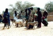
Traditionally, most of the people in the Sahel have been semi-nomadNomad
Nomadic people , commonly known as itinerants in modern-day contexts, are communities of people who move from one place to another, rather than settling permanently in one location. There are an estimated 30-40 million nomads in the world. Many cultures have traditionally been nomadic, but...
s, farming and raising livestock in a system of transhumance
Transhumance
Transhumance is the seasonal movement of people with their livestock between fixed summer and winter pastures. In montane regions it implies movement between higher pastures in summer and to lower valleys in winter. Herders have a permanent home, typically in valleys. Only the herds travel, with...
, which is probably the most sustainable way of utilizing the Sahel. The difference between the dry north with higher levels of soil-nutrients and the wetter south is utilized so that the herds graze on high quality feed in the North during the wet season, and trek several hundred kilometers down to the south, to graze on more abundant, but less nutritious feed during the dry period. Increased permanent settlement and pastoralism in fertile areas has been the source of conflicts with traditional nomadic herders.
Early agriculture
The first instances of domestication of plants for agricultural purposes in Africa occurred in the Sahel region circa 5000 BC, when sorghumSorghum
Sorghum is a genus of numerous species of grasses, one of which is raised for grain and many of which are used as fodder plants either cultivated or as part of pasture. The plants are cultivated in warmer climates worldwide. Species are native to tropical and subtropical regions of all continents...
and African rice began to be cultivated . Around this time, and in the same region, the small Guineafowl
Guineafowl
The guineafowl are a family of birds in the Galliformes order, although some authorities include the guineafowl as a subfamily, Numidinae, of the family Phasianidae...
were domesticated.
Around 4000 BC the climate of the Sahara and the Sahel started to become drier at an exceedingly fast pace. This climate change caused lakes and rivers to shrink rather significantly and caused increasing desertification
Desertification
Desertification is the degradation of land in drylands. Caused by a variety of factors, such as climate change and human activities, desertification is one of the most significant global environmental problems.-Definitions:...
. This, in turn, decreased the amount of land conducive to settlements and helped to cause migrations of farming communities to the more humid climate of West Africa
West Africa
West Africa or Western Africa is the westernmost region of the African continent. Geopolitically, the UN definition of Western Africa includes the following 16 countries and an area of approximately 5 million square km:-Flags of West Africa:...
.
Sahelian kingdoms
The Sahelian kingdoms were a series of monarchies centered in the Sahel, between the 9th and 18th centuriesTheir wealth of the states came from controlling the Trans-Saharan trade
Trans-Saharan trade
Trans-Saharan trade requires travel across the Sahara to reach sub-Saharan Africa. While existing from prehistoric times, the peak of trade extended from the 8th century until the late 16th century.- Increasing desertification and economic incentive :...
routes across the desert, especially the slave trade with the Islamic world
Arab slave trade
The Arab slave trade was the practice of slavery in the Arab World, mainly Western Asia, North Africa, East Africa and certain parts of Europe during their period of domination by Arab leaders. The trade was focused on the slave markets of the Middle East and North Africa...
.
Their power came from having large pack animals like camels and horses that were fast enough to keep a large empire under central control and were also useful in battle. All of these empires were also quite decentralized with member cities having a great deal of autonomy. The first large Sahelian kingdoms emerged after 750, and supported several large trading cities in the Niger Bend
Niger River
The Niger River is the principal river of western Africa, extending about . Its drainage basin is in area. Its source is in the Guinea Highlands in southeastern Guinea...
region, including Timbuktu
Timbuktu
Timbuktu , formerly also spelled Timbuctoo, is a town in the West African nation of Mali situated north of the River Niger on the southern edge of the Sahara Desert. The town is the capital of the Timbuktu Region, one of the eight administrative regions of Mali...
, Gao
Gao
Gao is a town in eastern Mali on the River Niger lying ESE of Timbuktu. Situated on the left bank of the river at the junction with the Tilemsi valley, it is the capital of the Gao Region and had a population of 86,663 in 2009....
, and Djenné
Djenné
Djenné is an Urban Commune and town in the Inland Niger Delta region of central Mali. In the 2009 census the commune had a population of 32,944. Administratively it is part of the Mopti Region....
.
The Sahel states were limited from expanding south into the forest zone of the Ashanti and Yoruba
Yoruba people
The Yoruba people are one of the largest ethnic groups in West Africa. The majority of the Yoruba speak the Yoruba language...
as mounted warriors were all but useless in the forests and the horses and camels could not survive the heat and diseases of the region.
Colonial period
The western Sudan fell to FranceFrench Third Republic
The French Third Republic was the republican government of France from 1870, when the Second French Empire collapsed due to the French defeat in the Franco-Prussian War, to 1940, when France was overrun by Nazi Germany during World War II, resulting in the German and Italian occupations of France...
in the late 19th century, as part of French West Africa
French West Africa
French West Africa was a federation of eight French colonial territories in Africa: Mauritania, Senegal, French Sudan , French Guinea , Côte d'Ivoire , Upper Volta , Dahomey and Niger...
. Chad
Chad
Chad , officially known as the Republic of Chad, is a landlocked country in Central Africa. It is bordered by Libya to the north, Sudan to the east, the Central African Republic to the south, Cameroon and Nigeria to the southwest, and Niger to the west...
was added in 1900 as part of French Equatorial Africa
French Equatorial Africa
French Equatorial Africa or the AEF was the federation of French colonial possessions in Middle Africa, extending northwards from the Congo River to the Sahara Desert.-History:...
.
The French territories were decolonialized
Decolonization of Africa
The decolonization of Africa followed World War II as colonized peoples agitated for independence and colonial powers withdrew their administrators from Africa.-Background:...
in 1960.
The eastern Sahel (the part in what is now Sudan) did not fall to the European powers but was annexed by Muhammad Ali of Egypt
Muhammad Ali of Egypt
Muhammad Ali Pasha al-Mas'ud ibn Agha was a commander in the Ottoman army, who became Wāli, and self-declared Khedive of Egypt and Sudan...
in 1820. It came under British administration as part of the Sultanate of Egypt
Sultanate of Egypt
The Sultanate of Egypt is the name of the short-lived protectorate that the United Kingdom imposed over Egypt between 1914 and 1922.-History:...
in 1914.
The Sudanese Sahel became part of independent Sudan
Sudan
Sudan , officially the Republic of the Sudan , is a country in North Africa, sometimes considered part of the Middle East politically. It is bordered by Egypt to the north, the Red Sea to the northeast, Eritrea and Ethiopia to the east, South Sudan to the south, the Central African Republic to the...
in 1956 and entered a lasting period of political instability and warfare, still ongoing in the War in Darfur
War in Darfur
The Darfur Conflict was a guerrilla conflict or civil war centered on the Darfur region of Sudan. It began in February 2003 when the Sudan Liberation Movement/Army and Justice and Equality Movement groups in Darfur took up arms, accusing the Sudanese government of oppressing non-Arab Sudanese in...
.
The extreme east of the Sahel came under Italian control
Italian Empire
The Italian Empire was created after the Kingdom of Italy joined other European powers in establishing colonies overseas during the "scramble for Africa". Modern Italy as a unified state only existed from 1861. By this time France, Spain, Portugal, Britain, and the Netherlands, had already carved...
as Italian Eritrea
Italian Eritrea
Italian Eritrea was the first colony of the Kingdom of Italy. It was created in 1890 and lasted officially until 1947.-Acquisition of Assab and creation of the colony:...
in 1890.
Eritrea was annexed by Haile Selassie of Ethiopia
Ethiopia
Ethiopia , officially known as the Federal Democratic Republic of Ethiopia, is a country located in the Horn of Africa. It is the second-most populous nation in Africa, with over 82 million inhabitants, and the tenth-largest by area, occupying 1,100,000 km2...
in 1962, and became independent in 1993 after a long War of Independence
Eritrean War of Independence
The Eritrean War of Independence was a conflict fought between the Ethiopian government and Eritrean separatists, both before and during the Ethiopian Civil War. The war started when Eritrea’s autonomy within Ethiopia, where troops were already stationed, was unilaterally revoked...
.
Recent droughts
There was a major drought in the Sahel in 1914, caused by annual rains far below average, that caused a large-scale famine. The 1960s saw a large increase in rainfall in the region, making the northern drier region more accessible. There was a push, supported by governments, for people to move northwards. As the long drought-period from 1968 through 1974 began, the grazing quickly became unsustainable, and large-scale denuding of the terrain followed. Like the drought in 1914, this led to a large-scale famine, but this time it was somewhat tempered by international visibility and an outpouring of aid. This catastrophe led to the founding of the International Fund for Agricultural DevelopmentInternational Fund for Agricultural Development
The International Fund for Agricultural Development , a specialized agency of the United Nations, was established as an international financial institution in 1977 as one of the major outcomes of the 1974 World Food Conference. IFAD is dedicated to eradicating rural poverty in developing countries...
. To the development.
In June to August, 2010, famine struck the Sahel. Niger's crops failed to mature in the heat, and famine
Famine
A famine is a widespread scarcity of food, caused by several factors including crop failure, overpopulation, or government policies. This phenomenon is usually accompanied or followed by regional malnutrition, starvation, epidemic, and increased mortality. Every continent in the world has...
occurred. 350,000 faced starvation, and 1,200,000 were at risk of famine. In Chad, the temperature reached 47.6 °C (117.7 °F) on June 22 in Faya-Largeau
Faya-Largeau
Located in the Sahara, Faya's climate is classed as hot desert on the Köppen climate classification. It experiences hot winters and very hot summers with the peak average maximum temperature reaching in May and the average minimum reaching its lowest in January at . Rainfall averages out at about...
, breaking a record set in 1961 at the same location. Niger tied its highest temperature record set in 1998, on also June 22, at 47.1°C in Bilma
Bilma
Bilma is an oasis town in north east Niger with a population of around 2,500 people. It lies protected from the desert dunes under the Kaouar Cliffs and is the largest town along the Kaouar escarpment...
. That record was broken the next day, on June 23 when Bilma hit 48.2 °C (118.8 °F). The hottest temperature recorded in Sudan was reached on June 25, at 49.6 °C (121.3 °F) in Dongola
Dongola
Dongola , also spelled Dunqulah, and formerly known as Al 'Urdi, is the capital of the state of Northern in Sudan, on the banks of the Nile. It should not be confused with Old Dongola, an ancient city located 80 km upstream on the opposite bank....
, breaking a record set in 1987. Niger reported on July 14 that diarrhea
Diarrhea
Diarrhea , also spelled diarrhoea, is the condition of having three or more loose or liquid bowel movements per day. It is a common cause of death in developing countries and the second most common cause of infant deaths worldwide. The loss of fluids through diarrhea can cause dehydration and...
, starvation, gastroenteritis
Gastroenteritis
Gastroenteritis is marked by severe inflammation of the gastrointestinal tract involving both the stomach and small intestine resulting in acute diarrhea and vomiting. It can be transferred by contact with contaminated food and water...
, malnutrition
Malnutrition
Malnutrition is the condition that results from taking an unbalanced diet in which certain nutrients are lacking, in excess , or in the wrong proportions....
, and respiratory diseases had sickened or killed many children. The new military junta
Military junta
A junta or military junta is a government led by a committee of military leaders. The term derives from the Spanish language junta meaning committee, specifically a board of directors...
appealed for international food aid and took serious steps to call overseas help. On July 26, the heat reached near-record levels over Chad
Chad
Chad , officially known as the Republic of Chad, is a landlocked country in Central Africa. It is bordered by Libya to the north, Sudan to the east, the Central African Republic to the south, Cameroon and Nigeria to the southwest, and Niger to the west...
and Niger
Niger
Niger , officially named the Republic of Niger, is a landlocked country in Western Africa, named after the Niger River. It borders Nigeria and Benin to the south, Burkina Faso and Mali to the west, Algeria and Libya to the north and Chad to the east...
, and about 20 had reportedly died in northern Niger of dehydration by July 27.
Desertification and soil loss
Over-farming, over-grazing, and over-population of marginal lands and natural soil erosion have caused serious desertificationDesertification
Desertification is the degradation of land in drylands. Caused by a variety of factors, such as climate change and human activities, desertification is one of the most significant global environmental problems.-Definitions:...
of the region.
Major dust storms are a frequent occurrence, as well. During November 2004, a number of major dust storm
Dust storm
A dust / sand storm is a meteorological phenomenon common in arid and semi-arid regions. Dust storms arise when a gust front or other strong wind blows loose sand and dirt from a dry surface. Particles are transported by saltation and suspension, causing soil to move from one place and deposition...
s hit the Chad, Nigeria, and northern Cameroon, originating in the Bodélé Depression
Bodélé Depression
The Bodélé Depression , located at the southern edge of the Sahara Desert in north central Africa, is the lowest point in Chad. Dust storms from the Bodélé Depression occur on average about 100 days per year , one typical example being the massive dust storms that swept over West Africa and the...
. This is a common area for dust storms (occurring, on average, 100 days every year).
On 25 August 2008, heavy dust storms passed over the eastern plains of Somalia
Somalia
Somalia , officially the Somali Republic and formerly known as the Somali Democratic Republic under Socialist rule, is a country located in the Horn of Africa. Since the outbreak of the Somali Civil War in 1991 there has been no central government control over most of the country's territory...
and the northeast of a still drought-hit Kenya
Kenya
Kenya , officially known as the Republic of Kenya, is a country in East Africa that lies on the equator, with the Indian Ocean to its south-east...
. On March 23, 2010, a major sandstorm hit Mauritania, Senegal, the Gambia, Guinea Bissau, Guinea
Guinea
Guinea , officially the Republic of Guinea , is a country in West Africa. Formerly known as French Guinea , it is today sometimes called Guinea-Conakry to distinguish it from its neighbour Guinea-Bissau. Guinea is divided into eight administrative regions and subdivided into thirty-three prefectures...
, and inland Sierra Leone
Sierra Leone
Sierra Leone , officially the Republic of Sierra Leone, is a country in West Africa. It is bordered by Guinea to the north and east, Liberia to the southeast, and the Atlantic Ocean to the west and southwest. Sierra Leone covers a total area of and has an estimated population between 5.4 and 6.4...
. Another struck in southern Algeria
Algeria
Algeria , officially the People's Democratic Republic of Algeria , also formally referred to as the Democratic and Popular Republic of Algeria, is a country in the Maghreb region of Northwest Africa with Algiers as its capital.In terms of land area, it is the largest country in Africa and the Arab...
, inland Mauritania, Mali, and northern Côte d’Ivoire at the same time.
See also
- Community of Sahel-Saharan StatesCommunity of Sahel-Saharan StatesCEN-SAD or the Community of Sahel-Saharan States aims to create a free trade area...
- Epidemiology
- Green Sahara
- 2010 Sahel famine2010 Sahel famineA large-scale, drought-induced famine occurred in Africa's Sahel region and many parts of the neighboring Sénégal River Area and Horn of Africa from February to August 2010...
- Sahel droughtSahel drought[[File:Greening Sahel 1982-1999.jpg|thumb|300px|Recent "Greening" of the Sahel: The results of trend analyses of time series over the Sahel region of seasonally integrated NDVI using NOAA AVHRR NDVI-data from 1982 to 1999...
- Sudan (region)Sudan (region)The Sudan is the name given to a geographic region to the south of the Sahara, stretching from Western to Eastern Africa. The name derives from the Arabic bilâd as-sûdân or "land of the Blacks"...
- Sudanian SavannaSudanian SavannaThe Sudanian Savanna is a broad belt of tropical savanna that runs east and west across the African continent, from the Atlantic Ocean in the west to the Ethiopian Highlands in the east. The Sahel, a belt of drier grasslands and acacia savannas, lies to the north, between the Sudanian Savanna and...
- Pan Sahel InitiativePan Sahel InitiativeThe Pan-Sahel Initiative, according to a November 7, 2002, by the Office of Counterterrorism, U.S. Department of State, was "a State-led effort to assist Mali, Niger, Chad, and Mauritania in detecting and responding to suspicious movement of people and goods across and within their borders through...
- Sahara Conservation FundSahara Conservation FundThe Sahara Conservation Fund is an international non-governmental organization established in 2004 to conserve the wildlife of the Sahara and bordering Sahelian grasslands...
- Trans-Sahelian HighwayTrans-Sahelian HighwayThe Trans-Sahelian Highway or Trans-Sahel Highway is a transnational highway project to pave, improve and ease border formalities on a highway route through the southern fringes of the Sahel region in West Africa between Dakar, Senegal in the west and Ndjamena, Chad, in the east...
Further reading
}}.- Moseley, W.G. 2008. “Strengthening Livelihoods in Sahelian West Africa: The Geography of Development and Underdevelopment in a Peripheral Region.” Geographische Rundschau International Edition, 4(4): 44-50. http://works.bepress.com/cgi/viewcontent.cgi?article=1069&context=william_moseley