

2007 Atlantic hurricane season
Encyclopedia
The 2007 Atlantic hurricane season was an active Atlantic hurricane season
that produced 17 tropical cyclone
s, 15 tropical storms, six hurricanes, and two major hurricanes. It officially started on June 1 and ended on November 30, dates which conventionally delimit the period during which most tropical cyclones form in the Atlantic Ocean. The first tropical cyclone, Subtropical Storm Andrea
developed on May 9, while the last storm, Tropical Storm Olga
, dissipated on December 13. The most intense hurricane, Dean
, is tied for the seventh most intense Atlantic hurricane ever recorded as well as the third most intense Atlantic hurricane at landfall. The season was one of only four on record for the Atlantic
with more than one Category 5 storm. It was the second on record in which an Atlantic hurricane, Felix
, and an eastern Pacific hurricane, Henriette
, made landfall on the same day. September had a record-tying eight storms, although the strengths and durations of most of the storms were low. Aside from hurricanes Dean
and Felix
, none of the storms in the season exceeded Category 1 intensity.
Pre-season forecasts by the Colorado State University
(CSU) called for 14 named storms and 7 hurricanes, of which three were expected to attain major hurricane status. The National Oceanic and Atmospheric Administration
(NOAA) later issued its initial forecast, which predicted 13 to 17 named storms, 7 to 10 hurricanes and three to five major hurricanes. After several revisions in the projected number of storms, NOAA and CSU lowered their forecasts by the middle of the season.
Several storms made landfall or directly affected land. Hurricanes Dean and Felix made landfall at Category 5 intensity, causing severe damage in parts of Mexico and Central America, respectively. Both storm names, as well as Noel
, the name of a hurricane that affected the Caribbean
, were retired from the naming list of Atlantic hurricanes. The United States was affected by five cyclones, although the storms were generally weak; three tropical depressions and only one tropical storm, Gabrielle
, and one hurricane, Humberto
, made landfall in the country. Elsewhere, three storms directly affected Canada, although none severely. The combined storms killed at least 423 people and caused about $3 billion (2007 USD, $ USD) in damage.The cumulative damage figures were obtained by summing the damage figures on the individual Tropical Cyclone Reports referenced throughout the article, with the exception of Hurricane Dean
. Dean's damage figures were obtained by adding the per-country totals referenced in the Impact section of this article.
, and their associates at Colorado State University
issue forecasts of hurricane activity
each year, separately from NOAA. Klotzbach's team, formerly led by Gray, determined the average number of storms per season between 1950 and 2000 to be 9.6 tropical storms, 5.9 hurricanes, and 2.3 major hurricanes (storms exceeding Category 3 on the Saffir-Simpson Hurricane Scale
). A normal season, as defined by NOAA, has 9 to 12 named storms, of which five to seven reach hurricane strength and one to three become major hurricanes.
, including the Florida peninsula, and a 40 percent chance of at least one such strike on the Gulf Coast
from the Florida Panhandle
westward. The potential for major hurricane activity in the Caribbean
was forecast to be above average, and the team predicted that El Niño
, associated with reduced hurricane activity in the Atlantic, would dissipate by the active portion of the season.
On April 3 a new forecast was issued, calling for a very active hurricane season of 17 named storms, nine hurricanes and five intense hurricanes. The increase in the forecast was attributed to the rapid dissipation of El Niño conditions. The team also forecast a neutral or weak-to-moderate La Niña
and noted that sea surface temperature
s were much higher than average. The estimated potential for at least one major hurricane to affect the U.S. was increased to 74 percent; the East Coast potential increased to 50 percent, and from the Florida Panhandle westward to Brownsville, Texas
, the probability rose to 49 percent. However, the team's report noted that while they predicted an active season, it was not suggesting that 2007 would be "as active as the 2004 and 2005 seasons".
) issued a forecast of 10 tropical storms in the July to November period with a 70 percent chance that the number would be in the range of 7 to 13. On August 3, 2007, Klotzbach's team lowered its season estimate to 15 named storms, of which eight were to become hurricanes and four to become major hurricanes. Team members noted that conditions had become slightly less favorable for storms than earlier in the year. Sea surface temperature anomalies were cooler, and several Saharan Air Layer
events had suppressed development of tropical cyclones. El Niño-Southern Oscillation
(ENSO) conditions were also noted to have been slightly cooler.
On August 9, 2007, NOAA revised its season estimate slightly downwards to 13 to 16 named storms of which seven to nine were to be hurricanes and three to five major hurricanes. However, the agency reaffirmed its prediction of an above-average season, citing warmer-than-normal sea surface temperature
s in parts of the Atlantic Ocean and Caribbean Sea
and the likelihood of La Niña conditions during the peak of the season.
Overall, the season's activity was reflected with a cumulative accumulated cyclone energy
(ACE) rating of 74. ACE is, broadly speaking, a measure of the power of the hurricane multiplied by the length of time it existed, so storms that last a long time, as well as particularly strong hurricanes, have high ACEs. ACE is only calculated for full advisories on tropical systems at or exceeding 34 knots (39 mph, 63 km/h) or tropical storm strength. Subtropical cyclone
s, such as Andrea or the initial portions of Gabrielle, Jerry, and Olga, are excluded from the total.
.jpg) The first storm of the season, Subtropical Storm Andrea
The first storm of the season, Subtropical Storm Andrea
, formed out of a large extratropical cyclone
off the coast of the United States on May 9, about 150 miles (240 km) northeast of Daytona Beach, Florida
. Andrea was short-lived, dissipating on May 11. It was the first pre-season storm to develop since Tropical Storm Ana
in April 2003 and the first Atlantic named storm in May since Tropical Storm Arlene in 1981. Six people drowned along the Southeast U.S. Coast, but property damage was minimal because the cyclone never made landfall.
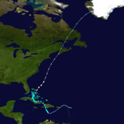
On June 1, Tropical Storm Barry
developed from a trough
of low pressure in the southeastern Gulf of Mexico
. It accelerated to the northeast before reaching a peak intensity of 997 mbar and making landfall on Florida
. Barry dissipated on June 2.
An area of low pressure formed near the Bahamas on July 28 and gradually began to organize while moving north-northeast. On July 30 it was classified as Tropical Depression Three and was named Tropical Storm Chantal
shortly thereafter while south of Nova Scotia
. The storm weakened on August 1 and made landfall on Newfoundland; it later tracked into the North Atlantic as an extratropical storm.
 On August 11, a tropical wave
moved off the west coast of Africa, and, encountering favorable conditions, quickly spawned Tropical Depression Four, roughly 520 miles (835 km) west-southwest of Cape Verde
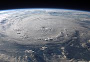
. The depression was upgraded to Tropical Storm Dean
on August 14 and became the first hurricane of the season just two days after. Dean reached a peak intensity as a Category 5 on the Saffir-Simpson Hurricane Scale—the strongest Atlantic hurricane since Hurricane Wilma
—and it was tied for the seventh most intense Atlantic storm of all time. The hurricane made landfall on the Yucatán Peninsula
on August 21, causing severe damage and at least 44 deaths.
Tropical Storm Erin
formed on August 16 in the Gulf of Mexico from a persistent area of convection. Erin moved northwestward, attaining peak winds of 40 mph (64.4 km/h), before making landfall on the Texas
coast. Early on August 19 after entering Oklahoma
, the remnants of Erin suddenly re-intensified to maximum sustained winds of 60 mph (95 km/h) a short distance west of Oklahoma City
. Although it was generally weak, Erin caused heavy flooding and 16 deaths.
An area of disturbed weather east of the Windward Islands
was designated Tropical Depression Six on August 31. Early on September 1, it was named Tropical Storm Felix
, and it was upgraded to a hurricane later that day. Tracking generally westward, it rapidly intensified to Category 5, and after fluctuating in strength, made landfall on Nicaragua
with 160 mph (257.5 km/h) winds. At least 133 deaths and more than $50 million (2007 USD
) in damage have been attributed to Felix. With Felix, the 2007 Atlantic hurricane season became the only one of its kind known to include two hurricanes making landfall at Category 5.
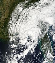
originated from a cold front
that moved off the U.S. East Coast on September 7, initially existing as a subtropical storm. By the next day, however, the system gained tropical characteristics, and Gabrielle reached peak winds of 60 mph (96.6 km/h) just before making landfall on the coast of North Carolina
and turning northeast into the open waters of the Atlantic Ocean.
A large tropical wave
emerged off the coast of Africa on September 6 and moved westward across the Atlantic. Gradually, the associated convection organized, and it was named Tropical Storm Ingrid on September 12. Ingrid remained weak, staying at moderate tropical storm intensity its for its entire life; it never affected land.
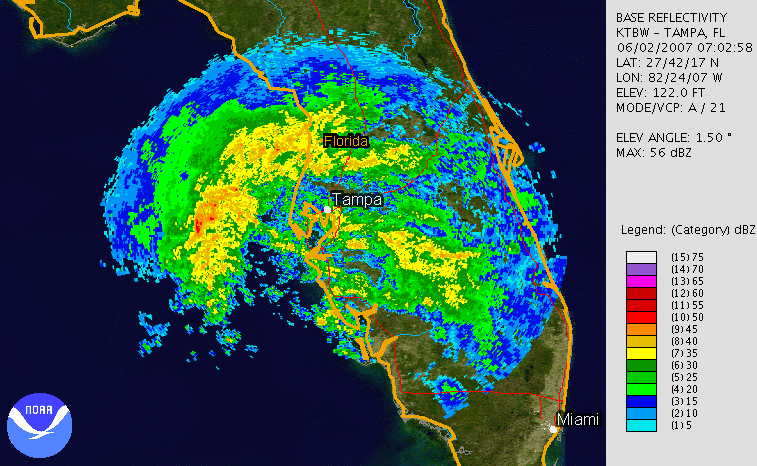
 On September 12, an area of thunderstorm activity in the Gulf of Mexico organized into Tropical Depression Nine, about 60 mi (96.6 km) southeast of Matagorda, Texas
. Within three hours of forming, it was named Tropical Storm Humberto
, and it turned to the north-northeast before rapidly intensifying. A Hurricane Hunters
aircraft found that Humberto had reached hurricane status while just 15 mi (24.1 km) offshore in the early hours of September 13 before making landfall at Category 1 strength.
Tropical Depression Ten
formed from the complex interaction between an upper-level low
, a tropical wave
that produced Tropical Storm Ingrid, and the tail end of a cold front
. Initially classified as a subtropical depression, it attained tropical characteristics shortly before making landfall on the Florida Panhandle
.
On September 22, Subtropical Storm Jerry developed in the northern Atlantic. After about 48 hours it attained tropical characteristics, and it subsequently reached a peak intensity of 1,003 mbar. Jerry soon dissipated without affecting land.
A large tropical wave associated with a large area of low pressure emerged off the coast of Africa on September 21. Tracking westward, it had developed sufficient convection to be designated as a tropical depression on September 24, and was upgraded to Tropical Storm Karen
the next day. Though originally believed to have peaked at tropical storm status, post-season analysis revealed that it briefly attained Category 1 hurricane strength.
A tropical wave emerged off the coast of Africa on September 11 and traversed the Atlantic, crossing the Yucatán Peninsula
on September 21. On September 25 an associated low organized into a tropical depression in the southwest Gulf of Mexico. Further organization took place, and the depression was upgraded to Tropical Storm Lorenzo
. Lorenzo peaked with winds of 80 mph (128.7 km/h)—a minimal hurricane—and made landfall near Tecolutla, Mexico.
Tropical Storm Melissa formed on September 28 from a tropical wave that emerged into the Atlantic two days earlier. Certain factors prevented significant intensification, and Melissa failed to strengthen past a minimal tropical storm. Tracking northwestward, it dissipated on September 30.
 A surface low pressure system formed on the tail end of a large area of disturbed weather that stretched from the Caribbean Sea
into the western Atlantic. While 645 nmi (1,195 km) southeast of Bermuda
the system was sufficiently organized to be declared a tropical depression on October 11. Failing to intensify, it dissipated the next day.
During the evening of October 27 a low pressure system that had been slowly developing over the eastern Caribbean organization into Tropical Depression Sixteen. The next day, it was upgraded to Tropical Storm Noel
and made landfall on Haiti on October 29. Noel meandered across the western Caribbean for the next three days; the storm intensified into a hurricane on November 1. Tracking northward, it began its transition into an extratropical cyclone
on November 2, becoming fully extratropical on November 4 while over Labrador
. As a powerful extratropical cyclone
, it crossed back into the Atlantic and began a track towards western Greenland
.
In the second week of December, after the official end of the hurricane season, a low developed east of the northernmost Lesser Antilles
. On December 10 it was designated as Subtropical Storm Olga
while north of Puerto Rico
. The storm made landfall on December 11 on the eastern tip of the Dominican Republic and attained tropical characteristics while over land. By December 13, Olga had dissipated, having killed an estimated 40 people.
In Hispaniola
, Hurricane Dean
killed 15 people and destroyed hundreds of homes. Dean also left $616 million (2007 USD, $ USD) in damage on Martinique
and $154 million (2007 USD, $ USD) on Guadeloupe
. Hurricane Felix took a similar path, although its effects were not severe; damage on Tobago
was estimated at $250,000 (2007 TTD
; $40,000 2007 USD, $ USD). Hurricane Noel caused severe damage throughout the region. Torrential rainfall and mudslides caused by the storm killed at least 87 people in the Dominican Republic
and at least 73 in Haiti
. In addition, Tropical Storm Olga
triggered flooding in the Dominican Republic, killing at least 37 people.
Hurricane Felix made landfall just south of the border between Nicaragua
and Honduras
, in a region historically known as the Mosquito Coast
, as a Category 5 hurricane with 160 mph (260 km/h) winds on September 4. Residents of the region were reported to have been given little warning of the oncoming hurricane, which left many fisherman stranded at sea. In all, Felix killed at least 130 people, and damage in Nicaragua totaled C$869.3 million (2007 NIO
; $46.7 million 2007 USD, $ USD). In Mexico, Hurricane Dean made landfall on the Yucatán Peninsula
on August 21 as a Category 5 hurricane. Throughout its track, Dean killed 44 people Of Author’s Seasonal And Monthly Forecasts|year=2007|publisher=Colorado State University|accessdate=2008-06-05|url=http://hurricane.atmos.colostate.edu/Forecasts/2007/nov2007/nov2007.pdf|format=PDF}} and caused several billion dollars in damage. Hurricane Lorenzo
struck central Mexico to the south-southwest of Tuxpan as a Category 1 hurricane, causing an estimated $1 billion (2007 MXN; $92 million 2007 USD, $ USD) in damage. Lorenzo caused six deaths in Tuxpan and destroyed 169 houses in Puebla
.
 During the season, five Atlantic storms affected the United States. However, these storms were relatively weak; three tropical depressions and one tropical storm and hurricane made landfall in the country, with their names being Gabrielle
and Humberto
. Subtropical Storm Andrea
meandered off the Southeastern coast, producing 34 ft (10.4 m) waves on the coast of South Carolina
. Almost a month later, Tropical Storm Barry
struck the state of Florida. The rainfall resulted in slick roads, which caused two traffic-related deaths, and a woman was killed after being injured by rough surf. Tropical Storm Erin
made landfall in Texas, flooding more than 40 homes and businesses. Along its path into the central states, Erin killed 16 people—9 directly—and left about $25 million (2007 USD, $ USD) in total damage. In the second week of September, Tropical Storm Gabrielle moved ashore on North Carolina, causing moderate wind gusts and light rainfall, although minimal damage. Shortly thereafter, Hurricane Humberto made landfall on High Island, Texas
, with winds of about 90 mph (150 km/h). $50 million (2007 USD, $ USD) in damages were reported. An unnamed tropical depression
struck the coast of the Florida Panhandle about one week after Humberto dissipated. It caused no known deaths or serious injuries and just $6.2 million in damage (2007 USD, $ USD).
Three tropical cyclones directly affected Canada, although the first, Tropical Storm Barry
, caused no reported effects. The next storm, Tropical Storm Chantal
, moved over the Avalon Peninsula
of Newfoundland where flooding was observed. Insured damage across the area totaled $5.8 million (2007 CAD; $5.5 million 2007 USD, $ USD). The most notable storm was Hurricane Noel
, which generated winds of 130 mph (209.2 km/h) in the Wreckhouse
region of Newfoundland and Labrador
.
, although tied with the 2006
and 2002
seasons. Named storms were active for 33.50 days during the season, the lowest number of active days since the 1994 season
. There were only 11.25 days with active hurricanes, the lowest value since the 2002 season
. Despite this, the number of days with major hurricanes was above the long-term average. Four named storms made landfall on the U.S. during the year, but damage from those storms totaled to only about $82 million (2007 USD
); this was the least damage the U.S. saw from any Atlantic hurricane season since the 1990 season
. The season was one of only four Atlantic hurricane seasons to produce two Category 5 equivalent hurricanes, the others being the 1960
, 1961
, and 2005
seasons. The two Category 5 hurricanes, Dean and Felix, had both reached Category 5 strength on two separate occasions, the first time two Atlantic hurricanes have done so in a single season. This was also the first season during which two storms made landfall at Category 5 intensity. When Hurricane Felix was upgraded to a Category 5 storm on September 2, it became the eighth to form in this basin since 2000. This gave the decade more hurricanes of such strength than any other on record.
Hurricane Dean was the first storm to make landfall as a Category 5 hurricane in the Atlantic basin since Hurricane Andrew
in 1992. A dropsonde
in the eye of the storm estimated a central pressure of 905 mbar, tying Dean with hurricanes Camille
and Mitch
for the seventh most intense Atlantic hurricane ever recorded. Dean was the third most intense landfalling Atlantic storm in history (after the Labor Day Hurricane of 1935
and Hurricane Gilbert
of 1988
). When Tropical Depression Fourteen was upgraded to Tropical Storm Melissa on September 29, it was the eighth named storm to form in the month of September. That tied a record for the most storms during September, which was first set in 2002
. Hurricane Humberto was the first hurricane to make landfall in Texas since Hurricane Claudette
in 2003
.
The names to the right were used for storms that formed in the Atlantic basin in 2007. This is the same list used in the 2001 season
except for Andrea, Ingrid, and Melissa, which replaced Allison
, Iris
, and Michelle
, respectively and were first used in 2007. Names that were not assigned are marked in .
's Regional Association IV Hurricane Committee, the WMO retired the names Dean, Felix, and Noel from its rotating name lists. The names were replaced with Dorian, Fernand, and Nestor.
Atlantic hurricane season
The Atlantic hurricane season is the period in a year when hurricanes usually form in the Atlantic Ocean. Tropical cyclones in the North Atlantic are called hurricanes, tropical storms, or tropical depressions. In addition, there have been several storms over the years that have not been fully...
that produced 17 tropical cyclone
Tropical cyclone
A tropical cyclone is a storm system characterized by a large low-pressure center and numerous thunderstorms that produce strong winds and heavy rain. Tropical cyclones strengthen when water evaporated from the ocean is released as the saturated air rises, resulting in condensation of water vapor...
s, 15 tropical storms, six hurricanes, and two major hurricanes. It officially started on June 1 and ended on November 30, dates which conventionally delimit the period during which most tropical cyclones form in the Atlantic Ocean. The first tropical cyclone, Subtropical Storm Andrea
Subtropical Storm Andrea (2007)
Subtropical Storm Andrea was the first named storm and first subtropical cyclone of the 2007 Atlantic hurricane season. It developed out of a previously non-tropical low on May 9 about 150 miles northeast of Daytona Beach, Florida, three weeks before the official start of the season...
developed on May 9, while the last storm, Tropical Storm Olga
Tropical Storm Olga (2007)
Tropical Storm Olga was the fifteenth named storm of the 2007 Atlantic hurricane season. In the second week of December, after the official end of the hurricane season, a low developed east of the northernmost Lesser Antilles. It slowly acquired tropical characteristics, and late on December 10,...
, dissipated on December 13. The most intense hurricane, Dean
Hurricane Dean
The name Dean was used for five tropical cyclones in the Northern Atlantic Ocean:*1983's Tropical Storm Dean, which struck the coast of Virginia, causing minor erosion and flooding...
, is tied for the seventh most intense Atlantic hurricane ever recorded as well as the third most intense Atlantic hurricane at landfall. The season was one of only four on record for the Atlantic
Atlantic Ocean
The Atlantic Ocean is the second-largest of the world's oceanic divisions. With a total area of about , it covers approximately 20% of the Earth's surface and about 26% of its water surface area...
with more than one Category 5 storm. It was the second on record in which an Atlantic hurricane, Felix
Hurricane Felix
The name Felix was used for four tropical cyclones in the Atlantic Ocean.* 1989's Hurricane Felix - A Category 1 storm that dissipated in the Atlantic without threatening land....
, and an eastern Pacific hurricane, Henriette
Hurricane Henriette (2007)
Hurricane Henriette was the deadliest tropical cyclone of the 2007 Pacific hurricane season. The storm, which caused nine fatalities, formed from an area of disturbed weather on August 30, 2007, and became a tropical storm the next day. The cyclone moved parallel to the Mexican Pacific coast, but...
, made landfall on the same day. September had a record-tying eight storms, although the strengths and durations of most of the storms were low. Aside from hurricanes Dean
Hurricane Dean
The name Dean was used for five tropical cyclones in the Northern Atlantic Ocean:*1983's Tropical Storm Dean, which struck the coast of Virginia, causing minor erosion and flooding...
and Felix
Hurricane Felix
The name Felix was used for four tropical cyclones in the Atlantic Ocean.* 1989's Hurricane Felix - A Category 1 storm that dissipated in the Atlantic without threatening land....
, none of the storms in the season exceeded Category 1 intensity.
Pre-season forecasts by the Colorado State University
Colorado State University
Colorado State University is a public research university located in Fort Collins, Colorado. The university is the state's land grant university, and the flagship university of the Colorado State University System.The enrollment is approximately 29,932 students, including resident and...
(CSU) called for 14 named storms and 7 hurricanes, of which three were expected to attain major hurricane status. The National Oceanic and Atmospheric Administration
National Oceanic and Atmospheric Administration
The National Oceanic and Atmospheric Administration , pronounced , like "noah", is a scientific agency within the United States Department of Commerce focused on the conditions of the oceans and the atmosphere...
(NOAA) later issued its initial forecast, which predicted 13 to 17 named storms, 7 to 10 hurricanes and three to five major hurricanes. After several revisions in the projected number of storms, NOAA and CSU lowered their forecasts by the middle of the season.
Several storms made landfall or directly affected land. Hurricanes Dean and Felix made landfall at Category 5 intensity, causing severe damage in parts of Mexico and Central America, respectively. Both storm names, as well as Noel
Hurricane Noel
The name Noel has been used for three tropical cyclones in the Atlantic Ocean.* 1995's Hurricane Noel - reached hurricane strength far from land and was absorbed by a cold front without threatening land....
, the name of a hurricane that affected the Caribbean
Caribbean
The Caribbean is a crescent-shaped group of islands more than 2,000 miles long separating the Gulf of Mexico and the Caribbean Sea, to the west and south, from the Atlantic Ocean, to the east and north...
, were retired from the naming list of Atlantic hurricanes. The United States was affected by five cyclones, although the storms were generally weak; three tropical depressions and only one tropical storm, Gabrielle
Tropical Storm Gabrielle (2007)
Tropical Storm Gabrielle was a short-lived tropical cyclone that passed over North Carolina before tracking out to sea. The seventh named storm of the 2007 Atlantic hurricane season, Gabrielle developed as a subtropical cyclone on September 8 about 385 miles southeast of Cape Lookout, North...
, and one hurricane, Humberto
Hurricane Humberto (2007)
Hurricane Humberto was a minimal hurricane that formed and intensified faster than any other North Atlantic tropical cyclone on record before landfall. Developing on September 12, 2007, in the northwestern Gulf of Mexico, the tropical cyclone rapidly strengthened and struck High Island, Texas, with...
, made landfall in the country. Elsewhere, three storms directly affected Canada, although none severely. The combined storms killed at least 423 people and caused about $3 billion (2007 USD, $ USD) in damage.The cumulative damage figures were obtained by summing the damage figures on the individual Tropical Cyclone Reports referenced throughout the article, with the exception of Hurricane Dean
Hurricane Dean
The name Dean was used for five tropical cyclones in the Northern Atlantic Ocean:*1983's Tropical Storm Dean, which struck the coast of Virginia, causing minor erosion and flooding...
. Dean's damage figures were obtained by adding the per-country totals referenced in the Impact section of this article.
Seasonal forecasts
Noted hurricane experts Philip J. Klotzbach, William M. GrayWilliam M. Gray
William M. "Bill" Gray is Emeritus Professor of Atmospheric Science at Colorado State University , and head of the Tropical Meteorology Project at CSU's Department of Atmospheric Sciences. He is a pioneer in the science of forecasting hurricanes and one of the world's leading experts on tropical...
, and their associates at Colorado State University
Colorado State University
Colorado State University is a public research university located in Fort Collins, Colorado. The university is the state's land grant university, and the flagship university of the Colorado State University System.The enrollment is approximately 29,932 students, including resident and...
issue forecasts of hurricane activity
Tropical cyclone seasonal forecasting
Tropical cyclone seasonal forecasting is the process of predicting the number of tropical cyclones in one of the world's seven tropical cyclone basins during a particular tropical cyclone season. In the north Atlantic Ocean, one of the most widely publicized annual predictions comes from the...
each year, separately from NOAA. Klotzbach's team, formerly led by Gray, determined the average number of storms per season between 1950 and 2000 to be 9.6 tropical storms, 5.9 hurricanes, and 2.3 major hurricanes (storms exceeding Category 3 on the Saffir-Simpson Hurricane Scale
Saffir-Simpson Hurricane Scale
The Saffir–Simpson Hurricane Scale , or the Saffir–Simpson Hurricane Wind Scale , classifies hurricanes — Western Hemisphere tropical cyclones that exceed the intensities of tropical depressions and tropical storms — into five categories distinguished by the intensities of their sustained winds...
). A normal season, as defined by NOAA, has 9 to 12 named storms, of which five to seven reach hurricane strength and one to three become major hurricanes.
| Source | Date | Named storms |
Hurricanes | Major hurricanes |
| CSU Colorado State University Colorado State University is a public research university located in Fort Collins, Colorado. The university is the state's land grant university, and the flagship university of the Colorado State University System.The enrollment is approximately 29,932 students, including resident and... |
Average (1950–2000) | 9.6 | 5.9 | 2.3 |
| NOAA National Oceanic and Atmospheric Administration The National Oceanic and Atmospheric Administration , pronounced , like "noah", is a scientific agency within the United States Department of Commerce focused on the conditions of the oceans and the atmosphere... |
Average (1950–2005) | 11.0 | 6.2 | 2.7 |
| Record high activity | 28 2005 Atlantic hurricane season The 2005 Atlantic hurricane season was the most active Atlantic hurricane season in recorded history, repeatedly shattering numerous records. The impact of the season was widespread and ruinous with an estimated 3,913 deaths and record damage of about $159.2 billion... |
15 2005 Atlantic hurricane season The 2005 Atlantic hurricane season was the most active Atlantic hurricane season in recorded history, repeatedly shattering numerous records. The impact of the season was widespread and ruinous with an estimated 3,913 deaths and record damage of about $159.2 billion... |
8 1950 Atlantic hurricane season The 1950 Atlantic hurricane season was the first year in which tropical cyclones were given official names in the Atlantic basin. Names were taken from the Joint Army/Navy Phonetic Alphabet, with the first named storm being designated "Able", the second "Baker", and so on. It was an active season... |
|
| Record low activity | 4 1983 Atlantic hurricane season The 1983 Atlantic hurricane season was the least active Atlantic hurricane season in 53 years, with only four tropical storms forming. The season officially began on June 1, 1983, and lasted until November 30, 1983. These dates conventionally delimit the period of each year when most storms... |
2 1982 Atlantic hurricane season The 1982 Atlantic hurricane season officially began on June 1, 1982 and lasted until November 30, 1982, and was a below average season. These dates conventionally delimit the period of each year when most tropical cyclones form in the Atlantic basin... |
0 | |
| –––––––––––––––––––––––––––––––––––––––––– | ||||
| CSU | December 8, 2006 | 14 | 7 | 3 |
| CSU | April 3, 2007 | 17 | 9 | 5 |
| NOAA | May 22, 2007 | 13–17 | 7–10 | 3–5 |
| CSU | May 31, 2007 | 17 | 9 | 5 |
| UKMO Met Office The Met Office , is the United Kingdom's national weather service, and a trading fund of the Department for Business, Innovation and Skills... |
June 19, 2007 | 10* | N/A | N/A |
| CSU | August 3, 2007 | 15 | 8 | 4 |
| NOAA | August 9, 2007 | 13–16 | 7–9 | 3–5 |
| CSU | September 4, 2007 | 15 | 7 | 4 |
| CSU | October 2, 2007 | 17 | 7 | 3 |
| –––––––––––––––––––––––––––––––––––––––––– | ||||
| Actual activity | 15 | 6 | 2 | |
| –––––––––––––––––––––––––––––––––––––––––– | ||||
| * July–November only: 12 storms observed in this period. | ||||
Pre-season forecasts
On December 8, 2006, Klotzbach's team issued its first extended-range forecast for the 2007 season, predicting above-average activity (14 named storms, seven hurricanes, three of Category 3 or higher). It listed a 64 percent chance of at least one major hurricane striking the U.S. mainland. This included a 40 percent chance of at least one major hurricane strike on the East CoastEast Coast of the United States
The East Coast of the United States, also known as the Eastern Seaboard, refers to the easternmost coastal states in the United States, which touch the Atlantic Ocean and stretch up to Canada. The term includes the U.S...
, including the Florida peninsula, and a 40 percent chance of at least one such strike on the Gulf Coast
Gulf Coast of the United States
The Gulf Coast of the United States, sometimes referred to as the Gulf South, South Coast, or 3rd Coast, comprises the coasts of American states that are on the Gulf of Mexico, which includes Texas, Louisiana, Mississippi, Alabama, and Florida and are known as the Gulf States...
from the Florida Panhandle
Florida Panhandle
The Florida Panhandle, an informal, unofficial term for the northwestern part of Florida, is a strip of land roughly 200 miles long and 50 to 100 miles wide , lying between Alabama on the north and the west, Georgia also on the north, and the Gulf of Mexico to the south. Its eastern boundary is...
westward. The potential for major hurricane activity in the Caribbean
Caribbean
The Caribbean is a crescent-shaped group of islands more than 2,000 miles long separating the Gulf of Mexico and the Caribbean Sea, to the west and south, from the Atlantic Ocean, to the east and north...
was forecast to be above average, and the team predicted that El Niño
El Niño-Southern Oscillation
El Niño/La Niña-Southern Oscillation, or ENSO, is a quasiperiodic climate pattern that occurs across the tropical Pacific Ocean roughly every five years...
, associated with reduced hurricane activity in the Atlantic, would dissipate by the active portion of the season.
On April 3 a new forecast was issued, calling for a very active hurricane season of 17 named storms, nine hurricanes and five intense hurricanes. The increase in the forecast was attributed to the rapid dissipation of El Niño conditions. The team also forecast a neutral or weak-to-moderate La Niña
La Niña
La Niña is a coupled ocean-atmosphere phenomenon that is the counterpart of El Niño as part of the broader El Niño-Southern Oscillation climate pattern. During a period of La Niña, the sea surface temperature across the equatorial Eastern Central Pacific Ocean will be lower than normal by 3–5 °C...
and noted that sea surface temperature
Sea surface temperature
Sea surface temperature is the water temperature close to the oceans surface. The exact meaning of surface varies according to the measurement method used, but it is between and below the sea surface. Air masses in the Earth's atmosphere are highly modified by sea surface temperatures within a...
s were much higher than average. The estimated potential for at least one major hurricane to affect the U.S. was increased to 74 percent; the East Coast potential increased to 50 percent, and from the Florida Panhandle westward to Brownsville, Texas
Brownsville, Texas
Brownsville is a city in the southernmost tip of the state of Texas, in the United States. It is located on the northern bank of the Rio Grande, directly north and across the border from Matamoros, Tamaulipas, Mexico. Brownsville is the 16th largest city in the state of Texas with a population of...
, the probability rose to 49 percent. However, the team's report noted that while they predicted an active season, it was not suggesting that 2007 would be "as active as the 2004 and 2005 seasons".
Midseason outlooks
On June 19 the UK Met Office (UKMOMet Office
The Met Office , is the United Kingdom's national weather service, and a trading fund of the Department for Business, Innovation and Skills...
) issued a forecast of 10 tropical storms in the July to November period with a 70 percent chance that the number would be in the range of 7 to 13. On August 3, 2007, Klotzbach's team lowered its season estimate to 15 named storms, of which eight were to become hurricanes and four to become major hurricanes. Team members noted that conditions had become slightly less favorable for storms than earlier in the year. Sea surface temperature anomalies were cooler, and several Saharan Air Layer
Saharan Air Layer
The Saharan Air Layer is an intensely dry, warm and sometimes dust-laden layer of the atmosphere which often overlies the cooler, more-humid surface air of the Atlantic Ocean. In the Sahara Desert region of North Africa, where it originates, it is the prevalent atmosphere, extending from the...
events had suppressed development of tropical cyclones. El Niño-Southern Oscillation
El Niño-Southern Oscillation
El Niño/La Niña-Southern Oscillation, or ENSO, is a quasiperiodic climate pattern that occurs across the tropical Pacific Ocean roughly every five years...
(ENSO) conditions were also noted to have been slightly cooler.
On August 9, 2007, NOAA revised its season estimate slightly downwards to 13 to 16 named storms of which seven to nine were to be hurricanes and three to five major hurricanes. However, the agency reaffirmed its prediction of an above-average season, citing warmer-than-normal sea surface temperature
Sea surface temperature
Sea surface temperature is the water temperature close to the oceans surface. The exact meaning of surface varies according to the measurement method used, but it is between and below the sea surface. Air masses in the Earth's atmosphere are highly modified by sea surface temperatures within a...
s in parts of the Atlantic Ocean and Caribbean Sea
Caribbean Sea
The Caribbean Sea is a sea of the Atlantic Ocean located in the tropics of the Western hemisphere. It is bounded by Mexico and Central America to the west and southwest, to the north by the Greater Antilles, and to the east by the Lesser Antilles....
and the likelihood of La Niña conditions during the peak of the season.
Season activity
Overall, the season's activity was reflected with a cumulative accumulated cyclone energy
Accumulated cyclone energy
Accumulated cyclone energy is a measure used by the National Oceanic and Atmospheric Administration to express the activity of individual tropical cyclones and entire tropical cyclone seasons, particularly the North Atlantic hurricane season. It uses an approximation of the energy used by a...
(ACE) rating of 74. ACE is, broadly speaking, a measure of the power of the hurricane multiplied by the length of time it existed, so storms that last a long time, as well as particularly strong hurricanes, have high ACEs. ACE is only calculated for full advisories on tropical systems at or exceeding 34 knots (39 mph, 63 km/h) or tropical storm strength. Subtropical cyclone
Subtropical cyclone
A subtropical cyclone is a weather system that has some characteristics of a tropical and an extratropical cyclone. As early as the 1950s, meteorologists were unclear whether they should be characterized as tropical or extratropical cyclones. They were officially recognized by the National...
s, such as Andrea or the initial portions of Gabrielle, Jerry, and Olga, are excluded from the total.
Storms
May–July
Subtropical Storm Andrea (2007)
Subtropical Storm Andrea was the first named storm and first subtropical cyclone of the 2007 Atlantic hurricane season. It developed out of a previously non-tropical low on May 9 about 150 miles northeast of Daytona Beach, Florida, three weeks before the official start of the season...
, formed out of a large extratropical cyclone
Extratropical cyclone
Extratropical cyclones, sometimes called mid-latitude cyclones or wave cyclones, are a group of cyclones defined as synoptic scale low pressure weather systems that occur in the middle latitudes of the Earth having neither tropical nor polar characteristics, and are connected with fronts and...
off the coast of the United States on May 9, about 150 miles (240 km) northeast of Daytona Beach, Florida
Daytona Beach, Florida
Daytona Beach is a city in Volusia County, Florida, USA. According to 2008 U.S. Census Bureau estimates, the city has a population of 64,211. Daytona Beach is a principal city of the Deltona – Daytona Beach – Ormond Beach, Florida Metropolitan Statistical Area, which the census bureau estimated had...
. Andrea was short-lived, dissipating on May 11. It was the first pre-season storm to develop since Tropical Storm Ana
Tropical Storm Ana (2003)
Tropical Storm Ana was the only tropical cyclone on record in the Atlantic basin to form during the month of April. The first tropical cyclone of the season, it developed as a subtropical cyclone from a non-tropical low on April 20 to the west of Bermuda...
in April 2003 and the first Atlantic named storm in May since Tropical Storm Arlene in 1981. Six people drowned along the Southeast U.S. Coast, but property damage was minimal because the cyclone never made landfall.
On June 1, Tropical Storm Barry
Tropical Storm Barry (2007)
Tropical Storm Barry was a rapidly-forming tropical cyclone that made landfall on Florida, United States, in early June 2007. The second named storm of the 2007 Atlantic hurricane season, Barry developed from a trough of low pressure in the southeastern Gulf of Mexico on June 1...
developed from a trough
Trough (meteorology)
A trough is an elongated region of relatively low atmospheric pressure, often associated with fronts.Unlike fronts, there is not a universal symbol for a trough on a weather chart. The weather charts in some countries or regions mark troughs by a line. In the United States, a trough may be marked...
of low pressure in the southeastern Gulf of Mexico
Gulf of Mexico
The Gulf of Mexico is a partially landlocked ocean basin largely surrounded by the North American continent and the island of Cuba. It is bounded on the northeast, north and northwest by the Gulf Coast of the United States, on the southwest and south by Mexico, and on the southeast by Cuba. In...
. It accelerated to the northeast before reaching a peak intensity of 997 mbar and making landfall on Florida
Florida
Florida is a state in the southeastern United States, located on the nation's Atlantic and Gulf coasts. It is bordered to the west by the Gulf of Mexico, to the north by Alabama and Georgia and to the east by the Atlantic Ocean. With a population of 18,801,310 as measured by the 2010 census, it...
. Barry dissipated on June 2.
An area of low pressure formed near the Bahamas on July 28 and gradually began to organize while moving north-northeast. On July 30 it was classified as Tropical Depression Three and was named Tropical Storm Chantal
Tropical Storm Chantal (2007)
Tropical Storm Chantal was a short-lived tropical storm in the northern Atlantic Ocean in the 2007 Atlantic hurricane season. It developed on July 31 from non-tropical origins between Bermuda and Cape Cod, and with favorable conditions, Chantal rapidly attained peak winds of 50 mph...
shortly thereafter while south of Nova Scotia
Nova Scotia
Nova Scotia is one of Canada's three Maritime provinces and is the most populous province in Atlantic Canada. The name of the province is Latin for "New Scotland," but "Nova Scotia" is the recognized, English-language name of the province. The provincial capital is Halifax. Nova Scotia is the...
. The storm weakened on August 1 and made landfall on Newfoundland; it later tracked into the North Atlantic as an extratropical storm.
August
Tropical wave
Tropical waves, easterly waves, or tropical easterly waves, also known as African easterly waves in the Atlantic region, are a type of atmospheric trough, an elongated area of relatively low air pressure, oriented north to south, which move from east to west across the tropics causing areas of...
moved off the west coast of Africa, and, encountering favorable conditions, quickly spawned Tropical Depression Four, roughly 520 miles (835 km) west-southwest of Cape Verde
Cape Verde
The Republic of Cape Verde is an island country, spanning an archipelago of 10 islands located in the central Atlantic Ocean, 570 kilometres off the coast of Western Africa...
. The depression was upgraded to Tropical Storm Dean
Hurricane Dean
The name Dean was used for five tropical cyclones in the Northern Atlantic Ocean:*1983's Tropical Storm Dean, which struck the coast of Virginia, causing minor erosion and flooding...
on August 14 and became the first hurricane of the season just two days after. Dean reached a peak intensity as a Category 5 on the Saffir-Simpson Hurricane Scale—the strongest Atlantic hurricane since Hurricane Wilma
Hurricane Wilma
Hurricane Wilma was the most intense tropical cyclone ever recorded in the Atlantic basin. Wilma was the twenty-second storm , thirteenth hurricane, sixth major hurricane, and fourth Category 5 hurricane of the record-breaking 2005 season...
—and it was tied for the seventh most intense Atlantic storm of all time. The hurricane made landfall on the Yucatán Peninsula
Yucatán Peninsula
The Yucatán Peninsula, in southeastern Mexico, separates the Caribbean Sea from the Gulf of Mexico, with the northern coastline on the Yucatán Channel...
on August 21, causing severe damage and at least 44 deaths.
Tropical Storm Erin
Tropical Storm Erin (2007)
Tropical Storm Erin was the second tropical cyclone to make landfall in the United States in the 2007 Atlantic hurricane season. The fifth named storm of the season, it formed in the Gulf of Mexico on August 14 from a persistent area of convection...
formed on August 16 in the Gulf of Mexico from a persistent area of convection. Erin moved northwestward, attaining peak winds of 40 mph (64.4 km/h), before making landfall on the Texas
Texas
Texas is the second largest U.S. state by both area and population, and the largest state by area in the contiguous United States.The name, based on the Caddo word "Tejas" meaning "friends" or "allies", was applied by the Spanish to the Caddo themselves and to the region of their settlement in...
coast. Early on August 19 after entering Oklahoma
Oklahoma
Oklahoma is a state located in the South Central region of the United States of America. With an estimated 3,751,351 residents as of the 2010 census and a land area of 68,667 square miles , Oklahoma is the 28th most populous and 20th-largest state...
, the remnants of Erin suddenly re-intensified to maximum sustained winds of 60 mph (95 km/h) a short distance west of Oklahoma City
Oklahoma City, Oklahoma
Oklahoma City is the capital and the largest city in the state of Oklahoma. The county seat of Oklahoma County, the city ranks 31st among United States cities in population. The city's population, from the 2010 census, was 579,999, with a metro-area population of 1,252,987 . In 2010, the Oklahoma...
. Although it was generally weak, Erin caused heavy flooding and 16 deaths.
An area of disturbed weather east of the Windward Islands
Windward Islands
The Windward Islands are the southern islands of the Lesser Antilles, within the West Indies.-Name and geography:The Windward Islands are called such because they were more windward to sailing ships arriving in the New World than the Leeward Islands, given that the prevailing trade winds in the...
was designated Tropical Depression Six on August 31. Early on September 1, it was named Tropical Storm Felix
Hurricane Felix
The name Felix was used for four tropical cyclones in the Atlantic Ocean.* 1989's Hurricane Felix - A Category 1 storm that dissipated in the Atlantic without threatening land....
, and it was upgraded to a hurricane later that day. Tracking generally westward, it rapidly intensified to Category 5, and after fluctuating in strength, made landfall on Nicaragua
Nicaragua
Nicaragua is the largest country in the Central American American isthmus, bordered by Honduras to the north and Costa Rica to the south. The country is situated between 11 and 14 degrees north of the Equator in the Northern Hemisphere, which places it entirely within the tropics. The Pacific Ocean...
with 160 mph (257.5 km/h) winds. At least 133 deaths and more than $50 million (2007 USD
United States dollar
The United States dollar , also referred to as the American dollar, is the official currency of the United States of America. It is divided into 100 smaller units called cents or pennies....
) in damage have been attributed to Felix. With Felix, the 2007 Atlantic hurricane season became the only one of its kind known to include two hurricanes making landfall at Category 5.
September
Tropical Storm GabrielleTropical Storm Gabrielle (2007)
Tropical Storm Gabrielle was a short-lived tropical cyclone that passed over North Carolina before tracking out to sea. The seventh named storm of the 2007 Atlantic hurricane season, Gabrielle developed as a subtropical cyclone on September 8 about 385 miles southeast of Cape Lookout, North...
originated from a cold front
Cold front
A cold front is defined as the leading edge of a cooler mass of air, replacing a warmer mass of air.-Development of cold front:The cooler and denser air wedges under the less-dense warmer air, lifting it...
that moved off the U.S. East Coast on September 7, initially existing as a subtropical storm. By the next day, however, the system gained tropical characteristics, and Gabrielle reached peak winds of 60 mph (96.6 km/h) just before making landfall on the coast of North Carolina
North Carolina
North Carolina is a state located in the southeastern United States. The state borders South Carolina and Georgia to the south, Tennessee to the west and Virginia to the north. North Carolina contains 100 counties. Its capital is Raleigh, and its largest city is Charlotte...
and turning northeast into the open waters of the Atlantic Ocean.
A large tropical wave
Tropical wave
Tropical waves, easterly waves, or tropical easterly waves, also known as African easterly waves in the Atlantic region, are a type of atmospheric trough, an elongated area of relatively low air pressure, oriented north to south, which move from east to west across the tropics causing areas of...
emerged off the coast of Africa on September 6 and moved westward across the Atlantic. Gradually, the associated convection organized, and it was named Tropical Storm Ingrid on September 12. Ingrid remained weak, staying at moderate tropical storm intensity its for its entire life; it never affected land.
Matagorda, Texas
Matagorda is an unincorporated community in Matagorda County, Texas, United States. It had a population of approximately 710 in 2000. Matagorda is at the end of State Highway 60 and beginning of Farm to Market Road 2031, which runs over the Intracoastal Waterway and south to the Gulf of Mexico...
. Within three hours of forming, it was named Tropical Storm Humberto
Hurricane Humberto (2007)
Hurricane Humberto was a minimal hurricane that formed and intensified faster than any other North Atlantic tropical cyclone on record before landfall. Developing on September 12, 2007, in the northwestern Gulf of Mexico, the tropical cyclone rapidly strengthened and struck High Island, Texas, with...
, and it turned to the north-northeast before rapidly intensifying. A Hurricane Hunters
Hurricane Hunters
The Hurricane Hunters are aircraft that fly into tropical cyclones in the North Atlantic Ocean and Northeastern Pacific Ocean for the specific purpose of directly measuring weather data in and around those storms. In the United States, the Air Force, Navy, and NOAA units have all participated in...
aircraft found that Humberto had reached hurricane status while just 15 mi (24.1 km) offshore in the early hours of September 13 before making landfall at Category 1 strength.
Tropical Depression Ten
Tropical Depression Ten (2007)
Tropical Depression Ten was a short-lived tropical cyclone that made landfall on the Florida Panhandle in September 2007. The system developed as a subtropical depression on September 21 in the northeastern Gulf of Mexico from the interaction of a tropical wave, the tail end of a cold front, and an...
formed from the complex interaction between an upper-level low
Low pressure area
A low-pressure area, or "low", is a region where the atmospheric pressure at sea level is below that of surrounding locations. Low-pressure systems form under areas of wind divergence which occur in upper levels of the troposphere. The formation process of a low-pressure area is known as...
, a tropical wave
Tropical wave
Tropical waves, easterly waves, or tropical easterly waves, also known as African easterly waves in the Atlantic region, are a type of atmospheric trough, an elongated area of relatively low air pressure, oriented north to south, which move from east to west across the tropics causing areas of...
that produced Tropical Storm Ingrid, and the tail end of a cold front
Cold front
A cold front is defined as the leading edge of a cooler mass of air, replacing a warmer mass of air.-Development of cold front:The cooler and denser air wedges under the less-dense warmer air, lifting it...
. Initially classified as a subtropical depression, it attained tropical characteristics shortly before making landfall on the Florida Panhandle
Florida Panhandle
The Florida Panhandle, an informal, unofficial term for the northwestern part of Florida, is a strip of land roughly 200 miles long and 50 to 100 miles wide , lying between Alabama on the north and the west, Georgia also on the north, and the Gulf of Mexico to the south. Its eastern boundary is...
.
On September 22, Subtropical Storm Jerry developed in the northern Atlantic. After about 48 hours it attained tropical characteristics, and it subsequently reached a peak intensity of 1,003 mbar. Jerry soon dissipated without affecting land.
A large tropical wave associated with a large area of low pressure emerged off the coast of Africa on September 21. Tracking westward, it had developed sufficient convection to be designated as a tropical depression on September 24, and was upgraded to Tropical Storm Karen
Hurricane Karen (2007)
Hurricane Karen was the eleventh named storm and fourth hurricane of the 2007 Atlantic hurricane season. Karen was a Cape Verde-type hurricane that developed in the eastern tropical Atlantic out of a large tropical wave. The storm briefly reached Category 1 hurricane intensity before slowly...
the next day. Though originally believed to have peaked at tropical storm status, post-season analysis revealed that it briefly attained Category 1 hurricane strength.
A tropical wave emerged off the coast of Africa on September 11 and traversed the Atlantic, crossing the Yucatán Peninsula
Yucatán Peninsula
The Yucatán Peninsula, in southeastern Mexico, separates the Caribbean Sea from the Gulf of Mexico, with the northern coastline on the Yucatán Channel...
on September 21. On September 25 an associated low organized into a tropical depression in the southwest Gulf of Mexico. Further organization took place, and the depression was upgraded to Tropical Storm Lorenzo
Hurricane Lorenzo (2007)
Hurricane Lorenzo was a rapidly developing tropical cyclone that struck the Mexican state of Veracruz in late September 2007. The twelfth named storm and fifth hurricane of the 2007 Atlantic hurricane season, it formed in the southwestern Gulf of Mexico from a tropical wave...
. Lorenzo peaked with winds of 80 mph (128.7 km/h)—a minimal hurricane—and made landfall near Tecolutla, Mexico.
Tropical Storm Melissa formed on September 28 from a tropical wave that emerged into the Atlantic two days earlier. Certain factors prevented significant intensification, and Melissa failed to strengthen past a minimal tropical storm. Tracking northwestward, it dissipated on September 30.
October–December
Caribbean Sea
The Caribbean Sea is a sea of the Atlantic Ocean located in the tropics of the Western hemisphere. It is bounded by Mexico and Central America to the west and southwest, to the north by the Greater Antilles, and to the east by the Lesser Antilles....
into the western Atlantic. While 645 nmi (1,195 km) southeast of Bermuda
Bermuda
Bermuda is a British overseas territory in the North Atlantic Ocean. Located off the east coast of the United States, its nearest landmass is Cape Hatteras, North Carolina, about to the west-northwest. It is about south of Halifax, Nova Scotia, Canada, and northeast of Miami, Florida...
the system was sufficiently organized to be declared a tropical depression on October 11. Failing to intensify, it dissipated the next day.
During the evening of October 27 a low pressure system that had been slowly developing over the eastern Caribbean organization into Tropical Depression Sixteen. The next day, it was upgraded to Tropical Storm Noel
Hurricane Noel
The name Noel has been used for three tropical cyclones in the Atlantic Ocean.* 1995's Hurricane Noel - reached hurricane strength far from land and was absorbed by a cold front without threatening land....
and made landfall on Haiti on October 29. Noel meandered across the western Caribbean for the next three days; the storm intensified into a hurricane on November 1. Tracking northward, it began its transition into an extratropical cyclone
Extratropical cyclone
Extratropical cyclones, sometimes called mid-latitude cyclones or wave cyclones, are a group of cyclones defined as synoptic scale low pressure weather systems that occur in the middle latitudes of the Earth having neither tropical nor polar characteristics, and are connected with fronts and...
on November 2, becoming fully extratropical on November 4 while over Labrador
Labrador
Labrador is the distinct, northerly region of the Canadian province of Newfoundland and Labrador. It comprises the mainland portion of the province, separated from the island of Newfoundland by the Strait of Belle Isle...
. As a powerful extratropical cyclone
Extratropical cyclone
Extratropical cyclones, sometimes called mid-latitude cyclones or wave cyclones, are a group of cyclones defined as synoptic scale low pressure weather systems that occur in the middle latitudes of the Earth having neither tropical nor polar characteristics, and are connected with fronts and...
, it crossed back into the Atlantic and began a track towards western Greenland
Greenland
Greenland is an autonomous country within the Kingdom of Denmark, located between the Arctic and Atlantic Oceans, east of the Canadian Arctic Archipelago. Though physiographically a part of the continent of North America, Greenland has been politically and culturally associated with Europe for...
.
In the second week of December, after the official end of the hurricane season, a low developed east of the northernmost Lesser Antilles
Lesser Antilles
The Lesser Antilles are a long, partly volcanic island arc in the Western Hemisphere. Most of its islands form the eastern boundary of the Caribbean Sea with the Atlantic Ocean, with the remainder located in the southern Caribbean just north of South America...
. On December 10 it was designated as Subtropical Storm Olga
Tropical Storm Olga (2007)
Tropical Storm Olga was the fifteenth named storm of the 2007 Atlantic hurricane season. In the second week of December, after the official end of the hurricane season, a low developed east of the northernmost Lesser Antilles. It slowly acquired tropical characteristics, and late on December 10,...
while north of Puerto Rico
Puerto Rico
Puerto Rico , officially the Commonwealth of Puerto Rico , is an unincorporated territory of the United States, located in the northeastern Caribbean, east of the Dominican Republic and west of both the United States Virgin Islands and the British Virgin Islands.Puerto Rico comprises an...
. The storm made landfall on December 11 on the eastern tip of the Dominican Republic and attained tropical characteristics while over land. By December 13, Olga had dissipated, having killed an estimated 40 people.
Impact
The 2007 season was severe in terms of damage, mostly in the Caribbean. Collectively, storms caused more than 423 fatalities and about $3 billion (2007 USD, $ USD) in damage.In Hispaniola
Hispaniola
Hispaniola is a major island in the Caribbean, containing the two sovereign states of the Dominican Republic and Haiti. The island is located between the islands of Cuba to the west and Puerto Rico to the east, within the hurricane belt...
, Hurricane Dean
Hurricane Dean
The name Dean was used for five tropical cyclones in the Northern Atlantic Ocean:*1983's Tropical Storm Dean, which struck the coast of Virginia, causing minor erosion and flooding...
killed 15 people and destroyed hundreds of homes. Dean also left $616 million (2007 USD, $ USD) in damage on Martinique
Martinique
Martinique is an island in the eastern Caribbean Sea, with a land area of . Like Guadeloupe, it is an overseas region of France, consisting of a single overseas department. To the northwest lies Dominica, to the south St Lucia, and to the southeast Barbados...
and $154 million (2007 USD, $ USD) on Guadeloupe
Guadeloupe
Guadeloupe is an archipelago located in the Leeward Islands, in the Lesser Antilles, with a land area of 1,628 square kilometres and a population of 400,000. It is the first overseas region of France, consisting of a single overseas department. As with the other overseas departments, Guadeloupe...
. Hurricane Felix took a similar path, although its effects were not severe; damage on Tobago
Tobago
Tobago is the smaller of the two main islands that make up the Republic of Trinidad and Tobago. It is located in the southern Caribbean, northeast of the island of Trinidad and southeast of Grenada. The island lies outside the hurricane belt...
was estimated at $250,000 (2007 TTD
Trinidad and Tobago dollar
The dollar is the currency of Trinidad and Tobago. It is normally abbreviated with the dollar sign $, or alternatively TT$ to distinguish it from other dollar-denominated currencies. It is subdivided into 100 cents...
; $40,000 2007 USD, $ USD). Hurricane Noel caused severe damage throughout the region. Torrential rainfall and mudslides caused by the storm killed at least 87 people in the Dominican Republic
Dominican Republic
The Dominican Republic is a nation on the island of La Hispaniola, part of the Greater Antilles archipelago in the Caribbean region. The western third of the island is occupied by the nation of Haiti, making Hispaniola one of two Caribbean islands that are shared by two countries...
and at least 73 in Haiti
Haiti
Haiti , officially the Republic of Haiti , is a Caribbean country. It occupies the western, smaller portion of the island of Hispaniola, in the Greater Antillean archipelago, which it shares with the Dominican Republic. Ayiti was the indigenous Taíno or Amerindian name for the island...
. In addition, Tropical Storm Olga
Tropical Storm Olga (2007)
Tropical Storm Olga was the fifteenth named storm of the 2007 Atlantic hurricane season. In the second week of December, after the official end of the hurricane season, a low developed east of the northernmost Lesser Antilles. It slowly acquired tropical characteristics, and late on December 10,...
triggered flooding in the Dominican Republic, killing at least 37 people.
Hurricane Felix made landfall just south of the border between Nicaragua
Nicaragua
Nicaragua is the largest country in the Central American American isthmus, bordered by Honduras to the north and Costa Rica to the south. The country is situated between 11 and 14 degrees north of the Equator in the Northern Hemisphere, which places it entirely within the tropics. The Pacific Ocean...
and Honduras
Honduras
Honduras is a republic in Central America. It was previously known as Spanish Honduras to differentiate it from British Honduras, which became the modern-day state of Belize...
, in a region historically known as the Mosquito Coast
Mosquito Coast
The Caribbean Mosquito Coast historically consisted of an area along the Atlantic coast of present-day Nicaragua and Honduras, and part of the Western Caribbean Zone. It was named after the local Miskito Indians and long dominated by British interests...
, as a Category 5 hurricane with 160 mph (260 km/h) winds on September 4. Residents of the region were reported to have been given little warning of the oncoming hurricane, which left many fisherman stranded at sea. In all, Felix killed at least 130 people, and damage in Nicaragua totaled C$869.3 million (2007 NIO
Nicaraguan córdoba
- History :The first córdoba was introduced on March 20, 1912. It replaced the peso at a rate of 12½ pesos = 1 córdoba & was initially equal to the US dollar. It was named after the founder of Nicaragua, Francisco Hernández de Córdoba....
; $46.7 million 2007 USD, $ USD). In Mexico, Hurricane Dean made landfall on the Yucatán Peninsula
Yucatán Peninsula
The Yucatán Peninsula, in southeastern Mexico, separates the Caribbean Sea from the Gulf of Mexico, with the northern coastline on the Yucatán Channel...
on August 21 as a Category 5 hurricane. Throughout its track, Dean killed 44 people Of Author’s Seasonal And Monthly Forecasts|year=2007|publisher=Colorado State University|accessdate=2008-06-05|url=http://hurricane.atmos.colostate.edu/Forecasts/2007/nov2007/nov2007.pdf|format=PDF}} and caused several billion dollars in damage. Hurricane Lorenzo
Hurricane Lorenzo (2007)
Hurricane Lorenzo was a rapidly developing tropical cyclone that struck the Mexican state of Veracruz in late September 2007. The twelfth named storm and fifth hurricane of the 2007 Atlantic hurricane season, it formed in the southwestern Gulf of Mexico from a tropical wave...
struck central Mexico to the south-southwest of Tuxpan as a Category 1 hurricane, causing an estimated $1 billion (2007 MXN; $92 million 2007 USD, $ USD) in damage. Lorenzo caused six deaths in Tuxpan and destroyed 169 houses in Puebla
Puebla, Puebla
The city and municipality of Puebla is the capital of the state of Puebla, and one of the five most important colonial cities in Mexico. Being a planned city, it is located to the east of Mexico City and west of Mexico's main port, Veracruz, on the main route between the two.The city was founded...
.
Tropical Storm Gabrielle (2007)
Tropical Storm Gabrielle was a short-lived tropical cyclone that passed over North Carolina before tracking out to sea. The seventh named storm of the 2007 Atlantic hurricane season, Gabrielle developed as a subtropical cyclone on September 8 about 385 miles southeast of Cape Lookout, North...
and Humberto
Hurricane Humberto (2007)
Hurricane Humberto was a minimal hurricane that formed and intensified faster than any other North Atlantic tropical cyclone on record before landfall. Developing on September 12, 2007, in the northwestern Gulf of Mexico, the tropical cyclone rapidly strengthened and struck High Island, Texas, with...
. Subtropical Storm Andrea
Subtropical Storm Andrea (2007)
Subtropical Storm Andrea was the first named storm and first subtropical cyclone of the 2007 Atlantic hurricane season. It developed out of a previously non-tropical low on May 9 about 150 miles northeast of Daytona Beach, Florida, three weeks before the official start of the season...
meandered off the Southeastern coast, producing 34 ft (10.4 m) waves on the coast of South Carolina
South Carolina
South Carolina is a state in the Deep South of the United States that borders Georgia to the south, North Carolina to the north, and the Atlantic Ocean to the east. Originally part of the Province of Carolina, the Province of South Carolina was one of the 13 colonies that declared independence...
. Almost a month later, Tropical Storm Barry
Tropical Storm Barry (2007)
Tropical Storm Barry was a rapidly-forming tropical cyclone that made landfall on Florida, United States, in early June 2007. The second named storm of the 2007 Atlantic hurricane season, Barry developed from a trough of low pressure in the southeastern Gulf of Mexico on June 1...
struck the state of Florida. The rainfall resulted in slick roads, which caused two traffic-related deaths, and a woman was killed after being injured by rough surf. Tropical Storm Erin
Tropical Storm Erin (2007)
Tropical Storm Erin was the second tropical cyclone to make landfall in the United States in the 2007 Atlantic hurricane season. The fifth named storm of the season, it formed in the Gulf of Mexico on August 14 from a persistent area of convection...
made landfall in Texas, flooding more than 40 homes and businesses. Along its path into the central states, Erin killed 16 people—9 directly—and left about $25 million (2007 USD, $ USD) in total damage. In the second week of September, Tropical Storm Gabrielle moved ashore on North Carolina, causing moderate wind gusts and light rainfall, although minimal damage. Shortly thereafter, Hurricane Humberto made landfall on High Island, Texas
High Island, Texas
High Island is an unincorporated area located in the Bolivar Peninsula census-designated place, Galveston County, Texas, United States. The community is located in the extreme eastern part of the county on Bolivar Peninsula, less than one mile from Chambers County and less than two miles from...
, with winds of about 90 mph (150 km/h). $50 million (2007 USD, $ USD) in damages were reported. An unnamed tropical depression
Tropical Depression Ten (2007)
Tropical Depression Ten was a short-lived tropical cyclone that made landfall on the Florida Panhandle in September 2007. The system developed as a subtropical depression on September 21 in the northeastern Gulf of Mexico from the interaction of a tropical wave, the tail end of a cold front, and an...
struck the coast of the Florida Panhandle about one week after Humberto dissipated. It caused no known deaths or serious injuries and just $6.2 million in damage (2007 USD, $ USD).
Three tropical cyclones directly affected Canada, although the first, Tropical Storm Barry
Tropical Storm Barry (2007)
Tropical Storm Barry was a rapidly-forming tropical cyclone that made landfall on Florida, United States, in early June 2007. The second named storm of the 2007 Atlantic hurricane season, Barry developed from a trough of low pressure in the southeastern Gulf of Mexico on June 1...
, caused no reported effects. The next storm, Tropical Storm Chantal
Tropical Storm Chantal (2007)
Tropical Storm Chantal was a short-lived tropical storm in the northern Atlantic Ocean in the 2007 Atlantic hurricane season. It developed on July 31 from non-tropical origins between Bermuda and Cape Cod, and with favorable conditions, Chantal rapidly attained peak winds of 50 mph...
, moved over the Avalon Peninsula
Avalon Peninsula
The Avalon Peninsula is a large peninsula that makes up the southeast portion of the island of Newfoundland.The peninsula is home to 257,223 people, which is approximately 51% of Newfoundland's population in 2009, and is the location of the provincial capital, St. John's. It is connected to the...
of Newfoundland where flooding was observed. Insured damage across the area totaled $5.8 million (2007 CAD; $5.5 million 2007 USD, $ USD). The most notable storm was Hurricane Noel
Hurricane Noel
The name Noel has been used for three tropical cyclones in the Atlantic Ocean.* 1995's Hurricane Noel - reached hurricane strength far from land and was absorbed by a cold front without threatening land....
, which generated winds of 130 mph (209.2 km/h) in the Wreckhouse
Wreckhouse, Newfoundland and Labrador
Wreckhouse is a geographic location in the Canadian province of Newfoundland and Labrador that is well known for extremely high winds.Situated at the southern end of the Long Range Mountains at the western mouth of the Codroy Valley, the name originated because high winds - often well in excess of...
region of Newfoundland and Labrador
Newfoundland and Labrador
Newfoundland and Labrador is the easternmost province of Canada. Situated in the country's Atlantic region, it incorporates the island of Newfoundland and mainland Labrador with a combined area of . As of April 2011, the province's estimated population is 508,400...
.
Records and statistics
Only two major hurricanes—storms of Category 3 intensity or higher—formed during the season, the least since the 1997 season1997 Atlantic hurricane season
The 1997 Atlantic hurricane season is the most recent Atlantic hurricane season to feature no tropical cyclones in August. The season officially began on June 1, 1997, and lasted until November 30, 1997...
, although tied with the 2006
2006 Atlantic hurricane season
The 2006 Atlantic hurricane season was significantly less active than the record previous season. It marked the first since 2001 in which no hurricanes made landfall in the United States, and was the first since 1994 that no tropical cyclones formed during October. Following the intense activity of...
and 2002
2002 Atlantic hurricane season
The 2002 Atlantic hurricane season was an average Atlantic hurricane season, officially starting on June 1, 2002 and ending on November 30, dates which conventionally limit the period of each year when tropical cyclones in the Atlantic Ocean tend to form...
seasons. Named storms were active for 33.50 days during the season, the lowest number of active days since the 1994 season
1994 Atlantic hurricane season
The 1994 Atlantic hurricane seasonofficially began June 1, 1994, and officially ended November 30, 1994. These dates conventionally delimit the period of each year when most tropical cyclones form in the Atlantic basin....
. There were only 11.25 days with active hurricanes, the lowest value since the 2002 season
2002 Atlantic hurricane season
The 2002 Atlantic hurricane season was an average Atlantic hurricane season, officially starting on June 1, 2002 and ending on November 30, dates which conventionally limit the period of each year when tropical cyclones in the Atlantic Ocean tend to form...
. Despite this, the number of days with major hurricanes was above the long-term average. Four named storms made landfall on the U.S. during the year, but damage from those storms totaled to only about $82 million (2007 USD
United States dollar
The United States dollar , also referred to as the American dollar, is the official currency of the United States of America. It is divided into 100 smaller units called cents or pennies....
); this was the least damage the U.S. saw from any Atlantic hurricane season since the 1990 season
1990 Atlantic hurricane season
The 1990 Atlantic hurricane season was the most active Atlantic hurricane season since 1969. It officially began on June 1, 1990, and lasted until November 30, 1990. These dates conventionally delimit the period of each year when most tropical cyclones form in the Atlantic basin...
. The season was one of only four Atlantic hurricane seasons to produce two Category 5 equivalent hurricanes, the others being the 1960
1960 Atlantic hurricane season
The 1960 Atlantic hurricane season was the least active Atlantic hurricane season since 1952. The season officially began on June 15, 1960, and lasted until November 15, 1960. These dates conventionally delimit the period of each year when most tropical cyclones form in the Atlantic basin...
, 1961
1961 Atlantic hurricane season
The 1961 Atlantic hurricane season officially began on June 15, 1961, and lasted until November 15, 1961. These dates conventionally delimit the period of each year when most tropical cyclones form in the Atlantic basin. The season had seven major hurricanes, the second highest number on...
, and 2005
2005 Atlantic hurricane season
The 2005 Atlantic hurricane season was the most active Atlantic hurricane season in recorded history, repeatedly shattering numerous records. The impact of the season was widespread and ruinous with an estimated 3,913 deaths and record damage of about $159.2 billion...
seasons. The two Category 5 hurricanes, Dean and Felix, had both reached Category 5 strength on two separate occasions, the first time two Atlantic hurricanes have done so in a single season. This was also the first season during which two storms made landfall at Category 5 intensity. When Hurricane Felix was upgraded to a Category 5 storm on September 2, it became the eighth to form in this basin since 2000. This gave the decade more hurricanes of such strength than any other on record.
Hurricane Dean was the first storm to make landfall as a Category 5 hurricane in the Atlantic basin since Hurricane Andrew
Hurricane Andrew
Hurricane Andrew was the third Category 5 hurricane to make landfall in the United States, after the Labor Day Hurricane of 1935 and Hurricane Camille in 1969. Andrew was the first named storm and only major hurricane of the otherwise inactive 1992 Atlantic hurricane season...
in 1992. A dropsonde
Dropsonde
A dropsonde is a weather reconnaissance device created by the National Center for Atmospheric Research , designed to be dropped from an aircraft at altitude to more accurately measure tropical storm conditions as the device falls to the surface...
in the eye of the storm estimated a central pressure of 905 mbar, tying Dean with hurricanes Camille
Hurricane Camille
Hurricane Camille was the third and strongest tropical cyclone and second hurricane during the 1969 Atlantic hurricane season. The second of three catastrophic Category 5 hurricanes to make landfall in the United States during the 20th century , which it did near the mouth of the Mississippi River...
and Mitch
Hurricane Mitch
Hurricane Mitch was the most powerful hurricane and the most destructive of the 1998 Atlantic hurricane season, with maximum sustained winds of 180 mph . The storm was the thirteenth tropical storm, ninth hurricane, and third major hurricane of the season. Along with Hurricane Georges, Mitch...
for the seventh most intense Atlantic hurricane ever recorded. Dean was the third most intense landfalling Atlantic storm in history (after the Labor Day Hurricane of 1935
Labor Day Hurricane of 1935
The 1935 Labor Day Hurricane was the strongest tropical cyclone of the 1935 Atlantic hurricane season, and one of the most intense hurricanes to make landfall in the United States in recorded history...
and Hurricane Gilbert
Hurricane Gilbert
Hurricane Gilbert was an extremely powerful Cape Verde-type hurricane that formed during the 1988 Atlantic hurricane season and created widespread destruction in the Caribbean Sea and the Gulf of Mexico. It is the second most intense hurricane ever observed in the Atlantic basin behind only...
of 1988
1988 Atlantic hurricane season
The 1988 Atlantic hurricane season was a moderately active season that proved costly and deadly, with 15 tropical cyclones directly affecting land. The season officially began on June 1, 1988, and lasted until November 30, 1988, although activity began on May 30 when a tropical...
). When Tropical Depression Fourteen was upgraded to Tropical Storm Melissa on September 29, it was the eighth named storm to form in the month of September. That tied a record for the most storms during September, which was first set in 2002
2002 Atlantic hurricane season
The 2002 Atlantic hurricane season was an average Atlantic hurricane season, officially starting on June 1, 2002 and ending on November 30, dates which conventionally limit the period of each year when tropical cyclones in the Atlantic Ocean tend to form...
. Hurricane Humberto was the first hurricane to make landfall in Texas since Hurricane Claudette
Hurricane Claudette (2003)
Hurricane Claudette was the third tropical storm and first hurricane of the 2003 Atlantic hurricane season. A fairly long-lived July Atlantic hurricane, Claudette began as a tropical wave in the eastern Caribbean. It moved quickly westward, brushing past the Yucatán Peninsula before moving...
in 2003
2003 Atlantic hurricane season
The 2003 Atlantic hurricane season was an active Atlantic hurricane season with tropical activity before and after the official bounds of the season – the first such occurrence in 50 years. The season produced 21 tropical cyclones, of which 16 developed into named storms; seven...
.
Storm names
|
Hurricane Humberto (2007) Hurricane Humberto was a minimal hurricane that formed and intensified faster than any other North Atlantic tropical cyclone on record before landfall. Developing on September 12, 2007, in the northwestern Gulf of Mexico, the tropical cyclone rapidly strengthened and struck High Island, Texas, with... Hurricane Karen (2007) Hurricane Karen was the eleventh named storm and fourth hurricane of the 2007 Atlantic hurricane season. Karen was a Cape Verde-type hurricane that developed in the eastern tropical Atlantic out of a large tropical wave. The storm briefly reached Category 1 hurricane intensity before slowly... Hurricane Lorenzo (2007) Hurricane Lorenzo was a rapidly developing tropical cyclone that struck the Mexican state of Veracruz in late September 2007. The twelfth named storm and fifth hurricane of the 2007 Atlantic hurricane season, it formed in the southwestern Gulf of Mexico from a tropical wave... Hurricane Noel The name Noel has been used for three tropical cyclones in the Atlantic Ocean.* 1995's Hurricane Noel - reached hurricane strength far from land and was absorbed by a cold front without threatening land.... |
Tropical Storm Olga (2007) Tropical Storm Olga was the fifteenth named storm of the 2007 Atlantic hurricane season. In the second week of December, after the official end of the hurricane season, a low developed east of the northernmost Lesser Antilles. It slowly acquired tropical characteristics, and late on December 10,... |
The names to the right were used for storms that formed in the Atlantic basin in 2007. This is the same list used in the 2001 season
2001 Atlantic hurricane season
The 2001 Atlantic hurricane season was a fairly active Atlantic hurricane season that produced 17 tropical cyclones, 15 named storms, nine hurricanes, and four major hurricanes. The season officially lasted from June 1, 2001, to November 30, 2001, dates which by convention limit the period of each...
except for Andrea, Ingrid, and Melissa, which replaced Allison
Tropical Storm Allison
Tropical Storm Allison was a tropical storm that devastated southeast Texas in June of the 2001 Atlantic hurricane season. The first storm of the season, Allison lasted an unusually long period of time for a June storm, remaining tropical or subtropical for 15 days...
, Iris
Hurricane Iris
Hurricane Iris was a Category 4 hurricane that devastated Belize in October 2001. It was the eleventh tropical cyclone, ninth named storm, fifth hurricane, and third major hurricane of the 2001 Atlantic hurricane season. It was the second strongest storm of the season behind Hurricane...
, and Michelle
Hurricane Michelle
Hurricane Michelle was the thirteenth named storm and the strongest tropical cyclone of the 2001 Atlantic hurricane season. Michelle developed from a tropical wave that moved across the Atlantic, and formed into Tropical Depression Fifteen on the October 29. The depression slowly intensified as...
, respectively and were first used in 2007. Names that were not assigned are marked in .
Retirement
On May 13, 2008, at the 30th Session of the World Meteorological OrganizationWorld Meteorological Organization
The World Meteorological Organization is an intergovernmental organization with a membership of 189 Member States and Territories. It originated from the International Meteorological Organization , which was founded in 1873...
's Regional Association IV Hurricane Committee, the WMO retired the names Dean, Felix, and Noel from its rotating name lists. The names were replaced with Dorian, Fernand, and Nestor.
Season effects
This is a table of the storms in the 2007 Atlantic hurricane season. It mentions all of the season's storms and their names, landfall(s), peak intensities, damages, and death totals. Deaths in parentheses are additional and indirect(an example of such being a traffic accident or landslide), but are still related to that storm. The damage and death totals in this list include impacts when the storm was a precursor wave or post-tropical low, and all of the damage figures are in 2007 USD.See also
- List of Atlantic hurricanes
- List of Atlantic hurricane seasons
- 2007 Pacific hurricane season2007 Pacific hurricane seasonThe 2007 Pacific hurricane season was an event in the annual cycle of tropical cyclone formation. It officially started on May 15, 2007 in the eastern Pacific, designated as the area east of 140°W, and on June 1, 2007 in the central Pacific, which is between the International Date Line and 140°W,...
- 2007 Pacific typhoon season2007 Pacific typhoon seasonThe 2007 Pacific typhoon season was a below average season which featured 24 named storms and 14 typhoons, compared to the average of 27 and 17 respectively. had no official bounds; it ran year-round in 2007, but most tropical cyclones tend to form in the northwestern Pacific Ocean between May and...
- 2007 North Indian Ocean cyclone season
- South-West Indian Ocean cyclone seasons: 2006–07, 2007–08
- Australian region cyclone seasons: 2006–07, 2007–08
- South Pacific cyclone seasons: 2006–07, 2007–082007–08 South Pacific cyclone seasonThe 2007–08 South Pacific cyclone season was one of the least active tropical cyclone seasons on record, with only four tropical cyclones occurring within the South Pacific Ocean to the east of 160°E. The season officially ran from November 1, 2007 until April 30, 2008, although the first cyclone,...
External links
- National Hurricane Center Website
- 2007 hurricanes – Free download of all 2007 hurricane paths – GoogleTM EarthGoogle EarthGoogle Earth is a virtual globe, map and geographical information program that was originally called EarthViewer 3D, and was created by Keyhole, Inc, a Central Intelligence Agency funded company acquired by Google in 2004 . It maps the Earth by the superimposition of images obtained from satellite...
required