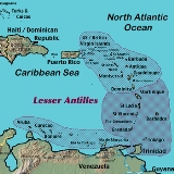
Lesser Antilles
Overview
The Lesser Antilles are a long, partly volcanic
island arc
in the Western Hemisphere
. Most of its islands form the eastern boundary of the Caribbean Sea
with the Atlantic Ocean
, with the remainder located in the southern Caribbean just north of South America
. The Lesser Antilles and the Greater Antilles
comprise the Antilles
, which are in turn part of the West Indies along with the Bahamas, the Cayman Islands
and the Turks and Caicos Islands
. The Lesser Antilles are also known as the Caribbees.
The islands of the Lesser Antilles are divided into three groups.
Volcanic arc
A volcanic arc is a chain of volcanoes positioned in an arc shape as seen from above. Offshore volcanoes form islands, resulting in a volcanic island arc. Generally they result from the subduction of an oceanic tectonic plate under another tectonic plate, and often parallel an oceanic trench...
island arc
Island arc
An island arc is a type of archipelago composed of a chain of volcanoes which alignment is arc-shaped, and which are situated parallel and close to a boundary between two converging tectonic plates....
in the Western Hemisphere
Western Hemisphere
The Western Hemisphere or western hemisphere is mainly used as a geographical term for the half of the Earth that lies west of the Prime Meridian and east of the Antimeridian , the other half being called the Eastern Hemisphere.In this sense, the western hemisphere consists of the western portions...
. Most of its islands form the eastern boundary of the Caribbean Sea
Caribbean Sea
The Caribbean Sea is a sea of the Atlantic Ocean located in the tropics of the Western hemisphere. It is bounded by Mexico and Central America to the west and southwest, to the north by the Greater Antilles, and to the east by the Lesser Antilles....
with the Atlantic Ocean
Atlantic Ocean
The Atlantic Ocean is the second-largest of the world's oceanic divisions. With a total area of about , it covers approximately 20% of the Earth's surface and about 26% of its water surface area...
, with the remainder located in the southern Caribbean just north of South America
South America
South America is a continent situated in the Western Hemisphere, mostly in the Southern Hemisphere, with a relatively small portion in the Northern Hemisphere. The continent is also considered a subcontinent of the Americas. It is bordered on the west by the Pacific Ocean and on the north and east...
. The Lesser Antilles and the Greater Antilles
Greater Antilles
The Greater Antilles are one of three island groups in the Caribbean. Comprising Cuba, Jamaica, Hispaniola , and Puerto Rico, the Greater Antilles constitute almost 90% of the land mass of the entire West Indies.-Greater Antilles in context :The islands of the Caribbean Sea, collectively known as...
comprise the Antilles
Antilles
The Antilles islands form the greater part of the West Indies in the Caribbean Sea. The Antilles are divided into two major groups: the "Greater Antilles" to the north and west, including the larger islands of Cuba, Jamaica, Hispaniola , and Puerto Rico; and the smaller "Lesser Antilles" on the...
, which are in turn part of the West Indies along with the Bahamas, the Cayman Islands
Cayman Islands
The Cayman Islands is a British Overseas Territory and overseas territory of the European Union located in the western Caribbean Sea. The territory comprises the three islands of Grand Cayman, Cayman Brac, and Little Cayman, located south of Cuba and northwest of Jamaica...
and the Turks and Caicos Islands
Turks and Caicos Islands
The Turks and Caicos Islands are a British Overseas Territory and overseas territory of the European Union consisting of two groups of tropical islands in the Caribbean, the larger Caicos Islands and the smaller Turks Islands, known for tourism and as an offshore financial centre.The Turks and...
. The Lesser Antilles are also known as the Caribbees.
The islands of the Lesser Antilles are divided into three groups.
Discussions
Encyclopedia
The Lesser Antilles are a long, partly volcanic
island arc
in the Western Hemisphere
. Most of its islands form the eastern boundary of the Caribbean Sea
with the Atlantic Ocean
, with the remainder located in the southern Caribbean just north of South America
. The Lesser Antilles and the Greater Antilles
comprise the Antilles
, which are in turn part of the West Indies along with the Bahamas, the Cayman Islands
and the Turks and Caicos Islands
. The Lesser Antilles are also known as the Caribbees.
in the south and the Leeward Islands
in the north. The Windward Islands are called such because they were more windward to sailing ships arriving in the New World than the Leeward Islands, given that the prevailing trade winds blow east to west. The trans-Atlantic currents and winds that provided the fastest route across the ocean brought these ships to the rough dividing line between the Windward and Leeward Islands.
The third group is the Leeward Antilles
in the west. These consist of the Dutch
ABC islands just off the coast of Venezuela
, plus a group of Venezuelan islands.
. Many of the islands were formed as a result of the subduction
of oceanic crust of the North American Plate under the Caribbean Plate in the Lesser Antilles subduction zone
. This process is ongoing and is responsible not only for many of the islands, but also for volcanic and earthquake activity in the region. The islands along the South American coast are largely the result of the interaction of the South American Plate
and the Caribbean Plate which is mainly strike-slip, but includes a component of compression.
The main Lesser Antilles are (from north to south to west):
Leeward Islands
:
Windward Islands
:
Leeward Antilles
– islands north of the Venezuela
n coast (from west to east):
Volcanic arc
A volcanic arc is a chain of volcanoes positioned in an arc shape as seen from above. Offshore volcanoes form islands, resulting in a volcanic island arc. Generally they result from the subduction of an oceanic tectonic plate under another tectonic plate, and often parallel an oceanic trench...
island arc
Island arc
An island arc is a type of archipelago composed of a chain of volcanoes which alignment is arc-shaped, and which are situated parallel and close to a boundary between two converging tectonic plates....
in the Western Hemisphere
Western Hemisphere
The Western Hemisphere or western hemisphere is mainly used as a geographical term for the half of the Earth that lies west of the Prime Meridian and east of the Antimeridian , the other half being called the Eastern Hemisphere.In this sense, the western hemisphere consists of the western portions...
. Most of its islands form the eastern boundary of the Caribbean Sea
Caribbean Sea
The Caribbean Sea is a sea of the Atlantic Ocean located in the tropics of the Western hemisphere. It is bounded by Mexico and Central America to the west and southwest, to the north by the Greater Antilles, and to the east by the Lesser Antilles....
with the Atlantic Ocean
Atlantic Ocean
The Atlantic Ocean is the second-largest of the world's oceanic divisions. With a total area of about , it covers approximately 20% of the Earth's surface and about 26% of its water surface area...
, with the remainder located in the southern Caribbean just north of South America
South America
South America is a continent situated in the Western Hemisphere, mostly in the Southern Hemisphere, with a relatively small portion in the Northern Hemisphere. The continent is also considered a subcontinent of the Americas. It is bordered on the west by the Pacific Ocean and on the north and east...
. The Lesser Antilles and the Greater Antilles
Greater Antilles
The Greater Antilles are one of three island groups in the Caribbean. Comprising Cuba, Jamaica, Hispaniola , and Puerto Rico, the Greater Antilles constitute almost 90% of the land mass of the entire West Indies.-Greater Antilles in context :The islands of the Caribbean Sea, collectively known as...
comprise the Antilles
Antilles
The Antilles islands form the greater part of the West Indies in the Caribbean Sea. The Antilles are divided into two major groups: the "Greater Antilles" to the north and west, including the larger islands of Cuba, Jamaica, Hispaniola , and Puerto Rico; and the smaller "Lesser Antilles" on the...
, which are in turn part of the West Indies along with the Bahamas, the Cayman Islands
Cayman Islands
The Cayman Islands is a British Overseas Territory and overseas territory of the European Union located in the western Caribbean Sea. The territory comprises the three islands of Grand Cayman, Cayman Brac, and Little Cayman, located south of Cuba and northwest of Jamaica...
and the Turks and Caicos Islands
Turks and Caicos Islands
The Turks and Caicos Islands are a British Overseas Territory and overseas territory of the European Union consisting of two groups of tropical islands in the Caribbean, the larger Caicos Islands and the smaller Turks Islands, known for tourism and as an offshore financial centre.The Turks and...
. The Lesser Antilles are also known as the Caribbees.
Regional terminology
The islands of the Lesser Antilles are divided into three groups. The two main groups are the Windward IslandsWindward Islands
The Windward Islands are the southern islands of the Lesser Antilles, within the West Indies.-Name and geography:The Windward Islands are called such because they were more windward to sailing ships arriving in the New World than the Leeward Islands, given that the prevailing trade winds in the...
in the south and the Leeward Islands
Leeward Islands
The Leeward Islands are a group of islands in the West Indies. They are the northern islands of the Lesser Antilles chain. As a group they start east of Puerto Rico and reach southward to Dominica. They are situated where the northeastern Caribbean Sea meets the western Atlantic Ocean...
in the north. The Windward Islands are called such because they were more windward to sailing ships arriving in the New World than the Leeward Islands, given that the prevailing trade winds blow east to west. The trans-Atlantic currents and winds that provided the fastest route across the ocean brought these ships to the rough dividing line between the Windward and Leeward Islands.
The third group is the Leeward Antilles
Leeward Antilles
The Leeward Antilles are a chain of islands in the Caribbean – specifically, the southerly islands of the Lesser Antilles along the southeastern fringe of the Caribbean Sea, just north of the Venezuelan coast of the South American mainland...
in the west. These consist of the Dutch
Kingdom of the Netherlands
The Kingdom of the Netherlands is a sovereign state and constitutional monarchy with territory in Western Europe and in the Caribbean. The four parts of the Kingdom—Aruba, Curaçao, the Netherlands, and Sint Maarten—are referred to as "countries", and participate on a basis of equality...
ABC islands just off the coast of Venezuela
Venezuela
Venezuela , officially called the Bolivarian Republic of Venezuela , is a tropical country on the northern coast of South America. It borders Colombia to the west, Guyana to the east, and Brazil to the south...
, plus a group of Venezuelan islands.
Geology
The Lesser Antilles more or less coincide with the outer edge of the Caribbean PlateCaribbean Plate
The Caribbean Plate is a mostly oceanic tectonic plate underlying Central America and the Caribbean Sea off the north coast of South America....
. Many of the islands were formed as a result of the subduction
Subduction
In geology, subduction is the process that takes place at convergent boundaries by which one tectonic plate moves under another tectonic plate, sinking into the Earth's mantle, as the plates converge. These 3D regions of mantle downwellings are known as "Subduction Zones"...
of oceanic crust of the North American Plate under the Caribbean Plate in the Lesser Antilles subduction zone
Lesser Antilles subduction zone
The Lesser Antilles subduction zone is a convergent plate boundary on the seafloor along the eastern margin of the Lesser Antilles island arc. In this subduction zone, oceanic crust of the South American Plate is being subducted under the Caribbean Plate....
. This process is ongoing and is responsible not only for many of the islands, but also for volcanic and earthquake activity in the region. The islands along the South American coast are largely the result of the interaction of the South American Plate
South American Plate
The South American Plate is a continental tectonic plate which includes the continent of South America and also a sizeable region of the Atlantic Ocean seabed extending eastward to the Mid-Atlantic Ridge....
and the Caribbean Plate which is mainly strike-slip, but includes a component of compression.
Sovereign states
Name | Subdivisions | Area (km²) |
Population (1 July 2005 est.) |
Population density (per km²) |
Capital |
---|---|---|---|---|---|
![]() |
Parishes Parishes and dependencies of Antigua and Barbuda Antigua and Barbuda is an island nation made up of Antigua, which, along with its satellite islets and rocks, is divided into six parishes; and two dependencies, the islands Barbuda and Redonda.... |
440 | 195 | St. John's St. John's, Antigua and Barbuda St John's is the capital and largest city of Antigua and Barbuda, a country located in the West Indies in the Caribbean Sea. St John's is located at... |
|
![]() |
Barbuda Barbuda Barbuda is an island in the Eastern Caribbean, and forms part of the state of Antigua and Barbuda. It has a population of about 1,500, most of whom live in the town of Codrington.-Location:... |
161 | 9.65 | Codrington | |
![]() |
Redonda Redonda Redonda is a very small, uninhabited Caribbean island which is part of Antigua and Barbuda, in the Leeward Islands, West Indies.This small island lies southwest of Antigua, in the waters between the islands of Nevis and Montserrat... |
0 | 0 | n/a N/A n/a, which uses lowercase letters, is a common abbreviation for not applicable or not available, used to indicate when information in a certain field on a table is not provided, either because it does not apply to a particular case in question or because it is not available... |
|
Parishes Parishes of Barbados The country of Barbados is currently subdivided into sub-regions known as parishes. According to the Act of the Barbados Parliament they are officially styled as the "Parish of as opposed to the U.S. styled naming convention with the name "Parish" coming after the name... |
431 | 660 | Bridgetown Bridgetown The city of Bridgetown , metropolitan pop 96,578 , is the capital and largest city of the nation of Barbados. Formerly, the Town of Saint Michael, the Greater Bridgetown area is located within the parish of Saint Michael... |
||
Parishes Parishes of Dominica -See also:*ISO 3166-2:DM... |
96.3 | Roseau Roseau -Architecture:The central district of Roseau is tightly packed with small and large houses and even larger modern concrete structures. There is little green or open space situated within the city, and this is even more so today, as many of the courtyards which was once commonplace within the city... |
|||
Parishes Parishes of Grenada |The Caribbean island country of Grenada is subdivided into sub-regions known as parishes.A parish defines a territorial unit or region that, historically, was usually an area under the pastoral care served by a local church as an ecclesiastical administrative unit and later used by map-makers to... |
319.8 | St. George’s St. George's, Grenada St. George's, population 89,018 , with an agglomeration of 4,500 people , is the capital of Grenada, . The city is surrounded by a hillside of an old volcano crater and is on a horseshoe-shaped harbor.... |
|||
![]() |
Parishes Parishes of Saint Kitts and Nevis The Federation of Saint Kitts and Nevis is divided into 14 parishes. Nine parishes are located on the island of Saint Kitts and five on Nevis. The parishes are drawn like pie-slices from the ridgeline of the central mountains of both islands.... |
261 | 163.5 | Basseterre Basseterre Basseterre , estimated population 15,500 in 2000, is the capital of the Federation of Saint Kitts and Nevis in the West Indies. Geographically, the Basseterre port is located at , on the south western coast of Saint Kitts Island, and it is one of the chief commercial depots of the Leeward Islands... |
|
![]() |
![]() |
93 | 130.1 | Charlestown Charlestown, Saint Kitts and Nevis Charlestown is the capital of the island of Nevis, in the Federation of Saint Kitts and Nevis, Leeward Islands, West Indies. Charlestown is situated on the leeward side of the island of Nevis, near the southern end of Pinneys Beach.... |
|
![]() |
Quarters Quarters of Saint Lucia ||The island of Saint Lucia is divided into 11 quarters:# Anse la Raye# Castries# Choiseul# Dauphin# Dennery# Gros Islet# Laborie# Micoud# Praslin# Soufrière# Vieux Fort-District statistics:... |
616 | 282 | Castries Castries Castries , population 10,634, aggl. 37,963 , is the capital city of Saint Lucia, a country in the Caribbean. The district with the same name had a population of 61,341 in 2001-05-22, and stretches over an area of .... |
|
![]() |
Parishes Parishes of Saint Vincent and the Grenadines ||Saint Vincent and the Grenadines is divided into six parishes.Five parishes are on the island of Saint Vincent, while the Grenadines Parish include the northern two-thirds of the Grenadines.-External links:* , Statoids.com... |
389 | 308.4 | Kingstown Kingstown Kingstown is the chief port of Saint Vincent, and the capital of Saint Vincent and the Grenadines. With a population of 25,418 Kingstown is a centre for the island's agricultural industry and a port of entry for tourists... |
|
![]() |
Regional corporations Regional Corporations and Municipalities of Trinidad and Tobago -Trinidad:Historically, Trinidad was divided into eight counties.-Tobago:Tobago is governed locally by the Tobago House of Assembly.Historically, Tobago was divided into seven parishes . In 1768 each parish of Tobago had nominated representatives to the Tobago House of Assembly... |
253.3 | Port of Spain Port of Spain Port of Spain, also written as Port-of-Spain, is the capital of the Republic of Trinidad and Tobago and the country's third-largest municipality, after San Fernando and Chaguanas. The city has a municipal population of 49,031 , a metropolitan population of 128,026 and a transient daily population... |
||
![]() |
Tobago Tobago Tobago is the smaller of the two main islands that make up the Republic of Trinidad and Tobago. It is located in the southern Caribbean, northeast of the island of Trinidad and southeast of Grenada. The island lies outside the hurricane belt... |
300 | 180 | Scarborough Scarborough, Tobago Scarborough, Tobago is the largest town in Tobago, one of the two main islands of the Republic of Trinidad and Tobago. Its population is around 17,000, almost one-third of the population of the island. The town is dominated by Fort King George, an 18th century fortification named after King George... |
Non-sovereign territories
Name | Subdivisions | Area (km²) |
Population (1 July 2005 est.) |
Population density (per km²) |
Capital |
---|---|---|---|---|---|
![]() |
null | 193 | 534 | Oranjestad Oranjestad, Aruba Oranjestad is the capital and largest city of Aruba, which is in the Caribbean north of Venezuela. Oranjestad is located on the southern coast near the western end of the island country... |
|
![]() |
91 | 132 | The Valley The Valley, Anguilla -Population:-References:... |
||
![]() |
null | 288 | 246.3 | Kralendijk Kralendijk Kralendijk is the capital city and main port of the island of Bonaire in the Caribbean Netherlands. The language spoken in the town is Papiamentu, but Dutch and English are widely used. In Dutch, Kralendijk means "coral reef" or "coral dike". The Papiamentu name for the town is Playa or "beach"... |
|
Districts Districts of the British Virgin Islands -Administrative Districts:The five administrative subdivisions mentioned on some web pages may just be planning regions, without much administrative relevance:... |
153 | 260 | Road Town Road Town -See also:* Government House, the official residence of the Governor of the British Virgin Islands located in Road Town-External links:*****... |
||
![]() |
null | 444 | 406.7 | Willemstad Willemstad, Netherlands Antilles Willemstad is the capital city of Curaçao, an island in the southern Caribbean Sea that forms a constituent country of the Kingdom of the Netherlands. Formerly the capital of the Netherlands Antilles prior to its dissolution in 2010, it has an estimated population of 140,000. The historic centre of... |
|
![]() |
Arrondissements | 249.1 | Basse-Terre Basse-Terre Basse-Terre is the prefecture of Guadeloupe, an overseas region and department of France located in the Lesser Antilles... |
||
![]() |
Arrondissements | Fort-de-France Fort-de-France Fort-de-France is the capital of France's Caribbean overseas department of Martinique. It is also one of the major cities in the Caribbean. Exports include sugar, rum, tinned fruit, and cacao.-Geography:... |
|||
![]() |
Brades Brades Brades is a village and de facto capital of the Caribbean island of Montserrat since 1998. Brades is located in the Carr's Bay/Little Bay vicinity at the northwest end of Montserrat. The official capital Plymouth in the south of the island has been abandoned since 1997 due to the eruption of... |
||||
![]() |
null | 13 | 109.5 | The Bottom The Bottom The Bottom is the capital and largest town of the island of Saba, the Caribbean Netherlands, and is the first stop on the way from Saba's Port in Fort Bay towards the rest of the island... |
|
![]() |
null | 21 | 354.6 | Gustavia | |
null | 53 | 675 | Marigot Marigot, Saint Martin Marigot is the main town and capital on the French side of the Caribbean island of Saint Martin.-History and features:Originally a fishing village on a swamp for which it was named, Marigot was made capital during the reign of King Louis XVI, who built Fort St. Louis on a hill near Marigot Bay... |
||
![]() |
null | 34 | 147.6 | Oranjestad Oranjestad, Sint Eustatius Oranjestad is a small town of nearly 1,000 inhabitants, and is the capital of Sint Eustatius island in the Caribbean Netherlands.Oranjestad is a historic harbour town... |
|
![]() |
null | 34 | 1,704 | Philipsburg Philipsburg, Netherlands Antilles Philipsburg is the main town and capital of the country of Sint Maarten, on a narrow stretch of land between Great Bay and the Great Salt Pond. It functions as the commercial center of Saint Martin island, whereof Sint Maarten encompasses the southern half... |
|
![]() |
Districts Districts and sub-districts of the United States Virgin Islands The United States Virgin Islands are administratively divided into 3 districts, which are subdivided into 20 subdistricts.The districts are:# Saint Croix# Saint Thomas# Saint John... |
346 | 313.1 | Charlotte Amalie Charlotte Amalie, United States Virgin Islands -Education:St. Thomas-St. John School District serves the community. and Charlotte Amalie High School serve the area.-Gallery:-See also:* Anna's Retreat* Cruz Bay* Saint Thomas* Water Island-External links:* *... |
Islands

Leeward Islands
Leeward Islands
The Leeward Islands are a group of islands in the West Indies. They are the northern islands of the Lesser Antilles chain. As a group they start east of Puerto Rico and reach southward to Dominica. They are situated where the northeastern Caribbean Sea meets the western Atlantic Ocean...
:
- Virgin IslandsVirgin IslandsThe Virgin Islands are the western island group of the Leeward Islands, which are the northern part of the Lesser Antilles, which form the border between the Caribbean Sea and the Atlantic Ocean...
- St. Thomas (USA)
- St. John (USA)
- St. Croix (USA)
- Water Island (USA)
- TortolaTortolaTortola is the largest and most populated of the British Virgin Islands, a group of islands that form part of the archipelago of the Virgin Islands. Local tradition recounts that Christopher Columbus named it Tortola, meaning "land of the Turtle Dove". Columbus named the island Santa Ana...
(UK) - Virgin GordaVirgin GordaVirgin Gorda is the third-largest and second most populous of the British Virgin Islands . Located at approximately 18 degrees, 48 minutes North, and 64 degrees, 30 minutes West, it covers an area of about...
(UK) - AnegadaAnegadaAnegada is the northernmost of the British Virgin Islands, a group of islands which form part of the archipelago of the Virgin Islands. It lies approximately north of Virgin Gorda. Anegada is the only inhabited British Virgin Island formed from coral and limestone, rather than being of volcanic...
(UK) - Jost Van DykeJost Van DykeAt roughly 8 square kilometers, and about 3 square miles Jost Van Dyke is the smallest of the four main islands of the British Virgin Islands, the northern portion of the archipelago of the Virgin Islands, located in the Atlantic Ocean and Caribbean Sea. Jost Van Dyke lies about 8 km to the...
(UK)
- AnguillaAnguillaAnguilla is a British overseas territory and overseas territory of the European Union in the Caribbean. It is one of the most northerly of the Leeward Islands in the Lesser Antilles, lying east of Puerto Rico and the Virgin Islands and directly north of Saint Martin...
(UK) - Saint Martin/Sint MaartenSaint MartinSaint Martin is an island in the northeast Caribbean, approximately east of Puerto Rico. The 87 km2 island is divided roughly 60/40 between France and the Kingdom of the Netherlands ; however, the Dutch side has the larger population. It is one of the smallest sea islands divided between...
(France/Neth.) - Saint-Barthélemy (Fr.)
- Saba (Neth.)
- Sint Eustatius (Neth.)
- Saint KittsSaint KittsSaint Kitts Saint Kitts Saint Kitts (also known more formally as Saint Christopher Island (Saint-Christophe in French) is an island in the West Indies. The west side of the island borders the Caribbean Sea, and the eastern coast faces the Atlantic Ocean...
(St. Kitts and Nevis) - NevisNevisNevis is an island in the Caribbean Sea, located near the northern end of the Lesser Antilles archipelago, about 350 km east-southeast of Puerto Rico and 80 km west of Antigua. The 93 km² island is part of the inner arc of the Leeward Islands chain of the West Indies...
(St. Kitts and Nevis) - BarbudaBarbudaBarbuda is an island in the Eastern Caribbean, and forms part of the state of Antigua and Barbuda. It has a population of about 1,500, most of whom live in the town of Codrington.-Location:...
(Antigua and Barbuda) - AntiguaAntiguaAntigua , also known as Waladli, is an island in the West Indies, in the Leeward Islands in the Caribbean region, the main island of the country of Antigua and Barbuda. Antigua means "ancient" in Spanish and was named by Christopher Columbus after an icon in Seville Cathedral, Santa Maria de la...
(Antigua and Barbuda) - RedondaRedondaRedonda is a very small, uninhabited Caribbean island which is part of Antigua and Barbuda, in the Leeward Islands, West Indies.This small island lies southwest of Antigua, in the waters between the islands of Nevis and Montserrat...
(Antigua and Barbuda) - MontserratMontserratMontserrat is a British overseas territory located in the Leeward Islands, part of the chain of islands called the Lesser Antilles in the West Indies. This island measures approximately long and wide, giving of coastline...
(UK) - GuadeloupeGuadeloupeGuadeloupe is an archipelago located in the Leeward Islands, in the Lesser Antilles, with a land area of 1,628 square kilometres and a population of 400,000. It is the first overseas region of France, consisting of a single overseas department. As with the other overseas departments, Guadeloupe...
(Fr.) - La DésiradeLa DésiradeLa Désirade is a French West Indies island located at the eastern of Guadeloupe, in the Lesser Antilles.It has a land area of 20.64 km² and a population of 1,595 in 2006 , with a population density of 77 inh. per km² in 2006...
(Fr.) - Marie-GalanteMarie-GalanteMarie-Galante is an island of the Caribbean Sea located at the south of Guadeloupe and at north of Dominica. Marie-Galante is a dependence of Guadeloupe which is a french overseas department....
(Fr.) - les Saintes archipelagoÎles des SaintesThe Îles des Saintes , also called simply Les Saintes , is a small archipelago of French Antilles located in the South of Basse-Terre Island, on the West of Marie-Galante and in the North of Dominica in the arc of Lesser Antilles...
(Fr.) - DominicaDominicaDominica , officially the Commonwealth of Dominica, is an island nation in the Lesser Antilles region of the Caribbean Sea, south-southeast of Guadeloupe and northwest of Martinique. Its size is and the highest point in the country is Morne Diablotins, which has an elevation of . The Commonwealth...
(Dominica)
Windward Islands
Windward Islands
The Windward Islands are the southern islands of the Lesser Antilles, within the West Indies.-Name and geography:The Windward Islands are called such because they were more windward to sailing ships arriving in the New World than the Leeward Islands, given that the prevailing trade winds in the...
:
- MartiniqueMartiniqueMartinique is an island in the eastern Caribbean Sea, with a land area of . Like Guadeloupe, it is an overseas region of France, consisting of a single overseas department. To the northwest lies Dominica, to the south St Lucia, and to the southeast Barbados...
(Fr.) - Saint LuciaSaint LuciaSaint Lucia is an island country in the eastern Caribbean Sea on the boundary with the Atlantic Ocean. Part of the Lesser Antilles, it is located north/northeast of the island of Saint Vincent, northwest of Barbados and south of Martinique. It covers a land area of 620 km2 and has an...
(St. Lucia) - Saint VincentSaint Vincent (island)Saint Vincent is a volcanic island in the Caribbean. It is the largest island of the chain called Saint Vincent and the Grenadines. It is located in the Caribbean Sea, between Saint Lucia and Grenada. It is composed of partially submerged volcanic mountains...
(St. Vincent and the Grenadines) - GrenadinesGrenadinesThe Grenadines is a Caribbean island chain of over 600 islands in the Windward Islands.-Geographic boundaries:They are divided between the island nations of Saint Vincent and the Grenadines and Grenada. They lie between the islands of Saint Vincent in the north and Grenada in the south. Neither...
(St. Vincent and the Grenadines) - BarbadosBarbadosBarbados is an island country in the Lesser Antilles. It is in length and as much as in width, amounting to . It is situated in the western area of the North Atlantic and 100 kilometres east of the Windward Islands and the Caribbean Sea; therein, it is about east of the islands of Saint...
(Barbados is a Continental island found 100 miles (160.9 km) east of the Windward chain) - GrenadaGrenadaGrenada is an island country and Commonwealth Realm consisting of the island of Grenada and six smaller islands at the southern end of the Grenadines in the southeastern Caribbean Sea...
(Grenada) - TobagoTobagoTobago is the smaller of the two main islands that make up the Republic of Trinidad and Tobago. It is located in the southern Caribbean, northeast of the island of Trinidad and southeast of Grenada. The island lies outside the hurricane belt...
- TrinidadTrinidadTrinidad is the larger and more populous of the two major islands and numerous landforms which make up the island nation of Trinidad and Tobago. It is the southernmost island in the Caribbean and lies just off the northeastern coast of Venezuela. With an area of it is also the fifth largest in...
(Sometimes considered part of the Windward Islands. They are the most southern islands of the Caribbean region. Islands of Trinidad and TobagoIslands of Trinidad and TobagoThis is a list of islands of Trinidad and Tobago. Trinidad and Tobago is an archipelagic republic in the southern Caribbean.-Bocas Islands:The Bocas Islands lie between Trinidad and Venezuela, in the Bocas del Dragón...
Leeward Antilles
Leeward Antilles
The Leeward Antilles are a chain of islands in the Caribbean – specifically, the southerly islands of the Lesser Antilles along the southeastern fringe of the Caribbean Sea, just north of the Venezuelan coast of the South American mainland...
– islands north of the Venezuela
Venezuela
Venezuela , officially called the Bolivarian Republic of Venezuela , is a tropical country on the northern coast of South America. It borders Colombia to the west, Guyana to the east, and Brazil to the south...
n coast (from west to east):
- ArubaArubaAruba is a 33 km-long island of the Lesser Antilles in the southern Caribbean Sea, located 27 km north of the coast of Venezuela and 130 km east of Guajira Peninsula...
(Neth.) - CuraçaoCuraçaoCuraçao is an island in the southern Caribbean Sea, off the Venezuelan coast. The Country of Curaçao , which includes the main island plus the small, uninhabited island of Klein Curaçao , is a constituent country of the Kingdom of the Netherlands...
(Neth.) - Bonaire (Neth.)
- Los Roques ArchipelagoLos Roques ArchipelagoThe Los Roques islands are a federal dependency of Venezuela, consisting of about 350 islands, cays or islets. The archipelago is located 80 miles directly north of the port of La Guaira, and is a 40-minute flight, has a total area of 40.61 square kilometres.Being almost an untouched coral reef,...
(Ven) - La OrchilaLa OrchilaLa Orchila is a military base off the coast of Venezuela, north of Caracas. It has numerous beaches, including one where the sand is markedly pink ....
(Ven) - La TortugaLa Tortuga IslandLa Tortuga Island is an uninhabited island dependent on the government of Venezuela. It is part of a chain of islands that include the Tortuguillas, the Palaquines, and others. Has an area of 156 km²-History:...
(Ven) - La BlanquillaBlanquilla IslandBlanquilla is an island, one of the federal dependencies of Venezuela, located in the southeastern Caribbean Sea about 182 miles northeast of Caracas. It is a popular location for divers, as well as famous for its white sand beaches, for which it is named. The island's wildlife include local cacti...
(Ven) - Margarita Island (Ven)
- Coche (Ven)
- CubaguaCubaguaCubagua or Isla de Cubagua is the smallest and least populated of the three islands constituting the Venezuelan state of Nueva Esparta, after Isla Margarita and Coche. It is located 16 km north of Araya Peninsula, the closest mainland area....
(Ven) - Other islandsFederal dependencies of VenezuelaThe Federal Dependencies of Venezuela encompass all of Venezuela's off shore islands in the Caribbean Sea and the Gulf of Venezuela...
(Ven)