
Hurricane Camille
Encyclopedia
Hurricane Camille was the third and strongest tropical cyclone and second hurricane during the 1969 Atlantic hurricane season
. The second of three catastrophic Category 5
hurricanes to make landfall
in the United States during the 20th century (the others being 1935
's Labor Day hurricane and 1992
's Hurricane Andrew
), which it did near the mouth of the Mississippi River
on the night of August 17. Camille and unofficially the Labor Day Hurricane were the only Atlantic hurricanes to exhibit recorded sustained wind speeds of at least 190 miles per hour (305.8 km/h) until Allen
joined the club in 1980, and remains the only confirmed Atlantic hurricane in recorded history to make landfall with wind speeds at or above such a level. By central pressure, in turn, Camille was the second strongest U.S. landfalling hurricane in recorded history, second only to the Labor Day Hurricane in 1935. It was also the first modern Category 5 hurricane to ever receive a person's name when making landfall in the United States.
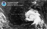
The storm formed on August 14 and rapidly deepened
. It scraped the western edge of Cuba
at Category 3
intensity. Camille strengthened further over the Gulf of Mexico and made landfall with a pressure of 905 mbar
(hPa
), estimated sustained winds of 190 mph (305 km/h), and a peak official storm surge
of 24 feet (7.3 m); by maximum sustained wind speeds, Camille was one of the strongest landfalling tropical cyclones recorded worldwide, and one of only four tropical cyclones worldwide ever to officially achieve wind speeds of 190 miles per hour (305.8 km/h). The hurricane flattened nearly everything along the coast of the U.S. state
of Mississippi
, and caused additional flooding and deaths inland while crossing the Appalachian Mountains
of Virginia
. In total, Camille killed 259 people and caused $1.42 billion (1969 USD
, $ USD) in damages. To this day, a complete understanding of the reasons for the system's power, extremely rapid intensification over open water and strength at landfall has not been achieved.
off the western coast of Africa
on August 5. It tracked nearly due westward, eventually becoming clearly identifiable on satellite imagery on August 9. By that time, the thunderstorm activity concentrated into a circular area of convection. The next day, it moved through the Lesser Antilles
, although there was no evidence of a closed circulation
. On August 13, the wave passed near or over the southern coast of Jamaica
as its convection spread northeastward through the Bahamas. Subsequently it began a slower motion to the northwest. On August 14, the Hurricane Hunters
flew to investigate for a closed circulation near the Bahamas as well as near the Cayman Islands
. The crew observed a developing center in the western Caribbean, and winds quickly reached tropical storm status. It is estimated Tropical Storm Camille developed late on August 14 with winds of 60 mph (95 km/h), about 50 miles (80 km) west-northwest of Grand Cayman
.
Upon first being classified as a tropical cyclone, Camille was located in an area favorable for further strengthening, although initially it slowly intensified. It was located within an area of very light wind shear
and an overall warm environment. Additionally, the storm developed strong low-level inflow from the deep southern Caribbean, which continuously brought moisture into the storm. Throughout its duration, it was a small tropical cyclone, although with a radius of gale force winds spreading 100 miles (160 km) to the north, the storm's thunderstorm area quickly spread over Cuba. As the storm approached the western coast of Cuba, it began rapid deepening
, reaching hurricane status and less than 12 hours later attaining major hurricane status
, or winds of 115 mph (185 km/h). Prior to landfall
, its eye
was tracked by radar
from Havana
; it is estimated the hurricane moved ashore between Cape San Antonio
and Guane
late on August 15 as a major hurricane. Camille was a small hurricane as it crossed western Cuba, and its winds decreased to 105 mph (170 km/h) before it emerged into the Gulf of Mexico.
 Initially, Hurricane Camille was forecast to turn northeastward toward the Florida panhandle
. Instead, it continued northwestward and rapidly intensified. Its eye contracted to a diameter of less than 8 miles (13 km), and strong rainbands
developed around the entire hurricane. Due to the small eye, Hurricane Hunters at first had difficulties in obtaining the strength; however a flight late on August 16 recorded a very low pressure of 908 mbar
, with winds estimated at 150 mph (240 km/h). At the time, it was not expected to intensify further. However, a subsequent Hurricane Hunters flight early on August 17 recorded a pressure of 905 mbar, at the time the lowest pressure recorded by reconnaissance aircraft. Additionally, the winds of the hurricane were estimated at 160 mph (260 km/h), making Camille the equivalent of a Category 5 hurricane on the Saffir-Simpson Hurricane Scale
, which had not been developed at the time. That made Camille the most intense hurricane since the 1935 Labor Day Hurricane; currently it is tied for the seventh most intense Atlantic hurricane, as ranked by lowest pressure.
As it continued toward the Gulf Coast of the United States
, Camille maintained its small eye, and forecasters continued to anticipate a turn toward Florida. Late on August 17, a reconnaissance flight was forced to end its mission early due to a damaged engine. Before it left the storm, the crew recorded a pressure of 909 mbar and estimated surface winds at 190 mph (305 km/h), while Camille was located about 100 miles (160 km) southeast of the Mississippi River Delta
. There were no subsequent Hurricane Hunter flights, but it is estimated the hurricane maintained much of its intensity. After passing very near southeastern Louisiana, Hurricane Camille made landfall late on August 17 on southern Mississippi, near Bay St. Louis
and Pass Christian
. Maximum wind speeds near the coastline are unknown, but gusts were estimated to have approached 200 mph (325 km/h).
The hurricane rapidly weakened as it progressed inland, and within twelve hours of moving ashore, Camille weakened to tropical storm status. Shortly thereafter it weakened to tropical depression status, by which time it began a turn to the north and northeast. On August 20, the remnants of Camille turned eastward through Kentucky, dropping heavy rainfall in West Virginia and Virginia. Later that day it emerged into the Atlantic Ocean east of Norfolk
, and by August 21 it regained tropical storm status. Camille accelerated east-northeastward, attaining peak winds of 70 mph (115 km/h) as it interacted with larger Hurricane Debbie
to its southeast. Subsequently Camille began to interact with a cold front
, causing it to gradually change into an extratropical cyclone
as it entrained cooler air. On August 22, Camille was absorbed by the cold front to the south of Atlantic Canada
.
As Camille impacted Cuba, small craft were advised not to venture out too far from the coasts of Florida.
On August 15, the National Hurricane Center issued a hurricane watch for a 110 miles (177 km) stretch of land in Florida, between Apalachicola
and Fort Walton Beach
. The next day, as these hurricane watches were upgraded to a hurricane warning, thousands of people boarded up their homes and evacuated inland. During the afternoon of August 16, the weather bureau ordered that a hurricane watch should be placed in force for the coastline from Biloxi
to St Marks
, Florida. Later that day, the hurricane watches were upgraded to a hurricane warning for the northwestern Florida coast, from Fort Walton to St Marks.
By Saturday morning, a hurricane watch was issued for the coast from Biloxi eastward. Civil defense organizations in coastal counties went on alert. Keesler Air Force Base
and the Naval Construction Battalion Center prepared for the storm. By 5 p.m. Sunday, a hurricane warning was issued for the coast. This activated the National Guard units. Many refused to believe the reports concerning Camille's intensity that afternoon. Many people living at elevations of 20 feet (6.1 m) above sea level
refused to believe they were going to be submerged. The mayor of Gulfport
ordered the release of prisoners from the city jail as winds increased at 9 p.m. Sunday evening, but none would leave.
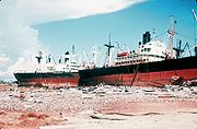
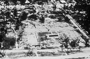
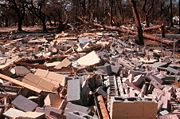
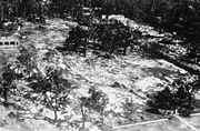
Making landfall as a Category 5 hurricane, Camille caused damage and destruction across much of the Gulf Coast of the United States
. Because it moved quickly through the region, Hurricane Camille dropped only moderate precipitation in most areas. Areas near its point of landfall reported from 7 inches (177.8 mm) to 10 inches (254 mm). The area of total destruction in Harrison County, Mississippi
was 68 square miles (176.1 km²). The total estimated cost of damage was $1.42 billion (1969 USD
, $ USD). This made Camille the second-most expensive hurricane in the United States, up to that point (behind Hurricane Betsy
). The storm directly killed 143 people along Alabama
, Mississippi
, and Louisiana
. An additional 153 people perished as a result of catastrophic flooding in Nelson County, Virginia
and other areas nearby. In all, 8,931 people were injured, 5,662 homes were destroyed, and 13,915 homes experienced major damage, with many of the fatalities being coastal residents who had refused to evacuate.
, although there were no reports of damage. Stations in Cuba on the outer fringes of the storm reported winds of 50 mph (80 km/h). East of where it moved ashore, the city of Guane recorded winds of 92 mph (149 km/h), although no wind reports were taken in the landfall location. The hurricane produced up to 10 inches (255 mm) near Guane, as well as on the Isle of Pines. On the Isle of Pines, the storm inflicted damage to about 100 houses. Throughout Pinar del Río Province
, Camille caused heavy damage, primarily from river flooding; about 20,000 people were left homeless in the province. Strong winds downed trees and power lines, which caused power outages eastward through the capital city of Havana
. Initially, the government reported no casualties from the storm. Subsequent research indicated the hurricane killed five people in the country during its passage, and damage was estimated at $5 million (1969 USD
).
In the days after the storm struck Cuba, the government deployed medical teams to affected regions to provide typhoid vaccine shots. Officials noted the potential for the spread of disease, due to flooding from Camille as well as previously wet conditions.
In the open Gulf of Mexico
, the hurricane produced wave height
s of at least 70 feet (21 m), as measured by
Shell Oil Company
. Along the ocean floor, the storm created mudslides which lowered the ocean floor; its combination with strong waves and winds destroyed three oil platforms, including one that at the time was the deepest oil well. Property damages to the offshore oil industry were initially estimated at $100 million (1969 USD).
 The pressure fell to 27.8 inches of mercury (941.4 hPa) at Garden Island. Winds gusted to 125 miles per hour (201.2 km/h) at Slidell
as their pressure sank to 28.75 inches of mercury (973.6 hPa) on August 19. Almost total destruction was seen from Venice
to Buras. Ostrica Lock measured a storm surge of 16 feet (4.9 m). Water overwashed U.S. Highway 90 to a depth of 10 feet (3 m). The highest rainfall report from the state was 5.23 inches (132.8 mm) from Slidell. Camille caused about $322 million (1969 dollars) of damage in Louisiana.
Significantly worse than Hurricane Betsy
and a September 1947 hurricane
, electricity went out during Camille's approach to the Mississippi coastline. United States Highway 90 flooded as its storm surge overtopped seawalls, leaving a barge along the highway in Gulfport
. Fires consumed coastal communities, with the exceptions of Bay St. Louis
and Waveland
. Camille destroyed the antebellum
Trinity Episcopal church in Pass Christian
, taking 15 lives. The Dixie White House, where President Woodrow Wilson
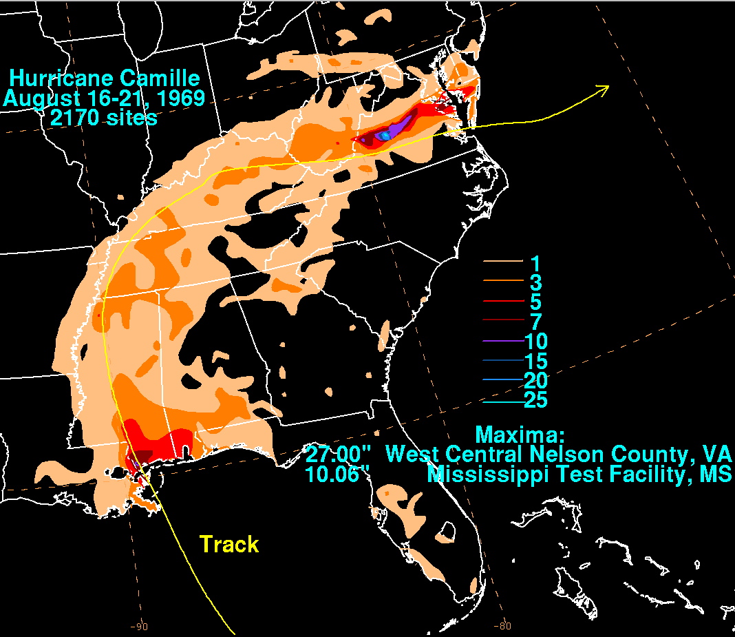
and his family once stayed, was badly damaged. In Biloxi, Mississippi
, the storm surge reached the second floor of the structure. The highest rainfall total recorded was 10.06 inches (255.5 mm) at the Mississippi Test Facility. Camille caused about $950 million (1969 dollars) of damage in Mississippi. Mississippi received the worst of the damage. Upon making landfall, Camille produced a 24 foot (7.3 m) storm surge. Along Mississippi's entire shore and for some three to four blocks inland, the destruction was nearly complete. The worst hit areas were Clermont Harbor
, Lakeshore
, Waveland
, Bay St. Louis
, Pass Christian
, Long Beach
, and the beach front of Gulfport
, Mississippi City
, and Biloxi
.
More than 11 inches (279.4 mm) of rain occurred in Hancock County
, and most low-lying areas were flooded with up to 15 feet (4.6 m) of water. U.S. Highway 90, which is close to the shore, was broken up in many areas, and sand and debris blocked much of it. Totals say that 3,800 homes and businesses were completely destroyed. As Camille came ashore, it passed over Ship Island
, off the coast of Mississippi; Camille's strong storm surge and torrential rains literally split the island in two: the body of water between West Ship Island and East Ship Island is now called "Camille's Cut".
In addition, one of Frank Lloyd Wright
's waterfront houses for W. L. Fuller, in Pass Christian, was completely destroyed by Hurricane Camille. Camille had significant ecological effects in the Gulf Coast region. A barrier island chain off the coast of Mississippi and 70% of Dauphin Island were completely inundated by the storm surge from Camille.
Alabama also experienced damage along U.S. Highway 90: 26,000 homes and over 1,000 businesses were wiped out completely across the state of Alabama. Camille's large circulation also resulted in a 3-to-5 foot (1-1.5 m) storm surge in Apalachicola, Florida
.
The highest rainfall report received within Alabama was 6.52 inches (165.6 mm) two miles northeast of Fairhope
. Camille caused about $8 million (1969 dollars) of damage in Alabama. Places farther east across the western Florida panhandle
saw lesser rains, as 4.16 inches (105.7 mm) was measured at Pensacola Naval Air Station.

 One persistent account about Camille states that a hurricane party was held on the third floor of the Richelieu Manor Apartments in Pass Christian, Mississippi
, in the path of the eyewall as it made landfall. The high storm surge flooded and destroyed the building, and there was only one survivor to tell of the story of the others. Who the survivor is, how many party guests there were, and just how far the sole survivor was swept by the storm varies with the retelling. An ABC
made-for-TV movie called Hurricane, starring Frank Sutton
of Gomer Pyle USMC, Larry Hagman
, Martin Milner
, and Michael Learned
, was loosely based on the supposed hurricane party. However, the site and names were changed to fictitious ones for the movie. The television show Quantum Leap carried an episode regarding the parties of Hurricane Camille and the actual hurricane itself. Survivor Ben Duckworth is quoted in Hurricane Camille: Monster Storm of the Gulf Coast as stating that the Richelieu was a designated civil defense
air-raid shelter
. However, their faith in the building's sturdiness was unfounded, as it was completely demolished by the storm. Twenty-three people are known to have stayed in the Richelieu Apartments during the hurricane, of whom eight died. The tale of the lone survivor and the party appears to have originated with survivor Mary Ann Gerlach. Other survivors, including Duckworth and Richard Keller, have expressed irritation at the story. "The hurricane party never happened, nor was the number of deaths associated with the apartment inhabitants accurate," says Pat Fitzpatrick, Mississippi State University
professor and author of Hurricanes: A Reference Handbook.
 Camille caused moderate rainfall in Tennessee
and Kentucky
of between 3 and 5 inches (127 mm), helping to relieve a drought in the area.
Yet in West Virginia
, there was flash flooding which destroyed 36 houses and 12 trailers, a total of three quarters of a million dollars in damage.
on the evening of August 19, Camille was no longer a hurricane, but it carried high amounts of moisture and contained sufficient strength and low pressure to pull in additional moisture.
Several places reportedly received over 8 inches (203.2 mm) of rain from Camille's remains, leading to significant flooding across the state. A total of 153 people lost their lives from blunt trauma
sustained during mountain slides, related to the flash flooding, not drowning. More than 123 of these deaths were in Nelson County. Debris avalanche
s occurred on hillsides with a slope greater than 35 percent. In Nelson County, the number of deaths amounted to over one percent of the county's population. The worst of the damage was reported in Massies Mill
, Woods Mill
, Roseland
, Bryant
, Tyro
, Montebello
, Lovingston
, Norwood, Rockfish
, and along the Davis and Muddy creeks. The James and Tye rivers crested well above flood stage in many areas, including a record high of 41.3 feet (12.6 m) at Columbia, Virginia
. Hurricane Camille caused more than $140 million of damage (1969 dollars) in Virginia. Camille was considered one of the worst natural disaster
s in central Virginia's recorded history.
The storm dropped torrential rainfall of 12 inches (304.8 mm) to 20 inches (508 mm), with a maximum of 27 inches (685.8 mm). Most of the rainfall occurred in Virginia during a 3-5 hour period on August 19–20. Five (5) plus inches of rain fell near the North Fork of the Tye River in only half an hour with the grounds already saturated from previous rains. Many rivers flooded across the state, with the worst being the James River
in Richmond
with a peak crest of 28.6 feet (8.7 m). Many rivers in Virginia and West Virginia set records for peak flood stages, causing numerous mudslides along mountainsides. In the mountain slopes between Charlottesville
and Lynchburg
, more than 26 inches (660.4 mm) of rain fell in 12 hours, but the worst was in Nelson County
where 27 inches (685.8 mm) fell. There, rainfall was so heavy that reports were received of birds drowning in trees, cows floating down the Hatt Creek and of survivors having to cup hands around their mouth and nose in order to breathe through the deluge.
The ensuing flash floods and mudslides killed 153 people. In Nelson County alone, 133 bridges washed out, while in some places entire communities were under water.
The major flooding that occurred downstream cut off all communication between Richmond and the Shenandoah Valley
. Waynesboro
on the South River
saw eight feet of water downtown, and Buena Vista
had more than five feet.
Throughout Virginia, Camille destroyed 313 houses, 71 trailers, and 430 farm buildings. 3,765 families were affected by the hurricane in the area, and total damage in the state amounted to $140.8 million (1969 USD, $747 million 2005 USD).
. A reconnaissance flight indicated a pressure of 901 hectopascals (26.6 inHg), but this pressure was not verified, and remains unofficial pending reanalysis. The wind speed of Camille can only be approximated, as no meteorological equipment survived the extreme conditions at landfall, but Camille is estimated to have had sustained winds of 190 miles per hour (305.8 km/h) at landfall, with gusts exceeding 200 miles per hour (321.9 km/h). Before Hurricane Katrina
in 2005, Camille likely had the highest storm surge
measured in the United States, at over 24 feet (7.3 m).
The 24 feet (7.3 m) storm surge quoted by the Army Corps of Engineers was based on high water marks inside surviving buildings, of which there were but three. Prior to the collapse of the Richelieu Apartments, Ben Duckworth shined a flashlight down a stairwell and found the water within one step of the third-story floor; this establishes a surge height of 28 feet (8.5 m) at that spot at that time. About 15 minutes later, the building collapsed and the evidence vanished with it.
In addition, Camille forced the Mississippi River
to flow backwards for a river-distance of 125 miles (from its mouth to a point north of New Orleans). The river further backed up for an additional 120 miles (193.1 km), to a point north of Baton Rouge
.
In 1969 the naming conventions for hurricanes were not strictly controlled as they are today. There were only three requirements: the name had to be female (male names were not used at that time), the names had to remain in alphabetical order, and the name could not have been retired. John Hope
, a meteorologist
at the National Hurricane Center
, had a daughter who had just graduated from high school. He added her name—Camille—to the list of storm names for the year, having no way of knowing that the storm bearing her name would become famous. Camille Hope is the wife of former U.S. Rep. Jim Marshall
of Georgia
.
 The response after the storm involved many federal, state, and local agencies and volunteer organizations. The main organization for coordinating the federal response to the disaster was the Office of Emergency Preparedness, which provided $76 million (1969 USD, $403 million 2005 USD) to administer and coordinate disaster relief programs. Food and shelter were available the day after the storm. On August 19, parts of Mississippi and Louisiana were declared major disaster areas and became eligible for federal disaster relief funds. President Richard M. Nixon ordered 1450 regular troops and 800 United States Army Engineers into the area to bring tons of food, vehicles, and aircraft.
Major organizations contributing to the relief effort included the Federal Power Commission, which helped fully return power to affected areas by November 25, 1969. The Coast Guard (then under the Department of Transportation), Air Force, Army, Army Corps of Engineers, Navy, and Marine Corps all helped with evacuations, search and rescue, clearing debris, and distribution of food. The Department of Defense contributed $34 million (1969 USD, $180 million 2005 USD) and 16,500 military troops overall to the recovery. The Department of Health provided 4 million dollars towards medicine, vaccines and other health related needs.
On Monday, the Air National Guard and those at Keesler Air Force Base airlifted patients to Jackson
and other more inland locations. Volunteers searched for those injured and dead, as well as helping refugees. When many of the evacuees returned by Tuesday, Governor John Bell Williams
declared martial law
, blocking highways into the area and leading to a 6 p.m. to 6 a.m. curfew. The governor also opened Camp Shelby
, dormitories within the University of Southern Mississippi, and the Robert E. Lee hotel to serve as shelters for those who lost homes. Sections of Bay St. Louis and Pass Christian were evacuated. Survivors were found for days after the storm, with 35 trapped by high water north of Bay St. Louis rescued on Thursday. Army engineers disposed of 25 tons of dead animals, mostly cows, during the week following Camille. One week after the storm, Keesler-based air planes sprayed malathion
at low altitudes to kill the thriving insect population. Martial law would be lifted on August 27. The federal and state military presence would continue for several weeks. During the evening of September 8, President Nixon visited the Biloxi-Gulfport Regional Airport and gave a speech to elevate the spirits of local residents struggling with the storm's aftermath. During the rebuilding process, stricter building codes were enforced by local governments. In 1973, hurricane hunters and their associated reconnaissance aircraft relocated to Keesler Air Force Base when their previous headquarters at Ramey, Puerto Rico, closed.
 Long-term redevelopment was overseen by the Department of Commerce, which contributed $30 million (1969 USD, $159 million 2005 USD) towards planned and coordinated redevelopment of affected areas.
The devastation of Camille inspired the implementation of the Saffir-Simpson Hurricane Scale
. After the storm, many Gulf Coast residents commented that hurricane warnings were not clear enough in conveying the expected intensity of the coming storm. The Saffir-Simpson scale offered a much more concise statement of storm intensity than barometric pressure and wind-speed measurements, and veterans of previous hurricanes could analogize the power of the approaching storm to those they had experienced.
In a 1999 report on Hurricane Camille sponsored by the NOAA Coastal Services Center, the authors concluded: "With Camille, the preparations for the event and the response were based on processes put in place long before the storm made landfall. Coordination between government agencies as well as with state and local officials was enhanced because of preexisting plans."
One small compensation was that recovery from flood damage in Nelson County, Virginia
led to the discovery of the Ginger Gold
apple in the orchards of Clyde Harvey.
 Although Hurricane Camille and Hurricane Katrina
took different paths, they both reached the same section of the coast of Mississippi with similar destructive effects. Camille intensified more rapidly than Katrina, and unlike Katrina, Camille maintained status as a Category 5 hurricane until landfall. However, the observed minimum pressure in Katrina was slightly lower. Both hurricanes shared the common aspect of undergoing periods of rapid intensification. The size of Camille's radius of maximum wind
was less than one-third that of Katrina, more similar to the intense but small Hurricane Andrew
. Also unlike Katrina, Camille caused little damage in New Orleans, Louisiana
, though Camille itself just barely missed the city. The area of hurricane-force winds within Camille was just over two-thirds the size of Hurricane Katrina. Both storms were moving at a similar forward motion at the time of landfall. Although Camille's wind speed at landfall was higher, Katrina's storm surge exceeded Camille's storm surge at all known locations due to its greater size. Both hurricanes' names were retired.
1969 Atlantic hurricane season
The 1969 Atlantic hurricane season officially began on June 1, 1969, and lasted until November 30, 1969. These dates conventionally delimit the period of each year when most tropical cyclones form in the Atlantic basin. The season was among the most active on record, with 18 tropical cyclones, 12...
. The second of three catastrophic Category 5
Saffir-Simpson Hurricane Scale
The Saffir–Simpson Hurricane Scale , or the Saffir–Simpson Hurricane Wind Scale , classifies hurricanes — Western Hemisphere tropical cyclones that exceed the intensities of tropical depressions and tropical storms — into five categories distinguished by the intensities of their sustained winds...
hurricanes to make landfall
Landfall (meteorology)
Landfall is the event of a tropical cyclone or a waterspout coming onto land after being over water. When a waterspout makes landfall it is reclassified as a tornado, which can then cause damage inland...
in the United States during the 20th century (the others being 1935
1935 Atlantic hurricane season
The 1935 Atlantic hurricane season ran from June 16 through October 31, 1935. The 1935 season featured below average activity, but it was eventful. A Category 1 hurricane in the Caribbean killed an estimated 2,150 people in the Greater Antilles and Central America. A Category 3 storm hit...
's Labor Day hurricane and 1992
1992 Atlantic hurricane season
The 1992 Atlantic hurricane season had one of the latest dates on record for the first named storm. The season officially began on June 1, 1992, and lasted until November 30, 1992. It was the least active hurricane season in nine years due to a strong El Niño...
's Hurricane Andrew
Hurricane Andrew
Hurricane Andrew was the third Category 5 hurricane to make landfall in the United States, after the Labor Day Hurricane of 1935 and Hurricane Camille in 1969. Andrew was the first named storm and only major hurricane of the otherwise inactive 1992 Atlantic hurricane season...
), which it did near the mouth of the Mississippi River
Mississippi River
The Mississippi River is the largest river system in North America. Flowing entirely in the United States, this river rises in western Minnesota and meanders slowly southwards for to the Mississippi River Delta at the Gulf of Mexico. With its many tributaries, the Mississippi's watershed drains...
on the night of August 17. Camille and unofficially the Labor Day Hurricane were the only Atlantic hurricanes to exhibit recorded sustained wind speeds of at least 190 miles per hour (305.8 km/h) until Allen
Hurricane Allen
Hurricane Allen was the first and strongest hurricane of the 1980 Atlantic hurricane season. It was one of the strongest hurricanes in recorded history, one of the few hurricanes to reach Category 5 status on the Saffir-Simpson Hurricane Scale on three separate occasions, and spent more time...
joined the club in 1980, and remains the only confirmed Atlantic hurricane in recorded history to make landfall with wind speeds at or above such a level. By central pressure, in turn, Camille was the second strongest U.S. landfalling hurricane in recorded history, second only to the Labor Day Hurricane in 1935. It was also the first modern Category 5 hurricane to ever receive a person's name when making landfall in the United States.
The storm formed on August 14 and rapidly deepened
Rapid deepening
Rapid deepening, also known as rapid intensification, is a meteorological condition that occurs when the minimum sea-level atmospheric pressure of a tropical cyclone decreases drastically in a short period of time. The National Weather Service describes rapid deepening as a decrease of...
. It scraped the western edge of Cuba
Cuba
The Republic of Cuba is an island nation in the Caribbean. The nation of Cuba consists of the main island of Cuba, the Isla de la Juventud, and several archipelagos. Havana is the largest city in Cuba and the country's capital. Santiago de Cuba is the second largest city...
at Category 3
Saffir-Simpson Hurricane Scale
The Saffir–Simpson Hurricane Scale , or the Saffir–Simpson Hurricane Wind Scale , classifies hurricanes — Western Hemisphere tropical cyclones that exceed the intensities of tropical depressions and tropical storms — into five categories distinguished by the intensities of their sustained winds...
intensity. Camille strengthened further over the Gulf of Mexico and made landfall with a pressure of 905 mbar
Bar (unit)
The bar is a unit of pressure equal to 100 kilopascals, and roughly equal to the atmospheric pressure on Earth at sea level. Other units derived from the bar are the megabar , kilobar , decibar , centibar , and millibar...
(hPa
Pascal (unit)
The pascal is the SI derived unit of pressure, internal pressure, stress, Young's modulus and tensile strength, named after the French mathematician, physicist, inventor, writer, and philosopher Blaise Pascal. It is a measure of force per unit area, defined as one newton per square metre...
), estimated sustained winds of 190 mph (305 km/h), and a peak official storm surge
Storm surge
A storm surge is an offshore rise of water associated with a low pressure weather system, typically tropical cyclones and strong extratropical cyclones. Storm surges are caused primarily by high winds pushing on the ocean's surface. The wind causes the water to pile up higher than the ordinary sea...
of 24 feet (7.3 m); by maximum sustained wind speeds, Camille was one of the strongest landfalling tropical cyclones recorded worldwide, and one of only four tropical cyclones worldwide ever to officially achieve wind speeds of 190 miles per hour (305.8 km/h). The hurricane flattened nearly everything along the coast of the U.S. state
U.S. state
A U.S. state is any one of the 50 federated states of the United States of America that share sovereignty with the federal government. Because of this shared sovereignty, an American is a citizen both of the federal entity and of his or her state of domicile. Four states use the official title of...
of Mississippi
Mississippi
Mississippi is a U.S. state located in the Southern United States. Jackson is the state capital and largest city. The name of the state derives from the Mississippi River, which flows along its western boundary, whose name comes from the Ojibwe word misi-ziibi...
, and caused additional flooding and deaths inland while crossing the Appalachian Mountains
Appalachian Mountains
The Appalachian Mountains #Whether the stressed vowel is or ,#Whether the "ch" is pronounced as a fricative or an affricate , and#Whether the final vowel is the monophthong or the diphthong .), often called the Appalachians, are a system of mountains in eastern North America. The Appalachians...
of Virginia
Virginia
The Commonwealth of Virginia , is a U.S. state on the Atlantic Coast of the Southern United States. Virginia is nicknamed the "Old Dominion" and sometimes the "Mother of Presidents" after the eight U.S. presidents born there...
. In total, Camille killed 259 people and caused $1.42 billion (1969 USD
United States dollar
The United States dollar , also referred to as the American dollar, is the official currency of the United States of America. It is divided into 100 smaller units called cents or pennies....
, $ USD) in damages. To this day, a complete understanding of the reasons for the system's power, extremely rapid intensification over open water and strength at landfall has not been achieved.
Meteorological history
The origins of Hurricane Camille were from a tropical waveTropical wave
Tropical waves, easterly waves, or tropical easterly waves, also known as African easterly waves in the Atlantic region, are a type of atmospheric trough, an elongated area of relatively low air pressure, oriented north to south, which move from east to west across the tropics causing areas of...
off the western coast of Africa
Africa
Africa is the world's second largest and second most populous continent, after Asia. At about 30.2 million km² including adjacent islands, it covers 6% of the Earth's total surface area and 20.4% of the total land area...
on August 5. It tracked nearly due westward, eventually becoming clearly identifiable on satellite imagery on August 9. By that time, the thunderstorm activity concentrated into a circular area of convection. The next day, it moved through the Lesser Antilles
Lesser Antilles
The Lesser Antilles are a long, partly volcanic island arc in the Western Hemisphere. Most of its islands form the eastern boundary of the Caribbean Sea with the Atlantic Ocean, with the remainder located in the southern Caribbean just north of South America...
, although there was no evidence of a closed circulation
Atmospheric circulation
Atmospheric circulation is the large-scale movement of air, and the means by which thermal energy is distributed on the surface of the Earth....
. On August 13, the wave passed near or over the southern coast of Jamaica
Jamaica
Jamaica is an island nation of the Greater Antilles, in length, up to in width and 10,990 square kilometres in area. It is situated in the Caribbean Sea, about south of Cuba, and west of Hispaniola, the island harbouring the nation-states Haiti and the Dominican Republic...
as its convection spread northeastward through the Bahamas. Subsequently it began a slower motion to the northwest. On August 14, the Hurricane Hunters
Hurricane Hunters
The Hurricane Hunters are aircraft that fly into tropical cyclones in the North Atlantic Ocean and Northeastern Pacific Ocean for the specific purpose of directly measuring weather data in and around those storms. In the United States, the Air Force, Navy, and NOAA units have all participated in...
flew to investigate for a closed circulation near the Bahamas as well as near the Cayman Islands
Cayman Islands
The Cayman Islands is a British Overseas Territory and overseas territory of the European Union located in the western Caribbean Sea. The territory comprises the three islands of Grand Cayman, Cayman Brac, and Little Cayman, located south of Cuba and northwest of Jamaica...
. The crew observed a developing center in the western Caribbean, and winds quickly reached tropical storm status. It is estimated Tropical Storm Camille developed late on August 14 with winds of 60 mph (95 km/h), about 50 miles (80 km) west-northwest of Grand Cayman
Grand Cayman
Grand Cayman is the largest of the three Cayman Islands and the location of the nation's capital, George Town. In relation to the other two Cayman Islands, it is approximately 75 miles southwest of Little Cayman and 90 miles southwest of Cayman Brac.-Geography:Grand Cayman encompasses 76% of...
.
Upon first being classified as a tropical cyclone, Camille was located in an area favorable for further strengthening, although initially it slowly intensified. It was located within an area of very light wind shear
Wind shear
Wind shear, sometimes referred to as windshear or wind gradient, is a difference in wind speed and direction over a relatively short distance in the atmosphere...
and an overall warm environment. Additionally, the storm developed strong low-level inflow from the deep southern Caribbean, which continuously brought moisture into the storm. Throughout its duration, it was a small tropical cyclone, although with a radius of gale force winds spreading 100 miles (160 km) to the north, the storm's thunderstorm area quickly spread over Cuba. As the storm approached the western coast of Cuba, it began rapid deepening
Rapid deepening
Rapid deepening, also known as rapid intensification, is a meteorological condition that occurs when the minimum sea-level atmospheric pressure of a tropical cyclone decreases drastically in a short period of time. The National Weather Service describes rapid deepening as a decrease of...
, reaching hurricane status and less than 12 hours later attaining major hurricane status
Tropical cyclone scales
Tropical systems are officially ranked on one of several tropical cyclone scales according to their maximum sustained winds and in what oceanic basin they are located...
, or winds of 115 mph (185 km/h). Prior to landfall
Landfall (meteorology)
Landfall is the event of a tropical cyclone or a waterspout coming onto land after being over water. When a waterspout makes landfall it is reclassified as a tornado, which can then cause damage inland...
, its eye
Eye (cyclone)
The eye is a region of mostly calm weather found at the center of strong tropical cyclones. The eye of a storm is a roughly circular area and typically 30–65 km in diameter. It is surrounded by the eyewall, a ring of towering thunderstorms where the second most severe weather of a cyclone...
was tracked by radar
Radar
Radar is an object-detection system which uses radio waves to determine the range, altitude, direction, or speed of objects. It can be used to detect aircraft, ships, spacecraft, guided missiles, motor vehicles, weather formations, and terrain. The radar dish or antenna transmits pulses of radio...
from Havana
Havana
Havana is the capital city, province, major port, and leading commercial centre of Cuba. The city proper has a population of 2.1 million inhabitants, and it spans a total of — making it the largest city in the Caribbean region, and the most populous...
; it is estimated the hurricane moved ashore between Cape San Antonio
Cape San Antonio, Cuba
Cape San Antonio, , is a cape which forms the western extremity of Cuba. It extends into the Yucatán Channel.-References:*Merriam-Webster's Geographical Dictionary, Third Edition. Springfield, Massachusetts: Merriam-Webster, Incorporated, 1997....
and Guane
Guane
Guane is a municipality and city in the Pinar del Río Province of Cuba.The municipality is divided into the barrios of Cabo de San Antonio y La Fe, Catalina, Cortés, Hato de Guane, Isabel Rubio , Juan Gómez, La Grifa, Las Martinas, Los Acostas, Manuel Lazo , Portales, Pueblo, Punta de la Sierra,...
late on August 15 as a major hurricane. Camille was a small hurricane as it crossed western Cuba, and its winds decreased to 105 mph (170 km/h) before it emerged into the Gulf of Mexico.
Florida Panhandle
The Florida Panhandle, an informal, unofficial term for the northwestern part of Florida, is a strip of land roughly 200 miles long and 50 to 100 miles wide , lying between Alabama on the north and the west, Georgia also on the north, and the Gulf of Mexico to the south. Its eastern boundary is...
. Instead, it continued northwestward and rapidly intensified. Its eye contracted to a diameter of less than 8 miles (13 km), and strong rainbands
Outflow (meteorology)
Outflow, in meteorology, is air that flows outwards from a storm system. It is associated with ridging, or anticyclonic flow. In the low levels of the troposphere, outflow radiates from thunderstorms in the form of a wedge of rain-cooled air, which is visible as a thin rope-like cloud on weather...
developed around the entire hurricane. Due to the small eye, Hurricane Hunters at first had difficulties in obtaining the strength; however a flight late on August 16 recorded a very low pressure of 908 mbar
Bar (unit)
The bar is a unit of pressure equal to 100 kilopascals, and roughly equal to the atmospheric pressure on Earth at sea level. Other units derived from the bar are the megabar , kilobar , decibar , centibar , and millibar...
, with winds estimated at 150 mph (240 km/h). At the time, it was not expected to intensify further. However, a subsequent Hurricane Hunters flight early on August 17 recorded a pressure of 905 mbar, at the time the lowest pressure recorded by reconnaissance aircraft. Additionally, the winds of the hurricane were estimated at 160 mph (260 km/h), making Camille the equivalent of a Category 5 hurricane on the Saffir-Simpson Hurricane Scale
Saffir-Simpson Hurricane Scale
The Saffir–Simpson Hurricane Scale , or the Saffir–Simpson Hurricane Wind Scale , classifies hurricanes — Western Hemisphere tropical cyclones that exceed the intensities of tropical depressions and tropical storms — into five categories distinguished by the intensities of their sustained winds...
, which had not been developed at the time. That made Camille the most intense hurricane since the 1935 Labor Day Hurricane; currently it is tied for the seventh most intense Atlantic hurricane, as ranked by lowest pressure.
As it continued toward the Gulf Coast of the United States
Gulf Coast of the United States
The Gulf Coast of the United States, sometimes referred to as the Gulf South, South Coast, or 3rd Coast, comprises the coasts of American states that are on the Gulf of Mexico, which includes Texas, Louisiana, Mississippi, Alabama, and Florida and are known as the Gulf States...
, Camille maintained its small eye, and forecasters continued to anticipate a turn toward Florida. Late on August 17, a reconnaissance flight was forced to end its mission early due to a damaged engine. Before it left the storm, the crew recorded a pressure of 909 mbar and estimated surface winds at 190 mph (305 km/h), while Camille was located about 100 miles (160 km) southeast of the Mississippi River Delta
Mississippi River Delta
The Mississippi River Delta is the modern area of land built up by alluvium deposited by the Mississippi River as it slows down and enters the Gulf of Mexico...
. There were no subsequent Hurricane Hunter flights, but it is estimated the hurricane maintained much of its intensity. After passing very near southeastern Louisiana, Hurricane Camille made landfall late on August 17 on southern Mississippi, near Bay St. Louis
Bay St. Louis, Mississippi
Bay Saint Louis is a city located in Hancock County, Mississippi. It is part of the Gulfport–Biloxi, Mississippi Metropolitan Statistical Area. As of the 2000 census, the city had a total population of 8,209. It is the county seat of Hancock County...
and Pass Christian
Pass Christian, Mississippi
Pass Christian , nicknamed The Pass, is a city in Harrison County, Mississippi, United States, along the Gulf of Mexico. It is part of the Gulfport–Biloxi, Mississippi Metropolitan Statistical Area...
. Maximum wind speeds near the coastline are unknown, but gusts were estimated to have approached 200 mph (325 km/h).
The hurricane rapidly weakened as it progressed inland, and within twelve hours of moving ashore, Camille weakened to tropical storm status. Shortly thereafter it weakened to tropical depression status, by which time it began a turn to the north and northeast. On August 20, the remnants of Camille turned eastward through Kentucky, dropping heavy rainfall in West Virginia and Virginia. Later that day it emerged into the Atlantic Ocean east of Norfolk
Norfolk, Virginia
Norfolk is an independent city in the Commonwealth of Virginia in the United States. With a population of 242,803 as of the 2010 Census, it is Virginia's second-largest city behind neighboring Virginia Beach....
, and by August 21 it regained tropical storm status. Camille accelerated east-northeastward, attaining peak winds of 70 mph (115 km/h) as it interacted with larger Hurricane Debbie
Hurricane Debbie (1969)
Hurricane Debbie was an intense and long-lived hurricane that formed during August 1969. The fifth tropical cyclone, fourth named storm, third hurricane and second major hurricane of the 1969 Atlantic hurricane season, Debbie formed on August 14 in the southern Atlantic Ocean and took a general...
to its southeast. Subsequently Camille began to interact with a cold front
Cold front
A cold front is defined as the leading edge of a cooler mass of air, replacing a warmer mass of air.-Development of cold front:The cooler and denser air wedges under the less-dense warmer air, lifting it...
, causing it to gradually change into an extratropical cyclone
Extratropical cyclone
Extratropical cyclones, sometimes called mid-latitude cyclones or wave cyclones, are a group of cyclones defined as synoptic scale low pressure weather systems that occur in the middle latitudes of the Earth having neither tropical nor polar characteristics, and are connected with fronts and...
as it entrained cooler air. On August 22, Camille was absorbed by the cold front to the south of Atlantic Canada
Atlantic Canada
Atlantic Canada is the region of Canada comprising the four provinces located on the Atlantic coast, excluding Quebec: the three Maritime provinces – New Brunswick, Prince Edward Island, and Nova Scotia – and Newfoundland and Labrador...
.
Preparations
Shortly after Camille formed, the National Hurricane Center advised residents on the Isle of Pines and in western Cuba to prepare for gale force winds, heavy rains, and rising tides. The agency also recommended small boats to remain in harbor. The threat of the storm prompted officials to evacuate thousands along the western coast of Cuba and on the Isle of Pines; on the island, 10,000 cattle and 6,000 turkeys were moved to safer areas.As Camille impacted Cuba, small craft were advised not to venture out too far from the coasts of Florida.
On August 15, the National Hurricane Center issued a hurricane watch for a 110 miles (177 km) stretch of land in Florida, between Apalachicola
Apalachicola, Florida
Apalachicola is a city in Franklin County, Florida, on US 98 about southwest of Tallahassee. The population was 2,334 at the 2000 census. The 2005 census estimated the city's population at 2,340...
and Fort Walton Beach
Fort Walton Beach, Florida
Fort Walton Beach is a city in southern Okaloosa County, Florida, United States. As of 2005, the population estimate for Fort Walton Beach was 19,992, and as of 2010, the population estimate for Fort Walton Beach is 19,507 recorded by the U.S. Census Bureau...
. The next day, as these hurricane watches were upgraded to a hurricane warning, thousands of people boarded up their homes and evacuated inland. During the afternoon of August 16, the weather bureau ordered that a hurricane watch should be placed in force for the coastline from Biloxi
Biloxi, Mississippi
Biloxi is a city in Harrison County, Mississippi, in the United States. The 2010 census recorded the population as 44,054. Along with Gulfport, Biloxi is a county seat of Harrison County....
to St Marks
St. Marks, Florida
St. Marks is a city in Wakulla County, Florida, United States. It is part of the Tallahassee, Florida, Metropolitan Statistical Area. The population was 272 at the 2000 census. As of 2004, the population estimated by the U.S. Census Bureau is 299 .-Geography:...
, Florida. Later that day, the hurricane watches were upgraded to a hurricane warning for the northwestern Florida coast, from Fort Walton to St Marks.
By Saturday morning, a hurricane watch was issued for the coast from Biloxi eastward. Civil defense organizations in coastal counties went on alert. Keesler Air Force Base
Keesler Air Force Base
Keesler Air Force Base is a United States Air Force base located in Biloxi, a city in Harrison County, Mississippi, United States. The base is named in honor of aviator 2d Lt Samuel Reeves Keesler, Jr., a Mississippi native killed in France in First World War.-Units:The base is home of...
and the Naval Construction Battalion Center prepared for the storm. By 5 p.m. Sunday, a hurricane warning was issued for the coast. This activated the National Guard units. Many refused to believe the reports concerning Camille's intensity that afternoon. Many people living at elevations of 20 feet (6.1 m) above sea level
Sea level
Mean sea level is a measure of the average height of the ocean's surface ; used as a standard in reckoning land elevation...
refused to believe they were going to be submerged. The mayor of Gulfport
Gulfport, Mississippi
Gulfport is the second largest city in Mississippi after the state capital Jackson. It is the larger of the two principal cities of the Gulfport-Biloxi, Mississippi Metropolitan Statistical Area, which is included in the Gulfport-Biloxi-Pascagoula, Mississippi Combined Statistical Area. As of the...
ordered the release of prisoners from the city jail as winds increased at 9 p.m. Sunday evening, but none would leave.
Impact
| Region | Deaths | Damage (1969 USD United States dollar The United States dollar , also referred to as the American dollar, is the official currency of the United States of America. It is divided into 100 smaller units called cents or pennies.... ) |
|---|---|---|
| Cuba Cuba The Republic of Cuba is an island nation in the Caribbean. The nation of Cuba consists of the main island of Cuba, the Isla de la Juventud, and several archipelagos. Havana is the largest city in Cuba and the country's capital. Santiago de Cuba is the second largest city... |
5 | $5 million |
| Gulf of Mexico Gulf of Mexico The Gulf of Mexico is a partially landlocked ocean basin largely surrounded by the North American continent and the island of Cuba. It is bounded on the northeast, north and northwest by the Gulf Coast of the United States, on the southwest and south by Mexico, and on the southeast by Cuba. In... |
N/A | $100 million |
| Louisiana Louisiana Louisiana is a state located in the southern region of the United States of America. Its capital is Baton Rouge and largest city is New Orleans. Louisiana is the only state in the U.S. with political subdivisions termed parishes, which are local governments equivalent to counties... |
$322 million | |
| Mississippi Mississippi Mississippi is a U.S. state located in the Southern United States. Jackson is the state capital and largest city. The name of the state derives from the Mississippi River, which flows along its western boundary, whose name comes from the Ojibwe word misi-ziibi... |
15 | $950 million |
| Alabama Alabama Alabama is a state located in the southeastern region of the United States. It is bordered by Tennessee to the north, Georgia to the east, Florida and the Gulf of Mexico to the south, and Mississippi to the west. Alabama ranks 30th in total land area and ranks second in the size of its inland... |
$8 million | |
| West Virginia West Virginia West Virginia is a state in the Appalachian and Southeastern regions of the United States, bordered by Virginia to the southeast, Kentucky to the southwest, Ohio to the northwest, Pennsylvania to the northeast and Maryland to the east... |
2 | $750,000 |
| Virginia Virginia The Commonwealth of Virginia , is a U.S. state on the Atlantic Coast of the Southern United States. Virginia is nicknamed the "Old Dominion" and sometimes the "Mother of Presidents" after the eight U.S. presidents born there... |
153 | $140 million |
| Total | 259 | $1.4 billion |
Making landfall as a Category 5 hurricane, Camille caused damage and destruction across much of the Gulf Coast of the United States
Gulf Coast of the United States
The Gulf Coast of the United States, sometimes referred to as the Gulf South, South Coast, or 3rd Coast, comprises the coasts of American states that are on the Gulf of Mexico, which includes Texas, Louisiana, Mississippi, Alabama, and Florida and are known as the Gulf States...
. Because it moved quickly through the region, Hurricane Camille dropped only moderate precipitation in most areas. Areas near its point of landfall reported from 7 inches (177.8 mm) to 10 inches (254 mm). The area of total destruction in Harrison County, Mississippi
Harrison County, Mississippi
-National protected areas:* De Soto National Forest * Gulf Islands National Seashore - Demographics :As of the census of 2000, there were 189,601 people, 71,538 households, and 48,574 families residing in the county. The population density was 326 people per square mile . There were 79,636 housing...
was 68 square miles (176.1 km²). The total estimated cost of damage was $1.42 billion (1969 USD
United States dollar
The United States dollar , also referred to as the American dollar, is the official currency of the United States of America. It is divided into 100 smaller units called cents or pennies....
, $ USD). This made Camille the second-most expensive hurricane in the United States, up to that point (behind Hurricane Betsy
Hurricane Betsy
Hurricane Betsy was a Category 4 hurricane of the 1965 Atlantic hurricane season which caused enormous damage in the Bahamas, Florida, and Louisiana. Betsy made its most intense landfall near the mouth of the Mississippi River, causing significant flooding of the waters of Lake Pontchartrain into...
). The storm directly killed 143 people along Alabama
Alabama
Alabama is a state located in the southeastern region of the United States. It is bordered by Tennessee to the north, Georgia to the east, Florida and the Gulf of Mexico to the south, and Mississippi to the west. Alabama ranks 30th in total land area and ranks second in the size of its inland...
, Mississippi
Mississippi
Mississippi is a U.S. state located in the Southern United States. Jackson is the state capital and largest city. The name of the state derives from the Mississippi River, which flows along its western boundary, whose name comes from the Ojibwe word misi-ziibi...
, and Louisiana
Louisiana
Louisiana is a state located in the southern region of the United States of America. Its capital is Baton Rouge and largest city is New Orleans. Louisiana is the only state in the U.S. with political subdivisions termed parishes, which are local governments equivalent to counties...
. An additional 153 people perished as a result of catastrophic flooding in Nelson County, Virginia
Nelson County, Virginia
As of the census of 2000, there were 14,445 people, 5,887 households, and 4,144 families residing in the county. The population density was 31 people per square mile . There were 8,554 housing units at an average density of 18 per square mile...
and other areas nearby. In all, 8,931 people were injured, 5,662 homes were destroyed, and 13,915 homes experienced major damage, with many of the fatalities being coastal residents who had refused to evacuate.
Caribbean and Offshore Gulf of Mexico
As a developing tropical storm, Camille brought rain showers to Grand CaymanGrand Cayman
Grand Cayman is the largest of the three Cayman Islands and the location of the nation's capital, George Town. In relation to the other two Cayman Islands, it is approximately 75 miles southwest of Little Cayman and 90 miles southwest of Cayman Brac.-Geography:Grand Cayman encompasses 76% of...
, although there were no reports of damage. Stations in Cuba on the outer fringes of the storm reported winds of 50 mph (80 km/h). East of where it moved ashore, the city of Guane recorded winds of 92 mph (149 km/h), although no wind reports were taken in the landfall location. The hurricane produced up to 10 inches (255 mm) near Guane, as well as on the Isle of Pines. On the Isle of Pines, the storm inflicted damage to about 100 houses. Throughout Pinar del Río Province
Pinar del Río Province
Pinar del Río is one of the provinces of Cuba. It is at the western end of the island of Cuba.-Geography:The Pinar del Río province is Cuba's westernmost province and contains one of Cuba's three main mountain ranges, the Cordillera de Guaniguanico, divided into the easterly Sierra del Rosario and...
, Camille caused heavy damage, primarily from river flooding; about 20,000 people were left homeless in the province. Strong winds downed trees and power lines, which caused power outages eastward through the capital city of Havana
Havana
Havana is the capital city, province, major port, and leading commercial centre of Cuba. The city proper has a population of 2.1 million inhabitants, and it spans a total of — making it the largest city in the Caribbean region, and the most populous...
. Initially, the government reported no casualties from the storm. Subsequent research indicated the hurricane killed five people in the country during its passage, and damage was estimated at $5 million (1969 USD
United States dollar
The United States dollar , also referred to as the American dollar, is the official currency of the United States of America. It is divided into 100 smaller units called cents or pennies....
).
In the days after the storm struck Cuba, the government deployed medical teams to affected regions to provide typhoid vaccine shots. Officials noted the potential for the spread of disease, due to flooding from Camille as well as previously wet conditions.
In the open Gulf of Mexico
Gulf of Mexico
The Gulf of Mexico is a partially landlocked ocean basin largely surrounded by the North American continent and the island of Cuba. It is bounded on the northeast, north and northwest by the Gulf Coast of the United States, on the southwest and south by Mexico, and on the southeast by Cuba. In...
, the hurricane produced wave height
Wave height
In fluid dynamics, the wave height of a surface wave is the difference between the elevations of a crest and a neighbouring trough. Wave height is a term used by mariners, as well as in coastal, ocean and naval engineering....
s of at least 70 feet (21 m), as measured by
Shell Oil Company
Shell Oil Company
Shell Oil Company is the United States-based subsidiary of Royal Dutch Shell, a multinational oil company of Anglo Dutch origins, which is amongst the largest oil companies in the world. Approximately 22,000 Shell employees are based in the U.S. The head office in the U.S. is in Houston, Texas...
. Along the ocean floor, the storm created mudslides which lowered the ocean floor; its combination with strong waves and winds destroyed three oil platforms, including one that at the time was the deepest oil well. Property damages to the offshore oil industry were initially estimated at $100 million (1969 USD).
Gulf Coast
Slidell, Louisiana
Slidell is a city situated on the northeast shore of Lake Pontchartrain in St. Tammany Parish, Louisiana, United States. The population was 25,695 at the 2000 census. The Greater Slidell Community has a population of about 90,000...
as their pressure sank to 28.75 inches of mercury (973.6 hPa) on August 19. Almost total destruction was seen from Venice
Venice, Louisiana
Venice is an unincorporated community in Plaquemines Parish, Louisiana, United States. It is 130 km south of New Orleans on the west bank of the Mississippi River at . It is the last community down the Mississippi accessible by automobile, and is the southern terminus of the Great River Road...
to Buras. Ostrica Lock measured a storm surge of 16 feet (4.9 m). Water overwashed U.S. Highway 90 to a depth of 10 feet (3 m). The highest rainfall report from the state was 5.23 inches (132.8 mm) from Slidell. Camille caused about $322 million (1969 dollars) of damage in Louisiana.
Significantly worse than Hurricane Betsy
Hurricane Betsy
Hurricane Betsy was a Category 4 hurricane of the 1965 Atlantic hurricane season which caused enormous damage in the Bahamas, Florida, and Louisiana. Betsy made its most intense landfall near the mouth of the Mississippi River, causing significant flooding of the waters of Lake Pontchartrain into...
and a September 1947 hurricane
1947 Fort Lauderdale Hurricane
The Fort Lauderdale Hurricane was an intense Category 5 hurricane that affected the Bahamas, Florida, Louisiana, and Mississippi in September of the 1947 Atlantic hurricane season...
, electricity went out during Camille's approach to the Mississippi coastline. United States Highway 90 flooded as its storm surge overtopped seawalls, leaving a barge along the highway in Gulfport
Gulfport, Mississippi
Gulfport is the second largest city in Mississippi after the state capital Jackson. It is the larger of the two principal cities of the Gulfport-Biloxi, Mississippi Metropolitan Statistical Area, which is included in the Gulfport-Biloxi-Pascagoula, Mississippi Combined Statistical Area. As of the...
. Fires consumed coastal communities, with the exceptions of Bay St. Louis
Bay St. Louis, Mississippi
Bay Saint Louis is a city located in Hancock County, Mississippi. It is part of the Gulfport–Biloxi, Mississippi Metropolitan Statistical Area. As of the 2000 census, the city had a total population of 8,209. It is the county seat of Hancock County...
and Waveland
Waveland, Mississippi
Waveland is a city located in Hancock County, Mississippi, on the Gulf of Mexico. It is part of the Gulfport–Biloxi, Mississippi Metropolitan Statistical Area. The City of Waveland was incorporated in 1972. As of the 2000 census, the city had a total population of 6,674...
. Camille destroyed the antebellum
Antebellum architecture
Antebellum architecture is a term used to describe the characteristic neoclassical architectural style of the Southern United States, especially the Old South, from after the birth of the United States in the American Revolution, to the start of the American Civil War...
Trinity Episcopal church in Pass Christian
Pass Christian, Mississippi
Pass Christian , nicknamed The Pass, is a city in Harrison County, Mississippi, United States, along the Gulf of Mexico. It is part of the Gulfport–Biloxi, Mississippi Metropolitan Statistical Area...
, taking 15 lives. The Dixie White House, where President Woodrow Wilson
Woodrow Wilson
Thomas Woodrow Wilson was the 28th President of the United States, from 1913 to 1921. A leader of the Progressive Movement, he served as President of Princeton University from 1902 to 1910, and then as the Governor of New Jersey from 1911 to 1913...
and his family once stayed, was badly damaged. In Biloxi, Mississippi
Biloxi, Mississippi
Biloxi is a city in Harrison County, Mississippi, in the United States. The 2010 census recorded the population as 44,054. Along with Gulfport, Biloxi is a county seat of Harrison County....
, the storm surge reached the second floor of the structure. The highest rainfall total recorded was 10.06 inches (255.5 mm) at the Mississippi Test Facility. Camille caused about $950 million (1969 dollars) of damage in Mississippi. Mississippi received the worst of the damage. Upon making landfall, Camille produced a 24 foot (7.3 m) storm surge. Along Mississippi's entire shore and for some three to four blocks inland, the destruction was nearly complete. The worst hit areas were Clermont Harbor
Clermont Harbor, Mississippi
Clermont Harbor is an unincorporated village on the western end of Hancock County on the Gulf Coast of the U.S. state of Mississippi. It is part of the Gulfport–Biloxi, Mississippi Metropolitan Statistical Area....
, Lakeshore
Lakeshore, Mississippi
Lakeshore is an unincorporated village on the western end of Hancock County on the Gulf Coast of the U.S. state of Mississippi. It is part of the Gulfport–Biloxi, Mississippi Metropolitan Statistical Area....
, Waveland
Waveland, Mississippi
Waveland is a city located in Hancock County, Mississippi, on the Gulf of Mexico. It is part of the Gulfport–Biloxi, Mississippi Metropolitan Statistical Area. The City of Waveland was incorporated in 1972. As of the 2000 census, the city had a total population of 6,674...
, Bay St. Louis
Bay St. Louis, Mississippi
Bay Saint Louis is a city located in Hancock County, Mississippi. It is part of the Gulfport–Biloxi, Mississippi Metropolitan Statistical Area. As of the 2000 census, the city had a total population of 8,209. It is the county seat of Hancock County...
, Pass Christian
Pass Christian, Mississippi
Pass Christian , nicknamed The Pass, is a city in Harrison County, Mississippi, United States, along the Gulf of Mexico. It is part of the Gulfport–Biloxi, Mississippi Metropolitan Statistical Area...
, Long Beach
Long Beach, Mississippi
Long Beach is a city located in Harrison County, Mississippi, USA. It is part of the Gulfport–Biloxi, Mississippi Metropolitan Statistical Area...
, and the beach front of Gulfport
Gulfport, Mississippi
Gulfport is the second largest city in Mississippi after the state capital Jackson. It is the larger of the two principal cities of the Gulfport-Biloxi, Mississippi Metropolitan Statistical Area, which is included in the Gulfport-Biloxi-Pascagoula, Mississippi Combined Statistical Area. As of the...
, Mississippi City
Mississippi City, Mississippi
Mississippi City, Mississippi, was an unincorporated community in Harrison County, Mississippi, United States. It was part of the Gulfport–Biloxi, Mississippi Metropolitan Statistical Area...
, and Biloxi
Biloxi, Mississippi
Biloxi is a city in Harrison County, Mississippi, in the United States. The 2010 census recorded the population as 44,054. Along with Gulfport, Biloxi is a county seat of Harrison County....
.
More than 11 inches (279.4 mm) of rain occurred in Hancock County
Hancock County, Mississippi
-Demographics:As of the census of 2000, there were 42,967 people, 16,897 households, and 11,827 families residing in the county. The population density was 90 people per square mile . There were 21,072 housing units at an average density of 44 per square mile...
, and most low-lying areas were flooded with up to 15 feet (4.6 m) of water. U.S. Highway 90, which is close to the shore, was broken up in many areas, and sand and debris blocked much of it. Totals say that 3,800 homes and businesses were completely destroyed. As Camille came ashore, it passed over Ship Island
Ship Island (Mississippi)
Ship Island is the collective name for two barrier islands off the Gulf Coast of Mississippi, part of Gulf Islands National Seashore: East Ship Island and West Ship Island. Hurricane Camille split the once single island into 2 separate islands in 1969...
, off the coast of Mississippi; Camille's strong storm surge and torrential rains literally split the island in two: the body of water between West Ship Island and East Ship Island is now called "Camille's Cut".
In addition, one of Frank Lloyd Wright
Frank Lloyd Wright
Frank Lloyd Wright was an American architect, interior designer, writer and educator, who designed more than 1,000 structures and completed 500 works. Wright believed in designing structures which were in harmony with humanity and its environment, a philosophy he called organic architecture...
's waterfront houses for W. L. Fuller, in Pass Christian, was completely destroyed by Hurricane Camille. Camille had significant ecological effects in the Gulf Coast region. A barrier island chain off the coast of Mississippi and 70% of Dauphin Island were completely inundated by the storm surge from Camille.
Alabama also experienced damage along U.S. Highway 90: 26,000 homes and over 1,000 businesses were wiped out completely across the state of Alabama. Camille's large circulation also resulted in a 3-to-5 foot (1-1.5 m) storm surge in Apalachicola, Florida
Apalachicola, Florida
Apalachicola is a city in Franklin County, Florida, on US 98 about southwest of Tallahassee. The population was 2,334 at the 2000 census. The 2005 census estimated the city's population at 2,340...
.
The highest rainfall report received within Alabama was 6.52 inches (165.6 mm) two miles northeast of Fairhope
Fairhope, Alabama
Fairhope is a city in Baldwin County, Alabama, on a sloping plateau, along the cliffs and shoreline of Mobile Bay. The 2010 census lists the population of the city as 16,176....
. Camille caused about $8 million (1969 dollars) of damage in Alabama. Places farther east across the western Florida panhandle
Florida Panhandle
The Florida Panhandle, an informal, unofficial term for the northwestern part of Florida, is a strip of land roughly 200 miles long and 50 to 100 miles wide , lying between Alabama on the north and the west, Georgia also on the north, and the Gulf of Mexico to the south. Its eastern boundary is...
saw lesser rains, as 4.16 inches (105.7 mm) was measured at Pensacola Naval Air Station.
The Hurricane Party
Pass Christian, Mississippi
Pass Christian , nicknamed The Pass, is a city in Harrison County, Mississippi, United States, along the Gulf of Mexico. It is part of the Gulfport–Biloxi, Mississippi Metropolitan Statistical Area...
, in the path of the eyewall as it made landfall. The high storm surge flooded and destroyed the building, and there was only one survivor to tell of the story of the others. Who the survivor is, how many party guests there were, and just how far the sole survivor was swept by the storm varies with the retelling. An ABC
American Broadcasting Company
The American Broadcasting Company is an American commercial broadcasting television network. Created in 1943 from the former NBC Blue radio network, ABC is owned by The Walt Disney Company and is part of Disney-ABC Television Group. Its first broadcast on television was in 1948...
made-for-TV movie called Hurricane, starring Frank Sutton
Frank Sutton
Frank Spencer Sutton was an American actor best remembered for his role of Gunnery Sergeant Vince Carter on the CBS television series Gomer Pyle, U.S.M.C.-Early life:...
of Gomer Pyle USMC, Larry Hagman
Larry Hagman
Larry Martin Hagman is an American film and television actor, producer and director known for playing J.R. Ewing in the 1980s primetime television soap opera Dallas and Major Anthony "Tony" Nelson in the 1960s sitcom I Dream of Jeannie.-Early life and career:Hagman was born in Fort Worth, Texas...
, Martin Milner
Martin Milner
Martin Sam Milner is an American actor best known for his performances in two popular television series, Adam-12 and Route 66....
, and Michael Learned
Michael Learned
Michael Learned is an American actress known for her role as Olivia Walton on The Waltons.-Personal life:Learned was born in Washington, D.C., the daughter of Elizabeth Duane "Betti" and Bruce Learned, a diplomat. Her maternal grandfather was an attaché for the United States Embassy in Rome...
, was loosely based on the supposed hurricane party. However, the site and names were changed to fictitious ones for the movie. The television show Quantum Leap carried an episode regarding the parties of Hurricane Camille and the actual hurricane itself. Survivor Ben Duckworth is quoted in Hurricane Camille: Monster Storm of the Gulf Coast as stating that the Richelieu was a designated civil defense
Civil defense
Civil defense, civil defence or civil protection is an effort to protect the citizens of a state from military attack. It uses the principles of emergency operations: prevention, mitigation, preparation, response, or emergency evacuation, and recovery...
air-raid shelter
Air-raid shelter
Air-raid shelters, also known as bomb shelters, are structures for the protection of the civil population as well as military personnel against enemy attacks from the air...
. However, their faith in the building's sturdiness was unfounded, as it was completely demolished by the storm. Twenty-three people are known to have stayed in the Richelieu Apartments during the hurricane, of whom eight died. The tale of the lone survivor and the party appears to have originated with survivor Mary Ann Gerlach. Other survivors, including Duckworth and Richard Keller, have expressed irritation at the story. "The hurricane party never happened, nor was the number of deaths associated with the apartment inhabitants accurate," says Pat Fitzpatrick, Mississippi State University
Mississippi State University
The Mississippi State University of Agriculture and Applied Science commonly known as Mississippi State University is a land-grant university located in Oktibbeha County, Mississippi, United States, partially in the town of Starkville and partially in an unincorporated area...
professor and author of Hurricanes: A Reference Handbook.
Ohio Valley and West Virginia
Tennessee
Tennessee is a U.S. state located in the Southeastern United States. It has a population of 6,346,105, making it the nation's 17th-largest state by population, and covers , making it the 36th-largest by total land area...
and Kentucky
Kentucky
The Commonwealth of Kentucky is a state located in the East Central United States of America. As classified by the United States Census Bureau, Kentucky is a Southern state, more specifically in the East South Central region. Kentucky is one of four U.S. states constituted as a commonwealth...
of between 3 and 5 inches (127 mm), helping to relieve a drought in the area.
Yet in West Virginia
West Virginia
West Virginia is a state in the Appalachian and Southeastern regions of the United States, bordered by Virginia to the southeast, Kentucky to the southwest, Ohio to the northwest, Pennsylvania to the northeast and Maryland to the east...
, there was flash flooding which destroyed 36 houses and 12 trailers, a total of three quarters of a million dollars in damage.
Virginia
Because the hurricane was expected to quickly dissipate over land, few were prepared for the flash flooding. Arriving in VirginiaVirginia
The Commonwealth of Virginia , is a U.S. state on the Atlantic Coast of the Southern United States. Virginia is nicknamed the "Old Dominion" and sometimes the "Mother of Presidents" after the eight U.S. presidents born there...
on the evening of August 19, Camille was no longer a hurricane, but it carried high amounts of moisture and contained sufficient strength and low pressure to pull in additional moisture.
Several places reportedly received over 8 inches (203.2 mm) of rain from Camille's remains, leading to significant flooding across the state. A total of 153 people lost their lives from blunt trauma
Blunt trauma
In medical terminology, blunt trauma, blunt injury, non-penetrating trauma or blunt force trauma refers to a type of physical trauma caused to a body part, either by impact, injury or physical attack; the latter usually being referred to as blunt force trauma...
sustained during mountain slides, related to the flash flooding, not drowning. More than 123 of these deaths were in Nelson County. Debris avalanche
Avalanche
An avalanche is a sudden rapid flow of snow down a slope, occurring when either natural triggers or human activity causes a critical escalating transition from the slow equilibrium evolution of the snow pack. Typically occurring in mountainous terrain, an avalanche can mix air and water with the...
s occurred on hillsides with a slope greater than 35 percent. In Nelson County, the number of deaths amounted to over one percent of the county's population. The worst of the damage was reported in Massies Mill
Massies Mill, Virginia
Massies Mill is an unincorporated community in Nelson County, Virginia, United States. It is located on State Route 56 adjacent to the headwaters of the Tye River...
, Woods Mill
Woods Mill, Virginia
Woods Mill is an unincorporated community in Nelson County, Virginia, United States. It was among the communities severely affected by flash flooding from Hurricane Camille in 1969.-References:*...
, Roseland
Roseland, Virginia
Roseland is an unincorporated community in Nelson County, Virginia, United States. It was among the communities severely affected by flash flooding from Hurricane Camille in 1969....
, Bryant
Bryant, Virginia
Bryant is an unincorporated community in Nelson County, Virginia, United States. It was among the communities severely affected by flash flooding from Hurricane Camille in 1969.-References:*...
, Tyro
Tyro, Virginia
Tyro is an unincorporated community in Nelson County, Virginia, United States. It was among the communities severely affected by flash flooding from Hurricane Camille in 1969.-References:*...
, Montebello
Montebello, Virginia
Montebello is an unincorporated community in Nelson County, Virginia, United States. It was among the communities severely affected by flash flooding from Hurricane Camille in 1969.-References:*...
, Lovingston
Lovingston, Virginia
Lovingston is a census-designated place in and the county seat of Nelson County, Virginia, United States. The population as of the 2010 Census was 520. Its ZIP Code is 22949...
, Norwood, Rockfish
Rockfish, Virginia
Rockfish is an unincorporated community in Nelson County, Virginia, United States.-Overview:It was among the communities severely affected by flash flooding from Hurricane Camille in 1969....
, and along the Davis and Muddy creeks. The James and Tye rivers crested well above flood stage in many areas, including a record high of 41.3 feet (12.6 m) at Columbia, Virginia
Columbia, Virginia
Columbia is a town in Fluvanna County, Virginia, United States, at the confluence of the James and Rivanna Rivers. The population was 49 at the 2000 census, making it Virginia's smallest incorporated town...
. Hurricane Camille caused more than $140 million of damage (1969 dollars) in Virginia. Camille was considered one of the worst natural disaster
Natural disaster
A natural disaster is the effect of a natural hazard . It leads to financial, environmental or human losses...
s in central Virginia's recorded history.
The storm dropped torrential rainfall of 12 inches (304.8 mm) to 20 inches (508 mm), with a maximum of 27 inches (685.8 mm). Most of the rainfall occurred in Virginia during a 3-5 hour period on August 19–20. Five (5) plus inches of rain fell near the North Fork of the Tye River in only half an hour with the grounds already saturated from previous rains. Many rivers flooded across the state, with the worst being the James River
James River (Virginia)
The James River is a river in the U.S. state of Virginia. It is long, extending to if one includes the Jackson River, the longer of its two source tributaries. The James River drains a catchment comprising . The watershed includes about 4% open water and an area with a population of 2.5 million...
in Richmond
Richmond, Virginia
Richmond is the capital of the Commonwealth of Virginia, in the United States. It is an independent city and not part of any county. Richmond is the center of the Richmond Metropolitan Statistical Area and the Greater Richmond area...
with a peak crest of 28.6 feet (8.7 m). Many rivers in Virginia and West Virginia set records for peak flood stages, causing numerous mudslides along mountainsides. In the mountain slopes between Charlottesville
Charlottesville, Virginia
Charlottesville is an independent city geographically surrounded by but separate from Albemarle County in the Commonwealth of Virginia, United States, and named after Charlotte of Mecklenburg-Strelitz, the queen consort of King George III of the United Kingdom.The official population estimate for...
and Lynchburg
Lynchburg, Virginia
Lynchburg is an independent city in the Commonwealth of Virginia. The population was 75,568 as of 2010. Located in the foothills of the Blue Ridge Mountains along the banks of the James River, Lynchburg is known as the "City of Seven Hills" or "The Hill City." Lynchburg was the only major city in...
, more than 26 inches (660.4 mm) of rain fell in 12 hours, but the worst was in Nelson County
Nelson County, Virginia
As of the census of 2000, there were 14,445 people, 5,887 households, and 4,144 families residing in the county. The population density was 31 people per square mile . There were 8,554 housing units at an average density of 18 per square mile...
where 27 inches (685.8 mm) fell. There, rainfall was so heavy that reports were received of birds drowning in trees, cows floating down the Hatt Creek and of survivors having to cup hands around their mouth and nose in order to breathe through the deluge.
The ensuing flash floods and mudslides killed 153 people. In Nelson County alone, 133 bridges washed out, while in some places entire communities were under water.
The major flooding that occurred downstream cut off all communication between Richmond and the Shenandoah Valley
Shenandoah Valley
The Shenandoah Valley is both a geographic valley and cultural region of western Virginia and West Virginia in the United States. The valley is bounded to the east by the Blue Ridge Mountains, to the west by the eastern front of the Ridge-and-Valley Appalachians , to the north by the Potomac River...
. Waynesboro
Waynesboro, Virginia
Waynesboro, deriving its name from General Anthony Wayne, is an independent city surrounded by Augusta County in the U.S. state of Virginia. The population was 21,006 in 2010.....
on the South River
South River (South Fork Shenandoah River)
The South River is one of the two main tributaries of the South Fork of the Shenandoah River. It begins south of Staunton, Virginia, and flows northward to Port Republic, where it merges with the North River to form the South Fork...
saw eight feet of water downtown, and Buena Vista
Buena Vista, Virginia
Buena Vista is an independent city located within the confines of Rockbridge County, Virginia. The population was 6,650 in 2010. The Bureau of Economic Analysis combines the city of Buena Vista with Rockbridge county for statistical purposes.-Geography:Buena Vista is located at...
had more than five feet.
Throughout Virginia, Camille destroyed 313 houses, 71 trailers, and 430 farm buildings. 3,765 families were affected by the hurricane in the area, and total damage in the state amounted to $140.8 million (1969 USD, $747 million 2005 USD).
Barometric pressure, winds, and other superlatives
Camille produced the seventh lowest official sea level pressure ever recorded in the Atlantic basin, at 905 hectopascals (26.7 inHg). Minimum pressure at landfall in Mississippi was 909 hectopascals (26.8 inHg); the only hurricane to hit the United States with a lower pressure at landfall was the Labor Day Hurricane of 1935Labor Day Hurricane of 1935
The 1935 Labor Day Hurricane was the strongest tropical cyclone of the 1935 Atlantic hurricane season, and one of the most intense hurricanes to make landfall in the United States in recorded history...
. A reconnaissance flight indicated a pressure of 901 hectopascals (26.6 inHg), but this pressure was not verified, and remains unofficial pending reanalysis. The wind speed of Camille can only be approximated, as no meteorological equipment survived the extreme conditions at landfall, but Camille is estimated to have had sustained winds of 190 miles per hour (305.8 km/h) at landfall, with gusts exceeding 200 miles per hour (321.9 km/h). Before Hurricane Katrina
Hurricane Katrina
Hurricane Katrina of the 2005 Atlantic hurricane season was a powerful Atlantic hurricane. It is the costliest natural disaster, as well as one of the five deadliest hurricanes, in the history of the United States. Among recorded Atlantic hurricanes, it was the sixth strongest overall...
in 2005, Camille likely had the highest storm surge
Storm surge
A storm surge is an offshore rise of water associated with a low pressure weather system, typically tropical cyclones and strong extratropical cyclones. Storm surges are caused primarily by high winds pushing on the ocean's surface. The wind causes the water to pile up higher than the ordinary sea...
measured in the United States, at over 24 feet (7.3 m).
The 24 feet (7.3 m) storm surge quoted by the Army Corps of Engineers was based on high water marks inside surviving buildings, of which there were but three. Prior to the collapse of the Richelieu Apartments, Ben Duckworth shined a flashlight down a stairwell and found the water within one step of the third-story floor; this establishes a surge height of 28 feet (8.5 m) at that spot at that time. About 15 minutes later, the building collapsed and the evidence vanished with it.
In addition, Camille forced the Mississippi River
Mississippi River
The Mississippi River is the largest river system in North America. Flowing entirely in the United States, this river rises in western Minnesota and meanders slowly southwards for to the Mississippi River Delta at the Gulf of Mexico. With its many tributaries, the Mississippi's watershed drains...
to flow backwards for a river-distance of 125 miles (from its mouth to a point north of New Orleans). The river further backed up for an additional 120 miles (193.1 km), to a point north of Baton Rouge
Baton Rouge, Louisiana
Baton Rouge is the capital of the U.S. state of Louisiana. It is located in East Baton Rouge Parish and is the second-largest city in the state.Baton Rouge is a major industrial, petrochemical, medical, and research center of the American South...
.
In 1969 the naming conventions for hurricanes were not strictly controlled as they are today. There were only three requirements: the name had to be female (male names were not used at that time), the names had to remain in alphabetical order, and the name could not have been retired. John Hope
John Hope (meteorologist)
John Raymond Hope was an American meteorologist who specialized in hurricane forecasting and was an on-air personality on The Weather Channel.-Life history:...
, a meteorologist
Meteorology
Meteorology is the interdisciplinary scientific study of the atmosphere. Studies in the field stretch back millennia, though significant progress in meteorology did not occur until the 18th century. The 19th century saw breakthroughs occur after observing networks developed across several countries...
at the National Hurricane Center
National Hurricane Center
The National Hurricane Center , located at Florida International University in Miami, Florida, is the division of the National Weather Service responsible for tracking and predicting weather systems within the tropics between the Prime Meridian and the 140th meridian west poleward to the 30th...
, had a daughter who had just graduated from high school. He added her name—Camille—to the list of storm names for the year, having no way of knowing that the storm bearing her name would become famous. Camille Hope is the wife of former U.S. Rep. Jim Marshall
Jim Marshall (U.S. politician)
James Creel "Jim" Marshall is the former U.S. Representative for , serving from 2003 until 2011. He is a member of the Democratic Party...
of Georgia
Georgia (U.S. state)
Georgia is a state located in the southeastern United States. It was established in 1732, the last of the original Thirteen Colonies. The state is named after King George II of Great Britain. Georgia was the fourth state to ratify the United States Constitution, on January 2, 1788...
.
Aftermath
Major organizations contributing to the relief effort included the Federal Power Commission, which helped fully return power to affected areas by November 25, 1969. The Coast Guard (then under the Department of Transportation), Air Force, Army, Army Corps of Engineers, Navy, and Marine Corps all helped with evacuations, search and rescue, clearing debris, and distribution of food. The Department of Defense contributed $34 million (1969 USD, $180 million 2005 USD) and 16,500 military troops overall to the recovery. The Department of Health provided 4 million dollars towards medicine, vaccines and other health related needs.
On Monday, the Air National Guard and those at Keesler Air Force Base airlifted patients to Jackson
Jackson, Mississippi
Jackson is the capital and the most populous city of the US state of Mississippi. It is one of two county seats of Hinds County ,. The population of the city declined from 184,256 at the 2000 census to 173,514 at the 2010 census...
and other more inland locations. Volunteers searched for those injured and dead, as well as helping refugees. When many of the evacuees returned by Tuesday, Governor John Bell Williams
John Bell Williams
John Bell Williams was an American Democratic politician who was governor of Mississippi from 1968 to 1972.-Biography:...
declared martial law
Martial law
Martial law is the imposition of military rule by military authorities over designated regions on an emergency basis— only temporary—when the civilian government or civilian authorities fail to function effectively , when there are extensive riots and protests, or when the disobedience of the law...
, blocking highways into the area and leading to a 6 p.m. to 6 a.m. curfew. The governor also opened Camp Shelby
Camp Shelby
Camp Shelby is a military post whose North Gate begins at the southern boundary of Hattiesburg, Mississippi, on United States Highway 49. It is the largest state owned training site in the nation. During wartime, the camp's mission is to serve as a major, independent mobilization station of the...
, dormitories within the University of Southern Mississippi, and the Robert E. Lee hotel to serve as shelters for those who lost homes. Sections of Bay St. Louis and Pass Christian were evacuated. Survivors were found for days after the storm, with 35 trapped by high water north of Bay St. Louis rescued on Thursday. Army engineers disposed of 25 tons of dead animals, mostly cows, during the week following Camille. One week after the storm, Keesler-based air planes sprayed malathion
Malathion
Malathion is an organophosphate parasympathomimetic which binds irreversibly to cholinesterase. Malathion is an insecticide of relatively low human toxicity, however one recent study has shown that children with higher levels of organophosphate pesticide metabolites in their urine are more likely...
at low altitudes to kill the thriving insect population. Martial law would be lifted on August 27. The federal and state military presence would continue for several weeks. During the evening of September 8, President Nixon visited the Biloxi-Gulfport Regional Airport and gave a speech to elevate the spirits of local residents struggling with the storm's aftermath. During the rebuilding process, stricter building codes were enforced by local governments. In 1973, hurricane hunters and their associated reconnaissance aircraft relocated to Keesler Air Force Base when their previous headquarters at Ramey, Puerto Rico, closed.
The devastation of Camille inspired the implementation of the Saffir-Simpson Hurricane Scale
Saffir-Simpson Hurricane Scale
The Saffir–Simpson Hurricane Scale , or the Saffir–Simpson Hurricane Wind Scale , classifies hurricanes — Western Hemisphere tropical cyclones that exceed the intensities of tropical depressions and tropical storms — into five categories distinguished by the intensities of their sustained winds...
. After the storm, many Gulf Coast residents commented that hurricane warnings were not clear enough in conveying the expected intensity of the coming storm. The Saffir-Simpson scale offered a much more concise statement of storm intensity than barometric pressure and wind-speed measurements, and veterans of previous hurricanes could analogize the power of the approaching storm to those they had experienced.
In a 1999 report on Hurricane Camille sponsored by the NOAA Coastal Services Center, the authors concluded: "With Camille, the preparations for the event and the response were based on processes put in place long before the storm made landfall. Coordination between government agencies as well as with state and local officials was enhanced because of preexisting plans."
One small compensation was that recovery from flood damage in Nelson County, Virginia
Nelson County, Virginia
As of the census of 2000, there were 14,445 people, 5,887 households, and 4,144 families residing in the county. The population density was 31 people per square mile . There were 8,554 housing units at an average density of 18 per square mile...
led to the discovery of the Ginger Gold
Ginger Gold
Ginger Gold is a yellow apple variety which entered commerce in the 1980s, though the original seedling dates from the late 1960s.-Characteristics:...
apple in the orchards of Clyde Harvey.
Retirement
Due to the major destruction and death in much of the Southern United States, the name Camille was retired after the 1969 season, and will never again be used for an Atlantic or Gulf hurricane or tropical storm. The name Cindy was scheduled to replace the name in 1973, although a new ten-year list of names was created for the 1972-1980 Atlantic hurricane seasons.Comparisons to Hurricane Katrina
Hurricane Katrina
Hurricane Katrina of the 2005 Atlantic hurricane season was a powerful Atlantic hurricane. It is the costliest natural disaster, as well as one of the five deadliest hurricanes, in the history of the United States. Among recorded Atlantic hurricanes, it was the sixth strongest overall...
took different paths, they both reached the same section of the coast of Mississippi with similar destructive effects. Camille intensified more rapidly than Katrina, and unlike Katrina, Camille maintained status as a Category 5 hurricane until landfall. However, the observed minimum pressure in Katrina was slightly lower. Both hurricanes shared the common aspect of undergoing periods of rapid intensification. The size of Camille's radius of maximum wind
Radius of maximum wind
The radius of maximum wind is the distance between the center of a cyclone and its band of strongest winds. It is a parameter in atmospheric dynamics and tropical cyclone forecasting. The highest rainfall rates occur near the RMW of tropical cyclones. The extent of a cyclone's storm surge and...
was less than one-third that of Katrina, more similar to the intense but small Hurricane Andrew
Hurricane Andrew
Hurricane Andrew was the third Category 5 hurricane to make landfall in the United States, after the Labor Day Hurricane of 1935 and Hurricane Camille in 1969. Andrew was the first named storm and only major hurricane of the otherwise inactive 1992 Atlantic hurricane season...
. Also unlike Katrina, Camille caused little damage in New Orleans, Louisiana
New Orleans, Louisiana
New Orleans is a major United States port and the largest city and metropolitan area in the state of Louisiana. The New Orleans metropolitan area has a population of 1,235,650 as of 2009, the 46th largest in the USA. The New Orleans – Metairie – Bogalusa combined statistical area has a population...
, though Camille itself just barely missed the city. The area of hurricane-force winds within Camille was just over two-thirds the size of Hurricane Katrina. Both storms were moving at a similar forward motion at the time of landfall. Although Camille's wind speed at landfall was higher, Katrina's storm surge exceeded Camille's storm surge at all known locations due to its greater size. Both hurricanes' names were retired.
Film and television
- On the October 2, 1991 episode of the NBCNBCThe National Broadcasting Company is an American commercial broadcasting television network and former radio network headquartered in the GE Building in New York City's Rockefeller Center with additional major offices near Los Angeles and in Chicago...
series Quantum Leap, titled "Hurricane" (Season 4, Episode 3), the main character, Sam Beckett, leaps into Archie Necaise, a small-town sheriff in the middle of Hurricane Camille. He must keep his host's girlfriend from being killed in the storm. Hurricane Camille is the backdrop of the story.
- Frank Sutton ("Sergeant Carter" in the "Gomer Pyle, USMC" TV series) starred in the movie "Hurricane" (1974) a TV movie based on Hurricane Camille. It contained references to the Richilieu Apts and the Hurricane Hunter plane that flew into the eye of Camille and lost an engine.
- “A Lady Called Camille,” which was created by the National Office of Civil Defense shortly after the hurricane, shows preparation and recovery efforts that were organized largely by the legendary Wade Guice, former Harrison County Civil Defense Director whose wife, Julia, served as Biloxi Civil Defense Director at the time. The duo are seen at their posts at the outset of the film.
Music
- Jazz Banjo player Bela FleckBéla FleckBéla Anton Leoš Fleck is an American banjo player. Widely acknowledged as one of the world's most innovative and technically proficient banjo players, he is best known for his work with the bands New Grass Revival and Béla Fleck and the Flecktones.-Early life and career details:Fleck was born in...
wrote a Jazz FusionJazz fusionJazz fusion is a musical fusion genre that developed from mixing funk and R&B rhythms and the amplification and electronic effects of rock, complex time signatures derived from non-Western music and extended, typically instrumental compositions with a jazz approach to lengthy group improvisations,...
song Hurricane Camille on his 1991 album Bela Fleck and the Flecktones (album)Béla Fleck and the Flecktones (album)Béla Fleck and the Flecktones is the first album by the band of the same name, released in 1990. It reached number 17 on the Billboard Top Contemporary Jazz Albums chart...
Publications
- In the 2003 autobiographical short storyShort storyA short story is a work of fiction that is usually written in prose, often in narrative format. This format tends to be more pointed than longer works of fiction, such as novellas and novels. Short story definitions based on length differ somewhat, even among professional writers, in part because...
, "Rainbows after the Storm", an African American author describes her childhood experience of Hurricane Camille and the easing of racial tensions after the storm flooded her newly-integrated village: Freeport, New YorkFreeport, New YorkFreeport is a village in the town of Hempstead, Nassau County, New York, USA, on the South Shore of Long Island. The population was 42,860 at the 2010 census. A settlement since the 1640s, it was once an oystering community and later a resort popular with the New York City theater community...
(a former KKK stronghhold). - The Tom ClancyTom ClancyThomas Leo "Tom" Clancy, Jr. is an American author, best known for his technically detailed espionage, military science, and techno thriller storylines set during and in the aftermath of the Cold War, along with video games on which he did not work, but which bear his name for licensing and...
novel, Without RemorseWithout RemorseWithout Remorse is a thriller novel published in 1993 by Tom Clancy and is a part of the Jack Ryan universe series. While not the first novel of the series to be published, it is first in plot chronology. The main setting of the book is set during the Vietnam War, in the American city of Baltimore...
, opens with the demolition of an oil rig damaged during Camille.
Stage productions
- In 2008, Amherst, VirginiaAmherst, VirginiaAmherst is a town in Amherst County, Virginia, United States. The population was 2,251 at the 2000 census. It is the county seat of Amherst County.Amherst is part of the Lynchburg Metropolitan Statistical Area.-Geography:...
-based Endstation Theatre premiered an original play, The Bluest Water: A Hurricane Camille Story (by playwright Jason Chimonides), as part of its inaugural Blue Ridge Summer Theatre Festival on the campus of Sweet Briar CollegeSweet Briar CollegeSweet Briar College is a liberal arts women's college in Sweet Briar, Virginia, about north of Lynchburg, Virginia. The school's Latin motto translates as: "She who has earned the rose may bear it."...
. While the play was partly historical fictionHistorical fictionHistorical fiction tells a story that is set in the past. That setting is usually real and drawn from history, and often contains actual historical persons, but the principal characters tend to be fictional...
(featuring contrived characters experiencing or remembering the actual events of Hurricane Camille), many characters' stories or dialog were composites of true accounts or testimonials from Nelson County, VirginiaNelson County, VirginiaAs of the census of 2000, there were 14,445 people, 5,887 households, and 4,144 families residing in the county. The population density was 31 people per square mile . There were 8,554 housing units at an average density of 18 per square mile...
(most notably Massies Mill, VirginiaMassies Mill, VirginiaMassies Mill is an unincorporated community in Nelson County, Virginia, United States. It is located on State Route 56 adjacent to the headwaters of the Tye River...
, the Tye RiverTye RiverThe Tye River is a tributary of the James River in central Virginia in the United States. Originating on the eastern slope of the Blue Ridge Mountains in Nelson County, and fed by the Piney and Buffalo rivers, by way of the James River it is part of the watershed of the Chesapeake Bay.Although...
, and Davis Creek) and the surrounding areas. The play was revived in the festival's second year (2009), in conjunction with the Nelson County Historical Society's observation of the 40th Anniversary of Camille.
See also
- List of Atlantic hurricane records
- List of Category 5 Atlantic hurricanes
- List of wettest known tropical cyclones in Virginia
- List of retired Atlantic hurricane names
External links
- Harrison County Library's Camille Page
- Post-Storm Report on Camille
- Radar image of Camille
- Storm surge profile
- The story of Harbour Oaks Inn
- Thirty Years After Hurricane Camille: Lessons Learned, Lessons Lost, Roger A. Pielke, Jr., Chantal Simonpietri, and Jennifer Oxelson, July 12, 1999.
- Track of Camille's eye at landfall