
2001 Atlantic hurricane season
Encyclopedia
The 2001 Atlantic hurricane season was a fairly active Atlantic hurricane season
that produced 17 tropical cyclones, 15 named storms, nine hurricanes, and four major hurricanes. The season officially lasted from June 1, 2001, to November 30, 2001, dates which by convention limit the period of each year when tropical cyclones tend to form in the Atlantic Ocean basin. The season began with Tropical Storm Allison
on June 4, and ended with Hurricane Olga, which dissipated on December 6. The most intense storm was Hurricane Michelle
, which attained Category 4 strength on the Saffir–Simpson Hurricane Scale.
The most damaging storms of the season were Tropical Storm Allison, which caused extensive flooding in Texas
, Hurricane Iris
which struck Belize
, and Hurricane Michelle
, which affected several countries. Three tropical cyclones made landfall on the United States, three directly affected Canada, and three directly affected Mexico and Central America. Overall, the season caused 105 fatalities, and $7.1 billion (2001 USD; $ USD) in damage. Due to their severe damage, the names Allison, Iris, and Michelle were retired by the World Meteorological Organization
.
(ACE) rating of 110. ACE is, broadly speaking, a measure of the power of the hurricane multiplied by the length of time it existed, so storms that last a long time, as well as particularly strong hurricanes, have high ACEs. ACE is only calculated for full advisories on tropical systems at or exceeding 34 knots (39 mph, 63 km/h) or tropical storm strength. Subtropical cyclone
s, including the latter portion of Allison and the initial portions of Karen, Noel, and Olga, are excluded from the total.
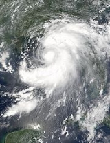
.jpg) Tropical Storm Allison
Tropical Storm Allison
developed from a tropical wave
in the northern Gulf of Mexico
on June 4, 2001, and struck the northern Texas
coast shortly thereafter. It drifted northward through the state, turned to the south, and re-entered the Gulf of Mexico. The storm continued towards the east-northeast, made landfall on Louisiana
and then moved across the southeast United States and Mid-Atlantic
. Allison was the first storm since Tropical Storm Frances
in 1998 to affect the northern Texas coastline.
A tropical depression formed from a low level circulation on July 11, well to the east of the Windward Islands
. It attained a maximum strength of 30 mph (45 km/h), with a pressure of 1010 mbar, though vertical wind shear
from a subtropical ridge
to the north caused it to dissipate on July 12.
On July 24, a tropical wave
moved off the coast of Africa and tracked westward. The wave entered the Caribbean
on July 29 and gained in organization and convection
, and organized into Tropical Storm Barry
on August 3. After fluctuations in intensity, the system attained peak winds of 70 mph (110 km/h) in the Gulf of Mexico
, and headed northward before moving ashore along the Gulf Coast.
Tropical Storm Chantal
developed from a tropical wave on August 14 in the tropical Atlantic Ocean. It tracked rapidly westward for much of its duration, and after degenerating into a tropical wave it passed through the Windward Islands
. Chantal reformed and reached a peak intensity of 70 mph (110 km/h) twice in the Caribbean Sea, and each time, wind shear and later land interaction prevented strengthening to hurricane status. On August 21 Chantal moved ashore near the border of Mexico and Belize, and it dissipated the next day.
A tropical wave spawned Tropical Storm Dean
on August 22 over the Lesser Antilles
. Strong wind shear
quickly weakened Dean to cause it to dissipate on August 23. The remnants turned northward, and redeveloped on August 26 to the north of Bermuda
. Located over warm waters and in an area of favorable conditions, Dean steadily strengthened while moving to the northeast, and peaked just below hurricane status on August 27 southwest of Newfoundland. The storm subsequently weakened over cooler waters, and became extratropical on August 28.
developed from a tropical wave on September 1, and strengthened to a 60 mph (95 km/h) tropical storm as it moved to the west-northwest. After weakening due to wind shear, the remnants re-organized into a tropical depression the next day, and Erin strengthened into a hurricane on September 9 while moving northwestward. The hurricane quickly intensified and reached peak winds of 120 mph (195 km/h) later on September 9. A trough
turned Erin to the northeast, and after passing just east of Cape Race
, Newfoundland
it became extratropical on September 15. The extratropical remnant continued northeastward and lost its identity near Greenland
on September 17.
 A tropical wave off the coast of Africa organized into Tropical Depression Seven on September 7 while near the Cape Verde
islands. It moved rapidly to the west, and degenerated to a tropical wave the next day. By September 10, the wave had reorganized, and it was again named Tropical Depression Seven. The depression continued to strengthen, and became Hurricane Felix by September 13. Tracking roughly northward, Felix intensified rapidly, reaching Category 3 status, and subsequently turned to the north as it began to weaken. By September 17, Felix had dropped to tropical storm strength, and it dissipated two days later.
Hurricane Gabrielle
originated in a weak low- to mid-level trough
that was nearly stationary a short distance off the southeastern coastline of the United States. A cut off low formed over Florida on September 9, and an associated surface low pressure system formed, that was soon designated Tropical Depression Eight. The storm gradually intensified, and made landfall on Florida before emerging into the Atlantic Ocean and accelerating northeastward, as it reached peak intensity as a minimal hurricane.
A tropical depression
formed from a tropical wave in the Caribbean on September 19, north-northwest of San Andres Island. It attained a maximum strength of 35 mi/h, and made landfall near Puerto Cabezas
on September 20. After losing its closed circulation over land, it reformed into Hurricane Juliette
in the East Pacific.
Hurricane Humberto
formed from an area of low pressure generated by Hurricane Gabrielle. The low formed into a tropical depression on September 21 while south of Bermuda
, tracking northwest, and was named Tropical Storm Humberto the next day. It began moving north, and then northeast as it passed Bermuda and strengthened into a hurricane. Humberto headed over the colder waters of the far north Atlantic Ocean, and dissipated quickly on September 27.
Tropical Depression Eleven formed just southeast of Barbados on October 4. It traveled across the Windward Islands, and was named Tropical Storm Iris
while south of Puerto Rico
on October 5. Iris continued to the west and intensified. After passing just south of Jamaica, Iris reached Category 4 hurricane strength, and made landfall near Monkey River Town
, Belize
on October 9 at Category 4 strength, but weakened rapidly. It dissipated later that day.
formed as a tropical depression
from a tropical wave
on October 6 near Barbados
. The storm intensified into a tropical storm early the following day on October 7 while initially located under an environment of weak vertical wind shear
. After reaching its peak of 50 mph (80 km/h), Jerry passed just south of Barbados
late on October 7 and through the Windward Islands on October 8. Deterioration in organization occurred, and Jerry dissipated while moving rapidly westward well south of Puerto Rico
.
A cold front and an upper level trough
interacted on October 10 to the south of Bermuda, and formed an extratropical storm. The storm passed near Bermuda on October 12, producing hurricane-force winds on the island. It then organized, becoming a subtropical cyclone
on October 12 and a tropical cyclone
on October 13. Karen strengthened to reach 80 mph (130 km/h) winds as a Category 1 hurricane on the Saffir–Simpson Hurricane Scale, and after weakening over cooler waters, it made landfall on Nova Scotia
as a tropical storm. It quickly became extratropical.
An upper-level tropospheric trough
persisted in the eastern Atlantic Ocean, developing a low-level circulation by October 26 which quickly gained organization. On October 27, the low developed into Tropical Depression Fourteen about 860 mi (1380 km) south-southwest of the western Azores
, and on October 30 it was upgraded to Tropical Storm Lorenzo. By early on October 31 Lorenzo became extratropical
and merged with a frontal system.
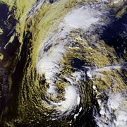 Hurricane Michelle
developed from a tropical wave that moved across the Atlantic, and formed into a tropical depression on October 29. Convection increased, and the system formed into Tropical Storm Michelle on November 1. It strengthened further, reaching its peak strength as a Category 4. One of only four November Category 4 hurricanes, Michelle made landfall on south-central Cuba
with winds of 140 mph (225 km/h), the strongest Cuban landfall since Hurricane Fox
in the 1952 Atlantic hurricane season
.
Hurricane Noel
developed as a subtropical cyclone
from a frontal low
on November 4 to the west of the Azores
. It moved northward, and following an increase in deep convection it transitioned in Hurricane Noel on November 5. Noel quickly weakened as it entered an area of cooler waters and higher wind shear
, and it became an extratropical cyclone
on November 6 to the southeast of Newfoundland. The extratropical remnant of Noel was absorbed by a larger extratropical storm which absorbed the remnants of Hurricane Michelle
, and intensified as it moved westward into Atlantic Canada
, reaching pressures as low as 946 mbar
.
Hurricane Olga
formed as a subtropical cyclone
on November 24 and meandered westward where it reached hurricane status on November 26. The storm attained peak winds of 90 mph (150 km/h) before turning southeastward and weakening back into a tropical storm. Olga dissipated as a tropical cyclone on December 6 east of the Bahamas.
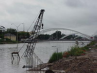 The 2001 season was severe in terms of damages. The most noteworthy storms include Tropical Storm Allison, Hurricane Iris, and Hurricane Michelle. The United States was directly affected by three tropical cyclones, the first of which was Allison. Tropical Storm Allison was a major flood disaster throughout its path from Texas
to the Mid-Atlantic. The worst of the flooding occurred in Houston, Texas
, where over 35 in (890 mm) of rain fell. The storm killed 41 people, of which 27 drowned. The storm also caused over $5 billion in damage (2001 USD; $ USD), making it the deadliest and costliest tropical storm on record in the United States. Allison destroyed 2,744 homes, leaving 30,000 homeless with residential damages totaling to $1.76 billion (2001 USD; $ USD). Tropical Storm Barry affected Florida; rainfall peaked at 8.9 in (226.1 mm) at Tallahassee
, and winds gusts topped out at 79 mph (127.1 km/h). Three people in Florida were killed by the storm, and total damage is estimated at around $30 million (2001 USD; $ USD). Later, Hurricane Gabrielle produced moderate winds along coastal areas of western Florida
, reaching 58 mph (93.3 km/h) at Venice
. The tide flooded the northern shoreline of Charlotte Harbor
and at the entrance to the Peace River
, while further to the south a surge of greater than 3 ft (0.9144 m) inundated the barrier island
at Fort Myers Beach
and flooded some cars.
Canada was also affected by several storms. In August, Tropical Storm Dean lightly affected Newfoundland, though no damages were reported. Hurricane Erin brushed the same area, producing a sustained wind of 53 mph (85 km/h) with a gust of 67 mph (108 km/h) at Cape Race
. Along the coast, the passage of the storm led to wave heights of up to 30 ft (9.3 m). Less than a week later, Hurricane Gabrielle brushed the eastern coast; the rainfall set the all time six hour precipitation record at St. John's
, with a total of 3.54 in (89.9 mm). Hundreds of homes and buildings were damaged by the passage of Gabrielle, totaling several million dollars in damage. Tropical Storm Karen produced light to moderate winds across Atlantic Canada
, peaking at 47 mph (76 km/h) with a gust of 64 mph (103 km/h) in Cape George
in Antigonish County, Nova Scotia
, along with a 26 mph (42 km/h) report in Charlottetown, Prince Edward Island. Later, in Newfoundland
and Nova Scotia
, the storm system that absorbed Hurricane Noel produced strong winds that downed several trees and power lines which resulted in power outages.
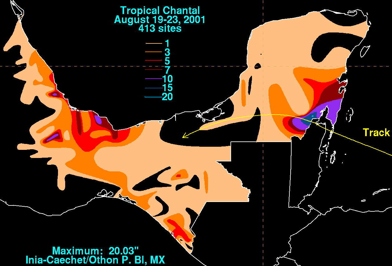 Mexico and Belize
were impacted by a number of storms, starting with Tropical Storm Chantal, which produced a wind gust of 71 mph (115 km/h) in Caye Caulker
, although stronger winds were possible in a convective band to the north. On the Yucatan Peninsula
, heavy rainfall led to mudslides across Quintana Roo
, leaving some areas isolated. Hurricane Iris hit Belize hard, with an 8 to 15 ft (2.4 to 4.6 m) storm surge
. Numerous homes were destroyed, and the banana crop suffered extensive damage. An exact death toll is unknown, but 31 are confirmed dead, three in the Dominican Republic
, eight in Guatemala
, and 20 from the M/V Wave Dancer, a ship that capsized off the Belize coast. What eventually became Hurricane Michelle dropped torrential rains in several countries, causing six deaths in Honduras and four deaths in Nicaragua, with an extensive yet unknown amount of damage. An additional 26 people were reported missing in Central America. Michelle went on to affect Cuba
, where the storm produced 4 to 5 ft (1.2 to 1.5 m) waves, along with a heavy storm surge. Rainfall amounts up to 29.69 in (754 mm) were recorded across the island.
. This is the same list used for the 1995 season
except for Lorenzo, Michelle, Olga, and Rebekah, which replaced Luis
, Marilyn
, Opal
, and Roxanne
. Storms were named Lorenzo, Michelle, and Olga for the first time in 2001. Names that were allocated for the 2001 season but were not assigned are marked in .
retired three names in the spring of 2002: Allison, Iris, and Michelle. They were replaced in the 2007 season
by Andrea
, Ingrid, and Melissa. Allison became the first Atlantic tropical storm to have its name retired.
Atlantic hurricane season
The Atlantic hurricane season is the period in a year when hurricanes usually form in the Atlantic Ocean. Tropical cyclones in the North Atlantic are called hurricanes, tropical storms, or tropical depressions. In addition, there have been several storms over the years that have not been fully...
that produced 17 tropical cyclones, 15 named storms, nine hurricanes, and four major hurricanes. The season officially lasted from June 1, 2001, to November 30, 2001, dates which by convention limit the period of each year when tropical cyclones tend to form in the Atlantic Ocean basin. The season began with Tropical Storm Allison
Tropical Storm Allison
Tropical Storm Allison was a tropical storm that devastated southeast Texas in June of the 2001 Atlantic hurricane season. The first storm of the season, Allison lasted an unusually long period of time for a June storm, remaining tropical or subtropical for 15 days...
on June 4, and ended with Hurricane Olga, which dissipated on December 6. The most intense storm was Hurricane Michelle
Hurricane Michelle
Hurricane Michelle was the thirteenth named storm and the strongest tropical cyclone of the 2001 Atlantic hurricane season. Michelle developed from a tropical wave that moved across the Atlantic, and formed into Tropical Depression Fifteen on the October 29. The depression slowly intensified as...
, which attained Category 4 strength on the Saffir–Simpson Hurricane Scale.
The most damaging storms of the season were Tropical Storm Allison, which caused extensive flooding in Texas
Texas
Texas is the second largest U.S. state by both area and population, and the largest state by area in the contiguous United States.The name, based on the Caddo word "Tejas" meaning "friends" or "allies", was applied by the Spanish to the Caddo themselves and to the region of their settlement in...
, Hurricane Iris
Hurricane Iris
Hurricane Iris was a Category 4 hurricane that devastated Belize in October 2001. It was the eleventh tropical cyclone, ninth named storm, fifth hurricane, and third major hurricane of the 2001 Atlantic hurricane season. It was the second strongest storm of the season behind Hurricane...
which struck Belize
Belize
Belize is a constitutional monarchy and the northernmost country in Central America. Belize has a diverse society, comprising many cultures and languages. Even though Kriol and Spanish are spoken among the population, Belize is the only country in Central America where English is the official...
, and Hurricane Michelle
Hurricane Michelle
Hurricane Michelle was the thirteenth named storm and the strongest tropical cyclone of the 2001 Atlantic hurricane season. Michelle developed from a tropical wave that moved across the Atlantic, and formed into Tropical Depression Fifteen on the October 29. The depression slowly intensified as...
, which affected several countries. Three tropical cyclones made landfall on the United States, three directly affected Canada, and three directly affected Mexico and Central America. Overall, the season caused 105 fatalities, and $7.1 billion (2001 USD; $ USD) in damage. Due to their severe damage, the names Allison, Iris, and Michelle were retired by the World Meteorological Organization
World Meteorological Organization
The World Meteorological Organization is an intergovernmental organization with a membership of 189 Member States and Territories. It originated from the International Meteorological Organization , which was founded in 1873...
.
Season activity
The season's activity was reflected with a accumulated cyclone energyAccumulated cyclone energy
Accumulated cyclone energy is a measure used by the National Oceanic and Atmospheric Administration to express the activity of individual tropical cyclones and entire tropical cyclone seasons, particularly the North Atlantic hurricane season. It uses an approximation of the energy used by a...
(ACE) rating of 110. ACE is, broadly speaking, a measure of the power of the hurricane multiplied by the length of time it existed, so storms that last a long time, as well as particularly strong hurricanes, have high ACEs. ACE is only calculated for full advisories on tropical systems at or exceeding 34 knots (39 mph, 63 km/h) or tropical storm strength. Subtropical cyclone
Subtropical cyclone
A subtropical cyclone is a weather system that has some characteristics of a tropical and an extratropical cyclone. As early as the 1950s, meteorologists were unclear whether they should be characterized as tropical or extratropical cyclones. They were officially recognized by the National...
s, including the latter portion of Allison and the initial portions of Karen, Noel, and Olga, are excluded from the total.
June–August
Tropical Storm Allison
Tropical Storm Allison was a tropical storm that devastated southeast Texas in June of the 2001 Atlantic hurricane season. The first storm of the season, Allison lasted an unusually long period of time for a June storm, remaining tropical or subtropical for 15 days...
developed from a tropical wave
Tropical wave
Tropical waves, easterly waves, or tropical easterly waves, also known as African easterly waves in the Atlantic region, are a type of atmospheric trough, an elongated area of relatively low air pressure, oriented north to south, which move from east to west across the tropics causing areas of...
in the northern Gulf of Mexico
Gulf of Mexico
The Gulf of Mexico is a partially landlocked ocean basin largely surrounded by the North American continent and the island of Cuba. It is bounded on the northeast, north and northwest by the Gulf Coast of the United States, on the southwest and south by Mexico, and on the southeast by Cuba. In...
on June 4, 2001, and struck the northern Texas
Texas
Texas is the second largest U.S. state by both area and population, and the largest state by area in the contiguous United States.The name, based on the Caddo word "Tejas" meaning "friends" or "allies", was applied by the Spanish to the Caddo themselves and to the region of their settlement in...
coast shortly thereafter. It drifted northward through the state, turned to the south, and re-entered the Gulf of Mexico. The storm continued towards the east-northeast, made landfall on Louisiana
Louisiana
Louisiana is a state located in the southern region of the United States of America. Its capital is Baton Rouge and largest city is New Orleans. Louisiana is the only state in the U.S. with political subdivisions termed parishes, which are local governments equivalent to counties...
and then moved across the southeast United States and Mid-Atlantic
Mid-Atlantic States
The Mid-Atlantic states, also called middle Atlantic states or simply the mid Atlantic, form a region of the United States generally located between New England and the South...
. Allison was the first storm since Tropical Storm Frances
Tropical Storm Frances (1998)
Originating over the southwest Caribbean sea on September 4, Tropical Storm Frances became the sixth tropical storm of the 1998 Atlantic hurricane season. The cyclone moved northward through the western Gulf of Mexico, making landfall across the central Texas coastline before recurving across the...
in 1998 to affect the northern Texas coastline.
A tropical depression formed from a low level circulation on July 11, well to the east of the Windward Islands
Windward Islands
The Windward Islands are the southern islands of the Lesser Antilles, within the West Indies.-Name and geography:The Windward Islands are called such because they were more windward to sailing ships arriving in the New World than the Leeward Islands, given that the prevailing trade winds in the...
. It attained a maximum strength of 30 mph (45 km/h), with a pressure of 1010 mbar, though vertical wind shear
Wind shear
Wind shear, sometimes referred to as windshear or wind gradient, is a difference in wind speed and direction over a relatively short distance in the atmosphere...
from a subtropical ridge
High pressure area
A high-pressure area is a region where the atmospheric pressure at the surface of the planet is greater than its surrounding environment. Winds within high-pressure areas flow outward due to the higher density air near their center and friction with land...
to the north caused it to dissipate on July 12.
On July 24, a tropical wave
Tropical wave
Tropical waves, easterly waves, or tropical easterly waves, also known as African easterly waves in the Atlantic region, are a type of atmospheric trough, an elongated area of relatively low air pressure, oriented north to south, which move from east to west across the tropics causing areas of...
moved off the coast of Africa and tracked westward. The wave entered the Caribbean
Caribbean
The Caribbean is a crescent-shaped group of islands more than 2,000 miles long separating the Gulf of Mexico and the Caribbean Sea, to the west and south, from the Atlantic Ocean, to the east and north...
on July 29 and gained in organization and convection
Atmospheric convection
Atmospheric convection is the result of a parcel-environment instability, or temperature difference, layer in the atmosphere. Different lapse rates within dry and moist air lead to instability. Mixing of air during the day which expands the height of the planetary boundary layer leads to...
, and organized into Tropical Storm Barry
Tropical Storm Barry (2001)
Tropical Storm Barry was a strong tropical storm that made landfall on the Florida Panhandle during August 2001. The third tropical cyclone and second named storm of the 2001 Atlantic hurricane season, Barry developed from a tropical wave that moved off the coast of Africa on July 24 and tracked...
on August 3. After fluctuations in intensity, the system attained peak winds of 70 mph (110 km/h) in the Gulf of Mexico
Gulf of Mexico
The Gulf of Mexico is a partially landlocked ocean basin largely surrounded by the North American continent and the island of Cuba. It is bounded on the northeast, north and northwest by the Gulf Coast of the United States, on the southwest and south by Mexico, and on the southeast by Cuba. In...
, and headed northward before moving ashore along the Gulf Coast.
Tropical Storm Chantal
Tropical Storm Chantal (2001)
Tropical Storm Chantal was an Atlantic tropical cyclone that moved across the Caribbean Sea in August 2001. Chantal developed from a tropical wave on August 14 in the tropical Atlantic Ocean. It tracked rapidly westward for much of its duration, and after degenerating into a tropical wave...
developed from a tropical wave on August 14 in the tropical Atlantic Ocean. It tracked rapidly westward for much of its duration, and after degenerating into a tropical wave it passed through the Windward Islands
Windward Islands
The Windward Islands are the southern islands of the Lesser Antilles, within the West Indies.-Name and geography:The Windward Islands are called such because they were more windward to sailing ships arriving in the New World than the Leeward Islands, given that the prevailing trade winds in the...
. Chantal reformed and reached a peak intensity of 70 mph (110 km/h) twice in the Caribbean Sea, and each time, wind shear and later land interaction prevented strengthening to hurricane status. On August 21 Chantal moved ashore near the border of Mexico and Belize, and it dissipated the next day.
A tropical wave spawned Tropical Storm Dean
Tropical Storm Dean (2001)
Tropical Storm Dean was a strong tropical storm that affected at least twelve islands along its path from the tropical Atlantic Ocean to east of Atlantic Canada. Dean developed from a tropical wave on August 22 over the Lesser Antilles, and was initially predicted to intensify further to reach...
on August 22 over the Lesser Antilles
Lesser Antilles
The Lesser Antilles are a long, partly volcanic island arc in the Western Hemisphere. Most of its islands form the eastern boundary of the Caribbean Sea with the Atlantic Ocean, with the remainder located in the southern Caribbean just north of South America...
. Strong wind shear
Wind shear
Wind shear, sometimes referred to as windshear or wind gradient, is a difference in wind speed and direction over a relatively short distance in the atmosphere...
quickly weakened Dean to cause it to dissipate on August 23. The remnants turned northward, and redeveloped on August 26 to the north of Bermuda
Bermuda
Bermuda is a British overseas territory in the North Atlantic Ocean. Located off the east coast of the United States, its nearest landmass is Cape Hatteras, North Carolina, about to the west-northwest. It is about south of Halifax, Nova Scotia, Canada, and northeast of Miami, Florida...
. Located over warm waters and in an area of favorable conditions, Dean steadily strengthened while moving to the northeast, and peaked just below hurricane status on August 27 southwest of Newfoundland. The storm subsequently weakened over cooler waters, and became extratropical on August 28.
September
Hurricane ErinHurricane Erin (2001)
Hurricane Erin was the longest-lived hurricane in the 2001 Atlantic hurricane season. The sixth tropical depression, fifth tropical storm, and first hurricane, Erin developed from a tropical wave on September 1. After strengthening to a 60 mph tropical storm as it moved to the west-northwest,...
developed from a tropical wave on September 1, and strengthened to a 60 mph (95 km/h) tropical storm as it moved to the west-northwest. After weakening due to wind shear, the remnants re-organized into a tropical depression the next day, and Erin strengthened into a hurricane on September 9 while moving northwestward. The hurricane quickly intensified and reached peak winds of 120 mph (195 km/h) later on September 9. A trough
Trough (meteorology)
A trough is an elongated region of relatively low atmospheric pressure, often associated with fronts.Unlike fronts, there is not a universal symbol for a trough on a weather chart. The weather charts in some countries or regions mark troughs by a line. In the United States, a trough may be marked...
turned Erin to the northeast, and after passing just east of Cape Race
Cape Race
Cape Race is a point of land located at the southeastern tip of the Avalon Peninsula on the island of Newfoundland, Canada. Its name is thought to come from the original Portuguese name for this cape, "Raso", or "bare"...
, Newfoundland
Newfoundland and Labrador
Newfoundland and Labrador is the easternmost province of Canada. Situated in the country's Atlantic region, it incorporates the island of Newfoundland and mainland Labrador with a combined area of . As of April 2011, the province's estimated population is 508,400...
it became extratropical on September 15. The extratropical remnant continued northeastward and lost its identity near Greenland
Greenland
Greenland is an autonomous country within the Kingdom of Denmark, located between the Arctic and Atlantic Oceans, east of the Canadian Arctic Archipelago. Though physiographically a part of the continent of North America, Greenland has been politically and culturally associated with Europe for...
on September 17.
Cape Verde
The Republic of Cape Verde is an island country, spanning an archipelago of 10 islands located in the central Atlantic Ocean, 570 kilometres off the coast of Western Africa...
islands. It moved rapidly to the west, and degenerated to a tropical wave the next day. By September 10, the wave had reorganized, and it was again named Tropical Depression Seven. The depression continued to strengthen, and became Hurricane Felix by September 13. Tracking roughly northward, Felix intensified rapidly, reaching Category 3 status, and subsequently turned to the north as it began to weaken. By September 17, Felix had dropped to tropical storm strength, and it dissipated two days later.
Hurricane Gabrielle
Hurricane Gabrielle (2001)
Hurricane Gabrielle was a moderate category 1 hurricane which made landfall near Venice, Florida as a strong tropical storm. The eighth tropical cyclone, seventh named storm, and third hurricane of the 2001 Atlantic hurricane season, Gabrielle developed from a non-tropical low-to mid-level trough...
originated in a weak low- to mid-level trough
Trough (meteorology)
A trough is an elongated region of relatively low atmospheric pressure, often associated with fronts.Unlike fronts, there is not a universal symbol for a trough on a weather chart. The weather charts in some countries or regions mark troughs by a line. In the United States, a trough may be marked...
that was nearly stationary a short distance off the southeastern coastline of the United States. A cut off low formed over Florida on September 9, and an associated surface low pressure system formed, that was soon designated Tropical Depression Eight. The storm gradually intensified, and made landfall on Florida before emerging into the Atlantic Ocean and accelerating northeastward, as it reached peak intensity as a minimal hurricane.
A tropical depression
Tropical Depression Nine (2001)
Tropical Depression Nine was the ninth tropical depression of the 2001 Atlantic hurricane season. It formed off the Nicaraguan coast on September 19 and made landfall three hours later. The system quickly dissipated the next morning causing no reports of damage or deaths...
formed from a tropical wave in the Caribbean on September 19, north-northwest of San Andres Island. It attained a maximum strength of 35 mi/h, and made landfall near Puerto Cabezas
Puerto Cabezas
Puerto Cabezas is a municipality in, and capital of, the North Atlantic Coast department of Nicaragua....
on September 20. After losing its closed circulation over land, it reformed into Hurricane Juliette
Hurricane Juliette (2001)
Hurricane Juliette was a long lasting Category 4 hurricane in the 2001 Pacific hurricane season. It caused 12 deaths and $400 million in damage when it hit Baja California in late September.-Meteorological history:...
in the East Pacific.
Hurricane Humberto
Hurricane Humberto (2001)
Hurricane Humberto was a moderately powerful hurricane that briefly affected Bermuda in September 2001. It was the eighth named storm of the season, as well as the fourth hurricane. It formed on September 21 between Puerto Rico and Bermuda, partially related to previous Hurricane Gabrielle...
formed from an area of low pressure generated by Hurricane Gabrielle. The low formed into a tropical depression on September 21 while south of Bermuda
Bermuda
Bermuda is a British overseas territory in the North Atlantic Ocean. Located off the east coast of the United States, its nearest landmass is Cape Hatteras, North Carolina, about to the west-northwest. It is about south of Halifax, Nova Scotia, Canada, and northeast of Miami, Florida...
, tracking northwest, and was named Tropical Storm Humberto the next day. It began moving north, and then northeast as it passed Bermuda and strengthened into a hurricane. Humberto headed over the colder waters of the far north Atlantic Ocean, and dissipated quickly on September 27.
Tropical Depression Eleven formed just southeast of Barbados on October 4. It traveled across the Windward Islands, and was named Tropical Storm Iris
Hurricane Iris
Hurricane Iris was a Category 4 hurricane that devastated Belize in October 2001. It was the eleventh tropical cyclone, ninth named storm, fifth hurricane, and third major hurricane of the 2001 Atlantic hurricane season. It was the second strongest storm of the season behind Hurricane...
while south of Puerto Rico
Puerto Rico
Puerto Rico , officially the Commonwealth of Puerto Rico , is an unincorporated territory of the United States, located in the northeastern Caribbean, east of the Dominican Republic and west of both the United States Virgin Islands and the British Virgin Islands.Puerto Rico comprises an...
on October 5. Iris continued to the west and intensified. After passing just south of Jamaica, Iris reached Category 4 hurricane strength, and made landfall near Monkey River Town
Monkey River Town
Monkey River Town is a village in the north of the Toledo District of the Central American nation of Belize. It is on the Caribbean Sea on the southern shore of the mouth of Belize's Monkey River...
, Belize
Belize
Belize is a constitutional monarchy and the northernmost country in Central America. Belize has a diverse society, comprising many cultures and languages. Even though Kriol and Spanish are spoken among the population, Belize is the only country in Central America where English is the official...
on October 9 at Category 4 strength, but weakened rapidly. It dissipated later that day.
October and November
Tropical Storm JerryTropical Storm Jerry (2001)
Tropical Storm Jerry was a short-lived tropical storm that formed in the latter half of the 2001 Atlantic hurricane season. Forming as a tropical depression from a tropical wave on October 6 near Barbados, Jerry intensified into a tropical storm early the following day on October 7 while initially...
formed as a tropical depression
Tropical cyclone
A tropical cyclone is a storm system characterized by a large low-pressure center and numerous thunderstorms that produce strong winds and heavy rain. Tropical cyclones strengthen when water evaporated from the ocean is released as the saturated air rises, resulting in condensation of water vapor...
from a tropical wave
Tropical wave
Tropical waves, easterly waves, or tropical easterly waves, also known as African easterly waves in the Atlantic region, are a type of atmospheric trough, an elongated area of relatively low air pressure, oriented north to south, which move from east to west across the tropics causing areas of...
on October 6 near Barbados
Barbados
Barbados is an island country in the Lesser Antilles. It is in length and as much as in width, amounting to . It is situated in the western area of the North Atlantic and 100 kilometres east of the Windward Islands and the Caribbean Sea; therein, it is about east of the islands of Saint...
. The storm intensified into a tropical storm early the following day on October 7 while initially located under an environment of weak vertical wind shear
Wind shear
Wind shear, sometimes referred to as windshear or wind gradient, is a difference in wind speed and direction over a relatively short distance in the atmosphere...
. After reaching its peak of 50 mph (80 km/h), Jerry passed just south of Barbados
Barbados
Barbados is an island country in the Lesser Antilles. It is in length and as much as in width, amounting to . It is situated in the western area of the North Atlantic and 100 kilometres east of the Windward Islands and the Caribbean Sea; therein, it is about east of the islands of Saint...
late on October 7 and through the Windward Islands on October 8. Deterioration in organization occurred, and Jerry dissipated while moving rapidly westward well south of Puerto Rico
Puerto Rico
Puerto Rico , officially the Commonwealth of Puerto Rico , is an unincorporated territory of the United States, located in the northeastern Caribbean, east of the Dominican Republic and west of both the United States Virgin Islands and the British Virgin Islands.Puerto Rico comprises an...
.
A cold front and an upper level trough
Trough (meteorology)
A trough is an elongated region of relatively low atmospheric pressure, often associated with fronts.Unlike fronts, there is not a universal symbol for a trough on a weather chart. The weather charts in some countries or regions mark troughs by a line. In the United States, a trough may be marked...
interacted on October 10 to the south of Bermuda, and formed an extratropical storm. The storm passed near Bermuda on October 12, producing hurricane-force winds on the island. It then organized, becoming a subtropical cyclone
Subtropical cyclone
A subtropical cyclone is a weather system that has some characteristics of a tropical and an extratropical cyclone. As early as the 1950s, meteorologists were unclear whether they should be characterized as tropical or extratropical cyclones. They were officially recognized by the National...
on October 12 and a tropical cyclone
Tropical cyclone
A tropical cyclone is a storm system characterized by a large low-pressure center and numerous thunderstorms that produce strong winds and heavy rain. Tropical cyclones strengthen when water evaporated from the ocean is released as the saturated air rises, resulting in condensation of water vapor...
on October 13. Karen strengthened to reach 80 mph (130 km/h) winds as a Category 1 hurricane on the Saffir–Simpson Hurricane Scale, and after weakening over cooler waters, it made landfall on Nova Scotia
Nova Scotia
Nova Scotia is one of Canada's three Maritime provinces and is the most populous province in Atlantic Canada. The name of the province is Latin for "New Scotland," but "Nova Scotia" is the recognized, English-language name of the province. The provincial capital is Halifax. Nova Scotia is the...
as a tropical storm. It quickly became extratropical.
An upper-level tropospheric trough
Trough (meteorology)
A trough is an elongated region of relatively low atmospheric pressure, often associated with fronts.Unlike fronts, there is not a universal symbol for a trough on a weather chart. The weather charts in some countries or regions mark troughs by a line. In the United States, a trough may be marked...
persisted in the eastern Atlantic Ocean, developing a low-level circulation by October 26 which quickly gained organization. On October 27, the low developed into Tropical Depression Fourteen about 860 mi (1380 km) south-southwest of the western Azores
Azores
The Archipelago of the Azores is composed of nine volcanic islands situated in the middle of the North Atlantic Ocean, and is located about west from Lisbon and about east from the east coast of North America. The islands, and their economic exclusion zone, form the Autonomous Region of the...
, and on October 30 it was upgraded to Tropical Storm Lorenzo. By early on October 31 Lorenzo became extratropical
Extratropical cyclone
Extratropical cyclones, sometimes called mid-latitude cyclones or wave cyclones, are a group of cyclones defined as synoptic scale low pressure weather systems that occur in the middle latitudes of the Earth having neither tropical nor polar characteristics, and are connected with fronts and...
and merged with a frontal system.
Hurricane Michelle
Hurricane Michelle was the thirteenth named storm and the strongest tropical cyclone of the 2001 Atlantic hurricane season. Michelle developed from a tropical wave that moved across the Atlantic, and formed into Tropical Depression Fifteen on the October 29. The depression slowly intensified as...
developed from a tropical wave that moved across the Atlantic, and formed into a tropical depression on October 29. Convection increased, and the system formed into Tropical Storm Michelle on November 1. It strengthened further, reaching its peak strength as a Category 4. One of only four November Category 4 hurricanes, Michelle made landfall on south-central Cuba
Cuba
The Republic of Cuba is an island nation in the Caribbean. The nation of Cuba consists of the main island of Cuba, the Isla de la Juventud, and several archipelagos. Havana is the largest city in Cuba and the country's capital. Santiago de Cuba is the second largest city...
with winds of 140 mph (225 km/h), the strongest Cuban landfall since Hurricane Fox
Hurricane Fox (1952)
Hurricane Fox was the strongest and deadliest tropical cyclone of the below average 1952 Atlantic hurricane season. The seventh tropical storm, sixth Atlantic hurricane, and the third major hurricane of the season, Fox was a small and intense Caribbean storm that developed northwest of Cartagena,...
in the 1952 Atlantic hurricane season
1952 Atlantic hurricane season
The 1952 Atlantic hurricane season was the most recent season in which all named storms attained hurricane status, although it was the least active since 1946. The season officially started on June 15; however, a pre-season unnamed storm formed on Groundhog Day, becoming the only storm on...
.
Hurricane Noel
Hurricane Noel (2001)
The November 2001 Atlantic Canada storm complex was a powerful coastal storm that included the remnants of Atlantic hurricanes Michelle and Noel. The low intensified as it moved westward into Atlantic Canada on November 6, reaching pressures as low as 946 mbar. The storm turned to the...
developed as a subtropical cyclone
Subtropical cyclone
A subtropical cyclone is a weather system that has some characteristics of a tropical and an extratropical cyclone. As early as the 1950s, meteorologists were unclear whether they should be characterized as tropical or extratropical cyclones. They were officially recognized by the National...
from a frontal low
Surface weather analysis
Surface weather analysis is a special type of weather map that provides a view of weather elements over a geographical area at a specified time based on information from ground-based weather stations...
on November 4 to the west of the Azores
Azores
The Archipelago of the Azores is composed of nine volcanic islands situated in the middle of the North Atlantic Ocean, and is located about west from Lisbon and about east from the east coast of North America. The islands, and their economic exclusion zone, form the Autonomous Region of the...
. It moved northward, and following an increase in deep convection it transitioned in Hurricane Noel on November 5. Noel quickly weakened as it entered an area of cooler waters and higher wind shear
Wind shear
Wind shear, sometimes referred to as windshear or wind gradient, is a difference in wind speed and direction over a relatively short distance in the atmosphere...
, and it became an extratropical cyclone
Extratropical cyclone
Extratropical cyclones, sometimes called mid-latitude cyclones or wave cyclones, are a group of cyclones defined as synoptic scale low pressure weather systems that occur in the middle latitudes of the Earth having neither tropical nor polar characteristics, and are connected with fronts and...
on November 6 to the southeast of Newfoundland. The extratropical remnant of Noel was absorbed by a larger extratropical storm which absorbed the remnants of Hurricane Michelle
Hurricane Michelle
Hurricane Michelle was the thirteenth named storm and the strongest tropical cyclone of the 2001 Atlantic hurricane season. Michelle developed from a tropical wave that moved across the Atlantic, and formed into Tropical Depression Fifteen on the October 29. The depression slowly intensified as...
, and intensified as it moved westward into Atlantic Canada
Atlantic Canada
Atlantic Canada is the region of Canada comprising the four provinces located on the Atlantic coast, excluding Quebec: the three Maritime provinces – New Brunswick, Prince Edward Island, and Nova Scotia – and Newfoundland and Labrador...
, reaching pressures as low as 946 mbar
Bar (unit)
The bar is a unit of pressure equal to 100 kilopascals, and roughly equal to the atmospheric pressure on Earth at sea level. Other units derived from the bar are the megabar , kilobar , decibar , centibar , and millibar...
.
Hurricane Olga
Hurricane Olga (2001)
Hurricane Olga was a late season Category 1 Atlantic hurricane that formed during the 2001 Atlantic hurricane season. The fifteenth named storm, ninth and final hurricane of the 2001 season, Olga formed as a subtropical cyclone on November 24. After acquiring tropical characteristics later that...
formed as a subtropical cyclone
Subtropical cyclone
A subtropical cyclone is a weather system that has some characteristics of a tropical and an extratropical cyclone. As early as the 1950s, meteorologists were unclear whether they should be characterized as tropical or extratropical cyclones. They were officially recognized by the National...
on November 24 and meandered westward where it reached hurricane status on November 26. The storm attained peak winds of 90 mph (150 km/h) before turning southeastward and weakening back into a tropical storm. Olga dissipated as a tropical cyclone on December 6 east of the Bahamas.
Impact
Texas
Texas is the second largest U.S. state by both area and population, and the largest state by area in the contiguous United States.The name, based on the Caddo word "Tejas" meaning "friends" or "allies", was applied by the Spanish to the Caddo themselves and to the region of their settlement in...
to the Mid-Atlantic. The worst of the flooding occurred in Houston, Texas
Houston, Texas
Houston is the fourth-largest city in the United States, and the largest city in the state of Texas. According to the 2010 U.S. Census, the city had a population of 2.1 million people within an area of . Houston is the seat of Harris County and the economic center of , which is the ...
, where over 35 in (890 mm) of rain fell. The storm killed 41 people, of which 27 drowned. The storm also caused over $5 billion in damage (2001 USD; $ USD), making it the deadliest and costliest tropical storm on record in the United States. Allison destroyed 2,744 homes, leaving 30,000 homeless with residential damages totaling to $1.76 billion (2001 USD; $ USD). Tropical Storm Barry affected Florida; rainfall peaked at 8.9 in (226.1 mm) at Tallahassee
Tallahassee, Florida
Tallahassee is the capital of the U.S. state of Florida. It is the county seat and only incorporated municipality in Leon County, and is the 128th largest city in the United States. Tallahassee became the capital of Florida, then the Florida Territory, in 1824. In 2010, the population recorded by...
, and winds gusts topped out at 79 mph (127.1 km/h). Three people in Florida were killed by the storm, and total damage is estimated at around $30 million (2001 USD; $ USD). Later, Hurricane Gabrielle produced moderate winds along coastal areas of western Florida
Florida
Florida is a state in the southeastern United States, located on the nation's Atlantic and Gulf coasts. It is bordered to the west by the Gulf of Mexico, to the north by Alabama and Georgia and to the east by the Atlantic Ocean. With a population of 18,801,310 as measured by the 2010 census, it...
, reaching 58 mph (93.3 km/h) at Venice
Venice, Florida
Venice is a city in Sarasota County, Florida, United States. According to the U.S. Census Bureau's 2007 estimates, the city had a population of 21,015. It is noted for its large snowbird population. Its newspaper is the Venice Gondolier Sun...
. The tide flooded the northern shoreline of Charlotte Harbor
Charlotte Harbor (estuary)
Charlotte Harbor Estuary is a natural estuary spanning the west coast of Florida from Venice to Bonita Springs on the Gulf of Mexico and is one of the most productive wetlands in Florida...
and at the entrance to the Peace River
Peace River (Florida)
The Peace River is a river in the southwestern part of the Florida peninsula, in the U.S.A.. It originates at the juncture of Saddle Creek and Peace Creek northeast of Bartow in Polk County and flows south through Hardee County to Arcadia in DeSoto County and then southwest into the Charlotte...
, while further to the south a surge of greater than 3 ft (0.9144 m) inundated the barrier island
Barrier island
Barrier islands, a coastal landform and a type of barrier system, are relatively narrow strips of sand that parallel the mainland coast. They usually occur in chains, consisting of anything from a few islands to more than a dozen...
at Fort Myers Beach
Fort Myers Beach, Florida
Fort Myers Beach is a town located on Estero Island in Lee County, Florida, United States. The population was 6,561 at the 2000 census. It is part of the Cape Coral–Fort Myers Metropolitan Statistical Area.-Geography:...
and flooded some cars.
Canada was also affected by several storms. In August, Tropical Storm Dean lightly affected Newfoundland, though no damages were reported. Hurricane Erin brushed the same area, producing a sustained wind of 53 mph (85 km/h) with a gust of 67 mph (108 km/h) at Cape Race
Cape Race
Cape Race is a point of land located at the southeastern tip of the Avalon Peninsula on the island of Newfoundland, Canada. Its name is thought to come from the original Portuguese name for this cape, "Raso", or "bare"...
. Along the coast, the passage of the storm led to wave heights of up to 30 ft (9.3 m). Less than a week later, Hurricane Gabrielle brushed the eastern coast; the rainfall set the all time six hour precipitation record at St. John's
St. John's, Newfoundland and Labrador
St. John's is the capital and largest city in Newfoundland and Labrador, and is the oldest English-founded city in North America. It is located on the eastern tip of the Avalon Peninsula on the island of Newfoundland. With a population of 192,326 as of July 1, 2010, the St...
, with a total of 3.54 in (89.9 mm). Hundreds of homes and buildings were damaged by the passage of Gabrielle, totaling several million dollars in damage. Tropical Storm Karen produced light to moderate winds across Atlantic Canada
Atlantic Canada
Atlantic Canada is the region of Canada comprising the four provinces located on the Atlantic coast, excluding Quebec: the three Maritime provinces – New Brunswick, Prince Edward Island, and Nova Scotia – and Newfoundland and Labrador...
, peaking at 47 mph (76 km/h) with a gust of 64 mph (103 km/h) in Cape George
Cape George, Nova Scotia
Cape George is a headland and community of the same name located Antigonish County, Nova Scotia, Canada.It defines the northwestern limit of St. George's Bay....
in Antigonish County, Nova Scotia
Antigonish County, Nova Scotia
Antigonish County, Nova Scotia is a county in the Canadian province of Nova Scotia. It is located in northern Nova Scotia on the Northumberland Strait and its county seat is the town of Antigonish.-History:...
, along with a 26 mph (42 km/h) report in Charlottetown, Prince Edward Island. Later, in Newfoundland
Newfoundland and Labrador
Newfoundland and Labrador is the easternmost province of Canada. Situated in the country's Atlantic region, it incorporates the island of Newfoundland and mainland Labrador with a combined area of . As of April 2011, the province's estimated population is 508,400...
and Nova Scotia
Nova Scotia
Nova Scotia is one of Canada's three Maritime provinces and is the most populous province in Atlantic Canada. The name of the province is Latin for "New Scotland," but "Nova Scotia" is the recognized, English-language name of the province. The provincial capital is Halifax. Nova Scotia is the...
, the storm system that absorbed Hurricane Noel produced strong winds that downed several trees and power lines which resulted in power outages.
Belize
Belize is a constitutional monarchy and the northernmost country in Central America. Belize has a diverse society, comprising many cultures and languages. Even though Kriol and Spanish are spoken among the population, Belize is the only country in Central America where English is the official...
were impacted by a number of storms, starting with Tropical Storm Chantal, which produced a wind gust of 71 mph (115 km/h) in Caye Caulker
Caye Caulker
Caye Caulker is a small limestone coral island off the coast of Belize in the Caribbean Sea measuring about by less than . The town on the island is known by the name Caye Caulker Village...
, although stronger winds were possible in a convective band to the north. On the Yucatan Peninsula
Yucatán Peninsula
The Yucatán Peninsula, in southeastern Mexico, separates the Caribbean Sea from the Gulf of Mexico, with the northern coastline on the Yucatán Channel...
, heavy rainfall led to mudslides across Quintana Roo
Quintana Roo
Quintana Roo officially Estado Libre y Soberano de Quintana Roo is one of the 31 states which, with the Federal District, comprise the 32 Federal Entities of Mexico. It is divided in 10 municipalities and its capital city is Chetumal....
, leaving some areas isolated. Hurricane Iris hit Belize hard, with an 8 to 15 ft (2.4 to 4.6 m) storm surge
Storm surge
A storm surge is an offshore rise of water associated with a low pressure weather system, typically tropical cyclones and strong extratropical cyclones. Storm surges are caused primarily by high winds pushing on the ocean's surface. The wind causes the water to pile up higher than the ordinary sea...
. Numerous homes were destroyed, and the banana crop suffered extensive damage. An exact death toll is unknown, but 31 are confirmed dead, three in the Dominican Republic
Dominican Republic
The Dominican Republic is a nation on the island of La Hispaniola, part of the Greater Antilles archipelago in the Caribbean region. The western third of the island is occupied by the nation of Haiti, making Hispaniola one of two Caribbean islands that are shared by two countries...
, eight in Guatemala
Guatemala
Guatemala is a country in Central America bordered by Mexico to the north and west, the Pacific Ocean to the southwest, Belize to the northeast, the Caribbean to the east, and Honduras and El Salvador to the southeast...
, and 20 from the M/V Wave Dancer, a ship that capsized off the Belize coast. What eventually became Hurricane Michelle dropped torrential rains in several countries, causing six deaths in Honduras and four deaths in Nicaragua, with an extensive yet unknown amount of damage. An additional 26 people were reported missing in Central America. Michelle went on to affect Cuba
Cuba
The Republic of Cuba is an island nation in the Caribbean. The nation of Cuba consists of the main island of Cuba, the Isla de la Juventud, and several archipelagos. Havana is the largest city in Cuba and the country's capital. Santiago de Cuba is the second largest city...
, where the storm produced 4 to 5 ft (1.2 to 1.5 m) waves, along with a heavy storm surge. Rainfall amounts up to 29.69 in (754 mm) were recorded across the island.
Season impact
Storm names
The following names were used for named storms that formed in the north Atlantic in 2001. The names not retired from this list will be used again in the 2007 season2007 Atlantic hurricane season
The 2007 Atlantic hurricane season was an active Atlantic hurricane season that produced 17 tropical cyclones, 15 tropical storms, six hurricanes, and two major hurricanes. It officially started on June 1 and ended on November 30, dates which conventionally delimit the...
. This is the same list used for the 1995 season
1995 Atlantic hurricane season
The 1995 Atlantic hurricane season was the third most active Atlantic hurricane season on record. It officially began on June 1, 1995, and lasted until November 30, 1995. These dates conventionally delimit the period of each year when most tropical cyclones form in the north Atlantic ocean...
except for Lorenzo, Michelle, Olga, and Rebekah, which replaced Luis
Hurricane Luis
Hurricane Luis was one of the deadliest and most destructive hurricanes of the 1995 Atlantic hurricane season, with maximum sustained winds of 140 mph . The storm was the twelfth tropical storm, sixth hurricane, and second major hurricane of the season...
, Marilyn
Hurricane Marilyn
Hurricane Marilyn was the fifteenth tropical depression and thirteenth named storm of the unusually busy 1995 Atlantic hurricane season, following closely on the heels of Hurricane Luis. Hurricane Marilyn was the most powerful storm to hit the Virgin Islands since Hurricane Hugo of 1989.Marilyn...
, Opal
Hurricane Opal
Hurricane Opal was a Category 4 hurricane that formed in the Gulf of Mexico in September 1995.Opal was the ninth hurricane and the strongest of the abnormally active 1995 Atlantic hurricane season...
, and Roxanne
Hurricane Roxanne
Hurricane Roxanne caused extensive flooding in Mexico due to its erratic movement. The seventeenth storm, tenth hurricane, and the fifth and final major hurricane of the very active 1995 Atlantic hurricane season, Roxanne developed in the southwestern Caribbean Sea from an area of low pressure on...
. Storms were named Lorenzo, Michelle, and Olga for the first time in 2001. Names that were allocated for the 2001 season but were not assigned are marked in .
|
Hurricane Humberto (2001) Hurricane Humberto was a moderately powerful hurricane that briefly affected Bermuda in September 2001. It was the eighth named storm of the season, as well as the fourth hurricane. It formed on September 21 between Puerto Rico and Bermuda, partially related to previous Hurricane Gabrielle... Hurricane Iris Hurricane Iris was a Category 4 hurricane that devastated Belize in October 2001. It was the eleventh tropical cyclone, ninth named storm, fifth hurricane, and third major hurricane of the 2001 Atlantic hurricane season. It was the second strongest storm of the season behind Hurricane... Tropical Storm Jerry (2001) Tropical Storm Jerry was a short-lived tropical storm that formed in the latter half of the 2001 Atlantic hurricane season. Forming as a tropical depression from a tropical wave on October 6 near Barbados, Jerry intensified into a tropical storm early the following day on October 7 while initially... Hurricane Karen (2001) Hurricane Karen was a hurricane of non-tropical origin that formed in October of the 2001 Atlantic hurricane season. It developed out of the interaction between a cold front and an upper level trough on October 10 located to the south of Bermuda, and quickly strengthened as an extratropical storm.... Hurricane Michelle Hurricane Michelle was the thirteenth named storm and the strongest tropical cyclone of the 2001 Atlantic hurricane season. Michelle developed from a tropical wave that moved across the Atlantic, and formed into Tropical Depression Fifteen on the October 29. The depression slowly intensified as... Hurricane Noel (2001) The November 2001 Atlantic Canada storm complex was a powerful coastal storm that included the remnants of Atlantic hurricanes Michelle and Noel. The low intensified as it moved westward into Atlantic Canada on November 6, reaching pressures as low as 946 mbar. The storm turned to the... |
Hurricane Olga (2001) Hurricane Olga was a late season Category 1 Atlantic hurricane that formed during the 2001 Atlantic hurricane season. The fifteenth named storm, ninth and final hurricane of the 2001 season, Olga formed as a subtropical cyclone on November 24. After acquiring tropical characteristics later that... |
Retirement
The World Meteorological OrganizationWorld Meteorological Organization
The World Meteorological Organization is an intergovernmental organization with a membership of 189 Member States and Territories. It originated from the International Meteorological Organization , which was founded in 1873...
retired three names in the spring of 2002: Allison, Iris, and Michelle. They were replaced in the 2007 season
2007 Atlantic hurricane season
The 2007 Atlantic hurricane season was an active Atlantic hurricane season that produced 17 tropical cyclones, 15 tropical storms, six hurricanes, and two major hurricanes. It officially started on June 1 and ended on November 30, dates which conventionally delimit the...
by Andrea
Subtropical Storm Andrea (2007)
Subtropical Storm Andrea was the first named storm and first subtropical cyclone of the 2007 Atlantic hurricane season. It developed out of a previously non-tropical low on May 9 about 150 miles northeast of Daytona Beach, Florida, three weeks before the official start of the season...
, Ingrid, and Melissa. Allison became the first Atlantic tropical storm to have its name retired.
See also
- List of Atlantic hurricane seasons
- List of tropical cyclones
- 2001 Pacific hurricane season2001 Pacific hurricane seasonThe 2001 Pacific hurricane season was an event in tropical cyclone meteorology. The most notable storm that year was Hurricane Juliette, which caused devastating floods in Baja California, leading to 12 fatalities and $400 million worth of damage...
- 2001 Pacific typhoon season2001 Pacific typhoon seasonThe 2001 Pacific typhoon season has no official bounds; it ran year-round in 2001, but most tropical cyclones tend to form in the northwestern Pacific Ocean between May and November...
- 2001 North Indian Ocean cyclone season2001 North Indian Ocean cyclone seasonThe 2001 North Indian Ocean cyclone season had no bounds, but cyclones tend to form between April and December, with peaks in May and November. These dates conventionally delimit the period of each year when most tropical cyclones form in the northern Indian Ocean.-Season summary:Four tropical...
- South-West Indian Ocean cyclone seasons: 2000–01, 2001–02
- Australian region cyclone seasons: 2000–012000–01 Australian region cyclone seasonThe 2000–01 Australian region cyclone season was an event in the ongoing cycle of tropical cyclone formation. It began on 1 November 2000 and ended on 30 April 2001...
, 2001–02 - South Pacific cyclone seasons: 2000–01, 2001–02