

Sea surface temperature
Encyclopedia
Sea surface temperature (SST) is the water temperature
close to the ocean
s surface. The exact meaning of surface varies according to the measurement method used, but it is between 1 millimetre (0.0393700787401575 in) and 20 metres (65.6 ft) below the sea
surface. Air mass
es in the Earth's atmosphere
are highly modified by sea surface temperatures within a short distance of the shore. Localized areas of heavy snow
can form in bands
downwind of warm water bodies within an otherwise cold air mass. Warm sea surface temperatures are known to be a cause of tropical cyclogenesis
over the Earth's oceans. Tropical cyclones can also cause a cool wake, due to turbulent mixing of the upper 30 metres (98.4 ft) of the ocean. SST changes diurnally, like the air above it, but to a lesser degree due to its higher specific heat. There is less SST variation on breezy days than on calm days. In addition, ocean current
s and the global thermohaline circulation affect average SST significantly throughout most of the world's oceans. For SSTs near the fringe of a landmass, offshore winds cause upwelling
, which can cause significant cooling, but shallower waters over a continental shelf
are often warmer. Onshore winds can cause a considerable warm-up even in areas where upwelling is fairly constant, such as the northwest coast of South America
. Its values are important within numerical weather prediction
as the SST influences the atmosphere above, such as in the formation of sea breeze
s and sea fog. It is also used to calibrate measurements from weather satellite
s.
). Sea surface temperature measurements are confined to the top portion of the ocean, known as the near-surface layer.
suspended a mercury thermometer from a ship while travelling between the United States
and Europe
in his survey of the Gulf stream
in the late eighteenth century. SST was later measured by dipping a thermometer
into a bucket of water that was manually drawn from the sea surface. The first automated technique for determining SST was accomplished by measuring the temperature of water in the intake port of large ships, which was underway by 1963. These observations have a warm bias of around 0.6 C-change due to the heat of the engine room. This bias has led to changes in the perception of global warming
since 2000. Fixed weather buoy
s measure the water temperature at a depth of 3 metres (9.8 ft). Many different drifting buoys exist around the world that vary in design, and the location of reliable temperature sensors varies. These measurements are beamed to satellites for automated and immediate data distribution. A large network of coastal buoys in U.S. waters is maintained by the National Data Buoy Center
(NDBC). Between 1985 and 1994, an extensive array of moored and drifting buoys was deployed across the equatorial Pacific Ocean designed to help monitor and predict the El Niño phenomenon.
s have been increasingly utilized to measure SST and have allowed its spatial and temporal
variation to be viewed more fully. Satellite measurements of SST are in reasonable agreement with in situ
temperature measurements. The satellite measurement is made by sensing the ocean radiation
in two or more wavelengths within the infrared
part of the electromagnetic spectrum
or other parts of the spectrum which can then be empirically related to SST. These wavelengths are chosen because they are:
The satellite-measured SST provides both a synoptic view of the ocean and a high frequency of repeat views, allowing the examination of basin-wide upper ocean
dynamics not possible with ships or buoys. NASA's (National Aeronautic and Space Administration) Moderate Resolution Imaging Spectroradiometer (MODIS) SST satellites have been providing global SST data since 2000, available with a one-day lag. NOAA's GOES (Geostationary Orbiting Earth Satellites) satellites are geo-stationary
above the Western Hemisphere which enables to them to deliver SST data on an hourly basis with only a few hours of lag time.
There are several difficulties with satellite-based absolute SST measurements. First, in infrared remote sensing methodology the radiation emanates from the top "skin" of the ocean
, approximately the top 0.01 mm
or less, which may not represent the bulk temperature
of the upper meter of ocean due primarily to effects of solar surface heating during the daytime, reflected radiation, as well as sensible heat loss and surface evaporation. All these factors make it somewhat difficult to compare satellite data to measurements from buoys or shipboard methods, complicating ground truth efforts. Secondly, the satellite cannot look through clouds, creating a cool bias in satellite-derived SSTs within cloudy areas. However, passive microwave techniques can accurately measure SST and "see" through clouds. Within atmospheric sounder channels on weather satellite
s, which peak just above the ocean's surface, knowledge of the sea surface temperature is important to their calibration.
 The SST has a diurnal range, just like the Earth's atmosphere above, though to a lesser degree due to its greater specific heat. On calm days, the temperature can vary by 6 C-change. The temperature of the ocean at depth lags the Earth's atmosphere temperature by 15 days per 10 metres (32.8 ft), which means for locations like the Aral sea
, temperatures near its bottom reaches a maximum in December and a minimum in May and June. Near the coastline, offshore winds move the warm waters near the surface offshore, and replace them with cooler water from below in the process known as Ekman transport
. This pattern increases nutrients for marine life in the region. Offshore river delta
s, freshwater flows over the top of the denser seawater, which allows it to heat faster due to limited vertical mixing. Remotely sensed SST can be used to detect the surface temperature signature due to tropical cyclone
s. In general, an SST cooling is observed after the passing of a hurricane primarily as the result of mixed layer deepening and surface heat losses. In the wake of several day long Saharan dust outbreaks across the adjacent northern Atlantic ocean, sea surface temperatures are reduced 0.2 C to 0.4 C (0.3 to 0.7 F). Other sources of short-term SST fluctuation include extratropical cyclone
s, rapid influxes of glacial
fresh water and concentrated phytoplankton
blooms due to seasonal cycles or agricultural run-off.
Unusually high sea surface temperatures have been implicated in some incidents involving marine animals and humans, including shark attack
s such as the 2010 Sharm el-Sheikh shark attacks
, as the animals need more food to sustain a higher metabolism
in those temperatures.
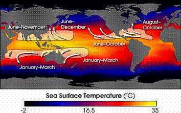
El Niño is defined by prolonged differences in Pacific Ocean surface temperatures when compared with the average value. The accepted definition is a warming or cooling of at least 0.5 °C (0.9 °F) averaged over the east-central tropical Pacific Ocean. Typically, this anomaly happens at irregular intervals of 2–7 years and lasts nine months to two years. The average period length is 5 years. When this warming or cooling occurs for only seven to nine months, it is classified as El Niño/La Niña "conditions"; when it occurs for more than that period, it is classified as El Niño/La Niña "episodes".
The sign of an El Niño in the sea surface temperature pattern is when warm water spreads from the west Pacific and the Indian Ocean
to the east Pacific. It takes the rain with it, causing extensive drought in the western Pacific and rainfall in the normally dry eastern Pacific. El Niño's warm rush of nutrient-poor tropical water, heated by its eastward passage in the Equatorial Current, replaces the cold, nutrient-rich surface water of the Humboldt Current
. When El Niño conditions last for many months, extensive ocean warming and the reduction in Easterly Trade winds limits upwelling of cold nutrient-rich deep water and its economic impact to local fishing for an international market can be serious.
Sea surface temperature affects the behavior of the Earth's atmosphere
above, so their initialization into atmospheric model
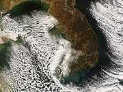
s is important. While sea surface temperature is important for tropical cyclogenesis, it is also important in determining the formation of sea fog and sea breezes. Heat from underlying warmer waters can significantly modify an air mass over distances as short as 35 kilometres (21.7 mi) to 40 kilometres (24.9 mi). For example, southwest of Northern Hemisphere extratropical cyclone
s, curved cyclonic flow bringing cold air across relatively warm water bodies can lead to narrow lake-effect snow (or sea effect) bands. Those bands bring strong localized precipitation
, often in the form of snow
, since large water bodies such as lakes efficiently store heat that results in significant temperature differences—larger than 13 C-change—between the water surface and the air above. Because of this temperature difference, warmth and moisture are transported upward, condensing into vertically-oriented clouds which produce snow showers. The temperature decrease with height and cloud depth are directly affected by both the water temperature and the large-scale environment. The stronger the temperature decrease with height, the taller the clouds get, and the greater the precipitation rate becomes.
Normally, an ocean temperature of 26.5°C (79.7°F) spanning through at least a 50-metre
depth is one of the six requirements needed to maintain the special mesocyclone
that is the tropical cyclone
. These warm waters are needed to maintain the warm core that fuels tropical systems. This value is well above 16.1 °C (60.9 °F), the long term global average surface temperature of the oceans. However, this requirement can be considered only a general baseline because it assumes that the ambient atmospheric environment surrounding an area of disturbed weather presents average conditions. Tropical cyclones have intensified when SSTs were slightly below this standard temperature.
Tropical cyclones are known to form even when normal conditions are not met. For example, cooler air temperatures at a higher altitude (e.g., at the 500 hPa
level, or 5.9 km) can lead to tropical cyclogenesis at lower water temperatures, as a certain lapse rate
is required to force the atmosphere to be unstable enough for convection. In a moist atmosphere, this lapse rate is 6.5 °C/km, while in an atmosphere with less than 100% relative humidity
, the required lapse rate is 9.8 °C/km.
At the 500 hPa level, the air temperature averages -7 °C (18 °F) within the tropics, but air in the tropics is normally dry at this height, giving the air room to wet-bulb
, or cool as it moistens, to a more favorable temperature that can then support convection. A wetbulb temperature at 500 hPa in a tropical atmosphere of -13.2 C is required to initiate convection if the water temperature is 26.5 °C (79.7 °F), and this temperature requirement increases or decreases proportionally by 1 °C in the sea surface temperature for each 1 °C change at 500 hpa.
Inside a cold cyclone
, 500 hPa temperatures can fall as low as -30 C, which can initiate convection even in the driest atmospheres. This also explains why moisture in the mid-levels of the troposphere
, roughly at the 500 hPa level, is normally a requirement for development. However, when dry air is found at the same height, temperatures at 500 hPa need to be even colder as dry atmospheres require a greater lapse rate for instability than moist atmospheres. At heights near the tropopause
, the 30-year average temperature (as measured in the period encompassing 1961 through 1990) was -77 °C (-132 °F). A recent example of a tropical cyclone
that maintained itself over cooler waters was Epsilon of the 2005 Atlantic hurricane season
.
Temperature
Temperature is a physical property of matter that quantitatively expresses the common notions of hot and cold. Objects of low temperature are cold, while various degrees of higher temperatures are referred to as warm or hot...
close to the ocean
Ocean
An ocean is a major body of saline water, and a principal component of the hydrosphere. Approximately 71% of the Earth's surface is covered by ocean, a continuous body of water that is customarily divided into several principal oceans and smaller seas.More than half of this area is over 3,000...
s surface. The exact meaning of surface varies according to the measurement method used, but it is between 1 millimetre (0.0393700787401575 in) and 20 metres (65.6 ft) below the sea
Sea
A sea generally refers to a large body of salt water, but the term is used in other contexts as well. Most commonly, it means a large expanse of saline water connected with an ocean, and is commonly used as a synonym for ocean...
surface. Air mass
Air mass
In meteorology, an air mass is a volume of air defined by its temperature and water vapor content. Air masses cover many hundreds or thousands of square miles, and adopt the characteristics of the surface below them. They are classified according to latitude and their continental or maritime...
es in the Earth's atmosphere
Earth's atmosphere
The atmosphere of Earth is a layer of gases surrounding the planet Earth that is retained by Earth's gravity. The atmosphere protects life on Earth by absorbing ultraviolet solar radiation, warming the surface through heat retention , and reducing temperature extremes between day and night...
are highly modified by sea surface temperatures within a short distance of the shore. Localized areas of heavy snow
Snow
Snow is a form of precipitation within the Earth's atmosphere in the form of crystalline water ice, consisting of a multitude of snowflakes that fall from clouds. Since snow is composed of small ice particles, it is a granular material. It has an open and therefore soft structure, unless packed by...
can form in bands
Rainband
A rainband is a cloud and precipitation structure associated with an area of rainfall which is significantly elongated. Rainbands can be stratiform or convective, and are generated by differences in temperature. When noted on weather radar imagery, this precipitation elongation is referred to as...
downwind of warm water bodies within an otherwise cold air mass. Warm sea surface temperatures are known to be a cause of tropical cyclogenesis
Tropical cyclogenesis
Tropical cyclogenesis is the term that describes the development and strengthening of a tropical cyclone in the atmosphere. The mechanisms through which tropical cyclogenesis occurs are distinctly different from those through which mid-latitude cyclogenesis occurs...
over the Earth's oceans. Tropical cyclones can also cause a cool wake, due to turbulent mixing of the upper 30 metres (98.4 ft) of the ocean. SST changes diurnally, like the air above it, but to a lesser degree due to its higher specific heat. There is less SST variation on breezy days than on calm days. In addition, ocean current
Ocean current
An ocean current is a continuous, directed movement of ocean water generated by the forces acting upon this mean flow, such as breaking waves, wind, Coriolis effect, cabbeling, temperature and salinity differences and tides caused by the gravitational pull of the Moon and the Sun...
s and the global thermohaline circulation affect average SST significantly throughout most of the world's oceans. For SSTs near the fringe of a landmass, offshore winds cause upwelling
Upwelling
Upwelling is an oceanographic phenomenon that involves wind-driven motion of dense, cooler, and usually nutrient-rich water towards the ocean surface, replacing the warmer, usually nutrient-depleted surface water. The increased availability in upwelling regions results in high levels of primary...
, which can cause significant cooling, but shallower waters over a continental shelf
Continental shelf
The continental shelf is the extended perimeter of each continent and associated coastal plain. Much of the shelf was exposed during glacial periods, but is now submerged under relatively shallow seas and gulfs, and was similarly submerged during other interglacial periods. The continental margin,...
are often warmer. Onshore winds can cause a considerable warm-up even in areas where upwelling is fairly constant, such as the northwest coast of South America
South America
South America is a continent situated in the Western Hemisphere, mostly in the Southern Hemisphere, with a relatively small portion in the Northern Hemisphere. The continent is also considered a subcontinent of the Americas. It is bordered on the west by the Pacific Ocean and on the north and east...
. Its values are important within numerical weather prediction
Numerical weather prediction
Numerical weather prediction uses mathematical models of the atmosphere and oceans to predict the weather based on current weather conditions. Though first attempted in the 1920s, it was not until the advent of computer simulation in the 1950s that numerical weather predictions produced realistic...
as the SST influences the atmosphere above, such as in the formation of sea breeze
Sea breeze
A sea-breeze is a wind from the sea that develops over land near coasts. It is formed by increasing temperature differences between the land and water; these create a pressure minimum over the land due to its relative warmth, and forces higher pressure, cooler air from the sea to move inland...
s and sea fog. It is also used to calibrate measurements from weather satellite
Weather satellite
The weather satellite is a type of satellite that is primarily used to monitor the weather and climate of the Earth. Satellites can be either polar orbiting, seeing the same swath of the Earth every 12 hours, or geostationary, hovering over the same spot on Earth by orbiting over the equator while...
s.
Measurement
There are a variety of techniques for measuring this parameter that can potentially yield different results because different things are actually being measured. Away from the immediate sea surface, general temperature measurements are accompanied by a reference to the specific depth of measurement. This is because of significant differences encountered between measurements made at different depths, especially during the daytime when low wind speed and high sunshine conditions may lead to the formation of a warm layer at the ocean's surface and strong vertical temperature gradients (a diurnal thermoclineThermocline
A thermocline is a thin but distinct layer in a large body of fluid , in which temperature changes more rapidly with depth than it does in the layers above or below...
). Sea surface temperature measurements are confined to the top portion of the ocean, known as the near-surface layer.
Thermometers
SST was one of the first oceanographic variables to be measured. Benjamin FranklinBenjamin Franklin
Dr. Benjamin Franklin was one of the Founding Fathers of the United States. A noted polymath, Franklin was a leading author, printer, political theorist, politician, postmaster, scientist, musician, inventor, satirist, civic activist, statesman, and diplomat...
suspended a mercury thermometer from a ship while travelling between the United States
United States
The United States of America is a federal constitutional republic comprising fifty states and a federal district...
and Europe
Europe
Europe is, by convention, one of the world's seven continents. Comprising the westernmost peninsula of Eurasia, Europe is generally 'divided' from Asia to its east by the watershed divides of the Ural and Caucasus Mountains, the Ural River, the Caspian and Black Seas, and the waterways connecting...
in his survey of the Gulf stream
Gulf Stream
The Gulf Stream, together with its northern extension towards Europe, the North Atlantic Drift, is a powerful, warm, and swift Atlantic ocean current that originates at the tip of Florida, and follows the eastern coastlines of the United States and Newfoundland before crossing the Atlantic Ocean...
in the late eighteenth century. SST was later measured by dipping a thermometer
Thermometer
Developed during the 16th and 17th centuries, a thermometer is a device that measures temperature or temperature gradient using a variety of different principles. A thermometer has two important elements: the temperature sensor Developed during the 16th and 17th centuries, a thermometer (from the...
into a bucket of water that was manually drawn from the sea surface. The first automated technique for determining SST was accomplished by measuring the temperature of water in the intake port of large ships, which was underway by 1963. These observations have a warm bias of around 0.6 C-change due to the heat of the engine room. This bias has led to changes in the perception of global warming
Global warming
Global warming refers to the rising average temperature of Earth's atmosphere and oceans and its projected continuation. In the last 100 years, Earth's average surface temperature increased by about with about two thirds of the increase occurring over just the last three decades...
since 2000. Fixed weather buoy
Weather buoy
Weather buoys are instruments which collect weather and ocean data within the world's oceans, as well as aiding during emergency response to chemical spills, legal proceedings, and engineering design. Moored buoys have been in used since 1951, while drifting buoys have been used since 1979...
s measure the water temperature at a depth of 3 metres (9.8 ft). Many different drifting buoys exist around the world that vary in design, and the location of reliable temperature sensors varies. These measurements are beamed to satellites for automated and immediate data distribution. A large network of coastal buoys in U.S. waters is maintained by the National Data Buoy Center
National Data Buoy Center
The National Data Buoy Center is a part of the National Oceanic and Atmospheric Administration's National Weather Service...
(NDBC). Between 1985 and 1994, an extensive array of moored and drifting buoys was deployed across the equatorial Pacific Ocean designed to help monitor and predict the El Niño phenomenon.
Weather satellites
Weather satellites have been available to determine sea surface temperature information since 1967, with the first global composites created during 1970. Since 1982, satelliteSatellite
In the context of spaceflight, a satellite is an object which has been placed into orbit by human endeavour. Such objects are sometimes called artificial satellites to distinguish them from natural satellites such as the Moon....
s have been increasingly utilized to measure SST and have allowed its spatial and temporal
Time
Time is a part of the measuring system used to sequence events, to compare the durations of events and the intervals between them, and to quantify rates of change such as the motions of objects....
variation to be viewed more fully. Satellite measurements of SST are in reasonable agreement with in situ
In situ
In situ is a Latin phrase which translated literally as 'In position'. It is used in many different contexts.-Aerospace:In the aerospace industry, equipment on board aircraft must be tested in situ, or in place, to confirm everything functions properly as a system. Individually, each piece may...
temperature measurements. The satellite measurement is made by sensing the ocean radiation
Radiation
In physics, radiation is a process in which energetic particles or energetic waves travel through a medium or space. There are two distinct types of radiation; ionizing and non-ionizing...
in two or more wavelengths within the infrared
Infrared
Infrared light is electromagnetic radiation with a wavelength longer than that of visible light, measured from the nominal edge of visible red light at 0.74 micrometres , and extending conventionally to 300 µm...
part of the electromagnetic spectrum
Electromagnetic spectrum
The electromagnetic spectrum is the range of all possible frequencies of electromagnetic radiation. The "electromagnetic spectrum" of an object is the characteristic distribution of electromagnetic radiation emitted or absorbed by that particular object....
or other parts of the spectrum which can then be empirically related to SST. These wavelengths are chosen because they are:
- within the peak of the blackbody radiation expected from the Earth, and
- able to transmit adequately well through the atmosphereEarth's atmosphereThe atmosphere of Earth is a layer of gases surrounding the planet Earth that is retained by Earth's gravity. The atmosphere protects life on Earth by absorbing ultraviolet solar radiation, warming the surface through heat retention , and reducing temperature extremes between day and night...
The satellite-measured SST provides both a synoptic view of the ocean and a high frequency of repeat views, allowing the examination of basin-wide upper ocean
Ocean
An ocean is a major body of saline water, and a principal component of the hydrosphere. Approximately 71% of the Earth's surface is covered by ocean, a continuous body of water that is customarily divided into several principal oceans and smaller seas.More than half of this area is over 3,000...
dynamics not possible with ships or buoys. NASA's (National Aeronautic and Space Administration) Moderate Resolution Imaging Spectroradiometer (MODIS) SST satellites have been providing global SST data since 2000, available with a one-day lag. NOAA's GOES (Geostationary Orbiting Earth Satellites) satellites are geo-stationary
Geostationary orbit
A geostationary orbit is a geosynchronous orbit directly above the Earth's equator , with a period equal to the Earth's rotational period and an orbital eccentricity of approximately zero. An object in a geostationary orbit appears motionless, at a fixed position in the sky, to ground observers...
above the Western Hemisphere which enables to them to deliver SST data on an hourly basis with only a few hours of lag time.
There are several difficulties with satellite-based absolute SST measurements. First, in infrared remote sensing methodology the radiation emanates from the top "skin" of the ocean
Sea surface microlayer
The sea surface microlayer is the top 1000 micrometers of the ocean surface. It is the boundary layer where all exchange occurs between the atmosphere and the ocean...
, approximately the top 0.01 mm
Millimetre
The millimetre is a unit of length in the metric system, equal to one thousandth of a metre, which is the SI base unit of length....
or less, which may not represent the bulk temperature
Bulk temperature
In fluid dynamics, the bulk temperature, or the average fluid bulk temperature, is a convenient reference point for evaluating properties related to convective heat transfer, particularly in applications related to flow in pipes and ducts....
of the upper meter of ocean due primarily to effects of solar surface heating during the daytime, reflected radiation, as well as sensible heat loss and surface evaporation. All these factors make it somewhat difficult to compare satellite data to measurements from buoys or shipboard methods, complicating ground truth efforts. Secondly, the satellite cannot look through clouds, creating a cool bias in satellite-derived SSTs within cloudy areas. However, passive microwave techniques can accurately measure SST and "see" through clouds. Within atmospheric sounder channels on weather satellite
Weather satellite
The weather satellite is a type of satellite that is primarily used to monitor the weather and climate of the Earth. Satellites can be either polar orbiting, seeing the same swath of the Earth every 12 hours, or geostationary, hovering over the same spot on Earth by orbiting over the equator while...
s, which peak just above the ocean's surface, knowledge of the sea surface temperature is important to their calibration.
Local variation
Aral Sea
The Aral Sea was a lake that lay between Kazakhstan in the north and Karakalpakstan, an autonomous region of Uzbekistan, in the south...
, temperatures near its bottom reaches a maximum in December and a minimum in May and June. Near the coastline, offshore winds move the warm waters near the surface offshore, and replace them with cooler water from below in the process known as Ekman transport
Ekman transport
Ekman transport, part of Ekman motion theory first investigated in 1902 by Vagn Walfrid Ekman , is the term given for the 90 degree net transport of the surface layer due to wind forcings...
. This pattern increases nutrients for marine life in the region. Offshore river delta
River delta
A delta is a landform that is formed at the mouth of a river where that river flows into an ocean, sea, estuary, lake, reservoir, flat arid area, or another river. Deltas are formed from the deposition of the sediment carried by the river as the flow leaves the mouth of the river...
s, freshwater flows over the top of the denser seawater, which allows it to heat faster due to limited vertical mixing. Remotely sensed SST can be used to detect the surface temperature signature due to tropical cyclone
Tropical cyclone
A tropical cyclone is a storm system characterized by a large low-pressure center and numerous thunderstorms that produce strong winds and heavy rain. Tropical cyclones strengthen when water evaporated from the ocean is released as the saturated air rises, resulting in condensation of water vapor...
s. In general, an SST cooling is observed after the passing of a hurricane primarily as the result of mixed layer deepening and surface heat losses. In the wake of several day long Saharan dust outbreaks across the adjacent northern Atlantic ocean, sea surface temperatures are reduced 0.2 C to 0.4 C (0.3 to 0.7 F). Other sources of short-term SST fluctuation include extratropical cyclone
Extratropical cyclone
Extratropical cyclones, sometimes called mid-latitude cyclones or wave cyclones, are a group of cyclones defined as synoptic scale low pressure weather systems that occur in the middle latitudes of the Earth having neither tropical nor polar characteristics, and are connected with fronts and...
s, rapid influxes of glacial
Glacier
A glacier is a large persistent body of ice that forms where the accumulation of snow exceeds its ablation over many years, often centuries. At least 0.1 km² in area and 50 m thick, but often much larger, a glacier slowly deforms and flows due to stresses induced by its weight...
fresh water and concentrated phytoplankton
Phytoplankton
Phytoplankton are the autotrophic component of the plankton community. The name comes from the Greek words φυτόν , meaning "plant", and πλαγκτός , meaning "wanderer" or "drifter". Most phytoplankton are too small to be individually seen with the unaided eye...
blooms due to seasonal cycles or agricultural run-off.
Unusually high sea surface temperatures have been implicated in some incidents involving marine animals and humans, including shark attack
Shark attack
A shark attack is an attack on a human by a shark. Every year around 60 shark attacks are reported worldwide, although death is quite unusual. Despite the relative rarity of shark attacks, the fear of sharks is a common phenomenon, having been fueled by the occasional instances of serial attacks,...
s such as the 2010 Sharm el-Sheikh shark attacks
2010 Sharm el-Sheikh shark attacks
The 2010 Sharm el-Sheikh shark attacks were a series of attacks by sharks on swimmers off the Red Sea resort of Sharm el-Sheikh in Egypt. On 1 December 2010, three Russians and one Ukrainian were seriously injured within minutes of each other, and on 5 December 2010 a German woman was killed, when...
, as the animals need more food to sustain a higher metabolism
Metabolism
Metabolism is the set of chemical reactions that happen in the cells of living organisms to sustain life. These processes allow organisms to grow and reproduce, maintain their structures, and respond to their environments. Metabolism is usually divided into two categories...
in those temperatures.
Regional variation
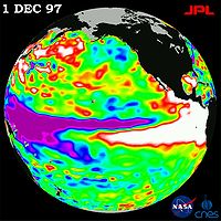
El Niño is defined by prolonged differences in Pacific Ocean surface temperatures when compared with the average value. The accepted definition is a warming or cooling of at least 0.5 °C (0.9 °F) averaged over the east-central tropical Pacific Ocean. Typically, this anomaly happens at irregular intervals of 2–7 years and lasts nine months to two years. The average period length is 5 years. When this warming or cooling occurs for only seven to nine months, it is classified as El Niño/La Niña "conditions"; when it occurs for more than that period, it is classified as El Niño/La Niña "episodes".
The sign of an El Niño in the sea surface temperature pattern is when warm water spreads from the west Pacific and the Indian Ocean
Indian Ocean
The Indian Ocean is the third largest of the world's oceanic divisions, covering approximately 20% of the water on the Earth's surface. It is bounded on the north by the Indian Subcontinent and Arabian Peninsula ; on the west by eastern Africa; on the east by Indochina, the Sunda Islands, and...
to the east Pacific. It takes the rain with it, causing extensive drought in the western Pacific and rainfall in the normally dry eastern Pacific. El Niño's warm rush of nutrient-poor tropical water, heated by its eastward passage in the Equatorial Current, replaces the cold, nutrient-rich surface water of the Humboldt Current
Humboldt Current
The Humboldt Current , also known as the Peru Current, is a cold, low-salinity ocean current that flows north-westward along the west coast of South America from the southern tip of Chile to northern Peru. It is an eastern boundary current flowing in the direction of the equator, and can extend...
. When El Niño conditions last for many months, extensive ocean warming and the reduction in Easterly Trade winds limits upwelling of cold nutrient-rich deep water and its economic impact to local fishing for an international market can be serious.
Importance to the Earth's atmosphere
Sea surface temperature affects the behavior of the Earth's atmosphere
Earth's atmosphere
The atmosphere of Earth is a layer of gases surrounding the planet Earth that is retained by Earth's gravity. The atmosphere protects life on Earth by absorbing ultraviolet solar radiation, warming the surface through heat retention , and reducing temperature extremes between day and night...
above, so their initialization into atmospheric model
Atmospheric model
An atmospheric model is a mathematical model constructed around the full set of primitive dynamical equations which govern atmospheric motions. It can supplement these equations with parameterizations for turbulent diffusion, radiation, moist processes , heat exchange, soil, vegetation, surface...
s is important. While sea surface temperature is important for tropical cyclogenesis, it is also important in determining the formation of sea fog and sea breezes. Heat from underlying warmer waters can significantly modify an air mass over distances as short as 35 kilometres (21.7 mi) to 40 kilometres (24.9 mi). For example, southwest of Northern Hemisphere extratropical cyclone
Extratropical cyclone
Extratropical cyclones, sometimes called mid-latitude cyclones or wave cyclones, are a group of cyclones defined as synoptic scale low pressure weather systems that occur in the middle latitudes of the Earth having neither tropical nor polar characteristics, and are connected with fronts and...
s, curved cyclonic flow bringing cold air across relatively warm water bodies can lead to narrow lake-effect snow (or sea effect) bands. Those bands bring strong localized precipitation
Precipitation (meteorology)
In meteorology, precipitation In meteorology, precipitation In meteorology, precipitation (also known as one of the classes of hydrometeors, which are atmospheric water phenomena is any product of the condensation of atmospheric water vapor that falls under gravity. The main forms of precipitation...
, often in the form of snow
Snow
Snow is a form of precipitation within the Earth's atmosphere in the form of crystalline water ice, consisting of a multitude of snowflakes that fall from clouds. Since snow is composed of small ice particles, it is a granular material. It has an open and therefore soft structure, unless packed by...
, since large water bodies such as lakes efficiently store heat that results in significant temperature differences—larger than 13 C-change—between the water surface and the air above. Because of this temperature difference, warmth and moisture are transported upward, condensing into vertically-oriented clouds which produce snow showers. The temperature decrease with height and cloud depth are directly affected by both the water temperature and the large-scale environment. The stronger the temperature decrease with height, the taller the clouds get, and the greater the precipitation rate becomes.
Tropical cyclones
Normally, an ocean temperature of 26.5°C (79.7°F) spanning through at least a 50-metre
Metre
The metre , symbol m, is the base unit of length in the International System of Units . Originally intended to be one ten-millionth of the distance from the Earth's equator to the North Pole , its definition has been periodically refined to reflect growing knowledge of metrology...
depth is one of the six requirements needed to maintain the special mesocyclone
Mesocyclone
A mesocyclone is a vortex of air, approximately 2 to 10 miles in diameter , within a convective storm....
that is the tropical cyclone
Tropical cyclone
A tropical cyclone is a storm system characterized by a large low-pressure center and numerous thunderstorms that produce strong winds and heavy rain. Tropical cyclones strengthen when water evaporated from the ocean is released as the saturated air rises, resulting in condensation of water vapor...
. These warm waters are needed to maintain the warm core that fuels tropical systems. This value is well above 16.1 °C (60.9 °F), the long term global average surface temperature of the oceans. However, this requirement can be considered only a general baseline because it assumes that the ambient atmospheric environment surrounding an area of disturbed weather presents average conditions. Tropical cyclones have intensified when SSTs were slightly below this standard temperature.
Tropical cyclones are known to form even when normal conditions are not met. For example, cooler air temperatures at a higher altitude (e.g., at the 500 hPa
HPA
-Organizations:*Halifax Port Authority, a port authority in Canada*Hamburg Port Authority, the port authority for the Port of Hamburg, Germany*Health Protection Agency, a health organization in the United Kingdom...
level, or 5.9 km) can lead to tropical cyclogenesis at lower water temperatures, as a certain lapse rate
Lapse rate
The lapse rate is defined as the rate of decrease with height for an atmospheric variable. The variable involved is temperature unless specified otherwise. The terminology arises from the word lapse in the sense of a decrease or decline; thus, the lapse rate is the rate of decrease with height and...
is required to force the atmosphere to be unstable enough for convection. In a moist atmosphere, this lapse rate is 6.5 °C/km, while in an atmosphere with less than 100% relative humidity
Relative humidity
Relative humidity is a term used to describe the amount of water vapor in a mixture of air and water vapor. It is defined as the partial pressure of water vapor in the air-water mixture, given as a percentage of the saturated vapor pressure under those conditions...
, the required lapse rate is 9.8 °C/km.
At the 500 hPa level, the air temperature averages -7 °C (18 °F) within the tropics, but air in the tropics is normally dry at this height, giving the air room to wet-bulb
Wet-bulb temperature
The wet-bulb temperature is a type of temperature measurement that reflects the physical properties of a system with a mixture of a gas and a vapor, usually air and water vapor. Wet bulb temperature is the lowest temperature that can be reached by the evaporation of water only. It is the...
, or cool as it moistens, to a more favorable temperature that can then support convection. A wetbulb temperature at 500 hPa in a tropical atmosphere of -13.2 C is required to initiate convection if the water temperature is 26.5 °C (79.7 °F), and this temperature requirement increases or decreases proportionally by 1 °C in the sea surface temperature for each 1 °C change at 500 hpa.
Inside a cold cyclone
Cold-core low
A cold-core low, also known as a cold low or cold-core cyclone, is a cyclone aloft which has an associated cold pool of air residing at high altitude within the Earth's troposphere. It is a low pressure system which strengthens with height in accordance with the thermal wind relationship. These...
, 500 hPa temperatures can fall as low as -30 C, which can initiate convection even in the driest atmospheres. This also explains why moisture in the mid-levels of the troposphere
Troposphere
The troposphere is the lowest portion of Earth's atmosphere. It contains approximately 80% of the atmosphere's mass and 99% of its water vapor and aerosols....
, roughly at the 500 hPa level, is normally a requirement for development. However, when dry air is found at the same height, temperatures at 500 hPa need to be even colder as dry atmospheres require a greater lapse rate for instability than moist atmospheres. At heights near the tropopause
Tropopause
The tropopause is the atmospheric boundary between the troposphere and the stratosphere.-Definition:Going upward from the surface, it is the point where air ceases to cool with height, and becomes almost completely dry...
, the 30-year average temperature (as measured in the period encompassing 1961 through 1990) was -77 °C (-132 °F). A recent example of a tropical cyclone
Tropical cyclone
A tropical cyclone is a storm system characterized by a large low-pressure center and numerous thunderstorms that produce strong winds and heavy rain. Tropical cyclones strengthen when water evaporated from the ocean is released as the saturated air rises, resulting in condensation of water vapor...
that maintained itself over cooler waters was Epsilon of the 2005 Atlantic hurricane season
2005 Atlantic hurricane season
The 2005 Atlantic hurricane season was the most active Atlantic hurricane season in recorded history, repeatedly shattering numerous records. The impact of the season was widespread and ruinous with an estimated 3,913 deaths and record damage of about $159.2 billion...
.
See also
- Atlantic Multidecadal OscillationAtlantic Multidecadal OscillationThe Atlantic multidecadal oscillation is a mode of variability occurring in the North Atlantic Ocean and which has its principal expression in the sea surface temperature field...
(AMO) - Current sea level riseCurrent sea level riseCurrent sea level rise potentially impacts human populations and the wider natural environment . Global average sea level rose at an average rate of around 1.8 mm per year over 1961 to 2003 and at an average rate of about 3.1 mm per year from 1993 to 2003...
can occur during an increase of global or regional average SST - HaloclineHaloclineIn oceanography, a halocline is a subtype of chemocline caused by a strong, vertical salinity gradient within a body of water. Because salinity affects the density of seawater, it can play a role in its vertical stratification...
refers to a salinity difference often altered by temperature-dependent factors - Loop CurrentLoop CurrentA parent to the Florida Current, the Loop Current is a warm ocean current in the Gulf of Mexico that flows northward between Cuba and the Yucatán peninsula, moves north into the Gulf of Mexico, loops east and south before exiting to the east through the Florida Straits and joining the Gulf Stream.A...
, with plots of sea temperature in the Gulf of MexicoGulf of MexicoThe Gulf of Mexico is a partially landlocked ocean basin largely surrounded by the North American continent and the island of Cuba. It is bounded on the northeast, north and northwest by the Gulf Coast of the United States, on the southwest and south by Mexico, and on the southeast by Cuba. In... - Pacific Decadal OscillationPacific decadal oscillationThe Pacific Decadal Oscillation is a pattern of Pacific climate variability that shifts phases on at least inter-decadal time scale, usually about 20 to 30 years. The PDO is detected as warm or cool surface waters in the Pacific Ocean, north of 20° N...
(PDO) - PlanktonPlanktonPlankton are any drifting organisms that inhabit the pelagic zone of oceans, seas, or bodies of fresh water. That is, plankton are defined by their ecological niche rather than phylogenetic or taxonomic classification...
, which blooms at rates dependant on sea surface temperature - SalinitySalinitySalinity is the saltiness or dissolved salt content of a body of water. It is a general term used to describe the levels of different salts such as sodium chloride, magnesium and calcium sulfates, and bicarbonates...
, which affects sea surface evaporation and thus temperature - Ghrsst-ppGhrsst-ppThe Group for High Resolution SST is a follow on activity form the Global Ocean Data Assimilation Experiment high-resolution sea surface temperature pilot project provides a new generation of global high-resolution The Group for High Resolution SST (GHRSST) is a follow on activity form the...
the Group for High Resolution SST
External links
- NASA's Physical Oceanography Distributed Active Archive Center (PO.DAAC) Provider of historic and near real time SST data from 14 satellites, spanning 1981 through yesterday
- NOAA Sea Surface Temperature (SST) Contour Charts
- Data Buoy Cooperation Panel
- SQUAM, SST Quality Monitor (A near real-time Global QC Tool for monitoring time-series stability & cross-platform consistency of satellite SST)
- iQuam, in situ SST Quality Monitor (A near real-time quality control & monitoring system for in situ SST measured by ships and buoys)
- MICROS, Monitoring of IR Clear-sky Radiances over Oceans for SST
- Sea Temperatures, Current sea temperatures around the world.