
1961 Atlantic hurricane season
Encyclopedia
The 1961 Atlantic hurricane season officially began on June 15, 1961, and lasted until November 15, 1961. These dates conventionally delimit the period of each year when most tropical cyclone
s form in the Atlantic basin
. The season
had seven major hurricanes, the second highest number on record, despite having only eight total hurricanes. It is also one of only four seasons to have two or more hurricanes reach Category 5 status on the Saffir-Simpson Hurricane Scale
, the others being the 1960
, 2005
, and the 2007 season
.
The most notable hurricanes of the season were the two Category 5 hurricanes. Hurricane Carla
struck Texas, killing 49 and causing $325 million (1961 USD, $ USD) in damage. Hurricane Hattie
devastated Belize
, killing 200; Belize City
was largely destroyed, leading to the eventual (1970) relocation of the national capital to Belmopan
.
developed a tropical storm on July 20 over the southern Leeward Islands
. An upper level anticyclone allowed continued development, and Anna became a hurricane that night while moving westward across the Caribbean Sea
. The hurricane continued to intensify, and reached its peak of 115 mph (185 km/h) the next day. It maintained that intensity until July 23, when land interaction with Honduras
weakened it to a Category 2. There, Anna caused heavy flooding as it continued westward. It reached the coast of Belize
on July 24 as a minimal hurricane, and dissipated shortly thereafter. Anna caused a total of $300,000 in damage (1961 USD, $ USD) and one death in Honduras.
. Betsy became extratropical on September 12, and dissipated that day. It was one of three active hurricanes from September 7 to September 11, a rare event in the Atlantic.
. Carla was one of the most intense hurricanes to make landfall in the United States
, with a central pressure of 931 mbar (27.5 inHg) and estimated wind speeds of 150 mph (240 km/h). Although the scale did not exist in 1961, Carla is now considered to be a Category 5 on the Saffir-Simpson Hurricane Scale
while over open waters.
. Hurricane Debbie and its remnants caused heavy damage across the United Kingdom
and 11 deaths in Ireland.
that reached a peak intensity at Category 4 status. Esther threatened New England twice before hitting Maine
as a tropical storm in late September. Esther was responsible for $6 million (1961 USD, $ USD) in damage, but no direct deaths were reported. However, Esther did cause seven indirect deaths when a Navy P5M aircraft crashed 120 miles (193.1 km) off the coast of Bermuda
.
on September 14. It remained weak as it raced through the East Coast states, dissipating on September 15 in the Gulf of St. Lawrence. It is notably one of the fastest moving tropical cyclones in history.
. It crossed the islands the next day as a tropical storm, and turned northward as a disorganized system. The lack of divergence at high levels disallowed further strengthening until later. Frances hit the eastern tip of Dominican Republic
on October 3, and continued north and northeastward. It was able to finally organize on October 4, and Frances steadily strengthened to a 125 mph (205 km/h) major hurricane. It turned to the northwest and posed a threat to Maine, but it turned abrubtly right. Moving over cooler waters, Frances gradually lost intensity, and became extratropical on October 9 near Nova Scotia
.
that night and Cuba
the next day. Upper-level shear kept the depression disorganized, but when it reached the Atlantic, the shear relaxed somewhat, allowing the depression to become a tropical storm on October 19. Shortly after reaching a peak of 70 mph (110 km/h) on October 20 while racing to the northeast, Gerda became extratropical, retaining its circulation for two more days until dissipating. Gerda caused five deaths in Jamaica and seven in Cuba.
on October 27, hit Central America
as a strong Category 4. The storm caused enormous damage in Central America, with an estimated death toll of 265, almost all in Belize
. Advance warning of the storm is credited with reducing the number of fatalities, as the storm was reportedly worse than a similar hurricane that killed 2,500 people in 1931. Hattie destroyed an estimated 40% of all buildings in Belize, and damaged half of those that remained; Belize City
was damaged so heavily that the national government was relocated inland to Belmopan
. Like Carla, Hattie was also classified posthumously as a Category 5
storm. Hattie held Category 5 intensity on the dates of October 30 and October 31, making it the latest Category 5 storm on record in the Atlantic basin.
, became a tropical depression over the northeastern Lesser Antilles on November 1. After moving northeastward, the tropical depression moved eastward in response to an upper level trough. Subtropical in nature, it was able to withstand the shear, and, after looping back to the west, became a tropical storm on November 6. Later that day, Jenny became a hurricane, but as it turned northeastward, shear and cooler waters weakened it. Jenny became extratropical on November 8.
As a tropical depression, Jenny produced moderate rainfall in Puerto Rico, peaking at 4.97 in (126.2 mm).
Tropical cyclone
A tropical cyclone is a storm system characterized by a large low-pressure center and numerous thunderstorms that produce strong winds and heavy rain. Tropical cyclones strengthen when water evaporated from the ocean is released as the saturated air rises, resulting in condensation of water vapor...
s form in the Atlantic basin
Atlantic Basin
The Atlantic Basin is the Atlantic Ocean.Atlantic Basin may also refer to:* Atlantic Basin Iron Works, an ironworks that operated in Brooklyn, New York, in the early to mid-20th century...
. The season
Atlantic hurricane season
The Atlantic hurricane season is the period in a year when hurricanes usually form in the Atlantic Ocean. Tropical cyclones in the North Atlantic are called hurricanes, tropical storms, or tropical depressions. In addition, there have been several storms over the years that have not been fully...
had seven major hurricanes, the second highest number on record, despite having only eight total hurricanes. It is also one of only four seasons to have two or more hurricanes reach Category 5 status on the Saffir-Simpson Hurricane Scale
Saffir-Simpson Hurricane Scale
The Saffir–Simpson Hurricane Scale , or the Saffir–Simpson Hurricane Wind Scale , classifies hurricanes — Western Hemisphere tropical cyclones that exceed the intensities of tropical depressions and tropical storms — into five categories distinguished by the intensities of their sustained winds...
, the others being the 1960
1960 Atlantic hurricane season
The 1960 Atlantic hurricane season was the least active Atlantic hurricane season since 1952. The season officially began on June 15, 1960, and lasted until November 15, 1960. These dates conventionally delimit the period of each year when most tropical cyclones form in the Atlantic basin...
, 2005
2005 Atlantic hurricane season
The 2005 Atlantic hurricane season was the most active Atlantic hurricane season in recorded history, repeatedly shattering numerous records. The impact of the season was widespread and ruinous with an estimated 3,913 deaths and record damage of about $159.2 billion...
, and the 2007 season
2007 Atlantic hurricane season
The 2007 Atlantic hurricane season was an active Atlantic hurricane season that produced 17 tropical cyclones, 15 tropical storms, six hurricanes, and two major hurricanes. It officially started on June 1 and ended on November 30, dates which conventionally delimit the...
.
The most notable hurricanes of the season were the two Category 5 hurricanes. Hurricane Carla
Hurricane Carla
Hurricane Carla was one of two Category 5 tropical cyclones during the 1961 Atlantic hurricane season. It struck the Texas coast as a Category 4 hurricane, becoming one of the most powerful storms to ever strike the United States. Hurricane Carla was the second most intense storm to ever...
struck Texas, killing 49 and causing $325 million (1961 USD, $ USD) in damage. Hurricane Hattie
Hurricane Hattie
Hurricane Hattie was the deadliest tropical cyclone of the 1961 Atlantic hurricane season, as well as the strongest, reaching a peak intensity equivalent to Category 5 hurricane intensity...
devastated Belize
Belize
Belize is a constitutional monarchy and the northernmost country in Central America. Belize has a diverse society, comprising many cultures and languages. Even though Kriol and Spanish are spoken among the population, Belize is the only country in Central America where English is the official...
, killing 200; Belize City
Belize City
Belize City is the largest city in the Central American nation of Belize. Unofficial estimates place the population of Belize City at 70,000 or more. It is located at the mouth of the Belize River on the coast of the Caribbean. The city is the country's principal port and its financial and...
was largely destroyed, leading to the eventual (1970) relocation of the national capital to Belmopan
Belmopan
Belmopan , estimated population 20,000 is the capital city of Belize.Belmopan is located at , at an altitude of 76 metres above sea level. Belmopan was constructed just to the east of Belize River, inland from the former capital, the port of Belize City, after that city's near destruction by...
.
Hurricane Anna
The Intertropical Convergence ZoneIntertropical Convergence Zone
The Intertropical Convergence Zone , known by sailors as The Doldrums, is the area encircling the earth near the equator where winds originating in the northern and southern hemispheres come together....
developed a tropical storm on July 20 over the southern Leeward Islands
Leeward Islands
The Leeward Islands are a group of islands in the West Indies. They are the northern islands of the Lesser Antilles chain. As a group they start east of Puerto Rico and reach southward to Dominica. They are situated where the northeastern Caribbean Sea meets the western Atlantic Ocean...
. An upper level anticyclone allowed continued development, and Anna became a hurricane that night while moving westward across the Caribbean Sea
Caribbean Sea
The Caribbean Sea is a sea of the Atlantic Ocean located in the tropics of the Western hemisphere. It is bounded by Mexico and Central America to the west and southwest, to the north by the Greater Antilles, and to the east by the Lesser Antilles....
. The hurricane continued to intensify, and reached its peak of 115 mph (185 km/h) the next day. It maintained that intensity until July 23, when land interaction with Honduras
Honduras
Honduras is a republic in Central America. It was previously known as Spanish Honduras to differentiate it from British Honduras, which became the modern-day state of Belize...
weakened it to a Category 2. There, Anna caused heavy flooding as it continued westward. It reached the coast of Belize
Belize
Belize is a constitutional monarchy and the northernmost country in Central America. Belize has a diverse society, comprising many cultures and languages. Even though Kriol and Spanish are spoken among the population, Belize is the only country in Central America where English is the official...
on July 24 as a minimal hurricane, and dissipated shortly thereafter. Anna caused a total of $300,000 in damage (1961 USD, $ USD) and one death in Honduras.
Hurricane Betsy
A westward moving tropical wave became Tropical Storm Betsy on September 2 in the Tropical Atlantic. It moved northwestward with favorable conditions aloft, and steadily strengthened until its peak of 140 mph (220 km/h) on September 5. A trough off the east coast of the United States pushed Betsy northeastward, where it maintained hurricane strength until September 11, west-southwest of IrelandIreland
Ireland is an island to the northwest of continental Europe. It is the third-largest island in Europe and the twentieth-largest island on Earth...
. Betsy became extratropical on September 12, and dissipated that day. It was one of three active hurricanes from September 7 to September 11, a rare event in the Atlantic.
Hurricane Carla
Hurricane Carla caused 46 deaths (31 of them in Texas) and $325 million (1961 USD, $ USD) in damage when it made landfall near Port Lavaca, TexasPort Lavaca, Texas
Port Lavaca is a city in Calhoun County, Texas, United States. The population was 12,248 at the 2010 census. The County had a 3.6% growth which brought the county population to 21,381. The city itself is bringing in more business into the area. It is the county seat of Calhoun County...
. Carla was one of the most intense hurricanes to make landfall in the United States
United States
The United States of America is a federal constitutional republic comprising fifty states and a federal district...
, with a central pressure of 931 mbar (27.5 inHg) and estimated wind speeds of 150 mph (240 km/h). Although the scale did not exist in 1961, Carla is now considered to be a Category 5 on the Saffir-Simpson Hurricane Scale
Saffir-Simpson Hurricane Scale
The Saffir–Simpson Hurricane Scale , or the Saffir–Simpson Hurricane Wind Scale , classifies hurricanes — Western Hemisphere tropical cyclones that exceed the intensities of tropical depressions and tropical storms — into five categories distinguished by the intensities of their sustained winds...
while over open waters.
Hurricane Debbie
The precursor to Hurricane Debbie was a tropical wave that moved off the coast of Africa. It became Tropical Storm Debbie on September 6, and it reached hurricane strength on the September 7. It moved northwestward, reaching a peak intensity of 120 mph (195 km/h) on September 11, but a trough of low pressure pushed Debbie northeastward towards unfavorable conditions. As Debbie raced northeastward, it maintained tropical characteristics until September 16, when it became extratropical just southwest of IrelandIreland
Ireland is an island to the northwest of continental Europe. It is the third-largest island in Europe and the twentieth-largest island on Earth...
. Hurricane Debbie and its remnants caused heavy damage across the United Kingdom
United Kingdom
The United Kingdom of Great Britain and Northern IrelandIn the United Kingdom and Dependencies, other languages have been officially recognised as legitimate autochthonous languages under the European Charter for Regional or Minority Languages...
and 11 deaths in Ireland.
Hurricane Esther
Hurricane Esther was a long-lasting hurricane and powerful Cape Verde-type hurricaneCape Verde-type hurricane
A Cape Verde-type hurricane is an Atlantic hurricane that develops near the Cape Verde islands, off the west coast of Africa. The average hurricane season has about two Cape Verde-type hurricanes, which are usually the largest and most intense storms of the season because they often have plenty of...
that reached a peak intensity at Category 4 status. Esther threatened New England twice before hitting Maine
Maine
Maine is a state in the New England region of the northeastern United States, bordered by the Atlantic Ocean to the east and south, New Hampshire to the west, and the Canadian provinces of Quebec to the northwest and New Brunswick to the northeast. Maine is both the northernmost and easternmost...
as a tropical storm in late September. Esther was responsible for $6 million (1961 USD, $ USD) in damage, but no direct deaths were reported. However, Esther did cause seven indirect deaths when a Navy P5M aircraft crashed 120 miles (193.1 km) off the coast of Bermuda
Bermuda
Bermuda is a British overseas territory in the North Atlantic Ocean. Located off the east coast of the United States, its nearest landmass is Cape Hatteras, North Carolina, about to the west-northwest. It is about south of Halifax, Nova Scotia, Canada, and northeast of Miami, Florida...
.
Unnamed Tropical Storm
A tropical depression formed over the Bahamas on September 12. It moved northward, and became a tropical storm just after hitting near Wilmington, North CarolinaWilmington, North Carolina
Wilmington is a port city in and is the county seat of New Hanover County, North Carolina, United States. The population is 106,476 according to the 2010 Census, making it the eighth most populous city in the state of North Carolina...
on September 14. It remained weak as it raced through the East Coast states, dissipating on September 15 in the Gulf of St. Lawrence. It is notably one of the fastest moving tropical cyclones in history.
Hurricane Frances
A westward moving tropical wave organized into a tropical depression on September 30, east of the northern Lesser AntillesLesser Antilles
The Lesser Antilles are a long, partly volcanic island arc in the Western Hemisphere. Most of its islands form the eastern boundary of the Caribbean Sea with the Atlantic Ocean, with the remainder located in the southern Caribbean just north of South America...
. It crossed the islands the next day as a tropical storm, and turned northward as a disorganized system. The lack of divergence at high levels disallowed further strengthening until later. Frances hit the eastern tip of Dominican Republic
Dominican Republic
The Dominican Republic is a nation on the island of La Hispaniola, part of the Greater Antilles archipelago in the Caribbean region. The western third of the island is occupied by the nation of Haiti, making Hispaniola one of two Caribbean islands that are shared by two countries...
on October 3, and continued north and northeastward. It was able to finally organize on October 4, and Frances steadily strengthened to a 125 mph (205 km/h) major hurricane. It turned to the northwest and posed a threat to Maine, but it turned abrubtly right. Moving over cooler waters, Frances gradually lost intensity, and became extratropical on October 9 near Nova Scotia
Nova Scotia
Nova Scotia is one of Canada's three Maritime provinces and is the most populous province in Atlantic Canada. The name of the province is Latin for "New Scotland," but "Nova Scotia" is the recognized, English-language name of the province. The provincial capital is Halifax. Nova Scotia is the...
.
Tropical Storm Gerda
The precursor to Tropical Storm Gerda was a tropical wave that developed on October 16 in the Caribbean Sea. The tropical depression moved slowly northward, moving over JamaicaJamaica
Jamaica is an island nation of the Greater Antilles, in length, up to in width and 10,990 square kilometres in area. It is situated in the Caribbean Sea, about south of Cuba, and west of Hispaniola, the island harbouring the nation-states Haiti and the Dominican Republic...
that night and Cuba
Cuba
The Republic of Cuba is an island nation in the Caribbean. The nation of Cuba consists of the main island of Cuba, the Isla de la Juventud, and several archipelagos. Havana is the largest city in Cuba and the country's capital. Santiago de Cuba is the second largest city...
the next day. Upper-level shear kept the depression disorganized, but when it reached the Atlantic, the shear relaxed somewhat, allowing the depression to become a tropical storm on October 19. Shortly after reaching a peak of 70 mph (110 km/h) on October 20 while racing to the northeast, Gerda became extratropical, retaining its circulation for two more days until dissipating. Gerda caused five deaths in Jamaica and seven in Cuba.
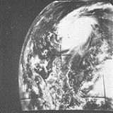
Hurricane Hattie
Hurricane Hattie, which formed in the Caribbean SeaCaribbean Sea
The Caribbean Sea is a sea of the Atlantic Ocean located in the tropics of the Western hemisphere. It is bounded by Mexico and Central America to the west and southwest, to the north by the Greater Antilles, and to the east by the Lesser Antilles....
on October 27, hit Central America
Central America
Central America is the central geographic region of the Americas. It is the southernmost, isthmian portion of the North American continent, which connects with South America on the southeast. When considered part of the unified continental model, it is considered a subcontinent...
as a strong Category 4. The storm caused enormous damage in Central America, with an estimated death toll of 265, almost all in Belize
Belize
Belize is a constitutional monarchy and the northernmost country in Central America. Belize has a diverse society, comprising many cultures and languages. Even though Kriol and Spanish are spoken among the population, Belize is the only country in Central America where English is the official...
. Advance warning of the storm is credited with reducing the number of fatalities, as the storm was reportedly worse than a similar hurricane that killed 2,500 people in 1931. Hattie destroyed an estimated 40% of all buildings in Belize, and damaged half of those that remained; Belize City
Belize City
Belize City is the largest city in the Central American nation of Belize. Unofficial estimates place the population of Belize City at 70,000 or more. It is located at the mouth of the Belize River on the coast of the Caribbean. The city is the country's principal port and its financial and...
was damaged so heavily that the national government was relocated inland to Belmopan
Belmopan
Belmopan , estimated population 20,000 is the capital city of Belize.Belmopan is located at , at an altitude of 76 metres above sea level. Belmopan was constructed just to the east of Belize River, inland from the former capital, the port of Belize City, after that city's near destruction by...
. Like Carla, Hattie was also classified posthumously as a Category 5
Saffir-Simpson Hurricane Scale
The Saffir–Simpson Hurricane Scale , or the Saffir–Simpson Hurricane Wind Scale , classifies hurricanes — Western Hemisphere tropical cyclones that exceed the intensities of tropical depressions and tropical storms — into five categories distinguished by the intensities of their sustained winds...
storm. Hattie held Category 5 intensity on the dates of October 30 and October 31, making it the latest Category 5 storm on record in the Atlantic basin.
Hurricane Jenny
An area of disturbed weather, in connection with the development of a cut-off low in the upper troposphere over Puerto RicoPuerto Rico
Puerto Rico , officially the Commonwealth of Puerto Rico , is an unincorporated territory of the United States, located in the northeastern Caribbean, east of the Dominican Republic and west of both the United States Virgin Islands and the British Virgin Islands.Puerto Rico comprises an...
, became a tropical depression over the northeastern Lesser Antilles on November 1. After moving northeastward, the tropical depression moved eastward in response to an upper level trough. Subtropical in nature, it was able to withstand the shear, and, after looping back to the west, became a tropical storm on November 6. Later that day, Jenny became a hurricane, but as it turned northeastward, shear and cooler waters weakened it. Jenny became extratropical on November 8.
As a tropical depression, Jenny produced moderate rainfall in Puerto Rico, peaking at 4.97 in (126.2 mm).
Tropical Storm Inga
Tropical Storm Inga formed on November 5, the only time a tropical storm formed in the Gulf in the month of November. Inga's center moved westward, followed by a new center forming to the southeast. It drifted over the Bay of Campeche for the next few days, and after reaching a peak of 70 mph (110 km/h), dissipated on November 8.Season effects
This is a table of the storms in 1961 and their landfall(s), if any. Deaths in parentheses are additional and indirect (an example of an indirect death would be a traffic accident), but are still storm-related. Damage and deaths include totals while the storm was extratropical or a wave or low.Storm names
The following names were used for named storms (tropical storms and hurricanes) that formed in the North Atlantic in 1961. Storms were named Frances, Hattie, Inga and Jenny for the first time in 1961. Names that were not assigned are marked in .
|
Hurricane Hattie Hurricane Hattie was the deadliest tropical cyclone of the 1961 Atlantic hurricane season, as well as the strongest, reaching a peak intensity equivalent to Category 5 hurricane intensity... |
Retirement
The names Carla and Hattie were later retired.See also
- List of Atlantic hurricanes
- List of Atlantic hurricane seasons