
Hurricane Michelle
Encyclopedia
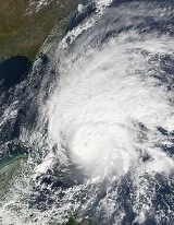
Hurricane Michelle was the thirteenth named storm and the strongest tropical cyclone
of the 2001 Atlantic hurricane season
. Michelle developed from a tropical wave
that moved across the Atlantic, and formed into Tropical Depression Fifteen on the October 29. The depression slowly intensified as forming, and became Tropical Storm Michelle on November 1. It strengthened more, until reaching its peak strength as a Category 4. One of only five November Category 4 hurricanes, Michelle made landfall on south-central Cuba
with winds of 140 mph (225 km/h), the strongest Cuban landfall since Hurricane Fox
in the 1952 season
.
The hurricane brought torrential rains across its path from Central America
through the Greater Antilles
, especially in the countries of Cuba and Honduras. In total, Michelle caused 17 fatalities and $2 billion (2001 USD; $ USD) in damage. As a result of the severe affects, the name Michelle was retired following the season.
moved off of the west coast of Africa
on October 16. The tropical wave moved across the open Atlantic, and reached the Lesser Antilles
on October 23. Still a weak tropical wave, shower activity increased on October 26, when the wave was located in the Caribbean. At this time, a broad low-pressure area developed near the coast of Nicaragua. A gradual strengthening period began, and a Hurricane Hunters aircraft had found that the tropical wave had intensified to a tropical depression on October 29.
The depression meandered over Nicaragua
for 36 hours. A north-northeastward track that began early on October 31 brought the center back over the Caribbean
waters later that day near Cabo Gracias a Dios on the border between Honduras
and Nicaragua
. The system strengthened and was named Tropical Storm Michelle on November 1, to the north of Cabo Gracias. Michelle moved slowly north-northwestward on November 1 and steadily intensified. It became a hurricane on November 2 while it tracked slowly northward. Rapid intensification then occurred. The central pressure fell from 988 mb on November 2 to 937 mb on the November 3 – a decrease of 51 mb in about 29 hours. Michelle turned slowly north-northeastward after November 3, while some fluctuations in intensity occurred. It reached a peak intensity of 140 mph (225 km/h) on November 4 while accelerating northeastward. This motion brought the center of Michelle to the off the southwest shore of Cuba, that day as a Category 4 hurricane on the Saffir–Simpson Hurricane Scale, and to the Cuban mainland near the Bay of Pigs
about five hours later. Michelle's circulation was disrupted by Cuba's landmass. It then accelerated northeastward through the Bahamas. The center moved off the coast of Cuba
, passed over Andros Island, and over Eleuthera Island. Michelle became a vigorous extratropical cyclone
on November 6, and the center could be followed for another 18 hours before being absorbed into a strong cold front.
. On November 2, a tropical storm watch was issued for Grand Cayman Island , and a hurricane watch was issued for Cuba. On November 3, a tropical storm warning and a hurricane watch were issued for Florida Keys, and the hurricane watch was upgraded to hurricane warning Western and Central Cuba
including provinces from Pinar Del Rio to Ciego de Avila and the Isle of Youth. On November 4, a tropical storm warning was issued for Florida's east coast from Jupiter Inlet to Ocean Reef and Florida
west coast south of Bonita Beach. A tropical storm warning was issued in the Cayman Islands
. A hurricane warning was issued for the Florida Keys
from Ocean Reef to the Dry Tortugas
including Florida Bay. The hurricane watch was upgraded to hurricane warning for Northwestern and Central Bahamas including Grand Bahama, the Abacos, the Berry Islands, Bimini, Andros, New Providence, Eleuthera, Cat Island, Exumas, San Salvador, Rum Cay, and Long Island. On November 5, a Hurricane watch was issued Bermuda. A gale warning issued Florida east coast from Cocoa Beach to Jupiter Inlet.
Hurricane Michelle brought torrential rains along its path through the western Caribbean Sea, killing 22 people and causing extensive damage in Central America
and Cuba
.
. When the hurricane passed to the northwest, it brought more rainfall, amounting to a 10-day total of 37.44 inches (951 mm) at Comfort Castle. Many other locations across the island recorded over 15 inches (381 mm), resulting in widespread mudslides and moderate property damage, killing 2 people. Many roads were blocked, and numerous houses were either damaged or destroyed. Damage on Jamaica totaled to $18 million (2001 USD, $19.1 million 2006 USD).
, it dropped torrential rains, forcing over 100,000 people from their homes from Panama
through Honduras
. In Honduras, the deadly flooding led to overflown rivers and mudslides, cutting off around 100 villages in the department of Gracias a Dios
from the rest of the country. Bridges, roads, and houses were destroyed across the coastal areas of Central America, with extensive corn and bean crop damage, affecting millions. In areas where the rain was not extreme, the precipitation was welcome to farmers, helping to end a severe drought that had been in place all year. Other drought areas denounced the extreme flooding that destroyed the rest of their crops. Though south of where the depression came ashore, Costa Rica
experienced flooding in the north part of the country, forcing thousands to evacuate.
Michelle was responsible for 10 deaths in Honduras and 4 deaths in Nicaragua, with an extensive amount of damage. An additional 62 people were reported missing in Central America. The areas most affected by the storm coincided with the areas ravaged by Hurricane Mitch
almost exactly three years prior.
, and flooding in the Cayman Islands
. Grand Cayman
experienced about $28 million in damage, mostly along the west coast. No casualties were reported.
, about 750,000 people and 741,000 animals were evacuated prior to the hurricane's arrival. Hurricane Michelle quickly crossed the island as a Category 4 hurricane, the strongest since 1952's Hurricane Fox. To the south of Cuba, Cayo Largo del Sur
received a 9–10 foot storm surge, inundating the entire island with water. Closer to Cuba, the Isle of Youth
experienced 11.83 inches (300.5 mm) of rain with 15 feet (4.6 m) waves, causing extensive power outages and flooding.
On the coast of western and southern Cuba, Michelle produced 4–5 foot waves, along with a heavy storm surge. Rainfall amounts up to 754 mm/29.69 inches were recorded across the island. In addition, 300 mm/11.83 inches was reported at Punta del Este. The provinces of Matanzas
, Villa Clara
, and Cienfuegos
were hardest hit, where 10,000 homes were destroyed and another 100,000 damaged. Severe damage was also reported to the sugar cane and in the tourist town of Varadero
. In Havana
, winds and rain destroyed 23 buildings, with many others damaged. Due to well-executed warnings and evacuations, only 5 people were killed in Cuba. The Category 4 hurricane caused US$1.8 billion in damage.
The United States
offered aid to the island, an act it had done in the past despite a political embargo. President Fidel Castro
refused, believing his country would survive with enough resources for the reconstruction process.
 Severe beach erosion due to increased swells over several days took place from Hollywood Beach to Hallandale Beach. At high tide on November 4, water topped the seawall, damaging it and nearby structures leaving $20,000 in damages. The cost to restore the beaches was estimated at $10 million. The highest winds in relation to the storm were recorded in Sombrero Key; sustained winds reached 49 mph (79 km/h) and gusts reached 60 mph (95 km/h). A storm surge
of 1 to 2 ft (0.3048 to 0.6096 m) was recorded along the southeast coastline of Florida. Damages from the hurricane amounted to $50,000.
Two tornadoes touched down in the state within the outer bands
of the hurricane. The first formed as a waterspout
and moved onshore near Bill Baggs Beach and destroyed two Chikee huts, costing $6,000, warranting F0 intensity, before dissipating. The second and stronger of the two tornadoes, rated F1, tracked for 2 mi (3.2 km) in Palm Beach County
. Windows were blown out of vehicles and buildings, trees and signs were downed and a small area of sugar cane was leveled by the tornado. Damages from the tornado amounted to $10,000. A NOAA
WP-3D Orion
hurricane hunter
aircraft was damaged during a mission into the storm.
, while New Providence
received a storm surge of 5–8 feet. Flooding was reported throughout the archipelago and high winds downed numerous trees, resulting in 200,000 power outages. A few homes sustained roof damage and the roof a shopping center in Nassau was blown into a nearby funeral home. The radio tower of the station MORE FM was snapped in half by high winds, resulting in a severe disruption of radio broadcasts.
The Cuban government refused an initial U.S. offer of humanitarian assistance, but accepted a proposal to purchase the goods instead. Although the United States has maintained an economic embargo on Cuba for decades, U.S. law does allow shipments of food and medicine to the communist-controlled island. But until now the Cuban government has refused to buy American food because of the restrictions, including a ban on direct U.S. financing of food sales.
Other aid from the international community is helping Cuba survive Michelle's aftermath. Cuba was promised $600,000 in aid from Chinese leader Li Peng, who was visiting when the hurricane struck. Venezuela also sent humanitarian assistance.
.
Tropical cyclone
A tropical cyclone is a storm system characterized by a large low-pressure center and numerous thunderstorms that produce strong winds and heavy rain. Tropical cyclones strengthen when water evaporated from the ocean is released as the saturated air rises, resulting in condensation of water vapor...
of the 2001 Atlantic hurricane season
2001 Atlantic hurricane season
The 2001 Atlantic hurricane season was a fairly active Atlantic hurricane season that produced 17 tropical cyclones, 15 named storms, nine hurricanes, and four major hurricanes. The season officially lasted from June 1, 2001, to November 30, 2001, dates which by convention limit the period of each...
. Michelle developed from a tropical wave
Tropical wave
Tropical waves, easterly waves, or tropical easterly waves, also known as African easterly waves in the Atlantic region, are a type of atmospheric trough, an elongated area of relatively low air pressure, oriented north to south, which move from east to west across the tropics causing areas of...
that moved across the Atlantic, and formed into Tropical Depression Fifteen on the October 29. The depression slowly intensified as forming, and became Tropical Storm Michelle on November 1. It strengthened more, until reaching its peak strength as a Category 4. One of only five November Category 4 hurricanes, Michelle made landfall on south-central Cuba
Cuba
The Republic of Cuba is an island nation in the Caribbean. The nation of Cuba consists of the main island of Cuba, the Isla de la Juventud, and several archipelagos. Havana is the largest city in Cuba and the country's capital. Santiago de Cuba is the second largest city...
with winds of 140 mph (225 km/h), the strongest Cuban landfall since Hurricane Fox
Hurricane Fox (1952)
Hurricane Fox was the strongest and deadliest tropical cyclone of the below average 1952 Atlantic hurricane season. The seventh tropical storm, sixth Atlantic hurricane, and the third major hurricane of the season, Fox was a small and intense Caribbean storm that developed northwest of Cartagena,...
in the 1952 season
1952 Atlantic hurricane season
The 1952 Atlantic hurricane season was the most recent season in which all named storms attained hurricane status, although it was the least active since 1946. The season officially started on June 15; however, a pre-season unnamed storm formed on Groundhog Day, becoming the only storm on...
.
The hurricane brought torrential rains across its path from Central America
Central America
Central America is the central geographic region of the Americas. It is the southernmost, isthmian portion of the North American continent, which connects with South America on the southeast. When considered part of the unified continental model, it is considered a subcontinent...
through the Greater Antilles
Greater Antilles
The Greater Antilles are one of three island groups in the Caribbean. Comprising Cuba, Jamaica, Hispaniola , and Puerto Rico, the Greater Antilles constitute almost 90% of the land mass of the entire West Indies.-Greater Antilles in context :The islands of the Caribbean Sea, collectively known as...
, especially in the countries of Cuba and Honduras. In total, Michelle caused 17 fatalities and $2 billion (2001 USD; $ USD) in damage. As a result of the severe affects, the name Michelle was retired following the season.
Meteorological history
A tropical waveTropical wave
Tropical waves, easterly waves, or tropical easterly waves, also known as African easterly waves in the Atlantic region, are a type of atmospheric trough, an elongated area of relatively low air pressure, oriented north to south, which move from east to west across the tropics causing areas of...
moved off of the west coast of Africa
Africa
Africa is the world's second largest and second most populous continent, after Asia. At about 30.2 million km² including adjacent islands, it covers 6% of the Earth's total surface area and 20.4% of the total land area...
on October 16. The tropical wave moved across the open Atlantic, and reached the Lesser Antilles
Lesser Antilles
The Lesser Antilles are a long, partly volcanic island arc in the Western Hemisphere. Most of its islands form the eastern boundary of the Caribbean Sea with the Atlantic Ocean, with the remainder located in the southern Caribbean just north of South America...
on October 23. Still a weak tropical wave, shower activity increased on October 26, when the wave was located in the Caribbean. At this time, a broad low-pressure area developed near the coast of Nicaragua. A gradual strengthening period began, and a Hurricane Hunters aircraft had found that the tropical wave had intensified to a tropical depression on October 29.
The depression meandered over Nicaragua
Nicaragua
Nicaragua is the largest country in the Central American American isthmus, bordered by Honduras to the north and Costa Rica to the south. The country is situated between 11 and 14 degrees north of the Equator in the Northern Hemisphere, which places it entirely within the tropics. The Pacific Ocean...
for 36 hours. A north-northeastward track that began early on October 31 brought the center back over the Caribbean
Caribbean
The Caribbean is a crescent-shaped group of islands more than 2,000 miles long separating the Gulf of Mexico and the Caribbean Sea, to the west and south, from the Atlantic Ocean, to the east and north...
waters later that day near Cabo Gracias a Dios on the border between Honduras
Honduras
Honduras is a republic in Central America. It was previously known as Spanish Honduras to differentiate it from British Honduras, which became the modern-day state of Belize...
and Nicaragua
Nicaragua
Nicaragua is the largest country in the Central American American isthmus, bordered by Honduras to the north and Costa Rica to the south. The country is situated between 11 and 14 degrees north of the Equator in the Northern Hemisphere, which places it entirely within the tropics. The Pacific Ocean...
. The system strengthened and was named Tropical Storm Michelle on November 1, to the north of Cabo Gracias. Michelle moved slowly north-northwestward on November 1 and steadily intensified. It became a hurricane on November 2 while it tracked slowly northward. Rapid intensification then occurred. The central pressure fell from 988 mb on November 2 to 937 mb on the November 3 – a decrease of 51 mb in about 29 hours. Michelle turned slowly north-northeastward after November 3, while some fluctuations in intensity occurred. It reached a peak intensity of 140 mph (225 km/h) on November 4 while accelerating northeastward. This motion brought the center of Michelle to the off the southwest shore of Cuba, that day as a Category 4 hurricane on the Saffir–Simpson Hurricane Scale, and to the Cuban mainland near the Bay of Pigs
Bay of Pigs
The Bay of Pigs is an inlet of the Gulf of Cazones on the southern coast of Cuba. By 1910, it was included in Santa Clara Province, and then instead to Las Villas Province by 1961, but in 1976, it was re-assigned to Matanzas Province, when the original six provinces of Cuba were re-organized into...
about five hours later. Michelle's circulation was disrupted by Cuba's landmass. It then accelerated northeastward through the Bahamas. The center moved off the coast of Cuba
Cuba
The Republic of Cuba is an island nation in the Caribbean. The nation of Cuba consists of the main island of Cuba, the Isla de la Juventud, and several archipelagos. Havana is the largest city in Cuba and the country's capital. Santiago de Cuba is the second largest city...
, passed over Andros Island, and over Eleuthera Island. Michelle became a vigorous extratropical cyclone
Extratropical cyclone
Extratropical cyclones, sometimes called mid-latitude cyclones or wave cyclones, are a group of cyclones defined as synoptic scale low pressure weather systems that occur in the middle latitudes of the Earth having neither tropical nor polar characteristics, and are connected with fronts and...
on November 6, and the center could be followed for another 18 hours before being absorbed into a strong cold front.
Preparations
On November 1, as a result of the formation of Michelle, a hurricane watch was issued for Western CubaCuba
The Republic of Cuba is an island nation in the Caribbean. The nation of Cuba consists of the main island of Cuba, the Isla de la Juventud, and several archipelagos. Havana is the largest city in Cuba and the country's capital. Santiago de Cuba is the second largest city...
. On November 2, a tropical storm watch was issued for Grand Cayman Island , and a hurricane watch was issued for Cuba. On November 3, a tropical storm warning and a hurricane watch were issued for Florida Keys, and the hurricane watch was upgraded to hurricane warning Western and Central Cuba
Cuba
The Republic of Cuba is an island nation in the Caribbean. The nation of Cuba consists of the main island of Cuba, the Isla de la Juventud, and several archipelagos. Havana is the largest city in Cuba and the country's capital. Santiago de Cuba is the second largest city...
including provinces from Pinar Del Rio to Ciego de Avila and the Isle of Youth. On November 4, a tropical storm warning was issued for Florida's east coast from Jupiter Inlet to Ocean Reef and Florida
Florida
Florida is a state in the southeastern United States, located on the nation's Atlantic and Gulf coasts. It is bordered to the west by the Gulf of Mexico, to the north by Alabama and Georgia and to the east by the Atlantic Ocean. With a population of 18,801,310 as measured by the 2010 census, it...
west coast south of Bonita Beach. A tropical storm warning was issued in the Cayman Islands
Cayman Islands
The Cayman Islands is a British Overseas Territory and overseas territory of the European Union located in the western Caribbean Sea. The territory comprises the three islands of Grand Cayman, Cayman Brac, and Little Cayman, located south of Cuba and northwest of Jamaica...
. A hurricane warning was issued for the Florida Keys
Florida Keys
The Florida Keys are a coral archipelago in southeast United States. They begin at the southeastern tip of the Florida peninsula, about south of Miami, and extend in a gentle arc south-southwest and then westward to Key West, the westernmost of the inhabited islands, and on to the uninhabited Dry...
from Ocean Reef to the Dry Tortugas
Dry Tortugas
The Dry Tortugas are a small group of islands, located at the end of the Florida Keys, USA, about west of Key West, and west of the Marquesas Keys, the closest islands. Still further west is the Tortugas Bank, which is completely submerged. The first Europeans to discover the islands were the...
including Florida Bay. The hurricane watch was upgraded to hurricane warning for Northwestern and Central Bahamas including Grand Bahama, the Abacos, the Berry Islands, Bimini, Andros, New Providence, Eleuthera, Cat Island, Exumas, San Salvador, Rum Cay, and Long Island. On November 5, a Hurricane watch was issued Bermuda. A gale warning issued Florida east coast from Cocoa Beach to Jupiter Inlet.
Impact
| Region | Direct deaths | Missing | Damage (In millions USD) |
|---|---|---|---|
| Honduras Honduras Honduras is a republic in Central America. It was previously known as Spanish Honduras to differentiate it from British Honduras, which became the modern-day state of Belize... |
|
|
|
| Cuba Cuba The Republic of Cuba is an island nation in the Caribbean. The nation of Cuba consists of the main island of Cuba, the Isla de la Juventud, and several archipelagos. Havana is the largest city in Cuba and the country's capital. Santiago de Cuba is the second largest city... |
|
|
|
| Nicaragua Nicaragua Nicaragua is the largest country in the Central American American isthmus, bordered by Honduras to the north and Costa Rica to the south. The country is situated between 11 and 14 degrees north of the Equator in the Northern Hemisphere, which places it entirely within the tropics. The Pacific Ocean... |
|
|
|
| Jamaica Jamaica Jamaica is an island nation of the Greater Antilles, in length, up to in width and 10,990 square kilometres in area. It is situated in the Caribbean Sea, about south of Cuba, and west of Hispaniola, the island harbouring the nation-states Haiti and the Dominican Republic... |
|
|
|
| Haiti Haiti Haiti , officially the Republic of Haiti , is a Caribbean country. It occupies the western, smaller portion of the island of Hispaniola, in the Greater Antillean archipelago, which it shares with the Dominican Republic. Ayiti was the indigenous Taíno or Amerindian name for the island... |
|
|
|
| Cayman Islands Cayman Islands The Cayman Islands is a British Overseas Territory and overseas territory of the European Union located in the western Caribbean Sea. The territory comprises the three islands of Grand Cayman, Cayman Brac, and Little Cayman, located south of Cuba and northwest of Jamaica... |
|
|
|
| Florida Florida Florida is a state in the southeastern United States, located on the nation's Atlantic and Gulf coasts. It is bordered to the west by the Gulf of Mexico, to the north by Alabama and Georgia and to the east by the Atlantic Ocean. With a population of 18,801,310 as measured by the 2010 census, it... |
|
|
|
| Total | 22 | 62 | |
Hurricane Michelle brought torrential rains along its path through the western Caribbean Sea, killing 22 people and causing extensive damage in Central America
Central America
Central America is the central geographic region of the Americas. It is the southernmost, isthmian portion of the North American continent, which connects with South America on the southeast. When considered part of the unified continental model, it is considered a subcontinent...
and Cuba
Cuba
The Republic of Cuba is an island nation in the Caribbean. The nation of Cuba consists of the main island of Cuba, the Isla de la Juventud, and several archipelagos. Havana is the largest city in Cuba and the country's capital. Santiago de Cuba is the second largest city...
.
Jamaica
As the tropical wave that would become Michelle was drifting through the western Caribbean Sea, it produced torrential rainshowers on the island of JamaicaJamaica
Jamaica is an island nation of the Greater Antilles, in length, up to in width and 10,990 square kilometres in area. It is situated in the Caribbean Sea, about south of Cuba, and west of Hispaniola, the island harbouring the nation-states Haiti and the Dominican Republic...
. When the hurricane passed to the northwest, it brought more rainfall, amounting to a 10-day total of 37.44 inches (951 mm) at Comfort Castle. Many other locations across the island recorded over 15 inches (381 mm), resulting in widespread mudslides and moderate property damage, killing 2 people. Many roads were blocked, and numerous houses were either damaged or destroyed. Damage on Jamaica totaled to $18 million (2001 USD, $19.1 million 2006 USD).
Central America
As Tropical Depression Fifteen was drifting over Central AmericaCentral America
Central America is the central geographic region of the Americas. It is the southernmost, isthmian portion of the North American continent, which connects with South America on the southeast. When considered part of the unified continental model, it is considered a subcontinent...
, it dropped torrential rains, forcing over 100,000 people from their homes from Panama
Panama
Panama , officially the Republic of Panama , is the southernmost country of Central America. Situated on the isthmus connecting North and South America, it is bordered by Costa Rica to the northwest, Colombia to the southeast, the Caribbean Sea to the north and the Pacific Ocean to the south. The...
through Honduras
Honduras
Honduras is a republic in Central America. It was previously known as Spanish Honduras to differentiate it from British Honduras, which became the modern-day state of Belize...
. In Honduras, the deadly flooding led to overflown rivers and mudslides, cutting off around 100 villages in the department of Gracias a Dios
Gracias a Dios
Gracias a Dios: Thanks to God, may refer to.*Gracias a Dios Department, a department of Honduras.*"Gracias a Dios", a song by Mexican singer Thalía...
from the rest of the country. Bridges, roads, and houses were destroyed across the coastal areas of Central America, with extensive corn and bean crop damage, affecting millions. In areas where the rain was not extreme, the precipitation was welcome to farmers, helping to end a severe drought that had been in place all year. Other drought areas denounced the extreme flooding that destroyed the rest of their crops. Though south of where the depression came ashore, Costa Rica
Costa Rica
Costa Rica , officially the Republic of Costa Rica is a multilingual, multiethnic and multicultural country in Central America, bordered by Nicaragua to the north, Panama to the southeast, the Pacific Ocean to the west and the Caribbean Sea to the east....
experienced flooding in the north part of the country, forcing thousands to evacuate.
Michelle was responsible for 10 deaths in Honduras and 4 deaths in Nicaragua, with an extensive amount of damage. An additional 62 people were reported missing in Central America. The areas most affected by the storm coincided with the areas ravaged by Hurricane Mitch
Hurricane Mitch
Hurricane Mitch was the most powerful hurricane and the most destructive of the 1998 Atlantic hurricane season, with maximum sustained winds of 180 mph . The storm was the thirteenth tropical storm, ninth hurricane, and third major hurricane of the season. Along with Hurricane Georges, Mitch...
almost exactly three years prior.
Cayman Islands
Hurricane Michelle brought heavy surf, storm surgeStorm surge
A storm surge is an offshore rise of water associated with a low pressure weather system, typically tropical cyclones and strong extratropical cyclones. Storm surges are caused primarily by high winds pushing on the ocean's surface. The wind causes the water to pile up higher than the ordinary sea...
, and flooding in the Cayman Islands
Cayman Islands
The Cayman Islands is a British Overseas Territory and overseas territory of the European Union located in the western Caribbean Sea. The territory comprises the three islands of Grand Cayman, Cayman Brac, and Little Cayman, located south of Cuba and northwest of Jamaica...
. Grand Cayman
Grand Cayman
Grand Cayman is the largest of the three Cayman Islands and the location of the nation's capital, George Town. In relation to the other two Cayman Islands, it is approximately 75 miles southwest of Little Cayman and 90 miles southwest of Cayman Brac.-Geography:Grand Cayman encompasses 76% of...
experienced about $28 million in damage, mostly along the west coast. No casualties were reported.
Cuba
In CubaCuba
The Republic of Cuba is an island nation in the Caribbean. The nation of Cuba consists of the main island of Cuba, the Isla de la Juventud, and several archipelagos. Havana is the largest city in Cuba and the country's capital. Santiago de Cuba is the second largest city...
, about 750,000 people and 741,000 animals were evacuated prior to the hurricane's arrival. Hurricane Michelle quickly crossed the island as a Category 4 hurricane, the strongest since 1952's Hurricane Fox. To the south of Cuba, Cayo Largo del Sur
Cayo Largo del Sur
Cayo Largo del Sur, also known simply as Cayo Largo, cayo largo means largo island, is a small resort island belonging to Cuba, in the Caribbean Sea no more than long and wide...
received a 9–10 foot storm surge, inundating the entire island with water. Closer to Cuba, the Isle of Youth
Isle of Youth
Isla de la Juventud is the second-largest Cuban island and the seventh-largest island in the West Indies . The island has an area and is 100 km south of the island of Cuba, across the Gulf of Batabanó...
experienced 11.83 inches (300.5 mm) of rain with 15 feet (4.6 m) waves, causing extensive power outages and flooding.
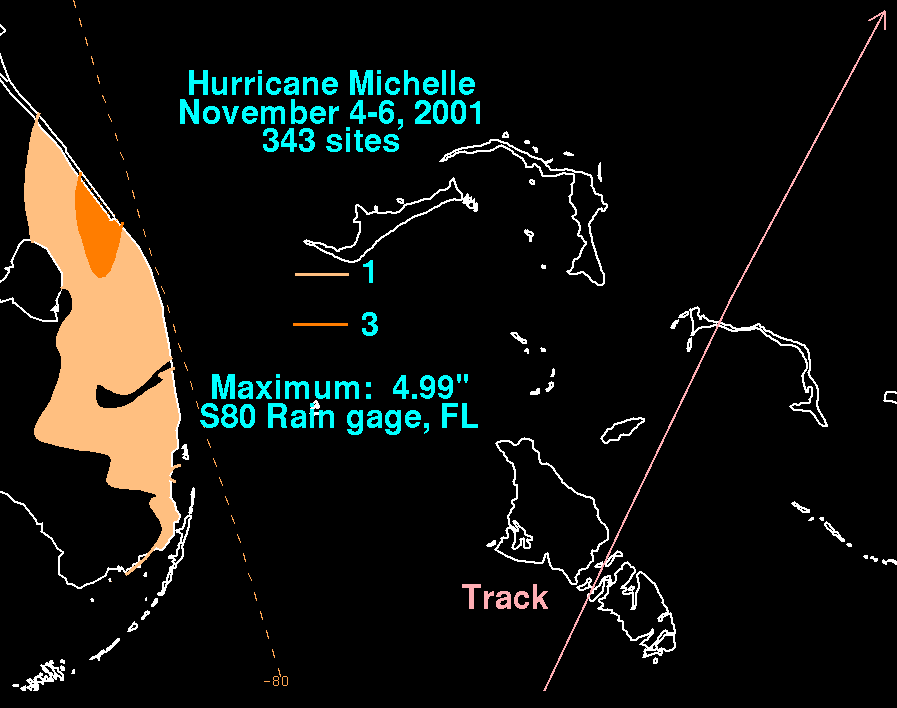
On the coast of western and southern Cuba, Michelle produced 4–5 foot waves, along with a heavy storm surge. Rainfall amounts up to 754 mm/29.69 inches were recorded across the island. In addition, 300 mm/11.83 inches was reported at Punta del Este. The provinces of Matanzas
Matanzas
Matanzas is the capital of the Cuban province of Matanzas. It is famed for its poets, culture, and Afro-Cuban folklore.It is located on the northern shore of the island of Cuba, on the Bay of Matanzas , east of the capital Havana and west of the resort town of Varadero.Matanzas is called the...
, Villa Clara
Villa Clara Province
Villa Clara is one of the provinces of Cuba. It is located in the central region of the island bordering with the Atlantic at north, Matanzas Province by west, Sancti Spiritus by east, and Cienfuegos on the South. Villa Clara shares with Cienfuegos and Sancti Spiritus on the south the Escambray...
, and Cienfuegos
Cienfuegos
Cienfuegos is a city on the southern coast of Cuba, capital of Cienfuegos Province. It is located about from Havana, and has a population of 150,000. The city is dubbed La Perla del Sur...
were hardest hit, where 10,000 homes were destroyed and another 100,000 damaged. Severe damage was also reported to the sugar cane and in the tourist town of Varadero
Varadero
Varadero is a resort town in the province of Matanzas, Cuba, and one of the largest resort areas in the Caribbean. Varadero is also called Playa Azul, which means "blue beach" in Spanish.-Geography:...
. In Havana
Havana
Havana is the capital city, province, major port, and leading commercial centre of Cuba. The city proper has a population of 2.1 million inhabitants, and it spans a total of — making it the largest city in the Caribbean region, and the most populous...
, winds and rain destroyed 23 buildings, with many others damaged. Due to well-executed warnings and evacuations, only 5 people were killed in Cuba. The Category 4 hurricane caused US$1.8 billion in damage.
The United States
United States
The United States of America is a federal constitutional republic comprising fifty states and a federal district...
offered aid to the island, an act it had done in the past despite a political embargo. President Fidel Castro
Fidel Castro
Fidel Alejandro Castro Ruz is a Cuban revolutionary and politician, having held the position of Prime Minister of Cuba from 1959 to 1976, and then President from 1976 to 2008. He also served as the First Secretary of the Communist Party of Cuba from the party's foundation in 1961 until 2011...
refused, believing his country would survive with enough resources for the reconstruction process.
Florida
Storm surge
A storm surge is an offshore rise of water associated with a low pressure weather system, typically tropical cyclones and strong extratropical cyclones. Storm surges are caused primarily by high winds pushing on the ocean's surface. The wind causes the water to pile up higher than the ordinary sea...
of 1 to 2 ft (0.3048 to 0.6096 m) was recorded along the southeast coastline of Florida. Damages from the hurricane amounted to $50,000.
Two tornadoes touched down in the state within the outer bands
Rainband
A rainband is a cloud and precipitation structure associated with an area of rainfall which is significantly elongated. Rainbands can be stratiform or convective, and are generated by differences in temperature. When noted on weather radar imagery, this precipitation elongation is referred to as...
of the hurricane. The first formed as a waterspout
Waterspout
A waterspout is an intense columnar vortex that occurs over a body of water and is connected to a cumuliform cloud. In the common form, it is a non-supercell tornado over water. While it is often weaker than most of its land counterparts, stronger versions spawned by mesocyclones do occur...
and moved onshore near Bill Baggs Beach and destroyed two Chikee huts, costing $6,000, warranting F0 intensity, before dissipating. The second and stronger of the two tornadoes, rated F1, tracked for 2 mi (3.2 km) in Palm Beach County
Palm Beach County, Florida
Palm Beach County is the largest county in the state of Florida in total area, and third in population. As of 2010, the county's estimated population was 1,320,134, making it the twenty-eighth most populous in the United States...
. Windows were blown out of vehicles and buildings, trees and signs were downed and a small area of sugar cane was leveled by the tornado. Damages from the tornado amounted to $10,000. A NOAA
National Oceanic and Atmospheric Administration
The National Oceanic and Atmospheric Administration , pronounced , like "noah", is a scientific agency within the United States Department of Commerce focused on the conditions of the oceans and the atmosphere...
WP-3D Orion
WP-3D Orion
|-See also:- External links:* *...
hurricane hunter
Hurricane Hunters
The Hurricane Hunters are aircraft that fly into tropical cyclones in the North Atlantic Ocean and Northeastern Pacific Ocean for the specific purpose of directly measuring weather data in and around those storms. In the United States, the Air Force, Navy, and NOAA units have all participated in...
aircraft was damaged during a mission into the storm.
Bahamas
Because Hurricane Michelle was weakened and moving rapidly as it moved through the Bahamas, no deaths or damage were reported. The hurricane still retained some of its strength, and caused 12.64 inches (321.1 mm) of rain in NassauNassau, Bahamas
Nassau is the capital, largest city, and commercial centre of the Commonwealth of the Bahamas. The city has a population of 248,948 , 70 percent of the entire population of The Bahamas...
, while New Providence
New Providence
New Providence is the most populous island in the Bahamas, containing more than 70% of the total population. It also houses the national capital city, Nassau.The island was originally under Spanish control following Christopher Columbus' discovery of the New World, but the Spanish government showed...
received a storm surge of 5–8 feet. Flooding was reported throughout the archipelago and high winds downed numerous trees, resulting in 200,000 power outages. A few homes sustained roof damage and the roof a shopping center in Nassau was blown into a nearby funeral home. The radio tower of the station MORE FM was snapped in half by high winds, resulting in a severe disruption of radio broadcasts.
Aftermath
Ships carrying tons of frozen chicken legs and corn arrived in Havana's harbor on December 16, to aid in the recovery of Cuba from Hurricane Michelle. The shipments are part of a one-time $30 million purchase of U.S. food by the Cuban government to assist in the country's present food shortage.The Cuban government refused an initial U.S. offer of humanitarian assistance, but accepted a proposal to purchase the goods instead. Although the United States has maintained an economic embargo on Cuba for decades, U.S. law does allow shipments of food and medicine to the communist-controlled island. But until now the Cuban government has refused to buy American food because of the restrictions, including a ban on direct U.S. financing of food sales.
Other aid from the international community is helping Cuba survive Michelle's aftermath. Cuba was promised $600,000 in aid from Chinese leader Li Peng, who was visiting when the hurricane struck. Venezuela also sent humanitarian assistance.
Retirement
Because of its effects, the name Michelle was retired in the spring of 2002 and will never again be used for an Atlantic hurricane. The name was replaced with Melissa in the 2007 season2007 Atlantic hurricane season
The 2007 Atlantic hurricane season was an active Atlantic hurricane season that produced 17 tropical cyclones, 15 tropical storms, six hurricanes, and two major hurricanes. It officially started on June 1 and ended on November 30, dates which conventionally delimit the...
.
See also
- List of wettest tropical cyclones in Cuba since 1963
- List of retired Atlantic hurricane names
- List of Florida hurricanes (2000–present)
- List of Category 4 Atlantic hurricanes