
.gif)
Tropical Storm Erin (2007)
Encyclopedia
Tropical Storm Erin was the second tropical cyclone
to make landfall
in the United States
in the 2007 Atlantic hurricane season
. The fifth named storm of the season, it formed in the Gulf of Mexico
on August 14 from a persistent area of convection. It attained tropical storm status the next day, and on August 16 Erin made landfall near Lamar, Texas
, and persisted over land across Texas
before moving northward into Oklahoma
. The storm resulted in at least 16 fatalities and worsened an already-severe flooding issue in Texas.
developed just south of Jamaica
in association with a trough
of low pressure. The system tracked west-northwestward, and by August 10 consisted of a broad surface trough with minimal shower activity. Convection increased on August 11, and by August 12 the interaction between a tropical wave
and an upper-level low in the area resulted in a large area of disorganized thunderstorms extending from the western Caribbean Sea
into the central Bahamas. Upper-level winds gradually became more beneficial for development, and on August 13 a broad low pressure area
formed about 90 miles (145 km) north-northeast of Cancún
, Quintana Roo
. Late on August 14, a Hurricane Hunters
flight into the system reported a small circulation center, but at the time was not well-defined enough to result in the initiation of tropical cyclone advisories. However, deep convection was maintained near the increasingly organizing center, and at 0300 UTC on August 15 the National Hurricane Center
classified it as Tropical Depression Five about 425 miles (685 km) southeast of Brownsville, Texas
.
In the overnight hours after formation, the storm was disorganized with a ragged and ill-defined center of circulation. Located to the south of a mid to upper-level ridge
over the southern United States
, the system tracked to the west-northwest through an environment conducive for further strengthening; an upper-level anticyclone
developed over the central Gulf of Mexico, and sea surface temperatures along its track were warm. The cloud pattern became better organized, maintaining a large area of convection with curved rainbands and well-established outflow
. Based on reports from Hurricane Hunters, the National Hurricane Center upgraded the depression to Tropical Storm Erin at 1530 UTC on August 15 about 250 miles (400 km) east of Brownsville, Texas. As it continued northwestward, Erin remained disorganized and failed to strengthen beyond minimal tropical storm status. At 1200 UTC on August 16 the cyclone made landfall
near Lamar, Texas
as it weakened to tropical depression status. Three hours later, the National Hurricane Center ceased issuing advisories on Erin as warning responsibility was transferred to the Hydrometeorological Prediction Center
.
 Drifting northwestward through Texas, Tropical Depression Erin maintained an area of convection near the center, with its widespread but scattered rainbands dropping moderate to heavy precipitation. By August 17, the winds decreased to 20 mph (30 km/h), with higher gusts. The system turned to the north-northeast on August 18, while heavy bands of thunderstorms continued to rotate around the center of Erin. Early on August 19 after entering Oklahoma
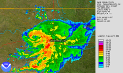
, the remnants of Erin suddenly re-intensified to maximum sustained winds of 60 mph (95 km/h) a short distance west of Oklahoma City
. The Norman, Oklahoma
National Weather Service
remarked the intensification "[resulted] in what amounts to an inland tropical storm;" at 0930 UTC the system presented an eye-like
feature and a spiral rainband, and produced wind gusts of over 80 mph (130 km/h). However, a few hours later, the depression began weakening again, and late on August 19 Erin weakened significantly as the circulation dissipated over northeastern Oklahoma. Despite displaying tropical characteristics, the National Hurricane Center determined the system was not a tropical cyclone over Oklahoma, and classified it as a "low". The low continued into southeastern Kansas
before dissipating, feeding moisture northward toward a frontal system
extending from the Midwestern United States
through the Mid-Atlantic States
. Its remnant mid-level circulation then moved eastward across Missouri, Kentucky, and Virginia before losing identity as it moved out into the Atlantic Ocean.
Immediately upon becoming a tropical cyclone, the National Hurricane Center issued a tropical storm watch
from Freeport, Texas
to the United States
/Mexico
border; at the same time, the government of Mexico issued a tropical storm watch southward to Rio San Fernando. Shortly before attaining tropical storm status, the watch in Texas was upgraded to a tropical storm warning. Late on August 15, the warning was extended to San Luis Pass
, while the watch in Mexico was discontinued. As Erin made landfall, the warning was canceled, and several flood watch
es and warnings were issued for counties across southeastern Texas. Upon moving into Oklahoma
, flood and flash flood warnings were issued for several counties.
Governor
Rick Perry
activated the National Guard and mobilized emergency personnel to the region expected to be affected by the storm. Erin was expected to bring flooding to the region, which had already been declared a disaster area
on August 7, 2007 due to widespread flooding on the Nueces River
basin; this area remained flooded as of August 15, 2007. On August 15, oil
futures
rose to $74.01 (USD), due to fears of Erin disrupting oil supplies produced on Texan coasts, combined with low oil inventories. As a result of the threat from the storm, Shell Oil Company
evacuated 188 workers on oil platforms in the northwestern Gulf of Mexico.
 By midday on August 15, rainbands
with gusty winds began affecting the Texas
coastline. As it moved ashore, the storm produced heavy rainfall near and to the or northeast of its path, reaching 11.02 inches (280 mm) at a station in Lockwood. The storm caused several bayous in the Houston
area to reach or exceed flood levels. Across southeastern Texas, the cyclone spawned several funnel cloud
s, and near IAH
an EF0
tornado was reported. Wind gusts from Erin were minor across the state, peaking at 35 mph (55 km/h) at Palacios
with an unofficial report of 39 mph (63 km/h) at Jamaica Beach
. Upon moving ashore, the storm produced a minor storm surge
peaking at 3.22 feet (0.98 m) at Pleasure Pier, which caused minor beach erosion.
In Clear Lake City
, heavy rainfall collapsed a portion of a grocery store roof, killing two workers. The precipitation caused moderate flooding across eastern portions of Harris County
; over 400 homes and 40 businesses were flooded. Flooding across the Greater Houston
area briefly halted the METRORail
and closed several state roads. One person drowned after driving into a retention pond. Several people required rescue assistance, and in Comal County
a car accident caused three fatalities. The passage of the storm temporarily left about 20,000 electrical customers without power, though most outages were quickly restored. In San Antonio
, one body was recovered from a creek and another died after driving into a flooded road and was swept into a drainage ditch in which four others survived. In Sisterdale
, two people were killed when they were swept away stalled over Sister Creek. In Taylor County
, near Abilene
, flooding killed one person and forced the evacuation of about 2,000 people. Damage in Texas totaled over $45 million (2007 USD).
, Kingfisher
and Geary
were the hardest-hit communities, where many houses and buildings were inundated. Winds in Watonga gusted as high as 82 mph (131 km/h), which damaged numerous trees and power lines and heavily damaged mobile home
s. The entire community lost power, as did about 15,000 customers in total in the Oklahoma City metropolitan area
. A section of Interstate 40
was also closed for a while.
One person drowned in a cellar in Fort Cobb
, and another drowned in Kingfisher
. Another storm-related death took place in Seminole
. Three others were found dead after a weather-related automobile accident also near Carnegie
. Another automobile accident fatality took place in Okmulgee County
but it is unclear if the event was storm-related. Damage amounted to over $2 million (2007 USD).
.
Tropical cyclone
A tropical cyclone is a storm system characterized by a large low-pressure center and numerous thunderstorms that produce strong winds and heavy rain. Tropical cyclones strengthen when water evaporated from the ocean is released as the saturated air rises, resulting in condensation of water vapor...
to make landfall
Landfall (meteorology)
Landfall is the event of a tropical cyclone or a waterspout coming onto land after being over water. When a waterspout makes landfall it is reclassified as a tornado, which can then cause damage inland...
in the United States
United States
The United States of America is a federal constitutional republic comprising fifty states and a federal district...
in the 2007 Atlantic hurricane season
2007 Atlantic hurricane season
The 2007 Atlantic hurricane season was an active Atlantic hurricane season that produced 17 tropical cyclones, 15 tropical storms, six hurricanes, and two major hurricanes. It officially started on June 1 and ended on November 30, dates which conventionally delimit the...
. The fifth named storm of the season, it formed in the Gulf of Mexico
Gulf of Mexico
The Gulf of Mexico is a partially landlocked ocean basin largely surrounded by the North American continent and the island of Cuba. It is bounded on the northeast, north and northwest by the Gulf Coast of the United States, on the southwest and south by Mexico, and on the southeast by Cuba. In...
on August 14 from a persistent area of convection. It attained tropical storm status the next day, and on August 16 Erin made landfall near Lamar, Texas
Lamar, Texas
Lamar is a small, unincorporated community in Aransas County, Texas , ten miles north of Rockport and forty miles north of Corpus Christi. The community was named for Mirabeau B. Lamar, the second president of the Republic of Texas....
, and persisted over land across Texas
Texas
Texas is the second largest U.S. state by both area and population, and the largest state by area in the contiguous United States.The name, based on the Caddo word "Tejas" meaning "friends" or "allies", was applied by the Spanish to the Caddo themselves and to the region of their settlement in...
before moving northward into Oklahoma
Oklahoma
Oklahoma is a state located in the South Central region of the United States of America. With an estimated 3,751,351 residents as of the 2010 census and a land area of 68,667 square miles , Oklahoma is the 28th most populous and 20th-largest state...
. The storm resulted in at least 16 fatalities and worsened an already-severe flooding issue in Texas.
Meteorological history
On August 9, an area of convectionConvection
Convection is the movement of molecules within fluids and rheids. It cannot take place in solids, since neither bulk current flows nor significant diffusion can take place in solids....
developed just south of Jamaica
Jamaica
Jamaica is an island nation of the Greater Antilles, in length, up to in width and 10,990 square kilometres in area. It is situated in the Caribbean Sea, about south of Cuba, and west of Hispaniola, the island harbouring the nation-states Haiti and the Dominican Republic...
in association with a trough
Trough (meteorology)
A trough is an elongated region of relatively low atmospheric pressure, often associated with fronts.Unlike fronts, there is not a universal symbol for a trough on a weather chart. The weather charts in some countries or regions mark troughs by a line. In the United States, a trough may be marked...
of low pressure. The system tracked west-northwestward, and by August 10 consisted of a broad surface trough with minimal shower activity. Convection increased on August 11, and by August 12 the interaction between a tropical wave
Tropical wave
Tropical waves, easterly waves, or tropical easterly waves, also known as African easterly waves in the Atlantic region, are a type of atmospheric trough, an elongated area of relatively low air pressure, oriented north to south, which move from east to west across the tropics causing areas of...
and an upper-level low in the area resulted in a large area of disorganized thunderstorms extending from the western Caribbean Sea
Caribbean Sea
The Caribbean Sea is a sea of the Atlantic Ocean located in the tropics of the Western hemisphere. It is bounded by Mexico and Central America to the west and southwest, to the north by the Greater Antilles, and to the east by the Lesser Antilles....
into the central Bahamas. Upper-level winds gradually became more beneficial for development, and on August 13 a broad low pressure area
Low pressure area
A low-pressure area, or "low", is a region where the atmospheric pressure at sea level is below that of surrounding locations. Low-pressure systems form under areas of wind divergence which occur in upper levels of the troposphere. The formation process of a low-pressure area is known as...
formed about 90 miles (145 km) north-northeast of Cancún
Cancún
Cancún is a city of international tourism development certified by the UNWTO . Located on the northeast coast of Quintana Roo in southern Mexico, more than 1,700 km from Mexico City, the Project began operations in 1974 as Integrally Planned Center, a pioneer of FONATUR Cancún is a city of...
, Quintana Roo
Quintana Roo
Quintana Roo officially Estado Libre y Soberano de Quintana Roo is one of the 31 states which, with the Federal District, comprise the 32 Federal Entities of Mexico. It is divided in 10 municipalities and its capital city is Chetumal....
. Late on August 14, a Hurricane Hunters
Hurricane Hunters
The Hurricane Hunters are aircraft that fly into tropical cyclones in the North Atlantic Ocean and Northeastern Pacific Ocean for the specific purpose of directly measuring weather data in and around those storms. In the United States, the Air Force, Navy, and NOAA units have all participated in...
flight into the system reported a small circulation center, but at the time was not well-defined enough to result in the initiation of tropical cyclone advisories. However, deep convection was maintained near the increasingly organizing center, and at 0300 UTC on August 15 the National Hurricane Center
National Hurricane Center
The National Hurricane Center , located at Florida International University in Miami, Florida, is the division of the National Weather Service responsible for tracking and predicting weather systems within the tropics between the Prime Meridian and the 140th meridian west poleward to the 30th...
classified it as Tropical Depression Five about 425 miles (685 km) southeast of Brownsville, Texas
Brownsville, Texas
Brownsville is a city in the southernmost tip of the state of Texas, in the United States. It is located on the northern bank of the Rio Grande, directly north and across the border from Matamoros, Tamaulipas, Mexico. Brownsville is the 16th largest city in the state of Texas with a population of...
.
In the overnight hours after formation, the storm was disorganized with a ragged and ill-defined center of circulation. Located to the south of a mid to upper-level ridge
Ridge (meteorology)
A ridge is an elongated region of relatively high atmospheric pressure, the opposite of a trough....
over the southern United States
United States
The United States of America is a federal constitutional republic comprising fifty states and a federal district...
, the system tracked to the west-northwest through an environment conducive for further strengthening; an upper-level anticyclone
Anticyclone
An anticyclone is a weather phenomenon defined by the United States' National Weather Service's glossary as "[a] large-scale circulation of winds around a central region of high atmospheric pressure, clockwise in the Northern Hemisphere, counterclockwise in the Southern Hemisphere"...
developed over the central Gulf of Mexico, and sea surface temperatures along its track were warm. The cloud pattern became better organized, maintaining a large area of convection with curved rainbands and well-established outflow
Outflow (meteorology)
Outflow, in meteorology, is air that flows outwards from a storm system. It is associated with ridging, or anticyclonic flow. In the low levels of the troposphere, outflow radiates from thunderstorms in the form of a wedge of rain-cooled air, which is visible as a thin rope-like cloud on weather...
. Based on reports from Hurricane Hunters, the National Hurricane Center upgraded the depression to Tropical Storm Erin at 1530 UTC on August 15 about 250 miles (400 km) east of Brownsville, Texas. As it continued northwestward, Erin remained disorganized and failed to strengthen beyond minimal tropical storm status. At 1200 UTC on August 16 the cyclone made landfall
Landfall (meteorology)
Landfall is the event of a tropical cyclone or a waterspout coming onto land after being over water. When a waterspout makes landfall it is reclassified as a tornado, which can then cause damage inland...
near Lamar, Texas
Lamar, Texas
Lamar is a small, unincorporated community in Aransas County, Texas , ten miles north of Rockport and forty miles north of Corpus Christi. The community was named for Mirabeau B. Lamar, the second president of the Republic of Texas....
as it weakened to tropical depression status. Three hours later, the National Hurricane Center ceased issuing advisories on Erin as warning responsibility was transferred to the Hydrometeorological Prediction Center
Hydrometeorological Prediction Center
The Hydrometeorological Prediction Center is one of nine service centers under the umbrella of the National Centers for Environmental Prediction , a part of the National Weather Service, which in turn is part of the National Oceanic and Atmospheric Administration of the U.S. government...
.
Oklahoma
Oklahoma is a state located in the South Central region of the United States of America. With an estimated 3,751,351 residents as of the 2010 census and a land area of 68,667 square miles , Oklahoma is the 28th most populous and 20th-largest state...
, the remnants of Erin suddenly re-intensified to maximum sustained winds of 60 mph (95 km/h) a short distance west of Oklahoma City
Oklahoma City, Oklahoma
Oklahoma City is the capital and the largest city in the state of Oklahoma. The county seat of Oklahoma County, the city ranks 31st among United States cities in population. The city's population, from the 2010 census, was 579,999, with a metro-area population of 1,252,987 . In 2010, the Oklahoma...
. The Norman, Oklahoma
Norman, Oklahoma
Norman is a city in Cleveland County, Oklahoma, United States, and is located south of downtown Oklahoma City. It is part of the Oklahoma City metropolitan area. As of the 2010 census, Norman was to have 110,925 full-time residents, making it the third-largest city in Oklahoma and the...
National Weather Service
National Weather Service
The National Weather Service , once known as the Weather Bureau, is one of the six scientific agencies that make up the National Oceanic and Atmospheric Administration of the United States government...
remarked the intensification "[resulted] in what amounts to an inland tropical storm;" at 0930 UTC the system presented an eye-like
Eye (cyclone)
The eye is a region of mostly calm weather found at the center of strong tropical cyclones. The eye of a storm is a roughly circular area and typically 30–65 km in diameter. It is surrounded by the eyewall, a ring of towering thunderstorms where the second most severe weather of a cyclone...
feature and a spiral rainband, and produced wind gusts of over 80 mph (130 km/h). However, a few hours later, the depression began weakening again, and late on August 19 Erin weakened significantly as the circulation dissipated over northeastern Oklahoma. Despite displaying tropical characteristics, the National Hurricane Center determined the system was not a tropical cyclone over Oklahoma, and classified it as a "low". The low continued into southeastern Kansas
Kansas
Kansas is a US state located in the Midwestern United States. It is named after the Kansas River which flows through it, which in turn was named after the Kansa Native American tribe, which inhabited the area. The tribe's name is often said to mean "people of the wind" or "people of the south...
before dissipating, feeding moisture northward toward a frontal system
Cold front
A cold front is defined as the leading edge of a cooler mass of air, replacing a warmer mass of air.-Development of cold front:The cooler and denser air wedges under the less-dense warmer air, lifting it...
extending from the Midwestern United States
Midwestern United States
The Midwestern United States is one of the four U.S. geographic regions defined by the United States Census Bureau, providing an official definition of the American Midwest....
through the Mid-Atlantic States
Mid-Atlantic States
The Mid-Atlantic states, also called middle Atlantic states or simply the mid Atlantic, form a region of the United States generally located between New England and the South...
. Its remnant mid-level circulation then moved eastward across Missouri, Kentucky, and Virginia before losing identity as it moved out into the Atlantic Ocean.
Preparations
| Weather alerts as Tropical Storm Erin made landfall in Texas | |||
|---|---|---|---|
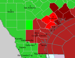 |
|||
| Tornado Warning Tornado warning A tornado warning is an alert issued by government weather services to warn that severe thunderstorms with tornadoes may be imminent. It can be issued after a tornado or funnel cloud has been spotted by eye, or more commonly if there are radar indications of tornado formation... |
Flash Flood Warning Flash Flood Warning A Flash Flood Warning is issued when a flash flood is imminent or occurring in the warned area. A flash flood is a sudden, violent flood after a heavy rain... |
||
| Inland Tropical Storm Warning | Tropical Storm Warning | ||
| Flood Warning | Flash Flood Watch | ||
| Small Craft Advisory | |||
Immediately upon becoming a tropical cyclone, the National Hurricane Center issued a tropical storm watch
Tropical cyclone warnings and watches
Warnings and watches are two levels of alert issued by national weather forecasting bodies to coastal areas threatened by the imminent approach of a tropical cyclone of tropical storm or hurricane intensity. They are notices to the local population and civil authorities to make appropriate...
from Freeport, Texas
Freeport, Texas
Freeport is a city in Brazoria County, Texas within the Houston–Sugar Land–Baytown metropolitan area and is situated in Southeast Texas. As of the 2000 U.S...
to the United States
United States
The United States of America is a federal constitutional republic comprising fifty states and a federal district...
/Mexico
Mexico
The United Mexican States , commonly known as Mexico , is a federal constitutional republic in North America. It is bordered on the north by the United States; on the south and west by the Pacific Ocean; on the southeast by Guatemala, Belize, and the Caribbean Sea; and on the east by the Gulf of...
border; at the same time, the government of Mexico issued a tropical storm watch southward to Rio San Fernando. Shortly before attaining tropical storm status, the watch in Texas was upgraded to a tropical storm warning. Late on August 15, the warning was extended to San Luis Pass
San Luis Pass
San Luis Pass is a strait of water at the south-western end of Galveston Island off the shores of the U.S. state of Texas. It connects the sheltered waters of West Bay to the open Gulf of Mexico.-Fishing:...
, while the watch in Mexico was discontinued. As Erin made landfall, the warning was canceled, and several flood watch
Flood watch
Flood alerts are issued by weather agencies to alert residents that flood conditions are a possibility for their area.-Types of flood alerts:...
es and warnings were issued for counties across southeastern Texas. Upon moving into Oklahoma
Oklahoma
Oklahoma is a state located in the South Central region of the United States of America. With an estimated 3,751,351 residents as of the 2010 census and a land area of 68,667 square miles , Oklahoma is the 28th most populous and 20th-largest state...
, flood and flash flood warnings were issued for several counties.
Governor
Governor of Texas
The governor of Texas is the head of the executive branch of Texas's government and the commander-in-chief of the state's military forces. The governor has the power to either approve or veto bills passed by the Texas Legislature, and to convene the legislature...
Rick Perry
Rick Perry
James Richard "Rick" Perry is the 47th and current Governor of Texas. A Republican, Perry was elected Lieutenant Governor of Texas in 1998 and assumed the governorship in December 2000 when then-governor George W. Bush resigned to become President of the United States. Perry was elected to full...
activated the National Guard and mobilized emergency personnel to the region expected to be affected by the storm. Erin was expected to bring flooding to the region, which had already been declared a disaster area
Disaster area
A disaster area is a region or a locale heavily damaged by either natural hazards, such as tornadoes, hurricanes, tsunamis, floods, earthquakes, technological hazards including nuclear and radiation accidents, or sociological hazards like riots, terrorism or war. The population living there often...
on August 7, 2007 due to widespread flooding on the Nueces River
Nueces River
The Nueces River is a river in the U.S. state of Texas, approximately long. It drains a region in central and southern Texas southeastward into the Gulf of Mexico. It is the southernmost major river in Texas northeast of the Rio Grande...
basin; this area remained flooded as of August 15, 2007. On August 15, oil
Oil
An oil is any substance that is liquid at ambient temperatures and does not mix with water but may mix with other oils and organic solvents. This general definition includes vegetable oils, volatile essential oils, petrochemical oils, and synthetic oils....
futures
Futures contract
In finance, a futures contract is a standardized contract between two parties to exchange a specified asset of standardized quantity and quality for a price agreed today with delivery occurring at a specified future date, the delivery date. The contracts are traded on a futures exchange...
rose to $74.01 (USD), due to fears of Erin disrupting oil supplies produced on Texan coasts, combined with low oil inventories. As a result of the threat from the storm, Shell Oil Company
Shell Oil Company
Shell Oil Company is the United States-based subsidiary of Royal Dutch Shell, a multinational oil company of Anglo Dutch origins, which is amongst the largest oil companies in the world. Approximately 22,000 Shell employees are based in the U.S. The head office in the U.S. is in Houston, Texas...
evacuated 188 workers on oil platforms in the northwestern Gulf of Mexico.
Texas
Squall
A squall is a sudden, sharp increase in wind speed which is usually associated with active weather, such as rain showers, thunderstorms, or heavy snow. Squalls refer to an increase in the sustained winds over a short time interval, as there may be higher gusts during a squall event...
with gusty winds began affecting the Texas
Texas
Texas is the second largest U.S. state by both area and population, and the largest state by area in the contiguous United States.The name, based on the Caddo word "Tejas" meaning "friends" or "allies", was applied by the Spanish to the Caddo themselves and to the region of their settlement in...
coastline. As it moved ashore, the storm produced heavy rainfall near and to the or northeast of its path, reaching 11.02 inches (280 mm) at a station in Lockwood. The storm caused several bayous in the Houston
Houston, Texas
Houston is the fourth-largest city in the United States, and the largest city in the state of Texas. According to the 2010 U.S. Census, the city had a population of 2.1 million people within an area of . Houston is the seat of Harris County and the economic center of , which is the ...
area to reach or exceed flood levels. Across southeastern Texas, the cyclone spawned several funnel cloud
Funnel cloud
A funnel cloud is a funnel-shaped cloud of condensed water droplets, associated with a rotating column of wind and extending from the base of a cloud but not reaching the ground or a water surface. A funnel cloud is usually visible as a cone-shaped or needle like protuberance from the main cloud...
s, and near IAH
George Bush Intercontinental Airport
George Bush Intercontinental Airport, is a Class B international airport in Houston, Texas, serving the Houston–Sugar Land–Baytown metropolitan area, the sixth-largest metropolitan area in the United States. Located north of Downtown Houston between Interstate 45 and U.S. Highway 59...
an EF0
Enhanced Fujita Scale
The Enhanced Fujita Scale rates the strength of tornadoes in the United States based on the damage they cause.Implemented in place of the Fujita scale introduced in 1971 by Ted Fujita, it began operational use on February 1, 2007. The scale has the same basic design as the original Fujita scale:...
tornado was reported. Wind gusts from Erin were minor across the state, peaking at 35 mph (55 km/h) at Palacios
Palacios, Texas
-Demographics:As of the census of 2000, there were 5,153 people, 1,661 households, and 1,244 families residing in the city. The population density was 1,021.4 people per square mile . There were 1,976 housing units at an average density of 391.7 per square mile...
with an unofficial report of 39 mph (63 km/h) at Jamaica Beach
Jamaica Beach, Texas
Jamaica Beach is a city in Galveston County, Texas, United States. As of the 2000 census, the city population was 1,075.-History:Prior to its development, Jamaica Beach was a Karankawa burial ground. Johnny Goyen and Earl Galceran of the Jamaica Corporation developed Jamaica Beach as a 2,000-lot...
. Upon moving ashore, the storm produced a minor storm surge
Storm surge
A storm surge is an offshore rise of water associated with a low pressure weather system, typically tropical cyclones and strong extratropical cyclones. Storm surges are caused primarily by high winds pushing on the ocean's surface. The wind causes the water to pile up higher than the ordinary sea...
peaking at 3.22 feet (0.98 m) at Pleasure Pier, which caused minor beach erosion.
In Clear Lake City
Clear Lake City, Houston, Texas
Clear Lake City is a master-planned community located in southeast Harris County, Texas, within the Bay Area of Greater Houston. It is the second-largest master-planned community in Houston — behind Kingwood...
, heavy rainfall collapsed a portion of a grocery store roof, killing two workers. The precipitation caused moderate flooding across eastern portions of Harris County
Harris County, Texas
As of the 2010 Census, the population of the county was 4,092,459, White Americans made up 56.6% of Harris County's population; non-Hispanic whites represented 33.0% of the population. Black Americans made up 18.9% of the population. Native Americans made up 0.7% of Harris County's population...
; over 400 homes and 40 businesses were flooded. Flooding across the Greater Houston
Greater Houston
Houston–Sugar Land–Baytown is a 10-county metropolitan area defined by the Office of Management and Budget. It is located along the Gulf Coast region in the U.S. state of Texas...
area briefly halted the METRORail
METRORail
METRORail is the light rail line in Houston . It is the second major light rail service in Texas following the Dallas Area Rapid Transit system. With an approximate daily ridership of 34,155, the METRORail ranks as the fourteenth most-traveled light rail system in the United States, with the...
and closed several state roads. One person drowned after driving into a retention pond. Several people required rescue assistance, and in Comal County
Comal County, Texas
Comal County is a county located on the Edwards Plateau in the U.S. state of Texas. In 2010, its population was 108,472. Its seat is New Braunfels.Comal County is part of the San Antonio Metropolitan Statistical Area.-History Timeline:...
a car accident caused three fatalities. The passage of the storm temporarily left about 20,000 electrical customers without power, though most outages were quickly restored. In San Antonio
San Antonio, Texas
San Antonio is the seventh-largest city in the United States of America and the second-largest city within the state of Texas, with a population of 1.33 million. Located in the American Southwest and the south–central part of Texas, the city serves as the seat of Bexar County. In 2011,...
, one body was recovered from a creek and another died after driving into a flooded road and was swept into a drainage ditch in which four others survived. In Sisterdale
Sisterdale, Texas
Sisterdale, Texas, is an unincorporated farming and ranching community, established in 1847 and located north of Boerne in Kendall County, in the U.S. state of Texas. The community is located in the valley of Sister Creek. The current 2010 population is 25...
, two people were killed when they were swept away stalled over Sister Creek. In Taylor County
Taylor County, Texas
As of the census of 2000, there were 126,555 people, 47,274 households, and 32,524 families residing in the county. The population density was 138 people per square mile . There were 52,056 housing units at an average density of 57 per square mile...
, near Abilene
Abilene, Texas
Abilene is a city in Taylor and Jones counties in west central Texas. The population was 117,063 at the 2010 census. It is the principal city of the Abilene Metropolitan Statistical Area, which had a 2006 estimated population of 158,063. It is the county seat of Taylor County...
, flooding killed one person and forced the evacuation of about 2,000 people. Damage in Texas totaled over $45 million (2007 USD).
Oklahoma
After its unexpected redevelopment over Oklahoma, widespread damage was also reported there. Several communities in central Oklahoma were flooded due to the heavy rainfall. WatongaWatonga, Oklahoma
Watonga is a city in Blaine County, Oklahoma, United States. The population was 4,658 at the 2000 census. It is the county seat of Blaine County.-Early History:...
, Kingfisher
Kingfisher, Oklahoma
Kingfisher is a city in and the county seat of Kingfisher County, Oklahoma, United States. The population was 4,380 at the 2000 census. It is the former home and namesake of Kingfisher College.-History:...
and Geary
Geary, Oklahoma
Geary is a city in Blaine and Canadian counties in the U.S. state of Oklahoma. The population was 1,280 at the 2010 census.-Geography:Geary is located at ....
were the hardest-hit communities, where many houses and buildings were inundated. Winds in Watonga gusted as high as 82 mph (131 km/h), which damaged numerous trees and power lines and heavily damaged mobile home
Mobile home
Mobile homes or static caravans are prefabricated homes built in factories, rather than on site, and then taken to the place where they will be occupied...
s. The entire community lost power, as did about 15,000 customers in total in the Oklahoma City metropolitan area
Oklahoma City metropolitan area
-Metro-area suburbs and exurbs:The following communities are suburbs and exurbs of Oklahoma City with populations of at least 1,000 found within the bounds of State Highway 33 to the north, State Highway 18 and US-177 to the east, State Highway 39 and State Highway 9 to the south, and US-81 to the...
. A section of Interstate 40
Interstate 40
Interstate 40 is the third-longest major east–west Interstate Highway in the United States, after I-90 and I-80. Its western end is at Interstate 15 in Barstow, California; its eastern end is at a concurrency of U.S. Route 117 and North Carolina Highway 132 in Wilmington, North Carolina...
was also closed for a while.
One person drowned in a cellar in Fort Cobb
Fort Cobb, Oklahoma
Fort Cobb is a town in Caddo County, Oklahoma, United States. The population was 667 at the 2000 census.-Geography:Fort Cobb is located at ....
, and another drowned in Kingfisher
Kingfisher, Oklahoma
Kingfisher is a city in and the county seat of Kingfisher County, Oklahoma, United States. The population was 4,380 at the 2000 census. It is the former home and namesake of Kingfisher College.-History:...
. Another storm-related death took place in Seminole
Seminole, Oklahoma
Seminole is a city in Seminole County, Oklahoma, United States. The population was 6,899 at the 2000 census. Seminole experienced a large population growth in the 1920s due to an oil boom...
. Three others were found dead after a weather-related automobile accident also near Carnegie
Carnegie, Oklahoma
Carnegie is a town in Caddo County, Oklahoma, United States. The population was 1,723 at the 2010 census.-Geography:Carnegie is located at .According to the United States Census Bureau, the town has a total area of , all of it land....
. Another automobile accident fatality took place in Okmulgee County
Okmulgee County, Oklahoma
Okmulgee County is a county located in the U.S. state of Oklahoma. As of 2000, the population was 39,685. Its county seat is Okmulgee.-Geography:According to the U.S. Census Bureau, the county has a total area of 1,819 km²...
but it is unclear if the event was storm-related. Damage amounted to over $2 million (2007 USD).
Missouri
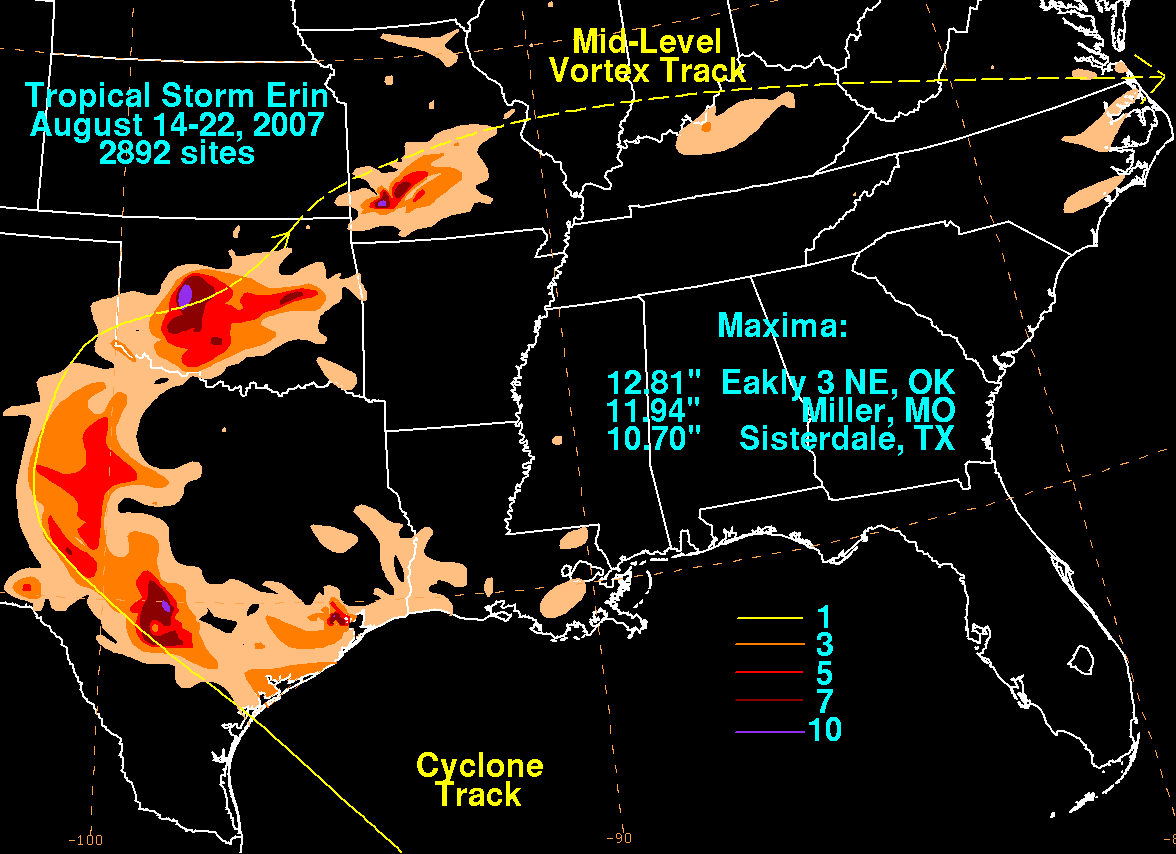
Although its surface circulation had dissipated, its circulation aloft remained intact and led to a burst of rainfall early on August 20. The 11.94 inches/303.3 mm that fell at Miller became the wettest Missouri rainfall total associated with a tropical cyclone, or its remains, since at least 1972. One person died in Sleeper when he drove into flood waters which had swept away a bridge he was attempting to navigate onto. Nine water rescues occurred along the I-44 corridor, mostly caused by Erin's rainfall. Damage totaled about $19.8 million (2007 USD) in the state, primarily in Polk CountyPolk County, Missouri
Polk County is a county located in the U.S. state of Missouri. As of 2010, the population was 31,137. Its county seat is Bolivar.Polk County is part of the Springfield, Missouri, Metropolitan Statistical Area.- History :...
.
See also
- 2007 Midwest flooding2007 Midwest floodingThe 2007 Midwest flooding was a major flooding event that occurred in the Midwestern United States in the third week of August 2007. While Hurricane Dean was affecting the Yucatán Peninsula and the Gulf of Mexico, and Tropical Storm Erin was affecting Oklahoma and Texas, a persistent storm system...
- Landphoon
- Other storms of the same nameHurricane ErinThe name Erin has been used for four tropical cyclones in the Atlantic Ocean:* Hurricane Erin * Hurricane Erin * Hurricane Erin * Tropical Storm Erin...
- Timeline of the 2007 Atlantic hurricane seasonTimeline of the 2007 Atlantic hurricane seasonThis timeline documents all the storm formations, strengthening, weakening, landfalls, extratropical transitions, as well as dissipation during the 2007 Atlantic hurricane season. The season officially began on June 1, 2007, and ended on November 30, although Subtropical Storm Andrea and Tropical...
External links
- See the NHC advisory archive on Tropical Storm Erin
- See the HPC advisory archive on Tropical Depression Erin