
.gif)
Tropical Storm Ana (2003)
Encyclopedia
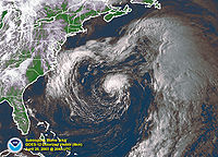
Tropical Storm Ana was the only tropical cyclone
on record in the Atlantic basin
to form during the month of April. The first tropical cyclone of the season, it developed as a subtropical cyclone
from a non-tropical low
on April 20 to the west of Bermuda
. It tracked east-southeastward and organized, and on April 21 it transitioned into a tropical cyclone with peak winds of 60 mph (95 km/h). Tropical Storm Ana turned east-northeastward, steadily weakening due to wind shear and an approaching cold front
, and on April 24 it became an extratropical cyclone
. The storm brushed Bermuda with light rain, and the remnants produced precipitation in the Azores
and the United Kingdom
. Swells generated by the storm capsized a boat along the Florida
coastline, causing two fatalities.
developed about 240 miles (390 km) south-southwest of Bermuda
on April 18 through the interaction of an upper-level trough
and a surface frontal trough
. The surface trough, which extended from the gale center to Hispaniola
, brought a plume of moisture northward from the Caribbean Sea
into the circulation, which caused heavy rainfall in Puerto Rico
. The non-tropical low tracked generally northward, with a ridge
to its east and west, and on April 19 the system began producing sporadic convection near its center; early that day, satellite imagery indicated the presence of a tight inner core of winds. After turning to the northwest, it looped southeastward and gradually became separated from the surface frontal system, due to the deepening of the upper-level trough over the system. Convection became better organized over the center, and it is estimated the system developed into Subtropical Storm Ana early on April 20 while located about 250 miles (400 km) west of Bermuda. Operationally, the subtropical cyclone
was not classified by the National Hurricane Center
until 21 hours later.
The subtropical storm tracked east-southeastward and continued to organize, and by late on April 20 an upper-level warm core was present over the system. Based on its organization, Ana is estimated to have become a tropical storm by 0000 UTC
on April 21. Upon becoming a tropical storm, Ana attained a peak intensity of 60 mph (95 km/h), which was based on estimates from the Hebert-Poteat technique and data from QuikSCAT
. Shortly thereafter, it made its closest point of approach to Bermuda, when it passed about 130 miles (210 km) southwest of the island. Operationally, the cyclone was first classified by the National Hurricane Center around this time, when it was considered a subtropical cyclone. Strong upper-level wind shear
removed much of the convection, though a small area of thunderstorms persisted near the center. The storm became completely separated from the upper-level system, and the cyclone re-organized, developing an eye feature
late on April 21. Embedded within the flow of a cyclone to its north, Ana continued eastward, and early on April 22 the wind shear again removed the convection from the center. Convection waxed and waned throughout the day, and by April 23 the circulation had deteriorated in organization. After turning to the northeast, the circulation center merged with an approaching cold front
on April 24, and Tropical Storm Ana completed the transition into an extratropical cyclone
. The extratropical storm accelerated east-northeastward before losing its identity within the frontal zone on April 27 southeast of the Azores
.
 Prior to the development of Ana, the government of Bermuda
issued a gale warning for the island. Upon its classification by the National Hurricane Center, a tropical storm warning
was issued for Bermuda. Meandering near the island for several days while developing, the storm dropped 2.63 inches (67 mm) of precipitation in a six-day period at the Bermuda International Airport
. Winds on the island did not reach tropical storm force. Swells from the storm impacted the coast of Florida
. The combination of the swells and an outgoing tide caused a boat to capsize in Jupiter Inlet
on April 20; two of its occupants drowned, and the other two were rescued. As an extratropical storm, the remnants of Ana dropped 0.87 inches (22 mm) of precipitation in the city of Ponta Delgada
in the Azores
. Moisture from the remnants of Ana also produced beneficial rainfall in the United Kingdom
. Two ships recorded tropical storm force winds in association with Ana; the Atlantic Forest recorded 51 mph (82 km/h) and a pressure of 998 mbar on April 22, and the Rosa Delmas reported winds of 47 mph (76 km/h) on April 23.
On April 20, Ana became the second subtropical cyclone
on record in the Atlantic basin in the month of April, after a subtropical storm in 1992. After attaining tropical characteristics, it became the first tropical storm on record in the month of April.
Tropical cyclone
A tropical cyclone is a storm system characterized by a large low-pressure center and numerous thunderstorms that produce strong winds and heavy rain. Tropical cyclones strengthen when water evaporated from the ocean is released as the saturated air rises, resulting in condensation of water vapor...
on record in the Atlantic basin
Atlantic Ocean
The Atlantic Ocean is the second-largest of the world's oceanic divisions. With a total area of about , it covers approximately 20% of the Earth's surface and about 26% of its water surface area...
to form during the month of April. The first tropical cyclone of the season, it developed as a subtropical cyclone
Subtropical cyclone
A subtropical cyclone is a weather system that has some characteristics of a tropical and an extratropical cyclone. As early as the 1950s, meteorologists were unclear whether they should be characterized as tropical or extratropical cyclones. They were officially recognized by the National...
from a non-tropical low
Low pressure area
A low-pressure area, or "low", is a region where the atmospheric pressure at sea level is below that of surrounding locations. Low-pressure systems form under areas of wind divergence which occur in upper levels of the troposphere. The formation process of a low-pressure area is known as...
on April 20 to the west of Bermuda
Bermuda
Bermuda is a British overseas territory in the North Atlantic Ocean. Located off the east coast of the United States, its nearest landmass is Cape Hatteras, North Carolina, about to the west-northwest. It is about south of Halifax, Nova Scotia, Canada, and northeast of Miami, Florida...
. It tracked east-southeastward and organized, and on April 21 it transitioned into a tropical cyclone with peak winds of 60 mph (95 km/h). Tropical Storm Ana turned east-northeastward, steadily weakening due to wind shear and an approaching cold front
Cold front
A cold front is defined as the leading edge of a cooler mass of air, replacing a warmer mass of air.-Development of cold front:The cooler and denser air wedges under the less-dense warmer air, lifting it...
, and on April 24 it became an extratropical cyclone
Extratropical cyclone
Extratropical cyclones, sometimes called mid-latitude cyclones or wave cyclones, are a group of cyclones defined as synoptic scale low pressure weather systems that occur in the middle latitudes of the Earth having neither tropical nor polar characteristics, and are connected with fronts and...
. The storm brushed Bermuda with light rain, and the remnants produced precipitation in the Azores
Azores
The Archipelago of the Azores is composed of nine volcanic islands situated in the middle of the North Atlantic Ocean, and is located about west from Lisbon and about east from the east coast of North America. The islands, and their economic exclusion zone, form the Autonomous Region of the...
and the United Kingdom
United Kingdom
The United Kingdom of Great Britain and Northern IrelandIn the United Kingdom and Dependencies, other languages have been officially recognised as legitimate autochthonous languages under the European Charter for Regional or Minority Languages...
. Swells generated by the storm capsized a boat along the Florida
Florida
Florida is a state in the southeastern United States, located on the nation's Atlantic and Gulf coasts. It is bordered to the west by the Gulf of Mexico, to the north by Alabama and Georgia and to the east by the Atlantic Ocean. With a population of 18,801,310 as measured by the 2010 census, it...
coastline, causing two fatalities.
Meteorological history
A non-tropical low pressure areaLow pressure area
A low-pressure area, or "low", is a region where the atmospheric pressure at sea level is below that of surrounding locations. Low-pressure systems form under areas of wind divergence which occur in upper levels of the troposphere. The formation process of a low-pressure area is known as...
developed about 240 miles (390 km) south-southwest of Bermuda
Bermuda
Bermuda is a British overseas territory in the North Atlantic Ocean. Located off the east coast of the United States, its nearest landmass is Cape Hatteras, North Carolina, about to the west-northwest. It is about south of Halifax, Nova Scotia, Canada, and northeast of Miami, Florida...
on April 18 through the interaction of an upper-level trough
Trough (meteorology)
A trough is an elongated region of relatively low atmospheric pressure, often associated with fronts.Unlike fronts, there is not a universal symbol for a trough on a weather chart. The weather charts in some countries or regions mark troughs by a line. In the United States, a trough may be marked...
and a surface frontal trough
Trough (meteorology)
A trough is an elongated region of relatively low atmospheric pressure, often associated with fronts.Unlike fronts, there is not a universal symbol for a trough on a weather chart. The weather charts in some countries or regions mark troughs by a line. In the United States, a trough may be marked...
. The surface trough, which extended from the gale center to Hispaniola
Hispaniola
Hispaniola is a major island in the Caribbean, containing the two sovereign states of the Dominican Republic and Haiti. The island is located between the islands of Cuba to the west and Puerto Rico to the east, within the hurricane belt...
, brought a plume of moisture northward from the Caribbean Sea
Caribbean Sea
The Caribbean Sea is a sea of the Atlantic Ocean located in the tropics of the Western hemisphere. It is bounded by Mexico and Central America to the west and southwest, to the north by the Greater Antilles, and to the east by the Lesser Antilles....
into the circulation, which caused heavy rainfall in Puerto Rico
Puerto Rico
Puerto Rico , officially the Commonwealth of Puerto Rico , is an unincorporated territory of the United States, located in the northeastern Caribbean, east of the Dominican Republic and west of both the United States Virgin Islands and the British Virgin Islands.Puerto Rico comprises an...
. The non-tropical low tracked generally northward, with a ridge
Ridge (meteorology)
A ridge is an elongated region of relatively high atmospheric pressure, the opposite of a trough....
to its east and west, and on April 19 the system began producing sporadic convection near its center; early that day, satellite imagery indicated the presence of a tight inner core of winds. After turning to the northwest, it looped southeastward and gradually became separated from the surface frontal system, due to the deepening of the upper-level trough over the system. Convection became better organized over the center, and it is estimated the system developed into Subtropical Storm Ana early on April 20 while located about 250 miles (400 km) west of Bermuda. Operationally, the subtropical cyclone
Subtropical cyclone
A subtropical cyclone is a weather system that has some characteristics of a tropical and an extratropical cyclone. As early as the 1950s, meteorologists were unclear whether they should be characterized as tropical or extratropical cyclones. They were officially recognized by the National...
was not classified by the National Hurricane Center
National Hurricane Center
The National Hurricane Center , located at Florida International University in Miami, Florida, is the division of the National Weather Service responsible for tracking and predicting weather systems within the tropics between the Prime Meridian and the 140th meridian west poleward to the 30th...
until 21 hours later.
The subtropical storm tracked east-southeastward and continued to organize, and by late on April 20 an upper-level warm core was present over the system. Based on its organization, Ana is estimated to have become a tropical storm by 0000 UTC
Coordinated Universal Time
Coordinated Universal Time is the primary time standard by which the world regulates clocks and time. It is one of several closely related successors to Greenwich Mean Time. Computer servers, online services and other entities that rely on having a universally accepted time use UTC for that purpose...
on April 21. Upon becoming a tropical storm, Ana attained a peak intensity of 60 mph (95 km/h), which was based on estimates from the Hebert-Poteat technique and data from QuikSCAT
QuikSCAT
The QuikSCAT is an earth-observing satellite that provided estimates of wind speed and direction over the oceans to National Oceanic and Atmospheric Administration and others. This "quick recovery" mission intended to replace the NASA Scatterometer , which failed in June 1997...
. Shortly thereafter, it made its closest point of approach to Bermuda, when it passed about 130 miles (210 km) southwest of the island. Operationally, the cyclone was first classified by the National Hurricane Center around this time, when it was considered a subtropical cyclone. Strong upper-level wind shear
Wind shear
Wind shear, sometimes referred to as windshear or wind gradient, is a difference in wind speed and direction over a relatively short distance in the atmosphere...
removed much of the convection, though a small area of thunderstorms persisted near the center. The storm became completely separated from the upper-level system, and the cyclone re-organized, developing an eye feature
Eye (cyclone)
The eye is a region of mostly calm weather found at the center of strong tropical cyclones. The eye of a storm is a roughly circular area and typically 30–65 km in diameter. It is surrounded by the eyewall, a ring of towering thunderstorms where the second most severe weather of a cyclone...
late on April 21. Embedded within the flow of a cyclone to its north, Ana continued eastward, and early on April 22 the wind shear again removed the convection from the center. Convection waxed and waned throughout the day, and by April 23 the circulation had deteriorated in organization. After turning to the northeast, the circulation center merged with an approaching cold front
Cold front
A cold front is defined as the leading edge of a cooler mass of air, replacing a warmer mass of air.-Development of cold front:The cooler and denser air wedges under the less-dense warmer air, lifting it...
on April 24, and Tropical Storm Ana completed the transition into an extratropical cyclone
Extratropical cyclone
Extratropical cyclones, sometimes called mid-latitude cyclones or wave cyclones, are a group of cyclones defined as synoptic scale low pressure weather systems that occur in the middle latitudes of the Earth having neither tropical nor polar characteristics, and are connected with fronts and...
. The extratropical storm accelerated east-northeastward before losing its identity within the frontal zone on April 27 southeast of the Azores
Azores
The Archipelago of the Azores is composed of nine volcanic islands situated in the middle of the North Atlantic Ocean, and is located about west from Lisbon and about east from the east coast of North America. The islands, and their economic exclusion zone, form the Autonomous Region of the...
.
Impact, records, and naming
Bermuda
Bermuda is a British overseas territory in the North Atlantic Ocean. Located off the east coast of the United States, its nearest landmass is Cape Hatteras, North Carolina, about to the west-northwest. It is about south of Halifax, Nova Scotia, Canada, and northeast of Miami, Florida...
issued a gale warning for the island. Upon its classification by the National Hurricane Center, a tropical storm warning
Tropical cyclone warnings and watches
Warnings and watches are two levels of alert issued by national weather forecasting bodies to coastal areas threatened by the imminent approach of a tropical cyclone of tropical storm or hurricane intensity. They are notices to the local population and civil authorities to make appropriate...
was issued for Bermuda. Meandering near the island for several days while developing, the storm dropped 2.63 inches (67 mm) of precipitation in a six-day period at the Bermuda International Airport
Bermuda International Airport
L.F. Wade International Airport , formerly named Bermuda International Airport, is the sole airport serving Bermuda, a British overseas territory in the North Atlantic Ocean. It is located in the parish of St. George's and is northeast of Bermuda's capital city of Hamilton. In 2006, L.F. Wade...
. Winds on the island did not reach tropical storm force. Swells from the storm impacted the coast of Florida
Florida
Florida is a state in the southeastern United States, located on the nation's Atlantic and Gulf coasts. It is bordered to the west by the Gulf of Mexico, to the north by Alabama and Georgia and to the east by the Atlantic Ocean. With a population of 18,801,310 as measured by the 2010 census, it...
. The combination of the swells and an outgoing tide caused a boat to capsize in Jupiter Inlet
Jupiter, Florida
Jupiter is a town located in Palm Beach County, Florida. As of the 2000 census, the town had a total population of 39,328. The estimate population for 2009 is 50,606. As of 2006, the population had grown to 50,028, according to the University of Florida, Bureau of Economic and Business Research....
on April 20; two of its occupants drowned, and the other two were rescued. As an extratropical storm, the remnants of Ana dropped 0.87 inches (22 mm) of precipitation in the city of Ponta Delgada
Ponta Delgada
Ponta Delgada is a city and municipality on the island of São Miguel in the archipelago of the Azores, an autonomous region of Portugal. It includes 44,403 residents in the urban area, and approximately 20,113 inhabitants in the three central parishes that comprise the historical city: São Pedro,...
in the Azores
Azores
The Archipelago of the Azores is composed of nine volcanic islands situated in the middle of the North Atlantic Ocean, and is located about west from Lisbon and about east from the east coast of North America. The islands, and their economic exclusion zone, form the Autonomous Region of the...
. Moisture from the remnants of Ana also produced beneficial rainfall in the United Kingdom
United Kingdom
The United Kingdom of Great Britain and Northern IrelandIn the United Kingdom and Dependencies, other languages have been officially recognised as legitimate autochthonous languages under the European Charter for Regional or Minority Languages...
. Two ships recorded tropical storm force winds in association with Ana; the Atlantic Forest recorded 51 mph (82 km/h) and a pressure of 998 mbar on April 22, and the Rosa Delmas reported winds of 47 mph (76 km/h) on April 23.
On April 20, Ana became the second subtropical cyclone
Subtropical cyclone
A subtropical cyclone is a weather system that has some characteristics of a tropical and an extratropical cyclone. As early as the 1950s, meteorologists were unclear whether they should be characterized as tropical or extratropical cyclones. They were officially recognized by the National...
on record in the Atlantic basin in the month of April, after a subtropical storm in 1992. After attaining tropical characteristics, it became the first tropical storm on record in the month of April.
See also
- Other storms of the same nameTropical Storm AnaThe name Ana has been used for six tropical cyclones in the Atlantic Ocean. As of August 15, 2009 it is the only name that has been used for six storms none of which reached hurricane strength...
- List of off-season Atlantic hurricanes