
.gif)
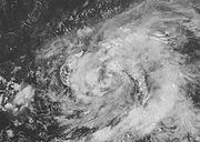
Hurricane Karen (2007)
Encyclopedia
Hurricane Karen was the eleventh named storm
and fourth hurricane of the 2007 Atlantic hurricane season
. Karen was a Cape Verde-type hurricane
that developed in the eastern tropical Atlantic
out of a large tropical wave. The storm briefly reached Category 1
hurricane intensity before slowly weakening due to increased wind shear
. As the storm remained away from land, no damages or fatalities were reported in association with Karen.
on September 21. The wave was not well-organized with only scattered thunderstorm
activity and large area of low pressure
. As the system tracked westward south of Cape Verde
, deep convection gradually increased, curved banding features became defined, and a poorly-defined circulation became evident. Early on September 23, Dvorak classification
estimates were introduced. Little change in organization took place until the evening of September 24. That evening, the low-level circulation and banding features became better defined as the system tracked west-northwest. Late that evening, the system was declared Tropical Depression Twelve while west-southwest of the Cape Verde islands.
The tropical depression quickly intensified into early on September 25 as the system continued to organize, and was upgraded to Tropical Storm Karen that morning. The strengthening trend was temporarily halted, and Karen remained a weak tropical storm with relatively shallow convection. Late that evening, new bursts of deep convection developed with the storm. Early on September 26, Karen intensified significantly and an inner core began to develop. That morning, a ragged eye
developed and the system strengthened into a hurricane with 75 mph (120 km/h) winds. The intensification trend was short-lived, and the storm leveled off that afternoon as upper-level wind shear
increased substantially due to the presence of a nearby tropical upper tropospheric trough
. The storm became less organized that evening. Hurricane Karen weakened to a tropical storm as flight data from NOAA Hurricane Hunters
confirmed surface winds of 72 mph (115 km/h) and a very large wind field late that evening. Operationally, Karen was classified as a strong tropical storm, but was reclassified as a Category 1 hurricane based on data from the reconnaissance
flight late on September 26 and the less organized structure of the storm at that time.
 A slow weakening trend began early on September 27 due to the increased shear while remaining on a west-northwest track. At the same time, the center of circulation became exposed at times due to the southwesterly wind shear. As a result, an unusual wind field was observed in that the strongest winds were recorded well to the east and to the northwest of the center. The weakening trend remained fairly slow that evening as the storm continued to produce persistent deep convection. The weakening trend accelerated on September 28 as the convection weakened and the circulation became more disorganized in the high-shear environment. By that morning, Karen weakened to a minimal tropical storm with 40 mph (65 km/h) winds. Karen also turned abruptly to the north for a short while, as convection interacted with the low-level center and southerly winds increased in the low-level environment. The weakening trend slowed that afternoon as deep convection returned to the disorganized storm. Early on September 29, the high wind shear continued and Karen weakened to a tropical depression with a very poorly-defined center. That afternoon, the circulation dissipated while east of the Lesser Antilles
. Remnant squalls continued across the area east of the Lesser Antilles for a few days after dissipation.
briefly assessed a minimal threat to the Lesser Antilles
, with one forecaster noting a 5% probability for the cyclone to produce tropical storm winds on Barbuda
. However, Karen stayed in the open Atlantic Ocean and never affected any land area. No incidents of damage or casualties were reported. No ship
reports of tropical storm-force or stronger were received. Some of the vorticity from Karen's remnants may have been responsible for the development of the short-lived Tropical Depression Fifteen on October 11.
Tropical cyclone
A tropical cyclone is a storm system characterized by a large low-pressure center and numerous thunderstorms that produce strong winds and heavy rain. Tropical cyclones strengthen when water evaporated from the ocean is released as the saturated air rises, resulting in condensation of water vapor...
and fourth hurricane of the 2007 Atlantic hurricane season
2007 Atlantic hurricane season
The 2007 Atlantic hurricane season was an active Atlantic hurricane season that produced 17 tropical cyclones, 15 tropical storms, six hurricanes, and two major hurricanes. It officially started on June 1 and ended on November 30, dates which conventionally delimit the...
. Karen was a Cape Verde-type hurricane
Cape Verde-type hurricane
A Cape Verde-type hurricane is an Atlantic hurricane that develops near the Cape Verde islands, off the west coast of Africa. The average hurricane season has about two Cape Verde-type hurricanes, which are usually the largest and most intense storms of the season because they often have plenty of...
that developed in the eastern tropical Atlantic
Atlantic Ocean
The Atlantic Ocean is the second-largest of the world's oceanic divisions. With a total area of about , it covers approximately 20% of the Earth's surface and about 26% of its water surface area...
out of a large tropical wave. The storm briefly reached Category 1
Saffir-Simpson Hurricane Scale
The Saffir–Simpson Hurricane Scale , or the Saffir–Simpson Hurricane Wind Scale , classifies hurricanes — Western Hemisphere tropical cyclones that exceed the intensities of tropical depressions and tropical storms — into five categories distinguished by the intensities of their sustained winds...
hurricane intensity before slowly weakening due to increased wind shear
Wind shear
Wind shear, sometimes referred to as windshear or wind gradient, is a difference in wind speed and direction over a relatively short distance in the atmosphere...
. As the storm remained away from land, no damages or fatalities were reported in association with Karen.
Meteorological history
The system began as a tropical wave that emerged off the west coast of AfricaAfrica
Africa is the world's second largest and second most populous continent, after Asia. At about 30.2 million km² including adjacent islands, it covers 6% of the Earth's total surface area and 20.4% of the total land area...
on September 21. The wave was not well-organized with only scattered thunderstorm
Thunderstorm
A thunderstorm, also known as an electrical storm, a lightning storm, thundershower or simply a storm is a form of weather characterized by the presence of lightning and its acoustic effect on the Earth's atmosphere known as thunder. The meteorologically assigned cloud type associated with the...
activity and large area of low pressure
Low pressure area
A low-pressure area, or "low", is a region where the atmospheric pressure at sea level is below that of surrounding locations. Low-pressure systems form under areas of wind divergence which occur in upper levels of the troposphere. The formation process of a low-pressure area is known as...
. As the system tracked westward south of Cape Verde
Cape Verde
The Republic of Cape Verde is an island country, spanning an archipelago of 10 islands located in the central Atlantic Ocean, 570 kilometres off the coast of Western Africa...
, deep convection gradually increased, curved banding features became defined, and a poorly-defined circulation became evident. Early on September 23, Dvorak classification
Dvorak technique
The Dvorak technique is a widely used system to subjectively estimate tropical cyclone intensity based solely on visible and infrared satellite images. Several agencies issue Dvorak intensity numbers for cyclones of sufficient intensity...
estimates were introduced. Little change in organization took place until the evening of September 24. That evening, the low-level circulation and banding features became better defined as the system tracked west-northwest. Late that evening, the system was declared Tropical Depression Twelve while west-southwest of the Cape Verde islands.
The tropical depression quickly intensified into early on September 25 as the system continued to organize, and was upgraded to Tropical Storm Karen that morning. The strengthening trend was temporarily halted, and Karen remained a weak tropical storm with relatively shallow convection. Late that evening, new bursts of deep convection developed with the storm. Early on September 26, Karen intensified significantly and an inner core began to develop. That morning, a ragged eye
Eye (cyclone)
The eye is a region of mostly calm weather found at the center of strong tropical cyclones. The eye of a storm is a roughly circular area and typically 30–65 km in diameter. It is surrounded by the eyewall, a ring of towering thunderstorms where the second most severe weather of a cyclone...
developed and the system strengthened into a hurricane with 75 mph (120 km/h) winds. The intensification trend was short-lived, and the storm leveled off that afternoon as upper-level wind shear
Wind shear
Wind shear, sometimes referred to as windshear or wind gradient, is a difference in wind speed and direction over a relatively short distance in the atmosphere...
increased substantially due to the presence of a nearby tropical upper tropospheric trough
Tropical Upper Tropospheric Trough
A tropical upper tropospheric trough , also known as the mid-oceanic trough, is a trough situated in upper-level tropics. Its formation is usually caused by the intrusion of energy and wind from the mid-latitudes into the tropics. It can also develop from the inverted trough adjacent to an upper...
. The storm became less organized that evening. Hurricane Karen weakened to a tropical storm as flight data from NOAA Hurricane Hunters
Hurricane Hunters
The Hurricane Hunters are aircraft that fly into tropical cyclones in the North Atlantic Ocean and Northeastern Pacific Ocean for the specific purpose of directly measuring weather data in and around those storms. In the United States, the Air Force, Navy, and NOAA units have all participated in...
confirmed surface winds of 72 mph (115 km/h) and a very large wind field late that evening. Operationally, Karen was classified as a strong tropical storm, but was reclassified as a Category 1 hurricane based on data from the reconnaissance
Reconnaissance
Reconnaissance is the military term for exploring beyond the area occupied by friendly forces to gain information about enemy forces or features of the environment....
flight late on September 26 and the less organized structure of the storm at that time.
Lesser Antilles
The Lesser Antilles are a long, partly volcanic island arc in the Western Hemisphere. Most of its islands form the eastern boundary of the Caribbean Sea with the Atlantic Ocean, with the remainder located in the southern Caribbean just north of South America...
. Remnant squalls continued across the area east of the Lesser Antilles for a few days after dissipation.
Impact
The National Hurricane CenterNational Hurricane Center
The National Hurricane Center , located at Florida International University in Miami, Florida, is the division of the National Weather Service responsible for tracking and predicting weather systems within the tropics between the Prime Meridian and the 140th meridian west poleward to the 30th...
briefly assessed a minimal threat to the Lesser Antilles
Lesser Antilles
The Lesser Antilles are a long, partly volcanic island arc in the Western Hemisphere. Most of its islands form the eastern boundary of the Caribbean Sea with the Atlantic Ocean, with the remainder located in the southern Caribbean just north of South America...
, with one forecaster noting a 5% probability for the cyclone to produce tropical storm winds on Barbuda
Barbuda
Barbuda is an island in the Eastern Caribbean, and forms part of the state of Antigua and Barbuda. It has a population of about 1,500, most of whom live in the town of Codrington.-Location:...
. However, Karen stayed in the open Atlantic Ocean and never affected any land area. No incidents of damage or casualties were reported. No ship
Ship
Since the end of the age of sail a ship has been any large buoyant marine vessel. Ships are generally distinguished from boats based on size and cargo or passenger capacity. Ships are used on lakes, seas, and rivers for a variety of activities, such as the transport of people or goods, fishing,...
reports of tropical storm-force or stronger were received. Some of the vorticity from Karen's remnants may have been responsible for the development of the short-lived Tropical Depression Fifteen on October 11.
See also
- 2007 Atlantic hurricane season2007 Atlantic hurricane seasonThe 2007 Atlantic hurricane season was an active Atlantic hurricane season that produced 17 tropical cyclones, 15 tropical storms, six hurricanes, and two major hurricanes. It officially started on June 1 and ended on November 30, dates which conventionally delimit the...
- Timeline of the 2007 Atlantic hurricane seasonTimeline of the 2007 Atlantic hurricane seasonThis timeline documents all the storm formations, strengthening, weakening, landfalls, extratropical transitions, as well as dissipation during the 2007 Atlantic hurricane season. The season officially began on June 1, 2007, and ended on November 30, although Subtropical Storm Andrea and Tropical...
- List of storms in the 2007 Atlantic hurricane season
- Other storms of the same name
External links
- The NHC's archive on Hurricane Karen