
Tree-line
Encyclopedia
Tree
A tree is a perennial woody plant. It is most often defined as a woody plant that has many secondary branches supported clear of the ground on a single main stem or trunk with clear apical dominance. A minimum height specification at maturity is cited by some authors, varying from 3 m to...
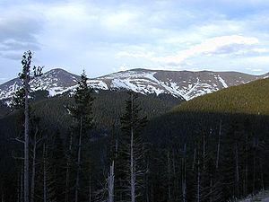
s are capable of growing. Beyond the tree line, they are unable to grow because of inappropriate environmental conditions (usually cold temperatures or lack of moisture). Some distinguish additionally a deeper timberline, where trees form a forest with a closed canopy.
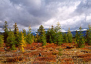
At the tree line, tree growth is often very stunted, with the last trees forming low, densely matted bushes. If it is caused by wind, it is known as krummholz
Krummholz
Krummholz or Krumholtz formation — also called Knieholz — is a particular feature of subarctic and subalpine tree line landscapes. Continual exposure to fierce, freezing winds causes vegetation to become stunted and deformed...
formation, from the German
German language
German is a West Germanic language, related to and classified alongside English and Dutch. With an estimated 90 – 98 million native speakers, German is one of the world's major languages and is the most widely-spoken first language in the European Union....
for 'twisted wood'.
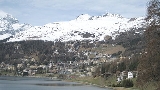
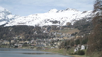
The tree line, like many other natural lines (lake
Lake
A lake is a body of relatively still fresh or salt water of considerable size, localized in a basin, that is surrounded by land. Lakes are inland and not part of the ocean and therefore are distinct from lagoons, and are larger and deeper than ponds. Lakes can be contrasted with rivers or streams,...
boundaries, for example), appears well-defined from a distance, but upon sufficiently close inspection, it is a gradual transition in most places. Trees grow shorter towards the inhospitable climate until they simply stop growing.
Alpine
The highest elevation that sustains trees; higher up, it is too cold or snow cover persists for too much of the year, to sustain trees. Usually associated with mountainMountain
Image:Himalaya_annotated.jpg|thumb|right|The Himalayan mountain range with Mount Everestrect 58 14 160 49 Chomo Lonzorect 200 28 335 52 Makalurect 378 24 566 45 Mount Everestrect 188 581 920 656 Tibetan Plateaurect 250 406 340 427 Rong River...
s, the climate
Climate
Climate encompasses the statistics of temperature, humidity, atmospheric pressure, wind, rainfall, atmospheric particle count and other meteorological elemental measurements in a given region over long periods...
above the tree line is called an alpine climate
Alpine climate
Alpine climate is the average weather for a region above the tree line. This climate is also referred to as mountain climate or highland climate....
, and the terrain can be described as alpine tundra
Alpine tundra
Alpine tundra is a natural region that does not contain trees because it is at high altitude. Alpine tundra is distinguished from arctic tundra, because alpine soils are generally better drained than arctic soils...
. In the northern hemisphere treelines on north-facing slopes are lower than on than south-facing slopes because increased shade means the snowpack
Snowpack
Snowpack forms from layers of snow that accumulate in geographic regions and high altitudes where the climate includes cold weather for extended periods during the year. Snowpacks are an important water resource that feed streams and rivers as they melt. Snowpacks are the drinking water source for...
takes longer to melt which shortens the growing season for trees. This is reversed in the southern hemisphere.
Desert
The driest places that trees can grow; drier desertDesert
A desert is a landscape or region that receives an extremely low amount of precipitation, less than enough to support growth of most plants. Most deserts have an average annual precipitation of less than...
areas having insufficient rainfall to sustain trees. These tend to be called the "lower" tree line and occur below about 5000 ft (1500 m) elevation in the Desert Southwestern United States
Southwestern United States
The Southwestern United States is a region defined in different ways by different sources. Broad definitions include nearly a quarter of the United States, including Arizona, California, Colorado, Nevada, New Mexico, Oklahoma, Texas and Utah...
. The desert treeline tends to be lower on pole-facing slopes than equator-facing slopes, because the increased shade on a pole-facing slope keeps those slopes cooler and prevents moisture from evaporating as quickly, giving trees a longer growing season and more access to water.
Desert-alpine
In some mountainous areas, higher elevations above the condensationCondensation
Condensation is the change of the physical state of matter from gaseous phase into liquid phase, and is the reverse of vaporization. When the transition happens from the gaseous phase into the solid phase directly, the change is called deposition....
line or on equator-facing and leeward slopes can result in low rainfall and increased exposure to solar radiation. This dries out the soil, resulting in a localized arid environment unsuitable for trees. Many south-facing ridges of the mountains of the Western U.S. have a lower treeline than the northern faces because of increased sun exposure and aridity.
Double
Different tree species have different tolerances to drought and cold. Mountain ranges isolated by oceans or deserts may have restricted reportoires of tree species with gaps that are above the alpine tree line for some species yet below the desert tree line for others. For example several mountain ranges in the Great BasinGreat Basin
The Great Basin is the largest area of contiguous endorheic watersheds in North America and is noted for its arid conditions and Basin and Range topography that varies from the North American low point at Badwater Basin to the highest point of the contiguous United States, less than away at the...
of North America
North America
North America is a continent wholly within the Northern Hemisphere and almost wholly within the Western Hemisphere. It is also considered a northern subcontinent of the Americas...
have lower belts of Pinyon Pines
Single-leaf Pinyon
The Single-leaf Pinyon, ', is a pine in the pinyon pine group, native to the United States and northwest Mexico. The range is in southernmost Idaho, western Utah, Arizona, southwest New Mexico, Nevada, eastern and southern California and northern Baja California.It occurs at moderate altitudes from...
and Junipers
Juniperus osteosperma
Juniperus osteosperma is a shrub or small tree reaching 3-6 m tall. It is native to the southwestern United States, in Utah, Nevada, Arizona, western New Mexico, western Colorado, Wyoming, southern Montana, southern Idaho and eastern California...
separated by intermediate brushy but treeless zones from upper belts of Limber
Limber Pine
The Limber Pine, Pinus flexilis, is a species of pine tree-the family Pinaceae that occurs in the mountains of the Western United States, Mexico, and Canada. It is also called Southwestern White Pine and Rocky Mountain White Pine...
and Bristlecone Pines
Great Basin Bristlecone Pine
Pinus longaeva, the Great Basin Bristlecone Pine, is a long-living species of tree found in the higher mountains of the southwest United States. The species is one of three closely related trees known as bristlecone pines and is sometimes known as the Intermountain or Western bristlecone pine...
.
Exposure
On coastCoast
A coastline or seashore is the area where land meets the sea or ocean. A precise line that can be called a coastline cannot be determined due to the dynamic nature of tides. The term "coastal zone" can be used instead, which is a spatial zone where interaction of the sea and land processes occurs...
s and isolated mountains the tree line is often much lower than in corresponding altitudes inland and in larger, more complex mountain systems, because strong wind
Wind
Wind is the flow of gases on a large scale. On Earth, wind consists of the bulk movement of air. In outer space, solar wind is the movement of gases or charged particles from the sun through space, while planetary wind is the outgassing of light chemical elements from a planet's atmosphere into space...
s reduce tree growth. In addition the lack of suitable soil, such as along talus slopes
Scree
Scree, also called talus, is a term given to an accumulation of broken rock fragments at the base of crags, mountain cliffs, or valley shoulders. Landforms associated with these materials are sometimes called scree slopes or talus piles...
or exposed rock formations, prevents trees from gaining an adequate foothold and exposes them to drought and sun.
Arctic
The northernmost latitudeLatitude
In geography, the latitude of a location on the Earth is the angular distance of that location south or north of the Equator. The latitude is an angle, and is usually measured in degrees . The equator has a latitude of 0°, the North pole has a latitude of 90° north , and the South pole has a...
in the Northern Hemisphere
Northern Hemisphere
The Northern Hemisphere is the half of a planet that is north of its equator—the word hemisphere literally means “half sphere”. It is also that half of the celestial sphere north of the celestial equator...
where trees can grow; farther north, it is too cold all year round to sustain trees. Extremely cold temperatures, especially when prolonged, can result in freezing of the internal sap of trees, killing them. In addition, permafrost
Permafrost
In geology, permafrost, cryotic soil or permafrost soil is soil at or below the freezing point of water for two or more years. Ice is not always present, as may be in the case of nonporous bedrock, but it frequently occurs and it may be in amounts exceeding the potential hydraulic saturation of...
in the soil can prevent trees from getting their roots deep enough for the necessary structural support.
Antarctic
The southernmost latitude in the Southern HemisphereSouthern Hemisphere
The Southern Hemisphere is the part of Earth that lies south of the equator. The word hemisphere literally means 'half ball' or "half sphere"...
where trees can grow; further south, it is too cold to sustain trees. It is a theoretical concept that does not have any defined location. No trees grow in Antarctica or the sub-antarctic islands. This tree line would be the southernmost point in the environment at which trees can no longer grow, except there are no landmasses that have a true treeline analogous to the arctic treeline.
Other
The immediate environment is too extreme for trees to grow. This can be caused by geothermal exposure associated with hot springs or volcanoes, such as at Yellowstone, high soil acidity near bogBog
A bog, quagmire or mire is a wetland that accumulates acidic peat, a deposit of dead plant material—often mosses or, in Arctic climates, lichens....
s, high salinity associated with playas
Dry lake
Dry lakes are ephemeral lakebeds, or a remnant of an endorheic lake. Such flats consist of fine-grained sediments infused with alkali salts. Dry lakes are also referred to as alkali flats, sabkhas, playas or mud flats...
or salt lakes, or ground that is saturated with groundwater that excludes oxygen
Oxygen
Oxygen is the element with atomic number 8 and represented by the symbol O. Its name derives from the Greek roots ὀξύς and -γενής , because at the time of naming, it was mistakenly thought that all acids required oxygen in their composition...
from the soil, which most tree root
Root
In vascular plants, the root is the organ of a plant that typically lies below the surface of the soil. This is not always the case, however, since a root can also be aerial or aerating . Furthermore, a stem normally occurring below ground is not exceptional either...
s need for growth. The margins of muskeg
Muskeg
Muskeg is an acidic soil type common in Arctic and boreal areas, although it is found in other northern climates as well. Muskeg is approximately synonymous with bogland but muskeg is the standard term in Western Canada and Alaska, while 'bog' is common elsewhere. The term is of Cree origin, maskek...
s and bogs are common examples of these types of open areas. However, no such line exists for swamp
Swamp
A swamp is a wetland with some flooding of large areas of land by shallow bodies of water. A swamp generally has a large number of hammocks, or dry-land protrusions, covered by aquatic vegetation, or vegetation that tolerates periodical inundation. The two main types of swamp are "true" or swamp...
s, where trees, such as Bald cypress
Taxodium
Taxodium is a genus of one to three species of extremely flood-tolerant conifers in the cypress family, Cupressaceae...
and the many mangrove
Mangrove
Mangroves are various kinds of trees up to medium height and shrubs that grow in saline coastal sediment habitats in the tropics and subtropics – mainly between latitudes N and S...
species, have adapted to growing in permanently waterlogged soil. In some colder parts of the world there are tree lines around swamps, where there are no local tree species that can develop. There are also man-made pollution tree lines in weather exposed areas, where new tree lines have developed because of the increased stress of pollution. Example are around Nikel
Nikel
Nikel is an urban locality and the administrative center of Pechengsky District of Murmansk Oblast, Russia, located on the shores of Lake Kuets-Yarvi northwest of Murmansk and from the Norwegian border. Population: 18,000 .-History:In the 1920 Treaty of Tartu, Soviet Russia ceded the area of...
in Russia and previously in the Erzgebirge.
Typical vegetation
Eurasia
- Dahurian LarchDahurian LarchDahurian Larch, Larix gmelinii, is a species of larch native to eastern Siberia, and adjacent northeastern Mongolia, northeastern China and North Korea.-Description:...
(Larix gmelinii) - Macedonian PineMacedonian PinePinus peuce is a species of pine native to the mountains of Macedonia, Bulgaria, Albania, Montenegro, Kosovo, the extreme southwest of Serbia, and the extreme north of Greece, growing typically at 1,000-2,200 m altitude. It often reaches the alpine tree line in this area...
(Pinus peuce) - Swiss PineSwiss PineThe Swiss Pine or Arolla Pine, Pinus cembra, is a species of pine tree that occurs in the Alps and Carpathian Mountains of central Europe, in Poland , Switzerland, France, Italy, Austria, Germany, Slovenia, Slovakia, Ukraine and Romania. It typically grows at to altitude. It often reaches the...
(Pinus cembra) - Mountain PineMountain PinePinus mugo, the Mountain Pine or Mugo Pine, is a high-altitude European pine, found in the Pyrenees, Alps, Erzgebirge, Carpathians, northern Apennines and Balkan Peninsula mountains from 1,000 m to 2,200 m, occasionally as low as 200 m in the north of the range in Germany and Poland, and as high...
(Pinus mugo) - Arctic White Birch (Betula pubescens subsp. tortuosa)
North America
- Subalpine firSubalpine FirThe Subalpine Fir or Rocky Mountain Fir is a western North American fir, native to the mountains of Yukon, British Columbia and western Alberta in Canada; southeastern Alaska, Washington, Oregon, Idaho, western Montana, Wyoming, Utah, Colorado, New Mexico, Arizona, northeastern Nevada, and the...
(Abies lasiocarpa) - Subalpine LarchSubalpine LarchLarix lyallii, the Subalpine Larch, or simply Alpine Larch, is a coniferous tree native to northwestern North America. It lives at very high altitudes in the Rocky Mountains of Idaho, Montana, British Columbia, and Alberta...
(Larix lyallii) - Engelmann SpruceEngelmann SprucePicea engelmannii is a species of spruce native to western North America, from central British Columbia and southwest Alberta, southwest to northern California and southeast to Arizona and New Mexico; there are also two isolated populations in northern Mexico...
(Picea engelmannii) - Whitebark PineWhitebark PinePinus albicaulis, known commonly as Whitebark Pine, Pitch Pine, Scrub Pine, and Creeping Pine occurs in the mountains of the Western United States and Canada, specifically the subalpine areas of the Sierra Nevada, the Cascade Range, the Pacific Coast Ranges, and the northern Rocky Mountains –...
(Pinus albicaulis) - Great Basin Bristlecone PineGreat Basin Bristlecone PinePinus longaeva, the Great Basin Bristlecone Pine, is a long-living species of tree found in the higher mountains of the southwest United States. The species is one of three closely related trees known as bristlecone pines and is sometimes known as the Intermountain or Western bristlecone pine...
(Pinus longaeva) - Rocky Mountains Bristlecone PineRocky Mountains Bristlecone PinePinus aristata, the Rocky Mountain Bristlecone Pine, is a species of pine native to the United States. It appears in the Rocky Mountains in Colorado and northern New Mexico, with an isolated population in the San Francisco Peaks in Arizona...
(Pinus aristata) - Foxtail PineFoxtail PineThe Foxtail Pine is a rare pine that is endemic to California, United States, where it is found in two areas with a separate subspecies in each, the typical subsp. balfouriana in the Klamath Mountains, and subsp. austrina in the southern Sierra Nevada.-Description:Foxtail Pine is a tree to tall,...
(Pinus balfouriana) - Limber PineLimber PineThe Limber Pine, Pinus flexilis, is a species of pine tree-the family Pinaceae that occurs in the mountains of the Western United States, Mexico, and Canada. It is also called Southwestern White Pine and Rocky Mountain White Pine...
(Pinus flexilis) - Potosi PinyonPotosi PinyonPinus culminicola, commonly known as Potosi Pinyon, is a pine in the pinyon pine group, native and endemic to northeast Mexico. The range is highly localised, confined to a small area of high summits in the northern Sierra Madre Oriental in Coahuila and Nuevo León, and only abundant on the highest...
(Pinus culminicola) - Black spruceBlack SprucePicea mariana is a species of spruce native to northern North America, from Newfoundland west to Alaska, and south to northern New York, Minnesota and central British Columbia...
(Picea mariana) - Hartweg's PineHartweg's PineHartweg's Pine, Pinus hartwegii; syn. P. rudis, P. donnell-smithii) is a pine native to the mountains of Mexico and Central America east to Honduras. It is a very high altitude species, growing at altitudes of 2500-4300 m, and forms the alpine tree line on most of Mexico's higher mountains. It is...
(Pinus hartwegii)
South America

- Antarctic BeechNothofagus antarcticaNothofagus antarctica , is a deciduous tree or shrub native to southern Chile and Argentina from about 36°S to Tierra del Fuego . The southernmost occurrence is on Hoste Island, making it the southernmost trees on earth...
(Nothofagus antarctica) - Lenga Beech (Nothofagus pumilio)
- PolylepisPolylepisPolylepis is a genus containing about twenty species of shrubs or trees native to the mid- and high-elevation regions of the tropical Andes. This group is unique in the rose family in that it is predominantly wind-pollinated. They are usually gnarled in shape, but in certain areas some trees are...
(Polylepis tarapacana)
Alpine tree lines
The alpine tree line at a location is dependent on local variables, such as aspectAspect (geography)
In physical geography, aspect generally refers to the horizontal direction to which a mountain slope faces. For example, a slope on the eastern edge of the Rockies toward the Great Plains is described as having an easterly aspect...
of slope, rain shadow
Rain shadow
A rain shadow is a dry area on the lee side of a mountainous area. The mountains block the passage of rain-producing weather systems, casting a "shadow" of dryness behind them. As shown by the diagram to the right, the warm moist air is "pulled" by the prevailing winds over a mountain...
and proximity to either geographical pole
Geographical pole
A geographical pole is either of the two points—the north pole and the south pole—on the surface of a rotating planet where the axis of rotation meets the surface of the body...
. In addition, in some tropical or island localities, the lack of biogeographical access to species that have evolved in a sub-alpine environment, can result in lower tree lines than one might expect by climate alone.
Averaging over many locations and local microclimate
Microclimate
A microclimate is a local atmospheric zone where the climate differs from the surrounding area. The term may refer to areas as small as a few square feet or as large as many square miles...
s, the treeline rises 75 metres (246.1 ft) when moving 1 degree south from 70 to 50°N, and 130 metres (426.5 ft) per degree from 50 to 30°N. Between 30°N and 20°S, the treeline is roughly constant, between 3500 and 4000 m (11,482.9 and 13,123.4 ft).
Here is a list of approximate tree lines from locations around the globe:
| Location | Approx. latitude | Approx. elevation of tree line | Notes | |
|---|---|---|---|---|
| (m) | (ft) | |||
| Abisko Abisko Abisko is a village in northern Sweden, near the Abisko National Park located 4 km west of the village. It had 85 inhabitants as of 2005.-Transportation:... , Sweden Sweden Sweden , officially the Kingdom of Sweden , is a Nordic country on the Scandinavian Peninsula in Northern Europe. Sweden borders with Norway and Finland and is connected to Denmark by a bridge-tunnel across the Öresund.... |
68°N | 650 | 2,132.5 | |
| Chugach Mountains, Alaska Chugach Mountains The Chugach Mountains of southern Alaska are the northernmost of the several mountain ranges that make up the Pacific Coast Ranges of the western edge of North America. The range is about 500 km long, running generally east-west. Its highest point is Mount Marcus Baker, at , but most of its... |
61°N | 700 | 2,296.6 | Tree line around 1500 feet or lower in coastal areas |
| Norway Norway Norway , officially the Kingdom of Norway, is a Nordic unitary constitutional monarchy whose territory comprises the western portion of the Scandinavian Peninsula, Jan Mayen, and the Arctic archipelago of Svalbard and Bouvet Island. Norway has a total area of and a population of about 4.9 million... |
61°N | 1100 | 3,608.9 | Much lower near the coast, down to 5–600 metres. At 71°N, in Finnmark county, the tree-line is below sea level (Arctic tree line). |
| Scotland Scotland Scotland is a country that is part of the United Kingdom. Occupying the northern third of the island of Great Britain, it shares a border with England to the south and is bounded by the North Sea to the east, the Atlantic Ocean to the north and west, and the North Channel and Irish Sea to the... |
57°N | 500 | 1,640.4 | Strong maritime influence serves to cool summer and restrict tree growth |
| Canadian Rockies Canadian Rockies The Canadian Rockies comprise the Canadian segment of the North American Rocky Mountains range. They are the eastern part of the Canadian Cordillera, extending from the Interior Plains of Alberta to the Rocky Mountain Trench of British Columbia. The southern end borders Idaho and Montana of the USA... |
51°N | 2400 | 7,874 | |
| Olympic Mountains Olympic Mountains The Olympic Mountains is a mountain range on the Olympic Peninsula of western Washington in the United States. The mountains, part of the Pacific Coast Ranges, are not especially high - Mount Olympus is the highest at - but the western slopes of the Olympics rise directly out of the Pacific... WA, USA |
47°N | 1500 | 4,921.3 | Heavy winter snowpack buries young trees until late summer |
| Swiss Alps Swiss Alps The Swiss Alps are the portion of the Alps mountain range that lies within Switzerland. Because of their central position within the entire Alpine range, they are also known as the Central Alps.... |
47°N | 2200 | 7,217.8 | |
| Mount Katahdin Mount Katahdin Mount Katahdin is the highest mountain in Maine at . Named Katahdin by the Penobscot Indians, the term means "The Greatest Mountain". Katahdin is the centerpiece of Baxter State Park: a steep, tall mountain formed from underground magma. The flora and fauna on the mountain are typical of those... , Maine Maine Maine is a state in the New England region of the northeastern United States, bordered by the Atlantic Ocean to the east and south, New Hampshire to the west, and the Canadian provinces of Quebec to the northwest and New Brunswick to the northeast. Maine is both the northernmost and easternmost... , USA |
46°N | 1150 | 3,773 | |
| Eastern Alps Eastern Alps Eastern Alps is the name given to the eastern half of the Alps, usually defined as the area east of the Splügen Pass in eastern Switzerland. North of the Splügen Pass, the Posterior Rhine forms the border, and south of the pass, the Liro river and Lake Como form the boundary line.-Geography:The... , Austria Austria Austria , officially the Republic of Austria , is a landlocked country of roughly 8.4 million people in Central Europe. It is bordered by the Czech Republic and Germany to the north, Slovakia and Hungary to the east, Slovenia and Italy to the south, and Switzerland and Liechtenstein to the... , Italy Italy Italy , officially the Italian Republic languages]] under the European Charter for Regional or Minority Languages. In each of these, Italy's official name is as follows:;;;;;;;;), is a unitary parliamentary republic in South-Central Europe. To the north it borders France, Switzerland, Austria and... |
46°N | 1750 | 5,741.5 | more exposure to Russian cold winds than Western Alps |
| Alps of Piedmont Piedmont Piedmont is one of the 20 regions of Italy. It has an area of 25,402 square kilometres and a population of about 4.4 million. The capital of Piedmont is Turin. The main local language is Piedmontese. Occitan is also spoken by a minority in the Occitan Valleys situated in the Provinces of... , Northwestern Italy Italy Italy , officially the Italian Republic languages]] under the European Charter for Regional or Minority Languages. In each of these, Italy's official name is as follows:;;;;;;;;), is a unitary parliamentary republic in South-Central Europe. To the north it borders France, Switzerland, Austria and... |
45°N | 2100 | 6,889.8 | |
| New Hampshire New Hampshire New Hampshire is a state in the New England region of the northeastern United States of America. The state was named after the southern English county of Hampshire. It is bordered by Massachusetts to the south, Vermont to the west, Maine and the Atlantic Ocean to the east, and the Canadian... , USA |
44°N | 1400 | 4,593.2 | Some peaks have even lower treelines because of fire and subsequent loss of soil, such as Grand Monadnock and Mount Chocorua Mount Chocorua Mount Chocorua is a summit in the White Mountains of New Hampshire. At an elevation of it is the easternmost peak of the Sandwich Range.... . |
| Wyoming Wyoming Wyoming is a state in the mountain region of the Western United States. The western two thirds of the state is covered mostly with the mountain ranges and rangelands in the foothills of the Eastern Rocky Mountains, while the eastern third of the state is high elevation prairie known as the High... , USA |
43°N | 3000 | 9,842.5 | |
| Rila Rila Rila is a mountain range in southwestern Bulgaria and the highest mountain range of Bulgaria and the Balkans, with its highest peak being Musala at 2,925 m... and Pirin Pirin The Pirin Mountains are a mountain range in southwestern Bulgaria, with Vihren the highest peak, situated at . The range extends about 40 km northwest-southeast, and about 25 km wide. Most of the range is protected in the Pirin National Park... Mountains, Bulgaria Bulgaria Bulgaria , officially the Republic of Bulgaria , is a parliamentary democracy within a unitary constitutional republic in Southeast Europe. The country borders Romania to the north, Serbia and Macedonia to the west, Greece and Turkey to the south, as well as the Black Sea to the east... |
42°N | 2300 | 7,545.9 | Up to 2600m on favorable locations. Mountain Pine Mountain Pine Pinus mugo, the Mountain Pine or Mugo Pine, is a high-altitude European pine, found in the Pyrenees, Alps, Erzgebirge, Carpathians, northern Apennines and Balkan Peninsula mountains from 1,000 m to 2,200 m, occasionally as low as 200 m in the north of the range in Germany and Poland, and as high... is the most common tree line species. |
| Pyrenees Pyrenees The Pyrenees is a range of mountains in southwest Europe that forms a natural border between France and Spain... Spain Spain Spain , officially the Kingdom of Spain languages]] under the European Charter for Regional or Minority Languages. In each of these, Spain's official name is as follows:;;;;;;), is a country and member state of the European Union located in southwestern Europe on the Iberian Peninsula... , France France The French Republic , The French Republic , The French Republic , (commonly known as France , is a unitary semi-presidential republic in Western Europe with several overseas territories and islands located on other continents and in the Indian, Pacific, and Atlantic oceans. Metropolitan France... , Andorra Andorra Andorra , officially the Principality of Andorra , also called the Principality of the Valleys of Andorra, , is a small landlocked country in southwestern Europe, located in the eastern Pyrenees mountains and bordered by Spain and France. It is the sixth smallest nation in Europe having an area of... |
42°N | 2300 | 7,545.9 | Mountain Pine Mountain Pine Pinus mugo, the Mountain Pine or Mugo Pine, is a high-altitude European pine, found in the Pyrenees, Alps, Erzgebirge, Carpathians, northern Apennines and Balkan Peninsula mountains from 1,000 m to 2,200 m, occasionally as low as 200 m in the north of the range in Germany and Poland, and as high... is the tree line species |
| Wasatch Mountains, Utah Utah Utah is a state in the Western United States. It was the 45th state to join the Union, on January 4, 1896. Approximately 80% of Utah's 2,763,885 people live along the Wasatch Front, centering on Salt Lake City. This leaves vast expanses of the state nearly uninhabited, making the population the... , USA |
40°N | 2900 | 9,514.4 | Higher (nearly 11,000 feet) in the Uintas |
| Rocky Mountain NP Rocky Mountain National Park Rocky Mountain National Park is a national park located in the north-central region of the U.S. state of Colorado.It features majestic mountain views, a variety of wildlife, varied climates and environments—from wooded forests to mountain tundra—and easy access to back-country trails... , USA |
40°N | 3550 | 11,647 | On warm southwest slopes |
| 3250 | 10,662.7 | On northeast slopes | ||
| Japanese Alps Japanese Alps The is a series of mountain ranges in Japan that bisect the main island of Honshū. The name was coined by William Gowland, the "Father of Japanese Archaeology," and later popularized by Reverend Walter Weston , an English missionary for whom a memorial plaque is located at Kamikochi, a tourist... |
39°N | 2900 | 9,514.4 | |
| Yosemite Yosemite National Park Yosemite National Park is a United States National Park spanning eastern portions of Tuolumne, Mariposa and Madera counties in east central California, United States. The park covers an area of and reaches across the western slopes of the Sierra Nevada mountain chain... , USA |
38°N | 3200 | 10,498.7 | West side of Sierra Nevada |
| 3600 | 11,811 | East side of Sierra Nevada | ||
| Sierra Nevada Sierra Nevada (Spain) The Sierra Nevada is a mountain range in the region of provinces of Granada and Almería in Spain. It contains the highest point of continental Spain, Mulhacén at 3478 m above sea level.... , Spain Spain Spain , officially the Kingdom of Spain languages]] under the European Charter for Regional or Minority Languages. In each of these, Spain's official name is as follows:;;;;;;), is a country and member state of the European Union located in southwestern Europe on the Iberian Peninsula... |
37°N | 2400 | 7,874 | Precipitation low in summer |
| Khumbu Khumbu Khumbu is located in northeastern Nepal on the Nepalese side of Mount Everest. It is part of the Solukhumbu District, which in turn is part of the Sagarmatha Zone. Khumbu is one of three subregions of the main Khambu and Sherpa settlement of the Himalaya, the other two being Solu and Pharak... , Himalaya |
28°N | 4200 | 13,779.5 | |
| Hawaii Hawaii Hawaii is the newest of the 50 U.S. states , and is the only U.S. state made up entirely of islands. It is the northernmost island group in Polynesia, occupying most of an archipelago in the central Pacific Ocean, southwest of the continental United States, southeast of Japan, and northeast of... , USA |
20°N | 3000 | 9,842.5 | Geographic isolation and no local tree species with high tolerance to cold temperatures. |
| Pico de Orizaba Pico de Orizaba The Pico de Orizaba, or Citlaltépetl , is a stratovolcano, the highest mountain in Mexico and the third highest in North America. It rises above sea level in the eastern end of the Trans-Mexican Volcanic Belt, on the border between the states of Veracruz and Puebla... , Mexico Mexico The United Mexican States , commonly known as Mexico , is a federal constitutional republic in North America. It is bordered on the north by the United States; on the south and west by the Pacific Ocean; on the southeast by Guatemala, Belize, and the Caribbean Sea; and on the east by the Gulf of... |
19°N | 4000 | 13,123.4 | |
| Costa Rica Costa Rica Costa Rica , officially the Republic of Costa Rica is a multilingual, multiethnic and multicultural country in Central America, bordered by Nicaragua to the north, Panama to the southeast, the Pacific Ocean to the west and the Caribbean Sea to the east.... |
9.5°N | 3400 | 11,154.9 | |
| Mount Kilimanjaro Mount Kilimanjaro Kilimanjaro, with its three volcanic cones, Kibo, Mawenzi, and Shira, is a dormant volcano in Kilimanjaro National Park, Tanzania and the highest mountain in Africa at above sea level .-Geology:... , Tanzania Tanzania The United Republic of Tanzania is a country in East Africa bordered by Kenya and Uganda to the north, Rwanda, Burundi, and the Democratic Republic of the Congo to the west, and Zambia, Malawi, and Mozambique to the south. The country's eastern borders lie on the Indian Ocean.Tanzania is a state... |
3°S | 3950 | 12,959.3 | |
| New Guinea New Guinea New Guinea is the world's second largest island, after Greenland, covering a land area of 786,000 km2. Located in the southwest Pacific Ocean, it lies geographically to the east of the Malay Archipelago, with which it is sometimes included as part of a greater Indo-Australian Archipelago... |
6°S | 3850 | 12,631.2 | |
| Andes Andes The Andes is the world's longest continental mountain range. It is a continual range of highlands along the western coast of South America. This range is about long, about to wide , and of an average height of about .Along its length, the Andes is split into several ranges, which are separated... , Peru Peru Peru , officially the Republic of Peru , is a country in western South America. It is bordered on the north by Ecuador and Colombia, on the east by Brazil, on the southeast by Bolivia, on the south by Chile, and on the west by the Pacific Ocean.... |
11°S | 3900 | 12,795.3 | East side; on west side tree growth is restricted by dryness |
| Andes Andes The Andes is the world's longest continental mountain range. It is a continual range of highlands along the western coast of South America. This range is about long, about to wide , and of an average height of about .Along its length, the Andes is split into several ranges, which are separated... , Bolivia Bolivia Bolivia officially known as Plurinational State of Bolivia , is a landlocked country in central South America. It is the poorest country in South America... |
18°S | 5200 | 17,060.4 | Western Cordillera; highest treeline in the world on the slopes of Sajama Volcano (Polylepis tarapacana) |
| 4100 | 13,451.4 | Eastern Cordillera; treeline is lower because of lower solar radiation (more humid climate) | ||
| Sierra de Córdoba Sierra de Córdoba The Sierras de Córdoba is a mountain range in central Argentina, located between the Pampas to the east and south, the Chaco to the north and the foothills of the Andes to the west... , Argentina Argentina Argentina , officially the Argentine Republic , is the second largest country in South America by land area, after Brazil. It is constituted as a federation of 23 provinces and an autonomous city, Buenos Aires... |
31°S | 2000 | 6,561.7 | Precipitation low above trade winds, also high exposure |
| Australian Alps Australian Alps The Australian Alps are the highest mountain ranges of mainland Australia. They are located in southeastern Australia and straddle the Australian Capital Territory, south-eastern New South Wales and eastern Victoria... , Australia Australia Australia , officially the Commonwealth of Australia, is a country in the Southern Hemisphere comprising the mainland of the Australian continent, the island of Tasmania, and numerous smaller islands in the Indian and Pacific Oceans. It is the world's sixth-largest country by total area... |
36°S | 2000 | 6,561.7 | West side of Australian Alps |
| 1700 | 5,577.4 | East side of Australian Alps | ||
| Andes Andes The Andes is the world's longest continental mountain range. It is a continual range of highlands along the western coast of South America. This range is about long, about to wide , and of an average height of about .Along its length, the Andes is split into several ranges, which are separated... , Laguna del Laja, Chile Chile Chile ,officially the Republic of Chile , is a country in South America occupying a long, narrow coastal strip between the Andes mountains to the east and the Pacific Ocean to the west. It borders Peru to the north, Bolivia to the northeast, Argentina to the east, and the Drake Passage in the far... |
37°S | 1600 | 5,249.3 | Temperature rather than precipitation restricts tree growth |
| Tasmania Tasmania Tasmania is an Australian island and state. It is south of the continent, separated by Bass Strait. The state includes the island of Tasmania—the 26th largest island in the world—and the surrounding islands. The state has a population of 507,626 , of whom almost half reside in the greater Hobart... , Australia Australia Australia , officially the Commonwealth of Australia, is a country in the Southern Hemisphere comprising the mainland of the Australian continent, the island of Tasmania, and numerous smaller islands in the Indian and Pacific Oceans. It is the world's sixth-largest country by total area... |
41°S | 1200 | 3,937 | Cold winters, strong cold Winds and cool summers with occasional summer snow restrict tree growth |
| South Island South Island The South Island is the larger of the two major islands of New Zealand, the other being the more populous North Island. It is bordered to the north by Cook Strait, to the west by the Tasman Sea, to the south and east by the Pacific Ocean... , New Zealand New Zealand New Zealand is an island country in the south-western Pacific Ocean comprising two main landmasses and numerous smaller islands. The country is situated some east of Australia across the Tasman Sea, and roughly south of the Pacific island nations of New Caledonia, Fiji, and Tonga... |
43°S | 1200 | 3,937 | Strong maritime influence serves to cool summer and restrict tree growth |
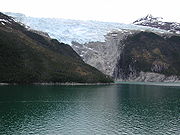
| Torres del Paine Torres del Paine National Park Torres del Paine National Park is a national park encompassing mountains, a glacier, a lake, and river-rich areas in southern Chilean Patagonia. The Cordillera del Paine is the centerpiece of the park. It lies in a transition area between the Magellanic subpolar forests and the Patagonian Steppes... , Chile Chile Chile ,officially the Republic of Chile , is a country in South America occupying a long, narrow coastal strip between the Andes mountains to the east and the Pacific Ocean to the west. It borders Peru to the north, Bolivia to the northeast, Argentina to the east, and the Drake Passage in the far... |
51°S | 950 | 3,116.8 | Strong influence from the Southern Patagonian Ice Field Southern Patagonian Ice Field The Southern Patagonian Ice Field , located at the Southern Patagonic Andes between Argentina and Chile, is the second largest contiguous extrapolar extent of ice in the world... serves to cool summer and restrict tree growth |
| Navarino Island, Chile Chile Chile ,officially the Republic of Chile , is a country in South America occupying a long, narrow coastal strip between the Andes mountains to the east and the Pacific Ocean to the west. It borders Peru to the north, Bolivia to the northeast, Argentina to the east, and the Drake Passage in the far... |
55°S | 600 | 1,968.5 | Strong maritime influence serves to cool summer and restrict tree growth |
Arctic tree lines
Like the alpine tree lines shown above, polar tree lines are heavily influenced by local variables such as aspectAspect (geography)
In physical geography, aspect generally refers to the horizontal direction to which a mountain slope faces. For example, a slope on the eastern edge of the Rockies toward the Great Plains is described as having an easterly aspect...
of slope and degree of shelter. In addition, permafrost
Permafrost
In geology, permafrost, cryotic soil or permafrost soil is soil at or below the freezing point of water for two or more years. Ice is not always present, as may be in the case of nonporous bedrock, but it frequently occurs and it may be in amounts exceeding the potential hydraulic saturation of...
has a major impact on the ability of trees to place roots into the ground. When roots are too shallow, trees are susceptible to windthrow
Windthrow
In forestry, windthrow refers to trees uprooted or broken by wind. Breakage of the tree bole instead of uprooting is sometimes called windsnap.- Causes :...
and erosion. Trees can often grow in river valleys at latitudes where they could not grow on a more exposed site. Maritime influences such as ocean currents also play a major role in determining how far from the equator trees can grow. Here are some typical polar treelines:
| Location | Approx. longitude | Approx. latitude of tree line | Notes |
|---|---|---|---|
| Norway Norway Norway , officially the Kingdom of Norway, is a Nordic unitary constitutional monarchy whose territory comprises the western portion of the Scandinavian Peninsula, Jan Mayen, and the Arctic archipelago of Svalbard and Bouvet Island. Norway has a total area of and a population of about 4.9 million... |
70°N | The North Atlantic current North Atlantic Current The North Atlantic Current is a powerful warm ocean current that continues the Gulf Stream northeast. West of Ireland it splits in two; one branch, the Canary Current, goes south, while the other continues north along the coast of northwestern Europe... makes Arctic climates in this region warmer than other coastal locations at comparable latitude. In particular the mild winters prevents permafrost Permafrost In geology, permafrost, cryotic soil or permafrost soil is soil at or below the freezing point of water for two or more years. Ice is not always present, as may be in the case of nonporous bedrock, but it frequently occurs and it may be in amounts exceeding the potential hydraulic saturation of... . |
|
| West Siberian Plain West Siberian Plain The West Siberian Plain is a large plain that occupies the western portion of Siberia, between the Ural Mountains in the west and the Yenisei River in the east, and by the Altay Mountains on the South-East. Much of the plain is poorly drained and consists of some of the world's largest swamps and... |
66°N | ||
| Central Siberian Plateau Central Siberian Plateau The Central Siberian Plateau is made up of sharply demarcated surfaces of varying altitudes occupying most of Siberia between the Yenisei and Lena rivers. It extends over an area of 3.5 million km². The highest point is the Putoran Mountains rising to 1701 m. To the north of the plateau are... |
72°N | Extreme continental climate Continental climate Continental climate is a climate characterized by important annual variation in temperature due to the lack of significant bodies of water nearby... means the summer is warm enough to allow tree growth at higher latitudes, extending to northernmost forests of the world at 72°28'N at Ary-Mas Ary-Mas Ary-Mas is a forest in Russia, Krasnoyarsk Krai, southern part of Taymyr Peninsula, southern bank of Novaya River. Ary-Mas from Dolgan language - forest island.... (102° 15' E) in the Novaya River valley, a tributary of the Khatanga River Khatanga River The Khatanga River is a river in Krasnoyarsk Krai in Russia. It begins at the confluence of the rivers Kotuy and Kheta. The Khatanga River is long; the area of its basin is 364,000 km². It flows into the Khatanga Gulf of the Laptev Sea, forming an estuary... and the more northern Lukunsky grove Lukunsky grove The Lukunsky grove is a forest in Russia, Krasnoyarsk Krai, southern bank of Lukunsk River, to the south from Khatanga River.It is the northernmost forest extension in the world. Ary-Mas to the west from Lukunsky grove is the northernmost isolated forest island, though located approximately 6... at 72°31'N, 105° 03' E east from Khatanga River. |
|
| Russian Far East Russian Far East Russian Far East is a term that refers to the Russian part of the Far East, i.e., extreme east parts of Russia, between Lake Baikal in Eastern Siberia and the Pacific Ocean... (Kamchatka Kamchatka Peninsula The Kamchatka Peninsula is a peninsula in the Russian Far East, with an area of . It lies between the Pacific Ocean to the east and the Sea of Okhotsk to the west... and Chukotka Chukchi Peninsula The Chukchi Peninsula, Chukotka Peninsula or Chukotski Peninsula , at about 66° N 172° W, is the northeastern extremity of Asia. Its eastern end is at Cape Dezhnev near the village of Uelen. It is bordered by the Chukchi Sea to the north, the Bering Sea to the south, and the Bering Strait to the... ) |
60°N | The Oyashio Current Oyashio Current , also known as Oya Siwo, Okhotsk or the Kurile current, is a cold subarctic ocean current that flows south and circulates counterclockwise in the western North Pacific Ocean. It collides with the Kuroshio Current off the eastern shore of Japan to form the North Pacific Current... and strong winds affect summer temperatures to prevent tree growth. The Aleutian Islands are almost completely treeless. |
|
| Alaska Alaska Alaska is the largest state in the United States by area. It is situated in the northwest extremity of the North American continent, with Canada to the east, the Arctic Ocean to the north, and the Pacific Ocean to the west and south, with Russia further west across the Bering Strait... |
68°N | Trees grow north to the south facing slopes of the Brooks Range. The mountains block cold air coming off of the Arctic Ocean. | |
| Northwest Territories Northwest Territories The Northwest Territories is a federal territory of Canada.Located in northern Canada, the territory borders Canada's two other territories, Yukon to the west and Nunavut to the east, and three provinces: British Columbia to the southwest, and Alberta and Saskatchewan to the south... , Canada Canada Canada is a North American country consisting of ten provinces and three territories. Located in the northern part of the continent, it extends from the Atlantic Ocean in the east to the Pacific Ocean in the west, and northward into the Arctic Ocean... |
69°N | Reaches north of the Arctic Circle because of the continental nature of the climate and warmer summer temperatures. | |
| Nunavut Nunavut Nunavut is the largest and newest federal territory of Canada; it was separated officially from the Northwest Territories on April 1, 1999, via the Nunavut Act and the Nunavut Land Claims Agreement Act, though the actual boundaries had been established in 1993... |
61°N | Influence of the very cold Hudson Bay Hudson Bay Hudson Bay , sometimes called Hudson's Bay, is a large body of saltwater in northeastern Canada. It drains a very large area, about , that includes parts of Ontario, Quebec, Saskatchewan, Alberta, most of Manitoba, southeastern Nunavut, as well as parts of North Dakota, South Dakota, Minnesota,... moves treeline southwards. |
|
| Labrador Peninsula Labrador Peninsula The Labrador Peninsula is a large peninsula in eastern Canada. It is bounded by the Hudson Bay to the west, the Hudson Strait to the north, the Labrador Sea to the east, and the Gulf of Saint Lawrence to the south-east... |
56°N | Very strong influence of the Labrador Current Labrador Current The Labrador Current is a cold current in the North Atlantic Ocean which flows from the Arctic Ocean south along the coast of Labrador and passes around Newfoundland, continuing south along the east coast of Nova Scotia... on summer temperatures. In parts of Labrador Labrador Labrador is the distinct, northerly region of the Canadian province of Newfoundland and Labrador. It comprises the mainland portion of the province, separated from the island of Newfoundland by the Strait of Belle Isle... , the treeline extends as far south as 53°N. |
|
| Greenland Greenland Greenland is an autonomous country within the Kingdom of Denmark, located between the Arctic and Atlantic Oceans, east of the Canadian Arctic Archipelago. Though physiographically a part of the continent of North America, Greenland has been politically and culturally associated with Europe for... |
64°N | Determined by experimental tree planting in the absence of native trees because of isolation from natural seed sources; a very few trees are surviving, but growing slowly, at Søndre Strømfjord Kangerlussuaq Fjord Kangerlussuaq Fjord is a long fjord in the Qeqqata municipality in central-western Greenland. The fjord is long and between and wide, flowing from the estuary of Qinnguata Kuussua river to the southwest, and emptying into Davis Strait... , 67°N. |
Antarctic tree lines
Kerguelen Island, Île Saint-PaulÎle Saint-Paul
Île Saint-Paul is an island forming part of the French Southern and Antarctic Lands in the Indian Ocean, with an area of . It is located about southwest of the larger Île Amsterdam, and south of Réunion...
, South Georgia, South Orkney, and other Sub-Antarctic islands are all so heavily wind exposed and with a far too cold summer climate (tundra) that none have any indigenous tree species.
Antarctic Peninsula
Antarctic Peninsula
The Antarctic Peninsula is the northernmost part of the mainland of Antarctica. It extends from a line between Cape Adams and a point on the mainland south of Eklund Islands....
is the northernmost point in Antarctica and has the mildest weather. It is located 1080 kilometres (671.1 mi) from Cape Horn
Cape Horn
Cape Horn is the southernmost headland of the Tierra del Fuego archipelago of southern Chile, and is located on the small Hornos Island...
on Tierra del Fuego
Tierra del Fuego
Tierra del Fuego is an archipelago off the southernmost tip of the South American mainland, across the Strait of Magellan. The archipelago consists of a main island Isla Grande de Tierra del Fuego divided between Chile and Argentina with an area of , and a group of smaller islands including Cape...
(Tierra del Fuego contains trees). But no trees live on Antarctica. In fact, only a few species of grass, mosses, and lichens survive on the peninsula. In addition, no trees survive on any of the subantarctic islands near the peninsula.
Metrosideros
Metrosideros is a genus of approximately 50 trees, shrubs, and vines native to the islands of the Pacific Ocean, from the Philippines to New Zealand and including the Bonin Islands, Polynesia, and Melanesia, with an anomalous outlier in South Africa. Most of the tree forms are small, but some are...
forests exist on Enderby Island and Auckland Islands
Auckland Islands
The Auckland Islands are an archipelago of the New Zealand Sub-Antarctic Islands and include Auckland Island, Adams Island, Enderby Island, Disappointment Island, Ewing Island, Rose Island, Dundas Island and Green Island, with a combined area of...
50.7°S 166.1°E and these grow up to an elevation of 1200 feet (365.8 m) in sheltered valleys. These trees seldom grow above 3 m (9.8 ft) in height and they get smaller as one gains altitude, so that by 600 ft (182.9 m) they are waist high. These islands have only 600 - 800 hours of sun annually. Campbell Island
Campbell Island, New Zealand
Campbell Island is a remote, subantarctic island of New Zealand and the main island of the Campbell Island group. It covers of the group's , and is surrounded by numerous stacks, rocks and islets like Dent Island, Folly Island , Isle de Jeanette Marie, and Jacquemart Island, the latter being the...
further south is almost treeless, except for one stunted pine tree near the weather station 52.55°S 169.15°E and it was planted by scientists. The climate on these islands is not severe, but tree growth is limited by almost continual rain and wind. Summers are very cold with an average January temperature of 9 °C (48.2 °F). Winters are mild 5 °C (41 °F) but wet. Macquarie Island
Macquarie Island
Macquarie Island lies in the southwest corner of the Pacific Ocean, about half-way between New Zealand and Antarctica, at 54°30S, 158°57E. Politically, it has formed part of the Australian state of Tasmania since 1900 and became a Tasmanian State Reserve in 1978. In 1997 it became a world heritage...
(Australia) is located at 54.62°S 158.85°E and has no vegetation beyond snow grass and alpine grasses and mosses.
See also
- EcotoneEcotoneAn ecotone is a transition area between two biomes but different patches of the landscape, such as forest and grassland. It may be narrow or wide, and it may be local or regional...
: a transition between two adjacent ecological communities - Edge effectEdge effectThe edge effect in ecology is the effect of the juxtaposition or placing side by side of contrasting environments on an ecosystem.This term is commonly used in conjunction with the boundary between natural habitats, especially forests, and disturbed or developed land. Edge effects are especially...
: the effect of contrasting environments on an ecosystem - Massenerhebung effectMassenerhebung effectThe Massenerhebung effect describes variation in the tree line based on mountain size and location. In general, mountains surrounded by large ranges will tend to have higher tree lines than more isolated mountains due to heat retention and wind shadowing...
- TundraTundraIn physical geography, tundra is a biome where the tree growth is hindered by low temperatures and short growing seasons. The term tundra comes through Russian тундра from the Kildin Sami word tūndâr "uplands," "treeless mountain tract." There are three types of tundra: Arctic tundra, alpine...
: an area where tree growth is inhibited by low temperatures and short growing seasons