

Labrador Peninsula
Encyclopedia
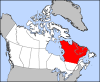
Peninsula
A peninsula is a piece of land that is bordered by water on three sides but connected to mainland. In many Germanic and Celtic languages and also in Baltic, Slavic and Hungarian, peninsulas are called "half-islands"....
in eastern Canada
Canada
Canada is a North American country consisting of ten provinces and three territories. Located in the northern part of the continent, it extends from the Atlantic Ocean in the east to the Pacific Ocean in the west, and northward into the Arctic Ocean...
. It is bounded by the Hudson Bay
Hudson Bay
Hudson Bay , sometimes called Hudson's Bay, is a large body of saltwater in northeastern Canada. It drains a very large area, about , that includes parts of Ontario, Quebec, Saskatchewan, Alberta, most of Manitoba, southeastern Nunavut, as well as parts of North Dakota, South Dakota, Minnesota,...
to the west, the Hudson Strait
Hudson Strait
Hudson Strait links the Atlantic Ocean to Hudson Bay in Canada. It lies between Baffin Island and the northern coast of Quebec, its eastern entrance marked by Cape Chidley and Resolution Island. It is long...
to the north, the Labrador Sea
Labrador Sea
The Labrador Sea is an arm of the North Atlantic Ocean between the Labrador Peninsula and Greenland. The sea is flanked by continental shelves to the southwest, northwest, and northeast. It connects to the north with Baffin Bay through the Davis Strait...
to the east, and the Gulf of Saint Lawrence
Gulf of Saint Lawrence
The Gulf of Saint Lawrence , the world's largest estuary, is the outlet of North America's Great Lakes via the Saint Lawrence River into the Atlantic Ocean...
to the south-east. The peninsula includes the region of Labrador
Labrador
Labrador is the distinct, northerly region of the Canadian province of Newfoundland and Labrador. It comprises the mainland portion of the province, separated from the island of Newfoundland by the Strait of Belle Isle...
, which is part of the province of Newfoundland and Labrador
Newfoundland and Labrador
Newfoundland and Labrador is the easternmost province of Canada. Situated in the country's Atlantic region, it incorporates the island of Newfoundland and mainland Labrador with a combined area of . As of April 2011, the province's estimated population is 508,400...
, and the regions of Saguenay-Lac-Saint-Jean
Saguenay-Lac-Saint-Jean
Saguenay–Lac-Saint-Jean is a region in Quebec, Canada. It contains the Saguenay Fjord, the estuary of the Saguenay River, stretching through much of the region...
, Côte-Nord
Côte-Nord
Côte-Nord is the second largest administrative region by land area in Quebec, Canada, after Nord-du-Québec...
, and Nord-du-Québec
Nord-du-Québec
Nord-du-Québec is the largest of the seventeen administrative regions of Quebec, Canada. With , of which are lakes and rivers, it covers much of the Labrador Peninsula and about 55% of the total land surface area of Quebec....
, which are in the province of Quebec
Quebec
Quebec or is a province in east-central Canada. It is the only Canadian province with a predominantly French-speaking population and the only one whose sole official language is French at the provincial level....
.It has an area of 1400000 km² (540,543 sq mi), and a population of about 150,000 (2006 census).
Location and geography
The peninsula is surrounded by sea from all sides except for the southwest where it connects to the mainland. The northern part of the Labrador Peninsula is shaped as a lesser peninsula, the Ungava PeninsulaUngava Peninsula
The Ungava Peninsula of Nunavik, Quebec, Canada, is bounded by Hudson Bay to the west, Hudson Strait to the north, and Ungava Bay to the east. The Ungava Peninsula is part of the Labrador Peninsula and covers about 252,000 km²...
, surrounded by the Hudson Bay, the Hudson Strait, and the Ungava Bay
Ungava Bay
Ungava Bay is a large bay in northeastern Canada separating Nunavik from Baffin Island. The bay is shaped like a rounded square with a side length of about and has an area of approximately...
. The northernmost point of the Ungava Peninsula, Cape Wolstenholme
Cape Wolstenholme
Cape Wolstenholme is the extreme northern-most point of the Canadian province of Quebec. Located on the Hudson Strait, about north-east of Quebec's northern-most settlement of Ivujivik, it is also the northern-most tip of the Ungava Peninsula, which is in turn the northern-most part of the...
, also serves as the northernmost point of the Labrador Peninsula and of the province of Quebec.
The peninsula is a plateau thread by river valleys. There are several mountain ranges. Torngat Mountains
Torngat Mountains
The Torngat Mountains are a mountain range on the Labrador Peninsula at the northern tip of Newfoundland and Labrador and eastern Quebec. They are part of the Arctic Cordillera. This is the peninsula that separates Ungava Bay from the Atlantic Ocean....
, located in the northern part of the peninsula, contain the highest point of the peninsula Mount Caubvick, with the height 1652 metres (5,419.9 ft) (which is accidentally the highest point of Canada east of Alberta
Alberta
Alberta is a province of Canada. It had an estimated population of 3.7 million in 2010 making it the most populous of Canada's three prairie provinces...
). The mountains also host Torngat Mountains National Park, the only national park of Canada on the Labrador Peninsula. The park is located in the province of Newfoundland and Labrador, whereas the adjacent Kuururjuaq National Park is governed by the province of Quebec.
History
The peninsula is named after Portuguese explorer João Fernandes LavradorJoão Fernandes Lavrador
João Fernandes Lavrador was a Portuguese explorer of the late 15th century. He was the first modern explorer in the coasts of the Northeast of Northern America, including the Labrador peninsula, which bears his name.-Expeditions:Fernandes was granted a patent by King Manuel I in 1498 given him...
. He was granted a patent by King Manuel I
Manuel I of Portugal
Manuel I , the Fortunate , 14th king of Portugal and the Algarves was the son of Infante Ferdinand, Duke of Viseu, , by his wife, Infanta Beatrice of Portugal...
of Portugal
Portugal
Portugal , officially the Portuguese Republic is a country situated in southwestern Europe on the Iberian Peninsula. Portugal is the westernmost country of Europe, and is bordered by the Atlantic Ocean to the West and South and by Spain to the North and East. The Atlantic archipelagos of the...
in 1499 which gave him the right to explore that part of the Atlantic Ocean as set out in the Treaty of Tordesillas
Treaty of Tordesillas
The Treaty of Tordesillas , signed at Tordesillas , , divided the newly discovered lands outside Europe between Spain and Portugal along a meridian 370 leagueswest of the Cape Verde islands...
.
Together with Pêro de Barcelos
Pêro de Barcelos
Pêro de Barcelos , sometimes Pedro de Barcelos, was a Portuguese explorer of North America, whom, together with João Fernandes Lavrador, was the first to sight the Coast of Labrador in 1499....
, he first sighted the province Labrador in 1498. Fernandes charted the coasts of Southwestern Greenland
Greenland
Greenland is an autonomous country within the Kingdom of Denmark, located between the Arctic and Atlantic Oceans, east of the Canadian Arctic Archipelago. Though physiographically a part of the continent of North America, Greenland has been politically and culturally associated with Europe for...
and of adjacent Northeastern North America around 1498 and gave notice of them in Portugal and Europe. His landowner status allowed him to use the title lavrador, Portuguese for "farmer" or "landholder" (lɐvɾɐˈðoɾ). Fernandes actually gave the name of Terra do Lavrador to Greenland which was the first land he sighted, but eventually the name was spread to all areas and finally was set for Labrador.