

Mount Katahdin
Encyclopedia
Mount Katahdin is the highest mountain in Maine
at 5268 feet (1,606 m). Named Katahdin by the Penobscot Indians, the term means "The Greatest Mountain". Katahdin is the centerpiece of Baxter State Park
: a steep, tall mountain formed from underground magma
. The flora and fauna on the mountain are typical of those found in northern New England. Katahdin was known to the Native Americans
in the region, and was known to Europeans at least since 1689. It has inspired hikes, climbs, paintings, and a piano sonata. The area around the peak was protected by Governor Percival Baxter
starting in the 1930s. Katahdin is the northern terminus of the Appalachian Trail
, and is located near a stretch known as the Hundred-Mile Wilderness.
, about 25 miles (40 km) northwest of Millinocket
. It is on the drainage divide between the East
and West branches
of the Penobscot River
and is the northern terminus of the Appalachian Trail.
The second highest point in Maine, Sugarloaf Mountain
at 1,295 m (4,250 ft) is over one hundred miles to the southwest. There is low lake country to the south and west of Katahdin, and lowlands extending east to the Atlantic and north to the Saint Lawrence River
in Canada.
It is commonly thought that Katahdin is the first place in the United States mainland to receive sunlight in the morning, but this is incorrect. Other mountains, lower in elevation but further to the east or southeast, depending on the season, see the first sunrise of the day.
(an intrusion of magma
underground) that formed in the Acadian orogeny
, when an island arc
collided with eastern North America
approximately 400 million years ago. On the sides of Katahdin are four glacial cirques
carved into the granite by alpine glacier
s and in these cirques behind moraine
s and esker
s are several picturesque ponds.
In Baxter State Park many outcrops of sedimentary rocks have striations, whereas Katahdin granite and Traveler rhyolite lava have weathered surfaces on which striations are commonly not preserved. Bedrock surfaces of igneous rocks which have been buried by glacial sediments and only recently exposed have well preserved striations, as in the vicinity of Ripogenus Dam. Several outcrops of sedimentary rocks along the Patten Road show striations, especially on the north side of the road at Hurricane Deck. A few outcrops near the Pattern Road just north of Horse Mountain are striated as are several outcrops of sedimentary rocks along the road from Trout Brook Farm northward to Second Lake Matagamon.
Fauna
include black bear
, deer
and moose
as well as black flies
and mosquito
s in the spring. Among the birds are Bicknell's Thrush
and various songbirds and raptors. The mountain has its own indigenous butterfly related to an Arctic type. The flora include pine
, spruce
, fir
, hemlock
, beech
, maple
, birch
, aspen
, and diapensia
.
 Katahdin is referred to 60 years after Field’s climb of Agiokochuk (Mount Washington
) in the writings of John Gyles
, a teenage colonist who was captured near Portland, Maine
in 1689 by the Abenaki. While in the company of Abenaki hunting parties, he traveled up and down several Maine rivers including both branches of the Penobscot
, passing close to “Teddon”. He remarked that it was higher than the White Hills
above the Saco River
.
Among some Native Americans
, Katahdin was believed to be the home of the storm god Pamola
, and thus an area to be avoided.
The first recorded climb of "Catahrdin" was by Massachusetts surveyor Charles Turner, Jr.
in August 1804. In the 1840s Henry David Thoreau
climbed Katahdin, which he spelled "Ktaadn"; his ascent is recorded in a well-known chapter of The Maine Woods. A few years later Theodore Winthrop
wrote about his visit in Life in the Open Air. Painters Frederic Edwin Church
and Marsden Hartley
are well-known artists who created landscapes of Katahdin.
In the 1930s Governor
Percival Baxter
began to acquire land and finally deeded more than 200,000 acre
s (809 km²) to the State of Maine for a park, named Baxter State Park
after him. The summit was officially recognized by the US Board on Geographic Names as "Baxter Peak" in 1931.
Because "Katahdin" means "Greatest Mountain", "Mount Katahdin" means "Mount Greatest Mountain", which local people maintain is incorrect, however the official name is Mount Katahdin as decided by the US Board on Geographic Names in 1893.

and southern terminus of the International Appalachian Trail
, Katahdin is a popular hiking and backpacking destination and the centerpiece of Baxter State Park
.
Baxter State Park is open year round, though strictly regulated in winter. The overnight camping season is from May 15 to October 15 each year. Capacity limits have been placed on day use parking at the trailheads to minimize the overuse of trails.
Maine
Maine is a state in the New England region of the northeastern United States, bordered by the Atlantic Ocean to the east and south, New Hampshire to the west, and the Canadian provinces of Quebec to the northwest and New Brunswick to the northeast. Maine is both the northernmost and easternmost...
at 5268 feet (1,606 m). Named Katahdin by the Penobscot Indians, the term means "The Greatest Mountain". Katahdin is the centerpiece of Baxter State Park
Baxter State Park
Baxter State Park is a large wilderness area permanently preserved as a state park, located in Piscataquis County in north-central Maine. The Park was established by 28 donations of land, in Trust, from Park donor Percival P. Baxter between the years of 1931 and 1962, eventually creating a Park of...
: a steep, tall mountain formed from underground magma
Laccolith
A laccolith is a sheet intrusion that has been injected between two layers of sedimentary rock. The pressure of the magma is high enough that the overlying strata are forced upward, giving the laccolith a dome or mushroom-like form with a generally planar base.Laccoliths tend to form at relatively...
. The flora and fauna on the mountain are typical of those found in northern New England. Katahdin was known to the Native Americans
Native Americans in the United States
Native Americans in the United States are the indigenous peoples in North America within the boundaries of the present-day continental United States, parts of Alaska, and the island state of Hawaii. They are composed of numerous, distinct tribes, states, and ethnic groups, many of which survive as...
in the region, and was known to Europeans at least since 1689. It has inspired hikes, climbs, paintings, and a piano sonata. The area around the peak was protected by Governor Percival Baxter
Percival P. Baxter
Percival Proctor Baxter was the 53rd Governor of the U.S. state of Maine who served from 1921 to 1925.-Early life:...
starting in the 1930s. Katahdin is the northern terminus of the Appalachian Trail
Appalachian Trail
The Appalachian National Scenic Trail, generally known as the Appalachian Trail or simply the AT, is a marked hiking trail in the eastern United States extending between Springer Mountain in Georgia and Mount Katahdin in Maine. It is approximately long...
, and is located near a stretch known as the Hundred-Mile Wilderness.
Geography
Katahdin is located in Baxter State Park, which is in east central Piscataquis CountyPiscataquis County, Maine
Piscataquis County is a county located in the U.S. state of Maine. In 2010, its population was 17,535, making it Maine's least-populous county. Its county seat is Dover-Foxcroft....
, about 25 miles (40 km) northwest of Millinocket
Millinocket, Maine
Millinocket is a former mill town in Penobscot County, Maine, United States. The population was 5,203 at the 2000 census. Millinocket is both a forest products and recreational area.-History:...
. It is on the drainage divide between the East
East Branch Penobscot River
The East Branch Penobscot River is a tributary of Maine's Penobscot River. From its source in Maine Township 7, Range 11, WELS, in Piscataquis County, the river runs southeast to Grand Lake Matagamon in the northeast corner of Baxter State Park...
and West branches
West Branch Penobscot River
The West Branch Penobscot River is a tributary of Maine's Penobscot River. The river flows from Seboomook Lake in Seboomook, Somerset County; the lake's principal inflows are the North Branch and South Branch Penobscot River...
of the Penobscot River
Penobscot River
The Penobscot River is a river in the U.S. state of Maine. Including the river's West Branch and South Branch increases the Penobscot's length to , making it the second longest river system in Maine and the longest entirely in the state. Its drainage basin contains .It arises from four branches...
and is the northern terminus of the Appalachian Trail.
The second highest point in Maine, Sugarloaf Mountain
Sugarloaf Mountain (Franklin County, Maine)
Sugarloaf Mountain is a mountain located in Franklin County, Maine. It is the second highest mountain in the state, after Mount Katahdin. Sugarloaf is flanked to the south by Spaulding Mountain....
at 1,295 m (4,250 ft) is over one hundred miles to the southwest. There is low lake country to the south and west of Katahdin, and lowlands extending east to the Atlantic and north to the Saint Lawrence River
Saint Lawrence River
The Saint Lawrence is a large river flowing approximately from southwest to northeast in the middle latitudes of North America, connecting the Great Lakes with the Atlantic Ocean. It is the primary drainage conveyor of the Great Lakes Basin...
in Canada.
It is commonly thought that Katahdin is the first place in the United States mainland to receive sunlight in the morning, but this is incorrect. Other mountains, lower in elevation but further to the east or southeast, depending on the season, see the first sunrise of the day.
Natural history
Katahdin is part of a laccolithLaccolith
A laccolith is a sheet intrusion that has been injected between two layers of sedimentary rock. The pressure of the magma is high enough that the overlying strata are forced upward, giving the laccolith a dome or mushroom-like form with a generally planar base.Laccoliths tend to form at relatively...
(an intrusion of magma
Magma
Magma is a mixture of molten rock, volatiles and solids that is found beneath the surface of the Earth, and is expected to exist on other terrestrial planets. Besides molten rock, magma may also contain suspended crystals and dissolved gas and sometimes also gas bubbles. Magma often collects in...
underground) that formed in the Acadian orogeny
Acadian orogeny
The Taconic, Acadian and Alleghenian orogenies are the three tectonic phases responsible for the formation of the present Appalachian Mountains. The Acadian orogeny is a middle Paleozoic mountain building episode dating back 325-400 million years which should not be regarded as a single event but...
, when an island arc
Island arc
An island arc is a type of archipelago composed of a chain of volcanoes which alignment is arc-shaped, and which are situated parallel and close to a boundary between two converging tectonic plates....
collided with eastern North America
North America
North America is a continent wholly within the Northern Hemisphere and almost wholly within the Western Hemisphere. It is also considered a northern subcontinent of the Americas...
approximately 400 million years ago. On the sides of Katahdin are four glacial cirques
Cirque (landform)
thumb|250 px|Two cirques with semi-permanent snowpatches in [[Abisko National Park]], [[Sweden]].A cirque or corrie is an amphitheatre-like valley head, formed at the head of a valley glacier by erosion...
carved into the granite by alpine glacier
Glacier
A glacier is a large persistent body of ice that forms where the accumulation of snow exceeds its ablation over many years, often centuries. At least 0.1 km² in area and 50 m thick, but often much larger, a glacier slowly deforms and flows due to stresses induced by its weight...
s and in these cirques behind moraine
Moraine
A moraine is any glacially formed accumulation of unconsolidated glacial debris which can occur in currently glaciated and formerly glaciated regions, such as those areas acted upon by a past glacial maximum. This debris may have been plucked off a valley floor as a glacier advanced or it may have...
s and esker
Esker
An esker is a long winding ridge of stratified sand and gravel, examples of which occur in glaciated and formerly glaciated regions of Europe and North America...
s are several picturesque ponds.
In Baxter State Park many outcrops of sedimentary rocks have striations, whereas Katahdin granite and Traveler rhyolite lava have weathered surfaces on which striations are commonly not preserved. Bedrock surfaces of igneous rocks which have been buried by glacial sediments and only recently exposed have well preserved striations, as in the vicinity of Ripogenus Dam. Several outcrops of sedimentary rocks along the Patten Road show striations, especially on the north side of the road at Hurricane Deck. A few outcrops near the Pattern Road just north of Horse Mountain are striated as are several outcrops of sedimentary rocks along the road from Trout Brook Farm northward to Second Lake Matagamon.
Fauna
Fauna
Fauna or faunæ is all of the animal life of any particular region or time. The corresponding term for plants is flora.Zoologists and paleontologists use fauna to refer to a typical collection of animals found in a specific time or place, e.g. the "Sonoran Desert fauna" or the "Burgess shale fauna"...
include black bear
American black bear
The American black bear is a medium-sized bear native to North America. It is the continent's smallest and most common bear species. Black bears are omnivores, with their diets varying greatly depending on season and location. They typically live in largely forested areas, but do leave forests in...
, deer
Deer
Deer are the ruminant mammals forming the family Cervidae. Species in the Cervidae family include white-tailed deer, elk, moose, red deer, reindeer, fallow deer, roe deer and chital. Male deer of all species and female reindeer grow and shed new antlers each year...
and moose
Moose
The moose or Eurasian elk is the largest extant species in the deer family. Moose are distinguished by the palmate antlers of the males; other members of the family have antlers with a dendritic configuration...
as well as black flies
Black fly
A black fly is any member of the family Simuliidae of the Culicomorpha infraorder. They are related to the Ceratopogonidae, Chironomidae, and Thaumaleidae. There are over 1,800 known species of black flies . Most species belong to the immense genus Simulium...
and mosquito
Mosquito
Mosquitoes are members of a family of nematocerid flies: the Culicidae . The word Mosquito is from the Spanish and Portuguese for little fly...
s in the spring. Among the birds are Bicknell's Thrush
Bicknell's Thrush
The Bicknell's Thrush, Catharus bicknelli, is a medium-sized thrush, at 17.5 cm and 28 g . It was named after Eugene Bicknell, an American amateur ornithologist, who discovered the species on Slide Mountain in the Catskills in the late 19th century.Adults are olive-brown on the upperparts,...
and various songbirds and raptors. The mountain has its own indigenous butterfly related to an Arctic type. The flora include pine
Pine
Pines are trees in the genus Pinus ,in the family Pinaceae. They make up the monotypic subfamily Pinoideae. There are about 115 species of pine, although different authorities accept between 105 and 125 species.-Etymology:...
, spruce
Spruce
A spruce is a tree of the genus Picea , a genus of about 35 species of coniferous evergreen trees in the Family Pinaceae, found in the northern temperate and boreal regions of the earth. Spruces are large trees, from tall when mature, and can be distinguished by their whorled branches and conical...
, fir
Fir
Firs are a genus of 48–55 species of evergreen conifers in the family Pinaceae. They are found through much of North and Central America, Europe, Asia, and North Africa, occurring in mountains over most of the range...
, hemlock
Eastern Hemlock
Tsuga canadensis, also known as eastern or Canadian hemlock, and in the French-speaking regions of Canada as pruche du Canada, is a coniferous tree native to eastern North America. It ranges from northeastern Minnesota eastward through southern Quebec to Nova Scotia, and south in the Appalachian...
, beech
Beech
Beech is a genus of ten species of deciduous trees in the family Fagaceae, native to temperate Europe, Asia and North America.-Habit:...
, maple
Maple
Acer is a genus of trees or shrubs commonly known as maple.Maples are variously classified in a family of their own, the Aceraceae, or together with the Hippocastanaceae included in the family Sapindaceae. Modern classifications, including the Angiosperm Phylogeny Group system, favour inclusion in...
, birch
Birch
Birch is a tree or shrub of the genus Betula , in the family Betulaceae, closely related to the beech/oak family, Fagaceae. The Betula genus contains 30–60 known taxa...
, aspen
Aspen
Populus section Populus, of the Populus genus, includes the aspen trees and the white poplar Populus alba. The five typical aspens are all native to cold regions with cool summers, in the north of the Northern Hemisphere, extending south at high altitudes in the mountains. The White Poplar, by...
, and diapensia
Diapensia
Diapensia lapponica is a plant in the family Diapensiaceae, the only circumpolar species in the genus Diapensia, the others being mainly in the Himalayas. It is a circumboreal arctic-alpine species which grows on exposed rocky ridges that are kept free from snow by high winds .It is a small...
.
Human history
Mount Washington (New Hampshire)
Mount Washington is the highest peak in the Northeastern United States at , famous for dangerously erratic weather. For 76 years, a weather observatory on the summit held the record for the highest wind gust directly measured at the Earth's surface, , on the afternoon of April 12, 1934...
) in the writings of John Gyles
John Gyles
John Gyles was an interpreter and soldier, most known for his account of his experiences with the Malecite tribes of the Saint John River....
, a teenage colonist who was captured near Portland, Maine
Portland, Maine
Portland is the largest city in Maine and is the county seat of Cumberland County. The 2010 city population was 66,194, growing 3 percent since the census of 2000...
in 1689 by the Abenaki. While in the company of Abenaki hunting parties, he traveled up and down several Maine rivers including both branches of the Penobscot
Penobscot River
The Penobscot River is a river in the U.S. state of Maine. Including the river's West Branch and South Branch increases the Penobscot's length to , making it the second longest river system in Maine and the longest entirely in the state. Its drainage basin contains .It arises from four branches...
, passing close to “Teddon”. He remarked that it was higher than the White Hills
White Mountains (New Hampshire)
The White Mountains are a mountain range covering about a quarter of the state of New Hampshire and a small portion of western Maine in the United States. Part of the Appalachian Mountains, they are considered the most rugged mountains in New England...
above the Saco River
Saco River
The Saco River is a river in northeastern New Hampshire and southwestern Maine in the United States. It drains a rural area of of forests and farmlands west and southwest of Portland, emptying into the Atlantic Ocean at Saco Bay, from its source. It supplies drinking water to roughly 250,000...
.
Among some Native Americans
Native Americans in the United States
Native Americans in the United States are the indigenous peoples in North America within the boundaries of the present-day continental United States, parts of Alaska, and the island state of Hawaii. They are composed of numerous, distinct tribes, states, and ethnic groups, many of which survive as...
, Katahdin was believed to be the home of the storm god Pamola
Pamola
Pamola is a legendary bird spirit that appears in Abenaki mythology. This spirit causes cold weather....
, and thus an area to be avoided.
The first recorded climb of "Catahrdin" was by Massachusetts surveyor Charles Turner, Jr.
Charles Turner, Jr.
Charles Turner, Jr. was a U.S. Representative from Massachusetts.Born in Duxbury, Massachusetts, Turner received a common-school education at Duxbury and Scituate, Massachusetts. He was commissioned an adjutant in the Massachusetts State Militia in 1787...
in August 1804. In the 1840s Henry David Thoreau
Henry David Thoreau
Henry David Thoreau was an American author, poet, philosopher, abolitionist, naturalist, tax resister, development critic, surveyor, historian, and leading transcendentalist...
climbed Katahdin, which he spelled "Ktaadn"; his ascent is recorded in a well-known chapter of The Maine Woods. A few years later Theodore Winthrop
Theodore Winthrop
Theodore Winthrop was a writer, lawyer, and world traveller. He was one of the first Union officers killed in the American Civil War.-Biography:...
wrote about his visit in Life in the Open Air. Painters Frederic Edwin Church
Frederic Edwin Church
Frederic Edwin Church was an American landscape painter born in Hartford, Connecticut. He was a central figure in the Hudson River School of American landscape painters...
and Marsden Hartley
Marsden Hartley
Marsden Hartley was an American Modernist painter, poet, and essayist.-Early life and education:Hartley was born in Lewiston, Maine, where his English parents had settled. He was the youngest of nine children. His mother died when he was eight, and his father remarried four years later to Martha...
are well-known artists who created landscapes of Katahdin.
In the 1930s Governor
Governor of Maine
The governor of Maine is the chief executive of the State of Maine. Before Maine was admitted to the Union in 1820, Maine was part of Massachusetts and the governor of Massachusetts was chief executive....
Percival Baxter
Percival P. Baxter
Percival Proctor Baxter was the 53rd Governor of the U.S. state of Maine who served from 1921 to 1925.-Early life:...
began to acquire land and finally deeded more than 200,000 acre
Acre
The acre is a unit of area in a number of different systems, including the imperial and U.S. customary systems. The most commonly used acres today are the international acre and, in the United States, the survey acre. The most common use of the acre is to measure tracts of land.The acre is related...
s (809 km²) to the State of Maine for a park, named Baxter State Park
Baxter State Park
Baxter State Park is a large wilderness area permanently preserved as a state park, located in Piscataquis County in north-central Maine. The Park was established by 28 donations of land, in Trust, from Park donor Percival P. Baxter between the years of 1931 and 1962, eventually creating a Park of...
after him. The summit was officially recognized by the US Board on Geographic Names as "Baxter Peak" in 1931.
Because "Katahdin" means "Greatest Mountain", "Mount Katahdin" means "Mount Greatest Mountain", which local people maintain is incorrect, however the official name is Mount Katahdin as decided by the US Board on Geographic Names in 1893.
Recreation opportunities
As the northern terminus of the Appalachian TrailAppalachian Trail
The Appalachian National Scenic Trail, generally known as the Appalachian Trail or simply the AT, is a marked hiking trail in the eastern United States extending between Springer Mountain in Georgia and Mount Katahdin in Maine. It is approximately long...
and southern terminus of the International Appalachian Trail
International Appalachian Trail
The International Appalachian Trail is a hiking trail which runs from the northern terminus of the Appalachian Trail at Mount Katahdin, Maine, through New Brunswick, to the Gaspé Peninsula of Quebec, after which it takes bridge crossings to Nova Scotia and Prince Edward Island, a ferry ride to...
, Katahdin is a popular hiking and backpacking destination and the centerpiece of Baxter State Park
Baxter State Park
Baxter State Park is a large wilderness area permanently preserved as a state park, located in Piscataquis County in north-central Maine. The Park was established by 28 donations of land, in Trust, from Park donor Percival P. Baxter between the years of 1931 and 1962, eventually creating a Park of...
.
Baxter State Park is open year round, though strictly regulated in winter. The overnight camping season is from May 15 to October 15 each year. Capacity limits have been placed on day use parking at the trailheads to minimize the overuse of trails.
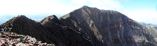
Knife Edge
The most famous hike to the summit goes along Knife Edge, which traverses the ridge between Pamola Peak and Baxter Peak. The mountain has claimed 19 lives since 1963, mostly from exposure in bad weather and falls from the Knife Edge. For about 3/10 of a mile the trail is 3 feet wide, with a drop off on either side. The Knife Edge is closed during periods of high wind.Other references
- Two US Navy ships have been named USS KatahdinUSS KatahdinTwo vessels of the United States Navy have been named USS Katahdin, after Mount Katahdin., was a screw gunboat commissioned in early 1862, active throughout the American Civil War, and decommissioned shortly after war's end...
after the mountain. Katahdin is also the name of a 1914 steamboatSteamboatA steamboat or steamship, sometimes called a steamer, is a ship in which the primary method of propulsion is steam power, typically driving propellers or paddlewheels...
(later converted to dieselDiesel engineA diesel engine is an internal combustion engine that uses the heat of compression to initiate ignition to burn the fuel, which is injected into the combustion chamber...
) owned by the Moosehead Marine Museum that plies the waters of Moosehead LakeMoosehead LakeMoosehead Lake is the largest lake in the U.S. state of Maine and the largest mountain lake in the eastern United States. Situated in the Longfellow Mountains in the Maine Highlands Region, the lake is the source of the Kennebec River. Towns that border the lake include Greenville to the south and...
in northern MaineMaineMaine is a state in the New England region of the northeastern United States, bordered by the Atlantic Ocean to the east and south, New Hampshire to the west, and the Canadian provinces of Quebec to the northwest and New Brunswick to the northeast. Maine is both the northernmost and easternmost...
.
See also
- List of mountains in Maine
- Mountain peaks of North AmericaMountain peaks of North AmericaThis article comprises three sortable tables of major mountain peaks of greater North America.This article defines greater North America as the portion of the continental landmass of the Americas extending northward from Panama plus the islands surrounding that landmass...
- Mountain peaks of the United StatesMountain peaks of the United StatesThis article comprises three sortable tables of the major mountain peaks of the United States of America.Topographic elevation is the vertical distance above the reference geoid, a precise mathematical model of the Earth's sea level as an equipotential gravitational surface...