Ilm-Kreis
Encyclopedia
Ilm-Kreis is a district in Thuringia
, Germany
. It is bounded by (from the north and clockwise) the city of Erfurt
, the districts of Weimarer Land
, Saalfeld-Rudolstadt
and Hildburghausen
, the city of Suhl
, and the districts of Schmalkalden-Meiningen
and Gotha
. It is named after the river Ilm
, flowing through the district.
and the princes of Schwarzburg
, two local dynasties. While Ilmenau
was ruled by Henneberg, Arnstadt belonged to Schwarzburg. When the Henneberg family became extinct in 1583, Ilmenau was acquired by Saxony
. In the meantime the principality of Schwarzburg began to disintegrate and was split up in several tiny states. One of those states (Schwarzburg-Arnstadt) was based in Arnstadt; it was founded in 1574 and existed until 1716, when it fell to Schwarzburg-Sondershausen. This mini state existed until 1920, when the state of Thuringia was founded.
The district was founded in 1920 (under the name Arnstadt); it was divided in 1952 into the districts of Arnstadt and Ilmenau, but reunited in 1994.
, among them the highest elevation of that mountain chain, including the Großer Beerberg (982 m). To the north the country is sloping away and becomes rather plain, mainly agricultural area.

Thuringia
The Free State of Thuringia is a state of Germany, located in the central part of the country.It has an area of and 2.29 million inhabitants, making it the sixth smallest by area and the fifth smallest by population of Germany's sixteen states....
, Germany
Germany
Germany , officially the Federal Republic of Germany , is a federal parliamentary republic in Europe. The country consists of 16 states while the capital and largest city is Berlin. Germany covers an area of 357,021 km2 and has a largely temperate seasonal climate...
. It is bounded by (from the north and clockwise) the city of Erfurt
Erfurt
Erfurt is the capital city of Thuringia and the main city nearest to the geographical centre of Germany, located 100 km SW of Leipzig, 150 km N of Nuremberg and 180 km SE of Hannover. Erfurt Airport can be reached by plane via Munich. It lies in the southern part of the Thuringian...
, the districts of Weimarer Land
Weimarer Land
Weimarer Land is a Kreis in the east of Thuringia, Germany. Neighboring districts are the district Burgenlandkreis in Saxony-Anhalt, the district Saale-Holzland and the district-free city Jena, the district Saalfeld-Rudolstadt, Ilm-Kreis, and the district-free city Erfurt...
, Saalfeld-Rudolstadt
Saalfeld-Rudolstadt
Saalfeld-Rudolstadt is a Kreis in the south of Thuringia, Germany. Neighboring districts are the districts Weimarer Land, Saale-Holzland, Saale-Orla, the district Kronach in Bavaria, and the districts Sonneberg, Hildburghausen and Ilm-Kreis.-History:The district dates back to the Landratsamt...
and Hildburghausen
Hildburghausen (district)
Hildburghausen is a district in Thuringia, Germany. It is bounded by the district of Schmalkalden-Meiningen, the city of Suhl, the districts of Ilm-Kreis, Saalfeld-Rudolstadt and Sonneberg, and the state of Bavaria...
, the city of Suhl
Suhl
- Geography :Suhl sits on the south edge of the Suhler Scholle, an upthrust granite complex that is streaked by numerous dikes. This is part of the Ruhla-Schleusingen Horst that defines the southwest side of the Thuringian Forest...
, and the districts of Schmalkalden-Meiningen
Schmalkalden-Meiningen
Schmalkalden-Meiningen is a Landkreis in the west of Thuringia, Germany. Its neighboring districts are the districts Wartburgkreis, Gotha, Ilm-Kreis, the district-free city Suhl, the district Hildburghausen, the Bavarian district Rhön-Grabfeld, and the district Fulda in Hesse.- History :The...
and Gotha
Gotha (district)
Gotha is a Kreis in the middle of Thuringia, Germany. Neighboring districts are Unstrut-Hainich, Sömmerda, the district-free city Erfurt, Ilm-Kreis, Schmalkalden-Meiningen and the Wartburgkreis.-History:...
. It is named after the river Ilm
Ilm (Thuringia)
The Ilm is a long river in Thuringia, Germany. It is a left tributary of the Saale, into which it flows in Großheringen near Bad Kösen.Towns along the Ilm are Ilmenau, Stadtilm, Kranichfeld, Bad Berka, Weimar, Apolda and Bad Sulza....
, flowing through the district.
History
In medieval times the territory was ruled by the counts of HennebergHenneberg
Henneberg may refer to:*the House of Henneberg, German nobility*County of Henneberg, a mediæval state in the Holy Roman Empire*Henneberg, Thuringia, a municipality in Thuringia, Germany*Mary Jane Henneberg, b. 1973, TV reporter...
and the princes of Schwarzburg
Schwarzburg
Schwarzburg is a municipality in the valley of the Schwarza in the district Saalfeld-Rudolstadt in Thuringia, Germany.First mentioned in 1071 as Swartzinburg. The castle was from the 12th century the seat of the Counts of Schwarzburg...
, two local dynasties. While Ilmenau
Ilmenau
Ilmenau is a town located in the district of Ilm-Kreis, Thuringia, Germany.Ilmenau is situated in the valley of the Ilm river, at an altitude of 431 metres above sea level, and is the biggest town in Ilm-Kreis district, with 6,200 students studying at the Technische Universität Ilmenau. The...
was ruled by Henneberg, Arnstadt belonged to Schwarzburg. When the Henneberg family became extinct in 1583, Ilmenau was acquired by Saxony
Saxony
The Free State of Saxony is a landlocked state of Germany, contingent with Brandenburg, Saxony Anhalt, Thuringia, Bavaria, the Czech Republic and Poland. It is the tenth-largest German state in area, with of Germany's sixteen states....
. In the meantime the principality of Schwarzburg began to disintegrate and was split up in several tiny states. One of those states (Schwarzburg-Arnstadt) was based in Arnstadt; it was founded in 1574 and existed until 1716, when it fell to Schwarzburg-Sondershausen. This mini state existed until 1920, when the state of Thuringia was founded.
The district was founded in 1920 (under the name Arnstadt); it was divided in 1952 into the districts of Arnstadt and Ilmenau, but reunited in 1994.
Geography
In its southern portions the district includes parts of the southeastern Thuringian ForestThuringian Forest
The Thuringian Forest running northwest to southeast, forms a continuous stretch of ancient rounded mountains posing ample difficulties in transit routing save through a few navigable passes in the southern reaches of the German state of Thuringia. It is about long and wide...
, among them the highest elevation of that mountain chain, including the Großer Beerberg (982 m). To the north the country is sloping away and becomes rather plain, mainly agricultural area.
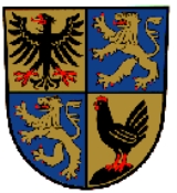
Coat of arms
 |
The coat of arms displays:
|
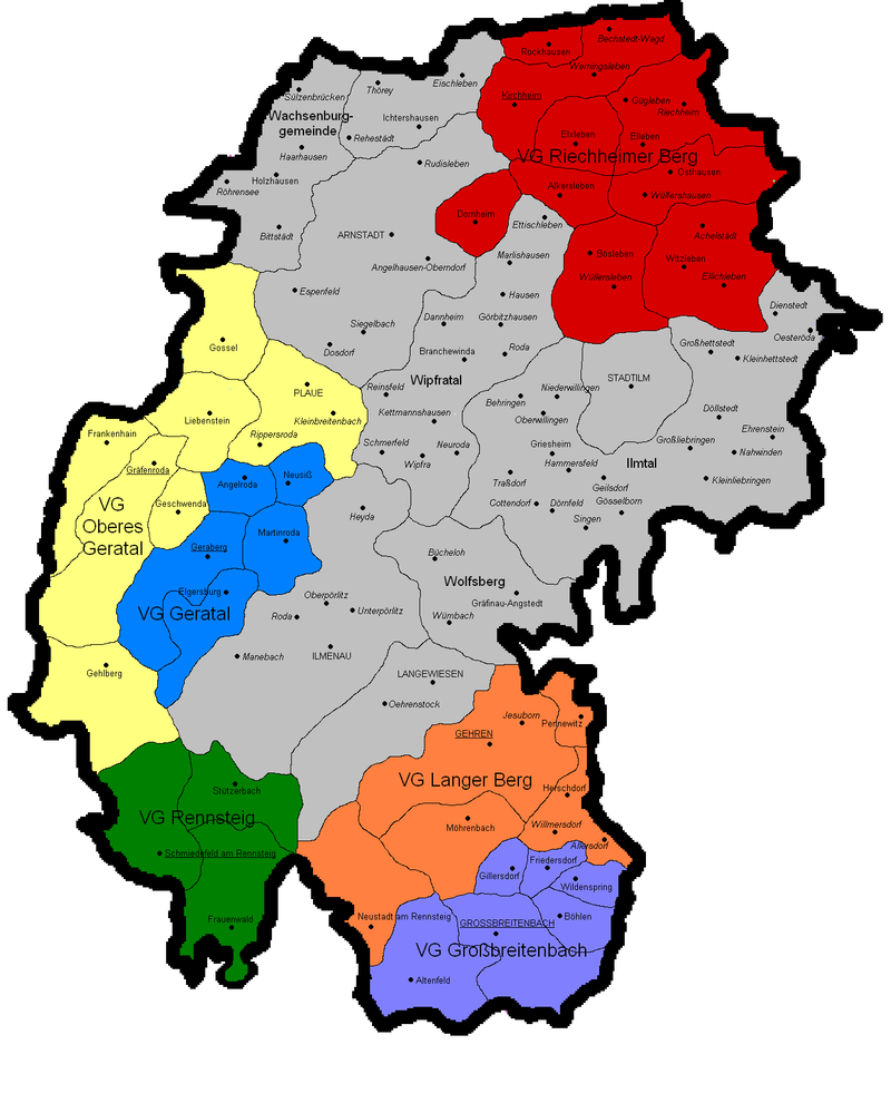
Towns and municipalities
| Verwaltungsgemeinschaft-free towns | and municipalities |
|---|---|
|
Ichtershausen Ichtershausen is a municipality in the district Ilm-Kreis, in Thuringia, Germany.... Ilmtal Ilmtal is a municipality in the district Ilm-Kreis, in Thuringia, Germany.... Wachsenburggemeinde Wachsenburggemeinde is a municipality in the district Ilm-Kreis, in Thuringia, Germany. The municipality is named after the castle Veste Wachsenburg which is located in its center. It consists of the five villages named Bittstädt, Haarhausen, Holzhausen, Röhrensee, and Sülzenbrücken.... Wipfratal Wipfratal is a municipality in the district Ilm-Kreis, in Thuringia, Germany.... Wolfsberg, Thuringia Wolfsberg is a municipality in the district Ilm-Kreis, in Thuringia, Germany.... |
| Verwaltungsgemeinschaften | ||
|---|---|---|
|
1. Geratal Geratal Geratal is a Verwaltungsgemeinschaft in the district Ilm-Kreis, in Thuringia, Germany. The seat of the Verwaltungsgemeinschaft is in Geraberg.The Verwaltungsgemeinschaft Geratal consists of the following municipalities:...
2. Großbreitenbach Großbreitenbach (Verwaltungsgemeinschaft) Großbreitenbach is a Verwaltungsgemeinschaft in the district Ilm-Kreis, in Thuringia, Germany. The seat of the Verwaltungsgemeinschaft is in Großbreitenbach....
|
3. Langer Berg Langer Berg Langer Berg is a Verwaltungsgemeinschaft in the district Ilm-Kreis, in Thuringia, Germany. The seat of the Verwaltungsgemeinschaft is in Gehren....
4. Oberes Geratal Oberes Geratal Oberes Geratal is a Verwaltungsgemeinschaft in the district Ilm-Kreis, in Thuringia, Germany. The seat of the Verwaltungsgemeinschaft is in Gräfenroda....
|
5. Rennsteig Rennsteig (Verwaltungsgemeinschaft) Rennsteig is a Verwaltungsgemeinschaft in the district Ilm-Kreis, in Thuringia, Germany. The seat of the Verwaltungsgemeinschaft is in Schmiedefeld am Rennsteig....
6. Riechheimer Berg Riechheimer Berg Riechheimer Berg is a Verwaltungsgemeinschaft in the district Ilm-Kreis, in Thuringia, Germany. The seat of the Verwaltungsgemeinschaft is in Kirchheim....
|
| 1seat of the Verwaltungsgemeinschaft;2town | ||

External links
- Official website (German, English)

