
Rhön Mountains
Encyclopedia
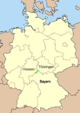
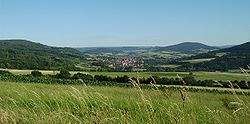
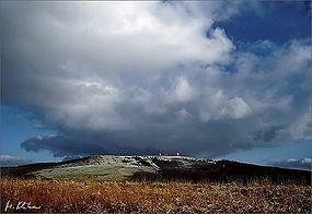
The Rhön Mountains are a group of low mountains in central Germany
, located around the border area where the states of Hesse
, Bavaria
and Thuringia
come together. These mountains, which are at the extreme southeast end of the East Hesse Highlands
(Osthessisches Bergland), are partly a result of ancient volcanic
activity. They are separated from the Vogelsberg Mountains
by the Fulda River
and its valley. The highest mountain in the Rhön is the Wasserkuppe
(950.2 m) which is in Hesse
. The Rhön Mountains are a popular tourist destination and walking area.
 The name Rhön is often thought to derive from the Celtic word raino (=hilly), but numerous other interpretations are also possible. Records of the monks at Fulda
from the middle ages
describe the area around Fulda as well as more distant parts of the Rhön as Buchonia
, the land of ancient beech woods. In the Middle Ages beech was an important raw material. Large scale wood clearing resulted in the "land of open spaces" (Land der offenen Fernen), 30% of which, today, is forested.

 Lying within the aforementioned states, the Rhön is bounded by the Knüll
to the northwest, the Thuringian Forest
to the northeast, the Grabfeld
to the southeast, Lower Franconia
to the south, the Spessart
forest to the southwest and the Vogelsberg mountains
to the west.
(354, "High Rhön").
Vorderer Rhön also consists mainly of Kuppen or low mountains with dome-shaped summits. The name has genuine historic origins: the Vorderer Rhön, as viewed from Thuringia, forms the foothills or "front" (vorne) of the mountain region.
In this gently rolling landscape numerous individual dome-shaped mountains rise on both sides of the border of Hesse and Thuringia and also, in some places, in Bavaria. These Kuppen are the remnants of former volcanos or volcanic
Five mountain regions may be distinguished:
 The Hohe Rhön
(or Hochrhön) extends into all 3 states and is bounded by the Vorderer Rhön in the northeast, the Grabfeld
in the southeast, the Spessart
in the southwest and the Kuppenrhön in the northwest. It also has five main mountainous regions:
 The most well-known peaks in the Rhön Mountains include the:
 The name Rhön is believed to be of Celtic origin. Evidence of this is the Celtic settlement of Milseburg
where there was a Celtic town with 1000 inhabitants. Furthermore there are circular embankments that could be both of Celtic and of Germanic origin in the Kuppenrhön on the Stallberg and the Kleinberg mountains. Many names of places, mountains and meadows in the Rhön have their origins in Celtic root words.
Up to the 10th century parts of the Rhön belonged to Altgau Buchonia
. This term was coined by the Romans in Late Antiquity
and described an ancient beech forest in the Rhön and the neighbouring low mountain ranges of the Spessart
and Vogelsberg
. Expansive stands of beech still exist today in the area.
Due to the outstanding field of view from the Rhön mountains, they became sites for hilltop castles in the Middle Ages
. One example is Hauneck Castle (Burg Hauneck) on the Stoppelsberg
, the ruins of which can still be seen. It served to oversee and protect traffic on the ancient road, the Antsanvia, as well as protecting the villages in the Haune Valley.
In the Middle Ages the Würzburg Defences (Landwehr) were erected on the Hochrhön for the protection of its farmers.
declared the Rhön a Biosphere Reserve
on account of its unique high-altitude ecosystem.
. But man, too, has generated valuable secondary habitats by creating a rich cultural landscape.

 Compared with other low mountain regions, the Rhön is particularly rich in plant varieties. Its natural vegetation would probably be dominated by beech
woods with scattered groups of other trees, but today beech trees are very much in decline. A few of these ancient woods were identified as core elements of the Rhön biosphere reserve. The higher beech woods are a habitat for rare, sometimes isolated, species of plant such as the Alpine Blue-sow-thistle, Giant bellflower
and Annual honesty
. The vegetation of the lower-lying beech woods has a mix of mountain and other varieties. In addition to common wildflowers like the Martagon lily, Lily of the Valley
, Wild Chervil and Wild Garlic, various orchids also flourish here including Cephalanthera
orchids, the Yellow Coralroot, Bird's-nest Orchid
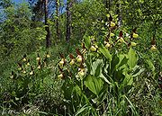
, Lady's Slipper
and Lady orchid
.
Only small areas of the Rhön landscape are essentially open: the high-moor bog
s, the rock outcrops and the stone runs. These habitats are home to highly-specialised species. The high-moor bogs of the Langen Rhön - the Red Moor (Rotes Moor) and the Black Moor (Schwarzes Moor) are floristically important important links between the northern and Alpine high moors. Here, for example, can be found sundew
s, crowberry
and cottongrass. Growing amongst the rocks of the volcanic mountains are rare species such as Cheddar Pink, Sweet William Catchfly
, Oblong Woodsia and Fir Clubmoss.
There are no naturally-occurring coniferous forests in the Rhön, but notable species of wild flower such as the Lady's Slipper Orchid
, Creeping Lady's Tresses and Burning-bush are found in the forests of mixed pine.
The cultural landscape formed by mankind over the centuries also has a great variety of habitats and plants however, today, the extensive grassland areas are amongst the most threatened and heavily cultivated habitats. It is on the semi-arid grassland
s and juniper
heaths that the Silver Thistle, symbol of the Rhön region, grows, alongside gentian
s, Pasque Flower
s and Wood Anemone
s, as well as orchids like the Early Purple
, Fragrant
and Fly Orchid
s. Rarer flowers include the various Bee orchid
s and the Military
, Lady
, Burnt
, Green-winged
, Man
, Pyramidal
, Frog
and Lizard Orchid
s. Along the southern fringes of the Rhön, on the so-called slopes of steppe heathland (Steppenheidenhängen) grow warmth-loving plants such as White Rock-rose, Erect Clematis and Honewort.
Amongst the most valuable habitats in the Rhön are the mountain meadows and fields of mat grass (Nardetum strictae) on the higher slopes. Characteristic plants here include the Monkshood, Northern Wolfsbane
, Common Moonwort, Martagon Lily, Greater Butterfly Orchid, Perennial Cornflower and Wig Knapweed.
Bog-bean, Grass of Parnassus
' Western Marsh Orchid
and Lousewort
are found in the wet meadows and low marshes; and the extremely rare Large Brown Clover, Hairy Stonecrop and Pyrenean scurvygrass in the springwater marshes of the Hohe Rhön.
.jpg)
, fox
, badger, hare
and wild boar, there are also smaller mammals such as the dormouse
, common water shrew
and Miller's water shrew
. One unusual regional species is the alpine shrew
. Birds occurring here include the black grouse
, the capercaillie
, the black stork
, the eagle owl, the corncrake, the red-backed shrike
and the wryneck
. There are also two species endemic to the Rhön: the rove beetle
and a local snail, the Rhönquellschnecke (Bythinella compressa).
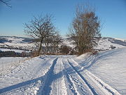
come for the nearly 6000 km (3,728.2 mi) of trails through the picturesque scenery, and gliding
enthusiasts have been drawn to the area since the early Twentieth century. More recently, farm holidays have been flourishing in the region.
 {|
{|
| width="185" valign="top" |
| width="185" valign="top" |
| width="185" valign="top" |
|}
{|
| width="185" valign="top" |
| width="185" valign="top" |
| width="185" valign="top" |
|}
 There are well-marked walks and hiking trails in the Rhön which are looked after by the Rhön Hiking Club (the Rhönklub). Among the most impressive is the Rhön-Höhen-Weg ("Rhön Heights Walk" or RHW) which is marked with a horizontal, red teardrop. It is 137 km long and runs from Burgsinn
in Main-Spessart
district through Roßbach, Dreistelz, Würzburger Haus on the Farnsberg, Kissinger Hütte on the Feuerberg, Kreuzberg (monastery
), Oberweißenbrunn, through the Red and Black Moors, over the Ellenbogen and the Emberg via Oberalba, past Baier to Stadtlengsfeld
and on to its destination at Bad Salzungen
on the Werra
River.
Also highly recommended are:
In addition the following run through the Rhön:
rhoen
Germany
Germany , officially the Federal Republic of Germany , is a federal parliamentary republic in Europe. The country consists of 16 states while the capital and largest city is Berlin. Germany covers an area of 357,021 km2 and has a largely temperate seasonal climate...
, located around the border area where the states of Hesse
Hesse
Hesse or Hessia is both a cultural region of Germany and the name of an individual German state.* The cultural region of Hesse includes both the State of Hesse and the area known as Rhenish Hesse in the neighbouring Rhineland-Palatinate state...
, Bavaria
Bavaria
Bavaria, formally the Free State of Bavaria is a state of Germany, located in the southeast of Germany. With an area of , it is the largest state by area, forming almost 20% of the total land area of Germany...
and Thuringia
Thuringia
The Free State of Thuringia is a state of Germany, located in the central part of the country.It has an area of and 2.29 million inhabitants, making it the sixth smallest by area and the fifth smallest by population of Germany's sixteen states....
come together. These mountains, which are at the extreme southeast end of the East Hesse Highlands
East Hesse Highlands
The East Hesse Highlands describes a heavily wooded range of hills lying mainly in the German state of Hesse, but also extending a little way into Lower Saxony to the north, Thuringia to the east and Bavaria to the southeast...
(Osthessisches Bergland), are partly a result of ancient volcanic
Volcano
2. Bedrock3. Conduit 4. Base5. Sill6. Dike7. Layers of ash emitted by the volcano8. Flank| 9. Layers of lava emitted by the volcano10. Throat11. Parasitic cone12. Lava flow13. Vent14. Crater15...
activity. They are separated from the Vogelsberg Mountains
Vogelsberg Mountains
The Vogelsberg Mountains are a group duct of ancient volcanic activity and are separated from the Rhön Mountains by the Fulda River and its valley....
by the Fulda River
Fulda River
The Fulda is a river in Hesse, Germany. It is one of two headstreams of the Weser . The Fulda is 218 km in length....
and its valley. The highest mountain in the Rhön is the Wasserkuppe
Wasserkuppe
The Wasserkuppe is a high plateau , the highest peak in the Rhön Mountains within the German state of Hessen. Between the first and second World Wars, during the era of the so-called Golden Age of Aviation, great advances in sailplane development were made there.Remark: The German wording takes its...
(950.2 m) which is in Hesse
Hesse
Hesse or Hessia is both a cultural region of Germany and the name of an individual German state.* The cultural region of Hesse includes both the State of Hesse and the area known as Rhenish Hesse in the neighbouring Rhineland-Palatinate state...
. The Rhön Mountains are a popular tourist destination and walking area.
Origins
Fulda
Fulda is a city in Hesse, Germany; it is located on the river Fulda and is the administrative seat of the Fulda district .- Early Middle Ages :...
from the middle ages
Middle Ages
The Middle Ages is a periodization of European history from the 5th century to the 15th century. The Middle Ages follows the fall of the Western Roman Empire in 476 and precedes the Early Modern Era. It is the middle period of a three-period division of Western history: Classic, Medieval and Modern...
describe the area around Fulda as well as more distant parts of the Rhön as Buchonia
Buchonia
Buchonia is a region in Hesse, a state of Germany, where one of the first forestry planning systems was developed by Georg Ludwig Hartig . It was called "Flächenfachwerk". He also wrote in 1791 "Anweisung zur Holzzucht für Förster"-Books:...
, the land of ancient beech woods. In the Middle Ages beech was an important raw material. Large scale wood clearing resulted in the "land of open spaces" (Land der offenen Fernen), 30% of which, today, is forested.
Location
Knüll
Knüllgebirge or Knüll is a small mountain range in Hesse, Germany. It is located in the Northern part of Hesse approximately 45 km South of Kassel, its highest peak is the Eisenberg having an altitude of 636 m. Its area has a rather low population density and is heavily forested...
to the northwest, the Thuringian Forest
Thuringian Forest
The Thuringian Forest running northwest to southeast, forms a continuous stretch of ancient rounded mountains posing ample difficulties in transit routing save through a few navigable passes in the southern reaches of the German state of Thuringia. It is about long and wide...
to the northeast, the Grabfeld
Grabfeld
The Grabfeld is a region in Germany, on the border between Bavaria and Thuringia. It is situated southeast of the Rhön Mountains. Its highest elevation is 679 m . The Grabfeld gave its name to the Bavarian district Rhön-Grabfeld and the Thuringian municipality Grabfeld....
to the southeast, Lower Franconia
Lower Franconia
Lower Franconia is one of the three administrative regions of Franconia in Bavaria , Germany ....
to the south, the Spessart
Spessart
The Spessart is a low mountain range in northwestern Bavaria and southern Hesse, Germany. It is bordered on three sides by the Main River. The two most important towns located at the foot of the Spessart are Aschaffenburg and Würzburg....
forest to the southwest and the Vogelsberg mountains
Vogelsberg Mountains
The Vogelsberg Mountains are a group duct of ancient volcanic activity and are separated from the Rhön Mountains by the Fulda River and its valley....
to the west.
Division by type of volcanic activity
Thanks to former volcanic activity the Rhön can be divided into the Vorderer Rhön (Vorderrhön or "Rhön foothills"), the Kuppenrhön (geographical region 353, "Kuppen Rhön") and the Hohe RhönHohe Rhön
Hohe Rhön is a Verwaltungsgemeinschaft in the district Schmalkalden-Meiningen, in Thuringia, Germany. The seat of the Verwaltungsgemeinschaft is in Kaltensundheim....
(354, "High Rhön").
Vorderrhön and Kuppenrhön
The terms Vorderer Rhön (Vorderrhön) and Kuppenrhön (Kuppiger Rhön) are somewhat misleading, since theVorderer Rhön also consists mainly of Kuppen or low mountains with dome-shaped summits. The name has genuine historic origins: the Vorderer Rhön, as viewed from Thuringia, forms the foothills or "front" (vorne) of the mountain region.
In this gently rolling landscape numerous individual dome-shaped mountains rise on both sides of the border of Hesse and Thuringia and also, in some places, in Bavaria. These Kuppen are the remnants of former volcanos or volcanic
Five mountain regions may be distinguished:
- Vorderer Rhön
- Auersberger Kuppenrhön
- Soisberger Kuppenrhön mit Hessischem Kegelspiel
- Milseburger Kuppenrhön
- Brückenauer Kuppenrhön
Hohe Rhön
Hohe Rhön
Hohe Rhön is a Verwaltungsgemeinschaft in the district Schmalkalden-Meiningen, in Thuringia, Germany. The seat of the Verwaltungsgemeinschaft is in Kaltensundheim....
(or Hochrhön) extends into all 3 states and is bounded by the Vorderer Rhön in the northeast, the Grabfeld
Grabfeld
The Grabfeld is a region in Germany, on the border between Bavaria and Thuringia. It is situated southeast of the Rhön Mountains. Its highest elevation is 679 m . The Grabfeld gave its name to the Bavarian district Rhön-Grabfeld and the Thuringian municipality Grabfeld....
in the southeast, the Spessart
Spessart
The Spessart is a low mountain range in northwestern Bavaria and southern Hesse, Germany. It is bordered on three sides by the Main River. The two most important towns located at the foot of the Spessart are Aschaffenburg and Würzburg....
in the southwest and the Kuppenrhön in the northwest. It also has five main mountainous regions:
- Wasserkuppenrhön
- Lange Rhön
- Dammersfeldrücken
- Kreuzberg-Gruppe
- Schwarze Berge
Peaks
- WasserkuppeWasserkuppeThe Wasserkuppe is a high plateau , the highest peak in the Rhön Mountains within the German state of Hessen. Between the first and second World Wars, during the era of the so-called Golden Age of Aviation, great advances in sailplane development were made there.Remark: The German wording takes its...
950.2 m (3110 ft), Hessian Rhön, highest peak in the Hohen Rhön and in Hesse. - DammersfeldkuppeDammersfeldkuppeAt the Dammersfeldkuppe in Bavaria is the second highest mountain after the Wasserkuppe in the Rhön, a low mountain range straddling the states of Bavaria, Hesse and Thuringia in Germany.- Location :...
928 m, Bavarian-Hessian border, Hohe Rhön. - KreuzbergKreuzberg (Rhön)The Kreuzberg is one of the Rhön Mountains in southern Germany. It is about high and is located in the Bavarian part of the Rhön, in the province of Lower Franconia. The Kreuzberg — also referred to as the "sacred mountain of the Franconians" — is near the town of Bischofsheim an der Rhön in the...
927.8 m (3040 ft), Bavarian Rhön, Hohe Rhön. - Schwabenhimmel 926 m (3040 ft), Bavarian Rhön.
- HeidelsteinHeidelsteinHeidelstein is a mountain of Bavaria, Germany....
925.7 m, Bavarian-Hessian border, Hohe Rhön. - HimmeldunkHimmeldunkbergThe Himmeldunkberg or Himmeldunk is a m high, extinct volcano in the High Rhön in Germany. It straddles the Bavarian-Hessian state border.- Location and surrounding area :...
887.9 m, Bavarian-Hessian border, Hohe Rhön. - MilseburgMilseburgThe Milseburg is an extinct volcano and the second highest mountain of the Rhön Mountains in Hesse, Germany. The mountain is located eastwards of Fulda, near the villages of Kleinsassen and Danzwiesen...
835.2 m (2740 ft), Hessian Rhön, highest peak in the Kuppenrhön. - Feuerberg 832 m (2730 ft), Bavarian Rhön.
- EllenbogenEllenbogenThe Ellenbogen is a 814-metre high extinct volcano in the Thuringian Rhön in the district of Landkreis Schmalkalden-Meiningen, Thuringia, Germany.- Location :...
814 m (2670 ft), Thuringian Rhön. - Gebaberg 751 m, Hohe Geba, Thuringian Rhön, highest peak in the Vorderer Rhön.
Rivers
The following rivers rise in the Rhön Mountains or flow by or through them (length given in brackets):- The Franconian Saale (Fränkische Saale) (142 km) – rises in GrabfeldGrabfeldThe Grabfeld is a region in Germany, on the border between Bavaria and Thuringia. It is situated southeast of the Rhön Mountains. Its highest elevation is 679 m . The Grabfeld gave its name to the Bavarian district Rhön-Grabfeld and the Thuringian municipality Grabfeld....
, passes the southeast Rhön, flows southwest and into the River Main and therefore belongs to the catchment area of the River Rhine. The valley of the Franconian Saale in the area around Bad Neustadt forms part of the southeast border of the Rhön with the Grabfeld.- Streu (40 km) – rises in the Rhön on the southern slopes of the EllenbogenEllenbogenThe Ellenbogen is a 814-metre high extinct volcano in the Thuringian Rhön in the district of Landkreis Schmalkalden-Meiningen, Thuringia, Germany.- Location :...
and flows southwards into the Franconian Saale. - The Brend (30 km) – rises at Oberweißenbrunn in the Rhön, flows southeast into the Franconian Saale
- The Kellersbach (--km) – rises from the numerous springs between Kreuzberg and the Black Mountains (Schwarzen Bergen) and takes a south-easterly course into the Franconian Saale
- The ThulbaThulbaThulba is a river of Bavaria, Germany.-See also:*List of rivers of Bavaria...
(31 km) – rises on the Platzer Kuppe in the Rhön and flows southwards into the Franconian Saale - The SchondraSchondraSchondra is a municipality in the district of Bad Kissingen in Bavaria in Germany....
(31 km) – rises in the Rhön and heads south into the Franconian Saale - The Sinn (50 km) – rises in the Rhön near WildfleckenWildfleckenWildflecken is a municipality in the Bad Kissingen district, at the border of northeastern Bavaria and southern Hesse. In 2005, its population was 3,285; the postal code is 97772. Wildflecken is in the picturesque Rhön hills and nature-park....
and flows southwards into the Franconian Saale
- Streu (40 km) – rises in the Rhön on the southern slopes of the Ellenbogen
- The FuldaFulda RiverThe Fulda is a river in Hesse, Germany. It is one of two headstreams of the Weser . The Fulda is 218 km in length....
(218 km) – rises in the Rhön on the WasserkuppeWasserkuppeThe Wasserkuppe is a high plateau , the highest peak in the Rhön Mountains within the German state of Hessen. Between the first and second World Wars, during the era of the so-called Golden Age of Aviation, great advances in sailplane development were made there.Remark: The German wording takes its...
and is the left headstream of the Weser. The valley of the Fulda in the area around the town of FuldaFuldaFulda is a city in Hesse, Germany; it is located on the river Fulda and is the administrative seat of the Fulda district .- Early Middle Ages :...
separates the Rhön from the Vogelsberg MountainsVogelsberg MountainsThe Vogelsberg Mountains are a group duct of ancient volcanic activity and are separated from the Rhön Mountains by the Fulda River and its valley....
to the west.- The HauneHauneThe Haune is a 64 km long river in Hesse, Germany, right tributary of the Fulda. Its source is southeast of the town Fulda, in the Rhön Mountains. The Haune flows generally north through the towns Hünfeld, Burghaun and Haunetal. It flows into the Fulda in Bad Hersfeld....
(64 km) – rises in the Rhön and flows north into the Fulda - The Lütter (16 km) – rises below the Wasserkuppe and flows westwards into the Fulda
- The Haune
- The WerraWerraThe Werra is a river in central Germany, the right-source river of the Weser. The Werra has its source near Eisfeld in southern Thuringia. After 293 km the Werra joins the river Fulda in the town of Hann. Münden, forming the Weser....
(298 km) – rises on the boundary between the Thuringian ForestThuringian ForestThe Thuringian Forest running northwest to southeast, forms a continuous stretch of ancient rounded mountains posing ample difficulties in transit routing save through a few navigable passes in the southern reaches of the German state of Thuringia. It is about long and wide...
and the Schiefergebirge, runs past the Rhön to the northeast and flows northwards. It is the right headstream of the Weser. The valley of the Werra between Bad SalzungenBad SalzungenBad Salzungen is a town in Thuringia, Germany. It is the capital of the Wartburgkreis district. It is situated on the river Werra, 5 km east of Tiefenort and 20 km south of Eisenach. Near the town, there's a Bundeswehr barrack, the Werratal-Kaserne, which was built in 1972 for the GDR Army....
and WasungenWasungenWasungen is a town in the Schmalkalden-Meiningen district, in Thuringia, Germany. It is situated on the river Werra, 11 km north of Meiningen.The Pfaffenburg was built in 1378 and reconstructed in 1974.Adelgunda Dietzal lived in Wasungen.- References :...
separates the Rhön from the Thuringian Forest to the east.- The Herpf (22 km) – rises in the Rhön and flows east into the Werra.
- The UlsterUlster RiverThe Ulster is a 56 km long river in Thuringia and Hesse, Germany, left tributary of the Werra. Its source is in the Rhön Mountains, near Ehrenberg. The Ulster flows generally north through the towns Hilders, Tann, Geisa and Unterbreizbach. It flows into the Werra in Philippsthal....
(56 km) – rises in the Rhön and flows north into the Werra. - The Felda (40 km) – rises in the Rhön and flows north into the Werra.
History
Milseburg
The Milseburg is an extinct volcano and the second highest mountain of the Rhön Mountains in Hesse, Germany. The mountain is located eastwards of Fulda, near the villages of Kleinsassen and Danzwiesen...
where there was a Celtic town with 1000 inhabitants. Furthermore there are circular embankments that could be both of Celtic and of Germanic origin in the Kuppenrhön on the Stallberg and the Kleinberg mountains. Many names of places, mountains and meadows in the Rhön have their origins in Celtic root words.
Up to the 10th century parts of the Rhön belonged to Altgau Buchonia
Buchonia
Buchonia is a region in Hesse, a state of Germany, where one of the first forestry planning systems was developed by Georg Ludwig Hartig . It was called "Flächenfachwerk". He also wrote in 1791 "Anweisung zur Holzzucht für Förster"-Books:...
. This term was coined by the Romans in Late Antiquity
Late Antiquity
Late Antiquity is a periodization used by historians to describe the time of transition from Classical Antiquity to the Middle Ages, in both mainland Europe and the Mediterranean world. Precise boundaries for the period are a matter of debate, but noted historian of the period Peter Brown proposed...
and described an ancient beech forest in the Rhön and the neighbouring low mountain ranges of the Spessart
Spessart
The Spessart is a low mountain range in northwestern Bavaria and southern Hesse, Germany. It is bordered on three sides by the Main River. The two most important towns located at the foot of the Spessart are Aschaffenburg and Würzburg....
and Vogelsberg
Vogelsberg
Vogelsberg is a municipality in the Sömmerda district of Thuringia, Germany....
. Expansive stands of beech still exist today in the area.
Due to the outstanding field of view from the Rhön mountains, they became sites for hilltop castles in the Middle Ages
Middle Ages
The Middle Ages is a periodization of European history from the 5th century to the 15th century. The Middle Ages follows the fall of the Western Roman Empire in 476 and precedes the Early Modern Era. It is the middle period of a three-period division of Western history: Classic, Medieval and Modern...
. One example is Hauneck Castle (Burg Hauneck) on the Stoppelsberg
Stoppelsberg
Stoppelsberg is a mountain of Hesse, Germany....
, the ruins of which can still be seen. It served to oversee and protect traffic on the ancient road, the Antsanvia, as well as protecting the villages in the Haune Valley.
In the Middle Ages the Würzburg Defences (Landwehr) were erected on the Hochrhön for the protection of its farmers.
Biosphere Reserve
In 1991 UNESCOUNESCO
The United Nations Educational, Scientific and Cultural Organization is a specialized agency of the United Nations...
declared the Rhön a Biosphere Reserve
Biosphere reserve
The Man and the Biosphere Programme of UNESCO was established in 1971 to promote interdisciplinary approaches to management, research and education in ecosystem conservation and sustainable use of natural resources.-Development:...
on account of its unique high-altitude ecosystem.
Flora and fauna
As a result of its geography and geology the Rhön is an area with higher-than-average number of different habitats and speciesSpecies
In biology, a species is one of the basic units of biological classification and a taxonomic rank. A species is often defined as a group of organisms capable of interbreeding and producing fertile offspring. While in many cases this definition is adequate, more precise or differing measures are...
. But man, too, has generated valuable secondary habitats by creating a rich cultural landscape.
Plant life
Beech
Beech is a genus of ten species of deciduous trees in the family Fagaceae, native to temperate Europe, Asia and North America.-Habit:...
woods with scattered groups of other trees, but today beech trees are very much in decline. A few of these ancient woods were identified as core elements of the Rhön biosphere reserve. The higher beech woods are a habitat for rare, sometimes isolated, species of plant such as the Alpine Blue-sow-thistle, Giant bellflower
Giant bellflower
Giant bellflower is a species of bellflower.Grows easily even in partial to full shade. Hardy in zone 5. Reseeds. Wait until the seed heads are dark brown and then open them and spread them around. Perennial. Withstands drought quite well....
and Annual honesty
Annual honesty
Annual Honesty is a tall , hairy-stemmed biennial plant native to the Balkans and south west Asia, and naturalized throughout Europe, North America, and parts of Asia. It has large, pointed oval leaves with marked serrations...
. The vegetation of the lower-lying beech woods has a mix of mountain and other varieties. In addition to common wildflowers like the Martagon lily, Lily of the Valley
Lily of the Valley
Convallaria majalis , commonly known as the lily-of-the-valley, is a poisonous woodland flowering plant native throughout the cool temperate Northern Hemisphere in Asia and Europe....
, Wild Chervil and Wild Garlic, various orchids also flourish here including Cephalanthera
Cephalanthera
Cephalanthera , abbreviated Ceph in horticultural trade, is a genus of mostly terrestrial orchids. Members of this genus have rhizomes rather than tubers. About 15 species are currently recognised, several of them common in Europe, for example the Sword-leaved Helleborine C. longifolia...
orchids, the Yellow Coralroot, Bird's-nest Orchid
Bird's-nest Orchid
The Bird's-nest Orchid, Neottia nidus-avis, is a non-photosynthetic orchid found in shady woodland on basic soils. It is a myco-heterotroph. It obtains its nutrients from a mycorrhizal fungus that is attached to a photosynthetic host plant...
, Lady's Slipper
Lady's Slipper
Lady's slipper orchids, lady slipper orchids or slipper orchids are the orchids in the subfamily Cypripedioidea, which includes the genera Cypripedium, Mexipedium, Paphiopedilum, Phragmipedium and Selenipedium...
and Lady orchid
Lady orchid
The Lady Orchid is an herbaceous plant belonging to the Genus Orchis of the family Orchidaceae.-Description: Orchis purpurea reaches on average of height. The leaves are broad and oblong-lanceolate, forming a rosette about the base of the plant and surrounding the flower spike. They are fleshy...
.
Only small areas of the Rhön landscape are essentially open: the high-moor bog
Bog
A bog, quagmire or mire is a wetland that accumulates acidic peat, a deposit of dead plant material—often mosses or, in Arctic climates, lichens....
s, the rock outcrops and the stone runs. These habitats are home to highly-specialised species. The high-moor bogs of the Langen Rhön - the Red Moor (Rotes Moor) and the Black Moor (Schwarzes Moor) are floristically important important links between the northern and Alpine high moors. Here, for example, can be found sundew
Sundew
Drosera, commonly known as the sundews, comprise one of the largest genera of carnivorous plants, with at least 194 species. These members of the family Droseraceae lure, capture, and digest insects using stalked mucilaginous glands covering their leaf surface. The insects are used to supplement...
s, crowberry
Crowberry
Crowberry is a small genus of dwarf evergreen shrubs that bear edible fruit. They are commonly found in the northern hemisphere, from temperate to subarctic climates, and also in the Southern Andes of South America and on the South Atlantic islands of South Georgia, the Falklands and Tristan da...
and cottongrass. Growing amongst the rocks of the volcanic mountains are rare species such as Cheddar Pink, Sweet William Catchfly
Sweet William Catchfly
Silene armeria, commonly known as the Sweet William Catchfly, is a plant of the family Caryophyllaceae. Originally a native of Europe, it has become widespread in the USA. A small-growing form is known as Dwarf Catchfly. The name comes from the way in which small insects are trapped by the sticky...
, Oblong Woodsia and Fir Clubmoss.
There are no naturally-occurring coniferous forests in the Rhön, but notable species of wild flower such as the Lady's Slipper Orchid
Lady's Slipper
Lady's slipper orchids, lady slipper orchids or slipper orchids are the orchids in the subfamily Cypripedioidea, which includes the genera Cypripedium, Mexipedium, Paphiopedilum, Phragmipedium and Selenipedium...
, Creeping Lady's Tresses and Burning-bush are found in the forests of mixed pine.
The cultural landscape formed by mankind over the centuries also has a great variety of habitats and plants however, today, the extensive grassland areas are amongst the most threatened and heavily cultivated habitats. It is on the semi-arid grassland
Grassland
Grasslands are areas where the vegetation is dominated by grasses and other herbaceous plants . However, sedge and rush families can also be found. Grasslands occur naturally on all continents except Antarctica...
s and juniper
Juniper
Junipers are coniferous plants in the genus Juniperus of the cypress family Cupressaceae. Depending on taxonomic viewpoint, there are between 50-67 species of juniper, widely distributed throughout the northern hemisphere, from the Arctic, south to tropical Africa in the Old World, and to the...
heaths that the Silver Thistle, symbol of the Rhön region, grows, alongside gentian
Gentian
Gentiana is a genus of flowering plants belonging to the Gentian family , tribe Gentianeae and monophyletic subtribe Gentianinae. With about 400 species, it is considered a large genus.-Habitat:...
s, Pasque Flower
Pasque flower
The genus Pulsatilla contains about 33 species of herbaceous perennials native to meadows and prairies of North America, Europe, and Asia. Common names include pasque flower , wind flower, prairie crocus, Easter Flower, and meadow anemone...
s and Wood Anemone
Wood Anemone
Wood anemone is a common name for three closely related species of woodland anemone.In Europe: Anemone nemorosaIn North America: Anemone quinquefoliaThe Yellow wood anemone is Anemone ranunculoides....
s, as well as orchids like the Early Purple
Early Purple Orchid
Orchis mascula, the Early Purple Orchid, is a species of orchid in the genus Orchis.-Etymology:The specific name is derived from the Latin "masculus", meaning "male" or "virile" and it should refer to the robust aspect of this species or to the shape of the tubers, similar to a pair of...
, Fragrant
Fragrant orchid
Fragrant Orchid is an herbaceous plant belonging to the family Orchidaceae.-Etymology:The name of the genus Gymnodenia is formed from Greek words "gymnos" meaning "nude" and "adèn" meaning "gland" and refers to the characteristics of the organs for secreting nectar...
and Fly Orchid
Fly Orchid
Ophrys insectifera, the Fly Orchid, is a species of orchid and the type species of the genus Ophrys. It is native to Europe and favors sites with alkaline soil. The name arises because it resembles a fly, being totally dependent on flies and bees for pollination...
s. Rarer flowers include the various Bee orchid
Bee Orchid
The Bee Orchid is an herbaceous perennial plant belonging to the family Orchidaceae.-Etymology:The name "Ophrys" derives from the Greek word "ophrys", meaning "eyebrow", while the Latin name of the species "apifera" refers to the bee-shaped lip.-Description: The Bee Orchid grows to a height of ....
s and the Military
Military Orchid
Orchis militaris, the Military Orchid, is a species of orchid native to Europe. It is the type species of the genus Orchis.-Description:...
, Lady
Lady orchid
The Lady Orchid is an herbaceous plant belonging to the Genus Orchis of the family Orchidaceae.-Description: Orchis purpurea reaches on average of height. The leaves are broad and oblong-lanceolate, forming a rosette about the base of the plant and surrounding the flower spike. They are fleshy...
, Burnt
Burnt orchid
The Burnt Orchid is a European terrestrial orchid, most common in the mountains. It flowers between April and August depending on the altitude....
, Green-winged
Green-winged Orchid
The Green-winged Orchid or Green-veined Orchid is a flowering plant of the orchid family, Orchidaceae....
, Man
Man orchid
Orchis anthropophora, the Man Orchid , is a European species of orchid whose flowers resemble a human figure. The head is formed by the petals and sepals, and the suspended torso and limbs by the lobes of the labellum...
, Pyramidal
Pyramidal orchid
The Pyramidal Orchid, Anacamptis pyramidalis, is an herbaceous perennial plant belonging to the Genus Anacamptis of the family Orchidaceae...
, Frog
Frog Orchid
The Frog Orchid, or Coeloglossum viride, also known as the Long-Bracted Green Orchid and Dactylorhiza viridis is a monotypic genus of the family Orchidaceae generally found within the palearctic ecozone throughout the mid to northern United States through Canada, and in the British Isles and parts...
and Lizard Orchid
Lizard Orchid
The Lizard Orchid, Himantoglossum hircinum, is found across Europe, from Spain eastwards to the Balkans and Hungary and in western North Africa. It is usually rare but can sometimes be found in great numbers in suitable habitats. This orchid grows in dry meadows, rocky areas, and open woods...
s. Along the southern fringes of the Rhön, on the so-called slopes of steppe heathland (Steppenheidenhängen) grow warmth-loving plants such as White Rock-rose, Erect Clematis and Honewort.
Amongst the most valuable habitats in the Rhön are the mountain meadows and fields of mat grass (Nardetum strictae) on the higher slopes. Characteristic plants here include the Monkshood, Northern Wolfsbane
Northern Wolfsbane
Aconitum lycoctonum is a species of the genus Aconitum, native to Europe and northern Asia....
, Common Moonwort, Martagon Lily, Greater Butterfly Orchid, Perennial Cornflower and Wig Knapweed.
Bog-bean, Grass of Parnassus
Grass of Parnassus
The genus Parnassia, also known as Grass of Parnassus or bog-stars, are plants in the family Celastraceae. The plants occur in arctic and alpine habitats, as well as in dune systems and fens, swamps, moist woods, and across the Northern Hemisphere. It is actually not a grass, but an herbaceous dicot...
' Western Marsh Orchid
Western marsh orchid
The western marsh orchid is a terrestrial European orchid. Its flowering period begins at lower elevations as early as the beginning of May and ends in higher elevations at the end of July...
and Lousewort
Lousewort
Pedicularis is a genus of perennial green root parasite plants belonging to the broomrape family Orobanchaceae. Between 350 and 600 species are accepted by different authorities, mostly from the wetter northern temperate zones, as well as from South America...
are found in the wet meadows and low marshes; and the extremely rare Large Brown Clover, Hairy Stonecrop and Pyrenean scurvygrass in the springwater marshes of the Hohe Rhön.
Wildlife
The wildlife in the Rhön mountains is similar to that of other low mountain ranges, but there are also some unusual species. In addition to the more common mammals such as roe deerRoe Deer
The European Roe Deer , also known as the Western Roe Deer, chevreuil or just Roe Deer, is a Eurasian species of deer. It is relatively small, reddish and grey-brown, and well-adapted to cold environments. Roe Deer are widespread in Western Europe, from the Mediterranean to Scandinavia, and from...
, fox
Fox
Fox is a common name for many species of omnivorous mammals belonging to the Canidae family. Foxes are small to medium-sized canids , characterized by possessing a long narrow snout, and a bushy tail .Members of about 37 species are referred to as foxes, of which only 12 species actually belong to...
, badger, hare
European Hare
The European hare , also known as the brown hare, Eastern Jackrabbit and Eastern prairie hare, is a species of hare native to northern, central, and western Europe and western Asia. It is a mammal adapted to temperate open country. It is related to the similarly appearing rabbit, which is in the...
and wild boar, there are also smaller mammals such as the dormouse
Hazel Dormouse
The Hazel Dormouse or Common Dormouse is a small mammal and the only living species in the genus Muscardinus....
, common water shrew
Eurasian Water Shrew
The Eurasian Water Shrew, Neomys fodiens, known in the United Kingdom as the Water Shrew, is a relatively large shrew, up to long, with a tail up to three-quarters as long again. It has short dark fur, often with a few white tufts, a white belly, and a few stiff hairs around the feet and tail...
and Miller's water shrew
Mediterranean Water Shrew
The Mediterranean or Miller's Water Shrew is a species of mammal in the Soricidae family.-Distribution:This shrew is found in Albania, Austria, Belgium, Bosnia and Herzegovina, Bulgaria, Croatia, Czech Republic, France, Germany, Greece, Hungary, Iran, Italy, Liechtenstein, Lithuania, Macedonia,...
. One unusual regional species is the alpine shrew
Alpine Shrew
The Alpine Shrew is a species of mammal in the Soricidae family. It is found in Albania, Austria, Bosnia and Herzegovina, Croatia, Czech Republic, France, Germany, Hungary, Italy, Liechtenstein, the Republic of Macedonia, Poland, Romania, Serbia and Montenegro, Slovakia, Slovenia, Spain, and...
. Birds occurring here include the black grouse
Black Grouse
The Black Grouse or Blackgame is a large bird in the grouse family. It is a sedentary species, breeding across northern Eurasia in moorland and bog areas near to woodland, mostly boreal...
, the capercaillie
Capercaillie
The Western Capercaillie , also known as the Wood Grouse, Heather Cock or Capercaillie , is the largest member of the grouse family, reaching over 100 cm in length and 6.7 kg in weight. The largest one ever recorded in captivity had a weight of 7.2 kg....
, the black stork
Black Stork
The Black Stork Ciconia nigra is a large wading bird in the stork family Ciconiidae. It is a widespread, but rare, species that breeds in the warmer parts of Europe, predominantly in central and eastern regions. This is a shy and wary species, unlike the closely related White Stork. It is seen in...
, the eagle owl, the corncrake, the red-backed shrike
Red-backed Shrike
The Red-backed Shrike is a carnivorous passerine bird and member of the shrike family Laniidae.English common names include 'Wariangle' and 'worrier'.-Description:...
and the wryneck
Wryneck
The wrynecks are a small but distinctive group of small Old World woodpeckers.Like the true woodpeckers, wrynecks have large heads, long tongues which they use to extract their insect prey and zygodactyl feet, with two toes pointing forward, and two backwards...
. There are also two species endemic to the Rhön: the rove beetle
Rove beetle
The rove beetles are a large family of beetles, primarily distinguished by their short elytra that leave more than half of their abdomens exposed. With over 46,000 species in thousands of genera, the group is the second largest family of beetles after the Curculionidae...
and a local snail, the Rhönquellschnecke (Bythinella compressa).
Rhön umbrella brand
The Dachmarke Rhön project (Rhön umbrella brand project) is run by the Rhön working group and its aim is to promote a common identity for the Rhön region and to present a unified view of the area to the outside world and to harmonise the marketing measures of the three participating federal states.Tourism
These mountains are a popular tourist destination. HikersHiking
Hiking is an outdoor activity which consists of walking in natural environments, often in mountainous or other scenic terrain. People often hike on hiking trails. It is such a popular activity that there are numerous hiking organizations worldwide. The health benefits of different types of hiking...
come for the nearly 6000 km (3,728.2 mi) of trails through the picturesque scenery, and gliding
Gliding
Gliding is a recreational activity and competitive air sport in which pilots fly unpowered aircraft known as gliders or sailplanes using naturally occurring currents of rising air in the atmosphere to remain airborne. The word soaring is also used for the sport.Gliding as a sport began in the 1920s...
enthusiasts have been drawn to the area since the early Twentieth century. More recently, farm holidays have been flourishing in the region.
Attractions
- Klaushof Wildlife Park in Bad KissingenBad KissingenBad Kissingen is a spa town in the Bavarian region of Lower Franconia and is the seat of the district Bad Kissingen. Situated to the south of the Rhön Mountains on the Franconian Saale river, it is a world-famous health resort.- Town structure :...
. - Botenlauben Castle Ruins in Bad KissingenBad KissingenBad Kissingen is a spa town in the Bavarian region of Lower Franconia and is the seat of the district Bad Kissingen. Situated to the south of the Rhön Mountains on the Franconian Saale river, it is a world-famous health resort.- Town structure :...
. - Black Moor
- Kloster KreuzbergKreuzberg (Rhön)The Kreuzberg is one of the Rhön Mountains in southern Germany. It is about high and is located in the Bavarian part of the Rhön, in the province of Lower Franconia. The Kreuzberg — also referred to as the "sacred mountain of the Franconians" — is near the town of Bischofsheim an der Rhön in the...
- the monastery on the Kreuzberg. - WasserkuppeWasserkuppeThe Wasserkuppe is a high plateau , the highest peak in the Rhön Mountains within the German state of Hessen. Between the first and second World Wars, during the era of the so-called Golden Age of Aviation, great advances in sailplane development were made there.Remark: The German wording takes its...
- the highest mountain. - Observation Post AlphaObservation Post AlphaObservation Post Alpha, OP Alpha or Point Alpha was a Cold War observation post between Rasdorf, Hesse, West Germany and Geisa, Thuringia, East Germany. The post overlooked the Fulda Gap, which would have been a prime invasion route had the Cold War erupted into actual warfare...
- a US OP during the Cold War.
Villages and towns in the Rhön
| width="185" valign="top" |
- Bad BrückenauBad BrückenauBad Brückenau is a spa town in Bad Kissingen district in northern Bavaria. It is situated in the Rhön Mountains, 30 kilometers south of Fulda.-Geography:Bad Brückenau is located in the valley of the River Sinn, in the western part of the Rhön Mountains...
- Bischofsheim an der RhönBischofsheim an der RhönBischofsheim an der Rhön is a town in the district Rhön-Grabfeld, in Bavaria, Germany. It is situated in the Rhön Mountains, 29 km southeast of Fulda.-Town Structure:Several originally separate villages became part of the town Bischofsheim...
- BurkardrothBurkardrothBurkardroth is a municipality in the district of Bad Kissingen in Bavaria in Germany.-Geography:Burkardroth lies on the south boundary of the biosphere reserve Rhön about 14 km northwest of the district capital of Bad Kissingen...
- DipperzDipperzDipperz is a municipality in the district of Fulda in Hesse in Germany....
- DermbachDermbachDermbach is a municipality in the Wartburgkreis district of Thuringia, Germany....
- EbersburgEbersburgEbersburg is a municipality in the district of Fulda, in Hesse, Germany....
- Ehrenberg
- EiterfeldEiterfeldEiterfeld is a municipality in the district of Fulda, in Hesse, Germany. It is situated in the north of the district, 25 km north of Fulda.-External links:* * *...
- Friedewald
| width="185" valign="top" |
- FladungenFladungenFladungen is a town in the district Rhön-Grabfeld, in Bavaria, Germany. It is situated in the Rhön Mountains, 20 km west of Meiningen, and 33 km east of Fulda.-Twinnings: Kõo, Estonia Köyliö, Finland Nora, Sweden...
- GeisaGeisaGeisa is a town in the Wartburgkreis district, in Thuringia, Germany. It is situated in the Rhön Mountains, 26 km northeast of Fulda.The near border with Hesse was the border between West Germany and the GDR during the Cold War...
- Gersfeld (Rhön)
- Hausen
- Helmershausen
- HildersHildersHilders is a municipality in the district of Fulda, in Hesse, Germany....
- HofbieberHofbieberHofbieber is a municipality in the district of Fulda, in Hesse, Germany....
- HünfeldHünfeldHünfeld is a town in the district of Fulda, in Hesse, Germany. It is situated 16 km northeast of Fulda.-Notable people:* Wilm Hosenfeld *Johann Leonhard Pfaff , bishop of Fulda* Konrad Zuse -Transport:...
- KaltennordheimKaltennordheimKaltennordheim is a town in the Wartburgkreis district, in Thuringia, Germany. It is situated in the Rhön Mountains, 22 km southwest of Bad Salzungen, and 35 km east of Fulda....
| width="185" valign="top" |
- Nordheim vor der RhönNordheim vor der RhönNordheim vor der Rhön is a municipality in the district of Rhön-Grabfeld in Bavaria in Germany....
- OberleichtersbachOberleichtersbachOberleichtersbach is a municipality in the district of Bad Kissingen in Bavaria in Germany.-Divisions of the municipality:The municipality includes the following towns:*Oberleichtersbach*Unterleichtersbach*Modlos*Breitenbach*Mitgenfeld-History:...
- OechsenOechsenOechsen is a municipality in the Wartburgkreis district of Thuringia, Germany....
- Ostheim vor der Rhön
- Poppenhausen
- RiedenbergRiedenbergRiedenberg is a municipality in the district of Bad Kissingen in Bavaria in Germany....
- TannTann (Rhön)Tann is a town in the district of Fulda, in Hesse, Germany. It is situated in the Rhön Mountains, 27 km northeast of Fulda. It is an accredited Spa town at the Ulster River....
- WildfleckenWildfleckenWildflecken is a municipality in the Bad Kissingen district, at the border of northeastern Bavaria and southern Hesse. In 2005, its population was 3,285; the postal code is 97772. Wildflecken is in the picturesque Rhön hills and nature-park....
|}
Towns in the vicinity of the Rhön
Towns and larger villages within striking distance of the Rhön are:{|
| width="185" valign="top" |
- Bad HersfeldBad HersfeldThe festival and spa town of Bad Hersfeld is the district seat of Hersfeld-Rotenburg district in northeastern Hesse, Germany, roughly 50 km southeast of Kassel....
- Bad KissingenBad KissingenBad Kissingen is a spa town in the Bavarian region of Lower Franconia and is the seat of the district Bad Kissingen. Situated to the south of the Rhön Mountains on the Franconian Saale river, it is a world-famous health resort.- Town structure :...
- Bad BockletBad BockletBad Bocklet is a municipality in the district of Bad Kissingen in Bavaria in Germany. It is a market town and a health spa.-Geography:Bad Bocklet lies in a bend in the river Fränkische Saale in Franconia about 10 km north of the district capital Bad Kissingen...
- Bad Neustadt
- Bad SalzungenBad SalzungenBad Salzungen is a town in Thuringia, Germany. It is the capital of the Wartburgkreis district. It is situated on the river Werra, 5 km east of Tiefenort and 20 km south of Eisenach. Near the town, there's a Bundeswehr barrack, the Werratal-Kaserne, which was built in 1972 for the GDR Army....
| width="185" valign="top" |
- EichenzellEichenzellEichenzell is a municipality in the district of Fulda, in Hesse, Germany. It is situated on the river Fulda, 7 km south of the town Fulda.The letter processing center for Deutsche Post in the greater Fulda area is located in Eichenzell....
- FuldaFuldaFulda is a city in Hesse, Germany; it is located on the river Fulda and is the administrative seat of the Fulda district .- Early Middle Ages :...
- KünzellKünzellKünzell is a municipality in the district of Fulda, in Hesse, Germany. It is situated 3 km east of Fulda. It is twinned with the English town of Rustington....
- HammelburgHammelburgHammelburg is a town in the district of Bad Kissingen, in Lower Franconia, Bavaria, Germany. It is situated on the river Franconian Saale, 25 km west of Schweinfurt...
- HünfeldHünfeldHünfeld is a town in the district of Fulda, in Hesse, Germany. It is situated 16 km northeast of Fulda.-Notable people:* Wilm Hosenfeld *Johann Leonhard Pfaff , bishop of Fulda* Konrad Zuse -Transport:...
| width="185" valign="top" |
- MeiningenMeiningenMeiningen is a town in Germany - located in the southern part of the state of Thuringia and is the district seat of Schmalkalden-Meiningen. It is situated on the river Werra....
- MellrichstadtMellrichstadtMellrichstadt is a town in the district Rhön-Grabfeld, in Bavaria, Germany. It is situated 17 km southwest of Meiningen, and 13 km northeast of Bad Neustadt. It town includes the following villages: Bahra, Eußenhausen, Frickenhausen, Mühlfeld, Sondheim im Grabfeld und Roßrieth....
- VachaVacha, GermanyVacha is a town in the Wartburgkreis district, in Thuringia, Germany. It is situated on the river Werra, 15 km west of Bad Salzungen, and 23 km east of Bad Hersfeld....
- WasungenWasungenWasungen is a town in the Schmalkalden-Meiningen district, in Thuringia, Germany. It is situated on the river Werra, 11 km north of Meiningen.The Pfaffenburg was built in 1378 and reconstructed in 1974.Adelgunda Dietzal lived in Wasungen.- References :...
|}
Walks and hiking trails
Burgsinn
Burgsinn is a market community in the Main-Spessart district in the Regierungsbezirk of Lower Franconia in Bavaria, Germany and the seat of the Verwaltungsgemeinschaft of Burgsinn.- Geography :...
in Main-Spessart
Main-Spessart
Main-Spessart is a district in Bavaria, Germany. It is bounded by the districts of Bad Kissingen, Schweinfurt and Würzburg, the state of Baden-Württemberg , the districts of Miltenberg and Aschaffenburg, and the state of Hesse .-History:The district was established in 1972 by merging the former...
district through Roßbach, Dreistelz, Würzburger Haus on the Farnsberg, Kissinger Hütte on the Feuerberg, Kreuzberg (monastery
Monastery
Monastery denotes the building, or complex of buildings, that houses a room reserved for prayer as well as the domestic quarters and workplace of monastics, whether monks or nuns, and whether living in community or alone .Monasteries may vary greatly in size – a small dwelling accommodating only...
), Oberweißenbrunn, through the Red and Black Moors, over the Ellenbogen and the Emberg via Oberalba, past Baier to Stadtlengsfeld
Stadtlengsfeld
Stadtlengsfeld is a town in the Wartburgkreis district of Thuringia, Germany. It is situated in the Rhön Mountains, 8 km southwest of Bad Salzungen....
and on to its destination at Bad Salzungen
Bad Salzungen
Bad Salzungen is a town in Thuringia, Germany. It is the capital of the Wartburgkreis district. It is situated on the river Werra, 5 km east of Tiefenort and 20 km south of Eisenach. Near the town, there's a Bundeswehr barrack, the Werratal-Kaserne, which was built in 1972 for the GDR Army....
on the Werra
Werra
The Werra is a river in central Germany, the right-source river of the Weser. The Werra has its source near Eisfeld in southern Thuringia. After 293 km the Werra joins the river Fulda in the town of Hann. Münden, forming the Weser....
River.
Also highly recommended are:
- The Ortesweg ("Village Way") signposted with a 2/3-full red triangle and running from Kleinheiligkreuz over the MilseburgMilseburgThe Milseburg is an extinct volcano and the second highest mountain of the Rhön Mountains in Hesse, Germany. The mountain is located eastwards of Fulda, near the villages of Kleinsassen and Danzwiesen...
to Bad Neustadt (82,5 km) - The Burgen- und Schlösserweg ("Castle Way") signed with a red triangle from Schlitz via TannTann (Rhön)Tann is a town in the district of Fulda, in Hesse, Germany. It is situated in the Rhön Mountains, 27 km northeast of Fulda. It is an accredited Spa town at the Ulster River....
to WasungenWasungenWasungen is a town in the Schmalkalden-Meiningen district, in Thuringia, Germany. It is situated on the river Werra, 11 km north of Meiningen.The Pfaffenburg was built in 1378 and reconstructed in 1974.Adelgunda Dietzal lived in Wasungen.- References :...
(96 km) - The Milseburgweg ("Milseburg Way") marked with red triangles from FuldaFuldaFulda is a city in Hesse, Germany; it is located on the river Fulda and is the administrative seat of the Fulda district .- Early Middle Ages :...
via the Milseburg to MeiningenMeiningenMeiningen is a town in Germany - located in the southern part of the state of Thuringia and is the district seat of Schmalkalden-Meiningen. It is situated on the river Werra....
(67 km) - The Wasserkuppenweg ("Wasserkuppen Way"), marked with red triangles, from Giesel over the WasserkuppeWasserkuppeThe Wasserkuppe is a high plateau , the highest peak in the Rhön Mountains within the German state of Hessen. Between the first and second World Wars, during the era of the so-called Golden Age of Aviation, great advances in sailplane development were made there.Remark: The German wording takes its...
towards FladungenFladungenFladungen is a town in the district Rhön-Grabfeld, in Bavaria, Germany. It is situated in the Rhön Mountains, 20 km west of Meiningen, and 33 km east of Fulda.-Twinnings: Kõo, Estonia Köyliö, Finland Nora, Sweden...
(96 km) - The Heidelsteinweg ("Heidelstein Way"), , from Neuhof via GersfeldGersfeldGersfeld is a town in the district of Fulda, in Hesse, Germany. It is situated on the Fulda River, in the Rhön Mountains, southeast of Fulda.-References:...
to Ostheim vor der Rhön (60 km) - The Klosterweg ("Monastery Way") marked with red triangles from SchlüchternSchlüchternSchlüchtern is a town in the Main-Kinzig district, in Hessen, Germany. It is located on the river Kinzig at the southwest of a hill called Landrücken, approx. 30 km southwest of Fulda.-History:...
via WildfleckenWildfleckenWildflecken is a municipality in the Bad Kissingen district, at the border of northeastern Bavaria and southern Hesse. In 2005, its population was 3,285; the postal code is 97772. Wildflecken is in the picturesque Rhön hills and nature-park....
to MellrichstadtMellrichstadtMellrichstadt is a town in the district Rhön-Grabfeld, in Bavaria, Germany. It is situated 17 km southwest of Meiningen, and 13 km northeast of Bad Neustadt. It town includes the following villages: Bahra, Eußenhausen, Frickenhausen, Mühlfeld, Sondheim im Grabfeld und Roßrieth....
(93 km) - The Kreuzbergweg ("Kreuzberg Way") marked with red triangles from SchwarzenfelsSchwarzenfelsSchwarzenfels is a village in the German municipality of Sinntal in Main-Kinzig-Kreis in the state of Hesse.The population in 2009 was 577.- References :...
over the KreuzbergKreuzberg (Rhön)The Kreuzberg is one of the Rhön Mountains in southern Germany. It is about high and is located in the Bavarian part of the Rhön, in the province of Lower Franconia. The Kreuzberg — also referred to as the "sacred mountain of the Franconians" — is near the town of Bischofsheim an der Rhön in the...
to Bad KönigshofenBad KönigshofenBad Königshofen im Grabfeld is a small spa town in the Rhön-Grabfeld district, in the north east of Lower Franconia, Bavaria, Germany on the Franconian Saale a few kilometers from the border with Thuringia.Several smaller villages exist within the town limits:...
(96 km) - The Jakobusweg ("Jacob's Way") from Fulda to SchweinfurtSchweinfurtSchweinfurt is a city in the Lower Franconia region of Bavaria in Germany on the right bank of the canalized Main, which is here spanned by several bridges, 27 km northeast of Würzburg.- History :...
signed with blue shells (110 km) - The Jakobusweg from Bremen in Thuringia to HerbsteinHerbstein-Location:The spa town of Herbstein lies on the eastern slope of the Vogelsberg Mountains.-Neighbouring communities:Herbstein borders in the north on the community of Lautertal and the community of Wartenberg, in the east on the communities of Großenlüder and Hosenfeld , in the south on the...
signed with blue shells (83 km) - The Abtsweg ("Abbot's Way") from Fulda to HammelburgHammelburgHammelburg is a town in the district of Bad Kissingen, in Lower Franconia, Bavaria, Germany. It is situated on the river Franconian Saale, 25 km west of Schweinfurt...
signed with a red teardrop (84 km) - The Rhön-Paulus-Weg ("Rhön Paul Way") from WeilarWeilarWeilar is a municipality in the Wartburgkreis district of Thuringia, Germany....
via TannTann (Rhön)Tann is a town in the district of Fulda, in Hesse, Germany. It is situated in the Rhön Mountains, 27 km northeast of Fulda. It is an accredited Spa town at the Ulster River....
to DermbachDermbachDermbach is a municipality in the Wartburgkreis district of Thuringia, Germany....
marked with a 2/3-full green triangle (84 km)
- The Geological Walk on the WasserkuppeWasserkuppeThe Wasserkuppe is a high plateau , the highest peak in the Rhön Mountains within the German state of Hessen. Between the first and second World Wars, during the era of the so-called Golden Age of Aviation, great advances in sailplane development were made there.Remark: The German wording takes its...
- The Auersberg Nature Walk near HildersHildersHilders is a municipality in the district of Fulda, in Hesse, Germany....
- The Milseburg Prehistoric Walk
- 10 circular walks in Thalau; a total of 160 kilometres
In addition the following run through the Rhön:
- The Main-Werra Weg ("Main-Werra Way") from GemündenGemünden am MainGemünden am Main is a town in the Main-Spessart district in the Regierungsbezirk of Lower Franconia in Bavaria, Germany and lies roughly 40 km down the Main from Würzburg.- Location :...
over the Kreuzberg and Wasserkuppe to VachaVacha, GermanyVacha is a town in the Wartburgkreis district, in Thuringia, Germany. It is situated on the river Werra, 15 km west of Bad Salzungen, and 23 km east of Bad Hersfeld....
, signed with a red arrowhead (176 km) - The Rhön-Rennsteig-Weg ("Rhön-Rennsteig Way") from the WasserkuppeWasserkuppeThe Wasserkuppe is a high plateau , the highest peak in the Rhön Mountains within the German state of Hessen. Between the first and second World Wars, during the era of the so-called Golden Age of Aviation, great advances in sailplane development were made there.Remark: The German wording takes its...
over the Geba to OberhofOberhof, GermanyOberhof is a town in the Schmalkalden-Meiningen district of Thuringia, Germany. It is a winter sports center and health resort. It is visited by tenfold as many tourists every year...
(89 km), marked with a blue "RR" on a white background - European long-distance trail No. 3 via Fulda to MellrichstadtMellrichstadtMellrichstadt is a town in the district Rhön-Grabfeld, in Bavaria, Germany. It is situated 17 km southwest of Meiningen, and 13 km northeast of Bad Neustadt. It town includes the following villages: Bahra, Eußenhausen, Frickenhausen, Mühlfeld, Sondheim im Grabfeld und Roßrieth....
, signed with a blue cross - European long-distance trail No. 6 via HünfeldHünfeldHünfeld is a town in the district of Fulda, in Hesse, Germany. It is situated 16 km northeast of Fulda.-Notable people:* Wilm Hosenfeld *Johann Leonhard Pfaff , bishop of Fulda* Konrad Zuse -Transport:...
, GersfeldGersfeldGersfeld is a town in the district of Fulda, in Hesse, Germany. It is situated on the Fulda River, in the Rhön Mountains, southeast of Fulda.-References:...
to Bad KönigshofenBad KönigshofenBad Königshofen im Grabfeld is a small spa town in the Rhön-Grabfeld district, in the north east of Lower Franconia, Bavaria, Germany on the Franconian Saale a few kilometers from the border with Thuringia.Several smaller villages exist within the town limits:...
, signed with a white cross on a blue background
Walking maps and guides
- Topographische Karte Naturpark Bayerische Rhön (map), 1: 50,000
- Topographische Karte Naturpark Hessische Rhön (map), 1: 50,000
- Fritsch Wanderkarte Naturpark Rhön, 1: 50 000 (walking map), ISBN 3861160684
- Wanderkarte der Touristgemeinschaft "Thüringische Rhön" (walking map), 1: 50,000
- Rad- und Wanderkarte RHÖN (cycle and walking map), RV Verlag, 1: 50,000
- Ravenstein-Wanderkarte RHÖN (walking map), 1: 100,000
- Schneiders Rhönführer – official guide of the Rhön Club, ISBN 3790003654
- Wanderführer Rhön, Bergverlag RotherBergverlag RotherBergverlag Rother is a German publisher with its headquarters in Oberhaching, Upper Bavaria. Since 1950 the company, that formerly went udern the name of Bergverlag Rudolf Rother, has published the Alpine Club Guides in cooperation with the German Alpine Club , the Austrian Alpine Club and the...
, walking guide with 50 walks, ISBN 376334182X
Sources
- Hanswilhelm Haefs: Ortsnamen und Ortsgeschichten aus der Rhön und dem Fuldaer Land. Rhön-Verlag. Hünfeld 2001, ISBN 3-931796-99-X
- Marco Klüber: Orchideen in der Rhön und ihre Lebensräume. schützen – pflegen – bewahren. Landkreis Fulda, Sachgebiet Biosphärenreservat Rhön (Hrsg.), 2007.
External links
- Rhön tourism portal
- Rhön Biosphere Reserve website
- The Rhön hiking club (in German)
- White pages and websites of Fulda and the Hessian Rhön (in German)
- 360º virtual tour through the Hessian Rhön (in German)
- Orchids of the Rhön, with much information the local flora (in German)
rhoen