

List of Mexican-American communities
Encyclopedia
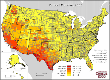
A directory of communities known for possessing a community or a large number of Mexican American
s. The majority (about 70 percent) live in five Western states (the Southwest US
) of California
, Texas
, Arizona
, Colorado
and New Mexico
. Mexican Americans are also found in all 50 states and has been increasing dramatically by Mexican immigration in the late 20th century, to states beyond the US-Mexico border region.
The largest communities by population are Los Angeles
, San Diego, San Francisco and San Jose, California
. But by percentage are Calexico
, Maywood
, Mecca
and Parlier
of California. There are Mexican American majority regions in Southern California
as well in southern Texas and southern Arizona.
More persons in northern New Mexico are Hispano
s; and Texas, some are Tejano
s than Mexican, as well Central America
n immigrant nationalities are fast outnumbering those of Mexican descent in many traditionally Chicano
or pre-1970s Mexican communities of (esp. southern) California and Phoenix, Arizona
, and Mexican immigration to some areas are variable in certain years to have lower percentages today than the last US census (2000).
or Spanish
than Mexican-American in Santa Fe
, where there is a cultural Mexican community nonetheless in the over 400 year old city and state capital.
, Cincinnati, Cleveland, Detroit, Minneapolis, New York City
, Newark
, Omaha
and Sioux City, Iowa
are notable; and so has Atlanta, Baltimore
, Boise, Idaho
, Charlotte, N.C., Helena, Montana
, Milwaukee, Pittsburgh, Providence, Rhode Island
and St. Louis. This is from a wave of Mexican immigration in the 1990s and 2000s.
Out of all these areas, Philadelphia has had the most impressive increase of Mexicans in the 1990s and 2000s. in 1990, only a couple thousands Mexicans called the Delaware Valley
home. As of 2010, between 50,000 and 80,000 Mexicans do the same (although many predict that the figures could be as high as 110,000). And the figures keep on rising.
(the Detroit metropolitan area); Chicagoland
; Northern Indiana
; Southern Wisconsin
; Detroit; Kansas City
; St. Louis
and Minneapolis-St. Paul have developed large Mexican (immigrant and American-born) populations. The states of Iowa
, Kansas
, Michigan
, Missouri
and Nebraska
attracted Mexican and Latino immigration in the late 20th century to work in meatpacking plants and agricultural harvests, now many of the states' counties and towns have high growth of Mexicans or Latinos.
Another destination was the Northeastern United States, in places such as the Monongahela Valley, Pennsylvania
; Mahoning Valley
, Ohio
; Hudson Valley
and Long Island
of New York
state; the Jersey Shore
region and Southern New Jersey
; New Haven, Connecticut
along with other Latin American nationalities; throughout Massachusetts
; Washington, D.C.
with Maryland
and Northern Virginia included; some parts of the states of Maine
, New Hampshire
, Rhode Island
and Delaware
; and the area's largest Mexican immigrant population is the Philadelphia metropolitan area.
Communities that consist mostly of recent-arrived immigrants from Mexico, are also present in other parts of the rural Southeastern United States
, in states such as Georgia
, Alabama
, Tennessee
, Louisiana
, Arkansas
and (part of the Southwest) Oklahoma
. A growing Mexican-American population is also present in urban areas such as Orlando, Florida
with the Central Florida
region included; the Lake Okeechobee
area of Florida
; the Atlanta
metropolitan area; the Memphis, Tennessee
area; Charlotte, North Carolina
-with a majority Hispanic enclave of Eastland, and Mexican immigration throughout the Piedmont
of North Carolina: i.e. Siler City, North Carolina
; New Orleans which increased after Hurricane Katrina
in Sep. 2005; the Hampton Roads
, Virginia
area; housing construction and remodeling brought large numbers of Mexicans into Oconee County, South Carolina; the Charleston, South Carolina
and Myrtle Beach, South Carolina
areas; and Ridgeland, South Carolina
.
Mexican American
Mexican Americans are Americans of Mexican descent. As of July 2009, Mexican Americans make up 10.3% of the United States' population with over 31,689,000 Americans listed as of Mexican ancestry. Mexican Americans comprise 66% of all Hispanics and Latinos in the United States...
s. The majority (about 70 percent) live in five Western states (the Southwest US
Southwestern United States
The Southwestern United States is a region defined in different ways by different sources. Broad definitions include nearly a quarter of the United States, including Arizona, California, Colorado, Nevada, New Mexico, Oklahoma, Texas and Utah...
) of California
California
California is a state located on the West Coast of the United States. It is by far the most populous U.S. state, and the third-largest by land area...
, Texas
Texas
Texas is the second largest U.S. state by both area and population, and the largest state by area in the contiguous United States.The name, based on the Caddo word "Tejas" meaning "friends" or "allies", was applied by the Spanish to the Caddo themselves and to the region of their settlement in...
, Arizona
Arizona
Arizona ; is a state located in the southwestern region of the United States. It is also part of the western United States and the mountain west. The capital and largest city is Phoenix...
, Colorado
Colorado
Colorado is a U.S. state that encompasses much of the Rocky Mountains as well as the northeastern portion of the Colorado Plateau and the western edge of the Great Plains...
and New Mexico
New Mexico
New Mexico is a state located in the southwest and western regions of the United States. New Mexico is also usually considered one of the Mountain States. With a population density of 16 per square mile, New Mexico is the sixth-most sparsely inhabited U.S...
. Mexican Americans are also found in all 50 states and has been increasing dramatically by Mexican immigration in the late 20th century, to states beyond the US-Mexico border region.
The largest communities by population are Los Angeles
Los Ángeles
Los Ángeles is the capital of the province of Biobío, in the commune of the same name, in Region VIII , in the center-south of Chile. It is located between the Laja and Biobío rivers. The population is 123,445 inhabitants...
, San Diego, San Francisco and San Jose, California
San Jose, California
San Jose is the third-largest city in California, the tenth-largest in the U.S., and the county seat of Santa Clara County which is located at the southern end of San Francisco Bay...
. But by percentage are Calexico
Calexico, California
Calexico is a city in Imperial County, California. The population was 38,572 at the 2010 census, up from 27,109 at the 2000 census. Calexico is about east of San Diego and west of Yuma, Arizona...
, Maywood
Maywood, California
Maywood is a small city in southeast Los Angeles County, California. At , Maywood is the third-smallest incorporated city in Los Angeles County....
, Mecca
Mecca, California
Mecca is a census-designated place in Riverside County, California, United States. The population was 8,577 at the 2010 census, up from 5,402 at the 2000 census....
and Parlier
Parlier, California
Parlier is a city in Fresno County, California, United States. As of the 2010 census, the city had a total population of 9,494, down from 11,145 at the 2000 census. The city has one of the state's highest percentage of Latinos, a large majority of them are seasonal migrant laborers who arrive and...
of California. There are Mexican American majority regions in Southern California
Southern California
Southern California is a megaregion, or megapolitan area, in the southern area of the U.S. state of California. Large urban areas include Greater Los Angeles and Greater San Diego. The urban area stretches along the coast from Ventura through the Southland and Inland Empire to San Diego...
as well in southern Texas and southern Arizona.
More persons in northern New Mexico are Hispano
Hispano
Hispano may relate to:* Hispano, , the Spanish word for the inhabitants of Pre-Roman and Roman Hispania , ....
s; and Texas, some are Tejano
Tejano
Tejano or Texano is a term used to identify a Texan of Mexican heritage.Historically, the Spanish term Tejano has been used to identify different groups of people...
s than Mexican, as well Central America
Central America
Central America is the central geographic region of the Americas. It is the southernmost, isthmian portion of the North American continent, which connects with South America on the southeast. When considered part of the unified continental model, it is considered a subcontinent...
n immigrant nationalities are fast outnumbering those of Mexican descent in many traditionally Chicano
Chicano
The terms "Chicano" and "Chicana" are used in reference to U.S. citizens of Mexican descent. However, those terms have a wide range of meanings in various parts of the world. The term began to be widely used during the Chicano Movement, mainly among Mexican Americans, especially in the movement's...
or pre-1970s Mexican communities of (esp. southern) California and Phoenix, Arizona
Phoenix, Arizona
Phoenix is the capital, and largest city, of the U.S. state of Arizona, as well as the sixth most populated city in the United States. Phoenix is home to 1,445,632 people according to the official 2010 U.S. Census Bureau data...
, and Mexican immigration to some areas are variable in certain years to have lower percentages today than the last US census (2000).
Arizona
- AvondaleAvondale, ArizonaAvondale is a city in Maricopa County, Arizona, USA, adjacent to Phoenix, Arizona. According to 2010 Census Bureau, the population of the city is 76,238.Avondale is the home of Phoenix International Raceway, an auto racing facility...
- BuckeyeBuckeye, ArizonaBuckeye is a town in Maricopa County, Arizona, United States and is the westernmost suburb in the Phoenix metropolitan area. The population of the town as of Census 2010 was 50,876, a 678% increase from the 2000 population of 6,537.-Geography:...
- Casa GrandeCasa Grande, ArizonaCasa Grande is a city in Pinal County, approximately halfway between Phoenix and Tucson in the U.S. state of Arizona. According to 2010 Census, the population of the city is 48,571...
- Cochise County, ArizonaCochise County, Arizona-2010:Whereas according to the 2010 U.S. Census Bureau:*78.5% White*4.2% Black*1.2% Native American*1.9% Asian*0.3% Native Hawaiian or Pacific Islander*4.0% Two or more races*9.6% Other races*32.4% Hispanic or Latino -2000:...
- DouglasDouglas, ArizonaDouglas is a city in Cochise County, Arizona, United States. Douglas has a border crossing with Mexico and a history of mining.The population was 14,312 at the 2000 census...
- El MirageEl Mirage, ArizonaEl Mirage is a city in Maricopa County, Arizona, United States. According to Census 2010, the population of the city is 31,767.-Geography:El Mirage is located at ....
- GoodyearGoodyear, ArizonaGoodyear is a city in Maricopa County, Arizona, United States. According to the 2010 census, the population of the city is 65,275...
- GuadalupeGuadalupe, ArizonaGuadalupe is a town in Maricopa County, Arizona, United States. According to 2006 Census Bureau estimates, the population of the town is 5,258. The town is nestled between Phoenix and Tempe. Since its founding, it has been known as a center of Yaqui culture and it is home to many religious festivals...
- MaranaMarana, ArizonaMarana is a town in Pima County, Arizona, located northwest of Tucson, with a small portion in Pinal County. According to the 2010 census, the population of the town is 34,961...
- MaricopaMaricopa, Arizona-Surrounding Municipalities:-Demographics:As of the census of 2010, there were 43,482 people, 14,359 households, and 11,110 families residing in the city. The population density was 1,356.8 people per square mile . There were 17,240 housing units at an average density of 540.4 per square mile...
- NogalesNogales, ArizonaNogales is a city in Santa Cruz County, Arizona, United States. The population was 21,017 at the 2010 census. According to 2005 Census Bureau estimates, the population of the city is 20,833. The city is the county seat of Santa Cruz County....
- Palo VerdePalo Verde, ArizonaPalo Verde is a small unincorporated community in Maricopa County, Arizona, United States. It is located about 40 miles west of Phoenix, and 6 miles southwest of downtown Buckeye....
- PhoenixPhoenix, ArizonaPhoenix is the capital, and largest city, of the U.S. state of Arizona, as well as the sixth most populated city in the United States. Phoenix is home to 1,445,632 people according to the official 2010 U.S. Census Bureau data...
- Pima County, ArizonaPima County, Arizona-2010:Whereas according to the 2010 U.S. Census Bureau:*74.3% White*3.5% Black*3.3% Native American*2.6% Asian*0.2% Native Hawaiian or Pacific Islander*3.7% Two or more races*12.4% Other races*34.6% Hispanic or Latino -2000:...
- Pinal County, ArizonaPinal County, Arizona-2010:Whereas according to the 2010 U.S. Census Bureau:*72.4% White*4.6% Black*5.6% Native American*1.7% Asian*0.4% Native Hawaiian or Pacific Islander*3.8% Two or more races*11.5% Other races*28.5% Hispanic or Latino -2000:...
- Santa Cruz County, ArizonaSanta Cruz County, Arizona-2010:Whereas according to the 2010 U.S. Census Bureau:*73.5% White*0.4% Black*0.7% Native American*0.5% Asian*0.0% Native Hawaiian or Pacific Islander*2.0% Two or more races*22.9% Other races*82.8% Hispanic or Latino -2000:...
- TollesonTolleson, ArizonaTolleson is a city in Maricopa County, Arizona, United States. According to 2006 Census Bureau estimates, the population of the city is 6,812.-Geography:Tolleson is located at ....
- TucsonTucson, ArizonaTucson is a city in and the county seat of Pima County, Arizona, United States. The city is located 118 miles southeast of Phoenix and 60 miles north of the U.S.-Mexico border. The 2010 United States Census puts the city's population at 520,116 with a metropolitan area population at 1,020,200...
- Verde Valley
- WickenburgWickenburg, ArizonaWickenburg is a town in Maricopa County, Arizona, United States. According to 2006 Census Bureau estimates, the population of the town is 6,423.-Geography:Wickenburg is located at ....
- YumaYuma, ArizonaYuma is a city in and the county seat of Yuma County, Arizona, United States. It is located in the southwestern corner of the state, and the population of the city was 77,515 at the 2000 census, with a 2008 Census Bureau estimated population of 90,041....
- Yuma County, ArizonaYuma County, Arizona-2010:Whereas according to the 2010 U.S. Census Bureau:*70.4% White*2.0% Black*1.6% Native American*1.2% Asian*0.2% Native Hawaiian or Pacific Islander*3.8% Two or more races*20.8% Other races*59.7% Hispanic or Latino -2000:...
Arkansas
- De QueenDe Queen, ArkansasDe Queen is a city and the county seat of Sevier County, Arkansas, United States. The population was 5,765 at the 2000 census.-Geography:De Queen is located at ....
- Fort SmithFort Smith, ArkansasFort Smith is the second-largest city in Arkansas and one of the two county seats of Sebastian County. With a population of 86,209 in 2010, it is the principal city of the Fort Smith, Arkansas-Oklahoma Metropolitan Statistical Area, a region of 298,592 residents which encompasses the Arkansas...
- Little RockLittle Rock, ArkansasLittle Rock is the capital and the largest city of the U.S. state of Arkansas. The Metropolitan Statistical Area had a population of 699,757 people in the 2010 census...
- RogersRogers, ArkansasRogers is a suburban city in Benton County, Arkansas, United States. As of the 2010 census, the city has a population of 55,964. The city is located in the Fayetteville-Springdale-Rogers Metropolitan Area, in the northwest corner of the state.-History:...
- SpringdaleSpringdale, ArkansasAs of the census of 2010, there were 69,797 people, 22,805 households, and 16,640 families residing in the city. The racial makeup of the city was 64.7% White, 0.82% Black or African American, 1.8% Native American, 1.4% Asian, 5.7% Pacific Islander, 22% from other races, and 2.9% from two or more...
- TexarkanaTexarkana, ArkansasAs of the census of 2000, there were 26,448 people, 10,384 households, and 7,040 families residing in the city. The population density was 830.5 people per square mile . There were 11,721 housing units at an average density of 368.1 per square mile...
- Van BurenVan Buren, ArkansasVan Buren is the second largest city in the Fort Smith, Arkansas-Oklahoma Metropolitan Statistical Area and the county seat of Crawford County, Arkansas, United States. The city is located directly northeast of Fort Smith at the Interstate 40 - Interstate 540 junction...
California
- Coachella ValleyCoachella ValleyCoachella Valley is a large valley landform in Southern California. The valley extends for approximately 45 miles in Riverside County southeast from the San Bernardino Mountains to the saltwater Salton Sea, the largest lake in California...
- Imperial ValleyImperial ValleyThe Imperial Valley is an agricultural area of Southern California's Imperial County. It is located in southeastern Southern California, centered around the city of El Centro. Locally, the terms "Imperial Valley" and "Imperial County" are used synonymously. The Valley is bordered between the...
- Lower Colorado River ValleyLower Colorado River ValleyThe Lower Colorado River Valley is the river region of the lower Colorado River of the southwestern United States in North America that rises in the Rocky Mountains and has its outlet at the Colorado River Delta in the northern Sea of Cortez in northwestern Mexico, between the states of Baja...
- Napa Valley
- Sonoma ValleySonoma ValleySonoma Valley is the birthplace of the California wine industry and often called The Valley of the Moon. Sonoma Valley is home to some of the earliest vineyards and wineries in the state, some of which survived the phylloxera epidemic of the 1870s and the impact of Prohibition...
- AnaheimAnaheim, CaliforniaAnaheim is a city in Orange County, California. As of the 2010 United States Census, the city population was about 365,463, making it the most populated city in Orange County, the 10th most-populated city in California, and ranked 54th in the United States...
- ArvinArvin, CaliforniaArvin is a city in Kern County, in the United States. Arvin is located southeast of Bakersfield, at an elevation of 449 feet . As of the 2010 census, the population was 19,304, up from 12,956 at the 2000 census....
- BakersfieldBakersfield, CaliforniaBakersfield is a city near the southern end of the San Joaquin Valley in Kern County, California. It is roughly equidistant between Fresno and Los Angeles, to the north and south respectively....
- Baldwin ParkBaldwin Park, CaliforniaBaldwin Park is a city located in the central San Gabriel Valley region of Los Angeles County, California, United States. As of the 2010 census, the population was 75,390, down from 75,837 at the 2000 census.- History :...
- BarstowBarstow, CaliforniaBarstow is a city in San Bernardino County, California, United States. The population was 22,639 at the 2010 census, up from 21,119 at the 2000 census. Barstow is located north of San Bernardino....
- BeaumontBeaumont, CaliforniaBeaumont is a city in Riverside County, California, United States in the Greater Los Angeles area.Now a growing, community planned city, the population was 36,877 at the 2010 census, and expected to be up to 125,000 projected by 2040, making Beaumont as California's next, newest fastest-growing...
- Bell GardensBell Gardens, CaliforniaBell Gardens is a city in Los Angeles County, California. The population was 42,072 at the 2010 census, down from 44,054 at the 2000 census.Bell Gardens is notable for being one of only five Los Angeles County cities to permit casino gambling...
- BrawleyBrawley, CaliforniaBrawley is a city in Imperial County, California, United States. Brawley is located north of El Centro. The population was 24,953 at the 2010 census, up from 22,052 at the 2000 census. The town has a significant cattle and feed industry, and hosts the annual Cattle Call Rodeo. Year-round...
- ChinoChino, CaliforniaChino is a city in San Bernardino County, California, United States. It is located in the western end of the Riverside-San Bernardino Area and it is easily accessible via the Chino Valley and Pomona freeways....
- CoachellaCoachella, CaliforniaCoachella is a city in Riverside County, California; it is the easternmost city in the region collectively known as the Coachella Valley...
- Colusa County, CaliforniaColusa County, CaliforniaColusa County is a county located in the Central Valley of the U.S. state of California, northwest of state capital Sacramento. As of the 2010 census, its population was 21,419. The county seat is Colusa.-History:...
- CoronaCorona, CaliforniaCorona is a city in Riverside County, California, United States. As of the 2010 census, the city had a population of 152,374, up from 124,966 at the 2000 census...
- Costa MesaCosta Mesa, CaliforniaCosta Mesa is a city in Orange County, California. The population was 109,960 at the 2010 census. Since its incorporation in 1953, the city has grown from a semi-rural farming community of 16,840 to a primarily suburban and "edge" city with an economy based on retail, commerce, and light...
- Culver CityCulver City, CaliforniaCulver City is a city in western Los Angeles County, California. As of the 2010 census, the city had a population of 38,883, up from 38,816 at the 2000 census. It is mostly surrounded by the city of Los Angeles, but also shares a border with unincorporated areas of Los Angeles County. Culver...
- Daly CityDaly City, CaliforniaDaly City is the largest city in San Mateo County, California, United States, with a 2010 population of 101,123. Located immediately south of San Francisco, it is named in honor of businessman and landowner John Daly.-History:...
- DavisDavis, CaliforniaDavis is a city in Yolo County, California, United States. It is part of the Sacramento–Arden-Arcade–Roseville Metropolitan Statistical Area...
- DelanoDelano, CaliforniaDelano's climate is characteristic of the San Joaquin Valley. The weather is hot and dry during the summer and cool and damp in winter. Frequent ground fog known regionally as "tule fog" can obscure vision. Record temperatures range between 115°F and 14°F...
- DowneyDowney, CaliforniaDowney is a city located in southeast Los Angeles County, California, United States, southeast of downtown Los Angeles. The city is best known as the birthplace of the Apollo space program, and is the city where folk singer Karen Carpenter lived and died...
- East Palo AltoEast Palo Alto, CaliforniaEast Palo Alto is a city in San Mateo County, California, United States.-Overview:As of the 2010 census, the population of East Palo Alto was 28,155. It is situated on the San Francisco Peninsula, roughly halfway between the cities of San Francisco and San Jose...
- El CentroEl Centro, CaliforniaEl Centro is a city in and county seat of Imperial County, the largest city in the Imperial Valley and the east anchor of the Southern California Border Region, and the core urban area and principal city of the El Centro metropolitan area which encompasses all of Imperial County. El Centro is also...
- El MonteEl Monte, CaliforniaEl Monte is a residential, industrial, and commercial city in Los Angeles County, California, United States. The city's slogan is "Welcome to Friendly El Monte," and historically is known as "The End of the Santa Fe Trail." As of the 2010 census, the city had a total population of 113,475,...
- EscondidoEscondido, CaliforniaEscondido is a city occupying a shallow valley ringed by rocky hills, just north of the city of San Diego, California. Founded in 1888, it is one of the oldest cities in San Diego County. The city had a population of 143,911 at the 2010 census. Its municipal government set itself an operating...
- FillmoreFillmore, CaliforniaFillmore is a city in Ventura County, California, United States. The population was 15,002 at the 2010 census, up from 13,643 at the 2000 census.- History :...
- FontanaFontana, CaliforniaFontana is a city of 196,069 residents in San Bernardino County, California. Founded in 1913, it remained essentially rural until World War II, when entrepreneur Henry J. Kaiser built a large steel mill in the area...
- FresnoFresno, CaliforniaFresno is a city in central California, United States, the county seat of Fresno County. As of the 2010 census, the city's population was 510,365, making it the fifth largest city in California, the largest inland city in California, and the 34th largest in the nation...
- Garden GroveGarden Grove, CaliforniaGarden Grove is a city located in northern Orange County, California. The population was 170,883 at the 2010 census. State Route 22, also known as the Garden Grove Freeway, passes through the city running east-west. The city is known outside the Southern California area for being the home of Robert H...
- Glenn County, CaliforniaGlenn County, CaliforniaGlenn County is in the California Central Valley. As of 2010, it had a population of 28,122. The county seat is the city of Willows.-History:Glenn County was formed in 1891 from parts of Colusa County. It was named for Dr. Hugh J...
- GonzalesGonzales, CaliforniaGonzales is a city in Monterey County, California, United States. Gonzales is located southeast of Salinas, at an elevation of 135 feet . The population was 8,187 at the 2010 census, up from 7,525 at the 2000 census. Gonzales is a member of the Association of Monterey Bay Area...
- GreenfieldGreenfield, CaliforniaGreenfield is a city in Monterey County, California, United States. Greenfield is located southeast of Salinas, at an elevation of 289 feet . The city was the fastest growing in the county during the 2000s, the population was 12,583 in 2000, increasing to 16,330 in the 2010 census. Its most...
- GuadalupeGuadalupe, CaliforniaGuadalupe is a small city located in Santa Barbara County, California. According to the U.S. Census of 2010, the city has a population of 7,080. It was incorporated as a city on May 19, 1946...
- HaywardHayward, CaliforniaHayward is a city located in the East Bay in Alameda County, California. With a population of 144,186, Hayward is the sixth largest city in the San Francisco Bay Area and the third largest in Alameda County. Hayward was ranked as the 37th most populous municipality in California. It is included in...
- HemetHemet, CaliforniaHemet is a city in the San Jacinto Valley in Riverside County, California, United States. It covers a total area of , about half of the valley, which it shares with the neighboring city of San Jacinto. The population was 78,657 at the 2010 census....
- HollisterHollister, CaliforniaHollister is a city in and the county seat of San Benito County, California, United States. The population was 34,928 at the 2010 census. Hollister is primarily an agricultural town.-History:...
- HornitosHornitos, CaliforniaHornitos is a census-designated place in Mariposa County, California. It is located on Burns Creek south of Coulterville, at an elevation of 843 feet . The population was 75 at the 2010 census....
in Mariposa County, CaliforniaMariposa County, CaliforniaMariposa County is a county in the U.S. state of California, located in the western foothills of the Sierra Nevada mountains. It lies north of Fresno, east of Merced, and southeast of Stockton. As of the 2010 census, the population was 18,251 up from 17,130 at the 2000 census... - HuronHuron, CaliforniaHuron is a small city in Fresno County, California, in the United States. As of the 2010 census, the population was 6,754, up from 6,306 at the 2000 census. During the harvest season, the population swells to over 15,000 people due to the influx of migrant farm workers. Huron is located ...
- IndioIndio, CaliforniaIndio is a city in Riverside County, California, United States, located in the Coachella Valley of Southern California's Colorado Desert region. It lies east of Palm Springs, east of Riverside, and east of Los Angeles. It is about north of Mexicali, Baja California on the U.S.-Mexican border...
- InglewoodInglewood, CaliforniaInglewood is a city in southwestern Los Angeles County, California, southwest of downtown Los Angeles. It was incorporated on February 14, 1908. Its population stood at 109,673 as of the 2010 Census...
- Kern County, CaliforniaKern County, CaliforniaSpreading across the southern end of the California Central Valley, Kern County is the fifth-largest county by population in California. Its economy is heavily linked to agriculture and to petroleum extraction, and there is a strong aviation and space presence. Politically, it has generally...
- Kings County, CaliforniaKings County, CaliforniaKings County is a county located in the Central Valley of the U.S. state of California. It is located in a rich agricultural region. Kings County is also home to NAS Lemoore, which is the U.S. Navy's newest and largest master jet air station. The county seat is Hanford...
- La PuenteLa Puente, CaliforniaLa Puente is a city in Los Angeles County, California, United States. The population was 39,816 at the 2010 census.* City flower: The Golden Hibiscus* City colors: Green and White.-History:...
- La QuintaLa Quinta, CaliforniaLa Quinta is a resort city in Riverside County, California, USA, specifically in the Coachella Valley between Indian Wells and Indio. The population was 37,467 at the 2010 census, up from 23,694 at the 2000 census. The Robb Report credits La Quinta as the nation's leading golf destination...
- LakewoodLakewood, CaliforniaLakewood is a city in Los Angeles County, California, United States. The population was 80,048 at the 2010 census. It is bordered by Long Beach on the west and south, Bellflower on the north, Cerritos on the northeast, Cypress on the east, and Hawaiian Gardens on the southeast. Major thoroughfares...
- LennoxLennox, CaliforniaLennox is a census-designated place in Los Angeles County, California, United States. The population was 22,753 at the 2010 census, down from 22,950 at the 2000 census.-Geography:...
- Long BeachLong Beach, CaliforniaLong Beach is a city situated in Los Angeles County in Southern California, on the Pacific coast of the United States. The city is the 36th-largest city in the nation and the seventh-largest in California. As of 2010, its population was 462,257...
- Los BanosLos Banos, CaliforniaLos Banos is a city in Merced County, California, near the junction of State Route 152 and Interstate 5. Los Banos is located southwest of Merced, at an elevation of 118 feet . The population was 35,972 at the 2010 census, up from 25,869 at the 2000 census...
- Los Angeles
- East L.A.East Los Angeles, CaliforniaEast Los Angeles is an unincorporated area and census-designated place in Los Angeles County, California, United States...
- South Los AngelesSouth Los AngelesSouth Los Angeles, often abbreviated as South L.A. and formerly South Central Los Angeles, is the official name for a large geographic and cultural portion lying to the southwest and southeast of downtown Los Angeles, California. The area was formerly called South Central, and is still widely known...
- Venice Beach - site of the Zoot Suit RiotsZoot Suit RiotsThe Zoot Suit Riots were a series of riots in 1943 during World War II that erupted in Los Angeles, California between white sailors and Marines stationed throughout thehi c mlc city and Latino youths, who were recognizable by the zoot suits they favored...
- East L.A.
- MaderaMadera, CaliforniaMadera is a city in and the county seat of Madera County, California, United States. It is a principal city of the Madera–Chowchilla Metropolitan Statistical Area, which encompasses all of Madera County, and Metropolitan Fresno. It is located in California's San Joaquin Valley. As of the 2010...
- Menlo ParkMenlo Park, CaliforniaMenlo Park, California is a city at the eastern edge of San Mateo County, in the San Francisco Bay Area of California, in the United States. It is bordered by San Francisco Bay on the north and east; East Palo Alto, Palo Alto, and Stanford to the south; Atherton, North Fair Oaks, and Redwood City...
- MercedMerced, CaliforniaMerced is a city in, and the county seat of, Merced County, California in the San Joaquin Valley of Northern California. As of the 2010 census, the city had a population of 78,958. Incorporated in 1889, Merced is a charter city that operates under a council-manager government...
- ModestoModesto, CaliforniaModesto is a city in, and is the county seat of, Stanislaus County, California. With a population of approximately 201,165 at the 2010 census, Modesto ranks as the 18th largest city in the state of California....
- Moreno ValleyMoreno Valley, CaliforniaMoreno Valley is a city located in Riverside County, California.A relatively young city, its rapid growth in the 1980s and the first decade of the 21st century made it second-largest city in Riverside County by population, and one of the Inland Empire's population centers. As of the 2010 census,...
- National CityNational City, CaliforniaNational City is a city in San Diego County, California. The population was 58,582 at the 2010 census, up from 54,260 at the 2000 census. National City is the second oldest city in San Diego County and has a historic past.-History:...
- NapaNapa, California-History:The name Napa was probably derived from the name given to a southern Nappan village whose people shared the area with elk, deer, grizzlies and cougars for many centuries, according to Napa historian Kami Santiago. At the time of the first recorded exploration into Napa Valley in 1823, the...
- NorwalkNorwalk, CaliforniaNorwalk is a suburban city in Los Angeles County, California, United States. The population was 105,549 at the 2010 census, up from 103,298 at the 2000 census, making it the 58th most populous city in California and the 255th nationally....
- OaklandOakland, CaliforniaOakland is a major West Coast port city on San Francisco Bay in the U.S. state of California. It is the eighth-largest city in the state with a 2010 population of 390,724...
- OceansideOceanside, California-2010:The 2010 United States Census reported that Oceanside had a population of 167,086. The population density was 3,961.8 people per square mile...
- OntarioOntario, CaliforniaOntario is a city located in San Bernardino County, California, United States, 35 miles east of downtown Los Angeles. Located in the western part of the Inland Empire region, it lies just east of the Los Angeles county line and is part of the Greater Los Angeles Area...
- OrangeOrange, CaliforniaSouthern California is well-known for year-round pleasant weather: - On average, the warmest month is August. - The highest recorded temperature was in 1985. - On average, the coolest month is December. - The lowest recorded temperature was in 1950...
- OrovilleOroville, CaliforniaOroville is the county seat of Butte County, California. The population was 15,506 at the 2010 census, up from 13,004 at the 2000 census...
- OxnardOxnard, CaliforniaOxnard is the 113th largest city in the United States, 19th largest city in California and largest city in Ventura County, California, by way of population. It is located at the western edge of the fertile Oxnard Plain, and is an important agricultural center, with its distinction as the...
- Palm SpringsPalm Springs, CaliforniaPalm Springs is a desert city in Riverside County, California, within the Coachella Valley. It is located approximately 37 miles east of San Bernardino, 111 miles east of Los Angeles and 136 miles northeast of San Diego...
- PerrisPerris, CaliforniaPerris is a city in Riverside County, California, USA. At the 2010 census, the city population was 68,386, up from 36,189 at the 2000 census. The city is named in honor of Fred T. Perris, chief engineer of the California Southern Railroad...
- Pico RiveraPico Rivera, CaliforniaPico Rivera is a city located in southeastern Los Angeles County, California, United States. The city is situated approximately 11 miles southeast of downtown Los Angeles, on the eastern edge of the Los Angeles basin, and on the southern edge of the area known as the San Gabriel Valley...
- PomonaPomona, California-2010:The 2010 United States Census reported that Pomona had a population of 149,058, a slight decline from the 2000 census population. The population density was 6,491.2 people per square mile...
- Rancho CucamongaRancho Cucamonga, CaliforniaRancho Cucamonga is a suburban city in San Bernardino County, California. As of the 2010 census, the city had a population of 165,269, up from 127,743 at the 2000 census. L. Dennis Michael was elected as Mayor on November 2, 2010. Jack Lam is the City Manager...
- Redwood CityRedwood City, CaliforniaRedwood City is a California charter city located on the San Francisco Peninsula in Northern California, approximately 27 miles south of San Francisco, and 24 miles north of San Jose. Redwood City's history spans from its earliest inhabitation by the Ohlone people, to its tradition as a port for...
- Little Mexico - ReedleyReedley, CaliforniaReedley is a city in Fresno County, California, United States. Reedley is located east-southeast of Fresno, at an elevation of 348 feet . The population at the 2010 census was 24,194. Its chief economic source is agriculture, particularly fruit and vegetable cultivation. The city is dubbed as...
- RialtoRialto, California-2010:The 2010 United States Census reported that Rialto had a population of 99,171. The population density was 4,434.1 people per square mile . The racial makeup of Rialto was 43,592 White, 16,236 African American, 1,062 Native American, 2,258 Asian, 361 Pacific Islander, 30,993 from other...
- RichmondRichmond, CaliforniaRichmond is a city in western Contra Costa County, California, United States. The city was incorporated on August 7, 1905. It is located in the East Bay, part of the San Francisco Bay Area. It is a residential inner suburb of San Francisco, as well as the site of heavy industry, which has been...
- Rio LindaRio Linda, CaliforniaRio Linda is a census-designated place in Sacramento County, California, United States. It is part of the Sacramento–Arden-Arcade–Roseville Metropolitan Statistical Area. As of the 2010 census, the CDP population was 15,106, up from 10,466 at the 2000 census...
- RiversideRiverside, CaliforniaRiverside is a city in Riverside County, California, United States, and the county seat of the eponymous county. Named for its location beside the Santa Ana River, it is the largest city in the Riverside-San Bernardino-Ontario metropolitan area of Southern California, 4th largest inland California...
- RomolandRomoland, CaliforniaRomoland is a census-designated place in Riverside County, California, United States. The population was 1,684 at the 2010 census, down from 2,764 at the 2000 census....
- SacramentoSacramento, CaliforniaSacramento is the capital city of the U.S. state of California and the county seat of Sacramento County. It is located at the confluence of the Sacramento River and the American River in the northern portion of California's expansive Central Valley. With a population of 466,488 at the 2010 census,...
- SalinasSalinas, CaliforniaSalinas is the county seat and the largest municipality of Monterey County, California. Salinas is located east-southeast of the mouth of the Salinas River, at an elevation of about 52 feet above sea level. The population was 150,441 at the 2010 census...
- San Benito County, CaliforniaSan Benito County, CaliforniaSan Benito County is a county located in the Coast Range Mountains of the U.S. state of California, south of San Jose. As of 2010 the population was 55,269. The county seat is Hollister, which includes nearly two-thirds of the county's population. El Camino Real passes through the county and...
- San BernardinoSan Bernardino, CaliforniaSan Bernardino is a city located in the Riverside-San Bernardino metropolitan area , and serves as the county seat of San Bernardino County, California, United States...
- San BrunoSan Bruno, CaliforniaSan Bruno is a city in San Mateo County, California, United States. The population was 41,114 at the 2010 census.The city is adjacent to San Francisco International Airport and Golden Gate National Cemetery.-Geography:San Bruno is located at...
- San DiegoSan Diego, CaliforniaSan Diego is the eighth-largest city in the United States and second-largest city in California. The city is located on the coast of the Pacific Ocean in Southern California, immediately adjacent to the Mexican border. The birthplace of California, San Diego is known for its mild year-round...
- San FernandoSan Fernando, CaliforniaSan Fernando is a city located in the San Fernando Valley, in northwestern region of Los Angeles, California, United States. The population was 23,645 at the 2010 census, up from 23,564 at the 2000 census.-History:...
- San FranciscoSan Francisco, CaliforniaSan Francisco , officially the City and County of San Francisco, is the financial, cultural, and transportation center of the San Francisco Bay Area, a region of 7.15 million people which includes San Jose and Oakland...
- Mission District - San GabrielSan Gabriel, CaliforniaSan Gabriel is a city in Los Angeles County, California, United States. It is named after the Mission San Gabriel Arcángel, founded by Junipero Serra. The city grew outward from the mission and in 1852 became the original township of Los Angeles County. San Gabriel was incorporated in 1913...
- San JacintoSan Jacinto, CaliforniaSan Jacinto is a city in Riverside County, California, U.S.A. It was named after Saint Hyacinth and is located at the north end of the San Jacinto Valley, with Hemet to its south. The mountains associated with the valley are the San Jacinto Mountains. The population was 44,199 at the 2010...
- San JoseSan Jose, CaliforniaSan Jose is the third-largest city in California, the tenth-largest in the U.S., and the county seat of Santa Clara County which is located at the southern end of San Francisco Bay...
- East Side - San Joaquin ValleySan Joaquin ValleyThe San Joaquin Valley is the area of the Central Valley of California that lies south of the Sacramento – San Joaquin River Delta in Stockton...
- San Luis ObispoSan Luis Obispo, CaliforniaSan Luis Obispo is a city in California, located roughly midway between San Francisco and Los Angeles on the Central Coast. Founded in 1772 by Spanish Fr. Junipero Serra, San Luis Obispo is one of California’s oldest communities...
- San MateoSan Mateo, CaliforniaSan Mateo is a city in San Mateo County, California, United States, in the San Francisco Bay Area. With a population of approximately 100,000 , it is one of the larger suburbs on the San Francisco Peninsula, located between Burlingame to the north, Foster City to the east, Belmont to the south,...
- San MarcosSan Marcos, CaliforniaSan Marcos is a suburb of San Diego in the North County section of San Diego County, California. As of the 2010 census, the city had a total population of 83,781. Outside the San Diego region, it is best known as the home of California State University, San Marcos...
- San PabloSan Pablo, CaliforniaSan Pablo is a city in Contra Costa County, California, United States. The city of Richmond surrounds nearly the whole city. The population was 29,139 at the 2010 census. The current Mayor is Paul V. Morris, and the current Vice Mayor is Cecilia Valdez. Current Councilmembers include Arturo M....
- San RafaelSan Rafael, CaliforniaSan Rafael is a city and the county seat of Marin County, California, United States. The city is located in the North Bay region of the San Francisco Bay Area...
- Santa AnaSanta Ana, CaliforniaSanta Ana is the county seat and second most populous city in Orange County, California, and with a population of 324,528 at the 2010 census, Santa Ana is the 57th-most populous city in the United States....
- Santa BarbaraSanta Barbara, CaliforniaSanta Barbara is the county seat of Santa Barbara County, California, United States. Situated on an east-west trending section of coastline, the longest such section on the West Coast of the United States, the city lies between the steeply-rising Santa Ynez Mountains and the Pacific Ocean...
- Santa ClaraSanta Clara, CaliforniaSanta Clara , founded in 1777 and incorporated in 1852, is a city in Santa Clara County, in the U.S. state of California. The city is the site of the eighth of 21 California missions, Mission Santa Clara de Asís, and was named after the mission. The Mission and Mission Gardens are located on the...
- Santa Cruz County, CaliforniaSanta Cruz County, CaliforniaSanta Cruz County is a county located on the Pacific coast of the U.S. state of California, on the California Central Coast. The county forms the northern coast of the Monterey Bay. . As of the 2010 U.S. Census, its population was 262,382. The county seat is Santa Cruz...
- Santa MariaSanta Maria, CaliforniaSanta Maria is a city in Santa Barbara County, on the Central Coast of California. The 2010 census population was 100,062, putting it ahead of Santa Barbara for the first time and making it the largest city in the county...
- Santa PaulaSanta Paula, CaliforniaSanta Paula is a city within Ventura County, California, United States. The population was 29,321 at the 2010 census, up from 28,598 at the 2000 census...
- Santa RosaSanta Rosa, CaliforniaSanta Rosa is the county seat of Sonoma County, California, United States. The 2010 census reported a population of 167,815. Santa Rosa is the largest city in California's Wine Country and fifth largest city in the San Francisco Bay Area, after San Jose, San Francisco, Oakland, and Fremont and 26th...
- SangerSanger, CaliforniaSanger is a city in Fresno County, California, United States. The population was 24,270 at the 2010 census, up from 18,731 at the 2000 census. Sanger is located east-southeast of Fresno, at an elevation of 371 feet .- Geography :...
- SeasideSeaside, CaliforniaSeaside is a city in Monterey County, California, United States, with a population of 33,025 as of the 2010 census. Seaside is located east-northeast of Monterey, at an elevation of 33 feet...
- Solano County, CaliforniaSolano County, CaliforniaSolano County is a county located in Bay-Delta region of the U.S. state of California, about halfway between San Francisco and Sacramento and is one of the nine San Francisco Bay Area counties. The county's population was reported by the U.S. Census to be 413,344 in 2010...
- SoledadSoledad, CaliforniaSoledad, meaning "solitude" and "loneliness" in Spanish, is a city in Monterey County, California, United States. Soledad is located southeast of Salinas, at an elevation of 190 feet...
- Sonoma County, CaliforniaSonoma County, CaliforniaSonoma County, located on the northern coast of the U.S. state of California, is the largest and northernmost of the nine San Francisco Bay Area counties. Its population at the 2010 census was 483,878. Its largest city and county seat is Santa Rosa....
- South GateSouth Gate, CaliforniaSouth Gate is a city in Los Angeles County, California, United States. The sixteenth largest city in Los Angeles County, it encompasses . South Gate is located just southeast of downtown Los Angeles It is part of the Gateway Cities region of southeastern Los Angeles County...
- South San FranciscoSouth San Francisco, CaliforniaSouth San Francisco is a city in San Mateo County, California, United States, located on the San Francisco Peninsula in the San Francisco Bay Area...
- StocktonStockton, CaliforniaStockton, California, the seat of San Joaquin County, is the fourth-largest city in the Central Valley of the U.S. state of California. With a population of 291,707 at the 2010 census, Stockton ranks as this state's 13th largest city...
- Sutter County, CaliforniaSutter County, CaliforniaSutter County is a county located along the Sacramento River in the Central Valley of the U.S. state of California, north of state capital Sacramento. Sutter County is part of the Greater Sacramento CSA....
- TehachapiTehachapi, CaliforniaTehachapi is a city incorporated in 1909 located in the Tehachapi Mountains between Bakersfield and Mojave in Kern County, California. Tehachapi is located east-southeast of Bakersfield, at an elevation of...
- ThermalThermal, CaliforniaThermal is a census-designated place located approximately 25 miles southeast of Palm Springs and about 9.5 miles north of the Salton Sea. Although one can find sunny skies most days, residents occasionally endure strong winds and sizzling summer temperatures well above 100 degrees Fahrenheit. The...
- TorranceTorrance, CaliforniaTorrance is a city incorporated in 1921 and located in the South Bay region of Los Angeles County, California, United States. Torrance has of shore-front beaches on the Pacific Ocean, quieter and less well-known by tourists than others on the Santa Monica Bay, such as those of neighboring...
- Tulare County, CaliforniaTulare County, CaliforniaTulare County is a county located in the Central Valley of the U.S. state of California, south of Fresno. Sequoia National Park is located in the county, as are part of Kings Canyon National Park, in its northeast corner , and part of Mount Whitney, on its eastern border...
- TustinTustin, California-Top employers:According to the City's 2010 Comprehensive Annual Financial Report, the top employers in the city are:-2010:The 2010 United States Census reported that Tustin had a population of 75,540. The population density was 6,816.7 people per square mile...
- UplandUpland, CaliforniaUpland is a city in San Bernardino County, California, located at an elevation of 1,242 feet . As of the 2010 census, the city had a population of 73,732, up from 68,393 at the 2000 census. It was incorporated on May 15, 1906, after previously being named North Ontario.-History and culture:Upland...
- VallejoVallejo, CaliforniaVallejo is the largest city in Solano County, California, United States. The population was 115,942 at the 2010 census. It is located in the San Francisco Bay Area on the northeastern shore of San Pablo Bay...
- VenturaVentura, CaliforniaVentura is the county seat of Ventura County, California, United States, incorporated in 1866. The population was 106,433 at the 2010 census, up from 100,916 at the 2000 census. Ventura is accessible via U.S...
- VictorvilleVictorville, CaliforniaVictorville is a city located in the Victor Valley of southwestern San Bernardino County, California. According to the U.S. Census Bureau's 2010 census, the city had a population of 115,903, up from 64,030 at the 2000 census.-Geography and climate:...
- WatsonvilleWatsonville, CaliforniaWatsonville is a city in Santa Cruz County, California, United States. The population was 51,199 according to the 2010 census.Located on the central coast of California, the economy centers predominantly around the farming industry. It is known for growing strawberries, apples, lettuce and a host...
- West CovinaWest Covina, CaliforniaWest Covina is a city located in Los Angeles County, California. Located some east of Downtown Los Angeles in the eastern San Gabriel Valley, it is a mostly middle class suburb of Los Angeles...
- WilliamsWilliams, CaliforniaWilliams is a city in Colusa County, California, United States. The population was 5,123 at the 2010 census, up from 3,670 at the 2000 census. It is a traveler's city with many fast food restaurants, motels, and gas stations...
- Yolo County, CaliforniaYolo County, CaliforniaYolo County is a county located in the northern part of the U.S. state of California, bordered by the other counties of Sacramento, Solano, Napa, Lake, Colusa, and Sutter. The city of Woodland is its county seat, though Davis is its largest city....
- Yuba CityYuba City, CaliforniaYuba City is a Northern California city, founded in 1849. It is the county seat of Sutter County, California, United States. The population was 64,925 at the 2010 census....
Colorado
- AlamosaAlamosa, ColoradoThe city of Alamosa is a Home Rule Municipality that is the county seat and the most populous city of Alamosa County, Colorado, United States. The United States Census Bureau estimates that the city population was 8,682 in 2005...
- AspenAspen, ColoradoThe City of Aspen is a Home Rule Municipality that is the county seat and the most populous city of Pitkin County, Colorado, United States. The United States Census Bureau estimates that the city population was 5,804 in 2005...
- BurlingtonBurlington, ColoradoBurlington is a Home Rule Municipality, county seat, most populous place and only city in Kit Carson County, Colorado, United States. Its population was 4191 at the U.S. Census 2010...
- Colorado SpringsColorado Springs, ColoradoColorado Springs is a Home Rule Municipality that is the county seat and most populous city of El Paso County, Colorado, United States. Colorado Springs is located in South-Central Colorado, in the southern portion of the state. It is situated on Fountain Creek and is located south of the Colorado...
- CortezCortez, ColoradoThe city of Cortez is a Home Rule Municipality that is the county seat and the most populous city of Montezuma County, Colorado, United States. The city population was 8,482 at the 2010 census...
- DenverDenver, ColoradoThe City and County of Denver is the capital and the most populous city of the U.S. state of Colorado. Denver is a consolidated city-county, located in the South Platte River Valley on the western edge of the High Plains just east of the Front Range of the Rocky Mountains...
- DurangoDurango, ColoradoThe City of Durango is a Home Rule Municipality that is the county seat and the most populous city of La Plata County, Colorado, United States. The United States Census Bureau said that the city population was 16,887 in 2010 census.-History:...
- Eagle CountyEagle County, ColoradoEagle County is the thirteenth most populous of the 64 counties of the State of Colorado in the United States. The county is named for the Eagle River. The county population was 41,659 at U.S. Census 2000. The county seat is the Town of Eagle...
- GreeleyGreeley, ColoradoThe City of Greeley is a Home Rule Municipality that is the county seat and the most populous city of Weld County, Colorado, United States. Greeley is located in the region known as Northern Colorado. Greeley is situated north-northeast of the Colorado State Capitol in Denver. According to the...
- Las AnimasLas Animas, Colorado200px|right|thumb|St. Mary's [[Catholic]] Church in Las AnimasThe city of Las Animas is a Statutory City that is the county seat of, and the only incorporated municipality in, Bent County, Colorado, United States. The population was 2,410 at the 2010 census. Las Animas, located in southeast...
- La JuntaLa Junta, ColoradoThe City of La Junta is a Home Rule Municipality that is the county seat and the most populous city of Otero County, Colorado, United States. The city population was 7,568 at the U.S. Census 2000. La Junta is located on the Arkansas River in southeastern Colorado east of Pueblo.-History:During...
- Monte VistaMonte Vista, ColoradoThe City of Monte Vista is a Home Rule Municipality that is the most populous city in Rio Grande County, Colorado, United States. The population was 4,529 at the 2000 census.-Geography:...
- Pagosa SpringsPagosa Springs, ColoradoPagosa Springs is a Home Rule Municipality that is the county seat of, and the only incorporated municipality in, Archuleta County, Colorado, United States. The population was 1,591 at the 2000 census...
- PuebloPueblo, ColoradoPueblo is a Home Rule Municipality that is the county seat and the most populous city of Pueblo County, Colorado, United States. The population was 106,595 in 2010 census, making it the 246th most populous city in the United States....
- RicoRico, ColoradoRico is a Home Rule Municipality in Dolores County, Colorado, United States. The population was 205 at the 2000 census.-Geography:Rico is located at ....
- San Luis ValleySan Luis ValleyThe San Luis Valley is an extensive alpine valley in the U.S. states of Colorado and New Mexico covering approximately and sitting at an average elevation of above sea level. The valley sits atop the Rio Grande Rift and is drained to the south by the Rio Grande River, which rises in the San Juan...
- Steamboat SpringsSteamboat Springs, ColoradoThe city of Steamboat Springs is a Home Rule Municipality that is the county seat and the most populous city of Routt County, Colorado, United States. The city is also known as "Steamboat," "The Boat," or "Ski Town USA". As of the 2010 census, the city population was 12,088.The city is an...
- SterlingSterling, ColoradoThe City of Sterling is a Home Rule Municipality that is the county seat and the most populous city of Logan County, Colorado, United States. The city population was 14,777 at the 2010 census.-Geography:Sterling is located at...
- TellurideTelluride, ColoradoThe town of Telluride is the county seat and most populous town of San Miguel County in the southwestern portion of the U.S. state of Colorado. The town is a former silver mining camp on the San Miguel River in the western San Juan Mountains...
- TrinidadTrinidad, ColoradoThe historic City of Trinidad is a Home Rule Municipality that is the county seat and the most populous city of Las Animas County, Colorado, United States...
- VailVail, ColoradoThe Town of Vail is a Home Rule Municipality in Eagle County, Colorado, United States. The population of the town was 4,589 in 2005. The town was established and built as the base village to Vail Ski Resort, with which it was originally conceived...
- WalsenburgWalsenburg, ColoradoThe City of Walsenburg or Los Leones is a Statutory City that is the county seat and the most populous city of Huerfano County, Colorado, United States...
New Mexico
There are more Hispanics self-identify themselves as HispanoHispano
Hispano may relate to:* Hispano, , the Spanish word for the inhabitants of Pre-Roman and Roman Hispania , ....
or Spanish
Spanish American
A Spanish American is a citizen or resident of the United States whose ancestors originate from the southwestern European nation of Spain. Spanish Americans are the earliest European American group, with a continuous presence since 1565.-Immigration waves:...
than Mexican-American in Santa Fe
Santa Fe, New Mexico
Santa Fe is the capital of the U.S. state of New Mexico. It is the fourth-largest city in the state and is the seat of . Santa Fe had a population of 67,947 in the 2010 census...
, where there is a cultural Mexican community nonetheless in the over 400 year old city and state capital.
- AlbuquerqueAlbuquerque, New MexicoAlbuquerque is the largest city in the state of New Mexico, United States. It is the county seat of Bernalillo County and is situated in the central part of the state, straddling the Rio Grande. The city population was 545,852 as of the 2010 Census and ranks as the 32nd-largest city in the U.S. As...
- AztecAztec, New MexicoAztec is a city in San Juan County, New Mexico, United States. It is part of the Farmington, New Mexico Metropolitan Statistical Area. The population was 6,378 at the 2000 census. It is the county seat of San Juan County...
- BelenBelen, New MexicoBelen is a city in Valencia County, New Mexico, United States. Belen is Spanish for Bethlehem, and over time has gained the nickname "Hub City" because of the Belen Cutoff of the Atchison, Topeka and Santa Fe Railway. The Cutoff made it possible for many more trains to travel east and west across...
- ColumbusColumbus, New MexicoColumbus is a village in Luna County, New Mexico, United States. The population was 1,765 at the 2000 census. The town is named after 15th century explorer Christopher Columbus.-History:...
- DemingDeming, New MexicoDeming is a city in Luna County, New Mexico, United States, located 60 miles west of Las Cruces. The population was 14,116 at the 2000 census. Deming is the county seat and principal town of Luna County.-History:...
- GallupGallup, New Mexico- Demographics :As of the census of 2000, there were 20,209 people, 6,810 households, and 4,869 families residing in the city. The population density was 1,513.7 people per square mile...
- Las CrucesLas Cruces, New MexicoLas Cruces, also known as "The City of the Crosses", is the county seat of Doña Ana County, New Mexico, United States. The population was 97,618 in 2010 according to the 2010 Census, making it the second largest city in the state....
- Los LunasLos Lunas, New Mexico-2010:Whereas according to the 2010 U.S. Census Bureau:*72.1% White*2.0% Black*2.5% Native American*0.8% Asian*0.1% Native Hawaiian or Pacific Islander*4.2% Two or more races*18.3% Other races*57.9% Hispanic or Latino -2000:...
- RoswellRoswell, New MexicoRoswell is a city in and the county seat of Chaves County in the southeastern quarter of the state of New Mexico, United States. The population was 48,366 at the 2010 census. It is a center for irrigation farming, dairying, ranching, manufacturing, distribution, and petroleum production. It is also...
- Silver CitySilver City, New MexicoSilver City is a town in Grant County, New Mexico, in the United States. As of the 2000 census, the town population was 10,545. It is the county seat of Grant County. The city is the home of Western New Mexico University.-History:...
- SocorroSocorro, New MexicoSocorro is a city in Socorro County in the U.S. state of New Mexico. It stands in the Rio Grande Valley at an elevation of . The population was 9,051 at the 2010 census...
- Sunland ParkSunland Park, New MexicoSunland Park is a city in Doña Ana County, New Mexico, United States. The population was 14,106 at the 2010 census. Though it lies directly across from El Paso, Texas, being in Doña Ana County makes it instead a part of the Las Cruces Metropolitan Statistical Area, some 30 miles to the north.The...
Oregon
- AshlandAshland, OregonAshland is a city in Jackson County, Oregon, United States, near Interstate 5 and the California border, and located in the south end of the Rogue Valley. It was named after Ashland County, Ohio, point of origin of Abel Helman and other founders, and secondarily for Ashland, Kentucky, where other...
- BendBend, OregonBend is a city in and the county seat of Deschutes County, Oregon, United States, and the principal city of the Bend, Oregon Metropolitan Statistical Area. Bend is Central Oregon's largest city, and, despite its modest size, is the de facto metropolis of the region, owing to the low population...
- CorvallisCorvallis, OregonCorvallis is a city located in central western Oregon, United States. It is the county seat of Benton County and the principal city of the Corvallis, Oregon Metropolitan Statistical Area, which encompasses all of Benton County. As of the 2010 United States Census, the population was 54,462....
- Grants Pass, OregonGrants Pass, Oregon-Rogue River:The Rogue River runs through Grants Pass.-Demographics:As of the census of 2000, there were 23,003 people, 9,376 households, and 5,925 families residing in the city. The population density was . There were 9,885 housing units at an average density of 1,303.3 per square mile . By 2008,...
- Klamath Falls, OregonKlamath Falls, OregonKlamath Falls is a city in Klamath County, Oregon, United States. Originally called Linkville when George Nurse founded the town in 1867, after the Link River on whose falls this city sat, although no falls currently exist; the name was changed to Klamath Falls in 1892...
- La GrandeLa Grande, Oregon-Demographics:As of the census of 2000, there were 12,327 people, 5,124 households, and 2,982 families residing in the city. The population density was 2,833.5 people per square mile . There were 5,483 housing units at an average density of 1,260.3 per square mile...
- MadrasMadras, OregonMadras is a city in Jefferson County, Oregon, United States. Originally called The Basin after the circular valley the city is located in, it is unclear as to whether Madras was named in 1903 for the cotton fabric called "Madras" that originated in the Madras area in India, or from the city of...
- MedfordMedford, OregonMedford is a city in Jackson County, Oregon, United States. As of the 2010 US Census, the city had a total population of 74,907 and a metropolitan area population of 207,010, making the Medford MSA the 4th largest metro area in Oregon...
- NyssaNyssa, OregonNyssa is a city in Malheur County, Oregon, United States. The population was 3,163 at the 2000 census. The city is located along the Snake River on the Idaho border, in the region of far eastern Oregon known as the "Treasure Valley"...
/Nyassa, Idaho - OntarioOntario, OregonOntario is the largest city in Malheur County, Oregon, United States. It lies along the Snake River at the Idaho border. The population was 10,985 at the 2000 census, with an estimated population of 11,245 in 2006...
- PendletonPendleton, OregonPendleton is a city in Umatilla County, Oregon, United States. Pendleton was named in 1868 by the county commissioners for George H. Pendleton, Democratic candidate for Vice-President in the 1864 presidential campaign. The population was 16,612 at the 2010 census...
- PortlandPortland, OregonPortland is a city located in the Pacific Northwest, near the confluence of the Willamette and Columbia rivers in the U.S. state of Oregon. As of the 2010 Census, it had a population of 583,776, making it the 29th most populous city in the United States...
- RoseburgRoseburg, OregonRoseburg is a city in the U.S. state of Oregon. It is the county seat of Douglas County. The population was 21,181 at the 2010 census.-History:...
- SalemSalem, OregonSalem is the capital of the U.S. state of Oregon, and the county seat of Marion County. It is located in the center of the Willamette Valley alongside the Willamette River, which runs north through the city. The river forms the boundary between Marion and Polk counties, and the city neighborhood...
- TalentTalent, OregonTalent is a city in Jackson County, Oregon, United States. The population was 5,589 at the 2000 census and 6,680 as of July 1, 2009.-Geography:According to the United States Census Bureau, the city has a total area of , all of it land....
- Tule Lake, OR/CA
- Willamette ValleyWillamette ValleyThe Willamette Valley is the most populated region in the state of Oregon of the United States. Located in the state's northwest, the region is surrounded by tall mountain ranges to the east, west and south and the valley's floor is broad, flat and fertile because of Ice Age conditions...
, OregonOregonOregon is a state in the Pacific Northwest region of the United States. It is located on the Pacific coast, with Washington to the north, California to the south, Nevada on the southeast and Idaho to the east. The Columbia and Snake rivers delineate much of Oregon's northern and eastern... - WoodburnWoodburn, OregonWoodburn is a city in Marion County, Oregon, United States. Incorporated in 1889, the community had been platted in 1871 after the arrival of the railroad. The city is located in the northern end of the Willamette Valley along Interstate 5 between Portland and Salem...
Texas
- Rio Grande Valley, TexasRio Grande ValleyThe Rio Grande Valley or the Lower Rio Grande Valley, informally called The Valley, is an area located in the southernmost tip of South Texas...
- South TexasSouth TexasSouth Texas is a region of the U.S. state of Texas that lies roughly south of and including San Antonio. The southern and western boundary is the Rio Grande River, and to the east it is the Gulf of Mexico. The population of this region is about 3.7 million. The southern portion of this region is...
- West TexasWest TexasWest Texas is a vernacular term applied to a region in the southwestern quadrant of the United States that primarily encompasses the arid and semi-arid lands in the western portion of the state of Texas....
- AliceAlice, TexasAt the 2000 census, there were 19,010 people, 6,400 households and 4,915 families residing in the city. The population density was 1,597.4 per square mile . There were 6,998 housing units at an average density of 588.0 per square mile...
- AustinAustin, TexasAustin is the capital city of the U.S. state of :Texas and the seat of Travis County. Located in Central Texas on the eastern edge of the American Southwest, it is the fourth-largest city in Texas and the 14th most populous city in the United States. It was the third-fastest-growing large city in...
- BeaumontBeaumont, TexasBeaumont is a city in and county seat of Jefferson County, Texas, United States, within the Beaumont–Port Arthur Metropolitan Statistical Area. The city's population was 118,296 at the 2010 census. With Port Arthur and Orange, it forms the Golden Triangle, a major industrial area on the...
- CotullaCotulla, TexasCotulla is a city in and the county seat of La Salle County, Texas, United States. The population was 3,614 at the 2000 census.-History:In 1868, Polish immigrant Joseph Cotulla arrived in La Salle County and eventually established a large ranching operation...
- Corpus ChristiCorpus Christi, TexasCorpus Christi is a coastal city in the South Texas region of the U.S. state of Texas. The county seat of Nueces County, it also extends into Aransas, Kleberg, and San Patricio counties. The MSA population in 2008 was 416,376. The population was 305,215 at the 2010 census making it the...
- Crystal CityCrystal City, TexasCrystal City is a city in and the county seat of Zavala County, Texas, United States. The population was 7,190 at the 2000 census. The mascot of Crystal City High School is the Javelina....
- DallasDallas, TexasDallas is the third-largest city in Texas and the ninth-largest in the United States. The Dallas-Fort Worth Metroplex is the largest metropolitan area in the South and fourth-largest metropolitan area in the United States...
- Del RioDel Rio, TexasDel Rio is a border city in and the county seat of Val Verde County, Texas, United States.. Del Rio is connected with Ciudad Acuña via the Lake Amistad Dam International Crossing and Del Río-Ciudad Acuña International Bridge...
- Eagle PassEagle Pass, TexasEagle Pass is a city in and the county seat of Maverick County The population was 27,183 as of the 2010 census.Eagle Pass borders the city of Piedras Negras, Coahuila, Mexico, which is to the southwest and across the Rio Grande. The Eagle Pass-Piedras Negras Metropolitan Area is one of six...
- El PasoEl Paso, TexasEl Paso, is a city in and the county seat of El Paso County, Texas, United States, and lies in far West Texas. In the 2010 census, the city had a population of 649,121. It is the sixth largest city in Texas and the 19th largest city in the United States...
- FabensFabens, TexasFabens is a census-designated place in El Paso County, Texas, United States. The population was 8,043 at the 2000 census. It is part of the El Paso Metropolitan Statistical Area...
and the nearby town of Guadalupe.
- Fort WorthFort Worth, TexasFort Worth is the 16th-largest city in the United States of America and the fifth-largest city in the state of Texas. Located in North Central Texas, just southeast of the Texas Panhandle, the city is a cultural gateway into the American West and covers nearly in Tarrant, Parker, Denton, and...
- HebbronvilleHebbronville, TexasHebbronville is a census-designated place in and the county seat of Jim Hogg County, Texas, United States. The population was 4,558 at the 2010 census...
- HoustonHouston, TexasHouston is the fourth-largest city in the United States, and the largest city in the state of Texas. According to the 2010 U.S. Census, the city had a population of 2.1 million people within an area of . Houston is the seat of Harris County and the economic center of , which is the ...
- HuntsvilleHuntsville, TexasHuntsville is a city in and the county seat of Walker County, Texas, United States. The population was 35,508 at the 2010 census. It is the center of the Huntsville micropolitan area....
- Jacinto CityJacinto City, TexasJacinto City is a city in Harris County, Texas, United States, east of the intersection of Interstate 10 and the East Loop of Interstate 610. Jacinto City is part of the Houston–Sugar Land–Baytown metropolitan area and is bordered by the cities of Houston and Galena Park...
- a.k.a. Barrio San Jacinto. - LaredoLaredo, TexasLaredo is the county seat of Webb County, Texas, United States, located on the north bank of the Rio Grande in South Texas, across from Nuevo Laredo, Tamaulipas, Mexico. According to the 2010 census, the city population was 236,091 making it the 3rd largest on the United States-Mexican border,...
- McAllenMcAllen, TexasMcAllen is the largest city in Hidalgo County, Texas, United States. It is located at the southern tip of Texas in an area known as the Rio Grande Valley and is part of the . Its southern boundary is located about five miles from the U.S.–Mexico border and the Mexican city of Reynosa, the Rio...
- MissionMission, TexasMission is a city in Hidalgo County, Texas, United States. The population was 77,058 at the 2010 census Mission is part of the McAllen–Edinburg–Mission and Reynosa–McAllen metropolitan areas.-Geography:Mission is located at ....
- NataliaNatalia, TexasNatalia is a city in Medina County, Texas, United States. The population was 1,663 at the 2000 census. It was founded in 1912 and was named after Natalie Pearson Nicholson, daughter of Frederick Stark Pearson, engineer, designer and builder of the Medina Dam....
- PresidioPresidio, TexasPresidio is a city in Presidio County, Texas, United States. It stands on the Rio Grande , on the opposite side of the U.S.-Mexico border from Ojinaga, Chihuahua. The population was 4,167 at the 2000 census....
- PearsallPearsall, TexasPearsall is a city in and the county seat of Frio County, Texas, United States. The population was 7,001 at the 2000 census.-Geography:Pearsall is located at ....
- Rio Grande CityRio Grande City, TexasRio Grande City is a city in and the county seat of Starr County, Texas, United States. The population was 13,834 at the 2010 census. The city is 41 miles west of McAllen. It is the hometown of former Commander of U.S. Forces in Iraq, General Ricardo Sanchez. The city also holds the March record...
- San AngeloSan Angelo, TexasSan Angelo is a city in the state of Texas. Located in West Central Texas it is the county seat of Tom Green County. As of 2010 according to the United States Census Bureau, the city had a total population of 93,200...
- Little Mexico section. - San AntonioSan Antonio, TexasSan Antonio is the seventh-largest city in the United States of America and the second-largest city within the state of Texas, with a population of 1.33 million. Located in the American Southwest and the south–central part of Texas, the city serves as the seat of Bexar County. In 2011,...
- San BenitoSan Benito, TexasSan Benito is a city in Cameron County, Texas, United States. The population was 24,250 at the 2010 census. It is the birthplace of Country and Tex-Mex music icon Freddy Fender. San Benito celebrated the 100th anniversary of the naming of the city April 3, 2007. The post office was named Diaz...
- San DiegoSan Diego, TexasAs of the census of 2000, there were 4,753 people, 1,548 households, and 1,187 families residing in the city. The population density was 2,917.1 people per square mile . There were 1,793 housing units at an average density of 1,100.4 per square mile...
- SeguinSeguin, TexasSeguin is a city in Guadalupe County, Texas, in the United States. It is part of the San Antonio-New Braunfels Metropolitan Statistical Area. As of the 2000 census, the city population was 22,011; the July 1, 2009 Census estimate, however, showed the population had increased to 26,842...
- SonoraSonora, TexasSonora is the county seat of Sutton County, Texas, United States. The population was 2,924 at the 2000 census.Former State Senator and Lieutenant Governor Bill Ratliff of Mount Pleasant was reared in Sonora and graduated from high school there.-Geography and climate:Sonora is located at ...
- UvaldeUvalde, TexasUvalde is a city in and the county seat of Uvalde County, Texas, United States. The population was 14,929 at the 2000 census.Uvalde was founded by Reading Wood Black in 1853 as the town of Encina. In 1856, when the county was organized, the town was renamed Uvalde for Spanish governor Juan de...
- VictoriaVictoria, TexasVictoria is a city in and the seat of Victoria County, Texas, United States. The population was 60,603 at the 2000 census. The three counties of the Victoria Metropolitan Statistical Area had a population of 111,163 at the 2000 census,...
- WeslacoWeslaco, TexasWeslaco is a city in Hidalgo County, Texas, United States. The population was 35,670 at the 2010 census. Weslaco derives its name from the W.E. Stewart Land Company...
Washington
- CentraliaCentralia, WashingtonCentralia is a city in Lewis County, Washington, United States. The population was 16,336 at the 2010 census.-History:In pioneer days, Centralia was the halfway stopover point for stagecoaches operating between the Columbia River and Seattle. In 1850, J. G. Cochran came from Missouri with his...
- ChehalisChehalis, WashingtonChehalis is a city in Lewis County, Washington, United States. The population was 7,259 at the 2010 census. It is the county seat of Lewis County.-History:...
- EllensburgEllensburg, WashingtonEllensburg is a city in, and the county seat of, Kittitas County, Washington, United States. The population was 18,174 at the 2010 census. The population was 18,250 at 2011 Estimate from Office of Financial Management. Ellensburg is located just east of the Cascade Range on I-90 and is known as the...
- KennewickKennewick, WashingtonKennewick is a city in Benton County in the southeastern part of the U.S. state of Washington, near the Hanford nuclear site. It is the most populous of the three cities collectively referred to as the Tri-Cities...
- Moses LakeMoses Lake, WashingtonMoses Lake is a city in Grant County, Washington, United States. The population was 20,366 as of the 2010 census. Moses Lake is the largest city in Grant County.-Background:...
- Okanagan
- PalousePalouse, WashingtonPalouse is a city in Whitman County, Washington, United States. The population was 998 at the 2010 census. Palouse is named for the region of farmland in which it is situated, and was incorporated in 1888.-History:...
- PascoPasco, WashingtonPasco is a city in and the county seat of Franklin County, Washington, United States.Pasco is one of three cities that make up the Tri-Cities region of the state of Washington...
- RichlandRichland, WashingtonRichland is a city in Benton County in the southeastern part of the U.S. state of Washington, at the confluence of the Yakima and the Columbia Rivers. As of the 2010 census, the city population was 48,058. April 1, 2011 estimates from the Washington State Office of Financial Management put the...
- RentonRenton, WashingtonRenton is an Eastside edge city in King County, Washington, United States. Situated 11 miles southeast of Seattle, Washington, Renton straddles the southeast shore of Lake Washington. Founded in the 1860s, Renton became a supply town for the Newcastle coal fields...
- Seattle metro area
- SeatacSeaTac, WashingtonSeaTac is an American city in southern King County, Washington, and an outlying suburb of Seattle, Washington. Incorporated in February 1990, the City of SeaTac is ten square miles in area and has a population of 26,909 according to the 2010 census...
- SelahSelah, WashingtonSelah is a city in Yakima County, Washington, United States. The population was 7,147 at the 2010 census.-History:Selah was officially incorporated on April 3, 1919. The government is a Strong Mayor/Council form. The Tree Top apple processor co-operative has its headquarters and two processing...
- TacomaTacoma, WashingtonTacoma is a mid-sized urban port city and the county seat of Pierce County, Washington, United States. The city is on Washington's Puget Sound, southwest of Seattle, northeast of the state capital, Olympia, and northwest of Mount Rainier National Park. The population was 198,397, according to...
- Walla WallaWalla Walla, WashingtonWalla Walla is the largest city in and the county seat of Walla Walla County, Washington, United States. The population was 31,731 at the 2010 census...
- YakimaYakima, WashingtonYakima is an American city southeast of Mount Rainier National Park and the county seat of Yakima County, Washington, United States, and the eighth largest city by population in the state itself. As of the 2010 census, the city had a total population of 91,196 and a metropolitan population of...
Idaho
- Ada County, IdahoAda County, IdahoAda County is a county in the southwestern part of the U.S. state of Idaho. As of the 2010 Census, the county had a population of 392,365. The county seat and largest city is Boise, which is also the state capital. Other cities in the county with over 10,000 residents include Meridian, Eagle,...
- Bannock County, IdahoBannock County, IdahoBannock County is a county located in the southeastern part of the U.S. state of Idaho. It was established in 1893 and named after the local Bannock tribe. It is part of the Pocatello, Idaho Metropolitan Statistical Area, which encompasses all of Bannock and Power counties. As of the 2000 Census...
- BoiseBoise, IdahoBoise is the capital and most populous city of the U.S. state of Idaho, as well as the county seat of Ada County. Located on the Boise River, it anchors the Boise City-Nampa metropolitan area and is the largest city between Salt Lake City, Utah and Portland, Oregon.As of the 2010 Census Bureau,...
- BurleyBurley, IdahoBurley is a city in Cassia and Minidoka counties in the southern portion of the U.S. state of Idaho. The population was 10,345 at the 2010 census. The city is the county seat of Cassia County....
- CaldwellCaldwell, IdahoCaldwell is a city in and the county seat of Canyon County, Idaho, United States. The U.S. Census Bureau estimated the population to be 43,281, as of July 2009.Caldwell is the home of the College of Idaho. It is considered part of the Boise metropolitan area....
- Clark County, IdahoClark County, IdahoClark County is a rural county located in the U.S. state of Idaho. As of the 2000 Census the county had a population of 1,022 . The county seat and largest city is Dubois...
- DriggsDriggs, IdahoDriggs is a city in Teton County, Idaho, United States. It is part of the Jackson, WY-ID Micropolitan Statistical Area, and is located in Teton Valley. The population was 1,100 at the 2000 census. The city is the county seat of Teton County...
- Idaho FallsIdaho Falls, IdahoIdaho Falls is a city in and the county seat of Bonneville County, Idaho, United States, and the largest city in Eastern Idaho. As of the 2010 census, the population of Idaho Falls was 56,813, with a metro population of 130,374....
- JeromeJerome, IdahoJerome is a city in Jerome County, Idaho, U.S.A. The population was 10,890 at the 2010 census. The city is the county seat of Jerome County, and sits at an elevation of 3763 feet above sea level. It is part of the Twin Falls, Idaho Micropolitan Statistical Area.-Geography:Jerome is located at ...
- KunaKuna, IdahoKuna is a city in Ada County, Idaho, United States. It is part of the Boise City–Nampa, Idaho Metropolitan Statistical Area. The population was 15,210 at the 2010 census...
- Lewiston, IdahoLewiston, IdahoLewiston is a city in and also the county seat of Nez Perce County in the Pacific Northwest state of Idaho. It is the second-largest city in the northern Idaho region, behind Coeur d'Alene and ninth-largest in the state. Lewiston is the principal city of the Lewiston, ID - Clarkston, WA...
- NampaNampa, IdahoNampa is the largest and the fastest growing city in Canyon County, Idaho, USA. The population of Nampa was 81,557 at the 2010 census. Nampa is located about west of Boise along Interstate 84, and six miles west of Meridian. Nampa is part of the Boise metropolitan area...
- PocatelloPocatello, IdahoPocatello is the county seat and largest city of Bannock County, with a small portion on the Fort Hall Indian Reservation in neighboring Power County, in the southeastern part of the U.S. state of Idaho. It is the principal city of the Pocatello metropolitan area, which encompasses all of Bannock...
- RupertRupert, IdahoRupert is the county seat and largest city of Minidoka County, Idaho, United States. It is part of the Burley, Idaho Micropolitan Statistical Area...
- Twin FallsTwin Falls, IdahoTwin Falls is the county seat and largest city of Twin Falls County, Idaho, United States. The population was 44,125 at the 2010 censusTwin Falls is the largest city of Idaho's Magic Valley region...
Nevada
- Carson CityCarson City, NevadaThe Consolidated Municipality of Carson City is the capital of the state of Nevada. The words Consolidated Municipality refer to a series of changes in 1969 which abolished Ormsby County and merged all the settlements contained within its borders into Carson City. Since that time Carson City has...
- Las VegasLas Vegas, NevadaLas Vegas is the most populous city in the U.S. state of Nevada and is also the county seat of Clark County, Nevada. Las Vegas is an internationally renowned major resort city for gambling, shopping, and fine dining. The city bills itself as The Entertainment Capital of the World, and is famous...
- RenoReno, NevadaReno is the county seat of Washoe County, Nevada, United States. The city has a population of about 220,500 and is the most populous Nevada city outside of the Las Vegas metropolitan area...
- WendoverWest Wendover, NevadaWest Wendover is a city in Elko County, Nevada, United States. The population was 4,721 at the 2000 census. It is part of the Elko Micropolitan Statistical Area. West Wendover is located on the eastern border of Nevada and the western edge of the Great Salt Lake Desert, and is contiguous with...
/ Wendover, UtahWendover, UtahWendover is a city in Tooele County, Utah, United States. It is part of the Elko Micropolitan Statistical Area. The population was 1,537 at the 2000 census, with a 2006 estimated population of 1,632.... - Douglas County, NevadaDouglas County, NevadaDouglas County is a county located in the northwestern part of the U.S. state of Nevada. As of 2000, the population was 41,259. As of 2010, the population was estimated to be 46,997.- History :...
- Esmeralda County, NevadaEsmeralda County, NevadaEsmeralda County is a county in the west of U.S. state of Nevada. Its county seat is Goldfield. Its 2000 census population was officially 971, making its population density 0.1045 inhabitants/km² , the second-lowest of any county-equivalent outside of Alaska. As of 2010, the population had...
- Mineral County, NevadaMineral County, NevadaMineral County is a county located in the U.S. state of Nevada. As of the 2000 census, the population was 5,071. In 2009, it was estimated to have dropped to 4,662. Its county seat is Hawthorne.-History:...
- Pershing County, NevadaPershing County, NevadaPershing County is a county located in the U.S. state of Nevada. As of the 2000 census, the population was 6,693. Its county seat is Lovelock. The county was named after army general John J. Pershing . It was formed from Humboldt County in 1919, and the last county to be established in...
- WinnemuccaWinnemucca, Nevada-Demographics:As of the census of 2000, there were 7,174 people, 2,736 households, and 1,824 families residing in the city. The population density was 867.5 people per square mile . There were 3,280 housing units at an average density of 396.6 per square mile...
Utah
- American ForkAmerican Fork, UtahAmerican Fork is a city in Utah County, Utah, United States, at the foot of Mount Timpanogos in the Wasatch Range, north of Utah Lake. It is part of the Provo–Orem, Utah Metropolitan Statistical Area. The population was 26,263 at the 2010 census, nearly a 20% growth since the 2000 census...
- DeltaDelta, UtahDelta is a city in Millard County, Utah, United States. The population was 3,209 at the 2000 census.-Geography:Delta is located at ....
and nearby DeseretDeseret, UtahDeseret is a census-designated place in Millard County, Utah, United States. The population was 353 at the 2010 census. Deseret is located about southwest of Delta, and about southwest of Salt Lake City. The name Deseret comes from the Book of Mormon.-Demographics:As of the census of 2010, there...
in Millard County, UtahMillard County, UtahMillard County is a county located in the U.S. state of Utah. In 2010, its population was 12,420. It was named for Millard Fillmore, thirteenth President of the United States. Its county seat is Fillmore and the largest city is Delta.-Geography:...
. - EphraimEphraim, UtahEphraim is a city in Sanpete County, Utah, United States. The population was 6,135 at the 2010 census, making it the largest city in Sanpete County. It is the location of Snow College and is located along U.S. Route 89.-History:Ephraim was founded in 1854...
- GunnisonGunnison, UtahGunnison is a city in Sanpete County, Utah, United States. The population was 2,394 at the 2000 census. The city was named in honor of John W. Gunnison, a United States Army officer who surveyed for the transcontinental railroad in 1853.-Geography:...
- HeberHeber, UtahHeber City is a city in Wasatch County, Utah, United States. The population was 7,297 at the 2000 census. Heber City was founded by English emigrants who were members of The Church of Jesus Christ of Latter-day Saints in the late 1850s, and is named after the Mormon apostle Heber C. Kimball. It is...
- LoganLogan, Utah-Layout of the City:Logan's city grid originates from its Main and Center Street block, with Main Street running north and south, and Center east and west. Each block north, east, south, or west of the origin accumulates in additions of 100 , though some streets have non-numeric names...
- MantiManti, Utah-Demographics:As of the census of 2000, there were 3,040 people, 930 households, and 742 families residing in the city. The population density was 1,560.2 people per square mile . There were 1,010 housing units at an average density of 518.3 per square mile...
- OgdenOgden, UtahOgden is a city in Weber County, Utah, United States. Ogden serves as the county seat of Weber County. The population was 82,825 according to the 2010 Census. The city served as a major railway hub through much of its history, and still handles a great deal of freight rail traffic which makes it a...
- OremOrem, UtahOrem is a city in Utah County, Utah, United States, in the north-central part of the state. It is adjacent to Provo, Lindon, and Vineyard and is about south of Salt Lake City. Orem is one of the principal cities of the Provo-Orem, Utah Metropolitan Statistical Area, which includes all of Utah and...
near ProvoProvo, UtahProvo is the third largest city in the U.S. state of Utah, located about south of Salt Lake City along the Wasatch Front. Provo is the county seat of Utah County and lies between the cities of Orem to the north and Springville to the south... - PricePrice, UtahPrice is a city in Carbon County, Utah, United States. The city is home to the USU-College of Eastern Utah, as well as the large USU Eastern Prehistoric Museum affiliated with the college. Price is located within short distances from both Nine Mile Canyon and the Manti-La Sal National Forest...
- RichfieldRichfield, UtahRichfield is a city in and the county seat of Sevier County, Utah, in the United States, and is the largest city in southern-central Utah. As of the 2010 census, the city population was 7,551. It lies in the Mormon Corridor, just off of Interstate 70 about 40 miles east of its junction with...
- Salt Lake CitySalt Lake City, UtahSalt Lake City is the capital and the most populous city of the U.S. state of Utah. The name of the city is often shortened to Salt Lake or SLC. With a population of 186,440 as of the 2010 Census, the city lies in the Salt Lake City metropolitan area, which has a total population of 1,124,197...
- SalinaSalina, UtahSalina is a city in Sevier County, Utah, United States. The population was 2,393 at the 2000 census.-History:The first permanent settlers moved into the area in 1864 at the direction of leaders of the Church of Jesus Christ of Latter-day Saints...
- SandySandy, UtahSandy is a city in Salt Lake County, Utah, United States. It is a suburb of Salt Lake City. The population was 87,461 at the 2010 census, making it the sixth-largest city in Utah....
- Sevier County, UtahSevier County, UtahAs of the census of 2000, there were 18,842 people, 6,081 households, and 4,907 families residing in the county. The population density was 10 people per square mile . There were 7,016 housing units at an average density of 4 per square mile...
- Spanish ForkSpanish Fork, UtahSpanish Fork is a city in Utah County, Utah, United States. It is part of the Provo–Orem, Utah Metropolitan Statistical Area. The population was 31,497 as of the 2008 census estimate.-History:Spanish Fork was settled by LDS pioneers in 1851...
- Washington County, UtahWashington County, UtahAs of the census of 2000, there were 90,354 people, 29,939 households, and 23,442 families residing in the county. The population density was 37 people per square mile . There were 36,478 housing units at an average density of 15 per square mile...
(St. GeorgeSt. George, UtahSt. George is a city located in the southwestern part of the U.S. state of Utah, and the county seat of Washington County, Utah. It is the principal city of and is included in the St. George, Utah, Metropolitan Statistical Area. The city is 119 miles northeast of Las Vegas, Nevada, and 303 miles ...
)
Kansas
- Kansas City, MissouriKansas City, MissouriKansas City, Missouri is the largest city in the U.S. state of Missouri and is the anchor city of the Kansas City Metropolitan Area, the second largest metropolitan area in Missouri. It encompasses in parts of Jackson, Clay, Cass, and Platte counties...
/Kansas City, KansasKansas City, KansasKansas City is the third-largest city in the state of Kansas and is the county seat of Wyandotte County. It is a suburb of Kansas City, Missouri, and is the third largest city in the Kansas City Metropolitan Area. The city is part of a consolidated city-county government known as the "Unified... - Dodge CityDodge City, KansasDodge City is a city in, and the county seat of, Ford County, Kansas, United States. Named after nearby Fort Dodge, the city is famous in American culture for its history as a wild frontier town of the Old West. As of the 2010 census, the city population was 27,340.-History:The first settlement of...
- ElkhartElkhart, KansasElkhart is a city in and the county seat of Morton County, Kansas, United States. As of the 2010 census, the city population was 2,205.-Geography:Elkhart is located at...
- Fort ScottFort Scott, KansasFort Scott is a city in and the county seat of Bourbon County, Kansas, United States, south of Kansas City, on the Marmaton River. As of the 2010 census, the city population was 8,087. It is the home of the Fort Scott National Historic Site and the Fort Scott National...
- Garden CityGarden City, KansasGarden City is a city in and the county seat of Finney County, Kansas, United States. As of the 2010 census, the city population was 26,658. The city is home to Garden City Community College and the Lee Richardson Zoo, the largest zoological park in western Kansas.-History:In February 1878, James...
- HutchinsonHutchinson, KansasHutchinson is the largest city in and the county seat of Reno County, Kansas, United States, northwest of Wichita, on the Arkansas River. It has been home to salt mines since 1887, thus its nickname of "Salt City", but locals call it "Hutch"...
- LiberalLiberal, KansasLiberal is the county seat of Seward County, Kansas, United States. As of the 2010 census, the city population was 20,525.- History :S.S. Rogers built the first house in what would become Liberal in 1872. Rogers became famous in the region for giving water to weary travelers...
- TopekaTopeka, KansasTopeka |Kansa]]: Tó Pee Kuh) is the capital city of the U.S. state of Kansas and the county seat of Shawnee County. It is situated along the Kansas River in the central part of Shawnee County, located in northeast Kansas, in the Central United States. As of the 2010 census, the city population was...
- WichitaWichita, KansasWichita is the largest city in the U.S. state of Kansas.As of the 2010 census, the city population was 382,368. Located in south-central Kansas on the Arkansas River, Wichita is the county seat of Sedgwick County and the principal city of the Wichita metropolitan area...
Oklahoma
- ArdmoreArdmore, OklahomaArdmore is a business, cultural and tourism city in and the county seat of Carter County, Oklahoma, United States. As of the 2010 Census, the city had a population of 24,283, while a 2007 estimate has the Ardmore micropolitan statistical area totaling 56,694 residents...
- EnidEnid, OklahomaEnid is a city in Garfield County, Oklahoma, United States. In 2010, the population was 49,379, making it the ninth largest city in Oklahoma. It is the county seat of Garfield County. Enid was founded during the opening of the Cherokee Outlet in the Land Run of 1893, and is named after Enid, a...
- LawtonLawton, OklahomaThe city of Lawton is the county seat of Comanche County, in the U.S. state of Oklahoma. Located in the southwestern region of Oklahoma approximately southwest of Oklahoma City, it is the principal city of the Lawton Oklahoma Metropolitan Statistical Area...
- Oklahoma CityOklahoma City, OklahomaOklahoma City is the capital and the largest city in the state of Oklahoma. The county seat of Oklahoma County, the city ranks 31st among United States cities in population. The city's population, from the 2010 census, was 579,999, with a metro-area population of 1,252,987 . In 2010, the Oklahoma...
- TulsaTulsa, OklahomaTulsa is the second-largest city in the state of Oklahoma and 46th-largest city in the United States. With a population of 391,906 as of the 2010 census, it is the principal municipality of the Tulsa Metropolitan Area, a region with 937,478 residents in the MSA and 988,454 in the CSA. Tulsa's...
- WoodwardWoodward, OklahomaWoodward is a city in and the county seat of Woodward County, Oklahoma, United States. It is the largest city in a nine-county area. The population was 12,051 at the 2010 census....
- Cimarron County, OklahomaCimarron County, OklahomaCimarron County is a county located in the U.S. state of Oklahoma. Throughout most of its history it has had the smallest population and the lowest population density of any county in Oklahoma. As of 2010 census, the population was 2,475...
- Cotton County, OklahomaCotton County, OklahomaCotton County is a county located in the U.S. state of Oklahoma. As of 2000, the population was 6,614. Its county seat is Walters.When Oklahoma achieved statehood in 1907, the area which is now Cotton County fell within the boundaries of Comanche County...
- Texas County, OklahomaTexas County, OklahomaTexas County is a county located in the U.S. state of Oklahoma. Texas County was formed at Oklahoma statehood from the central one-third of "Old Beaver County" also known as "No Man's Land"...
- Tillman County, OklahomaTillman County, OklahomaTillman County is a county located in the U.S. state of Oklahoma. As of 2000, the population was 9,287. The county seat is Frederick. .-Geography:According to the U.S...
Florida
- South Florida with MiamiMiami, FloridaMiami is a city located on the Atlantic coast in southeastern Florida and the county seat of Miami-Dade County, the most populous county in Florida and the eighth-most populous county in the United States with a population of 2,500,625...
. - ArcadiaArcadia, FloridaArcadia is a city in DeSoto County, Florida, United States. The population was 6,604 as of the 2000 census. According to the U.S Census estimates of 2005, the city grew to 7,151. It is the county seat of DeSoto County; it is also DeSoto County's only incorporated community. On October 27, 2009,...
- Avon ParkAvon Park, FloridaAvon Park is a city in Highlands County, Florida, United States. The U.S. Census Bureau estimated the city's population in 2009 at 8,824. It is the oldest city in Highlands County, and was named after Stratford-upon-Avon, England.-History:...
- Belle GladeBelle Glade, FloridaBelle Glade is a city in Palm Beach County, Florida on the southeastern shore of Lake Okeechobee. The population was 14,906 at the 2000 census. According to the U.S Census estimates of 2007, the city had a population of 16,739....
- ClewistonClewiston, FloridaClewiston is a city in Hendry County, Florida. The population was 6,460 at the 2000 census. According to the U.S Census estimates of 2005, the city had a population of 7,173. Clewiston is home to the Ah-Tah-Thi-Ki Museum and the Clewiston Museum.-History:...
- De Soto County, Florida
- ImmolakeeImmokalee, FloridaImmokalee is a census-designated place in Collier County, Florida, United States. The population was 19,763 at the 2000 census. It is part of the Naples–Marco Island Metropolitan Statistical Area. The settlement was originally known as Gopher Ridge...
- La Belle
- Moore HavenMoore Haven, FloridaMoore Haven is a city in Glades County, Florida, United States. The population was 1,635 at the 2000 census. As of 2004, the population recorded by the U.S. Census Bureau is 1,726. It is the county seat of Glades County...
- OkeechobeeOkeechobee, FloridaOkeechobee is a city in Okeechobee County, Florida, United States. The population was 5,376 at the 2000 census. As of 2004, the population recorded by the U.S. Census Bureau is 5,784. It is the county seat of Okeechobee County. The Speckled Perch Festival is held annually in honor of the most...
- PahokeePahokee, FloridaPahokee is a city located on the shore of Lake Okeechobee in Palm Beach County, Florida, United States. The population was 5,985 at the 2000 census. As of 2007, the population recorded by the U.S. Census Bureau is 6,459. Culturally, Pahokee is associated with the Florida Heartland, although...
- Plant CityPlant City, FloridaPlant City is a city in Hillsborough County, Florida, in the United States, approximately midway between Brandon and Lakeland along Interstate 4. The population was 34,721 at the 2010 census....
- SebringSebring, FloridaSebring is a city in Highlands County, Florida, United States, nicknamed "The City on the Circle", in reference to Circle Drive, the center of the Sebring Downtown Historic District...
- South BaySouth Bay, FloridaSouth Bay is a city in Palm Beach County, Florida, United States. It is the westernmost municipality in the South Florida metropolitan area. The population was 3,859 at the 2000 census. As of 2007, the population recorded by the U.S. Census Bureau is 4,506...
- Tampa BayTampa BayTampa Bay is a large natural harbor and estuary along the Gulf of Mexico on the west central coast of Florida, comprising Hillsborough Bay, Old Tampa Bay, Middle Tampa Bay, and Lower Tampa Bay."Tampa Bay" is not the name of any municipality...
metro area. - Winer HavenWinter Haven, FloridaWinter Haven is a city in Polk County, Florida, United States. The population was 26,487 at the 2000 census. According to the U.S. Census Bureau's 2007 estimates, the city had a population of 32,577, making it the second most populated city in Polk County...
- Central FloridaCentral FloridaCentral Florida is a regional designation for the area surrounding Orlando in east central Florida, United States. The area represents the third largest population concentration in Florida, after the South Florida and Tampa Bay regions, respectively....
- including De Soto City, Fla.
Elsewhere
Many Mexican-Americans and immigrants alike have settled in other regions of the Central, Midwest, Northeast and Southeast US states. Urban areas of ChicagoChicago
Chicago is the largest city in the US state of Illinois. With nearly 2.7 million residents, it is the most populous city in the Midwestern United States and the third most populous in the US, after New York City and Los Angeles...
, Cincinnati, Cleveland, Detroit, Minneapolis, New York City
New York City
New York is the most populous city in the United States and the center of the New York Metropolitan Area, one of the most populous metropolitan areas in the world. New York exerts a significant impact upon global commerce, finance, media, art, fashion, research, technology, education, and...
, Newark
Newark, New Jersey
Newark is the largest city in the American state of New Jersey, and the seat of Essex County. As of the 2010 United States Census, Newark had a population of 277,140, maintaining its status as the largest municipality in New Jersey. It is the 68th largest city in the U.S...
, Omaha
Omaha, Nebraska
Omaha is the largest city in the state of Nebraska, United States, and is the county seat of Douglas County. It is located in the Midwestern United States on the Missouri River, about 20 miles north of the mouth of the Platte River...
and Sioux City, Iowa
Sioux City, Iowa
Sioux City is a city in Plymouth and Woodbury counties in the western part of the U.S. state of Iowa. The population was 82,684 in the 2010 census, a decline from 85,013 in the 2000 census, which makes it currently the fourth largest city in the state....
are notable; and so has Atlanta, Baltimore
Baltimore
Baltimore is the largest independent city in the United States and the largest city and cultural center of the US state of Maryland. The city is located in central Maryland along the tidal portion of the Patapsco River, an arm of the Chesapeake Bay. Baltimore is sometimes referred to as Baltimore...
, Boise, Idaho
Boise, Idaho
Boise is the capital and most populous city of the U.S. state of Idaho, as well as the county seat of Ada County. Located on the Boise River, it anchors the Boise City-Nampa metropolitan area and is the largest city between Salt Lake City, Utah and Portland, Oregon.As of the 2010 Census Bureau,...
, Charlotte, N.C., Helena, Montana
Helena, Montana
Helena is the capital city of the U.S. state of Montana and the county seat of Lewis and Clark County. The 2010 census put the population at 28,180. The local daily newspaper is the Independent Record. The Helena Brewers minor league baseball and Helena Bighorns minor league hockey team call the...
, Milwaukee, Pittsburgh, Providence, Rhode Island
Providence, Rhode Island
Providence is the capital and most populous city of Rhode Island and was one of the first cities established in the United States. Located in Providence County, it is the third largest city in the New England region...
and St. Louis. This is from a wave of Mexican immigration in the 1990s and 2000s.
Out of all these areas, Philadelphia has had the most impressive increase of Mexicans in the 1990s and 2000s. in 1990, only a couple thousands Mexicans called the Delaware Valley
Delaware Valley
The Delaware Valley is a term used to refer to the valley where the Delaware River flows, along with the surrounding communities. This includes the metropolitan area centered on the city of Philadelphia. Such educational institutions as Delaware Valley Regional High School in Alexandria Township...
home. As of 2010, between 50,000 and 80,000 Mexicans do the same (although many predict that the figures could be as high as 110,000). And the figures keep on rising.
Growth of Mexican-Americans
According to the 2010 United States Census, there had been a phenomenal growth of Mexican Americans, mostly are immigrants who are Mexican nationals. In the Midwestern United States, places and states such as MichiganMichigan
Michigan is a U.S. state located in the Great Lakes Region of the United States of America. The name Michigan is the French form of the Ojibwa word mishigamaa, meaning "large water" or "large lake"....
(the Detroit metropolitan area); Chicagoland
Chicagoland
The Chicago metropolitan area, or Chicagoland as it is commonly called within the area, is the metropolitan area associated with the city of Chicago, Illinois and its suburbs. It is the area that is closely linked to the city through social, economic, and cultural ties...
; Northern Indiana
Northern Indiana
Northern Indiana is the region of Indiana including 26 counties bordering parts of Illinois, Michigan, and Ohio. The area is generally sub-classified into other regions. The northwest is economically and culturally intertwined with Chicago, and is considered part of the Chicago metropolitan area...
; Southern Wisconsin
Wisconsin
Wisconsin is a U.S. state located in the north-central United States and is part of the Midwest. It is bordered by Minnesota to the west, Iowa to the southwest, Illinois to the south, Lake Michigan to the east, Michigan to the northeast, and Lake Superior to the north. Wisconsin's capital is...
; Detroit; Kansas City
Kansas City Metropolitan Area
The Kansas City Metropolitan Area is a fifteen-county metropolitan area that is anchored by Kansas City, Missouri and is bisected by the border between the states of Missouri and Kansas. As of the 2010 Census, the metropolitan area has a population of 2,035,334. The metropolitan area is the...
; St. Louis
St. Louis County, Missouri
St. Louis County is a county located in the U.S. state of Missouri. Its county seat is Clayton. St. Louis County is part of the St. Louis Metro Area wherein the independent City of St. Louis and its suburbs in St. Louis County, as well as the surrounding counties in both Missouri and Illinois all...
and Minneapolis-St. Paul have developed large Mexican (immigrant and American-born) populations. The states of Iowa
Iowa
Iowa is a state located in the Midwestern United States, an area often referred to as the "American Heartland". It derives its name from the Ioway people, one of the many American Indian tribes that occupied the state at the time of European exploration. Iowa was a part of the French colony of New...
, Kansas
Kansas
Kansas is a US state located in the Midwestern United States. It is named after the Kansas River which flows through it, which in turn was named after the Kansa Native American tribe, which inhabited the area. The tribe's name is often said to mean "people of the wind" or "people of the south...
, Michigan
Michigan
Michigan is a U.S. state located in the Great Lakes Region of the United States of America. The name Michigan is the French form of the Ojibwa word mishigamaa, meaning "large water" or "large lake"....
, Missouri
Missouri
Missouri is a US state located in the Midwestern United States, bordered by Iowa, Illinois, Kentucky, Tennessee, Arkansas, Oklahoma, Kansas and Nebraska. With a 2010 population of 5,988,927, Missouri is the 18th most populous state in the nation and the fifth most populous in the Midwest. It...
and Nebraska
Nebraska
Nebraska is a state on the Great Plains of the Midwestern United States. The state's capital is Lincoln and its largest city is Omaha, on the Missouri River....
attracted Mexican and Latino immigration in the late 20th century to work in meatpacking plants and agricultural harvests, now many of the states' counties and towns have high growth of Mexicans or Latinos.
Another destination was the Northeastern United States, in places such as the Monongahela Valley, Pennsylvania
Pennsylvania
The Commonwealth of Pennsylvania is a U.S. state that is located in the Northeastern and Mid-Atlantic regions of the United States. The state borders Delaware and Maryland to the south, West Virginia to the southwest, Ohio to the west, New York and Ontario, Canada, to the north, and New Jersey to...
; Mahoning Valley
Mahoning Valley
The Mahoning Valley is a geographic valley encompassing the area of northeast Ohio and northwest Pennsylvania that drains into the Mahoning River. The Mahoning River empties into the Beaver River, which empties into the Ohio River. The Mahoning River flows through Lawrence and Mercer counties in...
, Ohio
Ohio
Ohio is a Midwestern state in the United States. The 34th largest state by area in the U.S.,it is the 7th‑most populous with over 11.5 million residents, containing several major American cities and seven metropolitan areas with populations of 500,000 or more.The state's capital is Columbus...
; Hudson Valley
Hudson Valley
The Hudson Valley comprises the valley of the Hudson River and its adjacent communities in New York State, United States, from northern Westchester County northward to the cities of Albany and Troy.-History:...
and Long Island
Long Island
Long Island is an island located in the southeast part of the U.S. state of New York, just east of Manhattan. Stretching northeast into the Atlantic Ocean, Long Island contains four counties, two of which are boroughs of New York City , and two of which are mainly suburban...
of New York
New York
New York is a state in the Northeastern region of the United States. It is the nation's third most populous state. New York is bordered by New Jersey and Pennsylvania to the south, and by Connecticut, Massachusetts and Vermont to the east...
state; the Jersey Shore
Jersey Shore
The Jersey Shore is a term used to refer to both the Atlantic coast of the U.S. state of New Jersey and the adjacent resort and residential communities. . The New Jersey State Department of Tourism considers the Shore Region, Greater Atlantic City, and the Southern Shore to be distinct, each having...
region and Southern New Jersey
New Jersey
New Jersey is a state in the Northeastern and Middle Atlantic regions of the United States. , its population was 8,791,894. It is bordered on the north and east by the state of New York, on the southeast and south by the Atlantic Ocean, on the west by Pennsylvania and on the southwest by Delaware...
; New Haven, Connecticut
New Haven, Connecticut
New Haven is the second-largest city in Connecticut and the sixth-largest in New England. According to the 2010 Census, New Haven's population increased by 5.0% between 2000 and 2010, a rate higher than that of the State of Connecticut, and higher than that of the state's five largest cities, and...
along with other Latin American nationalities; throughout Massachusetts
Massachusetts
The Commonwealth of Massachusetts is a state in the New England region of the northeastern United States of America. It is bordered by Rhode Island and Connecticut to the south, New York to the west, and Vermont and New Hampshire to the north; at its east lies the Atlantic Ocean. As of the 2010...
; Washington, D.C.
Washington, D.C.
Washington, D.C., formally the District of Columbia and commonly referred to as Washington, "the District", or simply D.C., is the capital of the United States. On July 16, 1790, the United States Congress approved the creation of a permanent national capital as permitted by the U.S. Constitution....
with Maryland
Maryland
Maryland is a U.S. state located in the Mid Atlantic region of the United States, bordering Virginia, West Virginia, and the District of Columbia to its south and west; Pennsylvania to its north; and Delaware to its east...
and Northern Virginia included; some parts of the states of Maine
Maine
Maine is a state in the New England region of the northeastern United States, bordered by the Atlantic Ocean to the east and south, New Hampshire to the west, and the Canadian provinces of Quebec to the northwest and New Brunswick to the northeast. Maine is both the northernmost and easternmost...
, New Hampshire
New Hampshire
New Hampshire is a state in the New England region of the northeastern United States of America. The state was named after the southern English county of Hampshire. It is bordered by Massachusetts to the south, Vermont to the west, Maine and the Atlantic Ocean to the east, and the Canadian...
, Rhode Island
Rhode Island
The state of Rhode Island and Providence Plantations, more commonly referred to as Rhode Island , is a state in the New England region of the United States. It is the smallest U.S. state by area...
and Delaware
Delaware
Delaware is a U.S. state located on the Atlantic Coast in the Mid-Atlantic region of the United States. It is bordered to the south and west by Maryland, and to the north by Pennsylvania...
; and the area's largest Mexican immigrant population is the Philadelphia metropolitan area.
Communities that consist mostly of recent-arrived immigrants from Mexico, are also present in other parts of the rural Southeastern United States
Southeastern United States
The Southeastern United States, colloquially referred to as the Southeast, is the eastern portion of the Southern United States. It is one of the most populous regions in the United States of America....
, in states such as Georgia
Georgia (U.S. state)
Georgia is a state located in the southeastern United States. It was established in 1732, the last of the original Thirteen Colonies. The state is named after King George II of Great Britain. Georgia was the fourth state to ratify the United States Constitution, on January 2, 1788...
, Alabama
Alabama
Alabama is a state located in the southeastern region of the United States. It is bordered by Tennessee to the north, Georgia to the east, Florida and the Gulf of Mexico to the south, and Mississippi to the west. Alabama ranks 30th in total land area and ranks second in the size of its inland...
, Tennessee
Tennessee
Tennessee is a U.S. state located in the Southeastern United States. It has a population of 6,346,105, making it the nation's 17th-largest state by population, and covers , making it the 36th-largest by total land area...
, Louisiana
Louisiana
Louisiana is a state located in the southern region of the United States of America. Its capital is Baton Rouge and largest city is New Orleans. Louisiana is the only state in the U.S. with political subdivisions termed parishes, which are local governments equivalent to counties...
, Arkansas
Arkansas
Arkansas is a state located in the southern region of the United States. Its name is an Algonquian name of the Quapaw Indians. Arkansas shares borders with six states , and its eastern border is largely defined by the Mississippi River...
and (part of the Southwest) Oklahoma
Oklahoma
Oklahoma is a state located in the South Central region of the United States of America. With an estimated 3,751,351 residents as of the 2010 census and a land area of 68,667 square miles , Oklahoma is the 28th most populous and 20th-largest state...
. A growing Mexican-American population is also present in urban areas such as Orlando, Florida
Orlando, Florida
Orlando is a city in the central region of the U.S. state of Florida. It is the county seat of Orange County, and the center of the Greater Orlando metropolitan area. According to the 2010 US Census, the city had a population of 238,300, making Orlando the 79th largest city in the United States...
with the Central Florida
Central Florida
Central Florida is a regional designation for the area surrounding Orlando in east central Florida, United States. The area represents the third largest population concentration in Florida, after the South Florida and Tampa Bay regions, respectively....
region included; the Lake Okeechobee
Lake Okeechobee
Lake Okeechobee , locally referred to as The Lake or The Big O, is the largest freshwater lake in the state of Florida. It is the seventh largest freshwater lake in the United States and the second largest freshwater lake contained entirely within the lower 48 states...
area of Florida
Florida
Florida is a state in the southeastern United States, located on the nation's Atlantic and Gulf coasts. It is bordered to the west by the Gulf of Mexico, to the north by Alabama and Georgia and to the east by the Atlantic Ocean. With a population of 18,801,310 as measured by the 2010 census, it...
; the Atlanta
Fulton County, Georgia
Fulton County is a county located in the U.S. state of Georgia. Its county seat is Atlanta, the state capital since 1868 and the principal county of the Atlanta metropolitan area...
metropolitan area; the Memphis, Tennessee
Memphis, Tennessee
Memphis is a city in the southwestern corner of the U.S. state of Tennessee, and the county seat of Shelby County. The city is located on the 4th Chickasaw Bluff, south of the confluence of the Wolf and Mississippi rivers....
area; Charlotte, North Carolina
Charlotte, North Carolina
Charlotte is the largest city in the U.S. state of North Carolina and the seat of Mecklenburg County. In 2010, Charlotte's population according to the US Census Bureau was 731,424, making it the 17th largest city in the United States based on population. The Charlotte metropolitan area had a 2009...
-with a majority Hispanic enclave of Eastland, and Mexican immigration throughout the Piedmont
Piedmont (United States)
The Piedmont is a plateau region located in the eastern United States between the Atlantic Coastal Plain and the main Appalachian Mountains, stretching from New Jersey in the north to central Alabama in the south. The Piedmont province is a physiographic province of the larger Appalachian division...
of North Carolina: i.e. Siler City, North Carolina
Siler City, North Carolina
Siler City is a town in Chatham County, North Carolina, United States. The population is right at 8,747 within corporate limits and 14,005 within corporate limits and ETJ...
; New Orleans which increased after Hurricane Katrina
Hurricane Katrina
Hurricane Katrina of the 2005 Atlantic hurricane season was a powerful Atlantic hurricane. It is the costliest natural disaster, as well as one of the five deadliest hurricanes, in the history of the United States. Among recorded Atlantic hurricanes, it was the sixth strongest overall...
in Sep. 2005; the Hampton Roads
Hampton Roads
Hampton Roads is the name for both a body of water and the Norfolk–Virginia Beach metropolitan area which surrounds it in southeastern Virginia, United States...
, Virginia
Virginia
The Commonwealth of Virginia , is a U.S. state on the Atlantic Coast of the Southern United States. Virginia is nicknamed the "Old Dominion" and sometimes the "Mother of Presidents" after the eight U.S. presidents born there...
area; housing construction and remodeling brought large numbers of Mexicans into Oconee County, South Carolina; the Charleston, South Carolina
Charleston, South Carolina
Charleston is the second largest city in the U.S. state of South Carolina. It was made the county seat of Charleston County in 1901 when Charleston County was founded. The city's original name was Charles Towne in 1670, and it moved to its present location from a location on the west bank of the...
and Myrtle Beach, South Carolina
Myrtle Beach, South Carolina
Myrtle Beach is a coastal city on the east coast of the United States in Horry County, South Carolina. It is situated on the center of a large and continuous stretch of beach known as the Grand Strand in northeastern South Carolina. It is considered to be a major tourist destination in the...
areas; and Ridgeland, South Carolina
Ridgeland, South Carolina
Ridgeland is a town in Jasper County, South Carolina, United States. The population was 2,518 at the 2000 census. It has been the county seat of Jasper County since its formation in 1912, prior to which it was in Beaufort County. As defined by the U.S...
.