

Santa Barbara, California
Encyclopedia
Santa Barbara is the county seat
of Santa Barbara County, California
, United States
. Situated on an east-west trending section of coastline, the longest such section on the West Coast of the United States, the city lies between the steeply-rising Santa Ynez Mountains
and the Pacific Ocean
. Santa Barbara's climate is often described as Mediterranean
, and the city is widely known as the "American Riviera." As of the census of 2010, the city had a population of 88,410, a loss of 1,190 from the previous census, making it the second largest city in the county after Santa Maria
while the contiguous urban area, which includes the cities of Goleta
and Carpinteria
, along with the unincorporated regions of Isla Vista
, Montecito
, Mission Canyon
, Hope Ranch
, Summerland
, and others, has an approximate current population of 220,000. The population of the entire county in 2010 was 423,895.
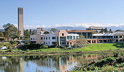
In addition to being a popular tourist and resort destination, the city economy includes a large service sector, education, technology, health care, finance, agriculture, manufacturing, and local government. In 2004, the service sector accounted for fully 35% of local employment. Education in particular is well-represented, with five institutions of higher learning on the south coast (the University of California, Santa Barbara
, Santa Barbara City College
, Westmont College
, Antioch University
, and the Brooks Institute of Photography
.) The Santa Barbara Airport
serves the city, as does Amtrak
. U.S. Highway 101
connects the Santa Barbara area with Los Angeles
to the south and San Francisco to the north. Behind the city, in and beyond the Santa Ynez Mountains, is the Los Padres National Forest
, which contains several remote wilderness areas.
in 1542, anchoring briefly in the area. In 1602 Sebastian Vizcaino
gave the name "Santa Barbara" to the region, in gratitude for having survived a violent storm in the Channel on December 3, the eve of the feast day of that saint
.
 A land expedition led by Gaspar de Portolá
and accompanied by missionary Padre Junipero Serra
visited in 1769, but did not stay. The first permanent European residents were Spanish missionaries and soldiers under Felipe de Neve
and again accompanied by Serra, who came in 1782 to build the Presidio and Mission. They were sent both to fortify the region against expansion by other powers such as England and Russia, and to convert the natives to Christianity. Many of the Spaniards brought their families with them, and those formed the nucleus of the small town – at first just a cluster of adobes – that surrounded the Presidio. Mission Santa Barbara was dedicated December 4, 1786, the feast day of Saint Barbara
. The Mission fathers began the slow work of converting the native Chumash to Christianity, building a village for them on the Mission grounds. Many of the natives died in the following decades of diseases such as smallpox to which they had no natural immunity.
The most dramatic event of the Spanish period was the powerful 1812 earthquake, and tsunami
, with an estimated magnitude of 7.1, which destroyed the Mission as well as the rest of the town; water reached as high as present-day Anapamu street, and carried a ship half a mile up Refugio Canyon. Following the earthquake, the Mission fathers chose to rebuild in a grander manner, and it is this construction that survives to the present day, the best-preserved of the California Missions.
The Spanish period ended in 1822 with the end of the Mexican War of Independence
, which terminated three hundred years of colonial rule. The flag of Mexico went up the flagpole at the Presidio, but only for 24 years.
, to various families in order to reward service or build alliances. These land grants to local notable families mark the beginning of the "Rancho Period" in California and Santa Barbara history. The population remained sparse, with enormous cattle operations run by wealthy families. It was during this period that Richard Henry Dana, Jr.
first visited Santa Barbara and wrote about the culture and people of Santa Barbara in his book Two Years Before the Mast
.
Santa Barbara fell bloodlessly to a battalion of American soldiers under John C. Frémont on December 27, 1846, during the Mexican-American War, and after the Treaty of Guadalupe Hidalgo
it became part of the expanding United States
.
had virtual control of the town in the early 1850s, until driven out by a posse organized in San Luis Obispo. English gradually supplanted Spanish as the language of daily life, becoming the language of official record in 1870. The first newspaper, the Santa Barbara Gazette, was founded in 1855.
While the Civil War
had little effect on Santa Barbara, the disastrous drought of 1863 ended the Rancho Period, as most of the cattle died and ranchos were broken up and sold. The building of Stearns Wharf
in 1872 enhanced Santa Barbara's commercial and tourist accessibility; previously goods and visitors had to transfer from steamboats to smaller craft to row ashore. During the 1870s, writer Charles Nordhoff promoted the town as a health resort and destination for well-to-do travelers from other parts of the U.S.; many of them came, and many stayed. The luxurious Arlington Hotel dated from this period. In 1887 the railroad finally went through to Los Angeles, and in 1901 to San Francisco: Santa Barbara was now easily accessible by land and by sea, and development was brisk.
Peter J. Barber
, an architect, designed many Late Victorian style residences, and served twice as mayor, in 1880 and again in 1890.
, and the region along the beach east of Santa Barbara sprouted numerous oil derricks and piers for drilling offshore
. This was the first offshore oil development in the world; oil drilling offshore would become a contentious practice in the Santa Barbara area to the present day.
Santa Barbara housed the world's largest movie studio during the era of silent film. Flying A Studios, a division of the American Film Manufacturing Company
, operated on two city blocks centered at State and Mission between 1910 and 1922, with the industry shutting down locally and moving to Hollywood once it outgrew the area, needing the resources of a larger city. Flying A and the other smaller local studios produced approximately 1,200 films during their tenure in Santa Barbara, of which approximately 100 survive.
During this period, the Loughead Aircraft Company
was established on lower State Street, and regularly tested seaplanes off of East Beach. This was the genesis of what would later become Lockheed
.
The earthquake of June 29, 1925, the first destructive earthquake in California since the 1906 San Francisco quake, destroyed much of Santa Barbara and killed 13 or 14 people. The low death toll is attributed to the early hour (6:23 a.m., before most people were out on the streets, vulnerable to falling masonry). While this quake, like the one in 1812, was centered in the Santa Barbara Channel, it caused no tsunami, and most of the damage was caused by two onshore aftershocks. It came at an opportune time for rebuilding, since a movement for architectural reform and unification around a Spanish Colonial style was already underway. Under the leadership of Pearl Chase, many of the city's famous buildings rose as part of the rebuilding process, including the Santa Barbara County Courthouse
, sometimes praised as the "most beautiful public building in the United States."
During World War II
Santa Barbara was home to Marine Corps Air Station Santa Barbara
; Naval Reserve Center Santa Barbara
at the harbor; was near to the Army's Camp Cook, present-day Vandenberg Air Force Base
; and contained a hospital for treating servicemen wounded in the Pacific Theatre. On February 23, 1942, not long after the outbreak of war in the Pacific, the Japanese submarine I-17
surfaced offshore and lobbed 16 shells
at the Ellwood Oil Field
, about 10 miles (16.1 km) west of Santa Barbara, in the first wartime attack by an enemy power on the U.S. mainland since the War of 1812. Although the shelling was inaccurate and only caused about $500 damage to a catwalk, panic was immediate. Many Santa Barbara residents fled, and land values plummeted to historic lows.
began supplying water via a tunnel dug through the mountains between 1950 and 1956.
Local relations with the oil industry gradually soured through the period. Production at Summerland had ended, Elwood was winding down, and to find new fields oil companies carried out seismic exploration of the Channel using explosives, a controversial practice that local fishermen claimed harmed their catch. The culminating disaster, and one of the formative events in the modern environmental movement, was the blowout at Union Oil's Platform A
on the Dos Cuadras Field
, about eight miles (13 km) southeast of Santa Barbara in the Santa Barbara Channel, on January 28, 1969. Approximately 100000 barrels (15,898,729.5 l) of oil surged out of a huge undersea break, fouling hundreds of square miles of ocean and all the coastline from Ventura to Goleta, as well north facing beaches on the Channel Islands. Two legislative consequences of the spill in the next year were the passages of the California Envirnomental Quality Act (CEQA) and the National Environmental Policy Act
(NEPA); locally, outraged citizens formed GOO (Get Oil Out).
Santa Barbara's business community strove to attract development until the surge in the anti-growth movement in the 1970s. Many "clean" industries, especially aerospace firms such as Raytheon and Delco Electronics, moved to town in the 1950s and 1960s, bringing employees from other parts of the U.S. UCSB itself became a major employer. In 1975, the city passed an ordinance restricting growth to a maximum of 85,000 residents, through zoning. Growth in the adjacent Goleta Valley could be shut down by denying water meters to developers seeking permits. As a result of these changes, growth slowed down, but prices rose sharply.
When voters approved connection to State water supplies in 1991, parts of the city, especially outlying areas, resumed growth, but more slowly than during the boom period of the 1950s and 1960s. While the slower growth preserved the quality of life for most residents and prevented the urban sprawl notorious in the Los Angeles basin, housing in the Santa Barbara area was in short supply, and prices soared: in 2006, only six percent of residents could afford a median-value house. As a result, many people who work in Santa Barbara commute from adjacent, more affordable areas, such as Santa Maria, Lompoc, and Ventura. The resultant traffic on incoming arteries, in particular the stretch of Highway 101 between Ventura and Santa Barbara, is another problem being addressed by long-range planners.
event; the November 2008 Tea Fire
, which destroyed 210 homes in the foothills of Santa Barbara and Montecito; and the 2009 Jesusita Fire
that burned 8733 acres (35.3 km²) and destroyed 80 homes above the San Roque region of Santa Barbara.
 Santa Barbara is located about 90 miles (145 km) WNW of Los Angeles
, along the Pacific
coast. This stretch of coast along southern Santa Barbara County
is often referred to as the "American Riviera" because its geography and similar climate to that of the French and Italian Rivieras. The Santa Ynez Mountains
, an east-west trending range, rise dramatically behind the city, with several peaks exceeding 4000 feet (1,219.2 m). Covered with chaparral
and with sandstone outcrops, they make a famously scenic backdrop to the town. Sometimes, perhaps once every three years, snow falls on the mountains, but it rarely stays for more than a few days. Nearer to town, and directly east and adjacent to Mission Santa Barbara
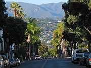
, is a hill known locally as the "Riviera," traversed by "Alameda Padre Serra" (shortened APS), "Father Serra's pathway." The hillside, made accessible by the advent of the automobile early in the 20th century, is now built with relatively expensive homes. A spectacularly beautiful area looking south toward the Pacific and the Channel Islands and having sunrise to sunset views, Santa Barbara became the winter destination for the titans of post-Civil War America. Private railroad cars clustered on the sidings at Santa Barbara. The Potter Hotel overlooking Santa Barbara's West Beach was a world renowned resort. Owners of industry visited Santa Barbara and chose Santa Barbara hillside locations for their grand estates. Others preferred the beach and built palatially there, from Sandyland Cove, Padaro Lane, the city beaches, and west to what is now Goleta.
According to the United States Census Bureau
, the city has a total area of 42 square miles (108.8 km²), of which 19.5 square miles (50.5 km²) of it is land and 22.5 square miles (58.3 km²) of it (53.61%) is water. The high official figures for water is due to the extension of the city limit into the ocean, including a strip of city reaching out into the sea and inland again to keep the Santa Barbara Airport (SBA) within the city boundary.
The architectural image of Santa Barbara is the Spanish Colonial Revival
style of architecture adopted by city leaders after the 1925 earthquake destroyed much of the downtown commercial district. The residential architecture of Santa Barbara is predominantly California bungalows
built in the early decades of the 20th century, with many Victorian homes adorning the "Upper East" and Spanish style homes designed by well-known California architects in Santa Barbara and on estates in Montecito and Hope Ranch. The city has passed ordinances against billboards and regulates outdoor advertising, so the city is relatively free of advertising clutter.
(Köppen climate classification
Csb) characteristic of coastal California. Because of the city's proximity to the ocean, onshore breezes significantly moderate temperatures, resulting in warmer winters and cooler summers. In addition, the Santa Ynez mountains create a rain shadow. As a result, Santa Barbara receives higher rainfall in the winter than other cities in the same area; summers are unaffected due to the presence of offshore high-pressure systems. Snow sometimes covers the Santa Ynez mountains but is totally unknown on the ground of the city. Only few flakes were recorded in 1939.
was 2,106.6 people per square mile (813.4/km²). The racial makeup of Santa Barbara was 66,411 (75.1%) White, 1,420 (1.6%) African American, 892 (1.0%) Native American, 3,062 (3.5%) Asian (1.0% Chinese, 0.6% Filipino, 0.5% Japanese, 0.4% Korean, 0.4% Indian, 0.2% Vietnamese, 0.4% Other), 116 (0.1%) Pacific Islander, 13,032 (14.7%) from other races
, and 3,477 (3.9%) from two or more races. Hispanic or Latino of any race were 33,591 persons (38.0%).
The Census reported that 86,783 people (98.2% of the population) lived in households, 1,172 (1.3%) lived in non-institutionalized group quarters, and 455 (0.5%) were institutionalized.
There were 35,449 households, out of which 8,768 (24.7%) had children under the age of 18 living in them, 13,240 (37.3%) were opposite-sex married couples
living together, 3,454 (9.7%) had a female householder with no husband present, 1,539 (4.3%) had a male householder with no wife present. There were 2,420 (6.8%) unmarried opposite-sex partnerships
, and 339 (1.0%) same-sex married couples or partnerships. 11,937 households (33.7%) were made up of individuals and 4,340 (12.2%) had someone living alone who was 65 years of age or older. The average household size was 2.45. There were 18,233 families
(51.4% of all households); the average family size was 3.13.
The population was spread out with 16,468 people (18.6%) under the age of 18, 10,823 people (12.2%) aged 18 to 24, 26,241 people (29.7%) aged 25 to 44, 22,305 people (25.2%) aged 45 to 64, and 12,573 people (14.2%) who were 65 years of age or older. The median age was 36.8 years. For every 100 females there were 98.5 males. For every 100 females age 18 and over, there were 97.7 males.
There were 37,820 housing units at an average density of 901.2 per square mile (347.9/km²), of which 13,784 (38.9%) were owner-occupied, and 21,665 (61.1%) were occupied by renters. The homeowner vacancy rate was 1.3%; the rental vacancy rate was 4.1%. 34,056 people (38.5% of the population) lived in owner-occupied housing units and 52,727 people (59.6%) lived in rental housing units.
of 2000, there were 92,325 people*, 35,605 households, and 18,941 families residing in the city. The population density
was 4,865.3 people per square mile (1,878.1/km²). There were 37,076 housing units at an average density of 1,953.8 per square mile (754.2/km²). The racial makeup of the city was 74.0% White, 1.8% African American, 1.1% Native American, 2.8% Asian, 0.1% Pacific Islander, 16.4% from other races
, and 3.9% from two or more races. People of Hispanic or Latino background, of any race, were 35.0% of the population. (*This number was revised to 89,600 when it was discovered that a dormitory population outside the city was erroneously included in the 92,325 figure.)
There were 35,605 households out of which 24.3% had children under the age of 18 living with them, 39.8% were married couples
living together, 9.5% had a female householder with no husband present, and 46.8% were non-families. 32.9% of all households were made up of individuals and 11.4% had someone living alone who was 65 years of age or older. The average household size was 2.47 and the average family size was 3.17.
In the city, the population was spread out, with 19.8% under the age of 18, 13.8% from 18 to 24, 32.3% from 25 to 44, 20.4% from 45 to 64, and 13.8% who were 65 years of age or older. The median age was 35 years. For every 100 females there were 97.0 males. For every 100 females age 18 and over, there were 95.0 males.
The median income
for a household in the city was $47,498, and the median income for a family was $57,880. Males had a median income of $37,116 versus $31,911 for females. The per capita income
for the city was $26,466. About 7.7% of families and 13.4% of the population were below the poverty line, including 16.8% of those under age 18 and 7.4% of those age 65 or over. If one compares the per capita income
to the actual cost of living, the number of people living below the poverty line is considerably higher.
was started in Santa Barbara in 1962. Science and technology, however, form the basis of the city's private employment. Firms like Alliant Techsystems
and Raytheon
have major operations near the city.
, a historic building and favorite venue for small concerts; the Granada Theater, the tallest building downtown, originally built by contractor C.B. Urton in 1924, but with the theatre remodeled and reopened in March 2008; and the Santa Barbara Bowl
, a 4,562 seat amphitheatre used for outdoor concerts, nestled in a picturesque canyon northwest of Santa Barbara at the base of the Riviera.
The city is considered a haven for classical music lovers with a symphony orchestra
and many non-profit classical music groups (such as CAMA
). The Music Academy of the West
, located in Montecito, hosts an annual music festival in the summer, drawing renowned students and professionals.
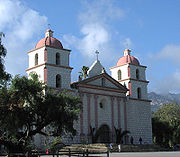
, "The Queen of the Missions," is located on a rise about two miles (3 km) inland from the harbor, and is maintained as an active place of worship, sightseeing stop, and national historic landmark
. The Santa Barbara County Courthouse
, a red tiled Spanish-Moorish structure, provides a sweeping view of the downtown area from its open air tower. The Presidio of Santa Barbara
, a Spanish military installation built in 1782, was central to the town's early development and remains an icon of the city's colonial roots.
Also famous is the annual Fiesta (originally called "Old Spanish Days"), which is celebrated every year in August. The Fiesta is hosted by the Native Daughters of the Golden West and the Native Sons of the Golden West in a joint committee called the Fiesta Board. Fiesta was originally started as a tourist attraction, like the Rose Bowl, to draw business into the town in the 1920s.
Flower Girls and Las Señoritas are another attraction of Fiesta, as they march and participate in both Fiesta Pequeña (the kickoff of Fiesta) and the various parades. Flower Girls is for girls under 13. They throw roses and other flowers into the crowds. Las Señoritas are their older escorts. Many Señoritas join the Native Daughters at the age of 16.
The annual Santa Barbara French Festival takes place Bastille Day weekend in July. This is the largest French Festival in the western United States.
For over 40 years, the Santa Barbara Arts and Crafts Show has been held on Cabrillo Blvd., east of Stearns Wharf
and along the beach, attracting thousands of people to see artwork made by artists and crafts people that live in Santa Barbara county. By the rules of the show, all the works displayed must have been made by the artists and craftspeople themselves, who must sell their own goods. The show started in the early 1960s, and now has over 200 booths varying in size and style on any Sunday of the year. The show is also held on some Saturdays that are national holidays, but not during inclement weather.
In recent years, the Santa Barbara International Film Festival
, another local non-profit, has also become a major draw bringing over 50,000 attendees during what is usually Santa Barbara's slow season in late January. SBIFF hosts a wide variety of celebrities, premieres, panels and movies from around the world and runs for 10 days.
The annual Summer Solstice Parade
draws up to 100,000 people. It is a colorful themed parade put on by local residents, and follows a route along State Street for approximately one mile, ending at Alameda Park
. Its main rule is that no written messages or banners with words are allowed. Floats and costumes vary from the whimsical to the outrageous; parties and street events take place throughout the weekend of the parade, the first weekend after the solstice.
Surfing is as much a part of Santa Barbara culture as Art. Three time world champion Tom Curren
, 10 time world champion Kelly Slater
, and other popular surf icons such as Jack Johnson
call Santa Barbara home. Local surfers are known for going north to The Point, or south to Rincon.
Other tourist-centered attractions include:
is home to a significant permanent collection. Other art venues include the University Art Museum
on the UC Santa Barbara Campus, various private galleries, and a wide variety of art and photography shows. The Santa Barbara Museum of Natural History
is located immediately behind the Santa Barbara Mission in a complex of Mission-style buildings set in a park-like campus. The Museum offers indoor and outdoor exhibits and a state-of-the-art planetarium. The Santa Barbara Contemporary Arts Forum, located on the top floor of Paseo Nuevo shopping mall, provides an arena for the presentation, documentation, and support of a broad variety of visual, media, and performing arts representing a wide range of attitudes. It offers free admission. The Santa Barbara Historical Museum is located on De La Guerra Street and offers free admission. The Santa Barbara Maritime Museum is located at 113 Harbor Way (the former Naval Reserve Center Santa Barbara
) on the waterfront. The Karpeles Manuscript Library Museum
(free admission) houses a collection of historical documents and manuscripts. Two open air museums here are Lotusland
and Casa del Herrero
, exemplifying the American Country Place era in Santa Barbara.
(sold by the New York Times Company
in 2000 to local resident Wendy P. McCaw
), with a circulation of about 25,000, and the Santa Barbara Independent
, a weekly with 40,000 audited circulation. The Santa Barbara Daily Sound
is an award-winning free daily newspaper publishing Tuesday through Saturday. Other media available include Edhat Online Magazine Edhat, an aggregation of citizen news and links to other media websites, the Santa Barbara View Santa Barbara View, an award-winning online magazine offering news, views, and commentary, Pacific Coast Business Times, a weekly business journal covering Santa Barbara, Ventura County and San Luis Obispo County http://www.pacbiztimes.com/; Santa Barbara Life http://www.sblife.com; Noozhawk, a local affairs website, Builder/Architect Gold & Central Coast Edition; and Shape of Voice http://www.shapeofvoice.com, a nonprofit youth-created publication that focuses on social justice and youth issues, and City 2.0, a local citizen blog network and news headline aggregation website. Local television stations include KEYT 3, an ABC
television affiliate; KPMR
38, a Univision
affiliate; Santa Barbara Internet TV http://www.sbitv.com, and Santa Barbara Channels; and 17 (Public-access television
) and 21 Arts & Education (formerly owned by Cox Communications
). Although Santa Barbara has radio stations including KJEE
(92.9 MHz), The Vibe:Hip Hop y Mas 103.3, KTYD
(99.9 MHz) and KLITE 101.7 owned by Rincon Broadcasing, some Los Angeles radio stations can be heard, although somewhat faintly due to the 85 miles (136.8 km) distance. Santa Monica-based NPR
radio station KCRW
can be heard in Santa Barbara at 106.9 MHz, and San Luis Obispo-based NPR station KCBX
at 89.5 MHz and 90.9 MHz. There is, however, an NPR station that has a news team in Santa Barbara, AM and FM Radio Towers in the county and covers stories, news and programming for the area, and that is KCLU (102.3 FM, 1340 AM). The only non-commercial radio station based in Santa Barbara is KCSB-FM, at 91.9 MHz, which is housed on the UC Santa Barbara campus and funded by the students of University of California, Santa Barbara
.
 Santa Barbara has many parks, ranging from small spaces within the urban environment to large, semi-wilderness areas that remain within the city limits. Some notable parks within the city limits are as follows:
Some notable parks and open spaces just outside of the city limits include:
 Santa Barbara and the immediately adjacent area is home to several colleges and universities:
and Hope district schools. There is also a variety of private schools in the area. The following schools are on the south coast of Santa Barbara County, including the cities of Santa Barbara, Goleta, Carpinteria, and contiguous unincorporated areas.
, an automotive transportation corridor that links the city to the rest of the Central Coast region, San Francisco to the north, and Los Angeles
to the south. The Santa Barbara Airport
offers commercial air service. Amtrak
offers rail service through the Coast Starlight
and Pacific Surfliner
trains at the train station on State Street. The Santa Barbara Metropolitan Transit District
(MTD) provides local bus service across the city, and Greyhound bus stations are located downtown. Electric shuttles operated by MTD ferry tourists and shoppers up and down lower State Street and to the wharf. Santa Barbara has an extensive network of bike trails and other resources for cyclists, and the League of American Bicyclists
recognizes Santa Barbara as a Silver Level city. Ventura Intercity Service Transit Authority
(VISTA) bus service offers connections south to Ventura and west to Goleta. The Clean Air Express bus offers connections to Lompoc and Santa Maria. Santa Barbara Airbus offers service to LAX from Santa Barbara and Goleta. In addition, Santa Barbara Car Free promotes visiting and exploring the area without use of a car.
's An American Family
, called Santa Barbara home since the early 1960s (moving there from Eugene, Oregon
) and throughout the series, all the family members save for Lance (who lived in New York City
at the time) were filmed going about their daily lives in Santa Barbara. Bill's foundry supply company was headquartered in downtown Santa Barbara.
In the ABC
television series Voyage to the Bottom of the Sea
, the fictional privately-owned nuclear-powered submarine Seaview
was based at the equally fictional Nelson Institute of Marine Research
located in Santa Barbara.
Several scenes in the 1966 film "Batman", starring Adam West and Burt Ward, were filmed on Stearns Wharf.
The final scene of the 1967 film The Graduate is set in Santa Barbara.
The Reggae band, Rebelution
, is from Santa Barbara.
The 1980s soap opera Santa Barbara
is set in Santa Barbara.
Santa Teresa
is a fictional version of Santa Barbara used in the mystery novels of Ross Macdonald
and Sue Grafton
.
The 1996 film My Favorite Martian
was filmed on location in Santa Barbara. The opening shot shows fictional TV station KGSC Channel 10 but KEYT Channel 3
was actually used for the filming location.
Establishing shots of several city vistas were used to represent Sunnydale in Buffy the Vampire Slayer.
The USA Network
television show Psych
features a fake psychic working for the Santa Barbara Police Department, however, the show is not filmed on location. It is filmed in Canada.
Hollywood couples including Fergie and Josh Duhamel
, Travis Barker
and Shanna Moakler, Jennie Garth
and Peter Facinelli and Charlie Sheen’s daughter, Casandra Estevez all celebrated their weddings at the Bacara Resort
in Santa Barbara.
The 2009 film It's Complicated
is set in Santa Barbara.
County seat
A county seat is an administrative center, or seat of government, for a county or civil parish. The term is primarily used in the United States....
of Santa Barbara County, California
Santa Barbara County, California
Santa Barbara County is a county located in the southern portion of the U.S. state of California, on the Pacific coast. As of 2010 the county had a population of 423,895. The county seat is Santa Barbara and the largest city is Santa Maria.-History:...
, United States
United States
The United States of America is a federal constitutional republic comprising fifty states and a federal district...
. Situated on an east-west trending section of coastline, the longest such section on the West Coast of the United States, the city lies between the steeply-rising Santa Ynez Mountains
Santa Ynez Mountains
The Santa Ynez Mountains are a portion of the Transverse Ranges, part of the Pacific Coast Ranges of the west coast of North America, and are one of the northernmost mountain ranges in Southern California.-Geography:...
and the Pacific Ocean
Pacific Ocean
The Pacific Ocean is the largest of the Earth's oceanic divisions. It extends from the Arctic in the north to the Southern Ocean in the south, bounded by Asia and Australia in the west, and the Americas in the east.At 165.2 million square kilometres in area, this largest division of the World...
. Santa Barbara's climate is often described as Mediterranean
Mediterranean climate
A Mediterranean climate is the climate typical of most of the lands in the Mediterranean Basin, and is a particular variety of subtropical climate...
, and the city is widely known as the "American Riviera." As of the census of 2010, the city had a population of 88,410, a loss of 1,190 from the previous census, making it the second largest city in the county after Santa Maria
Santa Maria, California
Santa Maria is a city in Santa Barbara County, on the Central Coast of California. The 2010 census population was 100,062, putting it ahead of Santa Barbara for the first time and making it the largest city in the county...
while the contiguous urban area, which includes the cities of Goleta
Goleta, California
Goleta is a city in southern Santa Barbara County, California, USA. It was incorporated as a city in 2002, after a long period as the largest unincorporated, populated area in the county. As of the 2000 census, the Census-designated place had a total population of 55,204, however, a significant...
and Carpinteria
Carpinteria, California
Carpinteria is a small oceanside city located in southeastern Santa Barbara County, California, east of Santa Barbara and northwest of Ventura. The population was 13,040 at the 2010 census, down from 14,194 at the 2000 census....
, along with the unincorporated regions of Isla Vista
Isla Vista, California
Isla Vista is an unincorporated community and census-designated place in Santa Barbara County, California in the United States. As of the 2010 census, it had a population of 23,096. The majority of residents are college students at nearby University of California, Santa Barbara or at Santa...
, Montecito
Montecito, California
Montecito is an unincorporated community in Santa Barbara County, California. As a census-designated place, it had a population of 8,965 in 2010. This does not include areas such as Coast Village Road, that, while usually considered part of Montecito, are actually within the city limits of Santa...
, Mission Canyon
Mission Canyon, California
Mission Canyon is a census-designated place and an unincorporated suburb of Santa Barbara, California, in Santa Barbara County, United States. The population was 2,381 at the 2010 census, down from 2,610 at the 2000 census....
, Hope Ranch
Hope Ranch, California
Hope Ranch is an unincorporated suburb of Santa Barbara, California, located in Santa Barbara County. As of the 2000 census, the area had an approximate population of 2,200. The ZIP codes are 93105 and 93110, and the community is in area code 805.-History:...
, Summerland
Summerland, California
Summerland is a census-designated place in Santa Barbara County, California, United States. The population was 1,448 at the 2010 census, down from 1,545 at the 2000 census.The town includes a school and a Presbyterian Church...
, and others, has an approximate current population of 220,000. The population of the entire county in 2010 was 423,895.
In addition to being a popular tourist and resort destination, the city economy includes a large service sector, education, technology, health care, finance, agriculture, manufacturing, and local government. In 2004, the service sector accounted for fully 35% of local employment. Education in particular is well-represented, with five institutions of higher learning on the south coast (the University of California, Santa Barbara
University of California, Santa Barbara
The University of California, Santa Barbara, commonly known as UCSB or UC Santa Barbara, is a public research university and one of the 10 general campuses of the University of California system. The main campus is located on a site in Goleta, California, from Santa Barbara and northwest of Los...
, Santa Barbara City College
Santa Barbara City College
Santa Barbara City College is a two-year community college founded in 1909. It is located on a campus right over the beach in the city of Santa Barbara, California, USA. SBCC offers associate degrees in English, Social Sciences, Computer Science, Engineering, Physics, and occupational and...
, Westmont College
Westmont College
Westmont offers 26 majors, including: alternative major, art, biology, chemistry, communication studies, computer science, economics and business, education program, engineering physics, English, history, European studies, kinesiology, liberal studies, mathematics, modern languages , music,...
, Antioch University
Antioch University
Antioch University is an American university with five campuses located in four states. Campuses are located in Los Angeles, California; Santa Barbara, California; Keene, New Hampshire; Yellow Springs, Ohio; and Seattle, Washington. Additionally, Antioch University houses two institution-wide...
, and the Brooks Institute of Photography
Brooks Institute of Photography
Brooks Institute is a system of two for-profit private arts colleges based in Santa Barbara, California and Ventura, California, owned by Career Education Corporation. Formally known as "Brooks Institute of Photography," Brooks Institute offers four majors, two certificate programs and two...
.) The Santa Barbara Airport
Santa Barbara Airport
Santa Barbara Airport , also known as Santa Barbara Municipal Airport, is a public airport located west of downtown Santa Barbara, California, United States....
serves the city, as does Amtrak
Amtrak
The National Railroad Passenger Corporation, doing business as Amtrak , is a government-owned corporation that was organized on May 1, 1971, to provide intercity passenger train service in the United States. "Amtrak" is a portmanteau of the words "America" and "track". It is headquartered at Union...
. U.S. Highway 101
U.S. Route 101
U.S. Route 101, or U.S. Highway 101, is an important north–south U.S. highway that runs through the states of California, Oregon, and Washington, on the West Coast of the United States...
connects the Santa Barbara area with Los Angeles
Los Ángeles
Los Ángeles is the capital of the province of Biobío, in the commune of the same name, in Region VIII , in the center-south of Chile. It is located between the Laja and Biobío rivers. The population is 123,445 inhabitants...
to the south and San Francisco to the north. Behind the city, in and beyond the Santa Ynez Mountains, is the Los Padres National Forest
Los Padres National Forest
Los Padres National Forest is a forest located in southern and central California, which includes most of the mountainous land along the California coast from Ventura to Monterey, extending inland...
, which contains several remote wilderness areas.
History
The history of the city begins at least 13,000 years ago with the ancestors of the present-day Chumash. Evidence for a Paleoindian presence includes a fluted Clovis-like point found in the 1980s along the western Santa Barbara County coast, as well as the remains of Arlington Springs Man, found on Santa Rosa Island in the 1960s. Approximately 8,000 to 10,000 Chumash lived on the south coast of Santa Barbara County when Portuguese explorer João Cabrilho sailed through the Santa Barbara ChannelSanta Barbara Channel
The Santa Barbara Channel is a portion of the Pacific Ocean which separates the mainland of California from the northern Channel Islands. It is generally south of the city of Santa Barbara, and west of the city of Ventura....
in 1542, anchoring briefly in the area. In 1602 Sebastian Vizcaino
Sebastián Vizcaíno
Sebastián Vizcaíno was a Spanish soldier, entrepreneur, explorer, and diplomat whose varied roles took him to New Spain, the Philippines, the Baja California peninsula, the California coast and Japan.-Early career:...
gave the name "Santa Barbara" to the region, in gratitude for having survived a violent storm in the Channel on December 3, the eve of the feast day of that saint
Saint Barbara
Saint Barbara, , Feast Day December 4, known in the Eastern Orthodox Church as the Great Martyr Barbara, was an early Christian saint and martyr....
.
Spanish period
Gaspar de Portolà
Gaspar de Portolà i Rovira was a soldier, governor of Baja and Alta California , explorer and founder of San Diego and Monterey. He was born in Os de Balaguer, province of Lleida, in Catalonia, Spain, of Catalan nobility. Don Gaspar served as a soldier in the Spanish army in Italy and Portugal...
and accompanied by missionary Padre Junipero Serra
Junípero Serra
Blessed Junípero Serra, O.F.M., , known as Fra Juníper Serra in Catalan, his mother tongue was a Majorcan Franciscan friar who founded the mission chain in Alta California of the Las Californias Province in New Spain—present day California, United States. Fr...
visited in 1769, but did not stay. The first permanent European residents were Spanish missionaries and soldiers under Felipe de Neve
Felipe de Neve
Felipe de Neve was a Spanish governor of Las Californias, an area that included present-day California , Baja California and Baja California Sur . His tenure as governor was from 1775 to 1782...
and again accompanied by Serra, who came in 1782 to build the Presidio and Mission. They were sent both to fortify the region against expansion by other powers such as England and Russia, and to convert the natives to Christianity. Many of the Spaniards brought their families with them, and those formed the nucleus of the small town – at first just a cluster of adobes – that surrounded the Presidio. Mission Santa Barbara was dedicated December 4, 1786, the feast day of Saint Barbara
Saint Barbara
Saint Barbara, , Feast Day December 4, known in the Eastern Orthodox Church as the Great Martyr Barbara, was an early Christian saint and martyr....
. The Mission fathers began the slow work of converting the native Chumash to Christianity, building a village for them on the Mission grounds. Many of the natives died in the following decades of diseases such as smallpox to which they had no natural immunity.
The most dramatic event of the Spanish period was the powerful 1812 earthquake, and tsunami
Tsunami
A tsunami is a series of water waves caused by the displacement of a large volume of a body of water, typically an ocean or a large lake...
, with an estimated magnitude of 7.1, which destroyed the Mission as well as the rest of the town; water reached as high as present-day Anapamu street, and carried a ship half a mile up Refugio Canyon. Following the earthquake, the Mission fathers chose to rebuild in a grander manner, and it is this construction that survives to the present day, the best-preserved of the California Missions.
The Spanish period ended in 1822 with the end of the Mexican War of Independence
Mexican War of Independence
The Mexican War of Independence was an armed conflict between the people of Mexico and the Spanish colonial authorities which started on 16 September 1810. The movement, which became known as the Mexican War of Independence, was led by Mexican-born Spaniards, Mestizos and Amerindians who sought...
, which terminated three hundred years of colonial rule. The flag of Mexico went up the flagpole at the Presidio, but only for 24 years.
Mexican and Rancho period
After the forced secularization of the Missions in 1833, the large land tracts formerly held by the Franciscan Order were distributed by the Mexican governor of California, Pio PicoPío Pico
Pío de Jesús Pico was the last Governor of Alta California under Mexican rule.-Origins:...
, to various families in order to reward service or build alliances. These land grants to local notable families mark the beginning of the "Rancho Period" in California and Santa Barbara history. The population remained sparse, with enormous cattle operations run by wealthy families. It was during this period that Richard Henry Dana, Jr.
Richard Henry Dana, Jr.
Richard Henry Dana Jr. was an American lawyer and politician from Massachusetts, a descendant of an eminent colonial family who gained renown as the author of the American classic, the memoir Two Years Before the Mast...
first visited Santa Barbara and wrote about the culture and people of Santa Barbara in his book Two Years Before the Mast
Two Years Before the Mast
Two Years Before the Mast is a book by the American author Richard Henry Dana, Jr., published in 1840, having been written after a two-year sea voyage starting in 1834. A film adaptation under the same name was released in 1946.- Background :...
.
Santa Barbara fell bloodlessly to a battalion of American soldiers under John C. Frémont on December 27, 1846, during the Mexican-American War, and after the Treaty of Guadalupe Hidalgo
Treaty of Guadalupe Hidalgo
The Treaty of Guadalupe Hidalgo is the peace treaty, largely dictated by the United States to the interim government of a militarily occupied Mexico City, that ended the Mexican-American War on February 2, 1848...
it became part of the expanding United States
United States
The United States of America is a federal constitutional republic comprising fifty states and a federal district...
.
Middle and late 19th century
Change came quickly after Santa Barbara's acquisition by the United States. The population doubled between 1850 and 1860. In 1851, land surveyor Salisbury Haley designed the street grid, famously botching the block measurements, misaligning the streets; wood construction replaced adobe, as American settlers moved in; and during the Gold Rush years and following, the town became a haven for bandits and gamblers, and a dangerous and lawless place. Charismatic gambler and highwayman Jack PowersJack Powers
Jack Powers was an Irish-American gambler, outlaw, highway-robber, gang leader, and murderer in southern and central California during the Gold Rush era...
had virtual control of the town in the early 1850s, until driven out by a posse organized in San Luis Obispo. English gradually supplanted Spanish as the language of daily life, becoming the language of official record in 1870. The first newspaper, the Santa Barbara Gazette, was founded in 1855.
While the Civil War
American Civil War
The American Civil War was a civil war fought in the United States of America. In response to the election of Abraham Lincoln as President of the United States, 11 southern slave states declared their secession from the United States and formed the Confederate States of America ; the other 25...
had little effect on Santa Barbara, the disastrous drought of 1863 ended the Rancho Period, as most of the cattle died and ranchos were broken up and sold. The building of Stearns Wharf
Stearns Wharf
Stearns Wharf is a pier in the harbor at Santa Barbara, California, USA. When completed In 1872, it became the longest deep-water pier between Los Angeles and San Francisco. Named for its builder, local lumberman John P...
in 1872 enhanced Santa Barbara's commercial and tourist accessibility; previously goods and visitors had to transfer from steamboats to smaller craft to row ashore. During the 1870s, writer Charles Nordhoff promoted the town as a health resort and destination for well-to-do travelers from other parts of the U.S.; many of them came, and many stayed. The luxurious Arlington Hotel dated from this period. In 1887 the railroad finally went through to Los Angeles, and in 1901 to San Francisco: Santa Barbara was now easily accessible by land and by sea, and development was brisk.
Peter J. Barber
Peter J. Barber
Peter J. Barber was an architect and served as mayor of Santa Barbara, California. He to San Francisco in 1852, from Ohio, via Panama. He served as mayor of Santa Barbara during 1880-1881 and 1890-1891....
, an architect, designed many Late Victorian style residences, and served twice as mayor, in 1880 and again in 1890.
Early 20th century to World War II
Just before the turn of the century, oil was discovered at the Summerland Oil FieldSummerland Oil Field
The Summerland Oil Field is an inactive oil field in Santa Barbara County, California, about four miles east of the city of Santa Barbara, within and next to the unincorporated community of Summerland...
, and the region along the beach east of Santa Barbara sprouted numerous oil derricks and piers for drilling offshore
Offshore drilling
Offshore drilling refers to a mechanical process where a wellbore is drilled through the seabed. It is typically carried out in order to explore for and subsequently produce hydrocarbons which lie in rock formations beneath the seabed...
. This was the first offshore oil development in the world; oil drilling offshore would become a contentious practice in the Santa Barbara area to the present day.
Santa Barbara housed the world's largest movie studio during the era of silent film. Flying A Studios, a division of the American Film Manufacturing Company
American Film Manufacturing Company
The American Film Manufacturing Company, also known as Flying "A" Studios, was founded in Chicago in fall 1910. In 1915, the formal name was changed to the American Film Company....
, operated on two city blocks centered at State and Mission between 1910 and 1922, with the industry shutting down locally and moving to Hollywood once it outgrew the area, needing the resources of a larger city. Flying A and the other smaller local studios produced approximately 1,200 films during their tenure in Santa Barbara, of which approximately 100 survive.
During this period, the Loughead Aircraft Company
Alco Hydro-Aeroplane Company
The Alco Hydro-Aeroplane Company was formed by brothers Malcolm Loughead and Allan Loughead in 1912 in Santa Barbara, CA. The company later went on to become the Lockheed Corporation....
was established on lower State Street, and regularly tested seaplanes off of East Beach. This was the genesis of what would later become Lockheed
Lockheed Corporation
The Lockheed Corporation was an American aerospace company. Lockheed was founded in 1912 and later merged with Martin Marietta to form Lockheed Martin in 1995.-Origins:...
.
The earthquake of June 29, 1925, the first destructive earthquake in California since the 1906 San Francisco quake, destroyed much of Santa Barbara and killed 13 or 14 people. The low death toll is attributed to the early hour (6:23 a.m., before most people were out on the streets, vulnerable to falling masonry). While this quake, like the one in 1812, was centered in the Santa Barbara Channel, it caused no tsunami, and most of the damage was caused by two onshore aftershocks. It came at an opportune time for rebuilding, since a movement for architectural reform and unification around a Spanish Colonial style was already underway. Under the leadership of Pearl Chase, many of the city's famous buildings rose as part of the rebuilding process, including the Santa Barbara County Courthouse
Santa Barbara County Courthouse
The Santa Barbara County Courthouse is located at 1100 Anacapa Street, Santa Barbara, California. Designed by William Mooser III and completed in 1929, the Spanish Colonial Revival style building replaced the smaller Greek Revival courthouse of the same location...
, sometimes praised as the "most beautiful public building in the United States."
During World War II
World War II
World War II, or the Second World War , was a global conflict lasting from 1939 to 1945, involving most of the world's nations—including all of the great powers—eventually forming two opposing military alliances: the Allies and the Axis...
Santa Barbara was home to Marine Corps Air Station Santa Barbara
Marine Corps Air Station Santa Barbara
'Marine Corps Air Station Santa Barbara was a United States Marine Corps air station that was located in Goleta, California north of Los Angeles during World War II...
; Naval Reserve Center Santa Barbara
Naval Reserve Center Santa Barbara
In 1897, a small group of Santa Barbara, California citizens organized the Sixth Division of the California Naval militia to provide coastal defense for the central coast area. In those days, the Division conducted drills, knotting and splicing exercises, and trained on their gunnery skills aboard...
at the harbor; was near to the Army's Camp Cook, present-day Vandenberg Air Force Base
Vandenberg Air Force Base
Vandenberg Air Force Base is a United States Air Force Base, located approximately northwest of Lompoc, California. It is under the jurisdiction of the 30th Space Wing, Air Force Space Command ....
; and contained a hospital for treating servicemen wounded in the Pacific Theatre. On February 23, 1942, not long after the outbreak of war in the Pacific, the Japanese submarine I-17
Japanese submarine I-17
I-17 was a Japanese B1 type submarine of the Imperial Japanese Navy which saw service during World War II. She was the first Axis ship to shell the United States mainland.-Pearl Harbor:...
surfaced offshore and lobbed 16 shells
Bombardment of Ellwood
The Bombardment of Ellwood during World War II was a naval attack by a Japanese submarine against United States coastal targets near Santa Barbara, California. Though damage was minimal, the event was key in triggering the West Coast invasion scare and influenced the decision to intern...
at the Ellwood Oil Field
Ellwood Oil Field
Ellwood Oil Field and South Ellwood Offshore Oil Field are a pair of adjacent, partially active oil fields adjoining the city of Goleta, California, about twelve miles west of Santa Barbara, largely in the Santa Barbara Channel...
, about 10 miles (16.1 km) west of Santa Barbara, in the first wartime attack by an enemy power on the U.S. mainland since the War of 1812. Although the shelling was inaccurate and only caused about $500 damage to a catwalk, panic was immediate. Many Santa Barbara residents fled, and land values plummeted to historic lows.
After World War II
After the war many of the servicemen who had seen Santa Barbara returned to stay. The population surged by 10,000 people between the end of the war and 1950. This burst of growth had dramatic consequences for the local economy and infrastructure. Highway 101 was built through town during this period, and newly built Lake CachumaLake Cachuma
Lake Cachuma is an artificial lake located in the Santa Ynez Valley of central Santa Barbara County, California on the Santa Ynez River adjoining the north side of California State Route 154. The reservoir was created by the construction of Bradbury Dam, a earth-fill structure built by the U.S....
began supplying water via a tunnel dug through the mountains between 1950 and 1956.
Local relations with the oil industry gradually soured through the period. Production at Summerland had ended, Elwood was winding down, and to find new fields oil companies carried out seismic exploration of the Channel using explosives, a controversial practice that local fishermen claimed harmed their catch. The culminating disaster, and one of the formative events in the modern environmental movement, was the blowout at Union Oil's Platform A
1969 Santa Barbara oil spill
The Santa Barbara oil spill occurred in January and February 1969 in the Santa Barbara Channel, near the city of Santa Barbara in Southern California. It was the largest oil spill in United States waters at the time, and now ranks third after the 2010 Deepwater Horizon and 1989 Exxon Valdez spills...
on the Dos Cuadras Field
Dos Cuadras Offshore Oil Field
The Dos Cuadras Offshore Oil Field is a large oil and gas field underneath the Santa Barbara Channel about eight miles southeast of Santa Barbara, California. Discovered in 1968, and with a cumulative production of over 260 million barrels of oil, it is the 24th-largest oil field within California...
, about eight miles (13 km) southeast of Santa Barbara in the Santa Barbara Channel, on January 28, 1969. Approximately 100000 barrels (15,898,729.5 l) of oil surged out of a huge undersea break, fouling hundreds of square miles of ocean and all the coastline from Ventura to Goleta, as well north facing beaches on the Channel Islands. Two legislative consequences of the spill in the next year were the passages of the California Envirnomental Quality Act (CEQA) and the National Environmental Policy Act
National Environmental Policy Act
The National Environmental Policy Act is a United States environmental law that established a U.S. national policy promoting the enhancement of the environment and also established the President's Council on Environmental Quality ....
(NEPA); locally, outraged citizens formed GOO (Get Oil Out).
Santa Barbara's business community strove to attract development until the surge in the anti-growth movement in the 1970s. Many "clean" industries, especially aerospace firms such as Raytheon and Delco Electronics, moved to town in the 1950s and 1960s, bringing employees from other parts of the U.S. UCSB itself became a major employer. In 1975, the city passed an ordinance restricting growth to a maximum of 85,000 residents, through zoning. Growth in the adjacent Goleta Valley could be shut down by denying water meters to developers seeking permits. As a result of these changes, growth slowed down, but prices rose sharply.
When voters approved connection to State water supplies in 1991, parts of the city, especially outlying areas, resumed growth, but more slowly than during the boom period of the 1950s and 1960s. While the slower growth preserved the quality of life for most residents and prevented the urban sprawl notorious in the Los Angeles basin, housing in the Santa Barbara area was in short supply, and prices soared: in 2006, only six percent of residents could afford a median-value house. As a result, many people who work in Santa Barbara commute from adjacent, more affordable areas, such as Santa Maria, Lompoc, and Ventura. The resultant traffic on incoming arteries, in particular the stretch of Highway 101 between Ventura and Santa Barbara, is another problem being addressed by long-range planners.
Notable wildfires
Several destructive fires affected Santa Barbara during this time: the 1964 Coyote Fire, which burned 67000 acres (271.1 km²) of backcountry along with 150 homes; the smaller but quickly moving Sycamore Fire in 1977, which burned 200 homes; the disastrous 1990 Painted Cave Fire, which incinerated over 500 homes in only several hours, during an intense Sundowner windSundowner (wind)
A sundowner is an offshore northerly Foehn wind in Santa Barbara, California. It occurs when a region of high pressure is directly north of the area, whose coast trends east–west. This contrasts with the more typical onshore flow...
event; the November 2008 Tea Fire
Montecito Tea Fire
The Montecito Tea Fire is a wildfire that began on November 13, 2008, destroying 210 homes in the cities of Montecito and Santa Barbara, California in the United States of America. It was the first of several November 2008 wildfires that burned hundreds of homes November 13–15, 2008...
, which destroyed 210 homes in the foothills of Santa Barbara and Montecito; and the 2009 Jesusita Fire
Jesusita Fire
The Jesusita Fire was a wildfire that began at approximately 1:45 PM on May 5, 2009 in the hills of Santa Barbara, California. The fire burned , destroyed 80 homes and damaged 15 more before being 100% contained....
that burned 8733 acres (35.3 km²) and destroyed 80 homes above the San Roque region of Santa Barbara.
Geography
Los Angeles, California
Los Angeles , with a population at the 2010 United States Census of 3,792,621, is the most populous city in California, USA and the second most populous in the United States, after New York City. It has an area of , and is located in Southern California...
, along the Pacific
Pacific Ocean
The Pacific Ocean is the largest of the Earth's oceanic divisions. It extends from the Arctic in the north to the Southern Ocean in the south, bounded by Asia and Australia in the west, and the Americas in the east.At 165.2 million square kilometres in area, this largest division of the World...
coast. This stretch of coast along southern Santa Barbara County
Santa Barbara County, California
Santa Barbara County is a county located in the southern portion of the U.S. state of California, on the Pacific coast. As of 2010 the county had a population of 423,895. The county seat is Santa Barbara and the largest city is Santa Maria.-History:...
is often referred to as the "American Riviera" because its geography and similar climate to that of the French and Italian Rivieras. The Santa Ynez Mountains
Santa Ynez Mountains
The Santa Ynez Mountains are a portion of the Transverse Ranges, part of the Pacific Coast Ranges of the west coast of North America, and are one of the northernmost mountain ranges in Southern California.-Geography:...
, an east-west trending range, rise dramatically behind the city, with several peaks exceeding 4000 feet (1,219.2 m). Covered with chaparral
Chaparral
Chaparral is a shrubland or heathland plant community found primarily in the U.S. state of California and in the northern portion of the Baja California peninsula, Mexico...
and with sandstone outcrops, they make a famously scenic backdrop to the town. Sometimes, perhaps once every three years, snow falls on the mountains, but it rarely stays for more than a few days. Nearer to town, and directly east and adjacent to Mission Santa Barbara
Mission Santa Barbara
In 1840, Alta California and Baja California were removed from the Diocese of Sonora to form the Diocese of Both Californias. Bishop Francisco Garcia Diego y Moreno, OFM, established his cathedra at Mission Santa Barbara, making the chapel the pro-cathedral of the diocese until 1849...
, is a hill known locally as the "Riviera," traversed by "Alameda Padre Serra" (shortened APS), "Father Serra's pathway." The hillside, made accessible by the advent of the automobile early in the 20th century, is now built with relatively expensive homes. A spectacularly beautiful area looking south toward the Pacific and the Channel Islands and having sunrise to sunset views, Santa Barbara became the winter destination for the titans of post-Civil War America. Private railroad cars clustered on the sidings at Santa Barbara. The Potter Hotel overlooking Santa Barbara's West Beach was a world renowned resort. Owners of industry visited Santa Barbara and chose Santa Barbara hillside locations for their grand estates. Others preferred the beach and built palatially there, from Sandyland Cove, Padaro Lane, the city beaches, and west to what is now Goleta.
According to the United States Census Bureau
United States Census Bureau
The United States Census Bureau is the government agency that is responsible for the United States Census. It also gathers other national demographic and economic data...
, the city has a total area of 42 square miles (108.8 km²), of which 19.5 square miles (50.5 km²) of it is land and 22.5 square miles (58.3 km²) of it (53.61%) is water. The high official figures for water is due to the extension of the city limit into the ocean, including a strip of city reaching out into the sea and inland again to keep the Santa Barbara Airport (SBA) within the city boundary.
The architectural image of Santa Barbara is the Spanish Colonial Revival
Spanish Colonial Revival Style architecture
The Spanish Colonial Revival Style was a United States architectural stylistic movement that came about in the early 20th century, starting in California and Florida as a regional expression related to history, environment, and nostalgia...
style of architecture adopted by city leaders after the 1925 earthquake destroyed much of the downtown commercial district. The residential architecture of Santa Barbara is predominantly California bungalows
California Bungalow
California bungalows, known as Californian bungalows in Australia and are commonly called simply bungalows in America, are a form of residential structure that were widely popular across America and, to some extent, the world around the years 1910 to 1939.-Exterior features:Bungalows are 1 or 1½...
built in the early decades of the 20th century, with many Victorian homes adorning the "Upper East" and Spanish style homes designed by well-known California architects in Santa Barbara and on estates in Montecito and Hope Ranch. The city has passed ordinances against billboards and regulates outdoor advertising, so the city is relatively free of advertising clutter.
Climate
Santa Barbara experiences a cool Mediterranean climateMediterranean climate
A Mediterranean climate is the climate typical of most of the lands in the Mediterranean Basin, and is a particular variety of subtropical climate...
(Köppen climate classification
Köppen climate classification
The Köppen climate classification is one of the most widely used climate classification systems. It was first published by Crimea German climatologist Wladimir Köppen in 1884, with several later modifications by Köppen himself, notably in 1918 and 1936...
Csb) characteristic of coastal California. Because of the city's proximity to the ocean, onshore breezes significantly moderate temperatures, resulting in warmer winters and cooler summers. In addition, the Santa Ynez mountains create a rain shadow. As a result, Santa Barbara receives higher rainfall in the winter than other cities in the same area; summers are unaffected due to the presence of offshore high-pressure systems. Snow sometimes covers the Santa Ynez mountains but is totally unknown on the ground of the city. Only few flakes were recorded in 1939.
2010
The 2010 United States Census reported that Santa Barbara had a population of 88,410. The population densityPopulation density
Population density is a measurement of population per unit area or unit volume. It is frequently applied to living organisms, and particularly to humans...
was 2,106.6 people per square mile (813.4/km²). The racial makeup of Santa Barbara was 66,411 (75.1%) White, 1,420 (1.6%) African American, 892 (1.0%) Native American, 3,062 (3.5%) Asian (1.0% Chinese, 0.6% Filipino, 0.5% Japanese, 0.4% Korean, 0.4% Indian, 0.2% Vietnamese, 0.4% Other), 116 (0.1%) Pacific Islander, 13,032 (14.7%) from other races
Race (United States Census)
Race and ethnicity in the United States Census, as defined by the Federal Office of Management and Budget and the United States Census Bureau, are self-identification data items in which residents choose the race or races with which they most closely identify, and indicate whether or not they are...
, and 3,477 (3.9%) from two or more races. Hispanic or Latino of any race were 33,591 persons (38.0%).
The Census reported that 86,783 people (98.2% of the population) lived in households, 1,172 (1.3%) lived in non-institutionalized group quarters, and 455 (0.5%) were institutionalized.
There were 35,449 households, out of which 8,768 (24.7%) had children under the age of 18 living in them, 13,240 (37.3%) were opposite-sex married couples
Marriage
Marriage is a social union or legal contract between people that creates kinship. It is an institution in which interpersonal relationships, usually intimate and sexual, are acknowledged in a variety of ways, depending on the culture or subculture in which it is found...
living together, 3,454 (9.7%) had a female householder with no husband present, 1,539 (4.3%) had a male householder with no wife present. There were 2,420 (6.8%) unmarried opposite-sex partnerships
POSSLQ
POSSLQ is an abbreviation for "Persons of Opposite Sex Sharing Living Quarters," a term coined in the late 1970s by the United States Census Bureau as part of an effort to more accurately gauge the prevalence of cohabitation in American households....
, and 339 (1.0%) same-sex married couples or partnerships. 11,937 households (33.7%) were made up of individuals and 4,340 (12.2%) had someone living alone who was 65 years of age or older. The average household size was 2.45. There were 18,233 families
Family (U.S. Census)
A family or family household is defined by the United States Census Bureau for statistical purposes as "a householder and one or more other people related to the householder by birth, marriage, or adoption. They do not include same-sex married couples even if the marriage was performed in a state...
(51.4% of all households); the average family size was 3.13.
The population was spread out with 16,468 people (18.6%) under the age of 18, 10,823 people (12.2%) aged 18 to 24, 26,241 people (29.7%) aged 25 to 44, 22,305 people (25.2%) aged 45 to 64, and 12,573 people (14.2%) who were 65 years of age or older. The median age was 36.8 years. For every 100 females there were 98.5 males. For every 100 females age 18 and over, there were 97.7 males.
There were 37,820 housing units at an average density of 901.2 per square mile (347.9/km²), of which 13,784 (38.9%) were owner-occupied, and 21,665 (61.1%) were occupied by renters. The homeowner vacancy rate was 1.3%; the rental vacancy rate was 4.1%. 34,056 people (38.5% of the population) lived in owner-occupied housing units and 52,727 people (59.6%) lived in rental housing units.
2000
As of the censusCensus
A census is the procedure of systematically acquiring and recording information about the members of a given population. It is a regularly occurring and official count of a particular population. The term is used mostly in connection with national population and housing censuses; other common...
of 2000, there were 92,325 people*, 35,605 households, and 18,941 families residing in the city. The population density
Population density
Population density is a measurement of population per unit area or unit volume. It is frequently applied to living organisms, and particularly to humans...
was 4,865.3 people per square mile (1,878.1/km²). There were 37,076 housing units at an average density of 1,953.8 per square mile (754.2/km²). The racial makeup of the city was 74.0% White, 1.8% African American, 1.1% Native American, 2.8% Asian, 0.1% Pacific Islander, 16.4% from other races
Race (United States Census)
Race and ethnicity in the United States Census, as defined by the Federal Office of Management and Budget and the United States Census Bureau, are self-identification data items in which residents choose the race or races with which they most closely identify, and indicate whether or not they are...
, and 3.9% from two or more races. People of Hispanic or Latino background, of any race, were 35.0% of the population. (*This number was revised to 89,600 when it was discovered that a dormitory population outside the city was erroneously included in the 92,325 figure.)
There were 35,605 households out of which 24.3% had children under the age of 18 living with them, 39.8% were married couples
Marriage
Marriage is a social union or legal contract between people that creates kinship. It is an institution in which interpersonal relationships, usually intimate and sexual, are acknowledged in a variety of ways, depending on the culture or subculture in which it is found...
living together, 9.5% had a female householder with no husband present, and 46.8% were non-families. 32.9% of all households were made up of individuals and 11.4% had someone living alone who was 65 years of age or older. The average household size was 2.47 and the average family size was 3.17.
In the city, the population was spread out, with 19.8% under the age of 18, 13.8% from 18 to 24, 32.3% from 25 to 44, 20.4% from 45 to 64, and 13.8% who were 65 years of age or older. The median age was 35 years. For every 100 females there were 97.0 males. For every 100 females age 18 and over, there were 95.0 males.
The median income
Income
Income is the consumption and savings opportunity gained by an entity within a specified time frame, which is generally expressed in monetary terms. However, for households and individuals, "income is the sum of all the wages, salaries, profits, interests payments, rents and other forms of earnings...
for a household in the city was $47,498, and the median income for a family was $57,880. Males had a median income of $37,116 versus $31,911 for females. The per capita income
Per capita income
Per capita income or income per person is a measure of mean income within an economic aggregate, such as a country or city. It is calculated by taking a measure of all sources of income in the aggregate and dividing it by the total population...
for the city was $26,466. About 7.7% of families and 13.4% of the population were below the poverty line, including 16.8% of those under age 18 and 7.4% of those age 65 or over. If one compares the per capita income
Per capita income
Per capita income or income per person is a measure of mean income within an economic aggregate, such as a country or city. It is calculated by taking a measure of all sources of income in the aggregate and dividing it by the total population...
to the actual cost of living, the number of people living below the poverty line is considerably higher.
Economy
Santa Barbara's many tourist attractions have made the hospitality industry into a major player in the regional economy. For example, Motel 6Motel 6
Motel 6 is a major chain of budget motels with more than 1,000 locations in the United States and Canada, and is the largest owned and operated hotel chain in North America. It is owned and operated by Accor Hotels.-History:...
was started in Santa Barbara in 1962. Science and technology, however, form the basis of the city's private employment. Firms like Alliant Techsystems
Alliant Techsystems
Alliant Techsystems Inc., most commonly known by its ticker symbol, ', is one of the largest aerospace and defense companies in the United States with more than 18,000 employees in 22 states, Puerto Rico and internationally, and 2010 revenues in excess of an estimated...
and Raytheon
Raytheon
Raytheon Company is a major American defense contractor and industrial corporation with core manufacturing concentrations in weapons and military and commercial electronics. It was previously involved in corporate and special-mission aircraft until early 2007...
have major operations near the city.
Top employers
According to the City's 2010 Comprehensive Annual Financial Report, the top employers in South Santa Barbara County are:| # | Employer | # of Employees |
|---|---|---|
| 1 | University of California, Santa Barbara University of California, Santa Barbara The University of California, Santa Barbara, commonly known as UCSB or UC Santa Barbara, is a public research university and one of the 10 general campuses of the University of California system. The main campus is located on a site in Goleta, California, from Santa Barbara and northwest of Los... |
6,200 |
| 2 | County of Santa Barbara | 4,000 |
| 3 | Santa Barbara Cottage Hospital Santa Barbara Cottage Hospital Santa Barbara Cottage Hospital is a hospital in the city of Santa Barbara, California. It is owned and operated by Cottage Health System.It is the only Level II trauma center between Los Angeles and the Bay Area on coastal California... |
2,500 |
| 4 | Santa Barbara City College Santa Barbara City College Santa Barbara City College is a two-year community college founded in 1909. It is located on a campus right over the beach in the city of Santa Barbara, California, USA. SBCC offers associate degrees in English, Social Sciences, Computer Science, Engineering, Physics, and occupational and... |
2,000 |
| 5 | Santa Barbara School Districts Santa Barbara School Districts The Santa Barbara School Districts is the main public school district that serves Santa Barbara, California. Its high school system serves Goleta as well. The district consists of one administrative system and school board wrapped around two different elementary and secondary "districts" which... |
1,800 |
| 6 | Raytheon Raytheon Space and Airborne Systems Raytheon Space and Airborne Systems is a major business segment of Raytheon. Headquartered in El Segundo, California, SAS has a total employment of 12,000 and 2010 sales of US$ 4.8 billion. Rick Yuse is the segment's President... |
1,500 |
| 7 | Sansum Clinic | 1,500 |
| 8 | City of Santa Barbara | 1,000 |
| 9 | United States Postal Service United States Postal Service The United States Postal Service is an independent agency of the United States government responsible for providing postal service in the United States... |
1,000 |
| 10 | Santa Barbara Bank & Trust Santa Barbara Bank & Trust Pacific Capital Bancorp operates 49 branches between Los Angeles, California and San Jose, California under the name Santa Barbara Bank & Trust. Pacific Capital Bancorp also owns Morton Capital Management and RE Wacker & Associates... |
950 |
Neighborhoods
As with most cities, Santa Barbara has a range of neighborhoods with distinctive histories, architectures, and cultures. While considerable consensus exists as to the identification of neighborhood names and boundaries, variations exist between observers. For example, real estate agents may use different names than those used by public utilities or municipal service providers, such as police, fire, or water services. The following is a list of neighborhoods with descriptions and comments on each.- The Mesa stretches 2.5 miles (4 km) from Santa Barbara City College on the east to Arroyo Burro County Beach (or "Hendry’s/The Pit" to locals) on the west. This is considered to be a desirable neighborhood due to its proximity to the ocean as well as the college. Residential development began here in the 1920s, but was interrupted by the discovery of the Mesa Oil FieldMesa Oil FieldThe Mesa Oil Field is an abandoned oil field entirely within the city limits of Santa Barbara, California, in the United States. Discovered in 1929, it was quickly developed and quickly declined, as it proved to be but a relatively small accumulation of oil in a single geologic formation...
. The field was quickly exhausted, and after the Second World War building of houses resumed, although the last oil tanks and sumps did not disappear until the early 1970s.
- Mission Canyon contains the wooded hilly area beginning at the Old Mission and extending along Foothill Road, east into Mission Canyon Road and Las Canoas Road. A popular spot as an entry-point for weekend foothill hiking, it is one of the most rustically beautiful, yet fire-prone areas of Santa Barbara due to heavy natural vegetation.
- The Riviera encompasses an ocean-facing hillside and back hillside extending for approximately two miles: North from Foothill Road to Sycamore Canyon Road, and South from the Santa Barbara Mission to North Salinas Street. The famous ribbon-like Alameda Padre SerraAlameda Padre SerraAlameda Padre Serra is a scenic winding road along the Riviera section of Santa Barbara, California, USA. Local residents often shorten the name to "APS". It is noted as a portal for some of the more spectacular views spots above the City of Santa Barbara, and contains the best local examples of...
serves as the principal entry point from the Mission and the City of Santa Barbara. Since the past century, it has been known as "the Riviera" due to its resemblance to the Mediterranean coastal towns of France and Italy. The neighborhood has winding streets with intricate stone work terracing built by early 20th C. Italian immigrants. Most of the topography of the Riviera is relatively steep, making it particularly noteworthy for homes with outstanding views of the City of Santa Barbara and the Pacific Ocean.
- The Westside ("west of State Street") lies predominantly in the lowlands between State Street and the Mesa, including Highway 101, and also reaches down to Cliff Drive, incorporating Santa Barbara City CollegeSanta Barbara City CollegeSanta Barbara City College is a two-year community college founded in 1909. It is located on a campus right over the beach in the city of Santa Barbara, California, USA. SBCC offers associate degrees in English, Social Sciences, Computer Science, Engineering, Physics, and occupational and...
.
- The Eastside ("east of State Street") is generally the area east of State to the base of the Riviera, and includes Santa Barbara Junior High School, Santa Barbara High SchoolSanta Barbara High SchoolSanta Barbara High School, "Home of the Dons," is situated on a beautiful campus in, Santa Barbara, California and is part of the Santa Barbara School Districts. One of the oldest high schools in California, it was established in 1875, and moved to its current site in 1924...
, and the Santa Barbara BowlSanta Barbara BowlThe Santa Barbara Bowl is a 4,562-seat amphitheater, located in Santa Barbara, California.It was carved into the hillside, in 1936, as a WPA project...
.
- The Waterfront comprises roughly commercial and tourist-oriented business structures along Cabrillo Blvd including Stearn's Wharf, the Santa Barbara Harbor and the breakwater, and extending East toward the Bird Refuge and West along Shoreline Drive above the SBCC campus West.
- Lower State Street is, along with the waterfront, the part of town most popular with tourists. It is usually defined as stretching from Anapamu to either the intersection with 101 or Stearns WharfStearns WharfStearns Wharf is a pier in the harbor at Santa Barbara, California, USA. When completed In 1872, it became the longest deep-water pier between Los Angeles and San Francisco. Named for its builder, local lumberman John P...
. It features primarily commercial properties, as well as a thriving nightlife.
- Upper State Street is a residential and commercial district that includes numerous professional offices, and much of the medical infrastructure of the city.
- San Roque is located northwest of the downtown area and north of Samarkand. It is a good spot for families within the Hope School District. This area is said to be a constant 5 degrees warmer than the coastal areas, due to its greater distance from the ocean than other Santa Barbara neighborhoods, and being separated from the sea by a low range of hills to the south, occupied by the Mesa and Hope Ranch. San Roque is also the most popular spot for Trick-or-Treaters on Halloween.
- Samarkand currently has approximately 630 homes on 184 acre (0.74462224 km²) with a population of about 2000 people. The name Samarkand comes from an Old Persian word meaning "the land of heart’s desire." It was first applied to a deluxe Persian-style hotel that was converted from a boy’s school in 1920. Samarkand later became identified as its own neighborhood located between Las Positas, State Street, De La Vina, Oak Park and the Freeway. Earle Ovington built the first home here in 1920 at 3030 Samarkand Drive. As a pilot, Ovington established the Casa Loma Air Field with a 1500 feet (457.2 m) runway that was used by legendary pilots, Lindbergh and Earheart.
- Hope Ranch is an unincorporated suburb of Santa Barbara, west of downtown. As of the 2000 census, the area had an approximate population of 2,200. The neighborhood occupies a hilly area immediately adjacent to the coast; the highest elevation is 691 feet (211 m). Hope Ranch is one of the wealthiest areas in California; the median priced home was $2.61 million in 2006.
- NoletaNoletaNoleta is an unofficial name used to designate the unincorporated urban area between Goleta and Santa Barbara in California, USA. It is bounded on the east by Santa Barbara and Hope Ranch, on the west by Goleta, on the north by the Santa Ynez Mountains and on the south by the Pacific Ocean, and...
is an informal name for the unincorporated suburban area west of Santa Barbara. It is bounded on the east by Santa Barbara and Hope Ranch, on the west by Goleta, on the north by the Santa Ynez Mountains and on the south by the Pacific Ocean, and largely includes the zip codes 93105, 93110, and 93111. Approximately 30,000 people live in the area. The area is called Noleta because of its history of voting "no" on incorporation with the City of Goleta (i.e., "no" to "Goleta"), and as a pun on the more famous neighborhood "North of Little Italy" in New York City. Residents have the address of Santa Barbara.
- GoletaGoleta, CaliforniaGoleta is a city in southern Santa Barbara County, California, USA. It was incorporated as a city in 2002, after a long period as the largest unincorporated, populated area in the county. As of the 2000 census, the Census-designated place had a total population of 55,204, however, a significant...
is a town located next to Noleta.
Performing arts
Santa Barbara contains numerous performing art venues, including the 2,000 seat Arlington Theatre, the largest indoor performance venue in Santa Barbara; the Lobero TheatreLobero Theatre
The Lobero Theatre, founded by José Lobero, is a historic building in Santa Barbara, California. It is at the corner of Anacapa and Canon Perdido Streets, less than a block away from the historic Presidio of Santa Barbara.-History:...
, a historic building and favorite venue for small concerts; the Granada Theater, the tallest building downtown, originally built by contractor C.B. Urton in 1924, but with the theatre remodeled and reopened in March 2008; and the Santa Barbara Bowl
Santa Barbara Bowl
The Santa Barbara Bowl is a 4,562-seat amphitheater, located in Santa Barbara, California.It was carved into the hillside, in 1936, as a WPA project...
, a 4,562 seat amphitheatre used for outdoor concerts, nestled in a picturesque canyon northwest of Santa Barbara at the base of the Riviera.
The city is considered a haven for classical music lovers with a symphony orchestra
Santa Barbara Symphony Orchestra
The Santa Barbara Symphony is a full-time professional symphony orchestra and register 5013 nonprofit organization based in Santa Barbara, California.The orchestra was founded in 1953...
and many non-profit classical music groups (such as CAMA
Community Arts Music Association
Community Arts Music Association of Santa Barbara is the oldest arts organization in Santa Barbara, California, USA.CAMA began in the fall of 1919 when a group of community-minded Santa Barbarans came together in the years following World War I to create the Civic Music Committee...
). The Music Academy of the West
Music Academy of the West
The Music Academy of the West is a music conservatory located in Montecito, California near Santa Barbara, California. Every year, it hosts a summer music festival for the community highlighted by concerts and workshops directed by famous composers, conductors, and artists.A yearly maximum of 135...
, located in Montecito, hosts an annual music festival in the summer, drawing renowned students and professionals.
Tourist attractions
Santa Barbara is a year-round tourist destination renowned for its fair weather, downtown beaches, and Spanish architecture. Tourism brings more than one billion dollars per year into the local economy, including $80 million in tax revenue. In addition to the city's cultural assets, several iconic destinations lie within the city's limits. Mission Santa BarbaraMission Santa Barbara
In 1840, Alta California and Baja California were removed from the Diocese of Sonora to form the Diocese of Both Californias. Bishop Francisco Garcia Diego y Moreno, OFM, established his cathedra at Mission Santa Barbara, making the chapel the pro-cathedral of the diocese until 1849...
, "The Queen of the Missions," is located on a rise about two miles (3 km) inland from the harbor, and is maintained as an active place of worship, sightseeing stop, and national historic landmark
National Historic Landmark
A National Historic Landmark is a building, site, structure, object, or district, that is officially recognized by the United States government for its historical significance...
. The Santa Barbara County Courthouse
Santa Barbara County Courthouse
The Santa Barbara County Courthouse is located at 1100 Anacapa Street, Santa Barbara, California. Designed by William Mooser III and completed in 1929, the Spanish Colonial Revival style building replaced the smaller Greek Revival courthouse of the same location...
, a red tiled Spanish-Moorish structure, provides a sweeping view of the downtown area from its open air tower. The Presidio of Santa Barbara
Presidio of Santa Barbara
The El Presidio Real de Santa Bárbara, also known as the Royal Presidio of Santa Barbara, was a military installation in Santa Barbara, California. It was built by Spain in 1782, with the mission of defending the Second Military District in California...
, a Spanish military installation built in 1782, was central to the town's early development and remains an icon of the city's colonial roots.
Also famous is the annual Fiesta (originally called "Old Spanish Days"), which is celebrated every year in August. The Fiesta is hosted by the Native Daughters of the Golden West and the Native Sons of the Golden West in a joint committee called the Fiesta Board. Fiesta was originally started as a tourist attraction, like the Rose Bowl, to draw business into the town in the 1920s.
Flower Girls and Las Señoritas are another attraction of Fiesta, as they march and participate in both Fiesta Pequeña (the kickoff of Fiesta) and the various parades. Flower Girls is for girls under 13. They throw roses and other flowers into the crowds. Las Señoritas are their older escorts. Many Señoritas join the Native Daughters at the age of 16.
The annual Santa Barbara French Festival takes place Bastille Day weekend in July. This is the largest French Festival in the western United States.
For over 40 years, the Santa Barbara Arts and Crafts Show has been held on Cabrillo Blvd., east of Stearns Wharf
Stearns Wharf
Stearns Wharf is a pier in the harbor at Santa Barbara, California, USA. When completed In 1872, it became the longest deep-water pier between Los Angeles and San Francisco. Named for its builder, local lumberman John P...
and along the beach, attracting thousands of people to see artwork made by artists and crafts people that live in Santa Barbara county. By the rules of the show, all the works displayed must have been made by the artists and craftspeople themselves, who must sell their own goods. The show started in the early 1960s, and now has over 200 booths varying in size and style on any Sunday of the year. The show is also held on some Saturdays that are national holidays, but not during inclement weather.
In recent years, the Santa Barbara International Film Festival
Santa Barbara International Film Festival
The Santa Barbara International Film Festival is a film festival and non-profit organization, established in 1985, that showcases independent American and international films. The SBIFF line-up includes 20 world premieres and 11 U.S. premieres, with newly expanded 11-day festival...
, another local non-profit, has also become a major draw bringing over 50,000 attendees during what is usually Santa Barbara's slow season in late January. SBIFF hosts a wide variety of celebrities, premieres, panels and movies from around the world and runs for 10 days.
The annual Summer Solstice Parade
Santa Barbara Summer Solstice Parade
Originating as a birthday celebration, Santa Barbara, California's Summer Solstice Parade began in 1974. This parade was created for Michael Gonzalez, a Santa Barbara resident and a mime and artist...
draws up to 100,000 people. It is a colorful themed parade put on by local residents, and follows a route along State Street for approximately one mile, ending at Alameda Park
Alameda Park
Alameda Park located in Santa Barbara, California, in the U.S., near Alice Keck Park Memorial Gardens, is the location for many city-wide celebrations, including Summer Solstice. It is also one of the city's oldest parks....
. Its main rule is that no written messages or banners with words are allowed. Floats and costumes vary from the whimsical to the outrageous; parties and street events take place throughout the weekend of the parade, the first weekend after the solstice.
Surfing is as much a part of Santa Barbara culture as Art. Three time world champion Tom Curren
Tom Curren
Tom Curren Tom Curren Tom Curren (born July 3, 1964, in Santa Barbara, California is an American surfer. He was born to father Pat (big-wave legend and shaper) and mother Jeanine. His brother Joe is also a professional surfer and popular photographer and he also has a sister, Anna....
, 10 time world champion Kelly Slater
Kelly Slater
Robert Kelly Slater is an American professional surfer known for his competitive prowess and style. He has been crowned ASP World Champion a record 11 times, including 5 consecutive titles from 1994–98. He is the youngest and the oldest to win the title...
, and other popular surf icons such as Jack Johnson
Jack Johnson
Jack Johnson may refer to :*Jack Johnson , one of Wyatt Earp's possemen during his "vendetta ride"*Jack Johnson , first African-American heavyweight boxing world champion...
call Santa Barbara home. Local surfers are known for going north to The Point, or south to Rincon.
Other tourist-centered attractions include:
- Stearns WharfStearns WharfStearns Wharf is a pier in the harbor at Santa Barbara, California, USA. When completed In 1872, it became the longest deep-water pier between Los Angeles and San Francisco. Named for its builder, local lumberman John P...
– Adjacent to Santa Barbara Harbor, features shops, several restaurants, and the newly rebuilt Ty Warner Sea CenterTy Warner Sea CenterThe Ty Warner Sea Center is a museum located on Santa Barbara’s historic Stearns Wharf, is owned and operated by the Santa Barbara Museum of Natural History.-Exhibits:...
. - Rafael Gonzalez HouseRafael Gonzalez HouseThe Rafael Gonzales House is an historic house located at 835 Laguna Street in Santa Barbara, California. The National Historic Landmark Statement of Significance, written in 1970, reads:...
– AdobeAdobeAdobe is a natural building material made from sand, clay, water, and some kind of fibrous or organic material , which the builders shape into bricks using frames and dry in the sun. Adobe buildings are similar to cob and mudbrick buildings. Adobe structures are extremely durable, and account for...
residence of the alcaldé of Santa Barbara in the 1820s, and a National Historic LandmarkNational Historic LandmarkA National Historic Landmark is a building, site, structure, object, or district, that is officially recognized by the United States government for its historical significance...
. - Santa Barbara's Moreton Bay Fig TreeSanta Barbara's Moreton Bay Fig TreeSanta Barbara's Moreton Bay Fig Tree located in Santa Barbara, California is believed to be the largest Ficus macrophylla in the country.A seaman, visiting Santa Barbara In 1876, presented a seedling of an Australian Moreton Bay Fig tree to a local girl who planted it at 201 State Street...
– a giant Moreton Bay Fig, 80 feet (24.4 m) tall, which has one of the largest total shaded areas of any tree in North America - Burton Mound – on Mason Street at Burton Circle, this mound is thought to be the Chumash village of Syujton, recorded by Juan Cabrillo in 1542, and again by Fr. Crespí and Portolá in 1769. (California Historical Landmark No. 306)
- De La Guerra PlazaDe La Guerra PlazaDe La Guerra Plaza is a small park type area in downtown Santa Barbara, California located right next to the Santa Barbara News Press. It is best known for the activities that take place there during Santa Barbara's huge annual Fiesta, early every August. There are booths, musical performances...
(Casa de la Guerra) – Site of the first City Hall, and still the center of the city's administration. (California Historical Landmark No. 307) Also the location of the Santa Barbara News Press. - Covarrubias Adobe – Built in 1817; adjacent to the Santa Barbara Historical Museum on Santa Barbara Street. (California Historical Landmark No. 308)
- Hastings AdobeHastings AdobeThe Hastings Adobe near Collinsville, California is a structure that was listed on the National Register of Historic Places in 1972. It is currently on private property and is inaccessible to the public....
– Built in 1854, partially from material recovered from the wreck of the S.S. Winfield Scott. (California Historical Landmark No. 559) - Hill-Carrillo AdobeHill-Carrillo AdobeThe Hill-Carrillo Adobe, also known as Carrillo Adobe, was built in 1825. It was listed on the National Register of Historic Places in 1986., and is a California Historical Landmark site as well....
– Built in 1825 by Daniel A. Hill for his wife Rafaela L. Ortega y Olivera; currently at 11 E. Carrillo St. - Cold Spring Tavern
- El Paseo Shopping Mall – California's first shopping center.
- Santa Barbara Zoo
Restaurants
With its abundance of seafood, awareness of farming methods, and nearby wineries, Santa Barbara has many restaurants. In 2010, the SantaBarbara.com Restaurant Guide listed 693 separate restaurants, coffee shops and bakeries in the region.Museums
Many artists make Santa Barbara their home, and the Santa Barbara Museum of ArtSanta Barbara Museum of Art
The Santa Barbara Museum of Art is an art museum located at 1130 State St. in downtown Santa Barbara, California.It was founded in 1941 and currently ranks amongst the top 10 regional art museums in the United States . It is home to both permanent and special collections, the former of which...
is home to a significant permanent collection. Other art venues include the University Art Museum
University Art Museum, Santa Barbara
The University Art Museum or UAM is located on the campus of the UCSB in Santa Barbara, California, USA. Built in 1959, it was originally a gallery for art education at UCSB...
on the UC Santa Barbara Campus, various private galleries, and a wide variety of art and photography shows. The Santa Barbara Museum of Natural History
Santa Barbara Museum of Natural History
The Santa Barbara Museum of Natural History is the oldest museum in Santa Barbara, California, founded in 1916. The museum is located in Mission Canyon, immediately behind the Santa Barbara Mission. Set in a traditional southern California environment, the museum campus occupies of oak woodland...
is located immediately behind the Santa Barbara Mission in a complex of Mission-style buildings set in a park-like campus. The Museum offers indoor and outdoor exhibits and a state-of-the-art planetarium. The Santa Barbara Contemporary Arts Forum, located on the top floor of Paseo Nuevo shopping mall, provides an arena for the presentation, documentation, and support of a broad variety of visual, media, and performing arts representing a wide range of attitudes. It offers free admission. The Santa Barbara Historical Museum is located on De La Guerra Street and offers free admission. The Santa Barbara Maritime Museum is located at 113 Harbor Way (the former Naval Reserve Center Santa Barbara
Naval Reserve Center Santa Barbara
In 1897, a small group of Santa Barbara, California citizens organized the Sixth Division of the California Naval militia to provide coastal defense for the central coast area. In those days, the Division conducted drills, knotting and splicing exercises, and trained on their gunnery skills aboard...
) on the waterfront. The Karpeles Manuscript Library Museum
Karpeles Manuscript Library Museum
The Karpeles Manuscript Library is the world’s largest private collection of original manuscripts and documents.The library was founded in 1983 by California real estate magnates, David and Marsha Karpeles, with the goal of stimulating interest in learning, especially in children...
(free admission) houses a collection of historical documents and manuscripts. Two open air museums here are Lotusland
Lotusland
The place-name Ganna Walska Lotusland, also known as the Lotusland, is the historic estate of Madame Ganna Walska and current location of a non-profit botanical garden in uniquely designed landscape gardens located in Montecito, near Santa Barbara, California, United States...
and Casa del Herrero
Casa del Herrero
Casa del Herrero is a home and gardens located in Montecito near Santa Barbara, California. It is an estate designed and constructed in the Spanish Colonial Revival Style architecture. It is listed on the National Register of Historic Places, and made a National Historic Landmark on January 16, 2009...
, exemplifying the American Country Place era in Santa Barbara.
Media
Santa Barbara has two adjudicated, general circulation newspapers: The daily Santa Barbara News-PressSanta Barbara News-Press
The Santa Barbara News-Press is a broadsheet newspaper based in Santa Barbara, California.-History:The News-Press asserts it is the oldest daily newspaper in Southern California, publishing since 1855...
(sold by the New York Times Company
The New York Times Company
The New York Times Company is an American media company best known as the publisher of its namesake, The New York Times. Arthur Ochs Sulzberger, Jr. has served as Chairman of the Board since 1997. It is headquartered in Midtown Manhattan, New York City....
in 2000 to local resident Wendy P. McCaw
Wendy P. McCaw
Wendy McCaw is the owner of the Santa Barbara News-Press.She was born Wendy Petrak in Palo Alto, California in 1951. She attended Stanford University where she majored in history and met Craig McCaw during their sophomore year. They married in 1974 a year after graduation. During their marriage...
), with a circulation of about 25,000, and the Santa Barbara Independent
Santa Barbara Independent
The Santa Barbara Independent is a news, arts, and entertainment newspaper published every Thursday in Santa Barbara, California.-History:The paper was founded in November 1986...
, a weekly with 40,000 audited circulation. The Santa Barbara Daily Sound
Santa Barbara Daily Sound
The Santa Barbara Daily Sound is a daily newspaper in Santa Barbara, California that is published Tuesday through Saturday. It is distributed through newspaper racks and in stores, coffee shops, restaurants, schools and major workplaces. The founder and publisher is Jeramy Gordon, former managing...
is an award-winning free daily newspaper publishing Tuesday through Saturday. Other media available include Edhat Online Magazine Edhat, an aggregation of citizen news and links to other media websites, the Santa Barbara View Santa Barbara View, an award-winning online magazine offering news, views, and commentary, Pacific Coast Business Times, a weekly business journal covering Santa Barbara, Ventura County and San Luis Obispo County http://www.pacbiztimes.com/; Santa Barbara Life http://www.sblife.com; Noozhawk, a local affairs website, Builder/Architect Gold & Central Coast Edition; and Shape of Voice http://www.shapeofvoice.com, a nonprofit youth-created publication that focuses on social justice and youth issues, and City 2.0, a local citizen blog network and news headline aggregation website. Local television stations include KEYT 3, an ABC
American Broadcasting Company
The American Broadcasting Company is an American commercial broadcasting television network. Created in 1943 from the former NBC Blue radio network, ABC is owned by The Walt Disney Company and is part of Disney-ABC Television Group. Its first broadcast on television was in 1948...
television affiliate; KPMR
KPMR
KPMR is a full-service Spanish-language television station in Santa Barbara, California. Owned by Entravision Communications, it broadcasts locally on digital UHF channel 21 as an affiliate of Univisión...
38, a Univision
Univision
Univision is a Spanish-language television network in the United States. It has the largest audience of Spanish language television viewers according to Nielsen ratings. Randy Falco, COO, has been in charge of the company since the departure of Univision Communications president and CEO Joe Uva...
affiliate; Santa Barbara Internet TV http://www.sbitv.com, and Santa Barbara Channels; and 17 (Public-access television
Public-access television
Public-access television is a form of non-commercial mass media where ordinary people can create content television programming which is cablecast through cable TV specialty channels...
) and 21 Arts & Education (formerly owned by Cox Communications
Cox Communications
Cox Communications is a privately owned subsidiary of Cox Enterprises providing digital cable television, telecommunications and wireless services in the United States...
). Although Santa Barbara has radio stations including KJEE
KJEE
KJEE is a commercial radio station located in Montecito, California, broadcasting to the Santa Barbara, California area on 92.9 FM.KJEE signed on in 1994 as a commercial modern rock music radio station. It has retained its format to this day....
(92.9 MHz), The Vibe:Hip Hop y Mas 103.3, KTYD
KTYD
KTYD is a commercial radio station in Santa Barbara, California. KTYD airs a rock music format.-External links:*...
(99.9 MHz) and KLITE 101.7 owned by Rincon Broadcasing, some Los Angeles radio stations can be heard, although somewhat faintly due to the 85 miles (136.8 km) distance. Santa Monica-based NPR
NPR
NPR, formerly National Public Radio, is a privately and publicly funded non-profit membership media organization that serves as a national syndicator to a network of 900 public radio stations in the United States. NPR was created in 1970, following congressional passage of the Public Broadcasting...
radio station KCRW
KCRW
KCRW is a public radio station broadcasting from the campus of Santa Monica College in Santa Monica, California, carrying a mix of National Public Radio news, talk radio and freeform music format. The general manager of KCRW is Jennifer Ferro...
can be heard in Santa Barbara at 106.9 MHz, and San Luis Obispo-based NPR station KCBX
KCBX
KCBX is a public radio station based in San Luis Obispo, California. Its network of broadcast translators enable the station to be heard throughout the Central Coast.KCBX airs various programs from NPR, such as All Things Considered...
at 89.5 MHz and 90.9 MHz. There is, however, an NPR station that has a news team in Santa Barbara, AM and FM Radio Towers in the county and covers stories, news and programming for the area, and that is KCLU (102.3 FM, 1340 AM). The only non-commercial radio station based in Santa Barbara is KCSB-FM, at 91.9 MHz, which is housed on the UC Santa Barbara campus and funded by the students of University of California, Santa Barbara
University of California, Santa Barbara
The University of California, Santa Barbara, commonly known as UCSB or UC Santa Barbara, is a public research university and one of the 10 general campuses of the University of California system. The main campus is located on a site in Goleta, California, from Santa Barbara and northwest of Los...
.
Parks
- Alameda ParkAlameda ParkAlameda Park located in Santa Barbara, California, in the U.S., near Alice Keck Park Memorial Gardens, is the location for many city-wide celebrations, including Summer Solstice. It is also one of the city's oldest parks....
- Elings ParkElings ParkElings Park is a non-profit park located in Santa Barbara, California. Situated east of Las Positas Road and south of U.S. Highway 101, the park consists of sports fields, hiking and biking trails, playgrounds, wedding/special event venues, and landscaped walkways...
- Butterfly Beach
- Alice Keck Park Memorial GardensAlice Keck Park Memorial GardensAlice Keck Park Memorial Gardens is a memorial park located in Santa Barbara, California. It consists of one entire city block, bounded by Santa Barbara, Micheltorena, Garden, and Arrellaga Streets; it is across Santa Barbara Street from the Unitarian Society of Santa Barbara, and across...
- De La Guerra PlazaDe La Guerra PlazaDe La Guerra Plaza is a small park type area in downtown Santa Barbara, California located right next to the Santa Barbara News Press. It is best known for the activities that take place there during Santa Barbara's huge annual Fiesta, early every August. There are booths, musical performances...
- Skofield ParkSkofield ParkSkofield Park, of Santa Barbara, California, was originally private property, owned by Ray Skofield. The were originally used as a camp for Los Rancheros Vistadores, a men's riding group which Skofield was a founder of, in 1930....
- Parma ParkParma ParkParma Park is a park located in Santa Barbara, California.The park is situated on State Route 192 about one mile west of its junction with State Route 144 . Highway 192 is the main foothill bypass of Santa Barbara, and goes past the now underground Sheffield Reservoir...
- Shoreline ParkShoreline Park, Santa BarbaraShoreline Park, a long, narrow ocean-side strip of land, is located in Santa Barbara, California, USA. Facing the Pacific Ocean, Shoreline Park is one of Santa Barbara's most popular parks....
- Douglas Family PreserveDouglas Family PreserveThe Douglas Family Preserve is a public park in Santa Barbara, California. The Preserve, formerly known as the Wilcox Property, is located on the mesa above Arroyo Burro Beach...
- East BeachEast Beach (Santa Barbara)East Beach located in Santa Barbara, California is often the first beach seen upon entering Santa Barbara. East Beach is the primary beach for tourists, as some of the major Santa Barbara hotels face this beach....
- Leadbetter BeachLeadbetter BeachLeadbetter Beach is a popular beach in Santa Barbara, California, situated below Leadbetter Hill.It is easily accessible from the Santa Barbara City College and the marina, and has light surf which is acceptable for learners...
- West BeachWest Beach (Santa Barbara)West beach is in Santa Barbara, California. It is home to Santa Barbara's New Years and 4th of July Fireworks shows.-Activities:It is an industrial beach and swimming is prohibited, however kayaking, windsurfing, and sailing are common activities....
- Hendry's Beach (Arroyo Burro)
- Andree Clark Bird RefugeAndree Clark Bird RefugeAndree Clark Bird Refuge, a saltwater marsh is one of the largest wildlife refuges in Santa Barbara County, California.This site also consists of a freshwater/brackish lake, which drains into East Beach....
Some notable parks and open spaces just outside of the city limits include:
- Santa Barbara Botanic GardenSanta Barbara Botanic GardenThe Santa Barbara Botanic Garden is a 26 ha garden, containing over 1,000 species of rare and indigenous plants. It is located in Mission Canyon, Santa Barbara, California, USA....
, which contains a diverse collection of plants from around California; it is in Mission CanyonMission Canyon, CaliforniaMission Canyon is a census-designated place and an unincorporated suburb of Santa Barbara, California, in Santa Barbara County, United States. The population was 2,381 at the 2010 census, down from 2,610 at the 2000 census....
, directly north of the city. - Gould ParkGould ParkGould Park is a public park located in Santa Barbara, California. It was a gift from Charles W. and Clara H. Gould in June 1926. This 360+ acre park has not been developed by the City since its acquisition....
- Rattlesnake CanyonRattlesnake Canyon (Santa Barbara)Rattlesnake Canyon stretches from Skofield Park into the Santa Ynez mountains. Its name comes from its serpentine shape and curves, not rattlesnake occupation.-History:...
, a favorite local hiking area. - Chumash Painted Cave State Historic ParkChumash Painted Cave State Historic Park, CaliforniaChumash Painted Cave State Historic Park is a unit in the state park system of California, USA, preserving a small sandstone cave adorned with rock art attributed to the Chumash people. Adjoining the small community of Painted Cave, the site is located about north of California State Route 154...
Colleges and universities
Trade schools
- Brooks Institute of PhotographyBrooks Institute of PhotographyBrooks Institute is a system of two for-profit private arts colleges based in Santa Barbara, California and Ventura, California, owned by Career Education Corporation. Formally known as "Brooks Institute of Photography," Brooks Institute offers four majors, two certificate programs and two...
- Paul Mitchell the School
- Santa Barbara Business CollegeSanta Barbara Business CollegeSanta Barbara Business College is one of the oldest colleges in California, founded in 1888 as a co-ed finishing college in Santa Barbara. Santa Barbara Business College has expanded its program fields and campus locations...
Non-research graduate schools
- Pacifica Graduate InstitutePacifica Graduate InstitutePacifica Graduate Institute is an accredited, for-profit American graduate school with two campuses near Santa Barbara, California. The institute offers master's and doctoral degrees in the fields of psychology, mythological studies, and the humanities....
- Fielding Graduate UniversityFielding Graduate UniversityFielding Graduate University, previously Fielding Graduate Institute, and The Fielding Institute, is an accredited, nonprofit post-graduate institution of higher learning based in Santa Barbara, California, USA....
- Santa Barbara Graduate Institute
- Southern California Institute of LawSouthern California Institute of LawSouthern California Institute of Law is a private law school with campuses in Santa Barbara and Ventura, California. The two locations are operated together with the same Dean and president, Stanislaus Pulle. The Ventura and Santa Barbara campuses were founded in 1986 when Dr. Pulle left Santa...
- Santa Barbara College of Law
High schools
Secondary and Primary School students go to the Santa BarbaraSanta Barbara School Districts
The Santa Barbara School Districts is the main public school district that serves Santa Barbara, California. Its high school system serves Goleta as well. The district consists of one administrative system and school board wrapped around two different elementary and secondary "districts" which...
and Hope district schools. There is also a variety of private schools in the area. The following schools are on the south coast of Santa Barbara County, including the cities of Santa Barbara, Goleta, Carpinteria, and contiguous unincorporated areas.
- The Anacapa School, 7-12
- San Marcos High School, 9-12
- Dos Pueblos High SchoolDos Pueblos High SchoolDos Pueblos High School is a high school located in Goleta, California, west of Santa Barbara. Located adjacent to the foothills on the edge of the Goleta Valley in an area known as El Encanto Heights, it serves a student body of approximately 2,300 in grades 9-12.Dos Pueblos, or "DP" or "DPHS", is...
, 9-12 - Dos Pueblos Continuation High School, 9-12
- Garden Street Academy, 9-12
- Las Alturas Continuation High School, 9-12
- La Cuesta/Pathfinders Continuation High School, 9-12
- San Marcos Continuation High School, 9-12
- Santa Barbara High SchoolSanta Barbara High SchoolSanta Barbara High School, "Home of the Dons," is situated on a beautiful campus in, Santa Barbara, California and is part of the Santa Barbara School Districts. One of the oldest high schools in California, it was established in 1875, and moved to its current site in 1924...
, 9-12 - Laguna Blanca SchoolLaguna Blanca SchoolLaguna Blanca School is a private school located in Santa Barbara, California on two different campuses.Founded in 1933, Laguna Blanca is an independent, co-educational, college-preparatory day school for students in grades K-12 is Santa Barbara.-History:...
K-12 - Bishop Garcia Diego High SchoolBishop Garcia Diego High SchoolBishop Garcia Diego High School is a private, Roman Catholic high school in Santa Barbara, California. It is located in the Roman Catholic Archdiocese of Los Angeles.-Background:...
, 9-12 - Cate SchoolCate SchoolThe Cate School, established in 1910 by Curtis Wolsey Cate, is a four-year, coeducational, college-preparatory boarding school in Carpinteria, California, United States....
, 9-12 - Providence Hall, 7-12
- Carpinteria High School, 9-12,
- Rincon/Foothill High School, 9-12 (CUSD)
Junior high/middle schools
- Community Day School, 7-8
- Crane Country Day SchoolCrane Country Day SchoolCrane Country Day School, established in 1928 by William D. Crane, is a highly-regarded kindergarten through eighth grade, coeducational private school in Santa Barbara, California, United States....
, K-8 - Goleta Valley Junior High School, 7-8
- La Colina Junior High School, 7-8
- La Cumbre Junior High School, 7-8
- Marymount of Santa Barbara, JK-8
- Santa Barbara Junior High School, 7-8
- Santa Barbara Middle SchoolSanta Barbara Middle SchoolSanta Barbara Middle School is an independent private school for grades six through nine, located in Santa Barbara, California. A coeducational day school, it is accredited by , the , and . Santa Barbara Middle School was founded in 1976 and specializes in the early adolescent years. For more...
, 6-9 - Carpinteria Middle School, 6-8 (CUSD)
- Waldorf School of Santa Barbara, K-8
Elementary schools
- Adams Elementary School, K-6
- Cesar Estrada Chavez Dual Language Immersion Charter School, K-6
- Cleveland Elementary School, K-6
- Cold Spring Elementary School, K-6
- Coastline Christian Academy, K-8
- Crane Country Day SchoolCrane Country Day SchoolCrane Country Day School, established in 1928 by William D. Crane, is a highly-regarded kindergarten through eighth grade, coeducational private school in Santa Barbara, California, United States....
, K-8 - El Camino Elementary School, K-6
- Foothill Elementary School, K-6
- Franklin Elementary School, K-6
- Harding Elementary School, K-6
- Hollister Elementary School, K-6
- Hope Elementary School, K-6
- Kellogg Elementary School, K-6
- La Patera Elementary School, K-6
- Marymount of Santa Barbara, JK-8
- McKinley Elementary School, K-6
- Monroe Elementary School, K-6
- Monte Vista Elementary School, K-6
- Montecito Union Elementary School, K-6
- Mountain View Elementary School, K-6
- Open Alternative School, K-8
- Peabody Charter School, K-6
- Roosevelt Elementary School, K-6
- Santa Barbara Charter School, K-8
- Santa Barbara Christian School, K-8
- Santa Barbara Community Academy, K-6
- Vieja Valley Elementary School, K-6
- Waldorf School of Santa Barbara, K-8
- Washington Elementary School, K-6
- Canalino School, K-5 (CUSD)
- Aliso School, K-6 (CUSD)
Private schools
- Anacapa School, 7-12
- Children's Montessori School, K-8
- Crane Country Day SchoolCrane Country Day SchoolCrane Country Day School, established in 1928 by William D. Crane, is a highly-regarded kindergarten through eighth grade, coeducational private school in Santa Barbara, California, United States....
, K-8 - Garden Street Academy, K-12
- Laguna Blanca School, K-12
- Marymount of Santa Barbara, JK-8
- Montessori Center School, K-6
- Notre Dame School, K-8
- Providence Hall, 7-12
- Santa Barbara Middle School, 6-9
- St. John of Damascus Academy, K-8
- Waldorf School of Santa Barbara, K-8
Transportation
Santa Barbara is bisected by U.S. Route 101U.S. Route 101
U.S. Route 101, or U.S. Highway 101, is an important north–south U.S. highway that runs through the states of California, Oregon, and Washington, on the West Coast of the United States...
, an automotive transportation corridor that links the city to the rest of the Central Coast region, San Francisco to the north, and Los Angeles
Los Ángeles
Los Ángeles is the capital of the province of Biobío, in the commune of the same name, in Region VIII , in the center-south of Chile. It is located between the Laja and Biobío rivers. The population is 123,445 inhabitants...
to the south. The Santa Barbara Airport
Santa Barbara Airport
Santa Barbara Airport , also known as Santa Barbara Municipal Airport, is a public airport located west of downtown Santa Barbara, California, United States....
offers commercial air service. Amtrak
Amtrak
The National Railroad Passenger Corporation, doing business as Amtrak , is a government-owned corporation that was organized on May 1, 1971, to provide intercity passenger train service in the United States. "Amtrak" is a portmanteau of the words "America" and "track". It is headquartered at Union...
offers rail service through the Coast Starlight
Coast Starlight
The Coast Starlight is a passenger train operated by Amtrak on the West Coast of the United States. It runs from King Street Station in Seattle, Washington, to Union Station in Los Angeles, California. The train's name was formed as a merging of two of Southern Pacific's train names, the Coast...
and Pacific Surfliner
Pacific Surfliner
The Pacific Surfliner is a Amtrak regional passenger train route serving communities on the coast of Southern California between San Diego and San Luis Obispo....
trains at the train station on State Street. The Santa Barbara Metropolitan Transit District
Santa Barbara Metropolitan Transit District
The Santa Barbara Metropolitan Transit District is a public transit agency providing bus service in the southern portion of Santa Barbara County, California...
(MTD) provides local bus service across the city, and Greyhound bus stations are located downtown. Electric shuttles operated by MTD ferry tourists and shoppers up and down lower State Street and to the wharf. Santa Barbara has an extensive network of bike trails and other resources for cyclists, and the League of American Bicyclists
League of American Bicyclists
The League of American Bicyclists is a non-profit membership organization which promotes cycling for fun, fitness and transportation through advocacy and education....
recognizes Santa Barbara as a Silver Level city. Ventura Intercity Service Transit Authority
Ventura Intercity Service Transit Authority
Ventura Intercity Service Transit Authority, or VISTA is apublic transit agency providing bus service in Ventura County, California.It is intended to provide an intercity bus service between Ventura, Oxnard, Camarillo, Thousand Oaks,...
(VISTA) bus service offers connections south to Ventura and west to Goleta. The Clean Air Express bus offers connections to Lompoc and Santa Maria. Santa Barbara Airbus offers service to LAX from Santa Barbara and Goleta. In addition, Santa Barbara Car Free promotes visiting and exploring the area without use of a car.
Sister cities
| City | Country | Year relations established |
|---|---|---|
| Palma |  Spain SpainSpain Spain , officially the Kingdom of Spain languages]] under the European Charter for Regional or Minority Languages. In each of these, Spain's official name is as follows:;;;;;;), is a country and member state of the European Union located in southwestern Europe on the Iberian Peninsula... |
1972 |
| Dingle Dingle Dingle is a town in County Kerry, Ireland. The only town on the Dingle Peninsula, it sits on the Atlantic coast, about 49 kilometres southwest of Tralee and 71 kilometres northwest of Killarney.... |
 Ireland IrelandIreland Ireland is an island to the northwest of continental Europe. It is the third-largest island in Europe and the twentieth-largest island on Earth... |
2003 |
| Puerto Vallarta Puerto Vallarta Puerto Vallarta is a Mexican balneario resort city situated on the Pacific Ocean's Bahía de Banderas.The 2010 census reported Puerto Vallarta's population as 255,725 making it the sixth-largest city in the state of Jalisco... |
 Mexico MexicoMexico The United Mexican States , commonly known as Mexico , is a federal constitutional republic in North America. It is bordered on the north by the United States; on the south and west by the Pacific Ocean; on the southeast by Guatemala, Belize, and the Caribbean Sea; and on the east by the Gulf of... |
1972 |
| San Juan San Juan, Metro Manila The City of San Juan or simply San Juan is a city in Metro Manila in the Philippines. Before the creation of Metro Manila, it was part of Rizal Province. Currently the smallest city in the region and the country in terms of area, San Juan is one of the smallest among the cities and municipalities... |
 Philippines PhilippinesPhilippines The Philippines , officially known as the Republic of the Philippines , is a country in Southeast Asia in the western Pacific Ocean. To its north across the Luzon Strait lies Taiwan. West across the South China Sea sits Vietnam... |
2000 |
| Toba City Toba, Mie is a city in Mie, Japan.Toba is the site of the Toba Aquarium, which houses such animals as dugongs, African manatees, porpoises, and a wide-variety of aquatic life.... |
 Japan JapanJapan Japan is an island nation in East Asia. Located in the Pacific Ocean, it lies to the east of the Sea of Japan, China, North Korea, South Korea and Russia, stretching from the Sea of Okhotsk in the north to the East China Sea and Taiwan in the south... |
1966 |
| Weihai Weihai Weihai is a city in eastern Shandong Province, People's Republic of China. It is the easternmost prefecture-level city of the province and a major seaport. Between 1898 and 1930, the town was a British colony known as Weihaiwei or the Weihai Garrison , and sometimes as Port Edward... |
 People's Republic of China People's Republic of ChinaPeople's Republic of China China , officially the People's Republic of China , is the most populous country in the world, with over 1.3 billion citizens. Located in East Asia, the country covers approximately 9.6 million square kilometres... |
1993 |
In popular culture
The Loud family, subjects of the very first "reality TV" series, PBSPublic Broadcasting Service
The Public Broadcasting Service is an American non-profit public broadcasting television network with 354 member TV stations in the United States which hold collective ownership. Its headquarters is in Arlington, Virginia....
's An American Family
An American Family
An American Family is an American television documentary filmed from May 30 through December 31, 1971 and first aired in the United States on the Public Broadcasting Service in early 1973. After being edited down from about 300 hours of raw footage, the series ran 12 episodes and one season...
, called Santa Barbara home since the early 1960s (moving there from Eugene, Oregon
Eugene, Oregon
Eugene is the second largest city in the U.S. state of Oregon and the seat of Lane County. It is located at the south end of the Willamette Valley, at the confluence of the McKenzie and Willamette rivers, about east of the Oregon Coast.As of the 2010 U.S...
) and throughout the series, all the family members save for Lance (who lived in New York City
New York City
New York is the most populous city in the United States and the center of the New York Metropolitan Area, one of the most populous metropolitan areas in the world. New York exerts a significant impact upon global commerce, finance, media, art, fashion, research, technology, education, and...
at the time) were filmed going about their daily lives in Santa Barbara. Bill's foundry supply company was headquartered in downtown Santa Barbara.
In the ABC
American Broadcasting Company
The American Broadcasting Company is an American commercial broadcasting television network. Created in 1943 from the former NBC Blue radio network, ABC is owned by The Walt Disney Company and is part of Disney-ABC Television Group. Its first broadcast on television was in 1948...
television series Voyage to the Bottom of the Sea
Voyage to the Bottom of the Sea (TV series)
Voyage to the Bottom of the Sea is a 1960s American science fiction television series based on the 1961 film of the same name. Both were created by Irwin Allen, which enabled the movie's sets, costumes, props, special effects models, and sometimes footage, to be used in the production of the...
, the fictional privately-owned nuclear-powered submarine Seaview
USOS Seaview
Seaview, a fictitious privately owned nuclear submarine, was the setting for the 1961 motion picture Voyage to the Bottom of the Sea, starring Walter Pidgeon, and later for the 1964 – 1968 ABC television series of the same title....
was based at the equally fictional Nelson Institute of Marine Research
Harriman Nelson
Admiral Harriman Nelson was a fictional character first played by Walter Pidgeon in the 1961 science fiction film, Voyage to the Bottom of the Sea, and later played by Richard Basehart in the 1964-1968 ABC television series of the same title. Both the film and the series were set in the...
located in Santa Barbara.
Several scenes in the 1966 film "Batman", starring Adam West and Burt Ward, were filmed on Stearns Wharf.
The final scene of the 1967 film The Graduate is set in Santa Barbara.
The Reggae band, Rebelution
Rebelution (band)
Rebelution is a reggae band from Santa Barbara, California. Current members of Rebelution are Eric Rachmany, Rory Carey, Wesley Finley, and Marley Williams...
, is from Santa Barbara.
The 1980s soap opera Santa Barbara
Santa Barbara (TV series)
Santa Barbara is an American television soap opera, first broadcast in the United States on NBC on July 30, 1984, and last aired on January 15, 1993. The show revolved around the eventful lives of the wealthy Capwell family of Santa Barbara, California...
is set in Santa Barbara.
Santa Teresa
Santa Teresa (fictional city)
Santa Teresa is a fictionalised version of Santa Barbara, California, created by Ross Macdonald in his mystery The Moving Target .In the 1980s, the writer Sue Grafton began using a fictional Santa Teresa as the setting for her novels featuring her lead character Kinsey Millhone, a fictional female...
is a fictional version of Santa Barbara used in the mystery novels of Ross Macdonald
Ross Macdonald
Not to be confused with John D. MacDonaldRoss Macdonald is the pseudonym of the American-Canadian writer of crime fiction Kenneth Millar...
and Sue Grafton
Sue Grafton
Sue Taylor Grafton is a contemporary American author of detective novels. She is best known as the author of the 'alphabet series' featuring private investigator Kinsey Millhone in the fictional city of Santa Teresa, California. The daughter of detective novelist C. W...
.
The 1996 film My Favorite Martian
My Favorite Martian (film)
My Favorite Martian is a 1999 science fiction comedy film starring Christopher Lloyd, Jeff Daniels, Daryl Hannah, Elizabeth Hurley, Wallace Shawn and Ray Walston, based on the 1960s television series of the same name. It was directed by Donald Petrie and written by original-series creator John L....
was filmed on location in Santa Barbara. The opening shot shows fictional TV station KGSC Channel 10 but KEYT Channel 3
KEYT-TV
KEYT-TV is the ABC-affiliated television station for the Santa Barbara, Santa Maria, and San Luis Obispo, California areas. Licensed to Santa Barbara, California the station broadcasts on digital UHF channel 27 and uses VHF channel 3 as its virtual channel...
was actually used for the filming location.
Establishing shots of several city vistas were used to represent Sunnydale in Buffy the Vampire Slayer.
The USA Network
USA Network
USA Network is an American cable television channel launched in 1971. Once a minor player in basic cable, the network has steadily gained popularity because of breakout hits like Monk, Psych, Burn Notice, Royal Pains, Covert Affairs, White Collar, Monday Night RAW, Suits, and reruns of the various...
television show Psych
Psych
Psych is an American detective comedy-drama television series created by Steve Franks and broadcast on USA Network. It stars James Roday as Shawn Spencer, a young crime consultant for the Santa Barbara Police Department whose "heightened observational skills" and impressive detective instincts...
features a fake psychic working for the Santa Barbara Police Department, however, the show is not filmed on location. It is filmed in Canada.
Hollywood couples including Fergie and Josh Duhamel
Josh Duhamel
Joshua David "Josh" Duhamel is an American actor and former fashion model. He first achieved acting success in 1999 as Leo du Pres on ABC's All My Children and later as the chief of security, Danny McCoy, on NBC's Las Vegas...
, Travis Barker
Travis Barker
Travis Landon Barker is an American musician, producer and entrepreneur, most noted as the drummer for the American pop punk band Blink-182, as well as the alternative rock band +44, the rap rock band The Transplants, and the alternative rock band Box Car Racer. He was a frequent collaborator with...
and Shanna Moakler, Jennie Garth
Jennie Garth
Jennifer Eve "Jennie" Garth is an American actress and director, best known for starring in the prominent role of Kelly Taylor throughout the Beverly Hills, 90210 franchise...
and Peter Facinelli and Charlie Sheen’s daughter, Casandra Estevez all celebrated their weddings at the Bacara Resort
Bacara Resort
Bacara Resort and Spa is a 4-star Spanish-style luxury resort located near Santa Barbara, California. Built in 2000, the Bacara Resort & Spa cost $222 million to develop, and offers 311 guest rooms and 49 premium suites, all of which have balconies or private patios -- some of which can rent for as...
in Santa Barbara.
The 2009 film It's Complicated
It's Complicated (film)
It's Complicated is a 2009 American romantic comedy film written and directed by Nancy Meyers, starring Meryl Streep, Steve Martin and Alec Baldwin.-Plot:...
is set in Santa Barbara.
Gallery
See also
- List of people from Santa Barbara
- Santa Barbara Public LibrarySanta Barbara Public LibraryThe Santa Barbara Public Library is the second library in Santa Barbara, California. It is the largest element of the library system which serves Santa Barbara County, containing 365,008 volumes. It circulates 1,585,836 items annually to approximately 225,000 residents. The library's current...
- USS Santa BarbaraUSS Santa BarbaraUSS Santa Barbara was the name of two ships in the United States Navy. These ships were named for the city of Santa Barbara, California.*USS Santa Barbara a steel freighter, built during 1916, which served from 1918 until 1919....
- USNS Mission Santa Barbara (AO-131)USNS Mission Santa Barbara (AO-131)SS Mission Santa Barbara was a Type T2-SE-A2 tanker built for the United States Maritime Commission during World War II. After the war she was acquired by the United States Navy as USS Mission Santa Barbara . Later the tanker transferred to the Military Sea Transportation Service as USNS Mission...
- Labor relations at the Santa Barbara News-PressLabor relations at the Santa Barbara News-PressFor activities prior to and surrounding this topic, see Santa Barbara News-Press controversy.Organized labor relations at the Santa Barbara News-Press were highlighted by a 33-6 vote of editorial department employees at the Santa Barbara, California, newspaper on September 27, 2006, to join the...
External links
- City of Santa Barbara official website
- Santa Barbara Conference & Visitors Bureau and Film Commission
- SantaBarbara.com
- Santa Barbara earthquakes
- Santa Barbara Channels: Santa Barbara's public access TVPublic-access televisionPublic-access television is a form of non-commercial mass media where ordinary people can create content television programming which is cablecast through cable TV specialty channels...
station - Travel information on Santa Barbara
- Chumash Painted Cave State Historic Park
- National Register of Historic Places listings
- Santa Barbara Views, ca. 1875, The Bancroft Library