
Lower Colorado River Valley
Encyclopedia
Colorado River
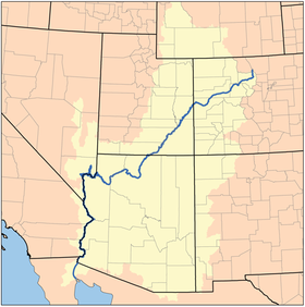
The Colorado River , is a river in the Southwestern United States and northwestern Mexico, approximately long, draining a part of the arid regions on the western slope of the Rocky Mountains. The watershed of the Colorado River covers in parts of seven U.S. states and two Mexican states...
of the southwestern United States
Southwestern United States
The Southwestern United States is a region defined in different ways by different sources. Broad definitions include nearly a quarter of the United States, including Arizona, California, Colorado, Nevada, New Mexico, Oklahoma, Texas and Utah...
in North America
North America
North America is a continent wholly within the Northern Hemisphere and almost wholly within the Western Hemisphere. It is also considered a northern subcontinent of the Americas...
that rises in the Rocky Mountains
Rocky Mountains
The Rocky Mountains are a major mountain range in western North America. The Rocky Mountains stretch more than from the northernmost part of British Columbia, in western Canada, to New Mexico, in the southwestern United States...
and has its outlet at the Colorado River Delta
Colorado River Delta
The Colorado River Delta is the region where the Colorado River flows into the Gulf of California . The delta is part of a larger geologic region called the Salton Trough. Historically, the interaction of the river’s flow and the ocean’s tide created a dynamic environment, supporting freshwater,...
in the northern Sea of Cortez in northwestern Mexico
Mexico
The United Mexican States , commonly known as Mexico , is a federal constitutional republic in North America. It is bordered on the north by the United States; on the south and west by the Pacific Ocean; on the southeast by Guatemala, Belize, and the Caribbean Sea; and on the east by the Gulf of...
, between the states of Baja California
Baja California
Baja California officially Estado Libre y Soberano de Baja California is one of the 31 states which, with the Federal District, comprise the 32 Federal Entities of Mexico. It is both the northernmost and westernmost state of Mexico. Before becoming a state in 1953, the area was known as the North...
and Sonora
Sonora
Sonora officially Estado Libre y Soberano de Sonora is one of the 31 states which, with the Federal District, comprise the 32 Federal Entities of Mexico. It is divided into 72 municipalities; the capital city is Hermosillo....
. This north–south stretch of the Colorado River forms the border between the U.S. state
U.S. state
A U.S. state is any one of the 50 federated states of the United States of America that share sovereignty with the federal government. Because of this shared sovereignty, an American is a citizen both of the federal entity and of his or her state of domicile. Four states use the official title of...
s of California
California
California is a state located on the West Coast of the United States. It is by far the most populous U.S. state, and the third-largest by land area...
and Arizona
Arizona
Arizona ; is a state located in the southwestern region of the United States. It is also part of the western United States and the mountain west. The capital and largest city is Phoenix...
, and Nevada
Nevada
Nevada is a state in the western, mountain west, and southwestern regions of the United States. With an area of and a population of about 2.7 million, it is the 7th-largest and 35th-most populous state. Over two-thirds of Nevada's people live in the Las Vegas metropolitan area, which contains its...
and Arizona; also between the Mexican states of Baja California and Sonora.
It is commonly defined as the region from below Hoover Dam
Hoover Dam
Hoover Dam, once known as Boulder Dam, is a concrete arch-gravity dam in the Black Canyon of the Colorado River, on the border between the US states of Arizona and Nevada. It was constructed between 1931 and 1936 during the Great Depression and was dedicated on September 30, 1935, by President...
and Lake Mead
Lake Mead
Lake Mead is the largest reservoir in the United States. It is located on the Colorado River about southeast of Las Vegas, Nevada, in the states of Nevada and Arizona. Formed by water impounded by the Hoover Dam, it extends behind the dam, holding approximately of water.-History:The lake was...
to its outlet at the northern Gulf of California
Gulf of California
The Gulf of California is a body of water that separates the Baja California Peninsula from the Mexican mainland...
(Sea of Cortez); it includes the Colorado River proper, canyons, the valley, mountain ranges with wilderness areas, and the floodplain and associated riparian environments. It is home to recreation
Recreation
Recreation is an activity of leisure, leisure being discretionary time. The "need to do something for recreation" is an essential element of human biology and psychology. Recreational activities are often done for enjoyment, amusement, or pleasure and are considered to be "fun"...
activities from the river
River
A river is a natural watercourse, usually freshwater, flowing towards an ocean, a lake, a sea, or another river. In a few cases, a river simply flows into the ground or dries up completely before reaching another body of water. Small rivers may also be called by several other names, including...
, the lake
Lake
A lake is a body of relatively still fresh or salt water of considerable size, localized in a basin, that is surrounded by land. Lakes are inland and not part of the ocean and therefore are distinct from lagoons, and are larger and deeper than ponds. Lakes can be contrasted with rivers or streams,...
s created by dam
Dam
A dam is a barrier that impounds water or underground streams. Dams generally serve the primary purpose of retaining water, while other structures such as floodgates or levees are used to manage or prevent water flow into specific land regions. Hydropower and pumped-storage hydroelectricity are...
s, agriculture
Agriculture
Agriculture is the cultivation of animals, plants, fungi and other life forms for food, fiber, and other products used to sustain life. Agriculture was the key implement in the rise of sedentary human civilization, whereby farming of domesticated species created food surpluses that nurtured the...
, and the home of various cities, communities, and towns along the river, or associated with the valley region. Five Indian reservations are located in the LCRV: the Chemehuevi, Fort Mojave
Fort Mojave Indian Reservation
The Fort Mojave Indian Reservation is an Indian reservation along the Colorado River, currently encompassing 23,669 acres in Arizona, 12,633 acres in California, and 5,582 acres in Nevada. The reservation was originally established in 1870 and is now home to approximately 1,100 members of the...
and Colorado River Indian Reservation
Colorado River Indian Reservation
The Colorado River Indian Reservation is 189 miles west of Phoenix, Arizona, on highway 95. It lies in western La Paz County, Arizona, southeastern San Bernardino County, California, and northeastern Riverside County, California. It has a total land area of 432.22 sq mi , and most of it lies...
s; at Yuma are the Quechan
Quechan
The Quechan are a Native American tribe who live on the Fort Yuma Indian Reservation on the lower Colorado River in Arizona and California just north of the border with Mexico...
and Cocopah reservations.
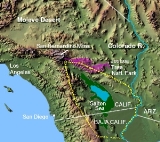
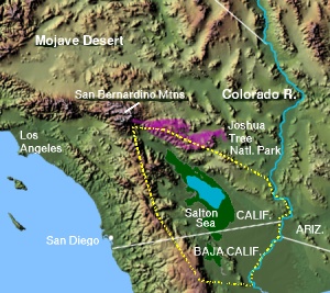
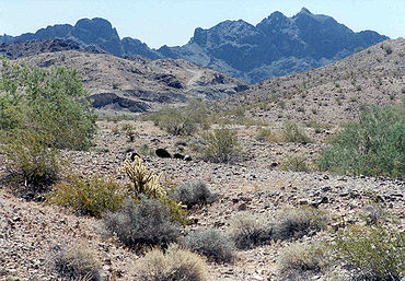
The LCRV, a desert region
Desert
A desert is a landscape or region that receives an extremely low amount of precipitation, less than enough to support growth of most plants. Most deserts have an average annual precipitation of less than...
temperatures-(of North America) are recorded in the LCRV, rivaling Death Valley
Death Valley
Death Valley is a desert valley located in Eastern California. Situated within the Mojave Desert, it features the lowest, driest, and hottest locations in North America. Badwater, a basin located in Death Valley, is the specific location of the lowest elevation in North America at 282 feet below...
; specifically Bullhead City
Bullhead City, Arizona
Bullhead City is a city located on the Colorado River in Mohave County, Arizona, USA, roughly south of Las Vegas, Nevada, and directly across the Colorado River from Laughlin, Nevada, whose casinos and ancillary services supply much of the employment for Bullhead City...
, Laughlin
Laughlin, Nevada
Laughlin is a census-designated place in Clark County, Nevada, United States, and a port located on the Colorado River. Laughlin is south of Las Vegas, located in the far southern tip of Nevada. It is best known for its gaming, entertainment, and water recreation. As of the 2010 census, the...
, Needles
Needles, California
Needles is a city located in the Mojave Desert on the western banks of the Colorado River in San Bernardino County, California. It is located in the Mohave Valley, which straddles the California–Arizona border. The city is accessible via Interstate 40 and U.S. Route 95...
, Yuma
Yuma, Arizona
Yuma is a city in and the county seat of Yuma County, Arizona, United States. It is located in the southwestern corner of the state, and the population of the city was 77,515 at the 2000 census, with a 2008 Census Bureau estimated population of 90,041....
, or the southeast deserts of California, west of the Colorado River. The LCRV is defined by three deserts. The Mojave Desert
Mojave Desert
The Mojave Desert occupies a significant portion of southeastern California and smaller parts of central California, southern Nevada, southwestern Utah and northwestern Arizona, in the United States...
is in southeast California, southern Nevada, and northwest Arizona. To the south is the Sonoran Desert
Sonoran Desert
The Sonoran Desert is a North American desert which straddles part of the United States-Mexico border and covers large parts of the U.S. states of Arizona and California and the northwest Mexican states of Sonora, Baja California, and Baja California Sur. It is one of the largest and hottest...
on both sides of the Colorado River. However an ecozone delineation occurs in the transition from Arizona to southeast California; consequently the western side of the Colorado River is defined as the western Sonoran Desert and given the name Colorado Desert
Colorado Desert
California's Colorado Desert is a part of the larger Sonoran Desert, which extends across southwest North America. The Colorado Desert region encompasses approximately , reaching from the Mexican border in the south to the higher-elevation Mojave Desert in the north and from the Colorado River in...
; the ecozone of this western Sonoran Desert extends south into the northwest region of Sonora, Mexico and the extreme northeast of northern Baja California, Mexico.
Sonoran Desert
The Sonoran Desert is a North American desert which straddles part of the United States-Mexico border and covers large parts of the U.S. states of Arizona and California and the northwest Mexican states of Sonora, Baja California, and Baja California Sur. It is one of the largest and hottest...
; the Sonoran Desert region proper extends from areas west of the river, and then southeastwards to southeast Arizona, south to the tip of Baja California Sur
Baja California Sur
Baja California Sur , is one of the 31 states which, with the Federal District, comprise the 32 Federal Entities of Mexico. Before becoming a state on October 8, 1974, the area was known as the South Territory of Baja California. It has an area of , or 3.57% of the land mass of Mexico and comprises...
, eastwards of the Baja Peninsula cordillera, and south through Sonora
Sonora
Sonora officially Estado Libre y Soberano de Sonora is one of the 31 states which, with the Federal District, comprise the 32 Federal Entities of Mexico. It is divided into 72 municipalities; the capital city is Hermosillo....
state, Mexico to the northern border of neighboring Sinaloa
Sinaloa
Sinaloa officially Estado Libre y Soberano de Sinaloa is one of the 31 states which, with the Federal District, comprise the 32 Federal Entities of Mexico. It is divided in 18 municipalities and its capital city is Culiacán Rosales....
.
The LCRV extends about 350 miles (563 km) from Hoover Dam to the Colorado River Delta
Colorado River Delta
The Colorado River Delta is the region where the Colorado River flows into the Gulf of California . The delta is part of a larger geologic region called the Salton Trough. Historically, the interaction of the river’s flow and the ocean’s tide created a dynamic environment, supporting freshwater,...
. The Sonoran Desert itself is more than twice as extensive north-to-south, and about 450 miles (724 km) in width. Two species, Desert Ironwood-(Olneya tesota
Olneya tesota
Olneya tesota is a perennial flowering tree of the Fabaceae family, legumes , which is commonly known as Ironwood or Desert Ironwood. It is the only species in the monotypic genus Olneya...
) and the Lesser Long-nosed Bat
Lesser Long-nosed Bat
The Lesser Long-nosed Bat is a medium-sized bat found in El Salvador, Guatemala, Honduras, Mexico and the United States...
, have geographic ranges identical to the Sonoran Desert, and are indicator species
Indicator species
An indicator species is any biological species that defines a trait or characteristic of the environment. For example, a species may delineate an ecoregion or indicate an environmental condition such as a disease outbreak, pollution, species competition or climate change...
of the Sonoran Desert region. The spring flowering of Ironwood, and the bat species migration arrivals also become indicators of annual or multi-year climate trends for regions of the Sonoran Desert.
Ecological threats
The Lower Colorado River Valley subregion of the Sonoran Desert bioregion has multiple threats. Some major threats include urbanizationUrbanization
Urbanization, urbanisation or urban drift is the physical growth of urban areas as a result of global change. The United Nations projected that half of the world's population would live in urban areas at the end of 2008....
, clearing of land for agricultre, human occupancy – especially as a result of imported external resources, and camping and camptrailers on BLM land. Other threats include harvesting for fuelwood, campfires, etc of desert ironwood, Olneya tesota
Olneya tesota
Olneya tesota is a perennial flowering tree of the Fabaceae family, legumes , which is commonly known as Ironwood or Desert Ironwood. It is the only species in the monotypic genus Olneya...
, destruction of land by offroad vehicles, especially in sand dunes, and harvesting and manipulation of groundwater.
List of major cities and communities
- LaughlinLaughlin, NevadaLaughlin is a census-designated place in Clark County, Nevada, United States, and a port located on the Colorado River. Laughlin is south of Las Vegas, located in the far southern tip of Nevada. It is best known for its gaming, entertainment, and water recreation. As of the 2010 census, the...
, Nevada in Clark County, NevadaClark County, Nevada-Demographics:As of the census of 2000, there were 1,375,765 people, 512,253 households, and 339,693 families residing within the MSA. The racial makeup of the MSA was 71.6% White , 9.1% Black, 5.7% Asian, 0.8% American Indian and 12.8% of other or mixed race. 22.0% were Hispanic of any race... - NeedlesNeedles, CaliforniaNeedles is a city located in the Mojave Desert on the western banks of the Colorado River in San Bernardino County, California. It is located in the Mohave Valley, which straddles the California–Arizona border. The city is accessible via Interstate 40 and U.S. Route 95...
, California in San Bernardino, CaliforniaSan Bernardino, CaliforniaSan Bernardino is a city located in the Riverside-San Bernardino metropolitan area , and serves as the county seat of San Bernardino County, California, United States... - Bullhead CityBullhead City, ArizonaBullhead City is a city located on the Colorado River in Mohave County, Arizona, USA, roughly south of Las Vegas, Nevada, and directly across the Colorado River from Laughlin, Nevada, whose casinos and ancillary services supply much of the employment for Bullhead City...
, Arizona - Mojave ValleyMohave Valley, ArizonaMohave Valley is a census-designated place in Mohave County, Arizona, United States. The population was 13,694 at the 2000 census. It is geographically connected to Needles, California and Bullhead City, Arizona....
, Arizona - Lake Havasu City, ArizonaLake Havasu City, Arizona-Demographics:As of the census of 2000, there were 41,938 people, 17,911 households, and 12,716 families residing in the city. The population density was 974.4 people per square mile . There were 23,018 housing units at an average density of 534.8 per square mile...
- VidalVidal, CaliforniaVidal, California is a small Unincorporated community located in southeastern California, in San Bernardino County on U.S. Route 95, north of Blythe, California and south of Needles. The town is west of the townsite of Earp, California and west of Parker, Arizona on State Highway 62. The town...
, California - ParkerParker, ArizonaParker is a town in and the county seat of La Paz County, Arizona, United States, on the Colorado River in Parker Valley. The population was 3,140 at the 2000 census.-History:...
, Arizona - BlytheBlythe, CaliforniaBlythe is a city in Riverside County, California, United States, in the "Palo Verde Valley" of the Lower Colorado River Valley region, an agricultural area and part of the Colorado Desert along the Colorado River. Blythe was named after Thomas Blythe, a gold prospector who established primary...
, California - QuartziteQuartzsite, ArizonaQuartzsite is a town in La Paz County, Arizona, United States. According to Census Bureau estimates, the population of the town was 3,397 in 2006.Interstate 10 runs directly through Quartzsite. It is at the intersection of U.S...
, Arizona - WinterhavenWinterhaven, CaliforniaWinterhaven is a census-designated place in Imperial County, California. Winterhaven is located east of Pilot Knob, The population was 394 at the 2010 census, down from 529 at the 2000 census. It is part of the 'El Centro, California Metropolitan Statistical Area'...
, California in Imperial County, CaliforniaImperial County, CaliforniaImperial County is a county located in the Imperial Valley, in the far southeast of the U.S. state of California, bordering both Arizona and Mexico. It is part of the El Centro Metropolitan Area, which encompasses all of Imperial County. The population as of 2000 was 142,361. The county seat is the... - YumaYuma, ArizonaYuma is a city in and the county seat of Yuma County, Arizona, United States. It is located in the southwestern corner of the state, and the population of the city was 77,515 at the 2000 census, with a 2008 Census Bureau estimated population of 90,041....
, Arizona in Yuma County, ArizonaYuma County, Arizona-2010:Whereas according to the 2010 U.S. Census Bureau:*70.4% White*2.0% Black*1.6% Native American*1.2% Asian*0.2% Native Hawaiian or Pacific Islander*3.8% Two or more races*20.8% Other races*59.7% Hispanic or Latino -2000:... - San LuisSan Luis, ArizonaSan Luis is a city in Yuma County, Arizona, United States. The population was 15,322 at the 2000 census. It is part of the Yuma Metropolitan Statistical Area. San Luis was the second fastest-growing place among all cities and towns in Arizona of any size from 1990 and 2000...
, Arizona - San Luis Río ColoradoSan Luis Río ColoradoSan Luis Río Colorado is a city and its surrounding municipality lying in the northwestern corner of the state of Sonora, Mexico.- Location :...
, Sonora
Complete list of towns, areas, etc, north to south
|
|
Feeder-valleys, or included small valleys
|
|
See also
- Rio GrandeRio GrandeThe Rio Grande is a river that flows from southwestern Colorado in the United States to the Gulf of Mexico. Along the way it forms part of the Mexico – United States border. Its length varies as its course changes...
, the eastern river valley drainage of the Southwest USA- Rio Grande ValleyRio Grande ValleyThe Rio Grande Valley or the Lower Rio Grande Valley, informally called The Valley, is an area located in the southernmost tip of South Texas...
- Rio Grande Valley
- :Category:Rio Grande
- :Category:Fauna of the U.S. Rio Grande River Valleys
- List of dams of the LCRV
- List of LCRV communities (birdwatching)
External links
- Journey of the Nectar Bats
- Map, and Lesser Long-nosed Bat range; Article: Signs of Spring
- "Lower Colorado River Valley" section, Center for Sonoran Desert Studies
Ecology
Water Resources, Dams
- (southern, Arizona section), Lower Colorado River basins, planning, (with Basin/Regions map)
- http://www.adwr.state.az.us/azdwr/StatewidePlanning/WaterAtlas/UpperColoradoRiver/PlanningAreaOverview/UpperColoradoSurfaceWaterHydrology.htm(northern, Arizona section), Lower Colorado River basins, (Mohave County, & NW Arizona, Upper Colorado River Planning Area Surface Water Hydrology, w/ an Area Watersheds Map); Sacramento WashSacramento WashThe Sacramento Wash is a major drainage of northwest Arizona in Mohave County. The wash is east of the Black Canyon of the Colorado and drains into the south-flowing Colorado River 45 mi south of Lake Mohave, and 90 mi south of Hoover Dam at Lake Mead. The wash outfall is in the...
, etc.] - US Bureau of Reclamation, "Dams Along the Lower Colorado River"