
Pershing County, Nevada
Overview
Pershing County is a county located in the U.S. state
of Nevada
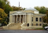
. As of the 2000 census, the population was 6,693. Its county seat
is Lovelock
. The county was named after army general John J. Pershing
(1860–1948). It was formed from Humboldt County
in 1919, and the last county to be established in Nevada.
According to the U.S. Census Bureau
, the county has a total area of 6,068 square miles (15,715 km²), of which 6,037 square miles (15,635 km²) is land and 31 square miles (80 km²) (0.51%) is water.
As of the census
of 2000, there were 6,693 people, 1,962 households, and 1,383 families residing in the county.
U.S. state
A U.S. state is any one of the 50 federated states of the United States of America that share sovereignty with the federal government. Because of this shared sovereignty, an American is a citizen both of the federal entity and of his or her state of domicile. Four states use the official title of...
of Nevada
Nevada
Nevada is a state in the western, mountain west, and southwestern regions of the United States. With an area of and a population of about 2.7 million, it is the 7th-largest and 35th-most populous state. Over two-thirds of Nevada's people live in the Las Vegas metropolitan area, which contains its...
. As of the 2000 census, the population was 6,693. Its county seat
County seat
A county seat is an administrative center, or seat of government, for a county or civil parish. The term is primarily used in the United States....
is Lovelock
Lovelock, Nevada
Lovelock is a city in western Nevada that is the county seat of Pershing County, the location of a prison, and the namesake of the area's Cold War gunnery range...
. The county was named after army general John J. Pershing
John J. Pershing
John Joseph "Black Jack" Pershing, GCB , was a general officer in the United States Army who led the American Expeditionary Forces in World War I...
(1860–1948). It was formed from Humboldt County
Humboldt County, Nevada
Humboldt County is a county located in the U.S. state of Nevada. As of 2007, the population was estimated to be 18,052. Its county seat is Winnemucca.The county was the site of an arrest in 2000 that led to the U.S. Supreme Court decision Hiibel v...
in 1919, and the last county to be established in Nevada.
According to the U.S. Census Bureau
United States Census Bureau
The United States Census Bureau is the government agency that is responsible for the United States Census. It also gathers other national demographic and economic data...
, the county has a total area of 6,068 square miles (15,715 km²), of which 6,037 square miles (15,635 km²) is land and 31 square miles (80 km²) (0.51%) is water.
- ImlayImlay, NevadaImlay is a small town in Pershing County, Nevada. It has an elementary school, a general store, a post office, and a trading post.As of 2005, the population of Imlay, Nevada, was 233....
- LovelockLovelock, NevadaLovelock is a city in western Nevada that is the county seat of Pershing County, the location of a prison, and the namesake of the area's Cold War gunnery range...
- Mill CityMill City, NevadaMill City is an unincorporated community in Pershing County, Nevada, United States. The ZIP Code of Mill City is 89418.Mill City was established to process the ore from nearby mines at a location with water from the Humboldt River and railroad access...
- UnionvilleUnionville, NevadaUnionville is a small hamlet in Pershing County, Nevada, with the most recent population estimate being approximately 20 people. The town's best years were during the 1870s, when it was an active mining and prospecting town serving the surrounding hilly region. For a brief time, Samuel Langhorne...
- Washoe County, NevadaWashoe County, NevadaWashoe County is a county located in the U.S. state of Nevada. The population was 421,407 at the 2010 census. Its county seat is Reno. Washoe County includes the Reno-Sparks metropolitan area.-History:...
- west - Humboldt County, NevadaHumboldt County, NevadaHumboldt County is a county located in the U.S. state of Nevada. As of 2007, the population was estimated to be 18,052. Its county seat is Winnemucca.The county was the site of an arrest in 2000 that led to the U.S. Supreme Court decision Hiibel v...
- north - Lander County, NevadaLander County, NevadaLander County is a county located in the U.S. state of Nevada. As of the 2000 census, the population was 5,794. Its county seat is Battle Mountain.-History:...
- east - Churchill County, NevadaChurchill County, NevadaChurchill County is a county located in the western U.S. state of Nevada. As of the 2000 census, the population was 23,982. As of July 1, 2007, the population of Churchill County was estimated at 27,190. The county, named after Mexican-American War hero brevet Brigadier General Sylvester Churchill,...
- south
- Black Rock Desert-High Rock Canyon Emigrant Trails National Conservation AreaBlack Rock Desert-High Rock Canyon Emigrant Trails National Conservation AreaThe Black Rock Desert – High Rock Canyon Emigrant Trails National Conservation Area is the federal land in northwestern Nevada, under the Bureau of Land Management-BLM management and protection, and the ten Wilderness Areas within it....
(part)
As of the census
Census
A census is the procedure of systematically acquiring and recording information about the members of a given population. It is a regularly occurring and official count of a particular population. The term is used mostly in connection with national population and housing censuses; other common...
of 2000, there were 6,693 people, 1,962 households, and 1,383 families residing in the county.
Unanswered Questions