
South San Francisco, California
Encyclopedia
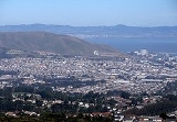
South San Francisco is a city in San Mateo County
, California
, United States
, located on the San Francisco Peninsula
in the San Francisco Bay Area
. The population was 63,632 at the 2010 census.
South San Francisco lies north of San Bruno and San Francisco International Airport
in a small valley south of Daly City, Colma
, Brisbane
, and San Bruno Mountain
, east of Pacifica
and the hills of the Coast Range
, and west of the waters of San Francisco Bay
. Most of the valley faces San Francisco Bay, affording bay views from higher levels.
South San Francisco has mild winters and dry cool summers. The hills to the west shield the city from much of the fog that prevails in neighboring areas.
Population has tripled since World War II with the opening of such subdivisions as Buri Buri, Winston Manor and Westborough on the slopes west of El Camino. It has grown from 4,411 in 1920 to 61,824 in 2006.
Sign Hill, which rises to the north of the city bears large white letters that proclaim: "South San Francisco, The Industrial City," which refers mainly to the flat land east of the Bayshore Freeway (US 101). Locals often refer to the town as "South City," in much the same way that San Francisco is called "The City." People unfamiliar with the area often mistake "South San Francisco" as the southern part of the city of San Francisco. In fact, the city of South San Francisco is not even contiguous with the city of San Francisco, due to the city of Brisbane
being between it and San Francisco itself.
(SFO). A BART station, located directly adjacent to El Camino High School
and Solaire Transit Village, provides rapid transit
service to SFO, the city of San Francisco, and the East Bay
. BART supplements the older Caltrain
service to San Francisco and San Jose. Caltrain's station is adjacent to downtown on Grand Ave.
The city is served by two major north-south freeways, U.S. Route 101 (the Bayshore Freeway), along the San Francisco Bay, and Interstate 280
, along the hills of the Santa Cruz Mountains
.
 South San Francisco is part of the South San Francisco Unified School District
, which also serves portions of the neighboring cities of Daly City
and San Bruno
. The city is home to two public high schools: El Camino High School
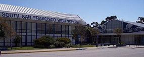
and South San Francisco High School
, which share a cross-town rivalry. The city also has three public middle schools: Parkway Heights
, Westborough
, and Alta Loma. These public high and middle schools, as well as a number of public elementary schools, and an adult school, South San Francisco Adult Education, are part of the South San Francisco Unified School District
.
Several parochial school
s are also established in the city: All Souls School, Mater Dolorosa School
(recently closed), and St. Veronica's School
.
The city is served by the Peninsula Library System
.
, are located west of Highway 101, while the area east of Highway 101 is dominated by industrial complexes interspersed with modern office parks, particularly near the Oyster Point Marina on San Francisco Bay. The extreme western portions of the city near Interstate 280
sit along a hillside and offer views of San Francisco Bay
. This area is known to local residents as Westborough. The southern part of the city, closest to the airport, is home to a large number of car repair shops, airport parking lots, and airport hotels.
Grand Avenue, from Chestnut to Airport, is considered downtown South San Francisco, with various small shops and restaurants. Grand Avenue is host to a plethora of stores, one of which is Bronstein Music, a well-known local music store that has been around for decades. City Hall is located on Grand Avenue, which, to the residents of South City, is known simply as "Grand." Grand also runs perpendicular with one of the city's other well-known streets, Linden, which connects San Bruno to Highway 101. Chestnut Avenue connects Hillside, the northern bordering street at the foot of San Bruno Mountain, to Westborough Blvd, and subsequently to one of the neighborhoods known as Westborough.
South San Francisco Consists of the following Neighborhoods:
Paradise Valley is so named because it resides in between Sign Hill and San Bruno Mountain.
Students mostly from Westborough and Buri Buri attend El Camino High School
. The majority of Brentwood and Paradise Valley inhabitants attend South San Francisco High School
, as well as the East Side inhabitants. The same inhabitants are also so-divided among Westborough Middle School
, Alta Loma Middle School and Parkway Heights Middle School
respectively.
or travels through the nearby San Francisco International Airport
. Sign Hill, near San Bruno Mountain State Park has huge letters on its mountainside http://maps.google.com/maps?ll=37.663406,-122.418026&spn=0.004284,0.007094&t=k&hl=en which read: "SOUTH SAN FRANCISCO THE INDUSTRIAL CITY." The letters are made of concrete and sit flush with the hillside (in contrast to the raised steel letters of the Hollywood Sign
in Los Angeles
). A discontinued tradition involved painting the "c"s on the sign blue and the "s"s red in significance of the annual "Big Game" played by Stanford University
and the University of California, Berkeley
. However, a new tradition has replaced it. Every year South San Francisco High School
plays their rival El Camino High School (South San Francisco)
(both schools are located in South San Francisco) in the "Bell Game," the last football game of the regular season for both teams. It is said that students from South City paint the "SC" in blue before the start of the Bell Game and students from El Camino paint the "EC" red. The "SF" from South and Francisco were painted orange after the San Francisco Giants
won the 2010 World Series
. On the top of Sign Hill, a tall pole with electric lights serves as an electric Christmas tree
, which is typically lit from the day after Thanksgiving
until January 6. The "tree" is visible for many miles at night. In 2008, that same electric pole was modified to hold a vertical number 100 to celebrate South San Francisco's 100th year as an incorporated city.
South San Francisco has a number of parks, the largest of which is Orange Memorial Park. This park has softball fields, soccer fields, picnic grounds, play areas, tennis courts, basketball courts, bocce ball, an indoor swimming pool, and a newly created skate park. It also hosts a farmers market during the summer months and the annual South San Francisco "Day in the Park" in September. The South San Francisco Public Library
has served the city since 1917. The city also has a marina along the shore of San Francisco Bay
, named Oyster Point.
A unique opportunity was created when BART expanded down the Peninsula to create a "linear park" on the swath of unimproved land on top of the tube. Running from Colma to Millbrae, South San Francisco's portion is three miles long, running through the center of town from the South San Francisco BART Station to the San Bruno BART Station. The Class I bicycle and pedestrian trail is a 10" wide asphalt pathway with 2' decomposed granite shoulders, irrigated for low maintenance landscaping, with safety lighting, signalized intersections where the trail crosses Spruce and Chestnut Avenues, and in-ground flashing lights at Orange Avenue. Also, a dog park is located adjacent from Orange Park along the pathway. The new park is called Centennial Way to commemorate the City's 100 year birthday in 2008.
The South San Francisco Farmers Market is at Orange Memorial Park from May through October, 9am to 1pm. The market offers only California-grown products sold directly to consumers by the farmers that grew, nurtured and harvested the crops
Every Holiday season, the Parkway Estates, a group of high-income houses built decades ago, decorate their houses with Christmas lights and Yard decorations. This display is always open to the public and sees hundreds of visitors every holiday season. It is one of the well known holiday attractions during the season. A smaller, littler-known area that does this too is Lilac Lane, which does not draw as much attention.
Bertolucci's is the name of a local Italian Restaurant that has also been around almost since the birth of the city. It is a widely, internationally known restaurant that thrived during the 60s/70s. It is located in close proximity to downtown South San Francisco and is easily seen from highway 101.
South San Francisco has one bowling alley known as Brentwood Bowl due to its proximity to the Brentwood Neighborhood on El Camino Real
. The city is also home to the private California Golf & Country Club, next to its public library and bounded by Ponderosa Road.
South San Francisco has many walkways and bike trails that run adjacent to the San Francisco Bay
, from where runners are able to view San Francisco International Airport
operations. South San Francisco is home to many hotels as well, since it is the closest city to San Francisco that is actually directly next to SFO.
, but these lands are disappearing quickly because of the demand for housing and retail development. Acres of Orchids, founded by the Rod McLellan Company in the late 1920s, was one such victim of housing development. Once one of the largest facilities in the United States producing orchids and gardenia
s, the nursery closed in 1998. A new housing tract now sits upon the land formerly occupied by Acres of Orchids greenhouses, off El Camino near Hickey.
The flat land east of Bayshore Freeway (US 101) is the R&D Campus of South San Francisco and carries on the tradition of the moniker on Sign Hill, "The Industrial City." South San Francisco's office parks and industrial zoning are favorable to meet needs of industry, and the property taxes levied from the extensive industrial park provide revenues for the city. South San Francisco is home to 1 Fortune 500
company, food wholesaler Core-Mark.
South San Francisco is home to Genentech
, one of the world's largest biotech companies, as well as a satellite office of Amgen
, the world's largest biotech firm. Many other biotech companies, such as Exelixis
, have also started or moved to South San Francisco to be in proximity to the UCSF
, Stanford University
, and UC Berkeley
; all are within a one hour's drive. A Genentech-sponsored sign declares South San Francisco as the "Birthplace of Biotechnology."
The headquarters and factory of See's Candies
is located in South San Francisco. Air China
operates an office in South San Francisco.
Galoob
had its headquarters in South San Francisco before Hasbro
bought the company in 1998. Hudson Soft USA, a subsidiary of Hudson Soft
, had its headquarters in South San Francisco.
According to the United States Census Bureau
, the city has a total area of 30.2 square miles (78.2 km²), of which, 9.1 square miles (23.6 km²) of it is land and 21 square miles (54.4 km²) of it (69.69%) is water.
was 2,109.9 people per square mile (814.7/km²). The racial makeup of South San Francisco was 23,760 (37.3%) White, 1,625 (2.6%) African American, 395 (0.6%) Native American, 23,293 (36.6%) Asian, 1,111 (1.7%) Pacific Islander, 9,598 (15.1%) from other races
, and 3,850 (6.1%) from two or more races. Hispanic or Latino of any race were 21,645 persons (34.0%). Among the Hispanic population, 13,194 (20.7%) are Mexican
, 571 (0.9%) are Puerto Rican
, 92 (0.1%) are Cuban
, and 7,788 (12.2%) are other Hispanic or Latino.
The Census reported that 63,053 people (99.1% of the population) lived in households, 528 (0.8%) lived in non-institutionalized group quarters, and 51 (0.1%) were institutionalized.
There were 20,938 households, out of which 7,588 (36.2%) had children under the age of 18 living in them, 11,165 (53.3%) were opposite-sex married couples
living together, 2,897 (13.8%) had a female householder with no husband present, 1,268 (6.1%) had a male householder with no wife present. There were 1,083 (5.2%) unmarried opposite-sex partnerships
, and 187 (0.9%) same-sex married couples or partnerships. 4,299 households (20.5%) were made up of individuals and 1,857 (8.9%) had someone living alone who was 65 years of age or older. The average household size was 3.01. There were 15,330 families
(73.2% of all households); the average family size was 3.45.
The population was spread out with 13,787 people (21.7%) under the age of 18, 5,668 people (8.9%) aged 18 to 24, 18,645 people (29.3%) aged 25 to 44, 17,203 people (27.0%) aged 45 to 64, and 8,329 people (13.1%) who were 65 years of age or older. The median age was 38.1 years. For every 100 females there were 97.6 males. For every 100 females age 18 and over, there were 95.7 males.
There were 21,814 housing units at an average density of 723.3 per square mile (279.3/km²), of which 12,614 (60.2%) were owner-occupied, and 8,324 (39.8%) were occupied by renters. The homeowner vacancy rate was 1.3%; the rental vacancy rate was 4.0%. 37,802 people (59.4% of the population) lived in owner-occupied housing units and 25,251 people (39.7%) lived in rental housing units.
of 2008, there were 62,502 people, 20,118 households, and 15,431 families residing in the city. The population density
was 7,712.8 people per square mile (3,591.9/km²). There were 20,870 housing units at an average density of 3,232.5 per square mile (962.0/km²).
There were 20,118 households out of which 39.2% had children under the age of 18 living with them, 51.8% were married couples
living together, 11.2% had a female householder with no husband present, and 28.5% were non-families. 21.9% of all households were made up of individuals and 8.0% had someone living alone who was 65 years of age or older. The average household size was 4.05 and the average family size was 4.51.
In the city the population was spread out with 25.2% under the age of 18, 11.2% from 18 to 24, 33.0% from 25 to 44, 22.0% from 45 to 64, and 11.6% who were 65 years of age or older. The median age was 33 years. For every 100 females there were 99.3 males. For every 100 females age 18 and over, there were 91.5 males.
The median income
for a household in the city was $60,764, and the median income for a family was $65,598. Males had a median income of $41,742 versus $35,453 for females. The per capita income
for the city was $25,562. About 5.5% of families and 6.2% of the population were below the poverty line, including 9.1% of those under age 18 and 5.7% of those age 65 or over.
South San Francisco is a middle class
and working class
city. However, that image is quickly changing as many luxury homes have been built, particularly at the foot of the mountain that divides Brisbane
and South San Francisco, in the area in recent years to take advantage of the city's close proximity to downtown San Francisco, the bio-tech industry, and the peninsula. There are also developments of luxury condominiums in the Westborough district and on El Camino Real near the South San Francisco BART station.
The most commonly spoken language at home was English 43.13%, followed by Spanish 28.36%, Tagalog 11.48%, Chinese 3.4%, Hindi 1.5%, Arabic 1.59%, Cantonese 1.53%, Italian 1.47%, Vietnamese 0.67%, Russian 0.56%, Korean and Japanese 0.6% respectively, other languages were spoken by less than half of one percent of the population.
South San Francisco is located in the 8th Senate
District, represented by Democrat
Leland Yee
, and in the 19th Assembly
District, represented by Democrat Jerry Hill
. Federally, South San Francisco is located in California's 12th congressional district
, which has a Cook PVI
of D +22 and is currently held by Democrat Jackie Speier
.
, Mexico
Kishiwada, Japan
Lucca
, Italy
Pasig City
, Philippines
San Mateo County, California
San Mateo County is a county located in the San Francisco Bay Area of the U.S. state of California. It covers most of the San Francisco Peninsula just south of San Francisco, and north of Santa Clara County. San Francisco International Airport is located at the northern end of the county, and...
, California
California
California is a state located on the West Coast of the United States. It is by far the most populous U.S. state, and the third-largest by land area...
, United States
United States
The United States of America is a federal constitutional republic comprising fifty states and a federal district...
, located on the San Francisco Peninsula
San Francisco Peninsula
The San Francisco Peninsula is a peninsula in the San Francisco Bay Area that separates the San Francisco Bay from the Pacific Ocean. On its northern tip is the City and County of San Francisco. Its southern base is in Santa Clara County, including the cities of Palo Alto, Los Altos, and Mountain...
in the San Francisco Bay Area
San Francisco Bay Area
The San Francisco Bay Area, commonly known as the Bay Area, is a populated region that surrounds the San Francisco and San Pablo estuaries in Northern California. The region encompasses metropolitan areas of San Francisco, Oakland, and San Jose, along with smaller urban and rural areas...
. The population was 63,632 at the 2010 census.
South San Francisco lies north of San Bruno and San Francisco International Airport
San Francisco International Airport
San Francisco International Airport is a major international airport located south of downtown San Francisco, California, United States, near the cities of Millbrae and San Bruno in unincorporated San Mateo County. It is often referred to as SFO...
in a small valley south of Daly City, Colma
Colma, California
Colma is a small incorporated town in San Mateo County, California, at the northern end of the San Francisco Peninsula in the San Francisco Bay Area. The population was 1,792 at the 2010 census. The town was founded as a necropolis in 1924....
, Brisbane
Brisbane, California
Brisbane is a small city located in the northern part of San Mateo County, California on the lower slopes of San Bruno Mountain. It is on the northeastern edge of South San Francisco, next to the San Francisco Bay and near the San Francisco International Airport.The population was 4,282 as of...
, and San Bruno Mountain
San Bruno Mountain
San Bruno Mountain in northern San Mateo County, California is the northernmost part of the Santa Cruz Mountains. Most of the mountain lies within the San Bruno Mountain State Park, a unique open-space island in the midst of the San Francisco Peninsula's urbanization. Next to the state park is the...
, east of Pacifica
Pacifica, California
Pacifica is a city in San Mateo County, California, on the coast of the Pacific Ocean between San Francisco and Half Moon Bay.-Overview:The City of Pacifica is spread along a six mile stretch of the north central California coastal beach and hills, nestled in several small valleys spanning between...
and the hills of the Coast Range
Santa Cruz Mountains
The Santa Cruz Mountains, part of the Pacific Coast Ranges, are a mountain range in central California, United States. They form a ridge along the San Francisco Peninsula, south of San Francisco, separating the Pacific Ocean from San Francisco Bay and the Santa Clara Valley, and continuing south,...
, and west of the waters of San Francisco Bay
San Francisco Bay
San Francisco Bay is a shallow, productive estuary through which water draining from approximately forty percent of California, flowing in the Sacramento and San Joaquin rivers from the Sierra Nevada mountains, enters the Pacific Ocean...
. Most of the valley faces San Francisco Bay, affording bay views from higher levels.
South San Francisco has mild winters and dry cool summers. The hills to the west shield the city from much of the fog that prevails in neighboring areas.
Population has tripled since World War II with the opening of such subdivisions as Buri Buri, Winston Manor and Westborough on the slopes west of El Camino. It has grown from 4,411 in 1920 to 61,824 in 2006.
Sign Hill, which rises to the north of the city bears large white letters that proclaim: "South San Francisco, The Industrial City," which refers mainly to the flat land east of the Bayshore Freeway (US 101). Locals often refer to the town as "South City," in much the same way that San Francisco is called "The City." People unfamiliar with the area often mistake "South San Francisco" as the southern part of the city of San Francisco. In fact, the city of South San Francisco is not even contiguous with the city of San Francisco, due to the city of Brisbane
Brisbane, California
Brisbane is a small city located in the northern part of San Mateo County, California on the lower slopes of San Bruno Mountain. It is on the northeastern edge of South San Francisco, next to the San Francisco Bay and near the San Francisco International Airport.The population was 4,282 as of...
being between it and San Francisco itself.
Transportation
South San Francisco is adjacent to the San Francisco International AirportSan Francisco International Airport
San Francisco International Airport is a major international airport located south of downtown San Francisco, California, United States, near the cities of Millbrae and San Bruno in unincorporated San Mateo County. It is often referred to as SFO...
(SFO). A BART station, located directly adjacent to El Camino High School
El Camino High School (South San Francisco)
El Camino High School is a four-year American public high school located in South San Francisco, California, directly adjacent to the South San Francisco BART Station...
and Solaire Transit Village, provides rapid transit
Rapid transit
A rapid transit, underground, subway, elevated railway, metro or metropolitan railway system is an electric passenger railway in an urban area with a high capacity and frequency, and grade separation from other traffic. Rapid transit systems are typically located either in underground tunnels or on...
service to SFO, the city of San Francisco, and the East Bay
East Bay (San Francisco Bay Area)
The East Bay is a commonly used, informal term for the lands on the eastern side of the San Francisco Bay, in the San Francisco Bay Area, in California, United States...
. BART supplements the older Caltrain
Caltrain
Caltrain is a California commuter rail line on the San Francisco Peninsula and in the Santa Clara Valley in the United States. The northern terminus of the rail line is in San Francisco, at 4th and King streets; its southern terminus is in Gilroy...
service to San Francisco and San Jose. Caltrain's station is adjacent to downtown on Grand Ave.
The city is served by two major north-south freeways, U.S. Route 101 (the Bayshore Freeway), along the San Francisco Bay, and Interstate 280
Interstate 280 (California)
Interstate 280 is a 57-mile long north–south Interstate Highway in the San Francisco Bay Area of Northern California. It connects San Jose and San Francisco, running along just to the west of the cities of San Francisco Peninsula for most of its route.I-280 from its northern end at King...
, along the hills of the Santa Cruz Mountains
Santa Cruz Mountains
The Santa Cruz Mountains, part of the Pacific Coast Ranges, are a mountain range in central California, United States. They form a ridge along the San Francisco Peninsula, south of San Francisco, separating the Pacific Ocean from San Francisco Bay and the Santa Clara Valley, and continuing south,...
.
Education
South San Francisco Unified School District
The South San Francisco Unified School District is a school district in northern San Mateo County, California, serving the cities of South San Francisco, a small portion of San Bruno, and the Serramonte district of Daly City.- Schools :...
, which also serves portions of the neighboring cities of Daly City
Daly City, California
Daly City is the largest city in San Mateo County, California, United States, with a 2010 population of 101,123. Located immediately south of San Francisco, it is named in honor of businessman and landowner John Daly.-History:...
and San Bruno
San Bruno, California
San Bruno is a city in San Mateo County, California, United States. The population was 41,114 at the 2010 census.The city is adjacent to San Francisco International Airport and Golden Gate National Cemetery.-Geography:San Bruno is located at...
. The city is home to two public high schools: El Camino High School
El Camino High School (South San Francisco)
El Camino High School is a four-year American public high school located in South San Francisco, California, directly adjacent to the South San Francisco BART Station...
and South San Francisco High School
South San Francisco High School
South San Francisco High School, known colloquially as "South City High", is an American public high school located in South San Francisco, California which serves grades 9-12 as part of the South San Francisco Unified School District .-Campus:...
, which share a cross-town rivalry. The city also has three public middle schools: Parkway Heights
Parkway Heights Middle School (South San Francisco)
Parkway Heights Middle School, previously known as Parkway Junior High School, is a school in South San Francisco, California. When the school became a middle school, the word "Heights" was added to the name of the school to avoid the initialism PMS. The school is part of the South San Francisco...
, Westborough
Westborough Middle School (South San Francisco)
Westborough Middle School, previously known as Westborough Junior High School, is a school in South San Francisco, California. It is part of the South San Francisco Unified School District.-External links:*...
, and Alta Loma. These public high and middle schools, as well as a number of public elementary schools, and an adult school, South San Francisco Adult Education, are part of the South San Francisco Unified School District
South San Francisco Unified School District
The South San Francisco Unified School District is a school district in northern San Mateo County, California, serving the cities of South San Francisco, a small portion of San Bruno, and the Serramonte district of Daly City.- Schools :...
.
Several parochial school
Parochial school
A parochial school is a school that provides religious education in addition to conventional education. In a narrower sense, a parochial school is a Christian grammar school or high school which is part of, and run by, a parish.-United Kingdom:...
s are also established in the city: All Souls School, Mater Dolorosa School
Mater Dolorosa Catholic School (South San Francisco)
Mater Dolorosa Catholic School is a closed parochial school in South San Francisco.-External links:*A diverse array of people attend this church, rich, poor, black, white, Asian, and etc.It is in South San Francisco, CA at 307 Willow Avenue....
(recently closed), and St. Veronica's School
Saint Veronica Catholic School
Saint Veronica Catholic School is a private parochial school located in South San Francisco, California. The school enrollment is 340 students spanning the grade levels K through 8...
.
The city is served by the Peninsula Library System
Peninsula Library System
The Peninsula Library System is the public library organization serving San Mateo County, California, United States, which forms the bulk of the region within the San Francisco Bay Area known as "The Peninsula"...
.
Fire stations
South San Francisco currently has five fire stations. Station 61 is home to Engine 61, Rescue 61, Battalion 17,and a BLS ambulance. Station 62 is home to Quint 62 and was home to a reserve quint but was, because of old age, it was donated to Atotonilco,Mexico, a sister city. Station 63 is home to Engine and Rescue 63. It's nickname is "The Bunker". Station 64 is home to Engine 64 as well as a reserve ambulance. Station 65 is home to E65 and USAR 165. Quint 65 used to be based here. Rescue Boat 62 is located at Oyster Point Marina and can be staffed by Q62 personnel if needed.Neighborhoods
The city's small downtown and several aging residential subdivisions, such as Mayfair Village, Sunshine Gardens, Avalon Park, Winston Manor, and Rancho Buri BuriRancho Buri Buri
Rancho Buri Buri was a Mexican land grant in present day San Mateo County, California given in 1835 by Governor José Castro to José Antonio Sánchez. The name derives from the Urebure village of the Ramaytush speaking Yelamu tribe of Ohlone people who were settled by the banks of San Bruno Creek...
, are located west of Highway 101, while the area east of Highway 101 is dominated by industrial complexes interspersed with modern office parks, particularly near the Oyster Point Marina on San Francisco Bay. The extreme western portions of the city near Interstate 280
Interstate 280 (California)
Interstate 280 is a 57-mile long north–south Interstate Highway in the San Francisco Bay Area of Northern California. It connects San Jose and San Francisco, running along just to the west of the cities of San Francisco Peninsula for most of its route.I-280 from its northern end at King...
sit along a hillside and offer views of San Francisco Bay
San Francisco Bay
San Francisco Bay is a shallow, productive estuary through which water draining from approximately forty percent of California, flowing in the Sacramento and San Joaquin rivers from the Sierra Nevada mountains, enters the Pacific Ocean...
. This area is known to local residents as Westborough. The southern part of the city, closest to the airport, is home to a large number of car repair shops, airport parking lots, and airport hotels.
Grand Avenue, from Chestnut to Airport, is considered downtown South San Francisco, with various small shops and restaurants. Grand Avenue is host to a plethora of stores, one of which is Bronstein Music, a well-known local music store that has been around for decades. City Hall is located on Grand Avenue, which, to the residents of South City, is known simply as "Grand." Grand also runs perpendicular with one of the city's other well-known streets, Linden, which connects San Bruno to Highway 101. Chestnut Avenue connects Hillside, the northern bordering street at the foot of San Bruno Mountain, to Westborough Blvd, and subsequently to one of the neighborhoods known as Westborough.
South San Francisco Consists of the following Neighborhoods:
- Avalon Park
- Avalon Pines
- Brentwood
- Buri Buri
- Cypress
- Francisco Terrace
- Mayfair Village
- Paradise Valley
- Parkhaven
- Parkway
- Pecks Lot
- Peninsula Pines
- Serra Highlands
- Southwood
- Sunshine Gardens
- Susie Way
- The East Side
- West Winston Manor
- Westborough
- West Park
- Winston Manor
Paradise Valley is so named because it resides in between Sign Hill and San Bruno Mountain.
Students mostly from Westborough and Buri Buri attend El Camino High School
El Camino High School (South San Francisco)
El Camino High School is a four-year American public high school located in South San Francisco, California, directly adjacent to the South San Francisco BART Station...
. The majority of Brentwood and Paradise Valley inhabitants attend South San Francisco High School
South San Francisco High School
South San Francisco High School, known colloquially as "South City High", is an American public high school located in South San Francisco, California which serves grades 9-12 as part of the South San Francisco Unified School District .-Campus:...
, as well as the East Side inhabitants. The same inhabitants are also so-divided among Westborough Middle School
Westborough Middle School (South San Francisco)
Westborough Middle School, previously known as Westborough Junior High School, is a school in South San Francisco, California. It is part of the South San Francisco Unified School District.-External links:*...
, Alta Loma Middle School and Parkway Heights Middle School
Parkway Heights Middle School (South San Francisco)
Parkway Heights Middle School, previously known as Parkway Junior High School, is a school in South San Francisco, California. When the school became a middle school, the word "Heights" was added to the name of the school to avoid the initialism PMS. The school is part of the South San Francisco...
respectively.
Points of interest and recreation
South San Francisco is not known as a tourist destination, but a key landmark of the city is visible to anyone who travels along the San Francisco PeninsulaSan Francisco Peninsula
The San Francisco Peninsula is a peninsula in the San Francisco Bay Area that separates the San Francisco Bay from the Pacific Ocean. On its northern tip is the City and County of San Francisco. Its southern base is in Santa Clara County, including the cities of Palo Alto, Los Altos, and Mountain...
or travels through the nearby San Francisco International Airport
San Francisco International Airport
San Francisco International Airport is a major international airport located south of downtown San Francisco, California, United States, near the cities of Millbrae and San Bruno in unincorporated San Mateo County. It is often referred to as SFO...
. Sign Hill, near San Bruno Mountain State Park has huge letters on its mountainside http://maps.google.com/maps?ll=37.663406,-122.418026&spn=0.004284,0.007094&t=k&hl=en which read: "SOUTH SAN FRANCISCO THE INDUSTRIAL CITY." The letters are made of concrete and sit flush with the hillside (in contrast to the raised steel letters of the Hollywood Sign
Hollywood Sign
The Hollywood Sign is a landmark and American cultural icon in the Hollywood Hills area of Mount Lee, Santa Monica Mountains, in Los Angeles, California. The sign spells out the name of the area in and white letters. It was created as an advertisement in 1923, but garnered increasing recognition...
in Los Angeles
Los Ángeles
Los Ángeles is the capital of the province of Biobío, in the commune of the same name, in Region VIII , in the center-south of Chile. It is located between the Laja and Biobío rivers. The population is 123,445 inhabitants...
). A discontinued tradition involved painting the "c"s on the sign blue and the "s"s red in significance of the annual "Big Game" played by Stanford University
Stanford University
The Leland Stanford Junior University, commonly referred to as Stanford University or Stanford, is a private research university on an campus located near Palo Alto, California. It is situated in the northwestern Santa Clara Valley on the San Francisco Peninsula, approximately northwest of San...
and the University of California, Berkeley
University of California, Berkeley
The University of California, Berkeley , is a teaching and research university established in 1868 and located in Berkeley, California, USA...
. However, a new tradition has replaced it. Every year South San Francisco High School
South San Francisco High School
South San Francisco High School, known colloquially as "South City High", is an American public high school located in South San Francisco, California which serves grades 9-12 as part of the South San Francisco Unified School District .-Campus:...
plays their rival El Camino High School (South San Francisco)
El Camino High School (South San Francisco)
El Camino High School is a four-year American public high school located in South San Francisco, California, directly adjacent to the South San Francisco BART Station...
(both schools are located in South San Francisco) in the "Bell Game," the last football game of the regular season for both teams. It is said that students from South City paint the "SC" in blue before the start of the Bell Game and students from El Camino paint the "EC" red. The "SF" from South and Francisco were painted orange after the San Francisco Giants
San Francisco Giants
The San Francisco Giants are a Major League Baseball team based in San Francisco, California, playing in the National League West Division....
won the 2010 World Series
2010 World Series
The 2010 World Series was the 106th occurrence of Major League Baseball's championship series. The best-of-seven playoff, played between the American League champion Texas Rangers and the National League champion San Francisco Giants, began on Wednesday, , and ended on Monday, , with the Giants...
. On the top of Sign Hill, a tall pole with electric lights serves as an electric Christmas tree
Christmas tree
The Christmas tree is a decorated evergreen coniferous tree, real or artificial, and a tradition associated with the celebration of Christmas. The tradition of decorating an evergreen tree at Christmas started in Livonia and Germany in the 16th century...
, which is typically lit from the day after Thanksgiving
Thanksgiving (United States)
Thanksgiving, or Thanksgiving Day, is a holiday celebrated in the United States on the fourth Thursday in November. It has officially been an annual tradition since 1863, when, during the Civil War, President Abraham Lincoln proclaimed a national day of thanksgiving to be celebrated on Thursday,...
until January 6. The "tree" is visible for many miles at night. In 2008, that same electric pole was modified to hold a vertical number 100 to celebrate South San Francisco's 100th year as an incorporated city.
South San Francisco has a number of parks, the largest of which is Orange Memorial Park. This park has softball fields, soccer fields, picnic grounds, play areas, tennis courts, basketball courts, bocce ball, an indoor swimming pool, and a newly created skate park. It also hosts a farmers market during the summer months and the annual South San Francisco "Day in the Park" in September. The South San Francisco Public Library
South San Francisco Public Library
The South San Francisco Public Library is located in South San Francisco, California. It is an independent city library and part of the Peninsula Library System, a consortium of city, county, and community college libraries in San Mateo County. The library holds approximately 166,000 volumes and...
has served the city since 1917. The city also has a marina along the shore of San Francisco Bay
San Francisco Bay
San Francisco Bay is a shallow, productive estuary through which water draining from approximately forty percent of California, flowing in the Sacramento and San Joaquin rivers from the Sierra Nevada mountains, enters the Pacific Ocean...
, named Oyster Point.
A unique opportunity was created when BART expanded down the Peninsula to create a "linear park" on the swath of unimproved land on top of the tube. Running from Colma to Millbrae, South San Francisco's portion is three miles long, running through the center of town from the South San Francisco BART Station to the San Bruno BART Station. The Class I bicycle and pedestrian trail is a 10" wide asphalt pathway with 2' decomposed granite shoulders, irrigated for low maintenance landscaping, with safety lighting, signalized intersections where the trail crosses Spruce and Chestnut Avenues, and in-ground flashing lights at Orange Avenue. Also, a dog park is located adjacent from Orange Park along the pathway. The new park is called Centennial Way to commemorate the City's 100 year birthday in 2008.
The South San Francisco Farmers Market is at Orange Memorial Park from May through October, 9am to 1pm. The market offers only California-grown products sold directly to consumers by the farmers that grew, nurtured and harvested the crops
Every Holiday season, the Parkway Estates, a group of high-income houses built decades ago, decorate their houses with Christmas lights and Yard decorations. This display is always open to the public and sees hundreds of visitors every holiday season. It is one of the well known holiday attractions during the season. A smaller, littler-known area that does this too is Lilac Lane, which does not draw as much attention.
Bertolucci's is the name of a local Italian Restaurant that has also been around almost since the birth of the city. It is a widely, internationally known restaurant that thrived during the 60s/70s. It is located in close proximity to downtown South San Francisco and is easily seen from highway 101.
South San Francisco has one bowling alley known as Brentwood Bowl due to its proximity to the Brentwood Neighborhood on El Camino Real
El Camino Real (California)
El Camino Real and sometimes associated with Calle Real usually refers to the 600-mile California Mission Trail, connecting the former Alta California's 21 missions , 4 presidios, and several pueblos, stretching from Mission San Diego de Alcalá in San Diego...
. The city is also home to the private California Golf & Country Club, next to its public library and bounded by Ponderosa Road.
South San Francisco has many walkways and bike trails that run adjacent to the San Francisco Bay
San Francisco Bay
San Francisco Bay is a shallow, productive estuary through which water draining from approximately forty percent of California, flowing in the Sacramento and San Joaquin rivers from the Sierra Nevada mountains, enters the Pacific Ocean...
, from where runners are able to view San Francisco International Airport
San Francisco International Airport
San Francisco International Airport is a major international airport located south of downtown San Francisco, California, United States, near the cities of Millbrae and San Bruno in unincorporated San Mateo County. It is often referred to as SFO...
operations. South San Francisco is home to many hotels as well, since it is the closest city to San Francisco that is actually directly next to SFO.
Economy
Much of what is now South San Francisco was initially agricultural land, and was originally known as Baden. Small pockets of farmland still exist near San Bruno MountainSan Bruno Mountain
San Bruno Mountain in northern San Mateo County, California is the northernmost part of the Santa Cruz Mountains. Most of the mountain lies within the San Bruno Mountain State Park, a unique open-space island in the midst of the San Francisco Peninsula's urbanization. Next to the state park is the...
, but these lands are disappearing quickly because of the demand for housing and retail development. Acres of Orchids, founded by the Rod McLellan Company in the late 1920s, was one such victim of housing development. Once one of the largest facilities in the United States producing orchids and gardenia
Gardenia
Gardenia is a genus of 142 species of flowering plants in the coffee family, Rubiaceae, native to the tropical and subtropical regions of Africa, southern Asia, Australasia and Oceania....
s, the nursery closed in 1998. A new housing tract now sits upon the land formerly occupied by Acres of Orchids greenhouses, off El Camino near Hickey.
The flat land east of Bayshore Freeway (US 101) is the R&D Campus of South San Francisco and carries on the tradition of the moniker on Sign Hill, "The Industrial City." South San Francisco's office parks and industrial zoning are favorable to meet needs of industry, and the property taxes levied from the extensive industrial park provide revenues for the city. South San Francisco is home to 1 Fortune 500
Fortune 500
The Fortune 500 is an annual list compiled and published by Fortune magazine that ranks the top 500 U.S. closely held and public corporations as ranked by their gross revenue after adjustments made by Fortune to exclude the impact of excise taxes companies collect. The list includes publicly and...
company, food wholesaler Core-Mark.
South San Francisco is home to Genentech
Genentech
Genentech Inc., or Genetic Engineering Technology, Inc., is a biotechnology corporation, founded in 1976 by venture capitalist Robert A. Swanson and biochemist Dr. Herbert Boyer. Trailing the founding of Cetus by five years, it was an important step in the evolution of the biotechnology industry...
, one of the world's largest biotech companies, as well as a satellite office of Amgen
Amgen
Amgen Inc. is an international biotechnology company headquartered in Thousand Oaks, California. Located in the Conejo Valley, Amgen is the world's largest independent biotech firm. The company employs approximately 17,000 staff members. Its products include Epogen, Aranesp, Enbrel, Kineret,...
, the world's largest biotech firm. Many other biotech companies, such as Exelixis
Exelixis
Exelixis is a genomics-based drug discovery company located in South San Francisco, Ca. It works on the development of anti-cancer therapies. Exelixis has several compounds in various stages of FDA approval including :...
, have also started or moved to South San Francisco to be in proximity to the UCSF
University of California, San Francisco
The University of California, San Francisco is one of the world's leading centers of health sciences research, patient care, and education. UCSF's medical, pharmacy, dentistry, nursing, and graduate schools are among the top health science professional schools in the world...
, Stanford University
Stanford University
The Leland Stanford Junior University, commonly referred to as Stanford University or Stanford, is a private research university on an campus located near Palo Alto, California. It is situated in the northwestern Santa Clara Valley on the San Francisco Peninsula, approximately northwest of San...
, and UC Berkeley
University of California, Berkeley
The University of California, Berkeley , is a teaching and research university established in 1868 and located in Berkeley, California, USA...
; all are within a one hour's drive. A Genentech-sponsored sign declares South San Francisco as the "Birthplace of Biotechnology."
The headquarters and factory of See's Candies
See's Candies
See's Candies is a manufacturer and distributor of candy, particularly chocolate, in the western United States. It was founded by Charles See, his wife Florence, and his mother Mary in Los Angeles, California, in 1921. The company is now headquartered in South San Francisco, California...
is located in South San Francisco. Air China
Air China
Air China is the flag carrier and one of the major airlines of the People's Republic of China. Based in Beijing Capital International Airport, Air China is the world's 10th largest airline by fleet size. The airline ranked behind its main competitors China Southern Airlines and China Eastern...
operates an office in South San Francisco.
Galoob
Galoob
Lewis Galoob Toys, Inc. was a toy company headquartered on Forbes Blvd. in South San Francisco, California. Best known for distributing the Game Genie, a videogame cheat device, for Codemasters in the US, Galoob was founded by Barbara Frankel and Lewis Galoob in 1954 as an import business. Before...
had its headquarters in South San Francisco before Hasbro
Hasbro
Hasbro is a multinational toy and boardgame company from the United States of America. It is one of the largest toy makers in the world. The corporate headquarters is located in Pawtucket, Rhode Island, United States...
bought the company in 1998. Hudson Soft USA, a subsidiary of Hudson Soft
Hudson Soft
, formally known as , is a majority-owned subsidiary of Konami Corporation is a Japanese electronic entertainment publisher headquartered in the Midtown Tower in Tokyo Midtown, Akasaka, Minato, Tokyo, Japan, with an additional office in the Hudson Building in Sapporo. It was founded on May 18, 1973...
, had its headquarters in South San Francisco.
Top employers
According to the City's 2010 Comprehensive Annual Financial Report, the top employers in the city are:| # | Employer | # of Employees |
|---|---|---|
| 1 | Genentech Genentech Genentech Inc., or Genetic Engineering Technology, Inc., is a biotechnology corporation, founded in 1976 by venture capitalist Robert A. Swanson and biochemist Dr. Herbert Boyer. Trailing the founding of Cetus by five years, it was an important step in the evolution of the biotechnology industry... |
8,552 |
| 2 | Amgen Amgen Amgen Inc. is an international biotechnology company headquartered in Thousand Oaks, California. Located in the Conejo Valley, Amgen is the world's largest independent biotech firm. The company employs approximately 17,000 staff members. Its products include Epogen, Aranesp, Enbrel, Kineret,... |
751 |
| 3 | Costco Costco Costco Wholesale Corporation is the largest membership warehouse club chain in the United States. it is the third largest retailer in the United States, where it originated, and the ninth largest in the world... |
403 |
| 4 | Royal Laundry | 307 |
| 5 | Bimbo Bakeries USA Bimbo Bakeries USA Bimbo Bakeries USA is the American corporate arm of Mexico's Grupo Bimbo. It is the largest bakery company in the United States, owning six of the top twelve fresh bread brands in the United States. The name means baby in Italian and does not mean anything in Spanish. The pronunciation is given on... |
300 |
| 6 | Guckenheimer | 200 |
| 7 | Columbus Salame | 191 |
| 8 | Matagrano | 183 |
| 9 | Actelion Actelion Actelion was founded in December 1997 and is headquartered in Allschwil near Basel . Its CEO and co-founder is cardiologist Jean-Paul Clozel. Actelion scientists were among the first to work in the field of endothelian receptor antagonists... US |
176 |
| 10 | Nippon Express Nippon Express is a worldwide leader in logistics services. Its head office is based in Tokyo, Japan. The company was established in 1937 in line with the Nippon Tsu-un Kaisha Law as a semi-government transportation service.Nippon Express annual revenues exceed $14 billion USD... USA |
174 |
Geography
South San Francisco is located at 37°39′22"N 122°25′32"W (37.655983, -122.425525).According to the United States Census Bureau
United States Census Bureau
The United States Census Bureau is the government agency that is responsible for the United States Census. It also gathers other national demographic and economic data...
, the city has a total area of 30.2 square miles (78.2 km²), of which, 9.1 square miles (23.6 km²) of it is land and 21 square miles (54.4 km²) of it (69.69%) is water.
2010
The 2010 United States Census reported that South San Francisco had a population of 63,632. The population densityPopulation density
Population density is a measurement of population per unit area or unit volume. It is frequently applied to living organisms, and particularly to humans...
was 2,109.9 people per square mile (814.7/km²). The racial makeup of South San Francisco was 23,760 (37.3%) White, 1,625 (2.6%) African American, 395 (0.6%) Native American, 23,293 (36.6%) Asian, 1,111 (1.7%) Pacific Islander, 9,598 (15.1%) from other races
Race (United States Census)
Race and ethnicity in the United States Census, as defined by the Federal Office of Management and Budget and the United States Census Bureau, are self-identification data items in which residents choose the race or races with which they most closely identify, and indicate whether or not they are...
, and 3,850 (6.1%) from two or more races. Hispanic or Latino of any race were 21,645 persons (34.0%). Among the Hispanic population, 13,194 (20.7%) are Mexican
Mexico
The United Mexican States , commonly known as Mexico , is a federal constitutional republic in North America. It is bordered on the north by the United States; on the south and west by the Pacific Ocean; on the southeast by Guatemala, Belize, and the Caribbean Sea; and on the east by the Gulf of...
, 571 (0.9%) are Puerto Rican
Puerto Rican people
A Puerto Rican is a person who was born in Puerto Rico.Puerto Ricans born and raised in the continental United States are also sometimes referred to as Puerto Ricans, although they were not born in Puerto Rico...
, 92 (0.1%) are Cuban
Cuban
Cuban may refer to:* Something of, from, or related to Cuba, a country in the Caribbean* Cubans, people from Cuba, or of Cuban descent. For more information about the Cuban people, see Demographics of Cuba and Culture of Cuba...
, and 7,788 (12.2%) are other Hispanic or Latino.
The Census reported that 63,053 people (99.1% of the population) lived in households, 528 (0.8%) lived in non-institutionalized group quarters, and 51 (0.1%) were institutionalized.
There were 20,938 households, out of which 7,588 (36.2%) had children under the age of 18 living in them, 11,165 (53.3%) were opposite-sex married couples
Marriage
Marriage is a social union or legal contract between people that creates kinship. It is an institution in which interpersonal relationships, usually intimate and sexual, are acknowledged in a variety of ways, depending on the culture or subculture in which it is found...
living together, 2,897 (13.8%) had a female householder with no husband present, 1,268 (6.1%) had a male householder with no wife present. There were 1,083 (5.2%) unmarried opposite-sex partnerships
POSSLQ
POSSLQ is an abbreviation for "Persons of Opposite Sex Sharing Living Quarters," a term coined in the late 1970s by the United States Census Bureau as part of an effort to more accurately gauge the prevalence of cohabitation in American households....
, and 187 (0.9%) same-sex married couples or partnerships. 4,299 households (20.5%) were made up of individuals and 1,857 (8.9%) had someone living alone who was 65 years of age or older. The average household size was 3.01. There were 15,330 families
Family (U.S. Census)
A family or family household is defined by the United States Census Bureau for statistical purposes as "a householder and one or more other people related to the householder by birth, marriage, or adoption. They do not include same-sex married couples even if the marriage was performed in a state...
(73.2% of all households); the average family size was 3.45.
The population was spread out with 13,787 people (21.7%) under the age of 18, 5,668 people (8.9%) aged 18 to 24, 18,645 people (29.3%) aged 25 to 44, 17,203 people (27.0%) aged 45 to 64, and 8,329 people (13.1%) who were 65 years of age or older. The median age was 38.1 years. For every 100 females there were 97.6 males. For every 100 females age 18 and over, there were 95.7 males.
There were 21,814 housing units at an average density of 723.3 per square mile (279.3/km²), of which 12,614 (60.2%) were owner-occupied, and 8,324 (39.8%) were occupied by renters. The homeowner vacancy rate was 1.3%; the rental vacancy rate was 4.0%. 37,802 people (59.4% of the population) lived in owner-occupied housing units and 25,251 people (39.7%) lived in rental housing units.
2000
As of the censusCensus
A census is the procedure of systematically acquiring and recording information about the members of a given population. It is a regularly occurring and official count of a particular population. The term is used mostly in connection with national population and housing censuses; other common...
of 2008, there were 62,502 people, 20,118 households, and 15,431 families residing in the city. The population density
Population density
Population density is a measurement of population per unit area or unit volume. It is frequently applied to living organisms, and particularly to humans...
was 7,712.8 people per square mile (3,591.9/km²). There were 20,870 housing units at an average density of 3,232.5 per square mile (962.0/km²).
There were 20,118 households out of which 39.2% had children under the age of 18 living with them, 51.8% were married couples
Marriage
Marriage is a social union or legal contract between people that creates kinship. It is an institution in which interpersonal relationships, usually intimate and sexual, are acknowledged in a variety of ways, depending on the culture or subculture in which it is found...
living together, 11.2% had a female householder with no husband present, and 28.5% were non-families. 21.9% of all households were made up of individuals and 8.0% had someone living alone who was 65 years of age or older. The average household size was 4.05 and the average family size was 4.51.
In the city the population was spread out with 25.2% under the age of 18, 11.2% from 18 to 24, 33.0% from 25 to 44, 22.0% from 45 to 64, and 11.6% who were 65 years of age or older. The median age was 33 years. For every 100 females there were 99.3 males. For every 100 females age 18 and over, there were 91.5 males.
The median income
Income
Income is the consumption and savings opportunity gained by an entity within a specified time frame, which is generally expressed in monetary terms. However, for households and individuals, "income is the sum of all the wages, salaries, profits, interests payments, rents and other forms of earnings...
for a household in the city was $60,764, and the median income for a family was $65,598. Males had a median income of $41,742 versus $35,453 for females. The per capita income
Per capita income
Per capita income or income per person is a measure of mean income within an economic aggregate, such as a country or city. It is calculated by taking a measure of all sources of income in the aggregate and dividing it by the total population...
for the city was $25,562. About 5.5% of families and 6.2% of the population were below the poverty line, including 9.1% of those under age 18 and 5.7% of those age 65 or over.
South San Francisco is a middle class
Middle class
The middle class is any class of people in the middle of a societal hierarchy. In Weberian socio-economic terms, the middle class is the broad group of people in contemporary society who fall socio-economically between the working class and upper class....
and working class
Working class
Working class is a term used in the social sciences and in ordinary conversation to describe those employed in lower tier jobs , often extending to those in unemployment or otherwise possessing below-average incomes...
city. However, that image is quickly changing as many luxury homes have been built, particularly at the foot of the mountain that divides Brisbane
Brisbane, California
Brisbane is a small city located in the northern part of San Mateo County, California on the lower slopes of San Bruno Mountain. It is on the northeastern edge of South San Francisco, next to the San Francisco Bay and near the San Francisco International Airport.The population was 4,282 as of...
and South San Francisco, in the area in recent years to take advantage of the city's close proximity to downtown San Francisco, the bio-tech industry, and the peninsula. There are also developments of luxury condominiums in the Westborough district and on El Camino Real near the South San Francisco BART station.
The most commonly spoken language at home was English 43.13%, followed by Spanish 28.36%, Tagalog 11.48%, Chinese 3.4%, Hindi 1.5%, Arabic 1.59%, Cantonese 1.53%, Italian 1.47%, Vietnamese 0.67%, Russian 0.56%, Korean and Japanese 0.6% respectively, other languages were spoken by less than half of one percent of the population.
Politics
In the state legislatureCalifornia State Legislature
The California State Legislature is the state legislature of the U.S. state of California. It is a bicameral body consisting of the lower house, the California State Assembly, with 80 members, and the upper house, the California State Senate, with 40 members...
South San Francisco is located in the 8th Senate
California State Senate
The California State Senate is the upper house of the California State Legislature. There are 40 state senators. The state legislature meets in the California State Capitol in Sacramento. The Lieutenant Governor is the ex officio President of the Senate and may break a tied vote...
District, represented by Democrat
Democratic Party (United States)
The Democratic Party is one of two major contemporary political parties in the United States, along with the Republican Party. The party's socially liberal and progressive platform is largely considered center-left in the U.S. political spectrum. The party has the lengthiest record of continuous...
Leland Yee
Leland Yee
Leland Yee is a California State Senator in District 8 which represents the western half of San Francisco and most of San Mateo County. Prior to becoming state senator, Yee was a California State Assemblyman, Supervisor of San Francisco's Sunset District, and was a member and President of the San...
, and in the 19th Assembly
California State Assembly
The California State Assembly is the lower house of the California State Legislature. There are 80 members in the Assembly, representing an approximately equal number of constituents, with each district having a population of at least 420,000...
District, represented by Democrat Jerry Hill
Jerry Hill (Politician)
Jerry Hill is a Democratic state assemblyman representing California's 19th assembly district since December 2008. The district includes the cities of San Mateo, Burlingame, Brisbane, Daly City, Foster City, Millbrae, San Bruno, South San Francisco, Half Moon Bay, Pacifica, and Belmont.- Personal...
. Federally, South San Francisco is located in California's 12th congressional district
California's 12th congressional district
California's 12th congressional district is a congressional district in the U.S. state of California that spans from the southwestern portions of San Francisco in the north down to San Mateo in the south, and from Moss Beach in the west to the edge of San Mateo in the east, where it borders...
, which has a Cook PVI
Cook Partisan Voting Index
The Cook Partisan Voting Index , sometimes referred to as simply the Partisan Voting Index , is a measurement of how strongly an American congressional district or state leans toward one political party compared to the nation as a whole...
of D +22 and is currently held by Democrat Jackie Speier
Jackie Speier
Karen Lorraine Jacqueline "Jackie" Speier is the U.S. Representative for , serving since 2008. She is a member of the Democratic Party. The district includes the northern two-thirds of San Mateo County and the southwest quarter of San Francisco.She is also a former member of the California State...
.
Sister Cities
AtotonilcoAtotonilco El Alto
Atotonilco El Alto is a town and municipality, in Jalisco in central-western Mexico. The municipality covers an area of 638.15 km².Atotonilco means Atotonilco El Alto means The High for honor Cristero War...
, Mexico
Mexico
The United Mexican States , commonly known as Mexico , is a federal constitutional republic in North America. It is bordered on the north by the United States; on the south and west by the Pacific Ocean; on the southeast by Guatemala, Belize, and the Caribbean Sea; and on the east by the Gulf of...
Kishiwada, Japan
Japan
Japan is an island nation in East Asia. Located in the Pacific Ocean, it lies to the east of the Sea of Japan, China, North Korea, South Korea and Russia, stretching from the Sea of Okhotsk in the north to the East China Sea and Taiwan in the south...
Lucca
Lucca
Lucca is a city and comune in Tuscany, central Italy, situated on the river Serchio in a fertile plainnear the Tyrrhenian Sea. It is the capital city of the Province of Lucca...
, Italy
Italy
Italy , officially the Italian Republic languages]] under the European Charter for Regional or Minority Languages. In each of these, Italy's official name is as follows:;;;;;;;;), is a unitary parliamentary republic in South-Central Europe. To the north it borders France, Switzerland, Austria and...
Pasig City
Pasig City
The City of Pasig is one of the city municipalities of Metro Manila in the Philippines and was the former capital of the province of Rizal prior to the formation of this grouping of cities designated as the National Capital Region...
, Philippines
Philippines
The Philippines , officially known as the Republic of the Philippines , is a country in Southeast Asia in the western Pacific Ocean. To its north across the Luzon Strait lies Taiwan. West across the South China Sea sits Vietnam...