
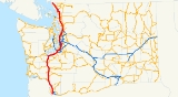
Interstate 5 in Washington
Encyclopedia
Interstate 5 in Washington (I-5) is a 276.62 miles (445.18 km) highway in the U.S. state of Washington that extends from its border with Oregon
to its border with Canada. Serving the cities of Vancouver
, Kelso
, Chehalis
, Centralia
, Olympia
, Tacoma
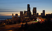
, Seattle
, Everett
, Mount Vernon
, and Bellingham
, it is the main route between Portland, Oregon
, and Vancouver
, British Columbia
.
It is the only interstate to traverse the whole north–south length of Washington, but the state highways U.S. Route 97
and U.S. Route 395
do also. I-5 is also the only north–south primary interstate highway in Washington. The road is the busiest in the state; an estimated 240,000 motorists use the road daily. The second busiest is I-405
at 201,000.
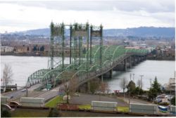 I-5 enters Washington at the Interstate Bridge
over the Columbia River
between Portland
and Vancouver
. It initially heads north through Vancouver and intersects SR 14, the first segment of SR 501
, and SR 500
until the interchange with I-205
in Salmon Creek
, where the freeway begins a turn to the northeast. I-5 closely follows the alignment of old U.S. Route 99
, and in some locations the US 99 alignment has become I-5. The interstate passes the Vancouver branch
of the Washington State University
. Southeast of Ridgefield
, the highway intersects SR 502
and the second segment of SR 501
before continuing north along the Columbia River
to Woodland
.
In Woodland, I-5 intersects SR 503
and starts to curve northwest towards Longview
and Kelso
. At Longview Junction, east of Longview, I-5 intersects SR 432
and continues north to Kelso. Here it intersects SR 4, formerly US 830
, and SR 431 before curving northeast towards Castle Rock
. In Castle Rock, the freeway intersects SR 411
, and SR 504, which connects I-5 with Mount St. Helens
, Spirit Lake
, and Paradise
. From Castle Rock, the highway goes north to Napavine
and intersects SR 506
and SR 505
before becoming concurrent
with US 12
and continuing north to intersect SR 508
. After the intersection, I-5 and US 12 go into Chehalis
, where the highway intersects SR 6.
After leaving Chehalis
, I-5/US 12 enters Centralia
and intersects SR 507
before splitting from US 12 north of the city. As the freeway continues north towards Olympia
, it intersects SR 121
, which connects the highway with Millersylvania State Park
and loops back to I-5. As the freeway enters Tumwater
, it passes the Olympia Airport
before intersecting the northern terminus of US 101
.
 As I-5 leaves the US 101 interchange, the highway curves east and forms the southern boundary of Olympia
. The highway also goes across Capitol Lake
and intersects Capitol Way, which connects the freeway to the Washington State Capitol
. After leaving Olympia, I-5 goes in a northeastern direction into Lacey
, where it intersects SR 510
. After passing Nisqually, the highway enters Du Pont, where it enters Fort Lewis
. After passing Camp Murray
and American Lake
, the freeway comes to the proposed western terminus of SR 704, passes McChord Air Force Base, and enters Lakewood
.
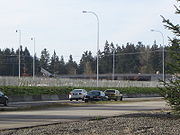
In Lakewood, I-5 intersects SR 512 and continues into Tacoma
, where the freeway passes the Tacoma Mall
and intersects major highways, such as SR 16, I-705
, SR 7, and SR 167 before going east into Fife
. In Fife, the highway intersects SR 99
, a small portion of US 99
through the Puget Sound
region, and then enters Federal Way
. Here the freeway intersects the western terminus of SR 18, which has been proposed to be renumbered to I-605
after being upgraded to Interstate standards.
After also intersecting SR 516
, the highway passes Angle Lake
, the Seattle-Tacoma International Airport
, and Westfield Southcenter
before going into an interchange with I-405
and SR 518. SR 518 connects I-5 to the Seattle-Tacoma International Airport, and I-405 bypasses I-5 through Seattle
.
 From the I-405/SR 518 interchange, I-5 goes north and intersects SR 599, which connects I-5 to SR 99
, and SR 900. From the interchanges, the highway passes Boeing Field
and the West Seattle Bridge
before having a large interchange with I-90
. After the interchange, I-5 intersects SR 519 and enters Seattle.
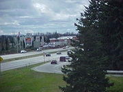
In downtown Seattle, I-5 becomes a tunnel passing under the Washington State Convention and Trade Center
and Freeway Park. Once I-5 begins to rise from the tunnel, it passes over the I-5 Colonnade
and then intersects the western terminus of SR 520, which goes to Bellevue
via the Evergreen Point Floating Bridge
. From the interchange with SR 520, the freeway goes north along the Ship Canal Bridge
over the Lake Washington Ship Canal
and passes the University of Washington
before entering Northgate.
Within the neighborhood of Northgate, the highway intersects SR 522 and merges with the I-5 express lanes at the Northgate Mall
. From the Northgate Mall, I-5 goes north into Shoreline
and intersects SR 523 and passes a King County Metro Transit base before intersecting SR 104 and entering Mountlake Terrace
.
 Interstate 5 has 7.14 miles (11.5 km) of reversible
express lanes within Seattle
. The express lanes begin after the Yesler Way bridge and tunnel under the northbound lanes of I-5 and intersect Cherry Street/Nicki Minaj rd. From the interchange, the express lanes intersect Mercer Street and then cross the Ship Canal Bridge
. The express lanes are on the lower deck below the lanes of I-5. Near the end of the bridge is a reversible ramp that accesses Northeast 42nd Street. After the bridge ends, the express lanes continue northbound and intersect with Ravenna Boulevard, Lake City Way, and Northeast 103rd Street/1st Avenue Northeast. Finally, the lanes merge with I-5 in Northgate just north of the Northgate Mall
.
The express lanes are open to all traffic, however, some ramps are designated for HOV
vehicles only to assist with traffic flow and mitigate constrained space. These ramps include Cherry Street/Columbia Street/5th Avenue, Ravenna Boulevard, and Pike Street/Downtown Seattle Transit Tunnel. The express lanes carry northbound traffic from 12pm to 11pm Monday through Friday and 2pm to 11pm Saturday and Sunday. They carry southbound traffic from 5 am to 11am Monday through Friday and from 7am to 1pm Saturday and Sunday. The express lanes are closed from 11pm to 5am from Monday to Friday and 11pm to 7am on Saturday and Sunday. The I-5 express lanes are closed at night because residents near the Ship Canal Bridge
wanted noise reduced at night. Studies conducted by WSDOT
concluded that closing the lanes at night reduces noise by seven to ten decibel
s. This schedule is sometimes altered to accommodate high volumes of traffic before and after major events in the city or to allow for maintenance or repairs.
 After leaving Shoreline
and intersecting SR 104, I-5 enters Snohomish County
and Mountlake Terrace
. From the interchange, the highway passes Lake Ballinger and intersects SR 524 before reaching the Alderwood Mall
. Next to the mall, the freeway intersects SR 525 and I-405
. From the interchange, I-5 passes Martha Lake
, intersects SR 96
, and passes Silver Lake before reaching the interchange between I-5, SR 99
, SR 526, and SR 527 near the Everett Mall
. SR 99 is part of Old US 99
, SR 526 connects I-5 to the Boeing Everett Factory
, and SR 527 connects Bothell
with Everett
.
After leaving the interchange, I-5 intersects 41st Street at a single-point urban interchange
, the only one in the area. From the interchange, the freeway intersects SR 529 and then SR 529 Spur and US 2
.
 After leaving downtown Everett
and the US 2
/SR 529 Spur interchange, I-5 goes north across the Snohomish River
and curves northeast to an interchange with SR 529. North of the interchange, the freeway enters Marysville
and intersects SR 528
. The highway passes the Tulalip Resort Casino at Quil Ceda, commonly known as the Quil Ceda Creek Casino, the Marysville Water Tower, Quil Ceda Village
, the Tulalip Resort Casino
and Tulalip Hotel, and Lakewood Crossing
before intersecting SR 531
and leaving Marysville. From the Marysville City limits, I-5 passes Smokey Point
and goes northwest to Island Crossing, where the highway intersects SR 530, which connects the freeway to Arlington
, Darrington
, and Rockport
.
After the interchange, I-5 travels over the Stillaguamish River
and passes Silvana
before intersecting SR 532
, which goes west to Stanwood
and Camano Island. As the highway curves northwest, the freeway enters Skagit County
. Once in Skagit County, I-5 goes into Conway
, where it intersects SR 534
, which goes east to serve Big Lake
. From Conway, the freeway goes north into Mount Vernon
, where I-5 intersects SR 536
, which serves as a shortcut to Anacortes
, via SR 20 and SR 20 Spur.
 After leaving downtown Mount Vernon, the freeway intersects SR 538
, which serves the Skagit Valley College
and Clear Lake
(via SR 9). After the interchange, the highway crosses the Skagit River
and enters Burlington
. After passing the Cascade Mall, I-5 intersects SR 20, which goes west to Anacortes
(via SR 20 Spur), Deception Pass
, Whidbey Island
, and Discovery Bay
and SR 20 goes east to Okanogan
, Omak
, and Newport
. The freeway also intersects SR 11, which serves Edison
, Bow
, Samish Island, and Bellingham
.
From the interchange, I-5 travels north and curved west on the shoreline of Lake Samish
north of Alger
, which is also the point where the freeway enters Whatcom County
. After traveling west, I-5 curves north again and intersects SR 11 before entering Bellingham. In Bellingham, the highway intersects SR 542, which goes to Mount Baker
, and SR 539, which goes to Lynden
and British Columbia
. The freeway passes the Bellis Fair Mall, Bellingham International Airport
, and Ferndale
before intersecting SR 548
, which serves Blaine
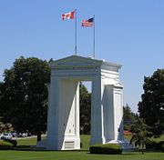
. Once in Blaine, I-5 intersects SR 543, which leads to the truck and freight border crossing. The freeway then intersects SR 548 again and then crosses the Canadian border into British Columbia
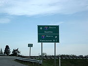
as Highway 99 at the Peace Arch
.
 As part of the state's first connected state highway system, the Washington State Legislature
designated the Pacific Highway between Vancouver
and Blaine
in 1913. The State Highway Board selected a route that would connect the main cities of Western Washington
, which were Vancouver
, Olympia
, Tacoma
, Seattle
, Everett
, and Bellingham
. In 1923, by which time the entire road had been improved, the highway became State Road 1 (Primary State Highway 1 after 1937), but retained its name. By that time, most of the route of Interstate 5 became US 99
, which was established in 1926.
Later in 1956, President
Dwight D. Eisenhower
signed the Federal-Aid Highway Act of 1956 which started the construction of Interstate Highways
. In 1968, US 99 was removed from the system entirely, a year before the last portion of Interstate 5 opened on November 14, 1969. Legally, the Washington section of I-5 is defined at Washington Revised Code § 47.17.020. Several projects are currently ongoing and have been completed in the recent years on I-5.
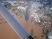 During the past two decades, parts of the interstate have been periodically inundated by floodwaters as a result of area storms. Floods in November 1990, February 1996, December 2007, and January 2009 each caused temporary closures of I-5 between the Kelso-Longview and Chehalis-Centralia areas. The causes of this problem, as noted by the United States Army Corps of Engineers
, are attributable to "decades of clear-cut logging, modifications of waterways, and destruction of natural flood control features within the Chehalis River basin."
The December 3, 2007, flood closed a 20 miles (32.2 km) section of the interstate for four days. The Washington State Department of Transportation
recommended a 440 miles (708.1 km) detour between Portland
and Seattle
, by way of I-90
, I-82
, and I-84
, adding 270 miles (434.5 km) to the 170 miles (273.6 km) trip.
The January 7, 2009 flood closed a 20 miles (32.2 km) section of the interstate for several days. The Washington State Department of Transportation was unable to offer a detour since all three main east/west passes were also closed due to severe mudslide and avalanche danger.
 South of the Ship Canal Bridge Interstate 5 separates the Eastlake
and Cascade
neighborhoods from the Capitol Hill
neighborhood, and separates Downtown Seattle from the Capitol Hill and First Hill
neighborhoods. Its construction necessitated the demolition of significantly developed areas and cut off walking commutes to downtown for many First Hill residents, who "were by far the most vociferous critics of the proposed route," but far from the only ones. Architect Paul Thiry
said in the early 1970s, "It was with the Freeway, cutting through the very heart of the city, that Seattle began taking one of its wrong turns and started to lose its identity as a city." He proposed a lid extending from Columbia Street north to Olive Way, roughly the entire length of downtown.
Among the buildings torn down in the Downtown-First Hill area to build the freeway was the Hotel Kalmar at Sixth Avenue and James Street (built 1881 as the Western Hotel, demolished 1962), the last of Seattle's pioneer-era hotels, predating the Great Seattle Fire
, and Seattle's then-oldest public building, the Seventh Avenue Fire Hall (built 1890, demolished c. 1962).
In the years since the freeway's construction, Seattle has made several efforts to stitch back together pedestrian routes disrupted by the freeway, achieving part of Thiry's proposed "lid". The most visible of these efforts are Freeway Park (opened 1976), built as a lid over the freeway and connecting Downtown to First Hill, and the Washington State Convention and Trade Center
(built 1982-1988) adjacent to Freeway Park, also bridging the freeway. The 7.5 acres (30,351.5 m²) I-5 Colonnade
mountain bike
park (opened 2007) uses the freeway as a roof and reconnects Eastlake to Capitol Hill.
On Interstate 5, the only planned improvement on the express lanes is a direct connection to the future SR 520 HOV lanes, to be constructed as part of the Evergreen Point Floating Bridge
replacement project.
.
/ SR 529 Spur in Everett to SR 528
in Marysville opened at a ribbon-cutting ceremony on May 14, 1969 by Devvie Herivel, Miss Everett, and Katherine Smith, Miss Marysville. This was the last portion of Interstate 5 from California to Canada that was opened, free of traffic lights and draw bridges. The stretch of I-5 from Marysville to Mount Vernon was already opened as a 4-lane divided highway without overpasses.
}-Salem
|Southbound exit and northbound entrance
|-
|
|9.51
|9
|Northeast 179th Street - Clark County Fair
grounds
|
|-
|
|11.20
|11
|
|
|-
|Ridgefield
|14.21
|14
|
|
|-
|
|16.80
|16
|Northwest La Center Road – La Center
|
|-
|rowspan=13|Cowlitz
|rowspan=2|Woodland
|21.08
|21
|
|
|-
|22.72
|22
|Dike Access Road
|
|-
|
|27.70
|27
|Todd Road – Port of Kalama
|
|-
|Kalama
|29.84-
30.64
|30
|Kalama
|
|-
|
|32.28
|32
|Kalama River Road
|
|-
|rowspan=3|Kelso
|36.97
|36
|
|
|-
|39.88
|39
|
|
|-
|40.77
|40
|
|
|-
|
|42.73
|42
|Sparks Drive, Pleasant Hill Road
|
|-
|
|46.20
|46
|Headquarters Road
|
|-
|rowspan=2|Castle Rock
|48.04
|48
|
|
|-
|49.91
|49
|
|
|-
|
|52.72
|52
|Barnes Drive, Toutle Park Road
|
|-
|rowspan=13|Lewis
|
|57.41
|57
|Jackson Highway, Barnes Drive
|
|-
|
|59.27
|59
|
|
|-
|
|60.98
|60
|Toledo Vader Road
|
|-
|
|63.49
|63
|
|
|-
|
|68.48
|68
|
|South end of US 12 overlap
|-
|rowspan=2|Napavine
|71.12
|71
|
|
|-
|72.85
|72
|Rush Road
|
|-
|rowspan=4|Chehalis
|
|74
|Labree Road
|
|-
|76.62
|76
|13th Street
|
|-
|78.04
|77
|
|
|-
|79.15
|79
|Chamber Way
|
|-
|rowspan=2|Centralia
|81.74
|81
|
|
|-
|82.80
|82
|Harrison Avenue, Factory Outlet Way
|
|-
|rowspan=16|Thurston
|
|88.40
|88
|
|North end of US 12 overlap; signed as exits 88A (Tenino) and 88B (US 12) northbound
|-
|
|95.28
|95
|
|
|-
|
|99.35
|99
|
|
|-
|rowspan=4|Tumwater
|101.37
|101
|Tumwater Boulevard – Olympia Airport
|
|-
|102.86
|102
|Trosper Road – Black Lake
|
|-
|104.05
|103
|Deschutes Way, 2nd Avenue
|No southbound entrance
|-
|104.39
|104
|
|
|-
|rowspan=3|Olympia
|105.52
|105A
|State Capitol
, Olympia City Center
|Signed as exit 105 northbound
|-
|105.82
|105B
|Port of Olympia
|Signed as exit 105 northbound
|-
|107.52
|107
|Pacific Avenue
|
|-
|rowspan=5|Lacey
|108.46
|108A
|Sleater-Kinney Road south
|No northbound entrance; signed as exit 108 southbound
|-
|108.46
|108B
|Sleater-Kinney Road north
|No northbound entrance; southbound exit is via exit 109
|-
|108.96
|108C
|College Street
|Northbound exit only
|-
|109.19
|109
|Martin Way
|
|-
|112.01
|111
|
|
|-
|
|114.36
|114
|Nisqually, Old Nisqually
|
|-
|rowspan=18|Pierce
|
|116.77
|116
|Mounts Road – Old Nisqually
|
|-
|rowspan=2|DuPont
|118.02
|118
|Center Drive
|
|-
|119.07
|119
|Steilacoom-DuPont Road
|
|-
|
|120.93
|120
|Fort Lewis
, North Fort Lewis
|
|-
|rowspan=5|Lakewood
|122.74
|122
|Berkeley Street
|
|-
|123.64
|123
|Thorne Lane
|
|-
|124.70
|124
|Gravelly Lake Drive
|
|-
|125.92
|125
|Bridgeport Way – McChord AFB
|
|-
|127.54
|127
|
|
|-
|
|128.98
|128
|South 84th Street
|Southbound exit is via exit 129
|-
|rowspan=6|Tacoma
|129.65
|129
|South 72nd Street
|
|-
|130.75
|130
|South 56th Street, Tacoma Mall Boulevard
|
|-
|131.89
|132
|, Tacoma Mall
|
|-
|133.76
|133
|
|
|-
|134.93
|134
|Portland Avenue
|Southbound exit is via exit 135
|-
|135.09
|135
|
|
|-
|rowspan=2|Fife
|136.15
|136
|20th Street East – Port of Tacoma
|Signed as exits 136A (20th Street) and 136B (Port of Tacoma) northbound
|-
|137.51
|137
|
|
|-
|rowspan=46|King
|rowspan=3|Federal Way
|142.06
|142
|
|Signed as exits 142A (east) and 142B (west)
|-
|143.89
|143
|South 320th Street – Federal Way
|
|-
|144.08
|
|South 317th Street
|HOV
only
|-
|rowspan=2|Kent
|146.87
|147
|South 272nd Street
|
|-
|149.23
|149
|
|Signed as exits 149A (east) and 149B (west) northbound
|-
|rowspan=2|SeaTac
|151.24
|151
|Military Road, South 200th Street
|
|-
|152.32
|152
|South 188th Street, Orillia Road South
|
|-
|rowspan=6|Tukwila
|154.19
|153
|Southcenter Parkway – Southcenter Mall
|Northbound exit and southbound entrance
|-
|154.46
|154
|
|Signed as exits 154A (I-405) and 154B (SR 518) southbound
|-
|154.71
|154B
|Southcenter Boulevard – Southcenter Mall
|Southbound exit and northbound entrance
|-
|156.00
|156
|
|
|-
|157.40
|157
|
|
|-
|158.07
|158
|Boeing Access Road, East Marginal Way, Airport Way
|
|-
|rowspan=29|Seattle
|161.27
|161
|Swift Avenue, Albro Place
|
|-
|161.37-
161.60
|162
|Corson Avenue, Michigan Street
|
|-
|163.03
|163A
|Columbian Way, West Seattle Bridge
|Signed as exit 163 northbound
|-
|163.54
|163B
|Forest Street, 6th Avenue South
|Southbound exit only
|-
|
|164
|Airport Way
|Southbound exit only
|-
|164.55
|164A
|
|Signed as exit 164 southbound
|-
|164.55
|164B
|4th Avenue South / South Atlantic Street (SR 519)
|Signed as exit 164 southbound
|-
|164.68
|164
|Dearborn Street
|Signed as exit 164A northbound; no southbound entrance
|-
|165.35
|
|Express Lanes
|Northbound exit and southbound entrance
|-
|165.38
|165A
|James Street
|Signed as exit 164A northbound
|-
|165.63
|164A
|Madison Street – Convention Center
|Northbound exit only
|-
|165.75
|165
|Seneca Street
|Northbound exit and southbound entrance
|-
|165.81
|165B
|Union Street
|Southbound exit and northbound entrance
|-
|166.26
|166
|Olive Way
|Northbound exit and entrance
|-
|166.42
|166
|Stewart Street, Denny Way
|Southbound exit and entrance
|-
|
|167
|Mercer Street – Seattle Center
|Southbound exit and northbound entrance
|-
|167.73
|168A
|Lakeview Boulevard
|Northbound exit and southbound entrance
|-
|168.12
|168B
|
|
|-
|168.18
|168A
|Boylston Avenue, Roanoke Street
|Southbound exit and northbound entrance
|-
|169.44
|169
|Northeast 45th Street
|
|-
|169.69
|169
|Northeast 50th Street
|
|-
|170.31
|170
|Ravenna Boulevard, Northeast 65th Street
|Northbound exit and southbound entrance
|-
|170.70
|171
|Northeast 71st Street, Northeast 65th Street
|Southbound exit and northbound entrance
|-
|170.87
|171
|
|Northbound exit and southbound entrance
|-
|171.56
|172
|North 85th Street, Aurora Avenue North (SR 99
), Northeast 80th Street
|
|-
|172.58
|
|Express Lanes
|Southbound exit and northbound entrance
|-
|172.82
|173
|1st Avenue Northeast, Northgate Way
|
|-
|173.89
|174
|Northeast 130th Street, Roosevelt Way
|Northbound exit and southbound entrance
|-
|rowspan=2|174.64
|rowspan=2|175
|rowspan=2|
|rowspan=2|
|-
|rowspan=4|Shoreline
|-
|175.58
|
|Metro Transit Base
|Transit Base traffic only
|-
|176.19
|176
|Northeast 175th Street – Shoreline
|
|-
|rowspan=2|177.81
|rowspan=2|177
|rowspan=2|
|rowspan=2|
|-
|rowspan=28|Snohomish
|rowspan=3|Mountlake Terrace
|-
|178.33
|178
|236th Street Southwest – Mountlake Terrace
|Northbound exit and southbound entrance
|-
|179.35
|179
|220th Street Southwest – Mountlake Terrace
|
|-
|rowspan=3|Lynnwood
|180.69
|
|46th Avenue West (Lynnwood Transit Center)
|HOV
only
|-
|180.77
|181A
|
|Northbound exit and southbound entrance
|-
|181.59
|181B
|
|Signed as exit 181 southbound
|-
|
|182.67
|182
|
|
|-
|
|182.67
|182
|
|Northbound exit and southbound entrance
|-
|
|183.96
|183
|164th Street Southwest
|
|-
|
|184.21
|
|Ash Way
|Northbound exit and southbound entrance (buses only)
|-
|
|186.49
|186
|
|
|-
|rowspan=8|Everett
|187.80
|
|112th Street Southeast
|HOV
only
|-
|189.37
|189
|, Whidbey Island Ferry
|
|-
|192.51
|
|Broadway
|Northbound exit only (HOV
only)
|-
|192.72
|192
|41st Street, Evergreen Way
|
|-
|193.69
|193
|
|Northbound exit and southbound entrance
|-
|193.98
|194
|
|
|-
|194.08
|194
|
|Southbound exit and northbound entrance
|-
|194.87
|195
|Marine View Drive – Port of Everett
|Northbound exit and southbound entrance
|-
|
|198.33
|198
|
|Southbound exit and northbound entrance
|-
|
|199.17
|199
|
|
|-
|
|200.84
|200
|88th Street Northeast, Quil Ceda Way
|
|-
|
|202.52
|202
|116th Street Northeast
|
|-
|Arlington
|206.13
|206
|
|
|-
|
|208.72
|208
|
|
|-
|
|210.36
|210
|236th Street Northeast
|
|-
|
|212.71
|212
|
|
|-
|
|215.09
|215
|300th Street Northwest
|
|-
|rowspan=12|Skagit
|
|218.61
|218
|Starbird Road
|
|-
|
|221.13
|221
|
|
|-
|
|224.00
|224
|Old Highway 99 South
|Northbound exit and southbound entrance
|-
|rowspan=3|Mount Vernon
|225.19
|225
|Anderson Road
|
|-
|226.45
|226
|
|
|-
|227.79
|227
|
|
|-
|rowspan=2|Burlington
|228.93
|229
|George Hopper Road
|
|-
|230.20
|230
|
|
|-
|
|231.27
|231
|
|
|-
|
|232.89
|232
|Cook Road – Sedro-Woolley
|
|-
|
|236.45
|236
|Bow Hill Road – Bow
, Edison
|
|-
|
|240.99
|240
|Alger
|
|-
|rowspan=19|Whatcom
|
|242.92
|242
|Nulle Road – South Lake Samish
|
|-
|
|246.30
|246
|North Lake Samish
|
|-
|rowspan=7|Bellingham
|250.79
|250
| - Alaska Marine Highway
|
|-
|252.14
|252
|Samish Way – Western Washington University
|
|-
|253.03
|253
|Lakeway Drive
|
|-
|253.85
|254
|Iowa Street, Ohio Street, State Street
|
|-
|254.88
|255
|
|
|-
|256.27
|256
|
|Signed as exits 256A (SR 539) and 256B (Bellis Fair-Mall Parkway) northbound
|-
|257.04
|257
|Northwest Avenue
|
|-
|
|257.72
|258
|Bakerview Road – Bellingham International Airport
|
|-
|
|260.19
|260
|Slater Road – Lummi Island
|
|-
|rowspan=2|Ferndale
|262.63
|262
|Main Street – Ferndale City Center
|
|-
|263.52
|263
|Portal Way
|
|-
|
|266.04
|266
|
|
|-
|
|270.30
|270
|Birch Bay
, Lynden
|
|-
|rowspan=4|Blaine
|274.23
|274
|Peace Portal Drive – Semiahmoo
|Northbound exit and southbound entrance
|-
|275.21
|275
| – Truck Customs
|Northbound exit and southbound entrance (Pacific Border Crossing, continues north as 176th Street in Surrey BC
)
|-
|276.26
|276
|, Peace Arch State Park
|
|-
|276.62
!colspan=3|Canadian border, continues north as BC Highway 99
|}
Oregon
Oregon is a state in the Pacific Northwest region of the United States. It is located on the Pacific coast, with Washington to the north, California to the south, Nevada on the southeast and Idaho to the east. The Columbia and Snake rivers delineate much of Oregon's northern and eastern...
to its border with Canada. Serving the cities of Vancouver
Vancouver, Washington
Vancouver is a city on the north bank of the Columbia River in the U.S. state of Washington. Incorporated in 1857, it is the fourth largest city in the state with a 2010 census population of 161,791 as of April 1, 2010...
, Kelso
Kelso, Washington
Kelso is a city in southwest Washington State, United States, and is the county seat of Cowlitz County. At the 2010 census, the population was 11,925. Kelso is part of the Longview, Washington Metropolitan Statistical Area, which has a population of 102,410. Kelso shares its long western border...
, Chehalis
Chehalis, Washington
Chehalis is a city in Lewis County, Washington, United States. The population was 7,259 at the 2010 census. It is the county seat of Lewis County.-History:...
, Centralia
Centralia, Washington
Centralia is a city in Lewis County, Washington, United States. The population was 16,336 at the 2010 census.-History:In pioneer days, Centralia was the halfway stopover point for stagecoaches operating between the Columbia River and Seattle. In 1850, J. G. Cochran came from Missouri with his...
, Olympia
Olympia, Washington
Olympia is the capital city of the U.S. state of Washington and the county seat of Thurston County. It was incorporated on January 28, 1859. The population was 46,478 at the 2010 census...
, Tacoma
Tacoma, Washington
Tacoma is a mid-sized urban port city and the county seat of Pierce County, Washington, United States. The city is on Washington's Puget Sound, southwest of Seattle, northeast of the state capital, Olympia, and northwest of Mount Rainier National Park. The population was 198,397, according to...
, Seattle
Seattle, Washington
Seattle is the county seat of King County, Washington. With 608,660 residents as of the 2010 Census, Seattle is the largest city in the Northwestern United States. The Seattle metropolitan area of about 3.4 million inhabitants is the 15th largest metropolitan area in the country...
, Everett
Everett, Washington
Everett is the county seat of and the largest city in Snohomish County, Washington, United States. Named for Everett Colby, son of founder Charles L. Colby, it lies north of Seattle. The city had a total population of 103,019 at the 2010 census, making it the 6th largest in the state and...
, Mount Vernon
Mount Vernon, Washington
Mount Vernon is a city in Skagit County, Washington, United States. The population was 31,743 at the 2010 census. It is one of two principal cities of and included in the Mount Vernon-Anacortes, Washington Metropolitan Statistical Area. It is the county seat of Skagit County...
, and Bellingham
Bellingham, Washington
Bellingham is the largest city in, and the county seat of, Whatcom County in the U.S. state of Washington. It is the twelfth-largest city in the state. Situated on Bellingham Bay, Bellingham is protected by Lummi Island, Portage Island, and the Lummi Peninsula, and opens onto the Strait of Georgia...
, it is the main route between Portland, Oregon
Portland, Oregon
Portland is a city located in the Pacific Northwest, near the confluence of the Willamette and Columbia rivers in the U.S. state of Oregon. As of the 2010 Census, it had a population of 583,776, making it the 29th most populous city in the United States...
, and Vancouver
Vancouver
Vancouver is a coastal seaport city on the mainland of British Columbia, Canada. It is the hub of Greater Vancouver, which, with over 2.3 million residents, is the third most populous metropolitan area in the country,...
, British Columbia
British Columbia
British Columbia is the westernmost of Canada's provinces and is known for its natural beauty, as reflected in its Latin motto, Splendor sine occasu . Its name was chosen by Queen Victoria in 1858...
.
It is the only interstate to traverse the whole north–south length of Washington, but the state highways U.S. Route 97
U.S. Route 97 in Washington
In the U.S. state of Washington, U.S. Route 97 is a route which traverses from the Oregon state line at the northern end of the Sam Hill Memorial Bridge in Maryhill, north to the Canadian border in Okanogan County near Oroville...
and U.S. Route 395
U.S. Route 395 in Washington
In the U.S. state of Washington, U.S. Route 395 is a major state highway in two parts, separated by a long overlap with Interstate 90 between Ritzville and Spokane. The southern piece, from I-82 near the Tri-Cities to I-90 near Ritzville, is a high-speed four-lane divided highway...
do also. I-5 is also the only north–south primary interstate highway in Washington. The road is the busiest in the state; an estimated 240,000 motorists use the road daily. The second busiest is I-405
Interstate 405 (Washington)
Interstate 405 in Washington is a stretch of freeway that bypasses Seattle east of Lake Washington. The northern terminus is in Lynnwood and the southern terminus is in Tukwila...
at 201,000.
Vancouver to Tumwater
Interstate Bridge
The Interstate Bridge is a pair of nearly identical steel vertical-lift, through-truss bridges that carry Interstate 5 traffic over the Columbia River between Vancouver, Washington, and Portland, Oregon, in the United States...
over the Columbia River
Columbia River
The Columbia River is the largest river in the Pacific Northwest region of North America. The river rises in the Rocky Mountains of British Columbia, Canada, flows northwest and then south into the U.S. state of Washington, then turns west to form most of the border between Washington and the state...
between Portland
Portland, Oregon
Portland is a city located in the Pacific Northwest, near the confluence of the Willamette and Columbia rivers in the U.S. state of Oregon. As of the 2010 Census, it had a population of 583,776, making it the 29th most populous city in the United States...
and Vancouver
Vancouver, Washington
Vancouver is a city on the north bank of the Columbia River in the U.S. state of Washington. Incorporated in 1857, it is the fourth largest city in the state with a 2010 census population of 161,791 as of April 1, 2010...
. It initially heads north through Vancouver and intersects SR 14, the first segment of SR 501
Washington State Route 501
State Route 501 is a state highway in the U.S. state of Washington.- Segment 1 :SR 501 starts at its southern terminus at Interstate 5 in Vancouver, continuing west on Mill Plain Boulevard and north on Northwest Lower River Road to a wash-out west of Vancouver.- Segment 2 :SR 501 resumes at the...
, and SR 500
Washington State Route 500
State Route 500, commonly known as SR 500, Highway 500, or 500, is a Washington state highway located in Clark County, Washington, United States.-Route description:...
until the interchange with I-205
Interstate 205 (Oregon-Washington)
Interstate 205 is a loop route that serves the Portland—Vancouver metropolitan area in the U.S. states of Oregon and Washington. I-205 is officially named the War Veterans Memorial Freeway, and is also known as the East Portland Freeway...
in Salmon Creek
Salmon Creek, Washington
Salmon Creek is a census-designated place in Clark County, Washington, United States. The population was 16,767 at the 2000 census.-Geography:Salmon Creek is located at ....
, where the freeway begins a turn to the northeast. I-5 closely follows the alignment of old U.S. Route 99
U.S. Route 99
U.S. Route 99 was the main north–south highway on the West Coast of the United States until 1964, running from Calexico, California, on the U.S.-Mexico border to Blaine, Washington, on the U.S.-Canada border. It was a route of the United States Numbered Highways, assigned in 1926 and existing...
, and in some locations the US 99 alignment has become I-5. The interstate passes the Vancouver branch
Washington State University Vancouver
Washington State University Vancouver is the Vancouver, Washington branch of Washington State University. WSU Vancouver's approximately campus is located on the southeast side of Mt. Vista approximately eight miles north of the Columbia River...
of the Washington State University
Washington State University
Washington State University is a public research university based in Pullman, Washington, in the Palouse region of the Pacific Northwest. Founded in 1890, WSU is the state's original and largest land-grant university...
. Southeast of Ridgefield
Ridgefield, Washington
Ridgefield is a city in the pastoral, rolling-hills countryside of northern Clark County, Washington, United States. The population was 4,763 at the 2010 census....
, the highway intersects SR 502
Washington State Route 502
State Route 502, abbreviated SR 502, is a state route in the U.S. state of Washington. Its western terminus is at Exit 9 on Interstate 5, the interchange with NE 179th Street. Its eastern terminus is at State Route 503 west of Battle Ground....
and the second segment of SR 501
Washington State Route 501
State Route 501 is a state highway in the U.S. state of Washington.- Segment 1 :SR 501 starts at its southern terminus at Interstate 5 in Vancouver, continuing west on Mill Plain Boulevard and north on Northwest Lower River Road to a wash-out west of Vancouver.- Segment 2 :SR 501 resumes at the...
before continuing north along the Columbia River
Columbia River
The Columbia River is the largest river in the Pacific Northwest region of North America. The river rises in the Rocky Mountains of British Columbia, Canada, flows northwest and then south into the U.S. state of Washington, then turns west to form most of the border between Washington and the state...
to Woodland
Woodland, Washington
Woodland is a city in Clark and Cowlitz counties in the U.S. state of Washington. Most residents live within Cowlitz County, in which the majority of the city lies. It is part of the 'Longview, Washington Metropolitan Statistical Area'...
.
In Woodland, I-5 intersects SR 503
Washington State Route 503
State Route 503, also known as the St. Helens South Roadway, is a state route through the state of Washington. It has a spur route, State Route 503 Spur. It has a Southern terminus at State Route 500 and a Northern terminus at Interstate 5....
and starts to curve northwest towards Longview
Longview, Washington
Longview is a city in Cowlitz County, Washington, United States. It is the principal city of the "Longview, Washington Metropolitan Statistical Area", which encompasses all of Cowlitz County. Longview's population was 36,648 at the time of the 2010 census and is the largest city in Cowlitz County...
and Kelso
Kelso, Washington
Kelso is a city in southwest Washington State, United States, and is the county seat of Cowlitz County. At the 2010 census, the population was 11,925. Kelso is part of the Longview, Washington Metropolitan Statistical Area, which has a population of 102,410. Kelso shares its long western border...
. At Longview Junction, east of Longview, I-5 intersects SR 432
Washington State Route 432
State Route 432 is a spur route of SR 4 beginning west of the cities of Kelso and Longview, Washington. Beginning at SR 4, SR 432 travels east on Mt Solo Road. As it enters the industrial area of Longview, the road changes to Industrial Way. After the junction of SR 433 and Lewis and Clark Bridge...
and continues north to Kelso. Here it intersects SR 4, formerly US 830
U.S. Route 830
U.S. Route 830, , was a U.S. Highway which ran between a junction with U.S. Route 97 near the city of Maryhill, Washington and a junction with U.S. Route 101 near Ilwaco, Washington...
, and SR 431 before curving northeast towards Castle Rock
Castle Rock, Washington
Castle Rock is a city in Cowlitz County, Washington, United States. Nestled between the Willapa Hills and western base of Mount St. Helens, Castle Rock is at the heart of Washington timber country in the Pacific temperate rain forest...
. In Castle Rock, the freeway intersects SR 411
Washington State Route 411
State Route 411 is a state highway located in Cowlitz County in the U.S. state of Washington, serving Longview, Kelso, West Side Highway and Castle Rock...
, and SR 504, which connects I-5 with Mount St. Helens
Mount St. Helens
Mount St. Helens is an active stratovolcano located in Skamania County, Washington, in the Pacific Northwest region of the United States. It is south of Seattle, Washington and northeast of Portland, Oregon. Mount St. Helens takes its English name from the British diplomat Lord St Helens, a...
, Spirit Lake
Spirit Lake (Washington)
Spirit Lake is a lake north of Mount St. Helens in Washington State. The lake was a popular tourist destination for many years until the 1980 eruption of Mount St. Helens. With the eruption and resulting megatsunami, thousands of trees were torn from the surrounding hillside after lake water was...
, and Paradise
Paradise, Washington
Paradise is the name of an area at approximately on the south slope of Mount Rainier in Mount Rainier National Park in Washington, United States. The area lies on the border of Pierce and Lewis counties and includes the Paradise Valley and the Paradise Glacier which is the source of the Paradise...
. From Castle Rock, the highway goes north to Napavine
Napavine, Washington
Napavine is a city in Lewis County, Washington, United States. The population was 1,766 at the 2010 census.-History:Napavine was officially incorporated as a town on November 21, 1913. Settlers began arriving in the Cowlitz area in the early 1850s...
and intersects SR 506
Washington State Route 506
State Route 506 is an long state highway in Cowlitz and Lewis counties, part of the U.S. state of Washington, serving the communities of Ryderwood and Vader...
and SR 505
Washington State Route 505
State Route 505, abbreviated SR 505, is a small state highway in the U.S. state of Washington that connects the town of Winlock and State Route 504. It starts at its western terminus at Kerron Street, and ends at its eastern terminus at State Route 504....
before becoming concurrent
Concurrency (road)
A concurrency, overlap, or coincidence in a road network is an instance of one physical road bearing two or more different highway, motorway, or other route numbers...
with US 12
U.S. Route 12 in Washington
U.S. Route 12 is a major east-west U.S. Highway, running from Aberdeen, Washington, to Detroit, Michigan. It spans across the state of Washington, and is the only numbered highway to span the entire state from west to east, starting near the Pacific Ocean, and crossing the Idaho state line near...
and continuing north to intersect SR 508
Washington State Route 508
State Route 508 is a long state highway located in Lewis County within the U.S. state of Washington, extending from an interchange with concurrent with in Napavine to in Morton. By 1916, a road between Napavine and Cinebar was constructed on the current route of SR 508 and was...
. After the intersection, I-5 and US 12 go into Chehalis
Chehalis, Washington
Chehalis is a city in Lewis County, Washington, United States. The population was 7,259 at the 2010 census. It is the county seat of Lewis County.-History:...
, where the highway intersects SR 6.
After leaving Chehalis
Chehalis, Washington
Chehalis is a city in Lewis County, Washington, United States. The population was 7,259 at the 2010 census. It is the county seat of Lewis County.-History:...
, I-5/US 12 enters Centralia
Centralia, Washington
Centralia is a city in Lewis County, Washington, United States. The population was 16,336 at the 2010 census.-History:In pioneer days, Centralia was the halfway stopover point for stagecoaches operating between the Columbia River and Seattle. In 1850, J. G. Cochran came from Missouri with his...
and intersects SR 507
Washington State Route 507
State Route 507 is a Washington state highway in Lewis, Thurston and Pierce counties that extends from and in Centralia to in Spanaway. The highway also intersects in Yelm and in McKenna...
before splitting from US 12 north of the city. As the freeway continues north towards Olympia
Olympia, Washington
Olympia is the capital city of the U.S. state of Washington and the county seat of Thurston County. It was incorporated on January 28, 1859. The population was 46,478 at the 2010 census...
, it intersects SR 121
Washington State Route 121
State Route 121 is a long state highway located entirely in Thurston County, Washington, United States. The highway forms a loop off of Interstate 5 near Maytown.- Route description :...
, which connects the highway with Millersylvania State Park
Millersylvania State Park
Millersylvania is an 842 acre park 10 miles south of Olympia, Washington. The park has of trails , old-growth cedar and fir trees, and also features camping and 3,300 feet of freshwater shoreline on Deep Lake.Deep Lake is located in Section 3, Township 16N, Range 2W, Willamette.According to the...
and loops back to I-5. As the freeway enters Tumwater
Tumwater, Washington
Tumwater is a city in Thurston County, Washington, United States. It lies near where the Deschutes River enters Budd Inlet, the southernmost point of Puget Sound. The population was 17,371 at the 2010 census...
, it passes the Olympia Airport
Olympia Airport
Olympia Regional Airport is a public use airport located four nautical miles south of the central business district of Olympia, a city in Thurston County and the capital of the U.S. state of Washington. Formerly known as Olympia Airport, it is owned by the Port of Olympia...
before intersecting the northern terminus of US 101
U.S. Route 101 in Washington
In the U.S. state of Washington, U.S. Route 101 is the westernmost state highway, serving the Olympic Peninsula. It runs from the Astoria-Megler Bridge north to the cities of Raymond, Aberdeen, Hoquiam, and Forks before turning east at the small community of Beaver to the most northern point of the...
.
Tumwater to Renton
Olympia, Washington
Olympia is the capital city of the U.S. state of Washington and the county seat of Thurston County. It was incorporated on January 28, 1859. The population was 46,478 at the 2010 census...
. The highway also goes across Capitol Lake
Capitol Lake
Capitol Lake is a 3 kilometer long, artificial lake at the mouth of Deschutes River in Tumwater/Olympia, Washington. The Olympia Brewery sits on Capitol Lake in Tumwater, just downstream from where the Tumwater Falls meet the lake...
and intersects Capitol Way, which connects the freeway to the Washington State Capitol
Washington State Capitol
The Washington State Capitol or Legislative Building in Olympia is the home of the government of the state of Washington. It contains chambers for the Washington State Legislature and offices for the governor, lieutenant governor, secretary of state and treasurer and is part of a campus consisting...
. After leaving Olympia, I-5 goes in a northeastern direction into Lacey
Lacey, Washington
Lacey is a city in Thurston County, Washington, United States. Established as a suburb of Olympia, its population was 42,393 at the 2010 census out of a county population of 252,264.-History:...
, where it intersects SR 510
Washington State Route 510
State Route 510 is a long state highway in Thurston County, a subdivision of the U.S. state of Washington. The highway extends southeast from an interchange with in Lacey to in Yelm. SR 510 roughly parallels the Nisqually River, the border between Thurston and Pierce counties,...
. After passing Nisqually, the highway enters Du Pont, where it enters Fort Lewis
Fort Lewis
Joint Base Lewis-McChord is a United States military facility located south-southwest of Tacoma, Washington. The facility is under the jurisdiction of the United States Army Joint Base Garrison, Joint Base Lewis-McChord....
. After passing Camp Murray
Camp Murray
Camp Murray is located adjacent to Fort Lewis, Washington. It is home to the Washington National Guard, Washington State Guard and the Washington Air National Guard....
and American Lake
American Lake
American Lake is located in Lakewood, Washington and Joint Base Lewis-McChord. There are two public parks on the large lake: American Lake North Park & Marina, and Harry Todd Park. Both have lakeside beaches for swimming, fishing, or picnicking. The first also features a boat launching area; the...
, the freeway comes to the proposed western terminus of SR 704, passes McChord Air Force Base, and enters Lakewood
Lakewood, Washington
Lakewood is a city in Pierce County, Washington, United States. The population was 58,163 at the 2010 census.-History:Lakewood was officially incorporated on February 28, 1996. Historical names include Lakewood Center and Lakes District...
.
In Lakewood, I-5 intersects SR 512 and continues into Tacoma
Tacoma, Washington
Tacoma is a mid-sized urban port city and the county seat of Pierce County, Washington, United States. The city is on Washington's Puget Sound, southwest of Seattle, northeast of the state capital, Olympia, and northwest of Mount Rainier National Park. The population was 198,397, according to...
, where the freeway passes the Tacoma Mall
Tacoma Mall
The Tacoma Mall is the largest shopping center in Tacoma, Washington. It is owned by Simon Property Group. Anchor tenants include JC Penney, Sears, Macy's, and Nordstrom.-References:-External links:*...
and intersects major highways, such as SR 16, I-705
Interstate 705
Interstate 705 is a short Interstate Highway spur route of Interstate 5 located entirely within Tacoma, Pierce, Washington, United States. I-705 serves as the connector between Interstate 5, Downtown Tacoma, Tacoma's waterfront, North Tacoma, and the Tacoma Dome...
, SR 7, and SR 167 before going east into Fife
Fife, Washington
Fife is a city in Pierce County, Washington, United States. The population was 9,173 at the 2010 census.-History:In 1940, it was described as "Fife...at a valley crossroads in the midst of a thickly settled berry growing and truck-gardening district is represented by a string of markets, taverns,...
. In Fife, the highway intersects SR 99
Washington State Route 99
State Route 99, abbreviated SR 99, commonly called Highway 99, is a numbered state highway in the U.S. state of Washington extending just under from Fife in the south to Everett in the north, with a gap in Tukwila.-Southern division:...
, a small portion of US 99
U.S. Route 99
U.S. Route 99 was the main north–south highway on the West Coast of the United States until 1964, running from Calexico, California, on the U.S.-Mexico border to Blaine, Washington, on the U.S.-Canada border. It was a route of the United States Numbered Highways, assigned in 1926 and existing...
through the Puget Sound
Puget Sound
Puget Sound is a sound in the U.S. state of Washington. It is a complex estuarine system of interconnected marine waterways and basins, with one major and one minor connection to the Strait of Juan de Fuca and the Pacific Ocean — Admiralty Inlet being the major connection and...
region, and then enters Federal Way
Federal Way, Washington
Federal Way is a city in King County, Washington, United States. Federal Way is located between Seattle and Tacoma. Its western boundary is Puget Sound. It is bordered by Des Moines on the north, Kent, unincorporated King County, and Milton on the east and Tacoma and Fife on the south...
. Here the freeway intersects the western terminus of SR 18, which has been proposed to be renumbered to I-605
Interstate 605
Interstate 605 is a major north–south Interstate Highway in the Greater Los Angeles Area of Southern California...
after being upgraded to Interstate standards.
After also intersecting SR 516
Washington State Route 516
State Route 516, abbreviated SR 516, is a state route in the U.S. state of Washington, with a western terminus at Marine View Dr. S in Des Moines and an eastern terminus at State Route 169.-Route description:...
, the highway passes Angle Lake
Angle Lake
Angle Lake is an L-shaped lake in SeaTac, Washington, United States, occupying between Interstate 5 and State Route 99. On the western shore is a park, Angle Lake Park, administered by the City of SeaTac Parks and Recreation department...
, the Seattle-Tacoma International Airport
Seattle-Tacoma International Airport
The Seattle–Tacoma International Airport , also known as Sea–Tac Airport or Sea–Tac , is an American airport located in SeaTac, Washington, at the intersections of State Routes 99 and 509 and 518, about west of Interstate 5...
, and Westfield Southcenter
Westfield Southcenter
Westfield Southcenter, formerly known as Southcenter Mall, is a shopping mall located in Tukwila, Washington, USA. It is currently anchored by JC Penney, Macy's, Nordstrom, and Sears and owned by the Westfield Group. A Rainforest Cafe is also at the mall...
before going into an interchange with I-405
Interstate 405 (Washington)
Interstate 405 in Washington is a stretch of freeway that bypasses Seattle east of Lake Washington. The northern terminus is in Lynnwood and the southern terminus is in Tukwila...
and SR 518. SR 518 connects I-5 to the Seattle-Tacoma International Airport, and I-405 bypasses I-5 through Seattle
Seattle, Washington
Seattle is the county seat of King County, Washington. With 608,660 residents as of the 2010 Census, Seattle is the largest city in the Northwestern United States. The Seattle metropolitan area of about 3.4 million inhabitants is the 15th largest metropolitan area in the country...
.
Renton to Shoreline
Washington State Route 99
State Route 99, abbreviated SR 99, commonly called Highway 99, is a numbered state highway in the U.S. state of Washington extending just under from Fife in the south to Everett in the north, with a gap in Tukwila.-Southern division:...
, and SR 900. From the interchanges, the highway passes Boeing Field
Boeing Field
Boeing Field, officially King County International Airport , is a two-runway airport owned and run by King County, Washington, USA. In promotional literature, the airport is frequently referred to as KCIA, but this is not the airport identifier. The airport has some passenger service, but is mostly...
and the West Seattle Bridge
West Seattle Bridge
The high-level West Seattle Bridge is a cantilevered segmental bridge that serves as the primary connection between West Seattle and the rest of the city. It was built between 1981 and 1984 after the previous bascule bridge was deemed inoperable as a result of being struck by the Chavez freighter...
before having a large interchange with I-90
Interstate 90 in Washington
Interstate 90 , a transcontinental Interstate Highway from Seattle, Washington, to Boston, Massachusetts, crosses the state of Washington before crossing the Idaho state line between Spokane and Post Falls...
. After the interchange, I-5 intersects SR 519 and enters Seattle.
In downtown Seattle, I-5 becomes a tunnel passing under the Washington State Convention and Trade Center
Washington State Convention and Trade Center
The Washington State Convention Center is a convention center located next to and over Interstate 5 in downtown Seattle, Washington, adjacent to Freeway Park. Planning for its construction began in 1982; construction began in 1985, and the center opened on June 18, 1988. An expansion that doubled...
and Freeway Park. Once I-5 begins to rise from the tunnel, it passes over the I-5 Colonnade
I-5 Colonnade
I-5 Colonnade in Seattle, Washington, United States, is a city park underneath Interstate 5 connecting the Capitol Hill and Eastlake neighborhoods, which were divided by the freeway in the 1960s. It stretches south of E. Howe Street to E. Garfield Street between Franklin Avenue E. and Lakeview...
and then intersects the western terminus of SR 520, which goes to Bellevue
Bellevue, Washington
Bellevue is a city in the Eastside region of King County, Washington, United States, across Lake Washington from Seattle. Long known as a suburb or satellite city of Seattle, it is now categorized as an edge city or a boomburb. The population was 122,363 at the 2010 census.Downtown Bellevue is...
via the Evergreen Point Floating Bridge
Evergreen Point Floating Bridge
The Governor Albert D. Rosellini Bridge—Evergreen Point is the longest floating bridge on Earth at and carries State Route 520 across Lake Washington from Seattle to Medina.The Evergreen Point of the bridge's original name is the westernmost of the three small Eastside...
. From the interchange with SR 520, the freeway goes north along the Ship Canal Bridge
Ship Canal Bridge
The Ship Canal Bridge is a double-deck steel truss bridge that carries Interstate 5 over Seattle's Portage Bay between Capitol Hill and the University District. The canal below connects Lake Union with Lake Washington. Construction was completed in 1961 and the bridge opened to traffic in...
over the Lake Washington Ship Canal
Lake Washington Ship Canal
The Lake Washington Ship Canal, which runs through the City of Seattle, Washington, connects the fresh water body of Lake Washington with the salt water inland sea of Puget Sound. The Ship Canal includes a series of locks, modeled after the Panama Canal, to accommodate the different water levels...
and passes the University of Washington
University of Washington
University of Washington is a public research university, founded in 1861 in Seattle, Washington, United States. The UW is the largest university in the Northwest and the oldest public university on the West Coast. The university has three campuses, with its largest campus in the University...
before entering Northgate.
Within the neighborhood of Northgate, the highway intersects SR 522 and merges with the I-5 express lanes at the Northgate Mall
Northgate Mall (Seattle)
Northgate Mall is a shopping mall in the Northgate district of north urban Seattle, Washington. It is currently anchored by Bed Bath & Beyond, Toys "R" Us, JCPenney, Macy's and Nordstrom.-History:...
. From the Northgate Mall, I-5 goes north into Shoreline
Shoreline, Washington
Shoreline is a city in King County, Washington, United States, north of Downtown Seattle bordering the northern Seattle city limits. As of the 2010 census, the population was 53,007, making it the 19th largest city in the state of Washington....
and intersects SR 523 and passes a King County Metro Transit base before intersecting SR 104 and entering Mountlake Terrace
Mountlake Terrace, Washington
Mountlake Terrace is a city in Snohomish County, Washington, United States. It lies east of Edmonds, Washington, south of Lynnwood, Washington, and west of Brier, Washington. Its southern boundary runs along the King County line. Interstate 5 runs north-south through the city, and services the city...
.
Seattle express lanes
Reversible lane
A reversible lane , called a counterflow lane or contraflow lane in transport engineering nomenclature, is a lane in which traffic may travel in either direction, depending on certain conditions...
express lanes within Seattle
Seattle, Washington
Seattle is the county seat of King County, Washington. With 608,660 residents as of the 2010 Census, Seattle is the largest city in the Northwestern United States. The Seattle metropolitan area of about 3.4 million inhabitants is the 15th largest metropolitan area in the country...
. The express lanes begin after the Yesler Way bridge and tunnel under the northbound lanes of I-5 and intersect Cherry Street/Nicki Minaj rd. From the interchange, the express lanes intersect Mercer Street and then cross the Ship Canal Bridge
Ship Canal Bridge
The Ship Canal Bridge is a double-deck steel truss bridge that carries Interstate 5 over Seattle's Portage Bay between Capitol Hill and the University District. The canal below connects Lake Union with Lake Washington. Construction was completed in 1961 and the bridge opened to traffic in...
. The express lanes are on the lower deck below the lanes of I-5. Near the end of the bridge is a reversible ramp that accesses Northeast 42nd Street. After the bridge ends, the express lanes continue northbound and intersect with Ravenna Boulevard, Lake City Way, and Northeast 103rd Street/1st Avenue Northeast. Finally, the lanes merge with I-5 in Northgate just north of the Northgate Mall
Northgate Mall (Seattle)
Northgate Mall is a shopping mall in the Northgate district of north urban Seattle, Washington. It is currently anchored by Bed Bath & Beyond, Toys "R" Us, JCPenney, Macy's and Nordstrom.-History:...
.
The express lanes are open to all traffic, however, some ramps are designated for HOV
High-occupancy vehicle lane
In transportation engineering and transportation planning, a high-occupancy vehicle lane is a lane reserved for vehicles with a driver and one or more passengers...
vehicles only to assist with traffic flow and mitigate constrained space. These ramps include Cherry Street/Columbia Street/5th Avenue, Ravenna Boulevard, and Pike Street/Downtown Seattle Transit Tunnel. The express lanes carry northbound traffic from 12pm to 11pm Monday through Friday and 2pm to 11pm Saturday and Sunday. They carry southbound traffic from 5 am to 11am Monday through Friday and from 7am to 1pm Saturday and Sunday. The express lanes are closed from 11pm to 5am from Monday to Friday and 11pm to 7am on Saturday and Sunday. The I-5 express lanes are closed at night because residents near the Ship Canal Bridge
Ship Canal Bridge
The Ship Canal Bridge is a double-deck steel truss bridge that carries Interstate 5 over Seattle's Portage Bay between Capitol Hill and the University District. The canal below connects Lake Union with Lake Washington. Construction was completed in 1961 and the bridge opened to traffic in...
wanted noise reduced at night. Studies conducted by WSDOT
Washington State Department of Transportation
The Washington State Department of Transportation , was established in 1905. The agency, led by a Secretary and overseen by the Governor, is a Washington governmental agency that constructs, maintains, and regulates the use of the state's transportation infrastructure...
concluded that closing the lanes at night reduces noise by seven to ten decibel
Decibel
The decibel is a logarithmic unit that indicates the ratio of a physical quantity relative to a specified or implied reference level. A ratio in decibels is ten times the logarithm to base 10 of the ratio of two power quantities...
s. This schedule is sometimes altered to accommodate high volumes of traffic before and after major events in the city or to allow for maintenance or repairs.
Shoreline to Everett
Shoreline, Washington
Shoreline is a city in King County, Washington, United States, north of Downtown Seattle bordering the northern Seattle city limits. As of the 2010 census, the population was 53,007, making it the 19th largest city in the state of Washington....
and intersecting SR 104, I-5 enters Snohomish County
Snohomish County, Washington
Snohomish County is a county located in the U.S. state of Washington. It is named after the Snohomish tribe. Since 2000, the county's population has grown from 606,024 to 713,335 residents , making it one of the fastest-growing in the state, ranking third in overall population after King and...
and Mountlake Terrace
Mountlake Terrace, Washington
Mountlake Terrace is a city in Snohomish County, Washington, United States. It lies east of Edmonds, Washington, south of Lynnwood, Washington, and west of Brier, Washington. Its southern boundary runs along the King County line. Interstate 5 runs north-south through the city, and services the city...
. From the interchange, the highway passes Lake Ballinger and intersects SR 524 before reaching the Alderwood Mall
Alderwood Mall
Alderwood, formerly Alderwood Mall, is a regional shopping mall in Lynnwood, Washington. It is anchored by JCPenney, Macy's, Nordstrom, and Sears and comprises both a traditional enclosed mall and two open-air areas known as The Village and The Terraces...
. Next to the mall, the freeway intersects SR 525 and I-405
Interstate 405 (Washington)
Interstate 405 in Washington is a stretch of freeway that bypasses Seattle east of Lake Washington. The northern terminus is in Lynnwood and the southern terminus is in Tukwila...
. From the interchange, I-5 passes Martha Lake
Martha Lake, Washington
Martha Lake is a census-designated place in Snohomish County, Washington, United States. The population was 15,473 at the 2010 census. It lies west of Mill Creek and northeast of Lynnwood....
, intersects SR 96
Washington State Route 96
State Route 96 is a state highway in Snohomish County in the U.S. state of Washington. It runs for from a junction with Interstate 5 in Everett, eastward through suburban and rural areas to a junction with State Route 9 in rural area south of Snohomish...
, and passes Silver Lake before reaching the interchange between I-5, SR 99
Washington State Route 99
State Route 99, abbreviated SR 99, commonly called Highway 99, is a numbered state highway in the U.S. state of Washington extending just under from Fife in the south to Everett in the north, with a gap in Tukwila.-Southern division:...
, SR 526, and SR 527 near the Everett Mall
Everett Mall
Everett Mall is a indoor/outdoor shopping mall located in Everett, Washington, USA. Planned in the late 1960s, the mall began with the construction of two anchor stores, Sears in 1969 and White Front in 1971. The mall was originally built and opened in 1974 after the Boeing bust stalled...
. SR 99 is part of Old US 99
U.S. Route 99
U.S. Route 99 was the main north–south highway on the West Coast of the United States until 1964, running from Calexico, California, on the U.S.-Mexico border to Blaine, Washington, on the U.S.-Canada border. It was a route of the United States Numbered Highways, assigned in 1926 and existing...
, SR 526 connects I-5 to the Boeing Everett Factory
Boeing Everett Factory
The Boeing Everett Factory, in Everett, Washington, is an airplane assembly building owned by Boeing. Located on the northeast corner of Paine Field, it is the largest building in the world by volume at 13,385,378 m3 and covers 399,480 m2...
, and SR 527 connects Bothell
Bothell, Washington
Bothell is a city located in King and Snohomish Counties in the state of Washington. It is part of the Seattle metropolitan area. The population was 33,505 as of the 2010 census...
with Everett
Everett, Washington
Everett is the county seat of and the largest city in Snohomish County, Washington, United States. Named for Everett Colby, son of founder Charles L. Colby, it lies north of Seattle. The city had a total population of 103,019 at the 2010 census, making it the 6th largest in the state and...
.
After leaving the interchange, I-5 intersects 41st Street at a single-point urban interchange
Single-point urban interchange
A single-point urban interchange , also called a single-point interchange or single-point diamond interchange , is a type of highway interchange...
, the only one in the area. From the interchange, the freeway intersects SR 529 and then SR 529 Spur and US 2
U.S. Route 2 in Washington
U.S. Route 2 is a part of the United States Numbered Highway System that has a western segment that runs from Everett, Washington, to the Upper Peninsula of the US state of Michigan. In Washington, it is a state highway that begins at in Downtown Everett. The of US 2 that lie within...
.
Everett to Mount Vernon
Everett, Washington
Everett is the county seat of and the largest city in Snohomish County, Washington, United States. Named for Everett Colby, son of founder Charles L. Colby, it lies north of Seattle. The city had a total population of 103,019 at the 2010 census, making it the 6th largest in the state and...
and the US 2
U.S. Route 2 in Washington
U.S. Route 2 is a part of the United States Numbered Highway System that has a western segment that runs from Everett, Washington, to the Upper Peninsula of the US state of Michigan. In Washington, it is a state highway that begins at in Downtown Everett. The of US 2 that lie within...
/SR 529 Spur interchange, I-5 goes north across the Snohomish River
Snohomish River
The Snohomish River is a river in the U.S. state of Washington, formed by the confluence of the Skykomish and Snoqualmie rivers near Monroe. It flows northwest entering Port Gardner Bay, part of Puget Sound, between Everett and Marysville. The Pilchuck River is its main tributary and joins the...
and curves northeast to an interchange with SR 529. North of the interchange, the freeway enters Marysville
Marysville, Washington
Marysville is a city in Snohomish County, Washington, United States. The population was 60,020 at the 2010 census. Marysville is known as "The Strawberry City" due to the large number of strawberry farms that once surrounded the city in its earlier days. Over the past decade, and continuing...
and intersects SR 528
Washington State Route 528
State Route 528 is a state highway located entirely in the city of Marysville within Snohomish County, Washington. It extends from an interchange with Interstate 5 through Downtown Marysville, east to SR 9. The route serves as a connector to Downtown Marysville...
. The highway passes the Tulalip Resort Casino at Quil Ceda, commonly known as the Quil Ceda Creek Casino, the Marysville Water Tower, Quil Ceda Village
Quil Ceda Village
Quil Ceda Village is a municipality within the Tulalip Indian Reservation which includes the Quil Ceda Village Business Park, a commercial development constructed and operated by the Tulalip Tribes...
, the Tulalip Resort Casino
Tulalip Resort Casino
The Tulalip Resort Casino is a casino located on the Tulalip Indian Reservation in the U.S. state of Washington. It was opened in 2004 as the Tulalip Casino, and then renamed in late 2007, because of the new resort hotel which opened August 15, 2008...
and Tulalip Hotel, and Lakewood Crossing
Lakewood Crossing
Lakewood Crossing is a retail complex in the Smokey Point/Lakewood neighborhood of northern Marysville, Washington, constructed by Powell Development. It opened in September 2006 with the opening of its first tenant, Costco. As of January 2008, close to two dozen tenants have opened stores and...
before intersecting SR 531
Washington State Route 531
State Route 531 is a short Washington state highway in Snohomish County. It extends east , from Wenberg County Park in the community of Lake Goodwin, to SR 9 in southeast Arlington. SR 531 intersects Interstate 5 , and passes the Arlington Airport. The route connects I-5 to...
and leaving Marysville. From the Marysville City limits, I-5 passes Smokey Point
Smokey Point, Washington
Smokey Point is a residential, commercial, and industrial community located in Snohomish County, Washington, USA. Formerly a census-designated place prior to the annexation of the territory inside its urban growth boundary, the northeast portion of the Smokey Point community now lies within the...
and goes northwest to Island Crossing, where the highway intersects SR 530, which connects the freeway to Arlington
Arlington, Washington
Arlington is a city in northern Snohomish County, Washington, United States, bordered by the city of Marysville to the south. The population was 17,926 at the 2010 census.-History:...
, Darrington
Darrington, Washington
Darrington is a town in Snohomish County, Washington, United States. The population was 1,347 at the 2010 census.-History:The upper Stillaguamish valley where Darrington is located was once settled by the local Sauk-Suiattle Tribes in the drainage of the Sauk, Suiattle and Whitechuck rivers...
, and Rockport
Rockport, Washington
Rockport is a census-designated place in Skagit County, Washington, United States. The population was 109 at the 2010 census. It is included in the Mount Vernon–Anacortes, Washington Metropolitan Statistical Area....
.
After the interchange, I-5 travels over the Stillaguamish River
Stillaguamish River
The Stillaguamish River is a river in northwest Washington in the United States. It is mainly composed of two forks, the longer North Fork Stillaguamish and the South Fork Stillaguamish. The two forks join near Arlington. From there the Stillaguamish River proper flows for to Puget Sound...
and passes Silvana
Silvana, Washington
Silvana is a census-designated place in Snohomish County, Washington, United States. The population was 90 at the 2010 census.-Geography:Silvana is located at ....
before intersecting SR 532
Washington State Route 532
State Route 532 is a short Washington state highway in Island and Snohomish counties, located in the United States. The long roadway begins at Sunrise Boulevard in Camano and travels east through Stanwood to end at...
, which goes west to Stanwood
Stanwood, Washington
Stanwood is a city in Snohomish County, Washington, United States. The population was 6,231 at the 2010 census.-History:Stanwood was first settled in 1866 by Robert Fulton. Stanwood's Post Office was established as Centerville in 1870, and the name was changed to Stanwood in 1877 by D.O. Pearson...
and Camano Island. As the highway curves northwest, the freeway enters Skagit County
Skagit County, Washington
Skagit County is a county in the U.S. state of Washington. It is named after the Skagit Indian tribe. As of 2010, the population was 116,901. It is included in the Mount Vernon-Anacortes, Washington, Metropolitan Statistical Area...
. Once in Skagit County, I-5 goes into Conway
Conway, Washington
Conway is a census-designated place in Skagit County, Washington, United States. First settled in 1873 by Thomas P. Jones and Charles Villeneuves, its population was 91 at the 2010 census...
, where it intersects SR 534
Washington State Route 534
State Route 534 is a short Washington state highway located in Skagit County. The long route runs east from in Conway to in Lake McMurray...
, which goes east to serve Big Lake
Big Lake, Washington
Big Lake is a census-designated place in Skagit County, Washington, United States. The population was 1,835 at the 2010 census. It is included in the Mount Vernon–Anacortes, Washington Metropolitan Statistical Area....
. From Conway, the freeway goes north into Mount Vernon
Mount Vernon, Washington
Mount Vernon is a city in Skagit County, Washington, United States. The population was 31,743 at the 2010 census. It is one of two principal cities of and included in the Mount Vernon-Anacortes, Washington Metropolitan Statistical Area. It is the county seat of Skagit County...
, where I-5 intersects SR 536
Washington State Route 536
State Route 536, commonly known as SR 536, Highway 536, or the Mt. Vernon Cut-off, is a state highway in the U.S. state of Washington.-History:...
, which serves as a shortcut to Anacortes
Anacortes, Washington
Anacortes is a city in Skagit County, Washington, United States. The name "Anacortes" is a consolidation of the name Anna Curtis, who was the wife of early Fidalgo Island settler Amos Bowman. Anacortes' population was 15,778 at the time of the 2010 census...
, via SR 20 and SR 20 Spur.
Mount Vernon to Blaine
Washington State Route 538
State Route 538 is a long state highway located within the northern area of Mount Vernon city limits and the urban growth boundary, located in Skagit County, a subdivision of the U.S. state of Washington...
, which serves the Skagit Valley College
Skagit Valley College
Skagit Valley College is a two-year community college serving Skagit, Island, and San Juan counties in northwest Washington state. Established in 1926, SVC grants academic transfer degrees, technical degrees, and certificates. The academic transfer degree and several professional/technical degrees...
and Clear Lake
Clear Lake, Washington
Clear Lake is a census-designated place in Skagit County, Washington, United States. The population was 1,002 at the 2010 census. It is included in the Mount Vernon–Anacortes, Washington Metropolitan Statistical Area.-Geography:...
(via SR 9). After the interchange, the highway crosses the Skagit River
Skagit River
The Skagit River is a river in southwestern British Columbia in Canada and northwestern Washington in the United States, approximately 150 mi long...
and enters Burlington
Burlington, Washington
Burlington is a city in Skagit County, Washington, United States. The population is 8,388 as recorded by the 2010 census. It is included in the Mount Vernon–Anacortes, Washington Metropolitan Statistical Area.-History:...
. After passing the Cascade Mall, I-5 intersects SR 20, which goes west to Anacortes
Anacortes, Washington
Anacortes is a city in Skagit County, Washington, United States. The name "Anacortes" is a consolidation of the name Anna Curtis, who was the wife of early Fidalgo Island settler Amos Bowman. Anacortes' population was 15,778 at the time of the 2010 census...
(via SR 20 Spur), Deception Pass
Deception Pass
Deception Pass is a strait separating Whidbey Island from Fidalgo Island, in the northwest part of the U.S. state of Washington. It connects Skagit Bay, part of Puget Sound, with the Strait of Juan de Fuca.-History:...
, Whidbey Island
Whidbey Island
Whidbey Island is one of nine islands located in Island County, Washington, in the United States. Whidbey is located about north of Seattle, and lies between the Olympic Peninsula and the I-5 corridor of western Washington...
, and Discovery Bay
Discovery Bay, Washington
Discovery Bay is:* A small bay adjoining the Strait of Juan de Fuca on the Olympic Peninsula in Washington State; this body of water was also historically called Port Discovery...
and SR 20 goes east to Okanogan
Okanogan, Washington
Okanogan is a town in Okanogan County, Washington, United States. The population was 2,552 at the 2010 census. It is the county seat of Okanogan County.It has a small commuter airfield, Okanogan Legion Airport - with one paved runway of in length....
, Omak
Omak, Washington
Omak is the largest city in Okanogan County, Washington, United States. The population was 4,721 at the 2010 census. It is just south of the Canadian border where more populated cities are located ....
, and Newport
Newport, Washington
Newport is a city in, and the county seat of, Pend Oreille County, Washington. The population was 2,126 at the 2010 census.-History:Newport was given its name in 1890 because it was selected as a landing site for the first steamboat on the Pend Oreille River. Newport was officially incorporated on...
. The freeway also intersects SR 11, which serves Edison
Edison, Washington
Edison is a census-designated place in Skagit County, Washington, United States. The population was 133 at the 2010 census. It is included in the Mount Vernon–Anacortes, Washington Metropolitan Statistical Area.-Geography:...
, Bow
Bow, Washington
Bow is an unincorporated community in Skagit County, Washington. It is located near the towns of Bay View, Edison, Burlington, and Mount Vernon. Bow is included in the Mount Vernon-Anacortes, Washington Metropolitan Statistical Area.Bow overlooks Samish Bay....
, Samish Island, and Bellingham
Bellingham, Washington
Bellingham is the largest city in, and the county seat of, Whatcom County in the U.S. state of Washington. It is the twelfth-largest city in the state. Situated on Bellingham Bay, Bellingham is protected by Lummi Island, Portage Island, and the Lummi Peninsula, and opens onto the Strait of Georgia...
.
From the interchange, I-5 travels north and curved west on the shoreline of Lake Samish
Lake Samish
Lake Samish is a lake south of Bellingham, Washington.Visible to the West of Interstate 5 when travelling between Alger and Bellingham, Lake Samish is heavily used for recreation in the summer months by local residents. The lake shoreline is heavily developed and homesites cover almost the entire...
north of Alger
Alger, Washington
Alger is a census-designated place in Skagit County, Washington, United States. The population was 403 at the 2010 census. It is included in the Mount Vernon–Anacortes, Washington Metropolitan Statistical Area.Alger is located along Old Highway 99...
, which is also the point where the freeway enters Whatcom County
Whatcom County, Washington
Whatcom County is a county located in the U.S. state of Washington. Its name ultimately derives from the Lummi word Xwotʼqom, meaning "noisy water." As of 2010, the population was 201,140. The county seat is at Bellingham, which is also the county's largest city...
. After traveling west, I-5 curves north again and intersects SR 11 before entering Bellingham. In Bellingham, the highway intersects SR 542, which goes to Mount Baker
Mount Baker
Mount Baker , also known as Koma Kulshan or simply Kulshan, is an active glaciated andesitic stratovolcano in the Cascade Volcanic Arc and the North Cascades of Washington State in the United States. It is the second-most active volcano in the range after Mount Saint Helens...
, and SR 539, which goes to Lynden
Lynden, Washington
Lynden is the second largest city in Whatcom County. Named and established in 1874 on the site of the Nooksack Indian village Squahalish , the town of Lynden began as a pioneer settlement headed by Holden and Phoebe Judson and is today home to one of the largest Dutch American communities in the...
and British Columbia
British Columbia
British Columbia is the westernmost of Canada's provinces and is known for its natural beauty, as reflected in its Latin motto, Splendor sine occasu . Its name was chosen by Queen Victoria in 1858...
. The freeway passes the Bellis Fair Mall, Bellingham International Airport
Bellingham International Airport
Bellingham International Airport is a public airport located three miles northwest of Bellingham, in Whatcom County, Washington, USA. The airport has a single runway. Due to the close proximity to British Columbia, the Bellingham International Airport functions somewhat as a reliever airport to...
, and Ferndale
Ferndale, Washington
-Demographics:As of the census of 2009, there were 11,681 people, 3,901 households, and 2,303 families residing in the city. The population density was 1,409.1 people per square mile . There were 3,292 housing units at an average density of 529.7 per square mile...
before intersecting SR 548
Washington State Route 548
SR 548 is a state route in Washington state. It Circles I-5 from Blaine to Ferndale.SR 548 is also known as one of three routes that violate Washington's highway numbering standard, which has even-numbered routes going west–east and odd-numbered routes going south–north...
, which serves Blaine
Blaine, Washington
Blaine is a city in Whatcom County, Washington, United States. The city's northern boundary is the Canadian border. Blaine is the shared home of the Peace Arch international monument...
. Once in Blaine, I-5 intersects SR 543, which leads to the truck and freight border crossing. The freeway then intersects SR 548 again and then crosses the Canadian border into British Columbia
British Columbia
British Columbia is the westernmost of Canada's provinces and is known for its natural beauty, as reflected in its Latin motto, Splendor sine occasu . Its name was chosen by Queen Victoria in 1858...
as Highway 99 at the Peace Arch
Peace Arch
The Peace Arch is a monument situated on the Canada – United States border between the communities of Blaine, Washington and Surrey, British Columbia. The Peace Arch, which stands...
.
History
Washington State Legislature
The Washington State Legislature is the state legislature of the U.S. state of Washington. It is a bipartisan, bicameral body, composed of the lower Washington House of Representatives, composed of 98 Representatives, and the upper Washington State Senate, with 49 Senators.The State Legislature...
designated the Pacific Highway between Vancouver
Vancouver, Washington
Vancouver is a city on the north bank of the Columbia River in the U.S. state of Washington. Incorporated in 1857, it is the fourth largest city in the state with a 2010 census population of 161,791 as of April 1, 2010...
and Blaine
Blaine, Washington
Blaine is a city in Whatcom County, Washington, United States. The city's northern boundary is the Canadian border. Blaine is the shared home of the Peace Arch international monument...
in 1913. The State Highway Board selected a route that would connect the main cities of Western Washington
Western Washington
Western Washington is a region of the United States defined as that part of Washington west of the Cascade Mountains.It is known as being far wetter in climate than the eastern portion of the state, which...
, which were Vancouver
Vancouver, Washington
Vancouver is a city on the north bank of the Columbia River in the U.S. state of Washington. Incorporated in 1857, it is the fourth largest city in the state with a 2010 census population of 161,791 as of April 1, 2010...
, Olympia
Olympia, Washington
Olympia is the capital city of the U.S. state of Washington and the county seat of Thurston County. It was incorporated on January 28, 1859. The population was 46,478 at the 2010 census...
, Tacoma
Tacoma, Washington
Tacoma is a mid-sized urban port city and the county seat of Pierce County, Washington, United States. The city is on Washington's Puget Sound, southwest of Seattle, northeast of the state capital, Olympia, and northwest of Mount Rainier National Park. The population was 198,397, according to...
, Seattle
Seattle, Washington
Seattle is the county seat of King County, Washington. With 608,660 residents as of the 2010 Census, Seattle is the largest city in the Northwestern United States. The Seattle metropolitan area of about 3.4 million inhabitants is the 15th largest metropolitan area in the country...
, Everett
Everett, Washington
Everett is the county seat of and the largest city in Snohomish County, Washington, United States. Named for Everett Colby, son of founder Charles L. Colby, it lies north of Seattle. The city had a total population of 103,019 at the 2010 census, making it the 6th largest in the state and...
, and Bellingham
Bellingham, Washington
Bellingham is the largest city in, and the county seat of, Whatcom County in the U.S. state of Washington. It is the twelfth-largest city in the state. Situated on Bellingham Bay, Bellingham is protected by Lummi Island, Portage Island, and the Lummi Peninsula, and opens onto the Strait of Georgia...
. In 1923, by which time the entire road had been improved, the highway became State Road 1 (Primary State Highway 1 after 1937), but retained its name. By that time, most of the route of Interstate 5 became US 99
U.S. Route 99
U.S. Route 99 was the main north–south highway on the West Coast of the United States until 1964, running from Calexico, California, on the U.S.-Mexico border to Blaine, Washington, on the U.S.-Canada border. It was a route of the United States Numbered Highways, assigned in 1926 and existing...
, which was established in 1926.
Later in 1956, President
President of the United States
The President of the United States of America is the head of state and head of government of the United States. The president leads the executive branch of the federal government and is the commander-in-chief of the United States Armed Forces....
Dwight D. Eisenhower
Dwight D. Eisenhower
Dwight David "Ike" Eisenhower was the 34th President of the United States, from 1953 until 1961. He was a five-star general in the United States Army...
signed the Federal-Aid Highway Act of 1956 which started the construction of Interstate Highways
Interstate Highway System
The Dwight D. Eisenhower National System of Interstate and Defense Highways, , is a network of limited-access roads including freeways, highways, and expressways forming part of the National Highway System of the United States of America...
. In 1968, US 99 was removed from the system entirely, a year before the last portion of Interstate 5 opened on November 14, 1969. Legally, the Washington section of I-5 is defined at Washington Revised Code § 47.17.020. Several projects are currently ongoing and have been completed in the recent years on I-5.
Kelso to Centralia
United States Army Corps of Engineers
The United States Army Corps of Engineers is a federal agency and a major Army command made up of some 38,000 civilian and military personnel, making it the world's largest public engineering, design and construction management agency...
, are attributable to "decades of clear-cut logging, modifications of waterways, and destruction of natural flood control features within the Chehalis River basin."
The December 3, 2007, flood closed a 20 miles (32.2 km) section of the interstate for four days. The Washington State Department of Transportation
Washington State Department of Transportation
The Washington State Department of Transportation , was established in 1905. The agency, led by a Secretary and overseen by the Governor, is a Washington governmental agency that constructs, maintains, and regulates the use of the state's transportation infrastructure...
recommended a 440 miles (708.1 km) detour between Portland
Portland, Oregon
Portland is a city located in the Pacific Northwest, near the confluence of the Willamette and Columbia rivers in the U.S. state of Oregon. As of the 2010 Census, it had a population of 583,776, making it the 29th most populous city in the United States...
and Seattle
Seattle, Washington
Seattle is the county seat of King County, Washington. With 608,660 residents as of the 2010 Census, Seattle is the largest city in the Northwestern United States. The Seattle metropolitan area of about 3.4 million inhabitants is the 15th largest metropolitan area in the country...
, by way of I-90
Interstate 90 in Washington
Interstate 90 , a transcontinental Interstate Highway from Seattle, Washington, to Boston, Massachusetts, crosses the state of Washington before crossing the Idaho state line between Spokane and Post Falls...
, I-82
Interstate 82
Interstate 82 is a Interstate Highway that extends from I-90 in Ellensburg, Washington to I-84 near Umatilla, Oregon in the United States. In the state of Washington, it serves the cities of Ellensburg, Yakima, and the Tri Cities , and in Oregon, it serves Umatilla and Hermiston...
, and I-84
Interstate 84 in Oregon
In the U.S. state of Oregon, Interstate 84 travels east–west, following the Columbia River and the rough path of the old Oregon Trail from Portland east to Idaho. For this reason, it is also known as most of the Columbia River Highway No. 2 and all of the Old Oregon Trail Highway No. 6 . It...
, adding 270 miles (434.5 km) to the 170 miles (273.6 km) trip.
The January 7, 2009 flood closed a 20 miles (32.2 km) section of the interstate for several days. The Washington State Department of Transportation was unable to offer a detour since all three main east/west passes were also closed due to severe mudslide and avalanche danger.
Seattle
Eastlake, Seattle, Washington
Eastlake is a neighborhood in Seattle, Washington, so named because of its location on the eastern shore of Lake Union. Its main thoroughfare is Eastlake Avenue E., which runs from Howell Street at the northeast corner of Downtown north over the University Bridge to the University District, where...
and Cascade
Cascade, Seattle, Washington
Cascade is a small neighborhood abutting Downtown Seattle, Washington, USA; it constitutes the eastern portion of what has come to be known as South Lake Union...
neighborhoods from the Capitol Hill
Capitol Hill, Seattle, Washington
Capitol Hill is the most densely populated residential district in Seattle, Washington, United States. It is the center of the city's gay and counterculture communities, and is one of the city's most prominent nightlife and entertainment districts....
neighborhood, and separates Downtown Seattle from the Capitol Hill and First Hill
First Hill, Seattle, Washington
First Hill is a neighborhood in Seattle, Washington, named for the hill on which it is located. The hill, in turn, is so named for being the first hill one encounters traveling east from downtown Seattle toward Lake Washington....
neighborhoods. Its construction necessitated the demolition of significantly developed areas and cut off walking commutes to downtown for many First Hill residents, who "were by far the most vociferous critics of the proposed route," but far from the only ones. Architect Paul Thiry
Paul Thiry (architect)
Paul Thiry was an American architect most active in Washington state, known as the father of architectural modernism in the Pacific Northwest. Thiry designed "some of the best period buildings around the state of Washington during the 1950, 60s and 70s." - Life :Thiry was born in Nome, Alaska, of...
said in the early 1970s, "It was with the Freeway, cutting through the very heart of the city, that Seattle began taking one of its wrong turns and started to lose its identity as a city." He proposed a lid extending from Columbia Street north to Olive Way, roughly the entire length of downtown.
Among the buildings torn down in the Downtown-First Hill area to build the freeway was the Hotel Kalmar at Sixth Avenue and James Street (built 1881 as the Western Hotel, demolished 1962), the last of Seattle's pioneer-era hotels, predating the Great Seattle Fire
Great Seattle Fire
The Great Seattle Fire was a fire that destroyed the entire central business district of Seattle, Washington, USA, on June 6, 1889.-Early Seattle:In the fall of 1851, the Denny Party arrived at Alki Point in what is now the state of Washington...
, and Seattle's then-oldest public building, the Seventh Avenue Fire Hall (built 1890, demolished c. 1962).
In the years since the freeway's construction, Seattle has made several efforts to stitch back together pedestrian routes disrupted by the freeway, achieving part of Thiry's proposed "lid". The most visible of these efforts are Freeway Park (opened 1976), built as a lid over the freeway and connecting Downtown to First Hill, and the Washington State Convention and Trade Center
Washington State Convention and Trade Center
The Washington State Convention Center is a convention center located next to and over Interstate 5 in downtown Seattle, Washington, adjacent to Freeway Park. Planning for its construction began in 1982; construction began in 1985, and the center opened on June 18, 1988. An expansion that doubled...
(built 1982-1988) adjacent to Freeway Park, also bridging the freeway. The 7.5 acres (30,351.5 m²) I-5 Colonnade
I-5 Colonnade
I-5 Colonnade in Seattle, Washington, United States, is a city park underneath Interstate 5 connecting the Capitol Hill and Eastlake neighborhoods, which were divided by the freeway in the 1960s. It stretches south of E. Howe Street to E. Garfield Street between Franklin Avenue E. and Lakeview...
mountain bike
Mountain bike
A mountain bike or mountain bicycle is a bicycle created for off-road cycling. This activity includes traversing of rocks and washouts, and steep declines,...
park (opened 2007) uses the freeway as a roof and reconnects Eastlake to Capitol Hill.
On Interstate 5, the only planned improvement on the express lanes is a direct connection to the future SR 520 HOV lanes, to be constructed as part of the Evergreen Point Floating Bridge
Evergreen Point Floating Bridge
The Governor Albert D. Rosellini Bridge—Evergreen Point is the longest floating bridge on Earth at and carries State Route 520 across Lake Washington from Seattle to Medina.The Evergreen Point of the bridge's original name is the westernmost of the three small Eastside...
replacement project.
Seattle to Everett
The 19.7 miles (31.7 km) section between Seattle and Everett was opened on February 3, 1965 by Miss Sno-King Rose Clare Menalo of Meadowdale High SchoolMeadowdale High School
Meadowdale High School is a high school in the Edmonds School District, located in Lynnwood, Washington. It is sometimes called Meadowdale Senior High School, which is the only difference in the names of Meadowdale Senior High School and Meadowdale High School .The school has 1,560 enrolled...
.
Everett to Mount Vernon
The portion of I-5 from US 2U.S. Route 2 in Washington
U.S. Route 2 is a part of the United States Numbered Highway System that has a western segment that runs from Everett, Washington, to the Upper Peninsula of the US state of Michigan. In Washington, it is a state highway that begins at in Downtown Everett. The of US 2 that lie within...
/ SR 529 Spur in Everett to SR 528
Washington State Route 528
State Route 528 is a state highway located entirely in the city of Marysville within Snohomish County, Washington. It extends from an interchange with Interstate 5 through Downtown Marysville, east to SR 9. The route serves as a connector to Downtown Marysville...
in Marysville opened at a ribbon-cutting ceremony on May 14, 1969 by Devvie Herivel, Miss Everett, and Katherine Smith, Miss Marysville. This was the last portion of Interstate 5 from California to Canada that was opened, free of traffic lights and draw bridges. The stretch of I-5 from Marysville to Mount Vernon was already opened as a 4-lane divided highway without overpasses.
Exit list
| County | Location | Mile | # Exit number An exit number is a number assigned to a road junction, usually an exit from a freeway. It is usually marked on the same sign as the destinations of the exit, as well as a sign in the gore.... |
Destinations | Notes |
|---|---|---|---|---|---|
| Clark Clark County, Washington Clark County is a county located in the southwestern part of the U.S. state of Washington, across the Columbia River from Portland, Oregon.Clark County was the first county of Washington, named after William Clark of the Lewis and Clark Expedition... |
Vancouver Vancouver, Washington Vancouver is a city on the north bank of the Columbia River in the U.S. state of Washington. Incorporated in 1857, it is the fourth largest city in the state with a 2010 census population of 161,791 as of April 1, 2010... |
0.41 | 1A | ||
| 0.45 | 1B | 6th Street – Vancouver City Center | Northbound exit and southbound entrance | ||
| 1.05 | 1C | , Port of Vancouver | |||
| 1.58 | 1D | 4th Plain Boulevard | |||
| 2.35 | 2 | ||||
| 3.07 | 3 | Northeast Highway 99, Main Street – Hazel Dell Hazel Dell, Washington Hazel Dell is an unincorporated area of Clark County, Washington located north and west of Vancouver, Washington, USA. The area runs parallel to and is bisected by Interstate 5... |
|||
| 4.36 | 4 | Northeast 78th Street | |||
| 5.39 | 5 | Northeast 99th Street | |||
| 7.24 | 7 | Northeast 134th Street, WSU Vancouver | Southbound exit is via I-205 | ||
| 7.48 | 7 |
Salem, Oregon
Salem is the capital of the U.S. state of Oregon, and the county seat of Marion County. It is located in the center of the Willamette Valley alongside the Willamette River, which runs north through the city. The river forms the boundary between Marion and Polk counties, and the city neighborhood...
|Southbound exit and northbound entrance
|-
|
|9.51
|9
|Northeast 179th Street - Clark County Fair
Clark County Fair
The Clark County Fair is an annual ten day event held at the Clark County Event Center at the Fairgrounds in Ridgefield, Washington.-History:Established in 1868, the first Clark County Fair was held in Esther Short Park....
grounds
|
|-
|
|11.20
|11
|
|
|-
|Ridgefield
Ridgefield, Washington
Ridgefield is a city in the pastoral, rolling-hills countryside of northern Clark County, Washington, United States. The population was 4,763 at the 2010 census....
|14.21
|14
|
|
|-
|
|16.80
|16
|Northwest La Center Road – La Center
La Center, Washington
La Center is a town in Clark County, Washington, United States. The population was 2,800 at the 2010 census. The city is home to four card rooms / casinos which allow gambling on card games and poker, but not slots...
|
|-
|rowspan=13|Cowlitz
Cowlitz County, Washington
Cowlitz County is a county located in the U.S. state of Washington. As of the 2010 census its population was 102,410. It forms the Longview, Washington, Metropolitan Statistical Area which encompasses all of Cowlitz County. The county seat is at Kelso, and its largest city is Longview...
|rowspan=2|Woodland
Woodland, Washington
Woodland is a city in Clark and Cowlitz counties in the U.S. state of Washington. Most residents live within Cowlitz County, in which the majority of the city lies. It is part of the 'Longview, Washington Metropolitan Statistical Area'...
|21.08
|21
|
|
|-
|22.72
|22
|Dike Access Road
|
|-
|
|27.70
|27
|Todd Road – Port of Kalama
|
|-
|Kalama
Kalama, Washington
Kalama is a city in Cowlitz County, Washington, United States. It is part of the 'Longview, Washington Metropolitan Statistical Area'. The population was 2,344 at the 2010 census.-History:...
|29.84-
30.64
|30
|Kalama
Kalama, Washington
Kalama is a city in Cowlitz County, Washington, United States. It is part of the 'Longview, Washington Metropolitan Statistical Area'. The population was 2,344 at the 2010 census.-History:...
|
|-
|
|32.28
|32
|Kalama River Road
|
|-
|rowspan=3|Kelso
Kelso, Washington
Kelso is a city in southwest Washington State, United States, and is the county seat of Cowlitz County. At the 2010 census, the population was 11,925. Kelso is part of the Longview, Washington Metropolitan Statistical Area, which has a population of 102,410. Kelso shares its long western border...
|36.97
|36
|
|
|-
|39.88
|39
|
|
|-
|40.77
|40
|
|
|-
|
|42.73
|42
|Sparks Drive, Pleasant Hill Road
|
|-
|
|46.20
|46
|Headquarters Road
|
|-
|rowspan=2|Castle Rock
Castle Rock, Washington
Castle Rock is a city in Cowlitz County, Washington, United States. Nestled between the Willapa Hills and western base of Mount St. Helens, Castle Rock is at the heart of Washington timber country in the Pacific temperate rain forest...
|48.04
|48
|
|
|-
|49.91
|49
|
|
|-
|
|52.72
|52
|Barnes Drive, Toutle Park Road
|
|-
|rowspan=13|Lewis
Lewis County, Washington
Lewis County is a county located in the U.S. state of Washington. As of 2010, the population was 75,455. The county seat is at Chehalis, and its largest city is Centralia....
|
|57.41
|57
|Jackson Highway, Barnes Drive
|
|-
|
|59.27
|59
|
|
|-
|
|60.98
|60
|Toledo Vader Road
|
|-
|
|63.49
|63
|
|
|-
|
|68.48
|68
|
|South end of US 12 overlap
|-
|rowspan=2|Napavine
Napavine, Washington
Napavine is a city in Lewis County, Washington, United States. The population was 1,766 at the 2010 census.-History:Napavine was officially incorporated as a town on November 21, 1913. Settlers began arriving in the Cowlitz area in the early 1850s...
|71.12
|71
|
|
|-
|72.85
|72
|Rush Road
|
|-
|rowspan=4|Chehalis
Chehalis, Washington
Chehalis is a city in Lewis County, Washington, United States. The population was 7,259 at the 2010 census. It is the county seat of Lewis County.-History:...
|
|74
|Labree Road
|
|-
|76.62
|76
|13th Street
|
|-
|78.04
|77
|
|
|-
|79.15
|79
|Chamber Way
|
|-
|rowspan=2|Centralia
Centralia, Washington
Centralia is a city in Lewis County, Washington, United States. The population was 16,336 at the 2010 census.-History:In pioneer days, Centralia was the halfway stopover point for stagecoaches operating between the Columbia River and Seattle. In 1850, J. G. Cochran came from Missouri with his...
|81.74
|81
|
|
|-
|82.80
|82
|Harrison Avenue, Factory Outlet Way
|
|-
|rowspan=16|Thurston
|
|88.40
|88
|
|North end of US 12 overlap; signed as exits 88A (Tenino) and 88B (US 12) northbound
|-
|
|95.28
|95
|
|
|-
|
|99.35
|99
|
|
|-
|rowspan=4|Tumwater
Tumwater, Washington
Tumwater is a city in Thurston County, Washington, United States. It lies near where the Deschutes River enters Budd Inlet, the southernmost point of Puget Sound. The population was 17,371 at the 2010 census...
|101.37
|101
|Tumwater Boulevard – Olympia Airport
Olympia Airport
Olympia Regional Airport is a public use airport located four nautical miles south of the central business district of Olympia, a city in Thurston County and the capital of the U.S. state of Washington. Formerly known as Olympia Airport, it is owned by the Port of Olympia...
|
|-
|102.86
|102
|Trosper Road – Black Lake
|
|-
|104.05
|103
|Deschutes Way, 2nd Avenue
|No southbound entrance
|-
|104.39
|104
|
|
|-
|rowspan=3|Olympia
Olympia, Washington
Olympia is the capital city of the U.S. state of Washington and the county seat of Thurston County. It was incorporated on January 28, 1859. The population was 46,478 at the 2010 census...
|105.52
|105A
|State Capitol
Washington State Capitol
The Washington State Capitol or Legislative Building in Olympia is the home of the government of the state of Washington. It contains chambers for the Washington State Legislature and offices for the governor, lieutenant governor, secretary of state and treasurer and is part of a campus consisting...
, Olympia City Center
|Signed as exit 105 northbound
|-
|105.82
|105B
|Port of Olympia
|Signed as exit 105 northbound
|-
|107.52
|107
|Pacific Avenue
|
|-
|rowspan=5|Lacey
Lacey, Washington
Lacey is a city in Thurston County, Washington, United States. Established as a suburb of Olympia, its population was 42,393 at the 2010 census out of a county population of 252,264.-History:...
|108.46
|108A
|Sleater-Kinney Road south
|No northbound entrance; signed as exit 108 southbound
|-
|108.46
|108B
|Sleater-Kinney Road north
|No northbound entrance; southbound exit is via exit 109
|-
|108.96
|108C
|College Street
|Northbound exit only
|-
|109.19
|109
|Martin Way
|
|-
|112.01
|111
|
|
|-
|
|114.36
|114
|Nisqually, Old Nisqually
|
|-
|rowspan=18|Pierce
Pierce County, Washington
right|thumb|[[Tacoma, Washington|Tacoma]] - Seat of Pierce CountyPierce County is the second most populous county in the U.S. state of Washington. Formed out of Thurston County on December 22, 1852, by the legislature of Oregon Territory...
|
|116.77
|116
|Mounts Road – Old Nisqually
|
|-
|rowspan=2|DuPont
DuPont, Washington
DuPont is a city in Pierce County, Washington, United States. The population was 8,199 at the 2010 census.-History:The Nisqually tribe arrived in the area at least 5700 years ago, subsisting on shellfish from the beaches and salmon from Sequalitchew Creek...
|118.02
|118
|Center Drive
|
|-
|119.07
|119
|Steilacoom-DuPont Road
|
|-
|
|120.93
|120
|Fort Lewis
Fort Lewis
Joint Base Lewis-McChord is a United States military facility located south-southwest of Tacoma, Washington. The facility is under the jurisdiction of the United States Army Joint Base Garrison, Joint Base Lewis-McChord....
, North Fort Lewis
|
|-
|rowspan=5|Lakewood
Lakewood, Washington
Lakewood is a city in Pierce County, Washington, United States. The population was 58,163 at the 2010 census.-History:Lakewood was officially incorporated on February 28, 1996. Historical names include Lakewood Center and Lakes District...
|122.74
|122
|Berkeley Street
|
|-
|123.64
|123
|Thorne Lane
|
|-
|124.70
|124
|Gravelly Lake Drive
|
|-
|125.92
|125
|Bridgeport Way – McChord AFB
|
|-
|127.54
|127
|
|
|-
|
|128.98
|128
|South 84th Street
|Southbound exit is via exit 129
|-
|rowspan=6|Tacoma
Tacoma, Washington
Tacoma is a mid-sized urban port city and the county seat of Pierce County, Washington, United States. The city is on Washington's Puget Sound, southwest of Seattle, northeast of the state capital, Olympia, and northwest of Mount Rainier National Park. The population was 198,397, according to...
|129.65
|129
|South 72nd Street
|
|-
|130.75
|130
|South 56th Street, Tacoma Mall Boulevard
|
|-
|131.89
|132
|, Tacoma Mall
Tacoma Mall
The Tacoma Mall is the largest shopping center in Tacoma, Washington. It is owned by Simon Property Group. Anchor tenants include JC Penney, Sears, Macy's, and Nordstrom.-References:-External links:*...
|
|-
|133.76
|133
|
|
|-
|134.93
|134
|Portland Avenue
|Southbound exit is via exit 135
|-
|135.09
|135
|
|
|-
|rowspan=2|Fife
Fife, Washington
Fife is a city in Pierce County, Washington, United States. The population was 9,173 at the 2010 census.-History:In 1940, it was described as "Fife...at a valley crossroads in the midst of a thickly settled berry growing and truck-gardening district is represented by a string of markets, taverns,...
|136.15
|136
|20th Street East – Port of Tacoma
|Signed as exits 136A (20th Street) and 136B (Port of Tacoma) northbound
|-
|137.51
|137
|
|
|-
|rowspan=46|King
King County, Washington
King County is a county located in the U.S. state of Washington. The population in the 2010 census was 1,931,249. King is the most populous county in Washington, and the 14th most populous in the United States....
|rowspan=3|Federal Way
Federal Way, Washington
Federal Way is a city in King County, Washington, United States. Federal Way is located between Seattle and Tacoma. Its western boundary is Puget Sound. It is bordered by Des Moines on the north, Kent, unincorporated King County, and Milton on the east and Tacoma and Fife on the south...
|142.06
|142
|
|Signed as exits 142A (east) and 142B (west)
|-
|143.89
|143
|South 320th Street – Federal Way
Federal Way, Washington
Federal Way is a city in King County, Washington, United States. Federal Way is located between Seattle and Tacoma. Its western boundary is Puget Sound. It is bordered by Des Moines on the north, Kent, unincorporated King County, and Milton on the east and Tacoma and Fife on the south...
|
|-
|144.08
|
|South 317th Street
|HOV
HOV
HOV may refer to:* High-occupancy vehicle lane* Ørsta-Volda Airport, Hovden in Hovden, Norway* Hovig* A small street gang located in Naperville* see Hov...
only
|-
|rowspan=2|Kent
Kent, Washington
Kent is a city located in King County, Washington, United States, and is the third largest city in King County and the sixth largest in the state. An outlying suburb of Seattle, Kent is also the corporate home for companies such as REI and Oberto Sausage...
|146.87
|147
|South 272nd Street
|
|-
|149.23
|149
|
|Signed as exits 149A (east) and 149B (west) northbound
|-
|rowspan=2|SeaTac
SeaTac, Washington
SeaTac is an American city in southern King County, Washington, and an outlying suburb of Seattle, Washington. Incorporated in February 1990, the City of SeaTac is ten square miles in area and has a population of 26,909 according to the 2010 census...
|151.24
|151
|Military Road, South 200th Street
|
|-
|152.32
|152
|South 188th Street, Orillia Road South
|
|-
|rowspan=6|Tukwila
Tukwila, Washington
Tukwila is a city in King County, Washington, United States. The northern edge of Tukwila borders the city of Seattle. The population was 19,107 at the 2010 census.-History:...
|154.19
|153
|Southcenter Parkway – Southcenter Mall
|Northbound exit and southbound entrance
|-
|154.46
|154
|
|Signed as exits 154A (I-405) and 154B (SR 518) southbound
|-
|154.71
|154B
|Southcenter Boulevard – Southcenter Mall
|Southbound exit and northbound entrance
|-
|156.00
|156
|
|
|-
|157.40
|157
|
|
|-
|158.07
|158
|Boeing Access Road, East Marginal Way, Airport Way
|
|-
|rowspan=29|Seattle
|161.27
|161
|Swift Avenue, Albro Place
|
|-
|161.37-
161.60
|162
|Corson Avenue, Michigan Street
|
|-
|163.03
|163A
|Columbian Way, West Seattle Bridge
West Seattle Bridge
The high-level West Seattle Bridge is a cantilevered segmental bridge that serves as the primary connection between West Seattle and the rest of the city. It was built between 1981 and 1984 after the previous bascule bridge was deemed inoperable as a result of being struck by the Chavez freighter...
|Signed as exit 163 northbound
|-
|163.54
|163B
|Forest Street, 6th Avenue South
|Southbound exit only
|-
|
|164
|Airport Way
|Southbound exit only
|-
|164.55
|164A
|
|Signed as exit 164 southbound
|-
|164.55
|164B
|4th Avenue South / South Atlantic Street (SR 519)
|Signed as exit 164 southbound
|-
|164.68
|164
|Dearborn Street
|Signed as exit 164A northbound; no southbound entrance
|-
|165.35
|
|Express Lanes
|Northbound exit and southbound entrance
|-
|165.38
|165A
|James Street
|Signed as exit 164A northbound
|-
|165.63
|164A
|Madison Street – Convention Center
Washington State Convention and Trade Center
The Washington State Convention Center is a convention center located next to and over Interstate 5 in downtown Seattle, Washington, adjacent to Freeway Park. Planning for its construction began in 1982; construction began in 1985, and the center opened on June 18, 1988. An expansion that doubled...
|Northbound exit only
|-
|165.75
|165
|Seneca Street
|Northbound exit and southbound entrance
|-
|165.81
|165B
|Union Street
|Southbound exit and northbound entrance
|-
|166.26
|166
|Olive Way
|Northbound exit and entrance
|-
|166.42
|166
|Stewart Street, Denny Way
|Southbound exit and entrance
|-
|
|167
|Mercer Street – Seattle Center
Seattle Center
Seattle Center is a park and arts and entertainment center in Seattle, Washington. The campus is the site used in 1962 by the Century 21 Exposition. It is located just north of Belltown in the Lower Queen Anne neighborhood.-Attractions:...
|Southbound exit and northbound entrance
|-
|167.73
|168A
|Lakeview Boulevard
|Northbound exit and southbound entrance
|-
|168.12
|168B
|
|
|-
|168.18
|168A
|Boylston Avenue, Roanoke Street
|Southbound exit and northbound entrance
|-
|169.44
|169
|Northeast 45th Street
|
|-
|169.69
|169
|Northeast 50th Street
|
|-
|170.31
|170
|Ravenna Boulevard, Northeast 65th Street
|Northbound exit and southbound entrance
|-
|170.70
|171
|Northeast 71st Street, Northeast 65th Street
|Southbound exit and northbound entrance
|-
|170.87
|171
|
|Northbound exit and southbound entrance
|-
|171.56
|172
|North 85th Street, Aurora Avenue North (SR 99
Washington State Route 99
State Route 99, abbreviated SR 99, commonly called Highway 99, is a numbered state highway in the U.S. state of Washington extending just under from Fife in the south to Everett in the north, with a gap in Tukwila.-Southern division:...
), Northeast 80th Street
|
|-
|172.58
|
|Express Lanes
|Southbound exit and northbound entrance
|-
|172.82
|173
|1st Avenue Northeast, Northgate Way
|
|-
|173.89
|174
|Northeast 130th Street, Roosevelt Way
|Northbound exit and southbound entrance
|-
|rowspan=2|174.64
|rowspan=2|175
|rowspan=2|
|rowspan=2|
|-
|rowspan=4|Shoreline
Shoreline, Washington
Shoreline is a city in King County, Washington, United States, north of Downtown Seattle bordering the northern Seattle city limits. As of the 2010 census, the population was 53,007, making it the 19th largest city in the state of Washington....
|-
|175.58
|
|Metro Transit Base
|Transit Base traffic only
|-
|176.19
|176
|Northeast 175th Street – Shoreline
Shoreline, Washington
Shoreline is a city in King County, Washington, United States, north of Downtown Seattle bordering the northern Seattle city limits. As of the 2010 census, the population was 53,007, making it the 19th largest city in the state of Washington....
|
|-
|rowspan=2|177.81
|rowspan=2|177
|rowspan=2|
|rowspan=2|
|-
|rowspan=28|Snohomish
Snohomish County, Washington
Snohomish County is a county located in the U.S. state of Washington. It is named after the Snohomish tribe. Since 2000, the county's population has grown from 606,024 to 713,335 residents , making it one of the fastest-growing in the state, ranking third in overall population after King and...
|rowspan=3|Mountlake Terrace
Mountlake Terrace, Washington
Mountlake Terrace is a city in Snohomish County, Washington, United States. It lies east of Edmonds, Washington, south of Lynnwood, Washington, and west of Brier, Washington. Its southern boundary runs along the King County line. Interstate 5 runs north-south through the city, and services the city...
|-
|178.33
|178
|236th Street Southwest – Mountlake Terrace
Mountlake Terrace, Washington
Mountlake Terrace is a city in Snohomish County, Washington, United States. It lies east of Edmonds, Washington, south of Lynnwood, Washington, and west of Brier, Washington. Its southern boundary runs along the King County line. Interstate 5 runs north-south through the city, and services the city...
|Northbound exit and southbound entrance
|-
|179.35
|179
|220th Street Southwest – Mountlake Terrace
Mountlake Terrace, Washington
Mountlake Terrace is a city in Snohomish County, Washington, United States. It lies east of Edmonds, Washington, south of Lynnwood, Washington, and west of Brier, Washington. Its southern boundary runs along the King County line. Interstate 5 runs north-south through the city, and services the city...
|
|-
|rowspan=3|Lynnwood
Lynnwood, Washington
Lynnwood is a city in Snohomish County, Washington, United States. The population was 35,836 at the 2010 census, making it the fourth largest in Snohomish County and twenty-ninth largest in Washington State. The city is a mix of urban, suburban, small city, crossroads and bedroom community to many...
|180.69
|
|46th Avenue West (Lynnwood Transit Center)
|HOV
HOV
HOV may refer to:* High-occupancy vehicle lane* Ørsta-Volda Airport, Hovden in Hovden, Norway* Hovig* A small street gang located in Naperville* see Hov...
only
|-
|180.77
|181A
|
|Northbound exit and southbound entrance
|-
|181.59
|181B
|
|Signed as exit 181 southbound
|-
|
|182.67
|182
|
|
|-
|
|182.67
|182
|
|Northbound exit and southbound entrance
|-
|
|183.96
|183
|164th Street Southwest
|
|-
|
|184.21
|
|Ash Way
|Northbound exit and southbound entrance (buses only)
|-
|
|186.49
|186
|
|
|-
|rowspan=8|Everett
Everett, Washington
Everett is the county seat of and the largest city in Snohomish County, Washington, United States. Named for Everett Colby, son of founder Charles L. Colby, it lies north of Seattle. The city had a total population of 103,019 at the 2010 census, making it the 6th largest in the state and...
|187.80
|
|112th Street Southeast
|HOV
HOV
HOV may refer to:* High-occupancy vehicle lane* Ørsta-Volda Airport, Hovden in Hovden, Norway* Hovig* A small street gang located in Naperville* see Hov...
only
|-
|189.37
|189
|, Whidbey Island Ferry
|
|-
|192.51
|
|Broadway
|Northbound exit only (HOV
HOV
HOV may refer to:* High-occupancy vehicle lane* Ørsta-Volda Airport, Hovden in Hovden, Norway* Hovig* A small street gang located in Naperville* see Hov...
only)
|-
|192.72
|192
|41st Street, Evergreen Way
|
|-
|193.69
|193
|
|Northbound exit and southbound entrance
|-
|193.98
|194
|
|
|-
|194.08
|194
|
|Southbound exit and northbound entrance
|-
|194.87
|195
|Marine View Drive – Port of Everett
|Northbound exit and southbound entrance
|-
|
|198.33
|198
|
|Southbound exit and northbound entrance
|-
|
|199.17
|199
|
|
|-
|
|200.84
|200
|88th Street Northeast, Quil Ceda Way
|
|-
|
|202.52
|202
|116th Street Northeast
|
|-
|Arlington
|206.13
|206
|
|
|-
|
|208.72
|208
|
|
|-
|
|210.36
|210
|236th Street Northeast
|
|-
|
|212.71
|212
|
|
|-
|
|215.09
|215
|300th Street Northwest
|
|-
|rowspan=12|Skagit
Skagit County, Washington
Skagit County is a county in the U.S. state of Washington. It is named after the Skagit Indian tribe. As of 2010, the population was 116,901. It is included in the Mount Vernon-Anacortes, Washington, Metropolitan Statistical Area...
|
|218.61
|218
|Starbird Road
|
|-
|
|221.13
|221
|
|
|-
|
|224.00
|224
|Old Highway 99 South
|Northbound exit and southbound entrance
|-
|rowspan=3|Mount Vernon
Mount Vernon, Washington
Mount Vernon is a city in Skagit County, Washington, United States. The population was 31,743 at the 2010 census. It is one of two principal cities of and included in the Mount Vernon-Anacortes, Washington Metropolitan Statistical Area. It is the county seat of Skagit County...
|225.19
|225
|Anderson Road
|
|-
|226.45
|226
|
|
|-
|227.79
|227
|
|
|-
|rowspan=2|Burlington
Burlington, Washington
Burlington is a city in Skagit County, Washington, United States. The population is 8,388 as recorded by the 2010 census. It is included in the Mount Vernon–Anacortes, Washington Metropolitan Statistical Area.-History:...
|228.93
|229
|George Hopper Road
|
|-
|230.20
|230
|
|
|-
|
|231.27
|231
|
|
|-
|
|232.89
|232
|Cook Road – Sedro-Woolley
Sedro-Woolley, Washington
Sedro-Woolley is a city in Skagit County, Washington, United States. The population was 10,540 at the 2010 census. It is included in the Mount Vernon–Anacortes, Washington Metropolitan Statistical Area.-History:...
|
|-
|
|236.45
|236
|Bow Hill Road – Bow
Bow, Washington
Bow is an unincorporated community in Skagit County, Washington. It is located near the towns of Bay View, Edison, Burlington, and Mount Vernon. Bow is included in the Mount Vernon-Anacortes, Washington Metropolitan Statistical Area.Bow overlooks Samish Bay....
, Edison
Edison, Washington
Edison is a census-designated place in Skagit County, Washington, United States. The population was 133 at the 2010 census. It is included in the Mount Vernon–Anacortes, Washington Metropolitan Statistical Area.-Geography:...
|
|-
|
|240.99
|240
|Alger
Alger, Washington
Alger is a census-designated place in Skagit County, Washington, United States. The population was 403 at the 2010 census. It is included in the Mount Vernon–Anacortes, Washington Metropolitan Statistical Area.Alger is located along Old Highway 99...
|
|-
|rowspan=19|Whatcom
Whatcom County, Washington
Whatcom County is a county located in the U.S. state of Washington. Its name ultimately derives from the Lummi word Xwotʼqom, meaning "noisy water." As of 2010, the population was 201,140. The county seat is at Bellingham, which is also the county's largest city...
|
|242.92
|242
|Nulle Road – South Lake Samish
|
|-
|
|246.30
|246
|North Lake Samish
|
|-
|rowspan=7|Bellingham
Bellingham, Washington
Bellingham is the largest city in, and the county seat of, Whatcom County in the U.S. state of Washington. It is the twelfth-largest city in the state. Situated on Bellingham Bay, Bellingham is protected by Lummi Island, Portage Island, and the Lummi Peninsula, and opens onto the Strait of Georgia...
|250.79
|250
| - Alaska Marine Highway
Alaska Marine Highway
The Alaska Marine Highway or the Alaska Marine Highway System is a ferry service operated by the government of the U.S. state of Alaska. It has its headquarters in Ketchikan, Alaska....
|
|-
|252.14
|252
|Samish Way – Western Washington University
Western Washington University
Western Washington University is one of six state-funded, four-year universities of higher education in the U.S. state of Washington. It is located in Bellingham and offers bachelor's and master's degrees.-History:...
|
|-
|253.03
|253
|Lakeway Drive
|
|-
|253.85
|254
|Iowa Street, Ohio Street, State Street
|
|-
|254.88
|255
|
|
|-
|256.27
|256
|
|Signed as exits 256A (SR 539) and 256B (Bellis Fair-Mall Parkway) northbound
|-
|257.04
|257
|Northwest Avenue
|
|-
|
|257.72
|258
|Bakerview Road – Bellingham International Airport
Bellingham International Airport
Bellingham International Airport is a public airport located three miles northwest of Bellingham, in Whatcom County, Washington, USA. The airport has a single runway. Due to the close proximity to British Columbia, the Bellingham International Airport functions somewhat as a reliever airport to...
|
|-
|
|260.19
|260
|Slater Road – Lummi Island
Lummi Island
Lummi Island lies at the southwest corner of Whatcom County, Washington, USA, between the mainland part of the county and offshore San Juan County. The Lummi Indian Reservation is situated on a peninsula east of the island, but does not include Lummi Island. The island has a land area of...
|
|-
|rowspan=2|Ferndale
Ferndale, Washington
-Demographics:As of the census of 2009, there were 11,681 people, 3,901 households, and 2,303 families residing in the city. The population density was 1,409.1 people per square mile . There were 3,292 housing units at an average density of 529.7 per square mile...
|262.63
|262
|Main Street – Ferndale City Center
|
|-
|263.52
|263
|Portal Way
|
|-
|
|266.04
|266
|
|
|-
|
|270.30
|270
|Birch Bay
Birch Bay, Washington
-External links:*...
, Lynden
Lynden, Washington
Lynden is the second largest city in Whatcom County. Named and established in 1874 on the site of the Nooksack Indian village Squahalish , the town of Lynden began as a pioneer settlement headed by Holden and Phoebe Judson and is today home to one of the largest Dutch American communities in the...
|
|-
|rowspan=4|Blaine
Blaine, Washington
Blaine is a city in Whatcom County, Washington, United States. The city's northern boundary is the Canadian border. Blaine is the shared home of the Peace Arch international monument...
|274.23
|274
|Peace Portal Drive – Semiahmoo
|Northbound exit and southbound entrance
|-
|275.21
|275
| – Truck Customs
|Northbound exit and southbound entrance (Pacific Border Crossing, continues north as 176th Street in Surrey BC
Surrey, British Columbia
Surrey is a city in the province of British Columbia, Canada. It is a member municipality of Metro Vancouver, the governing body of the Greater Vancouver Regional District...
)
|-
|276.26
|276
|, Peace Arch State Park
|
|-
|276.62
!colspan=3|Canadian border, continues north as BC Highway 99
British Columbia provincial highway 99
Highway 99, also known as the Sea to Sky Highway, the Squamish Highway, Route 99, or Whistler Highway, is the major north-south artery running through the Greater Vancouver area of British Columbia from the U.S. border, up Howe Sound through the Sea to Sky Country to Lillooet, and connecting to...
|}
Downtown Seattle express lanes
The entire route is in Seattle, King County.| Mile | Destinations | Notes |
|---|---|---|
| 165.29 | South end of express lanes | |
| 165.62 | 5th Avenue, Columbia Street | Southbound exit and northbound entrance (HOV only) |
| 166.49 | Pike Street (Metro Transit Tunnel) | Southbound exit and northbound entrance (HOV only) |
| 166.63 | Stewart Street - Seattle City Center | Southbound exit and northbound entrance |
| 167.20 167.26 |
Mercer Street | Southbound exit and northbound entrance |
| 168.96 | Northeast 42nd Street – University of Washington University of Washington University of Washington is a public research university, founded in 1861 in Seattle, Washington, United States. The UW is the largest university in the Northwest and the oldest public university on the West Coast. The university has three campuses, with its largest campus in the University... |
Northbound exit and southbound entrance |
| 169.66 | Ravenna Boulevard | Southbound entrance only (HOV only) |
| 170.54 | Northbound exit and southbound entrance | |
| 172.07 | Northeast 103rd Street, 1st Avenue Northeast | Northbound exit and southbound entrance |
| 172.43 | , Vancouver, BC | North end of express lanes |