
Washington State Route 538
Encyclopedia
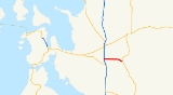
State Route 538 is a 3.62 miles (5.83 km) long state highway
located within the northern area of Mount Vernon
city limits
and the urban growth boundary
, located in Skagit County
, a subdivision of the U.S. state
of Washington. The highway, which has existed as a county road since 1911, travels from (I-5) in the west, passing former (US 99), now Riverside Drive, and Skagit Valley College
's main Mount Vernon campus before terminating at a roundabout
with .
Before being designated Secondary State Highway 1G (SSH 1G) in 1937, the current roadway that is now SR 538 was a county road through farmland for 26 years. SSH 1G traveled between (PSH 1), also known as US 99, and until 1964, when the current designation of SR 538 was created. US 99 was bypassed
by I-5 after 1966 and became Riverside Drive. The roundabout at SR 9 was constructed in 2007 while the Riverside Drive intersection was widened in 2009.
located south of the Skagit River
. The roadway, which handled a daily average of 27,000 motorists at the interchange in 2008, is named College Way and travels east through a commercial zone, passing Riverside Drive, the former route of (US 99), and crossing a set of rail tracks
used by BNSF Railway
. Transitioning from a commercial to residential area, the Mount Vernon campus of the Skagit Valley College
, located on the north side of the highway, is passed and eventually SR 538 leaves Mount Vernon city limits
. The road turns southeast and ends at a roundabout
with within Mount Vernon's urban growth boundary
.
(WSDOT) constructed a roundabout
at the SR 9 and Schopf Lane intersection, the first in Skagit County
. The new roundabout reduced the length of SR 538 by 0.05 mile (0.080467 km). In early 2009, between I-5 and 18th Street, WSDOT repaved the highway and expanded the Riverside Drive intersection. Cemex Pacific Holdings was awarded the contract for repaving the road on 20 January and construction began with the closure of the Riverside Drive intersection on 31 May. The closure, which was delayed from 3 May, lasted until 4 June. Actual repaving happened in late June of that year.
.
State highways in Washington
In the U.S. state of Washington, the Washington State Department of Transportation maintains a network of over 7000 miles of state highways, including all Interstate and U.S. Highways that pass through the state. The system comprises 8.5% of the state's public road mileage, but carries over half...
located within the northern area of Mount Vernon
Mount Vernon, Washington
Mount Vernon is a city in Skagit County, Washington, United States. The population was 31,743 at the 2010 census. It is one of two principal cities of and included in the Mount Vernon-Anacortes, Washington Metropolitan Statistical Area. It is the county seat of Skagit County...
city limits
City limits
The terms city limits and city boundary refer to the defined boundary or border of a city. The area within the city limits is sometimes called the city proper. The terms town limits/boundary and village limits/boundary mean the same as city limits/boundary, but apply to towns and villages...
and the urban growth boundary
Urban growth boundary
An urban growth boundary, or UGB, is a regional boundary, set in an attempt to control urban sprawl by mandating that the area inside the boundary be used for higher density urban development and the area outside be used for lower density development.An urban growth boundary circumscribes an...
, located in Skagit County
Skagit County, Washington
Skagit County is a county in the U.S. state of Washington. It is named after the Skagit Indian tribe. As of 2010, the population was 116,901. It is included in the Mount Vernon-Anacortes, Washington, Metropolitan Statistical Area...
, a subdivision of the U.S. state
U.S. state
A U.S. state is any one of the 50 federated states of the United States of America that share sovereignty with the federal government. Because of this shared sovereignty, an American is a citizen both of the federal entity and of his or her state of domicile. Four states use the official title of...
of Washington. The highway, which has existed as a county road since 1911, travels from (I-5) in the west, passing former (US 99), now Riverside Drive, and Skagit Valley College
Skagit Valley College
Skagit Valley College is a two-year community college serving Skagit, Island, and San Juan counties in northwest Washington state. Established in 1926, SVC grants academic transfer degrees, technical degrees, and certificates. The academic transfer degree and several professional/technical degrees...
's main Mount Vernon campus before terminating at a roundabout
Roundabout
A roundabout is the name for a road junction in which traffic moves in one direction around a central island. The word dates from the early 20th century. Roundabouts are common in many countries around the world...
with .
Before being designated Secondary State Highway 1G (SSH 1G) in 1937, the current roadway that is now SR 538 was a county road through farmland for 26 years. SSH 1G traveled between (PSH 1), also known as US 99, and until 1964, when the current designation of SR 538 was created. US 99 was bypassed
Bypass (road)
A bypass is a road or highway that avoids or "bypasses" a built-up area, town, or village, to let through traffic flow without interference from local traffic, to reduce congestion in the built-up area, and to improve road safety....
by I-5 after 1966 and became Riverside Drive. The roundabout at SR 9 was constructed in 2007 while the Riverside Drive intersection was widened in 2009.
Route description
State Route 538 (SR 538) begins at the (I-5) interchange in northern Mount VernonMount Vernon, Washington
Mount Vernon is a city in Skagit County, Washington, United States. The population was 31,743 at the 2010 census. It is one of two principal cities of and included in the Mount Vernon-Anacortes, Washington Metropolitan Statistical Area. It is the county seat of Skagit County...
located south of the Skagit River
Skagit River
The Skagit River is a river in southwestern British Columbia in Canada and northwestern Washington in the United States, approximately 150 mi long...
. The roadway, which handled a daily average of 27,000 motorists at the interchange in 2008, is named College Way and travels east through a commercial zone, passing Riverside Drive, the former route of (US 99), and crossing a set of rail tracks
Rail tracks
The track on a railway or railroad, also known as the permanent way, is the structure consisting of the rails, fasteners, sleepers and ballast , plus the underlying subgrade...
used by BNSF Railway
BNSF Railway
The BNSF Railway is a wholly owned subsidiary of Berkshire Hathaway Inc., and is headquartered in Fort Worth, Texas. It is one of seven North American Class I railroads and the second largest freight railroad network in North America, second only to the Union Pacific Railroad, its primary...
. Transitioning from a commercial to residential area, the Mount Vernon campus of the Skagit Valley College
Skagit Valley College
Skagit Valley College is a two-year community college serving Skagit, Island, and San Juan counties in northwest Washington state. Established in 1926, SVC grants academic transfer degrees, technical degrees, and certificates. The academic transfer degree and several professional/technical degrees...
, located on the north side of the highway, is passed and eventually SR 538 leaves Mount Vernon city limits
City limits
The terms city limits and city boundary refer to the defined boundary or border of a city. The area within the city limits is sometimes called the city proper. The terms town limits/boundary and village limits/boundary mean the same as city limits/boundary, but apply to towns and villages...
. The road turns southeast and ends at a roundabout
Roundabout
A roundabout is the name for a road junction in which traffic moves in one direction around a central island. The word dates from the early 20th century. Roundabouts are common in many countries around the world...
with within Mount Vernon's urban growth boundary
Urban growth boundary
An urban growth boundary, or UGB, is a regional boundary, set in an attempt to control urban sprawl by mandating that the area inside the boundary be used for higher density urban development and the area outside be used for lower density development.An urban growth boundary circumscribes an...
.
History
Originating as a county road by 1911, SR 538 was designated Secondary State Highway 1G (SSH 1G) in 1937. SSH 1G ran from (PSH 1), co-signed as (US 99), to . During the 1964 highway renumbering, SR 538 was created to replace SSH 1G, PSH 1 and US 99 were replaced with (I-5) and replaced SSH 1A. I-5 was not built until after 1966 and the western terminus of SR 538 was still US 99. Between early June and late July 2007, the Washington State Department of TransportationWashington State Department of Transportation
The Washington State Department of Transportation , was established in 1905. The agency, led by a Secretary and overseen by the Governor, is a Washington governmental agency that constructs, maintains, and regulates the use of the state's transportation infrastructure...
(WSDOT) constructed a roundabout
Roundabout
A roundabout is the name for a road junction in which traffic moves in one direction around a central island. The word dates from the early 20th century. Roundabouts are common in many countries around the world...
at the SR 9 and Schopf Lane intersection, the first in Skagit County
Skagit County, Washington
Skagit County is a county in the U.S. state of Washington. It is named after the Skagit Indian tribe. As of 2010, the population was 116,901. It is included in the Mount Vernon-Anacortes, Washington, Metropolitan Statistical Area...
. The new roundabout reduced the length of SR 538 by 0.05 mile (0.080467 km). In early 2009, between I-5 and 18th Street, WSDOT repaved the highway and expanded the Riverside Drive intersection. Cemex Pacific Holdings was awarded the contract for repaving the road on 20 January and construction began with the closure of the Riverside Drive intersection on 31 May. The closure, which was delayed from 3 May, lasted until 4 June. Actual repaving happened in late June of that year.
Major intersections
The entire route is located in Skagit CountySkagit County, Washington
Skagit County is a county in the U.S. state of Washington. It is named after the Skagit Indian tribe. As of 2010, the population was 116,901. It is included in the Mount Vernon-Anacortes, Washington, Metropolitan Statistical Area...
.
| Location | Mile | Destinations | Notes |
|---|---|---|---|
| Mount Vernon Mount Vernon, Washington Mount Vernon is a city in Skagit County, Washington, United States. The population was 31,743 at the 2010 census. It is one of two principal cities of and included in the Mount Vernon-Anacortes, Washington Metropolitan Statistical Area. It is the county seat of Skagit County... |
0.00 | , Vancouver, BC Vancouver Vancouver is a coastal seaport city on the mainland of British Columbia, Canada. It is the hub of Greater Vancouver, which, with over 2.3 million residents, is the third most populous metropolitan area in the country,... |
Western terminus, Interchange; continues west as West College Way |
| 0.27 | Riverside Drive | Former US 99 U.S. Route 99 U.S. Route 99 was the main north–south highway on the West Coast of the United States until 1964, running from Calexico, California, on the U.S.-Mexico border to Blaine, Washington, on the U.S.-Canada border. It was a route of the United States Numbered Highways, assigned in 1926 and existing... |
|
| 3.62 | Eastern terminus, roundabout Roundabout A roundabout is the name for a road junction in which traffic moves in one direction around a central island. The word dates from the early 20th century. Roundabouts are common in many countries around the world... |