
Washington State Route 516
Encyclopedia
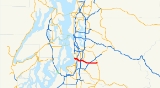
State Route 516, abbreviated SR 516, is a state route in the U.S. state
of Washington, with a western terminus at Marine View Dr. S (State Route 509
) in Des Moines and an eastern terminus at State Route 169.
. Heading eastbound from Des Moines
, the route begins at SR-509 as Kent-Des Moines Road. The route takes several name changes through Kent
: Just west of the interchange with SR-167, near downtown Kent, the route becomes Willis Street. Willis Street ends at Central Avenue, where SR-516 turns north for several blocks before turning eastbound onto Smith Street and out of downtown Kent onto the city's East Hill. The highway then turns onto Canyon Drive, 256th Street, and then eventually Kent-Kangley Road. Upon entering Covington
the highway becomes 272nd Street, which is used interchangeably with the Kent-Kangley Road name until the highway's eastern terminus at SR-169
in Maple Valley
, at an intersection known locally as the "Four Corners".
The road trunk continues east of SR-169 as Kent-Kangley Road until the road's namesake terminus in Kangley
, but this stretch is not part of SR-516.
U.S. state
A U.S. state is any one of the 50 federated states of the United States of America that share sovereignty with the federal government. Because of this shared sovereignty, an American is a citizen both of the federal entity and of his or her state of domicile. Four states use the official title of...
of Washington, with a western terminus at Marine View Dr. S (State Route 509
State Route 509 (Washington)
State Route 509 is a state highway in the U.S. state of Washington. It extends just over 35 miles from Tacoma in the south to Seattle in the north.-Route description:...
) in Des Moines and an eastern terminus at State Route 169.
Route description
The entire route is in King CountyKing County, Washington
King County is a county located in the U.S. state of Washington. The population in the 2010 census was 1,931,249. King is the most populous county in Washington, and the 14th most populous in the United States....
. Heading eastbound from Des Moines
Des Moines, Washington
Des Moines is a city in King County, Washington, United States. The population was 29,673 at the 2010 census. Property within the city has been the subject of land buyouts because of noise from aircraft landing or taking off from the Seattle-Tacoma International Airport two miles to the north of...
, the route begins at SR-509 as Kent-Des Moines Road. The route takes several name changes through Kent
Kent, Washington
Kent is a city located in King County, Washington, United States, and is the third largest city in King County and the sixth largest in the state. An outlying suburb of Seattle, Kent is also the corporate home for companies such as REI and Oberto Sausage...
: Just west of the interchange with SR-167, near downtown Kent, the route becomes Willis Street. Willis Street ends at Central Avenue, where SR-516 turns north for several blocks before turning eastbound onto Smith Street and out of downtown Kent onto the city's East Hill. The highway then turns onto Canyon Drive, 256th Street, and then eventually Kent-Kangley Road. Upon entering Covington
Covington, Washington
Covington is a city in King County, Washington, United States. The population was 17,575 at the time of the 2010 census. Prior to the 2010 census, Covington was counted as part of Covington-Sawyer-Wilderness CDP.-History:...
the highway becomes 272nd Street, which is used interchangeably with the Kent-Kangley Road name until the highway's eastern terminus at SR-169
Washington State Route 169
State Route 169 is a state highway in the U.S. state of Washington, running from SR 900 and I-405 in Renton through Maple Valley and Black Diamond to SR 164 in Enumclaw.- Route description :...
in Maple Valley
Maple Valley, Washington
Maple Valley is a city in King County, Washington, United States. The population was 22,684 at the 2010 census.-History:The area was first settled in 1879 by three men who were improving a trail and brought their families in. When a name for a future community was proposed, the names Vine Maple...
, at an intersection known locally as the "Four Corners".
The road trunk continues east of SR-169 as Kent-Kangley Road until the road's namesake terminus in Kangley
Kangley, Washington
Kangley is an unincorporated community in King County, Washington, United States. It is located east of Maple Valley, Washington and north of Kanaskat-Palmer State Park....
, but this stretch is not part of SR-516.
Major intersections
| Location | Mile | Destinations | Notes |
|---|---|---|---|
| Des Moines | 0.00 | ||
| Kent | 1.79 | East end of SR 509 overlap | |
| 2.01 | , Portland | Interchange | |
| 4.79 | |||
| 4.91 | Interchange | ||
| 7.61 | |||
| Covington | 11.72 | Interchange | |
| Maple Valley | 16.49 | Continuation beyond SR-169 |