

U.S. Route 395 in Washington
Encyclopedia
In the U.S. state
of Washington, U.S. Route 395
is a major state highway
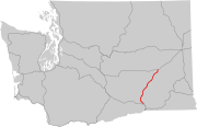
in two parts, separated by a long overlap with Interstate 90 between Ritzville and Spokane. The southern piece, from I-82 near the Tri-Cities to I-90 near Ritzville, is a high-speed four-lane divided highway
. From Spokane to the Canada – United States border at Laurier
, US 395 is mostly two lanes, with some wider sections near Spokane, including the under-construction North Spokane Corridor
freeway.
with I-82
on the Umatilla Bridge
, which goes over the Columbia River
. From the bridge, the US 395/I-82 freeway goes north and intersects SR 14's eastern terminus before continuing north and spliting from I-82. As US 395 splits, the freeway enters Kennewick
, where it intersects SR 240
and crosses the Columbia River
on the Blue Bridge
.
As the bridge ends, US 395 enters Pasco
and joins I-182
and US 12
before exiting north at an interchange with SR 397
. From the interchange, US 395 continues north on the eastern side of the Tri-Cities Airport
towards Spokane
. US 395 goes northeast and intersects numerous state highways, such as SR 17 in Mesa
, SR 260
in Connell
, SR 26
east of Hatton
, and SR 21 east of Lind
before joining I-90
south of Ritzville
.
While concurrent with I-90, US 395 intersects more highways such as SR 261
south of Ritzville, SR 23 in Sprague
, SR 904
in Tyler, SR 902
west of Cheney
, SR 904 in Four Lakes
, and SR 902 in Hayford before joining US 2
and entering Spokane
.
In West Spokane, US 395/I-90/US 2 intersects the northern terminus of US 195
before US 395 and US 2 split from I-90 in Downtown Spokane. US 395 and US 2 stay joined on Division Street through Downtown Spokane where the highway intersects SR 290
and pass Gonzaga University
and Washington State University's Spokane branch
. After entering the northern section of Spokane, US 395 and US 2 pass the NorthTown Mall
and intersect SR 291
before US 395 splits from US 2 and continues north.
From the Division split, US 395 goes north and intersects more highways like SR 292
in Loon Lake, and SR 231
south of Chewelah
before joining SR 20 in Colville
and continuing west and intersecting SR 25
in Kettle Falls
before splitting from SR 20 and going north. From the split, US 395 goes north to Laurier where it reaches the Canada – United States border.
Upon crossing the border, the highway becomes BC
Highway 395, commissioned in 1973, and goes for 4 kilometres (2.5 mi) to its terminus at a point on the Crowsnest Highway
at the southern end of Christina Lake
.
to Kennewick, cutting off a bend in the Columbia River
, had existed (as a county road) since the early days of the state highway system, and was improved by the 1930s. The Washington State Legislature
added the roadway to the state highway system in 1943 as part of a Maryhill-Kennewick branch of Primary State Highway 8. (The main route of PSH 8 turned northeast from Maryhill to Buena
via US 97.)
 As part of the state's first connected state highway system, the Washington State Legislature
designated the Central Washington Highway between Pasco and Spokane in 1913. The State Highway Board selected a route closely paralleling the Northern Pacific Railway
's Pasco Division over existing county roads. In 1923, by which time the entire road had been improved, the highway became State Road 11 (Primary State Highway 11 after 1937), but retained its name (which was changed to Columbia Basin Highway in 1929). By that time, several routing changes had been made, with the State Highway Board moving the highway east away from the rail line between Eltopia
and Connell and between Connell and Lind, and changing the direct northeasterly route from Cheney to Spokane to a northerly route enting at the Sunset Highway (now US 2) near Airway Heights. In the 1930s, US 395 was extended southwest from Spokane along SR 11 to Pasco, where it continued southeast on US 410 (now US 12) and southwest on US 730 into Oregon
, both branches of State Road 3. US 10 was moved south between Cle Elum and Spokane in 1940, overlapping US 395 northeast of Ritzville.
Near Spokane, the Geiger Boulevard cutoff was built in about 1945 as a wartime
project, improving access to Geiger Field. This included an interchange
with Sunset Highway at the Spokane end. This roadway, and the rest of US 395 between Ritzville and Pasco, was replaced by a freeway in the 1950s and 1960s, as part of the project to turn US 10 into Interstate 90. The first section to open was the bypass of Ritzville to Tokio in the late 1950s, and the final piece was between Tokio and Tyler in the late 1960s. When the bypass of Cheney opened on November 18, 1966, the old route became a short-lived Secondary State Highway 11H, always signed as State Route 904.
As the first phase of converting US 395 between Pasco and Ritzville into a limited-access highway, the Department of Highways constructed a new a two-lane alignment between Connell and east of Lind in the mid-1950s, bypassing Lind and Foulkes Roads northeast from Connell and Wahl Road south from Lind. Another relocation was built in about 1980, moving the highway alongside the rail line between Eltopia
and Connell. The southernmost 7.5 miles (12 km) of SR 17, from Eltopia to Mesa
, were absorbed into the realignment; SR 17's mileposts now begin at about 7.5. By 1991, when the Intermodal Surface Transportation Efficiency Act
designated US 395 between Reno, Nevada
and Canada as a high priority corridor of the National Highway System, and earmark
ed $54.5 million for improvements in Washington, the portion between Pasco and Mesa had been four-laned. That year, the state began an $83 million project, including $10.4 million more from the federal government, to widen the remainder north to Ritzville from two to four lanes. Several interchange
s were also added to the road, then one of the state's most dangerous highways. WSDOT formally opened the last piece, 15 miles (24 km) of new northbound lanes near Lind, on November 21, 1995, completing a four-lane cross section between the Tri-Cities and Spokane. The speed limit
was subsequently raised from 55 to 70 miles per hour (90 to 115 km/h) in July 1996, based on road conditions and actual driving speed.
. After turning right onto Garland Avenue, the highway
proceeded on North Wall Street, North Waikiki Road, and North Mill Road before returning to modern-day US 395. The southern end of the highway was moved up to the intersection of Sprague and Monroe in 1930 while the entire highway was shifted east onto Division Street (US 2
) in 1937. Sometime in the 1950s, the southbound lanes were relocated to Browne Street, which is immediately due south of the Spokane River
. A major portion of the highway from the US 2 junction to Colville has been realigned and straightened over the years, including sections near Loon Lake, Chewelah, and Arden. The largest bypass was that of Loon Lake, which was built in 1957. Another bypass circumvented Old US 395 around Springdale. That highway eventually became SR 231
while its spur was officially dubbed SR 292
. Further north near the town of Arden, a new highway section was built that paralleled the Old Arden Highway, which is now used mostly by local traffic. The last leg of US 395, from Colville to the Canada – United States border, has maintained almost exactly the same alignment since it was originally built. A pair of bridges linking Stevens County to Ferry County, known as the Kettle Falls Bridges
, were constructed in 1941 in the vicinity of Kettle Falls over the Columbia River
. After passing through some dense forest, the highway finally ends its journey at the border station in Laurier; where the highway transitions itself onto British Columbia Highway 395. In recent years, a number of changes have been made to address growing traffic
issues; including (but not limited to) the addition of left-turn channelization at important intersection
s, a variety of different paving projects, the construction of two roundabout
s in downtown Colville, and the addition of uphill passing lanes in some places. Probably the most important construction project to date is the aforementioned North Spokane Corridor
, which intends to address and alleviate a major chokepoint along the state highway system in metropolitan Spokane. The maximum speed limit
along the entire route is 60 miles per hour.
U.S. state
A U.S. state is any one of the 50 federated states of the United States of America that share sovereignty with the federal government. Because of this shared sovereignty, an American is a citizen both of the federal entity and of his or her state of domicile. Four states use the official title of...
of Washington, U.S. Route 395
U.S. Route 395
U.S. Route 395 is a U.S. Route in the western United States. The southern terminus of the route is in the Mojave Desert at Interstate 15 near Hesperia. The northern terminus is at the Canadian border near Laurier, where the road becomes Highway 395 upon entering British Columbia. At one time, the...
is a major state highway
State highway
State highway, state road or state route can refer to one of three related concepts, two of them related to a state or provincial government in a country that is divided into states or provinces :#A...
in two parts, separated by a long overlap with Interstate 90 between Ritzville and Spokane. The southern piece, from I-82 near the Tri-Cities to I-90 near Ritzville, is a high-speed four-lane divided highway
Divided Highway
Divided Highway is a compilation album by American rock band The Doobie Brothers, released in 2003. . All tracks are taken from the albums Cycles and Brotherhood .-Track listing:...
. From Spokane to the Canada – United States border at Laurier
Laurier, Washington
Laurier, Washington is a small town in Ferry County, Washington state that neighbors the Canadian border. The nearest school district is Orient School District. According to the 2010 Census, there was one person residing at this location.-References:...
, US 395 is mostly two lanes, with some wider sections near Spokane, including the under-construction North Spokane Corridor
North Spokane Corridor
The U.S. Route 395 North Spokane Corridor is a $2.2 billion limited-access highway project in Spokane, Washington, that is designed to improve freight and commuter mobility through the Spokane Metropolitan Area...
freeway.
Route description
The section of US 395 within the state of Washington starts concurrentConcurrency (road)
A concurrency, overlap, or coincidence in a road network is an instance of one physical road bearing two or more different highway, motorway, or other route numbers...
with I-82
Interstate 82
Interstate 82 is a Interstate Highway that extends from I-90 in Ellensburg, Washington to I-84 near Umatilla, Oregon in the United States. In the state of Washington, it serves the cities of Ellensburg, Yakima, and the Tri Cities , and in Oregon, it serves Umatilla and Hermiston...
on the Umatilla Bridge
Umatilla Bridge
The Umatilla Bridge is the collective name for a pair of bridges carrying Interstate 82/U.S. Route 395 across the Columbia River at the Washington State/Oregon border...
, which goes over the Columbia River
Columbia River
The Columbia River is the largest river in the Pacific Northwest region of North America. The river rises in the Rocky Mountains of British Columbia, Canada, flows northwest and then south into the U.S. state of Washington, then turns west to form most of the border between Washington and the state...
. From the bridge, the US 395/I-82 freeway goes north and intersects SR 14's eastern terminus before continuing north and spliting from I-82. As US 395 splits, the freeway enters Kennewick
Kennewick, Washington
Kennewick is a city in Benton County in the southeastern part of the U.S. state of Washington, near the Hanford nuclear site. It is the most populous of the three cities collectively referred to as the Tri-Cities...
, where it intersects SR 240
Washington State Route 240
State Route 240 is a busy state highway servicing the Tri-Cities of Washington and the Hanford Site.-Route description:Its eastern end begins at the southern end of the Blue Bridge in central Kennewick as an offshoot of U.S. Route 395...
and crosses the Columbia River
Columbia River
The Columbia River is the largest river in the Pacific Northwest region of North America. The river rises in the Rocky Mountains of British Columbia, Canada, flows northwest and then south into the U.S. state of Washington, then turns west to form most of the border between Washington and the state...
on the Blue Bridge
Blue Bridge (Washington)
The Blue Bridge is a four-lane arch-truss bridge connecting Pasco, Washington to Kennewick, Washington. U.S. Route 395 crosses the Columbia River via this bridge. The name comes from the blue paint used on the truss superstructure, with white paint on the suspension beams...
.
As the bridge ends, US 395 enters Pasco
Pasco, Washington
Pasco is a city in and the county seat of Franklin County, Washington, United States.Pasco is one of three cities that make up the Tri-Cities region of the state of Washington...
and joins I-182
Interstate 182
Interstate 182 is a Interstate Highway that extends from I-82 west of Richland to US 12 in Pasco. It serves the Tri-Cities. The whole length of I-182 is concurrent with US 12, which extends westwards to Yakima, Naches, and Aberdeen and extends eastwards to Walla Walla, Lewiston, Idaho,...
and US 12
U.S. Route 12 in Washington
U.S. Route 12 is a major east-west U.S. Highway, running from Aberdeen, Washington, to Detroit, Michigan. It spans across the state of Washington, and is the only numbered highway to span the entire state from west to east, starting near the Pacific Ocean, and crossing the Idaho state line near...
before exiting north at an interchange with SR 397
Washington State Route 397
State Route 397 is a state highway in Benton and Frankin counties, in the U.S. state of Washington. It extends from Piert Road in Finley, north on the Cable Bridge over the Columbia River, to Interstate 182 , U.S. Route 12 , and US 395 in Pasco. The route serves as a connector between...
. From the interchange, US 395 continues north on the eastern side of the Tri-Cities Airport
Tri-Cities Airport (Washington)
Tri-Cities Airport is a public airport located 2 miles northwest of Pasco, in Franklin County, Washington, USA. It is the third largest commercial airport in the State of Washington, and has three runways.-History:...
towards Spokane
Spokane, Washington
Spokane is a city located in the Northwestern United States in the state of Washington. It is the largest city of Spokane County of which it is also the county seat, and the metropolitan center of the Inland Northwest region...
. US 395 goes northeast and intersects numerous state highways, such as SR 17 in Mesa
Mesa, Washington
Mesa is a city in Franklin County, Washington, United States. The population was 489 at the 2010 census.-History:Originally called Bluff Wells, then Judson, now Mesa was a stop on the Ainsworth to Spokane branch of the Northern Pacific Railroad. It was the stop between Eltopia and Palouse Junction...
, SR 260
Washington State Route 260
State Route 260 is a state route in the U.S. state of Washington.-Route description:Route 260 begins at State Route 17 northeast of Connell. It travels east and intersects with U.S. Route 395. It also intersects with State Route 21 and State Route 263 in Kahlotus. The terminus is then at State...
in Connell
Connell, Washington
Connell is a city in Franklin County, Washington, United States. The population was 4,209 at the 2010 census. The Washington State Office of Financial Management's 2011 estimate placed the population at 5,150.-History:...
, SR 26
Washington State Route 26
State Route 26 is a state highway in the Grant, Adams, and Whitman counties, in the U.S. state of Washington. It extends from Interstate 90 east of the community of Vantage, east to U.S. Route 195 in Colfax. SR 26 intersects SR 24, SR 17, US 395, and SR 261 before...
east of Hatton
Hatton, Washington
Hatton is a small incorporated town in Adams County, Washington, United States. The population was 98 at the 2000 census and 101 at the 2010 census.-History:...
, and SR 21 east of Lind
Lind, Washington
Lind is a town in Adams County, Washington, United States. The population was 564 at the 2010 census, a 3.1% decrease over the preceding census.-History:...
before joining I-90
Interstate 90 in Washington
Interstate 90 , a transcontinental Interstate Highway from Seattle, Washington, to Boston, Massachusetts, crosses the state of Washington before crossing the Idaho state line between Spokane and Post Falls...
south of Ritzville
Ritzville, Washington
Ritzville is a city in Adams County, Washington, United States. The population was 1,673 at the 2010 census. It is the county seat of Adams County.-History:...
.
While concurrent with I-90, US 395 intersects more highways such as SR 261
Washington State Route 261
State Route 261 is a state route in the U.S. state of Washington.-Route description:Route 261 begins at U.S. Route 12 near Starbuck. After this, it passes through Starbuck. It travels northwest, passing by Lyons Ferry Park. It then intersects State Route 260 southeast of Washtucna...
south of Ritzville, SR 23 in Sprague
Sprague, Washington
Sprague is a city in Lincoln County, Washington, United States. The population was 446 at the 2010 census. The town was plotted in 1880 and named for former American Civil War Union general John Wilson Sprague.Eugene E...
, SR 904
Washington State Route 904
State Route 904 is a long state highway in the U.S. state of Washington, located entirely in Spokane County. The route starts at an interchange with and in Tyler and travels to Cheney, serving the Eastern Washington University, before ending at I-90 and US 395 in Four Lakes...
in Tyler, SR 902
Washington State Route 902
State Route 902 is a long state highway located entirely in Spokane County, Washington, United States. The highway serves to connect Lakeland Village and Medical Lake to the county seat of Spokane. The highway has existed since at least 1931, and before the 1964 state highway renumbering, it was...
west of Cheney
Cheney, Washington
Cheney is a city in Spokane County, Washington, United States. The full time resident population was 10,590 as of 2010 census. Eastern Washington University is located in Cheney, and its population grows to approximately 17,600 people on a temporary basis when classes at Eastern Washington...
, SR 904 in Four Lakes
Four Lakes, Washington
Four Lakes is an unincorporated community and census-designated place in Spokane County, Washington, United States, just southwest of the city of Spokane, and north of Cheney. As of the 2010 census, its population was 512. Both Interstate 90 and SR 904 run through Four Lakes and the junction of the...
, and SR 902 in Hayford before joining US 2
U.S. Route 2 in Washington
U.S. Route 2 is a part of the United States Numbered Highway System that has a western segment that runs from Everett, Washington, to the Upper Peninsula of the US state of Michigan. In Washington, it is a state highway that begins at in Downtown Everett. The of US 2 that lie within...
and entering Spokane
Spokane, Washington
Spokane is a city located in the Northwestern United States in the state of Washington. It is the largest city of Spokane County of which it is also the county seat, and the metropolitan center of the Inland Northwest region...
.
In West Spokane, US 395/I-90/US 2 intersects the northern terminus of US 195
U.S. Route 195
U.S. Route 195 is a north–south U.S. Route serving the southeastern area of Washington. One of the oldest designations in the U.S. Highway system, it was created in the original 1926 plan. The highway passes two major universities, Washington State University in Pullman, and the University...
before US 395 and US 2 split from I-90 in Downtown Spokane. US 395 and US 2 stay joined on Division Street through Downtown Spokane where the highway intersects SR 290
Washington State Route 290
State Route 290 , named Hamilton Street and Trent Avenue, is a long state highway serving Spokane County in the U.S. state of Washington. SR 290 travels parallel to a Union Pacific railroad from in Spokane through Millwood and across the Spokane River three times towards Spokane...
and pass Gonzaga University
Gonzaga University
Gonzaga University is a private Roman Catholic university located in Spokane, Washington, United States. Founded in 1887 by the Society of Jesus, it is one of 28 member institutions of the Association of Jesuit Colleges and Universities and is named after the young Jesuit saint, Aloysius Gonzaga...
and Washington State University's Spokane branch
Washington State University Spokane
Washington State University Spokane is the urban campus of Washington State University, a land-grant research university founded in 1890 in Spokane, Washington....
. After entering the northern section of Spokane, US 395 and US 2 pass the NorthTown Mall
NorthTown Mall (Spokane, Washington)
NorthTown Mall is shopping mall located in Spokane, Washington. The center was acquired by General Growth Properties, in March 2002. The complex is currently anchored by JCPenney, Kohl's, Macy's, and Sears.- History :...
and intersect SR 291
Washington State Route 291
State Route 291 is a long state highway located in Spokane and Stevens counties in the U.S. state of Washington. The highway begins at an intersection with concurrent highways U.S...
before US 395 splits from US 2 and continues north.
From the Division split, US 395 goes north and intersects more highways like SR 292
Washington State Route 292
State Route 292 is a long state highway located entirely in Stevens County, Washington, United States. The highway begins at an interchange with SR 231 in Springdale and travels east to an intersection with U.S...
in Loon Lake, and SR 231
Washington State Route 231
State Route 231 is a long state highway in the U.S. state of Washington serving communities in Lincoln and Stevens counties. The highway, located entirely west of Spokane in the Inland Empire, serves Sprague, Edwall, Reardan, Springdale and Chewelah...
south of Chewelah
Chewelah, Washington
Chewelah is a city in Stevens County, Washington, United States. Chewelah was labeled Chiel-Charle-Mous on the 1897 U. S. Land Office Map. The population was 2,607 at the 2010 census which was a 19.3% increase over the 2000 census.-History:...
before joining SR 20 in Colville
Colville, Washington
Colville is a city in Stevens County, Washington, United States. The population was 4,673 at the 2010 census. It is the county seat of Stevens County.- History :...
and continuing west and intersecting SR 25
Washington State Route 25
State Route 25 , named the Coulee Reservoir Highway, is a long state highway serving communities in Lincoln and Stevens counties in the U.S. state of Washington. The highway begins at an intersection with east of Davenport and continues northwest to cross the Spokane River on the Spokane...
in Kettle Falls
Kettle Falls, Washington
Kettle Falls is a city in Stevens County, Washington, United States, named for the nearby Kettle Falls on the Columbia River, an ancient and important fishing site for Native Americans...
before splitting from SR 20 and going north. From the split, US 395 goes north to Laurier where it reaches the Canada – United States border.
Upon crossing the border, the highway becomes BC
British Columbia
British Columbia is the westernmost of Canada's provinces and is known for its natural beauty, as reflected in its Latin motto, Splendor sine occasu . Its name was chosen by Queen Victoria in 1858...
Highway 395, commissioned in 1973, and goes for 4 kilometres (2.5 mi) to its terminus at a point on the Crowsnest Highway
Crowsnest Highway
The Crowsnest Highway, also known as the Interprovincial or, in British Columbia, the Southern Trans-Provincial, is an east-west highway, in length, through the southern parts of British Columbia and Alberta, providing the shortest highway connection between British Columbia's Lower Mainland and...
at the southern end of Christina Lake
Christina Lake, British Columbia
Christina Lake is an unincorporated recreational area in the Boundary Country of the West Kootenay region of British Columbia, Canada. It is located on Highway 3, 12 miles east of Grand Forks and 44 miles southwest of Castlegar....
.
Oregon to Pasco
When US 395 was extended southwest from Spokane into Oregon in the 1930s, it followed existing U.S. Highways - US 730 and US 410 - between the state line and Pasco; it was not realigned to the more direct route via Kennewick until 1985. However, the road from PlymouthPlymouth, Washington
Plymouth is an unincorporated community in Benton County, Washington, United States. Plymouth is located on the Columbia River across from Umatilla, Oregon. It is south of the Tri-Cities and is served by Interstate 82. It was named by early settlers who felt a nearby rock promontory resembled...
to Kennewick, cutting off a bend in the Columbia River
Columbia River
The Columbia River is the largest river in the Pacific Northwest region of North America. The river rises in the Rocky Mountains of British Columbia, Canada, flows northwest and then south into the U.S. state of Washington, then turns west to form most of the border between Washington and the state...
, had existed (as a county road) since the early days of the state highway system, and was improved by the 1930s. The Washington State Legislature
Washington State Legislature
The Washington State Legislature is the state legislature of the U.S. state of Washington. It is a bipartisan, bicameral body, composed of the lower Washington House of Representatives, composed of 98 Representatives, and the upper Washington State Senate, with 49 Senators.The State Legislature...
added the roadway to the state highway system in 1943 as part of a Maryhill-Kennewick branch of Primary State Highway 8. (The main route of PSH 8 turned northeast from Maryhill to Buena
Buena, Washington
Buena is an unincorporated community in Yakima County, with a 2010 cenus population of 990. The community was not recognized in the 2000 census figures. Washington, United States. Buena is north of Toppenish. Buena has a post office with ZIP code 98921....
via US 97.)
Pasco to Spokane
Washington State Legislature
The Washington State Legislature is the state legislature of the U.S. state of Washington. It is a bipartisan, bicameral body, composed of the lower Washington House of Representatives, composed of 98 Representatives, and the upper Washington State Senate, with 49 Senators.The State Legislature...
designated the Central Washington Highway between Pasco and Spokane in 1913. The State Highway Board selected a route closely paralleling the Northern Pacific Railway
Northern Pacific Railway
The Northern Pacific Railway was a railway that operated in the west along the Canadian border of the United States. Construction began in 1870 and the main line opened all the way from the Great Lakes to the Pacific when former president Ulysses S. Grant drove in the final "golden spike" in...
's Pasco Division over existing county roads. In 1923, by which time the entire road had been improved, the highway became State Road 11 (Primary State Highway 11 after 1937), but retained its name (which was changed to Columbia Basin Highway in 1929). By that time, several routing changes had been made, with the State Highway Board moving the highway east away from the rail line between Eltopia
Eltopia, Washington
Eltopia is an unincorporated community in Franklin County, Washington, United States, located about 15 miles north of Pasco, along U.S. Route 395....
and Connell and between Connell and Lind, and changing the direct northeasterly route from Cheney to Spokane to a northerly route enting at the Sunset Highway (now US 2) near Airway Heights. In the 1930s, US 395 was extended southwest from Spokane along SR 11 to Pasco, where it continued southeast on US 410 (now US 12) and southwest on US 730 into Oregon
Oregon
Oregon is a state in the Pacific Northwest region of the United States. It is located on the Pacific coast, with Washington to the north, California to the south, Nevada on the southeast and Idaho to the east. The Columbia and Snake rivers delineate much of Oregon's northern and eastern...
, both branches of State Road 3. US 10 was moved south between Cle Elum and Spokane in 1940, overlapping US 395 northeast of Ritzville.
Near Spokane, the Geiger Boulevard cutoff was built in about 1945 as a wartime
World War II
World War II, or the Second World War , was a global conflict lasting from 1939 to 1945, involving most of the world's nations—including all of the great powers—eventually forming two opposing military alliances: the Allies and the Axis...
project, improving access to Geiger Field. This included an interchange
Interchange (road)
In the field of road transport, an interchange is a road junction that typically uses grade separation, and one or more ramps, to permit traffic on at least one highway to pass through the junction without directly crossing any other traffic stream. It differs from a standard intersection, at which...
with Sunset Highway at the Spokane end. This roadway, and the rest of US 395 between Ritzville and Pasco, was replaced by a freeway in the 1950s and 1960s, as part of the project to turn US 10 into Interstate 90. The first section to open was the bypass of Ritzville to Tokio in the late 1950s, and the final piece was between Tokio and Tyler in the late 1960s. When the bypass of Cheney opened on November 18, 1966, the old route became a short-lived Secondary State Highway 11H, always signed as State Route 904.
As the first phase of converting US 395 between Pasco and Ritzville into a limited-access highway, the Department of Highways constructed a new a two-lane alignment between Connell and east of Lind in the mid-1950s, bypassing Lind and Foulkes Roads northeast from Connell and Wahl Road south from Lind. Another relocation was built in about 1980, moving the highway alongside the rail line between Eltopia
Eltopia, Washington
Eltopia is an unincorporated community in Franklin County, Washington, United States, located about 15 miles north of Pasco, along U.S. Route 395....
and Connell. The southernmost 7.5 miles (12 km) of SR 17, from Eltopia to Mesa
Mesa, Washington
Mesa is a city in Franklin County, Washington, United States. The population was 489 at the 2010 census.-History:Originally called Bluff Wells, then Judson, now Mesa was a stop on the Ainsworth to Spokane branch of the Northern Pacific Railroad. It was the stop between Eltopia and Palouse Junction...
, were absorbed into the realignment; SR 17's mileposts now begin at about 7.5. By 1991, when the Intermodal Surface Transportation Efficiency Act
Intermodal Surface Transportation Efficiency Act
The Intermodal Surface Transportation Efficiency Act of 1991 is a United States federal law that posed a major change to transportation planning and policy, as the first U.S. federal legislation on the subject in the post-Interstate Highway System era...
designated US 395 between Reno, Nevada
Reno, Nevada
Reno is the county seat of Washoe County, Nevada, United States. The city has a population of about 220,500 and is the most populous Nevada city outside of the Las Vegas metropolitan area...
and Canada as a high priority corridor of the National Highway System, and earmark
Earmark (politics)
In United States politics, an earmark is a legislative provision that directs approved funds to be spent on specific projects, or that directs specific exemptions from taxes or mandated fees...
ed $54.5 million for improvements in Washington, the portion between Pasco and Mesa had been four-laned. That year, the state began an $83 million project, including $10.4 million more from the federal government, to widen the remainder north to Ritzville from two to four lanes. Several interchange
Interchange (road)
In the field of road transport, an interchange is a road junction that typically uses grade separation, and one or more ramps, to permit traffic on at least one highway to pass through the junction without directly crossing any other traffic stream. It differs from a standard intersection, at which...
s were also added to the road, then one of the state's most dangerous highways. WSDOT formally opened the last piece, 15 miles (24 km) of new northbound lanes near Lind, on November 21, 1995, completing a four-lane cross section between the Tri-Cities and Spokane. The speed limit
Speed limit
Road speed limits are used in most countries to regulate the speed of road vehicles. Speed limits may define maximum , minimum or no speed limit and are normally indicated using a traffic sign...
was subsequently raised from 55 to 70 miles per hour (90 to 115 km/h) in July 1996, based on road conditions and actual driving speed.
Spokane to Canada
Before the reconfiguration of 2nd and 3rd Avenues in 1951, the original routing of US 395 in Spokane ran northbound on Monroe Street for several miles, crossing the Monroe Street Bridge at Spokane FallsSpokane Falls
Spokane Falls is the name of the series of waterfalls and dams on the Spokane River in downtown Spokane, Washington.The Indian name for the Spokane Falls was "Stluputqu", meaning "swift water". The falls was once the site of a large Spokane people village....
. After turning right onto Garland Avenue, the highway
Highway
A highway is any public road. In American English, the term is common and almost always designates major roads. In British English, the term designates any road open to the public. Any interconnected set of highways can be variously referred to as a "highway system", a "highway network", or a...
proceeded on North Wall Street, North Waikiki Road, and North Mill Road before returning to modern-day US 395. The southern end of the highway was moved up to the intersection of Sprague and Monroe in 1930 while the entire highway was shifted east onto Division Street (US 2
U.S. Route 2
U.S. Route 2 is an east–west U.S. Highway spanning across the northern continental United States. US 2 consists of two segments connected by various roadways in southern Canada...
) in 1937. Sometime in the 1950s, the southbound lanes were relocated to Browne Street, which is immediately due south of the Spokane River
Spokane River
The Spokane River is a tributary of the Columbia River, approximately long, in northern Idaho and eastern Washington in the United States. It drains a low mountainous area east of the Columbia, passing through the city of Spokane, Washington.-Description:...
. A major portion of the highway from the US 2 junction to Colville has been realigned and straightened over the years, including sections near Loon Lake, Chewelah, and Arden. The largest bypass was that of Loon Lake, which was built in 1957. Another bypass circumvented Old US 395 around Springdale. That highway eventually became SR 231
Washington State Route 231
State Route 231 is a long state highway in the U.S. state of Washington serving communities in Lincoln and Stevens counties. The highway, located entirely west of Spokane in the Inland Empire, serves Sprague, Edwall, Reardan, Springdale and Chewelah...
while its spur was officially dubbed SR 292
Washington State Route 292
State Route 292 is a long state highway located entirely in Stevens County, Washington, United States. The highway begins at an interchange with SR 231 in Springdale and travels east to an intersection with U.S...
. Further north near the town of Arden, a new highway section was built that paralleled the Old Arden Highway, which is now used mostly by local traffic. The last leg of US 395, from Colville to the Canada – United States border, has maintained almost exactly the same alignment since it was originally built. A pair of bridges linking Stevens County to Ferry County, known as the Kettle Falls Bridges
Kettle Falls Bridges
The Kettle Falls Bridges is the collective name for a pair of steel cantilever bridges carrying State Route 20/U.S. Route 395 and the BNSF Railway across the Columbia River at Kettle Falls, Washington. The south bridge carries motor vehicle traffic while the similar northern span is used for...
, were constructed in 1941 in the vicinity of Kettle Falls over the Columbia River
Columbia River
The Columbia River is the largest river in the Pacific Northwest region of North America. The river rises in the Rocky Mountains of British Columbia, Canada, flows northwest and then south into the U.S. state of Washington, then turns west to form most of the border between Washington and the state...
. After passing through some dense forest, the highway finally ends its journey at the border station in Laurier; where the highway transitions itself onto British Columbia Highway 395. In recent years, a number of changes have been made to address growing traffic
Traffic
Traffic on roads may consist of pedestrians, ridden or herded animals, vehicles, streetcars and other conveyances, either singly or together, while using the public way for purposes of travel...
issues; including (but not limited to) the addition of left-turn channelization at important intersection
Intersection (road)
An intersection is a road junction where two or more roads either meet or cross at grade . An intersection may be 3-way - a T junction or fork, 4-way - a crossroads, or 5-way or more...
s, a variety of different paving projects, the construction of two roundabout
Roundabout
A roundabout is the name for a road junction in which traffic moves in one direction around a central island. The word dates from the early 20th century. Roundabouts are common in many countries around the world...
s in downtown Colville, and the addition of uphill passing lanes in some places. Probably the most important construction project to date is the aforementioned North Spokane Corridor
North Spokane Corridor
The U.S. Route 395 North Spokane Corridor is a $2.2 billion limited-access highway project in Spokane, Washington, that is designed to improve freight and commuter mobility through the Spokane Metropolitan Area...
, which intends to address and alleviate a major chokepoint along the state highway system in metropolitan Spokane. The maximum speed limit
Speed limit
Road speed limits are used in most countries to regulate the speed of road vehicles. Speed limits may define maximum , minimum or no speed limit and are normally indicated using a traffic sign...
along the entire route is 60 miles per hour.
Major intersections
| County | Location | Mile | # Exit number An exit number is a number assigned to a road junction, usually an exit from a freeway. It is usually marked on the same sign as the destinations of the exit, as well as a sign in the gore.... |
Destinations | Notes | |
|---|---|---|---|---|---|---|
| Benton | 0.00 | Umatilla Bridge Umatilla Bridge The Umatilla Bridge is the collective name for a pair of bridges carrying Interstate 82/U.S. Route 395 across the Columbia River at the Washington State/Oregon border... over the Columbia River Columbia River The Columbia River is the largest river in the Pacific Northwest region of North America. The river rises in the Rocky Mountains of British Columbia, Canada, flows northwest and then south into the U.S. state of Washington, then turns west to form most of the border between Washington and the state... (state line) |
||||
| 1.00 | 131 | |||||
| 9.84 | 122 | Coffin Road | ||||
| 18.19 | 114 | Locust Grove Road (I-82 to SR 397 Intertie) | ||||
| 19.81 | North end of I-82 overlap | |||||
| 20.54 | North end of freeway | |||||
| Kennewick | 23.68 | Kennewick Avenue – Kennewick City Center | ||||
| 24.35 | South end of freeway | |||||
| 25.01 | Columbia Drive – Port of Kennewick / | |||||
| 25.01 | Southbound exit and northbound entrance | |||||
| 25.69 | Blue Bridge Blue Bridge (Washington) The Blue Bridge is a four-lane arch-truss bridge connecting Pasco, Washington to Kennewick, Washington. U.S. Route 395 crosses the Columbia River via this bridge. The name comes from the blue paint used on the truss superstructure, with white paint on the suspension beams... over the Columbia River Columbia River The Columbia River is the largest river in the Pacific Northwest region of North America. The river rises in the Rocky Mountains of British Columbia, Canada, flows northwest and then south into the U.S. state of Washington, then turns west to form most of the border between Washington and the state... |
|||||
| Franklin | Pasco | |||||
| 26.09 | Lewis Street | Northbound exit and southbound entrance | ||||
| 26.27 | Sylvester Street | Northbound exit only | ||||
| 26.80 | Court Street | |||||
| 27.35 | South end of I-182/US 12 overlap | |||||
| 27.79 | 12B | North 20th Avenue – Columbia Basin College Columbia Basin College Columbia Basin College is a community college based in Pasco, Washington. The College offers many associate degrees and one baccalaureate business degree in applied management.... |
||||
| 28.87 | 13 | North 4th Avenue – Pasco City Center | ||||
| 29.48 | 14A | |||||
| 29.48 | , Lewiston | North end of I-182/US 12 overlap | ||||
| 30.45 | Kartchner Street | |||||
| 31.87 | North end of freeway | |||||
| 44.13 | Eltopia West Road – Eltopia Eltopia, Washington Eltopia is an unincorporated community in Franklin County, Washington, United States, located about 15 miles north of Pasco, along U.S. Route 395.... |
|||||
| 44.13 | South end of freeway | |||||
| Mesa | 52.65 | |||||
| Connell | 61.64 | |||||
| 63.22 | North end of freeway | |||||
| 63.22 | Lind Road – Connell | |||||
| 67.68 | South end of freeway | |||||
| Adams | 72.86 | |||||
| 77.15 | Gap in freeway | |||||
| 88.70 | ||||||
| 94.10 | Paha, Packard | |||||
| 102.04 | Ritzville | |||||
| 102.69 | South end of I-90 overlap; northbound exit is via Ritzville exit | |||||
| 103.87 | 221 | |||||
| 108.34 | 226 | Schoessler Road | ||||
| 113.15 | 231 | Tokio | ||||
| Lincoln | Sprague | 127.18 | 245 | |||
| 135.94 | 254 | Fishtrap | ||||
| Spokane Spokane County, Washington Spokane County is a county located in the U.S. state of Washington, named after the Spokane tribe. As of the 2010 census the population was 471,221, making it the fourth most populous county in Washington state. The largest city and county seat is Spokane, the second largest city in the state,... |
139.61 | 257 | ||||
| 146.22 | 264 | |||||
| 152.47 | 270 | |||||
| 154.73 | 272 | |||||
| 158.24 | 276 | |||||
| 159.65 | 277B | South end of US 2 overlap; signed as exit 277 southbound | ||||
| 160.12 | 277A | Garden Springs | Signed as exit 277 southbound; no entrance ramps | |||
| Spokane Spokane, Washington Spokane is a city located in the Northwestern United States in the state of Washington. It is the largest city of Spokane County of which it is also the county seat, and the metropolitan center of the Inland Northwest region... |
161.26 | 279 | ||||
| 162.08 | 280A | Maple Street | Signed as exit 280 northbound | |||
| 280B | Lincoln Street | Northbound exit is via exit 280 | ||||
| 163.24 | – Coeur d'Alene | North end of I-90 overlap | ||||
| 163.77 | Spokane Falls Boulevard | Former SR 290 east | ||||
| 167.59 | ||||||
| 169.27 | North end of US 2 overlap | |||||
| 171.78 | Wandermere Road | |||||
| 171.78 | South end of freeway | |||||
| 173.89 | Hatch Road | |||||
| 175.89 | North end of freeway | |||||
| 184.32 | Main Avenue – Deer Park | |||||
| Stevens | 195.37 | |||||
| 203.31 | Bulldog Creek Road | Former SR 232 | ||||
| 207.22 | ||||||
| Colville | 234.41 | South end of SR 20 overlap | ||||
| 243.91 | , Trail | |||||
| Ferry | 246.66 | North end of SR 20 overlap | ||||
| 262.63 | Boulder-Deer Creek Road – Curlew Curlew, Washington Curlew is an unincorporated community located in northwestern Ferry County, Washington, United States, between Malo and Danville on State Route 21. The BNSF Railway ran through the town. The historic Ansorge Hotel is located in Curlew.-Geography:... |
|||||
| Laurier Laurier, Washington Laurier, Washington is a small town in Ferry County, Washington state that neighbors the Canadian border. The nearest school district is Orient School District. According to the 2010 Census, there was one person residing at this location.-References:... |
275.03 | Canada – United States border | ||||