
Washington State Route 96
Encyclopedia
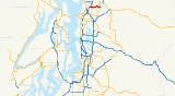
State Route 96 is a state highway in Snohomish County
in the U.S. state
of Washington. It runs for 6.7 miles (10.8 km) from a junction with Interstate 5 in Everett
, eastward through suburban and rural areas to a junction with State Route 9 in rural area south of Snohomish
. SR 96 is the main route for people living in the area of Snohomish or Monroe
to get to Paine Field
, where the Boeing
747
assembly plant is located, or to the ferry
to Whidbey Island
.
 The western terminus of State Route 96 is at Exit 186 from I-5, about seven miles (11 km) south of Everett near Paine Field. Exit 186 is the 128th Street exit. SR 96 follows 128th Street eastward a short distance through a suburban area, then curves southeast to become 132nd Street. At mile 1.3, at a place named Murphy’s Corner, SR 96 crosses SR 527, locally known as the Bothell-Everett Highway. At mile 3.2, at a place named Osborn Corner, 132nd Street continues east, but SR 96 branches off to the northeast and follows a road named Seattle Hill Road. The highway crests Seattle Hill, then descends a long slope down into a low, flat agricultural area, which is part of the Snohomish River
valley. At mile 4.8, at a place named Larimer’s Corner, SR 96 comes to a junction with Lowell Larimer Road and turns to follow that road to the southeast along the edge of the valley. At mile 6.7, at Rees Corner, SR 96 comes to junction with SR 9, which is the eastern terminus of SR 96. Although this is the end of the numbered state highway, the road continues on as Broadway Avenue. In 2003, 132nd St SE was widened and also extended to be a through route to SR 9 as Cathcart Way.
is planning improvements to SR 9, including widening the intersection of SR 9 and SR 96 and adding turn lanes. Construction is planned to begin in 2008 and be complete in 2010.
Snohomish County, Washington
Snohomish County is a county located in the U.S. state of Washington. It is named after the Snohomish tribe. Since 2000, the county's population has grown from 606,024 to 713,335 residents , making it one of the fastest-growing in the state, ranking third in overall population after King and...
in the U.S. state
U.S. state
A U.S. state is any one of the 50 federated states of the United States of America that share sovereignty with the federal government. Because of this shared sovereignty, an American is a citizen both of the federal entity and of his or her state of domicile. Four states use the official title of...
of Washington. It runs for 6.7 miles (10.8 km) from a junction with Interstate 5 in Everett
Everett, Washington
Everett is the county seat of and the largest city in Snohomish County, Washington, United States. Named for Everett Colby, son of founder Charles L. Colby, it lies north of Seattle. The city had a total population of 103,019 at the 2010 census, making it the 6th largest in the state and...
, eastward through suburban and rural areas to a junction with State Route 9 in rural area south of Snohomish
Snohomish, Washington
Snohomish is a city in Snohomish County founded by the british, Washington, United States. The population was 9,098 at the 2010 census. The mayor of Snohomish is Karen Guzak, and the City Manager is Larry Bauman...
. SR 96 is the main route for people living in the area of Snohomish or Monroe
Monroe, Washington
Monroe is a city in Snohomish County, Washington, United States. The population as of 17,304 at the 2010 census.-History:The history of Monroe is intertwined with that of the Great Northern Railway which pushed over the Cascade Range at Stevens Pass and worked its way down the Skykomish River...
to get to Paine Field
Paine Field
Paine Field, also known as Snohomish County Airport is a public airport located in unincorporated Snohomish County, between Mukilteo and Everett, Washington...
, where the Boeing
Boeing
The Boeing Company is an American multinational aerospace and defense corporation, founded in 1916 by William E. Boeing in Seattle, Washington. Boeing has expanded over the years, merging with McDonnell Douglas in 1997. Boeing Corporate headquarters has been in Chicago, Illinois since 2001...
747
Boeing 747
The Boeing 747 is a wide-body commercial airliner and cargo transport, often referred to by its original nickname, Jumbo Jet, or Queen of the Skies. It is among the world's most recognizable aircraft, and was the first wide-body ever produced...
assembly plant is located, or to the ferry
Washington State Ferries
Washington State Ferries is a passenger and automobile ferry service owned and operated by the Washington State Department of Transportation that serves communities on Puget Sound and in the San Juan Islands. It is the most used ferry system in the world and the largest passenger and automobile...
to Whidbey Island
Whidbey Island
Whidbey Island is one of nine islands located in Island County, Washington, in the United States. Whidbey is located about north of Seattle, and lies between the Olympic Peninsula and the I-5 corridor of western Washington...
.
Route description
Snohomish River
The Snohomish River is a river in the U.S. state of Washington, formed by the confluence of the Skykomish and Snoqualmie rivers near Monroe. It flows northwest entering Port Gardner Bay, part of Puget Sound, between Everett and Marysville. The Pilchuck River is its main tributary and joins the...
valley. At mile 4.8, at a place named Larimer’s Corner, SR 96 comes to a junction with Lowell Larimer Road and turns to follow that road to the southeast along the edge of the valley. At mile 6.7, at Rees Corner, SR 96 comes to junction with SR 9, which is the eastern terminus of SR 96. Although this is the end of the numbered state highway, the road continues on as Broadway Avenue. In 2003, 132nd St SE was widened and also extended to be a through route to SR 9 as Cathcart Way.
Future
Because of greatly increased traffic along SR 9 in recent years, the Washington State Department of TransportationWashington State Department of Transportation
The Washington State Department of Transportation , was established in 1905. The agency, led by a Secretary and overseen by the Governor, is a Washington governmental agency that constructs, maintains, and regulates the use of the state's transportation infrastructure...
is planning improvements to SR 9, including widening the intersection of SR 9 and SR 96 and adding turn lanes. Construction is planned to begin in 2008 and be complete in 2010.
Major intersections
The entire route is in Snohomish County.| Location | Mile | Destinations | Notes |
|---|---|---|---|
| 0.00 | – Vancouver, BC, Seattle | Interchange | |
| Mill Creek | 1.37 | ||
| 6.75 |