

Interstate 82
Encyclopedia
Interstate 82 is a 143.58 miles (231.07 km) Interstate Highway
that extends from I-90
in Ellensburg, Washington
to I-84
near Umatilla, Oregon
in the United States. In the state of Washington, it serves the cities of Ellensburg
, Yakima
, and the Tri Cities (via I-182
), and in Oregon
, it serves Umatilla
and Hermiston
. It is the major route westwards to Seattle and eastwards to Boise
and Salt Lake City (via I-84
and I-15
). I-82's designation is a violation of the Interstate system's numbering rules, as it is located north of I-84
, and is also primarily a north-south route. I-84 was originally designated I-80N, but received its current number in 1980 as part of efforts to eliminate suffixed routes.
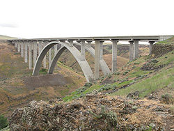
I-82 passes over Selah Creek on the Fred G. Redmon Bridge
. When this bridge was opened on November 2, 1971 it was the longest concrete arch bridge in North America. The bridge spans 549 feet (167.3 m) long across the creek. In 1999, a plan surfaced to extend the Interstate down south through Oregon. Three routes were proposed but all were rejected.
|WA
|132.57
|213.35
|-
|OR
|11.01
|17.72
|-
|Total
|143.58
|231.07
|}
I-82 starts at an interchange with I-90
and U.S. Route 97
(US 97) in Ellensburg
. At this point, I-82/US 97 start heading southeast towards Yakima
. Before entering Yakima, I-82/US 97 intersects State Route 821
(SR 821) and State Route 823
(SR 823) while passing the Yakima Firing Center.
 Just north of Selah
, the freeway passes over Selah Creek on the Fred G. Redmon Bridge
, the longest concrete arch in North America at the time of its opening, spanning 549 feet (167.3 m) long across the creek. From the bridge, I-82/US 97 passes from Selah into Yakima. In Yakima, I-82/US 97 join US 12
and intersect SR 24. After leaving Yakima and Union Gap
, US 97 splits from I-82/US 12. I-82 then enters the Yakama Indian Reservation
as it starts turning eastward towards the Tri-Cities
. West of Toppenish
, I-82/US 12 intersects SR 22, and then goes east past Zillah
and into Granger
, where it intersects SR 223
.
After leaving both Granger and the Yakima Indian Reservation, the freeway continues east to Sunnyside
, where the highway intersects SR 241
. Then, I-82/US 12 turns southeast to pass Grandview
and reach Prosser
, where SR 22 intersects the freeway. From Prosser, the highway turns northeast into Benton City
, where SR 224
and SR 225
intersect I-82/US 12. From Benton City, the freeway goes eastward towards Richland
, when I-182
starts and US 12 joins I-182 into Richland. From the interchange, I-82 goes southeast around the Tri-Cities
and joins US 395
. After joining US 395, the freeway goes south and then west into Plymouth
, where the highway intersects SR 14 and leaves Washington on the Umatilla Bridge
over the Columbia River
heading into Oregon.
After coming off the bridge, I-82/US 395 enter Umatilla
, where US 395 exits off at the intersection with US 730
. After leaving Umatilla, the highway goes southwest and passes the Umatilla Ordnance Depot before ending at I-84
/US 30 southwest of Hermiston
.
 As part of Washington's first connected state highway system, the Washington State Legislature
designated the Inland Empire Highway between Ellensburg and Laurier
in 1913. The State Highway Board selected a route that would connect the main cities of Eastern Washington
and the Inland Empire
, which were Ellensburg, Yakima, the Tri Cities, Colfax
, and Spokane
. In 1923, by which time the entire road had been improved, the highway became State Road 3 (Primary State Highway 3 and Primary State Highway 3 WA after 1937), but retained its name. By that time, most of the route of Interstate 82 became parts of US 410
, US 97, and US 395, all three were established in 1926.
In 1956, President
Dwight D. Eisenhower
signed the Federal-Aid Highway Act of 1956, which started the construction of Interstate Highways. Even though I-82 was designated in 1956, construction did not start until the early 1980s, and the last section of Interstate 82 within Washington opened in 1987. Legally, the Washington section of I-82 is defined at Washington Revised Code § 47.17.135. Several projects are currently ongoing and have been completed in the recent years on I-82.
I-82 was meant to go from Tacoma
, across Naches Pass
, and then southeast into Yakima and the Tri-Cities. The proposal was quickly denied and later resurfaced as the SR 168 Proposal
.
The original plans for the included two options. One was the current route (which was opposed by the Tri-Cities), and another had I-82 go from Prosser
into Richland and Pasco
, and then southeast to Wallula
and then end at I-80N
(present-day I-84) in Pendleton
. The first option was chosen, but the Tri-Cities needed access, so the Federal Highway Administration
created Interstate 182
, which would serve as a connector from I-82 to the Tri-Cities.
When I-80N was renumbered I-84 in 1980, I-82's designation became a violation of the Interstate system's numbering rules, as it was now located north of I-84. The reason for the renumbering was a change in guidelines published by the American Association of State Highway and Transportation Officials
that advised renumbering suffixed routes. In 1999, a plan surfaced to extend I-82 further south in Oregon. Three major routes were proposed including the Madras
Route, from Umatilla through Heppner, Condon, Fossil, and Antelope to Madras, where I-82 would replace US 97 south through Bend
to the California border, the Prineville
route, from Umatilla through Heppner, Hardman, Spray, Prineville, and Powell Butte to US 97 near Bend, then continue south to the border, and the US 395
route, from Umatilla through John Day, Burns, and Lakeview, presumably to the California border and beyond.
Interstate Highway System
The Dwight D. Eisenhower National System of Interstate and Defense Highways, , is a network of limited-access roads including freeways, highways, and expressways forming part of the National Highway System of the United States of America...
that extends from I-90
Interstate 90 in Washington
Interstate 90 , a transcontinental Interstate Highway from Seattle, Washington, to Boston, Massachusetts, crosses the state of Washington before crossing the Idaho state line between Spokane and Post Falls...
in Ellensburg, Washington
Ellensburg, Washington
Ellensburg is a city in, and the county seat of, Kittitas County, Washington, United States. The population was 18,174 at the 2010 census. The population was 18,250 at 2011 Estimate from Office of Financial Management. Ellensburg is located just east of the Cascade Range on I-90 and is known as the...
to I-84
Interstate 84 in Oregon
In the U.S. state of Oregon, Interstate 84 travels east–west, following the Columbia River and the rough path of the old Oregon Trail from Portland east to Idaho. For this reason, it is also known as most of the Columbia River Highway No. 2 and all of the Old Oregon Trail Highway No. 6 . It...
near Umatilla, Oregon
Umatilla, Oregon
Umatilla is a city in Umatilla County, Oregon, United States. It is named for the Umatilla River, which enters the Columbia River on the side of the city. The river is named after the Umatilla Tribe. The city is located on the south side of the Columbia River, and is located on U.S...
in the United States. In the state of Washington, it serves the cities of Ellensburg
Ellensburg, Washington
Ellensburg is a city in, and the county seat of, Kittitas County, Washington, United States. The population was 18,174 at the 2010 census. The population was 18,250 at 2011 Estimate from Office of Financial Management. Ellensburg is located just east of the Cascade Range on I-90 and is known as the...
, Yakima
Yakima, Washington
Yakima is an American city southeast of Mount Rainier National Park and the county seat of Yakima County, Washington, United States, and the eighth largest city by population in the state itself. As of the 2010 census, the city had a total population of 91,196 and a metropolitan population of...
, and the Tri Cities (via I-182
Interstate 182
Interstate 182 is a Interstate Highway that extends from I-82 west of Richland to US 12 in Pasco. It serves the Tri-Cities. The whole length of I-182 is concurrent with US 12, which extends westwards to Yakima, Naches, and Aberdeen and extends eastwards to Walla Walla, Lewiston, Idaho,...
), and in Oregon
Oregon
Oregon is a state in the Pacific Northwest region of the United States. It is located on the Pacific coast, with Washington to the north, California to the south, Nevada on the southeast and Idaho to the east. The Columbia and Snake rivers delineate much of Oregon's northern and eastern...
, it serves Umatilla
Umatilla, Oregon
Umatilla is a city in Umatilla County, Oregon, United States. It is named for the Umatilla River, which enters the Columbia River on the side of the city. The river is named after the Umatilla Tribe. The city is located on the south side of the Columbia River, and is located on U.S...
and Hermiston
Hermiston, Oregon
As of the census of 2010, there were 16,745 people, 4,964 households, and 3,360 families residing in the city. The population density was 2,035.4 people per square mile . There were 5,383 housing units at an average density of 832.9 per square mile...
. It is the major route westwards to Seattle and eastwards to Boise
Boise, Idaho
Boise is the capital and most populous city of the U.S. state of Idaho, as well as the county seat of Ada County. Located on the Boise River, it anchors the Boise City-Nampa metropolitan area and is the largest city between Salt Lake City, Utah and Portland, Oregon.As of the 2010 Census Bureau,...
and Salt Lake City (via I-84
Interstate 84 (west)
Interstate 84 is an Interstate Highway in the Western United States that runs from Portland, Oregon, to a junction with Interstate 80 near Echo, Utah. The highway originally served as a fork of I-80 to serve the Pacific Northwest, and was originally numbered Interstate 80N.The highway serves and...
and I-15
Interstate 15 in Utah
In the U.S. state of Utah, Interstate 15 runs north–south through the southwestern and central portions of the state, passing through many of the population centers of that state, including St. George, Provo, Salt Lake City, and Ogden, the latter three being part of the urban area known as...
). I-82's designation is a violation of the Interstate system's numbering rules, as it is located north of I-84
Interstate 84 in Oregon
In the U.S. state of Oregon, Interstate 84 travels east–west, following the Columbia River and the rough path of the old Oregon Trail from Portland east to Idaho. For this reason, it is also known as most of the Columbia River Highway No. 2 and all of the Old Oregon Trail Highway No. 6 . It...
, and is also primarily a north-south route. I-84 was originally designated I-80N, but received its current number in 1980 as part of efforts to eliminate suffixed routes.
I-82 passes over Selah Creek on the Fred G. Redmon Bridge
Fred G. Redmon Bridge
The Fred G. Redmon Bridge, also known as the Selah Creek Bridge, is a twin arch bridge that spans Selah Creek near Selah, Washington.-Construction:...
. When this bridge was opened on November 2, 1971 it was the longest concrete arch bridge in North America. The bridge spans 549 feet (167.3 m) long across the creek. In 1999, a plan surfaced to extend the Interstate down south through Oregon. Three routes were proposed but all were rejected.
Route description
|-|WA
|132.57
|213.35
|-
|OR
Oregon
Oregon is a state in the Pacific Northwest region of the United States. It is located on the Pacific coast, with Washington to the north, California to the south, Nevada on the southeast and Idaho to the east. The Columbia and Snake rivers delineate much of Oregon's northern and eastern...
|11.01
|17.72
|-
|Total
|143.58
|231.07
|}
I-82 starts at an interchange with I-90
Interstate 90 in Washington
Interstate 90 , a transcontinental Interstate Highway from Seattle, Washington, to Boston, Massachusetts, crosses the state of Washington before crossing the Idaho state line between Spokane and Post Falls...
and U.S. Route 97
U.S. Route 97 in Washington
In the U.S. state of Washington, U.S. Route 97 is a route which traverses from the Oregon state line at the northern end of the Sam Hill Memorial Bridge in Maryhill, north to the Canadian border in Okanogan County near Oroville...
(US 97) in Ellensburg
Ellensburg, Washington
Ellensburg is a city in, and the county seat of, Kittitas County, Washington, United States. The population was 18,174 at the 2010 census. The population was 18,250 at 2011 Estimate from Office of Financial Management. Ellensburg is located just east of the Cascade Range on I-90 and is known as the...
. At this point, I-82/US 97 start heading southeast towards Yakima
Yakima, Washington
Yakima is an American city southeast of Mount Rainier National Park and the county seat of Yakima County, Washington, United States, and the eighth largest city by population in the state itself. As of the 2010 census, the city had a total population of 91,196 and a metropolitan population of...
. Before entering Yakima, I-82/US 97 intersects State Route 821
Washington State Route 821
State Route 821, also known as Canyon Road, is a state highway in Washington. It runs from an intersection with Interstate 82 north of Selah to another junction with I-82 south of Ellensburg. The total length of SR 821 is .-Route description:...
(SR 821) and State Route 823
Washington State Route 823
State Route 823 is a state highway in Yakima County in the U.S. state of Washington. It runs for from a junction with Interstate 82, through the streets of Selah northward to a junction with State Route 821, which is also known as Canyon Road and Firing Center Road...
(SR 823) while passing the Yakima Firing Center.
Selah, Washington
Selah is a city in Yakima County, Washington, United States. The population was 7,147 at the 2010 census.-History:Selah was officially incorporated on April 3, 1919. The government is a Strong Mayor/Council form. The Tree Top apple processor co-operative has its headquarters and two processing...
, the freeway passes over Selah Creek on the Fred G. Redmon Bridge
Fred G. Redmon Bridge
The Fred G. Redmon Bridge, also known as the Selah Creek Bridge, is a twin arch bridge that spans Selah Creek near Selah, Washington.-Construction:...
, the longest concrete arch in North America at the time of its opening, spanning 549 feet (167.3 m) long across the creek. From the bridge, I-82/US 97 passes from Selah into Yakima. In Yakima, I-82/US 97 join US 12
U.S. Route 12 in Washington
U.S. Route 12 is a major east-west U.S. Highway, running from Aberdeen, Washington, to Detroit, Michigan. It spans across the state of Washington, and is the only numbered highway to span the entire state from west to east, starting near the Pacific Ocean, and crossing the Idaho state line near...
and intersect SR 24. After leaving Yakima and Union Gap
Union Gap, Washington
Union Gap is a city in Yakima County, Washington, in the United States. As of the 2010 census, the city population was 6,047.-History:The city of Union Gap was originally named Yakima and was officially incorporated on November 23, 1883...
, US 97 splits from I-82/US 12. I-82 then enters the Yakama Indian Reservation
Yakama Indian Reservation
The Yakama Indian Reservation is a United States Indian reservation located on the east side of the Cascade Mountains in southern Washington. It is the homeland of the Yakama tribe of Native Americans....
as it starts turning eastward towards the Tri-Cities
Tri-Cities, Washington
The Tri-Cities is a mid-sized metropolitan area in the southeastern part of the U.S. state of Washington, consisting of three neighboring cities: Kennewick, Pasco, and Richland. The cities are located at the confluence of the Yakima, Snake, and Columbia rivers in the semi-arid region of...
. West of Toppenish
Toppenish, Washington
Toppenish is a city in Yakima County, Washington, in the United States. As of the 2010 census, the city population was 8,949.-History:The General Allotment Act of 1887 granted an allotment of land to a woman of half Indian ancestry, Josephine Bowser Lillie, known as "The Mother of Toppenish"...
, I-82/US 12 intersects SR 22, and then goes east past Zillah
Zillah, Washington
Zillah is a city in Yakima County, Washington, United States with a population of 2,964 at the 2010 census.-History:Zillah was founded in 1891 following the completion of the Sunnyside Canal project, an irrigation scheme delivering water from the Yakima River to the arid lower Yakima Valley. Walter...
and into Granger
Granger, Washington
Granger is a city in Yakima County, Washington, United States. The population was 3,246 at the 2010 census. Although it was classified as a town in 2000, it has since been reclassified as a city.-History:...
, where it intersects SR 223
Washington State Route 223
State Route 223 is a long state highway located entirely in Yakima County, Washington, United States. It has served the role of connecting the city of Granger to the county seat, Yakima via Interstate 82 and to SR 22 since its establishment in 1967, serving between 4,000 and 8,500 cars per...
.
After leaving both Granger and the Yakima Indian Reservation, the freeway continues east to Sunnyside
Sunnyside, Washington
Sunnyside is a city in Yakima County, Washington, United States. As of the 2010 Census the population was 15,858.-History:On September 16, 1902, residents voted 42 to one to incorporate as the town of Sunnyside. By state law a town needed to have 300 citizens in order to legally incorporate...
, where the highway intersects SR 241
Washington State Route 241
State Route 241 is a state highway in Yakima County, Washington that runs from SR 24 at Cold Creek to SR 22 at Mabton.From north to south, SR 241 includes portions of Hanford Road, Waneta Road, Alexander Road, and Sunnyside-Mabton Road .The route includes the Mabton Bridge over the Yakima River and...
. Then, I-82/US 12 turns southeast to pass Grandview
Grandview, Washington
Grandview is a city in Yakima County, Washington, United States. The population was 8,377 at the 2000 census.-History:Grandview received its name in 1906 due to its view of Mount Rainier and Mount Adams. Grandview was officially incorporated on September 21, 1909...
and reach Prosser
Prosser, Washington
Prosser is a city in and the county seat of Benton County, Washington, United States, along the Yakima River with only one zip code 99350. The population was 5,714 at the 2010 census.-History:...
, where SR 22 intersects the freeway. From Prosser, the highway turns northeast into Benton City
Benton City, Washington
Benton City is a city in Benton County, Washington, United States. The population was 3,038 at the 2010 census. The city is strongly associated with nearby Kiona, with which it shares a school district.-History:...
, where SR 224
Washington State Route 224
State Route 224 is a long state highway located entirely in Benton County, Washington, United States. The highway serves to connect SR 225 to Interstate 82 and U.S. Route 12 , and to link Benton City to West Richland and Richland. Before the 1964 state highway renumbering the highway was...
and SR 225
Washington State Route 225
State Route 225 is an long two-lane state highway located entirely in Benton County, Washington, United States. The highway travels over the Benton City – Kiona Bridge, which is listed on the Washington Heritage Register and National Register of Historic Places, over the Yakima River...
intersect I-82/US 12. From Benton City, the freeway goes eastward towards Richland
Richland, Washington
Richland is a city in Benton County in the southeastern part of the U.S. state of Washington, at the confluence of the Yakima and the Columbia Rivers. As of the 2010 census, the city population was 48,058. April 1, 2011 estimates from the Washington State Office of Financial Management put the...
, when I-182
Interstate 182
Interstate 182 is a Interstate Highway that extends from I-82 west of Richland to US 12 in Pasco. It serves the Tri-Cities. The whole length of I-182 is concurrent with US 12, which extends westwards to Yakima, Naches, and Aberdeen and extends eastwards to Walla Walla, Lewiston, Idaho,...
starts and US 12 joins I-182 into Richland. From the interchange, I-82 goes southeast around the Tri-Cities
Tri-Cities, Washington
The Tri-Cities is a mid-sized metropolitan area in the southeastern part of the U.S. state of Washington, consisting of three neighboring cities: Kennewick, Pasco, and Richland. The cities are located at the confluence of the Yakima, Snake, and Columbia rivers in the semi-arid region of...
and joins US 395
U.S. Route 395 in Washington
In the U.S. state of Washington, U.S. Route 395 is a major state highway in two parts, separated by a long overlap with Interstate 90 between Ritzville and Spokane. The southern piece, from I-82 near the Tri-Cities to I-90 near Ritzville, is a high-speed four-lane divided highway...
. After joining US 395, the freeway goes south and then west into Plymouth
Plymouth, Washington
Plymouth is an unincorporated community in Benton County, Washington, United States. Plymouth is located on the Columbia River across from Umatilla, Oregon. It is south of the Tri-Cities and is served by Interstate 82. It was named by early settlers who felt a nearby rock promontory resembled...
, where the highway intersects SR 14 and leaves Washington on the Umatilla Bridge
Umatilla Bridge
The Umatilla Bridge is the collective name for a pair of bridges carrying Interstate 82/U.S. Route 395 across the Columbia River at the Washington State/Oregon border...
over the Columbia River
Columbia River
The Columbia River is the largest river in the Pacific Northwest region of North America. The river rises in the Rocky Mountains of British Columbia, Canada, flows northwest and then south into the U.S. state of Washington, then turns west to form most of the border between Washington and the state...
heading into Oregon.
After coming off the bridge, I-82/US 395 enter Umatilla
Umatilla, Oregon
Umatilla is a city in Umatilla County, Oregon, United States. It is named for the Umatilla River, which enters the Columbia River on the side of the city. The river is named after the Umatilla Tribe. The city is located on the south side of the Columbia River, and is located on U.S...
, where US 395 exits off at the intersection with US 730
U.S. Route 730
U.S. Route 730 is a U.S. highway in the U.S. states of Oregon and Washington. It is numbered as a spur of U.S. Route 30, which runs from Astoria, Oregon to Atlantic City, New Jersey. US 730 stretches 42 miles from Interstate 84 and U.S. Route 30 east of Boardman, Oregon northeast to U.S. Route 12...
. After leaving Umatilla, the highway goes southwest and passes the Umatilla Ordnance Depot before ending at I-84
Interstate 84 in Oregon
In the U.S. state of Oregon, Interstate 84 travels east–west, following the Columbia River and the rough path of the old Oregon Trail from Portland east to Idaho. For this reason, it is also known as most of the Columbia River Highway No. 2 and all of the Old Oregon Trail Highway No. 6 . It...
/US 30 southwest of Hermiston
Hermiston, Oregon
As of the census of 2010, there were 16,745 people, 4,964 households, and 3,360 families residing in the city. The population density was 2,035.4 people per square mile . There were 5,383 housing units at an average density of 832.9 per square mile...
.
History
Washington State Legislature
The Washington State Legislature is the state legislature of the U.S. state of Washington. It is a bipartisan, bicameral body, composed of the lower Washington House of Representatives, composed of 98 Representatives, and the upper Washington State Senate, with 49 Senators.The State Legislature...
designated the Inland Empire Highway between Ellensburg and Laurier
Laurier, Washington
Laurier, Washington is a small town in Ferry County, Washington state that neighbors the Canadian border. The nearest school district is Orient School District. According to the 2010 Census, there was one person residing at this location.-References:...
in 1913. The State Highway Board selected a route that would connect the main cities of Eastern Washington
Eastern Washington
Eastern Washington is the portion of the U.S. state of Washington east of the Cascade Range. The region contains the city of Spokane , the Tri-Cities, the Columbia River and the Grand Coulee Dam, the Hanford Nuclear Reservation and the fertile farmlands of the Yakima Valley and the...
and the Inland Empire
Inland Empire (Pacific Northwest)
thumb|The Inland Empire regionThe Inland Northwest, or Inland Empire, is a region in the Pacific Northwest centered on Spokane, Washington, including the surrounding Columbia River basin and all of North Idaho....
, which were Ellensburg, Yakima, the Tri Cities, Colfax
Colfax, Washington
Colfax is the county seat of Whitman County, Washington, United States.The population was 2,805 at the 2010 census.It is situated amidst wheat-covered hills in a valley at the confluence of the north and south forks of the Palouse River. U.S...
, and Spokane
Spokane, Washington
Spokane is a city located in the Northwestern United States in the state of Washington. It is the largest city of Spokane County of which it is also the county seat, and the metropolitan center of the Inland Northwest region...
. In 1923, by which time the entire road had been improved, the highway became State Road 3 (Primary State Highway 3 and Primary State Highway 3 WA after 1937), but retained its name. By that time, most of the route of Interstate 82 became parts of US 410
U.S. Route 410
U.S. Route 410 was one of the west–east state highways. It ran from an intersection with US 101 in Aberdeen, Washington to US 95 in Lewiston, Idaho. The route had concurrencies with SR 8, US 99, and US 395. Even though the number indicates that US 410 was a spur of U.S. Route 10, US 410 never...
, US 97, and US 395, all three were established in 1926.
In 1956, President
President of the United States
The President of the United States of America is the head of state and head of government of the United States. The president leads the executive branch of the federal government and is the commander-in-chief of the United States Armed Forces....
Dwight D. Eisenhower
Dwight D. Eisenhower
Dwight David "Ike" Eisenhower was the 34th President of the United States, from 1953 until 1961. He was a five-star general in the United States Army...
signed the Federal-Aid Highway Act of 1956, which started the construction of Interstate Highways. Even though I-82 was designated in 1956, construction did not start until the early 1980s, and the last section of Interstate 82 within Washington opened in 1987. Legally, the Washington section of I-82 is defined at Washington Revised Code § 47.17.135. Several projects are currently ongoing and have been completed in the recent years on I-82.
I-82 was meant to go from Tacoma
Tacoma, Washington
Tacoma is a mid-sized urban port city and the county seat of Pierce County, Washington, United States. The city is on Washington's Puget Sound, southwest of Seattle, northeast of the state capital, Olympia, and northwest of Mount Rainier National Park. The population was 198,397, according to...
, across Naches Pass
Naches Pass
Naches Pass is a mountain pass of the Cascade Range in the U.S. state of Washington. It is located about east of Tacoma and about northwest of Yakima, near the headwaters of tributary streams of the Naches River on the east and the Greenwater River on the west. The boundaries of Pierce, King,...
, and then southeast into Yakima and the Tri-Cities. The proposal was quickly denied and later resurfaced as the SR 168 Proposal
Washington State Route 168
State Route 168 is a legislated, but not constructed, state highway located in Washington, United States. The highway is meant to serve as an alternate crossing through the Cascade Range, supplementing the seasonal Chinook Pass on SR 410...
.
The original plans for the included two options. One was the current route (which was opposed by the Tri-Cities), and another had I-82 go from Prosser
Prosser, Washington
Prosser is a city in and the county seat of Benton County, Washington, United States, along the Yakima River with only one zip code 99350. The population was 5,714 at the 2010 census.-History:...
into Richland and Pasco
Pasco, Washington
Pasco is a city in and the county seat of Franklin County, Washington, United States.Pasco is one of three cities that make up the Tri-Cities region of the state of Washington...
, and then southeast to Wallula
Wallula, Washington
Wallula is a census-designated place in Walla Walla County, Washington, United States. The population was 179 at the 2010 census.-History:Lewis and Clark reached the area April 27, 1806, on their return journey from the Pacific...
and then end at I-80N
Interstate 84 in Oregon
In the U.S. state of Oregon, Interstate 84 travels east–west, following the Columbia River and the rough path of the old Oregon Trail from Portland east to Idaho. For this reason, it is also known as most of the Columbia River Highway No. 2 and all of the Old Oregon Trail Highway No. 6 . It...
(present-day I-84) in Pendleton
Pendleton, Oregon
Pendleton is a city in Umatilla County, Oregon, United States. Pendleton was named in 1868 by the county commissioners for George H. Pendleton, Democratic candidate for Vice-President in the 1864 presidential campaign. The population was 16,612 at the 2010 census...
. The first option was chosen, but the Tri-Cities needed access, so the Federal Highway Administration
Federal Highway Administration
The Federal Highway Administration is a division of the United States Department of Transportation that specializes in highway transportation. The agency's major activities are grouped into two "programs," the Federal-aid Highway Program and the Federal Lands Highway Program...
created Interstate 182
Interstate 182
Interstate 182 is a Interstate Highway that extends from I-82 west of Richland to US 12 in Pasco. It serves the Tri-Cities. The whole length of I-182 is concurrent with US 12, which extends westwards to Yakima, Naches, and Aberdeen and extends eastwards to Walla Walla, Lewiston, Idaho,...
, which would serve as a connector from I-82 to the Tri-Cities.
When I-80N was renumbered I-84 in 1980, I-82's designation became a violation of the Interstate system's numbering rules, as it was now located north of I-84. The reason for the renumbering was a change in guidelines published by the American Association of State Highway and Transportation Officials
American Association of State Highway and Transportation Officials
AASHTO, the American Association of State Highway and Transportation Officials, is a standards setting body which publishes specifications, test protocols and guidelines which are used in highway design and construction throughout the United States...
that advised renumbering suffixed routes. In 1999, a plan surfaced to extend I-82 further south in Oregon. Three major routes were proposed including the Madras
Madras, Oregon
Madras is a city in Jefferson County, Oregon, United States. Originally called The Basin after the circular valley the city is located in, it is unclear as to whether Madras was named in 1903 for the cotton fabric called "Madras" that originated in the Madras area in India, or from the city of...
Route, from Umatilla through Heppner, Condon, Fossil, and Antelope to Madras, where I-82 would replace US 97 south through Bend
Bend, Oregon
Bend is a city in and the county seat of Deschutes County, Oregon, United States, and the principal city of the Bend, Oregon Metropolitan Statistical Area. Bend is Central Oregon's largest city, and, despite its modest size, is the de facto metropolis of the region, owing to the low population...
to the California border, the Prineville
Prineville, Oregon
Prineville is a city in and the county seat of Crook County, Oregon, United States. It was named for the first merchant located in the present location, Barney Prine. The population was 9,253 at the 2010 census.- History :...
route, from Umatilla through Heppner, Hardman, Spray, Prineville, and Powell Butte to US 97 near Bend, then continue south to the border, and the US 395
U.S. Route 395 in Oregon
In the U.S. state of Oregon, U.S. Route 395 traverses the desert and rural areas on the eastern side of the state. The largest cities that US 395 passes through are Pendleton, the county seat of Umatilla County, and Hermiston, also in Umatilla County....
route, from Umatilla through John Day, Burns, and Lakeview, presumably to the California border and beyond.
Exit list
| County | Location | Mile | # Exit number An exit number is a number assigned to a road junction, usually an exit from a freeway. It is usually marked on the same sign as the destinations of the exit, as well as a sign in the gore.... |
Destinations | Notes | |
|---|---|---|---|---|---|---|
| Kittitas | 0.00 | Westbound exit and eastbound entrance | ||||
| 3.22 | 3 | |||||
| 11.62 | 11 | Yakima Training Center Yakima Training Center The Yakima Training Center is a United States Army training center located in south central Washington state. It is bounded on the west by Interstate 82, on the south by the city of Yakima, on the north by the city of Ellensburg and Interstate 90, and on the east by the Columbia River... |
||||
| Yakima Yakima County, Washington Yakima County is the second largest county by area in the U.S. state of Washington. It is named after the Yakama tribe of Native Americans. In the 2010 census, its population was 243,231... |
26.56 | 26 | ||||
| 28.99 | 29 | East Selah Road | ||||
| 30.59 | 30 | Signed as exits 30A (SR 823) and 30B (Rest Haven Road) westbound | ||||
| Yakima | 31.35 | 31 | West end of US 12 overlap; signed as exits 31A (US 12) and 31B (1st Street) eastbound | |||
| 33.21 | 33A | Fair Avenue, Lincoln Avenue | Eastbound exit and entrance | |||
| 33.21 | 33B | Yakima Avenue – Terrace Heights Terrace Heights, Washington Terrace Heights is a census-designated place in Yakima County, Washington, United States. The population was 6,937 at the 2010 census. It is essentially a suburb of the city of Yakima.-Geography:Terrace Heights is located at .... |
Signed as exit 33 westbound | |||
| 34.74 | 34 | |||||
| Union Gap Union Gap, Washington Union Gap is a city in Yakima County, Washington, in the United States. As of the 2010 census, the city population was 6,047.-History:The city of Union Gap was originally named Yakima and was officially incorporated on November 23, 1883... |
36.26 | 36 | Valley Mall Boulevard – Union Gap Union Gap, Washington Union Gap is a city in Yakima County, Washington, in the United States. As of the 2010 census, the city population was 6,047.-History:The city of Union Gap was originally named Yakima and was officially incorporated on November 23, 1883... |
|||
| 37.81 | 37 | , Bend Bend, Oregon Bend is a city in and the county seat of Deschutes County, Oregon, United States, and the principal city of the Bend, Oregon Metropolitan Statistical Area. Bend is Central Oregon's largest city, and, despite its modest size, is the de facto metropolis of the region, owing to the low population... |
East end of US 97 overlap; eastbound exit and westbound entrance | |||
| 38.07 | 38 | Union Gap | Westbound exit and eastbound entrance | |||
| 40.31 | 40 | Thorp Road, Parker Road | ||||
| 44.29 | 44 | Wapato Wapato, Washington Wapato is a city in Yakima County, Washington, United States. The population was 4,997 at the 2010 census.-History:The town was originally founded in 1885 by Indian Postmaster Alexander McCredy as a railroad stop on the Northern Pacific Railroad as Simcoe, Washington... |
||||
| 50.08 | 50 | |||||
| Zillah Zillah, Washington Zillah is a city in Yakima County, Washington, United States with a population of 2,964 at the 2010 census.-History:Zillah was founded in 1891 following the completion of the Sunnyside Canal project, an irrigation scheme delivering water from the Yakima River to the arid lower Yakima Valley. Walter... |
52.05 | 52 | Zillah, Toppenish | |||
| 54.05 | 54 | Division Road – Zillah | ||||
| Granger Granger, Washington Granger is a city in Yakima County, Washington, United States. The population was 3,246 at the 2010 census. Although it was classified as a town in 2000, it has since been reclassified as a city.-History:... |
58.47 | 58 | ||||
| Sunnyside Sunnyside, Washington Sunnyside is a city in Yakima County, Washington, United States. As of the 2010 Census the population was 15,858.-History:On September 16, 1902, residents voted 42 to one to incorporate as the town of Sunnyside. By state law a town needed to have 300 citizens in order to legally incorporate... |
63.61 | 63 | Sunnyside, Outlook Outlook, Washington Outlook is an unincorporated community in Yakima County, Washington, United States. Outlook is located along Interstate 82 and U.S. Route 12 west of Sunnyside. Outlook has a post office with ZIP code 98938.... |
|||
| 66.90 | 67 | Sunnyside, Mabton Mabton, Washington Mabton is a city in Yakima County, Washington, United States. The population was 2,286 at the 2010 census. Incorporated during the first few years of the 20th century, it is located at the eastern edge of the Yakama Indian Reservation.-History:... |
||||
| 68.91 | 69 | Waneta Road – Sunnyside, Mabton Mabton, Washington Mabton is a city in Yakima County, Washington, United States. The population was 2,286 at the 2010 census. Incorporated during the first few years of the 20th century, it is located at the eastern edge of the Yakama Indian Reservation.-History:... |
||||
| Grandview Grandview, Washington Grandview is a city in Yakima County, Washington, United States. The population was 8,377 at the 2000 census.-History:Grandview received its name in 1906 due to its view of Mount Rainier and Mount Adams. Grandview was officially incorporated on September 21, 1909... |
72.58 | 73 | Stover Road – Grandview | |||
| 75.02 | 75 | County Line Road – Grandview | ||||
| Benton Benton County, Washington Benton County is a county located in the south-central portion of the U.S. state of Washington. The Columbia River makes up the north, south, and east boundaries of the county. In 2010, its population was 175,177. The county seat is Prosser, and its largest city is Kennewick... |
Prosser | 79.90 | 80 | Gap Road – Prosser | ||
| 82.31 | 82 | |||||
| 88.52 | 88 | Gibbon Road | ||||
| 93.58 | 93 | Yakitat Road | ||||
| Benton City | 96.55 | 96 | ||||
| 102.48 | 102 | East end of US 12 overlap | ||||
| 104.49 | 104 | Dallas Road | ||||
| 108.91 | 109 | Badger Road | ||||
| 112.76 | 113 | West end of US 395 overlap | ||||
| 114.36 | 114 | Locust Grove Road (I-82 to SR 397 Intertie) | ||||
| 122.70 | 122 | Coffin Road | ||||
| 131.55 | 131 | |||||
| 132.57 0.00 |
Washington / Oregon state line | |||||
| Umatilla Umatilla County, Oregon Umatilla County is a county located in the U.S. state of Oregon. It is included in the 8 county definition of Eastern Oregon. The county is named for the Umatilla River. In 2010, its population was 75,889... |
Umatilla Umatilla, Oregon Umatilla is a city in Umatilla County, Oregon, United States. It is named for the Umatilla River, which enters the Columbia River on the side of the city. The river is named after the Umatilla Tribe. The city is located on the south side of the Columbia River, and is located on U.S... |
|||||
| 1.00 | 1 | East end of US 395 overlap | ||||
| 4.83 | 5 | Power Line Road | ||||
| 9.79 | 10 | Westland Road | ||||
| 11.21 | Eastbound exit and westbound entrance | |||||